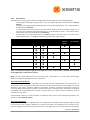
1
MTi-G User Manual and Technical Documentation Document MT0137P, Revision G, 27 May 2009 Xsens Technologies B.V. phone +31 88 97367 00 fax +31 88 97367 01 email [email protected] internet www.xsens.com Revisions Revision Date By Changes A October 20 2007 PSL First version. B April 1 2008 PSL C July 1 2008 PSL D August 8 2008 MMI Various editorial updates. Removed section on using MT Manager, please refer to MT Manager User Manual Added Origin of MTi‐G, section 6.6 Updated performance specification for new generation devices Updated to include new device type with 18g acc range Various editorial changes and additions Added and updated DoC Various editorial changes and additions E October 31 2008 RGI F February 2, 2009 PSL G May 27, 2009 MHA Operating temperature range modified Added FCC DoC and CE DoC for the USB converters Updated product specification for MTi‐G’s with Device ID higher than 00501000. Added marine scenario specification Added Test & Calibration certificate explanation Added timing specification Added considerations for placement and laptop use Changed Raw GPS to GPS PVT Reworked section on co‐ordinate systems definitions Minor updates New corporate design © 2007‐2009, Xsens Technologies B.V. All rights reserved. Information in this document is subject to change without notice. Xsens is a registered trademark of Xsens Technologies B.V. MTi and MTx are trademarks of Xsens Technologies B.V. © Xsens Technologies B.V. ii Document MT0137P.G MTi‐G User Manual and Technical Documentation Table of Contents 1 INTRODUCTION .................................................................................................................................... 1 1.1 PRODUCT DESCRIPTION .................................................................................................................................. 1 1.1.1 MTi‐G – miniature GPS/INS ............................................................................................................. 1 1.2 OVERVIEW MTI‐G DEVELOPMENT KIT ............................................................................................................... 3 1.3 QUICK START ‐ DIFFERENT WAYS OF INTERFACING TO THE MTI‐G ............................................................................ 4 1.3.1 Getting Started with the MT Manager ............................................................................................ 4 1.3.2 Interface through COM‐object API .................................................................................................. 4 1.3.3 Interface through DLL API ............................................................................................................... 4 1.3.4 Direct low‐level communication with MTi‐G ................................................................................... 5 2 MTI‐G SYSTEM OVERVIEW .................................................................................................................... 5 2.1 ARCHITECTURE OVERVIEW ............................................................................................................................... 5 2.2 XSENS KALMAN FILTER FOR MTI‐G ................................................................................................................... 6 2.2.1 Dead reckoning using inertial sensors ............................................................................................. 6 2.2.2 Position and orientation correction using GPS ................................................................................ 6 2.2.3 Altitude correction using a static pressure sensor ........................................................................... 8 2.2.4 Heading observability ...................................................................................................................... 8 2.2.5 Handling of GPS Outages ................................................................................................................ 9 2.2.6 XKF Scenarios ................................................................................................................................ 10 2.3 LIMITATIONS ............................................................................................................................................... 12 3 INSTALLATION AND OPERATION ......................................................................................................... 13 3.1 INSTALLATION ............................................................................................................................................. 13 3.1.1 Hardware Setup............................................................................................................................. 13 3.1.2 First use ......................................................................................................................................... 14 3.2 NORMAL OPERATING PROCEDURE ................................................................................................................... 15 3.3 GPS ANTENNA POSITIONING WITH RESPECT TO MTI‐G ....................................................................................... 16 3.4 PLACEMENT CONSIDERATIONS ........................................................................................................................ 17 3.4.1 Transient accelerations during GPS outages ................................................................................. 17 3.4.2 Vibrations ...................................................................................................................................... 17 3.4.3 Magnetic materials and magnets ................................................................................................. 17 3.4.4 Atmospheric pressure .................................................................................................................... 18 3.5 RF INTERFERENCE AND REFLECTIONS AND GPS ANTENNA PLACEMENT .................................................................... 18 3.5.1 RF interference .............................................................................................................................. 18 3.5.2 Reflections ..................................................................................................................................... 19 4 OUTPUT SPECIFICATION ..................................................................................................................... 20 4.1 CO‐ORDINATE SYSTEM DEFINITIONS ................................................................................................................. 20 4.1.1 Default MTi‐G co‐ordinate system definitions............................................................................... 20 4.1.2 Default MTi‐G body fixed co‐ordinate system ............................................................................... 21 4.1.3 Locally tangent plane Euclidian linearized coordinate system ‐ LTP ............................................. 22 4.1.4 Default definition of G and S ......................................................................................................... 22 4.1.5 True North vs. Magnetic North ..................................................................................................... 23 4.1.6 North East Down optional MTi‐G co‐ordinate system definitions ................................................. 23 4.1.7 Linearization errors and relation WGS84 and LTP ......................................................................... 24 4.2 PERFORMANCE SPECIFICATION ....................................................................................................................... 27 4.3 ORIENTATION OUTPUT MODES ....................................................................................................................... 28 4.3.1 Quaternion orientation output mode ............................................................................................ 29 4.3.2 Euler angles orientation output mode .......................................................................................... 30 4.3.3 Rotation Matrix orientation Output Mode .................................................................................... 31 Document MT0137P.G © Xsens Technologies B.V. MTi‐G User Manual and Technical Documentation iii 4.4 POSITION AND VELOCITY OUTPUT MODE ......................................................................................................... 32 4.5 STATUS BYTE (BIT) ...................................................................................................................................... 33 4.6 CALIBRATED DATA PERFORMANCE SPECIFICATION ............................................................................................... 33 4.7 CALIBRATED DATA OUTPUT MODE ................................................................................................................... 34 4.7.1 Physical sensor model ................................................................................................................... 34 4.7.2 Calibrated inertial and magnetic data output mode ..................................................................... 35 4.8 RAW DATA OUTPUT MODES ........................................................................................................................ 36 4.8.1 RAW inertial sensor data Output Mode ........................................................................................ 36 4.8.2 GPS PVT data Output Mode .......................................................................................................... 37 4.9 RESET OF OUTPUT OR REFERENCE CO‐ORDINATE SYSTEMS .................................................................................... 38 4.9.1 Output with respect to non‐default coordinate frames ................................................................ 38 4.9.2 Arbitrary Object alignment ........................................................................................................... 38 4.9.3 Object reset ................................................................................................................................... 39 4.10 TIMESTAMP OUTPUT ............................................................................................................................... 40 4.11 MTI‐G CLOCK BIAS ESTIMATION TO UTC ..................................................................................................... 40 4.12 TEST AND CALIBRATION CERTIFICATE .......................................................................................................... 41 5 MT COMMUNICATION PROTOCOL ...................................................................................................... 42 5.1 INTRODUCTION ........................................................................................................................................... 42 5.2 MT DEVICE STATES ...................................................................................................................................... 42 5.3 MT MESSAGES ........................................................................................................................................... 44 5.3.1 Message structure ......................................................................................................................... 44 5.3.2 Message usage .............................................................................................................................. 44 5.3.3 Common messages ........................................................................................................................ 46 5.4 COMMUNICATION TIMING............................................................................................................................. 50 5.5 TRIGGERING & SYNCHRONIZATION .................................................................................................................. 52 5.5.1 MTi‐G triggers external devices ..................................................................................................... 52 5.6 INTERNAL CLOCK ACCURACY ........................................................................................................................... 53 5.7 DEFAULT SERIAL CONNECTION SETTINGS .......................................................................................................... 54 5.7.1 General definitions for binary data ............................................................................................... 54 6 PHYSICAL SPECIFICATIONS .................................................................................................................. 55 6.1 PHYSICAL SENSOR OVERVIEW ......................................................................................................................... 55 6.2 PHYSICAL PROPERTIES OVERVIEW .................................................................................................................... 55 6.2.1 MTi‐G physical specifications overview ......................................................................................... 55 6.3 POWER SUPPLY ........................................................................................................................................... 56 6.4 PHYSICAL INTERFACE SPECIFICATIONS ............................................................................................................... 56 6.4.1 USB‐serial data and power cables overview ................................................................................. 56 6.4.2 Pin and wire color definitions MTi‐G‐28A##G## (MTi‐G RS‐232, standard version) ..................... 57 6.4.3 Additional interface specifications ................................................................................................ 58 6.5 HOUSING MECHANICAL SPECIFICATIONS ........................................................................................................... 59 6.5.1 Dimensions MTi‐G ......................................................................................................................... 60 6.6 PHYSICAL LOCATION OF ORIGIN OF THE MTI‐G .................................................................................................. 61 6.7 GPS ANTENNA ELECTRICAL AND MECHANICAL SPECIFICATIONS .............................................................................. 62 6.7.1 Not using the default Wi‐sys WS3910 antenna ............................................................................. 63 7 IMPORTANT NOTICES ......................................................................................................................... 64 7.1 7.2 7.3 7.4 7.5 ENVIRONMENTAL OPERATING CONDITIONS ...................................................................................................... 64 FCC SPECIFIC OPERATING INSTRUCTIONS .......................................................................................................... 64 SAFETY INSTRUCTIONS .................................................................................................................................. 65 ABSOLUTE MAXIMUM RATINGS ....................................................................................................................... 65 MAINTENANCE ............................................................................................................................................ 65 © Xsens Technologies B.V. iv Document MT0137P.G MTi‐G User Manual and Technical Documentation 7.5.1 Cleaning ......................................................................................................................................... 65 7.6 WARRANTY AND LIABILITY ............................................................................................................................. 66 7.7 CE DECLARATION OF CONFORMITY FOR THE MT DEVICES .................................................................................... 67 7.8 FCC DECLARATION OF CONFORMITY FOR THE MT DEVICES .................................................................................. 68 7.9 CE DECLARATION OF CONFORMITY FOR THE USB CONVERTERS ............................................................................ 69 7.10 FCC DECLARATION OF CONFORMITY FOR THE USB CONVERTERS...................................................................... 70 7.11 POWER SUPPLY CONSIDERATIONS FOR CONDUCTIVE HF EMISSION .................................................................... 71 7.12 CUSTOMER SUPPORT ............................................................................................................................... 72 © Xsens Technologies B.V. v Document MT0137P.G MTi‐G User Manual and Technical Documentation 1 Introduction The MTi‐G is an integrated GPS and Inertial Measurement Unit (IMU) with a Navigation and Attitude and Heading Reference System (AHRS) processor. The MTi‐G is based on MEMS inertial sensors and a miniature GPS receiver and also includes additional aiding sensors; a 3D magnetometer and a static pressure sensor. The MTi‐G delivers unprecedented performance for its size, weight, cost and low complexity in use. The MTi‐G is designed to be relatively robust and is very flexible, providing a wide range of interface options, as well as advanced settings for specific usage scenarios. This documentation describes the use, basic communication interfaces, performance specifications, physical specifications and usage guidelines of the MTi‐G. The MTi‐G is part of a family of inertial Motion Trackers from Xsens Technologies B.V. The product line also features the MTi and MTx, both miniature MEMS based inertial measurement units with integrated 3D magnetometers, embedded signal processing and digital output. 1.1 1.1.1 Product Description MTi‐G – miniature GPS/INS The MTi‐G is an integrated GPS and MEMS Inertial Measurement Unit with a Navigation and Attitude and Heading Reference System processor. The internal low‐power signal processor runs a real‐time Xsens Kalman Filter (XKF) providing inertial enhanced 3D position and velocity estimates. The MTi‐G also provides drift‐free, GPS enhanced, 3D orientation estimates, as well as calibrated 3D acceleration, 3D rate of turn, 3D earth‐ magnetic field data and static pressure (barometer). The MTi‐G is an excellent measurement unit for navigation and control of vehicles and other objects. Fields of use • robotics • aerospace • autonomous vehicles • marine industry • automotive applications Features • real‐time computation of inertial enhanced position/velocity and GPS enhanced attitude/heading on embedded DSP 1 • built‐in 50 channel Global Position System (GPS) receiver • ‐160 dBm tracking sensitivity • high immunity to GPS interference (jamming) • Time to first GPS fix < 1s (hot start) • GALILEO‐L1 compatible when signals become available (firmware update required) • accurate full 360 degrees 3D orientation output (Attitude and Heading) • 3D acceleration, 3D rate of turn and 3D earth‐magnetic field data • static pressure sensor (barometer) MTi‐G’s with Device ID’s (DID) higher than 00501000 have a 50 channel GPS L1 receiver prepared for GALILEO compatibility. Please refer to revision E or earlier for documentation and specification of devices with lower DID’s. Document MT0137P.G © Xsens Technologies B.V. MTi‐G User Manual and Technical Documentation 1 1 • • • • • • • • • • • high update rate (120 Hz on embedded DSP, 512 Hz inertial data only) UTC referenced output compact design low weight ultra‐low power consumption various digital output modes all solid state miniature MEMS inertial sensors inside individually calibrated for temperature, 3D misalignment and sensor cross‐sensitivity built‐in test (BIT) feature antenna fault detection external active antenna status detection circuit © Xsens Technologies B.V. 2 Document MT0137P.G MTi‐G User Manual and Technical Documentation 1.2 Overview MTi‐G Development Kit Contents MTi‐G Development Kit • MTi‐G miniature GPS/INS (MTi‐G‐28A##G##) • GPS antenna (ANT) • Device individual Calibration Certificate • A letter with your individual software license code. • USB‐serial data and power cable, 3 meters • MTi‐G Quick Setup Sheet • MTi‐G User Manual and Technical Documentation [MT0137P] • MT Software Development Kit CD‐ROM o MT Low level communication Documentation PDF [MT0101P] o MTi‐G Quick Setup PDF o MT SDK setup Xsens WHQL USB driver MT Manager XsensCMT.DLL • COM‐object Level 4 • DLL C‐interface XsensCMTstatic.LIB CMT Source files (C++) Example source code (MATLAB) Documentation • MTi‐G User Manual and Technical Documentation [MT0137P] • MT Low level communication Documentation [MT0101P] • MT Magnetic Field Mapper Documentation [MT0202P] • CMT doxygen HTML documentation NOTE: the most recent version of the software, source code and documentation can always be downloaded on the support section of www.xsens.com. When updating the firmware in your MTi‐G, please make sure to use the latest Firmware Updater (as part of the MT SDK) and the latest firmware, which are all available at our website www.xsens.com. Not using the up‐to‐date Firmware and/or Firmware Updater can render your sensor inoperable in which case the sensor may need to be returned to Xsens for recovery. © Xsens Technologies B.V. 3 Document MT0137P.G MTi‐G User Manual and Technical Documentation 1.3 Quick start ‐ Different ways of interfacing to the MTi‐G This section is intended to help you find the right documentation for the way you want to use your MTi‐G. 1.3.1 Getting Started with the MT Manager The easiest way to get started with your MTi‐G is to use the MT Manager software for Windows XP/Vista. This easy to use software with familiar Windows user interface allows you to: • record data • view 3D orientation in real‐time • view latitude, longitude, altitude plots in real time • view inertial and magnetic sensor data in real time • export log files to ASCII • change and view various device settings and properties • interactively “chat” with the MTi‐G through a terminal emulator. The MT Manager is therefore an easy way to get to know and to demonstrate the capabilities of the MTi‐G and to configure the MTi‐G easily to suit your needs. Applies to: Windows PC platform 1.3.2 Interface through COM‐object API If you want to develop a Windows software application that uses the MTi‐G, you can consider using the COM‐ object API (XsensCMT.DLL). In particular if you are developing your application within another application such as MATLAB, LabVIEW, Excel, etc. the COM‐object is the preferred interface. The XsensCMT.DLL COM‐object provides easy to use function calls to obtain data from the sensor or to change settings. A COM‐object is a DLL that is registered on the operating system (Windows), so if properly installed you can access the functions of the COM‐object in all Windows applications that support COM. The name of the function interface (IDispatch) is “MotionTracker.CMT”. The COM‐object takes care of the hardware communication interfacing and it is an easy way to get (soft) real‐ time performance. Typically this is preferred when you want to access the MTi‐G’s capabilities directly in application software such as MATLAB, LabVIEW, Excel (Visual Basic), etc. (examples included in MT SDK). Both polling and events based methods are supported. ÆPlease refer to the MT Software Development Kit Documentation for more information on this topic. For a detailed function listing, please refer to the HTML/CHM doxygen documentation. Applies to: Windows PC platform 1.3.3 Interface through DLL API If you want to develop a Windows software application using a programming language (C, C++, etc.) that uses the MTi‐G you can consider using the DLL API. This method of interfacing (the function calls) is similar to the COM object, but is based on a standard C dynamic linked library interface method. So, there is no need to register the DLL on the operating system, the functions are accessed directly in your source code by linking the DLL. The DLL to be used is the XsensCMT.DLL, so it is the same binary as the COM‐object, but a different interface. If you program in C, C++ or other programming languages you will find that the DLL interface provides easier support for structured data, and this is therefore the recommended method. © Xsens Technologies B.V. 4 Document MT0137P.G MTi‐G User Manual and Technical Documentation Applies to: Windows PC platform ÆPlease refer to the MT Software Development Kit Documentation for more information on this topic. For a detailed function listing, please refer to the HTML/CHM doxygen documentation. 1.3.4 Direct low‐level communication with MTi‐G Direct interfacing with the MTi‐G (RS‐232) is the natural choice if you are looking for full‐control, maximum flexibility and/or have hard real‐time performance requirements. The MTi‐G’s low power embedded DSP performs all the calculations/calibration, you just retrieve the data from the serial port using the MT binary communication protocol using streaming (free‐running) mode or polling (request) mode. Even this part is made easy for you by the inclusion of the source code (C++) of the Communication MT C++ classes (the CMT source code) in the MT SDK. Example C++ application code should get you quickly started on your development platform of choice. Example code that has been functionally checked and compiled on both Windows and Linux is included. Applies to: Any (RT)OS or processor platform (C++) ÆPlease refer to the MT Low‐level communication protocol documentation and the doxygen HTML documentation for more information on this topic. 2 MTi‐G System Overview 2.1 Architecture Overview © Xsens Technologies B.V. 5 Document MT0137P.G MTi‐G User Manual and Technical Documentation 2.2 Xsens Kalman Filter for MTi‐G The orientation and position of the MTi‐G is estimated using an extended Kalman filter referred to as Xsens Kalman Filter 6DOF GPS (XKF‐6G). A Kalman filter is divided in a prediction step and a correction step. In the prediction step, the inertial sensors are integrated over time to obtain a position and orientation estimates. Due to small inaccuracies in the gyroscopes and accelerometers, the estimates will not be perfect and the error in the estimate, as well as its associated uncertainty, will grow with time, i.e. some drift will occur. In the correction step of XKF‐6G, this drift is corrected using the GPS receiver data and the static pressure sensor signal (barometer). Depending on scenario, other aiding sensors or information, such as e.g. the magnetometer or non‐holonomic constraints, can be used for further corrections. Furthermore, the position can be estimated with high update rate and a short latency compared to a GPS only system. This means that fast, small displacements can also be observed which is otherwise not possible with an L1 GPS receiver. 2.2.1 Dead reckoning using inertial sensors The MTi‐G is designed, and individually calibrated, to get the most from the miniature MEMS rate gyroscopes and accelerometers utilized in the MTi‐G. The accuracy of miniature MEMS inertial sensors is still limited and small errors will grow to significant errors if integrated for more than a few seconds. Orders of magnitude are approximately a drift of 1‐2 degrees over half a minute for orientation. The MEMS inertial sensors are used to obtain position and orientation by integration over time. This process is 2 sometimes referred to as “dead‐reckoning ”. Given an estimate of the previous orientation, the angular velocity signal of the gyroscope is integrated to obtain a new orientation estimate. The position is computed given a previous position; the accelerometer signal is double integrated to obtain a position change, which is added to the previous known position to obtain a new position estimate. Because the accelerometer measures both the acceleration due to gravity and the “free” acceleration (2nd derivative of position), the gravity must first be subtracted using an accurate estimate of the orientation. For many movements, the gravity is a large part of the accelerometer signal. In practice this means that a small orientation error will give rise to relatively large acceleration, velocity and position errors. 2.2.2 Position and orientation correction using GPS The accompanying active antenna must be connected to the MTi‐G to receive the satellite signals. Note that the position and velocity are based on the antenna position and motion and NOT the MTi‐G sensor housing itself. Therefore, the positional relation between the GPS antenna and the origin of the MTi‐G must be known and fixed. The attainable accuracy of position and velocity depends heavily on the given conditions such as the number of satellites in view, uncertainties in satellite positions and clock synchronization, presence of obstructions to line‐of‐sight to the satellites, atmospheric conditions (including ionosphere and troposphere), etc. The performance also depends on the history, meaning that the current accuracy depends on the past. The GPS receiver also needs start‐up time to obtain a fix. 2 Dead‐reckoning originates from “deduced reckoning”, i.e. deduced navigation. This type of navigation can lead to errors when applied for longer periods of time, perhaps this is the reason it is now known as “dead” reckoning. In practice this means deducing a position by adding several indirect measurements of e.g. incremental position. Document MT0137P.G © Xsens Technologies B.V. MTi‐G User Manual and Technical Documentation 6 MTi‐G has a single band (L1) GPS receiver prepared for GALILEO L1 OpenService when it comes available (firmware update required) with SBAS capability. SBAS is a Satellite‐Based Augmentation System to improve accuracy and reliability of the GPS system. SBAS system in North‐America (WAAS) and Europe (EGNOS) are supported as well as the Asian MSAS and Indian GAGAN. Depending on the firmware version of the MTi‐G SBAS integrity and wide area DPGS (corrections) might be disabled, please consult the relevant firmware release notes for details 3 . Navigation based on SBAS satellite pseudo ranges (“SBAS ranging”) will always be disabled. The GPS system complements the inertial system by providing a stable position and velocity output. Small errors introduced by integrating accelerometer and gyroscope signals (dead reckoning) are corrected by the position and velocity given by the GPS receiver resulting in an output that is both stable and able to track fast changing movements. Equally important, the GPS solution not only corrects the position and velocity, but the orientation as well. To understand this, please remember from 2.2.1 that to compute the position, the orientation is required. More exactly: the direction of the accelerometer vector has to be known in an Earth‐ fixed coordinate system to compute position. This means that if the position can be corrected, the orientation with respect to the accelerometer vector can be corrected as well. The accelerometer vector measures gravitational acceleration and acceleration caused by the movement of the MTi‐G with respect to the Earth. For many types of movements the accelerometer vector will be approximately vertical so the inclination (pitch and roll) can be stabilized. For applications with relatively high dynamics, the accelerometer vector will have different directions that allow accurate estimation of full 3D orientation including heading. For other applications, please refer to section 2.2.6 on how to estimate the heading. The XKF‐6G navigation algorithm in the MTi‐G is 'loosely coupled'. This means that the position and velocity estimates from the GPS receiver in the MTI‐G are used in XKF‐6G. 3 MTi‐G firmware 2.4.4 which is the initial release of the firmware supporting the 50‐channel GPS receiver board has SBAS disabled. Xsens is conducting further testing to provide SBAS in subsequent firmware releases. Document MT0137P.G © Xsens Technologies B.V. MTi‐G User Manual and Technical Documentation 7 2.2.3 Altitude correction using a static pressure sensor Due to the geometry of the position of the GPS satellites (constellation), the altitude estimates using GPS is in practice (much) less accurate than the horizontal position (high vertical dilution of precision). Using a static pressure sensor (barometer), as an aiding sensor for the altitude, increases the vertical accuracy. The errors of the static pressure sensor itself are mainly dependent on the relation between altitude and pressure. This relation is dependent on many factors, most importantly the “weather”, i.e. the barometric pressure P0 at a give altitude. This offset is also estimated by XKF‐6G. Other sources of errors may be transient changes in pressure. The altitude measurement based on pressure is a relative measurement, i.e. it compares pressures to a reference pressure. However the static atmospheric pressure at mean sea level P0, that will of course vary with weather changes, is estimated by the XKF‐6G when GPS altitude estimates are available. As such, the static pressure sensor is only used as an altitude change sensor (vertical velocity) with a low bandwidth. In GPS denied environments, the static pressure sensor is the only available vertical reference to stabilize vertical position estimates based on the inertial sensors. Assuming a constant gradient of dT in accordance with the 1976 US standard Atmosphere, the altitude H as dH a function of atmospheric pressure P is: ⎛ − dT R ⎞ ⎛ ⎜⎜ ⋅ ⎟⎟ ⎞ ⎜ ⎛ ⎞ T0 P ⎝ dH g ⎠ ⎟ H= ⋅ ⎜1 − ⎜ ⎟ ⎟ ⎛ − dT ⎞ ⎜ ⎜⎝ P0 ⎟⎠ ⎟ ⎜ ⎟ ⎠ ⎝ dH ⎠ ⎝ For example, inserting some typical numbers for the parameters; a gradient of ‐6.5°C/km and T0= 288.15°K (15°C), P0= 101.325 kPa, g = 9.82 m/s2 and R = 287.052 m2/s2/K yields: ⎛ ⎛ P ⎞0.19 ⎞ H = 44330 ⋅ ⎜1 − ⎜⎜ ⎟⎟ ⎟ ⎜ ⎝ P0 ⎠ ⎟ ⎠ ⎝ Typical un‐modelled errors due to temperature changes are about 1.5m when going from sea level to 3000 m. The linearity in this range is about 0.1m. This is much smaller than changes in the output caused by actual typical changes in atmospheric pressure, local temperature gradients and air flows. NOTE: For use at very high altitude (at 10 km or higher) the performance of the barometric altimeter will degrade, mainly due to decreased signal‐to‐noise ratios. Consider using a no‐baro XKF Scenario for operation at high altitude. 2.2.4 Heading observability Especially in situations with relatively low dynamics, the heading can not always be observed from GPS measurements alone. Nonetheless, heading is quite an important quantity for the reasons outlined in the dead‐reckoning section: an inaccurate heading will cause the inertial sensors to integrate the acceleration in the wrong direction, yielding a wrong position obtained by dead‐reckoning. To improve heading observability several strategies can be used; adding additional aiding sensors or making assumptions about the probability of the motion of the object for a certain application. This is discussed in the section 2.2.6. © Xsens Technologies B.V. 8 Document MT0137P.G MTi‐G User Manual and Technical Documentation 2.2.5 Handling of GPS Outages The XKF‐6G is designed to operate under circumstance with a good GPS fix. However, short GPS outages can be handled, orientation, position, and velocity will be estimated based on all available sensors, except GPS. These estimates will however degrade quickly. After a GPS outage of more than 10 seconds XKF‐6G will fall back on a mode designed for orientation tracking only 4 . Using the Status DATA field that can be configured as output for the MTData message the state of the GPS (valid or invalid) or XKF‐6G estimates (valid or invalid) as well as BIT (valid or invalid) can be monitored. The scheme below gives a simplified overview of the handling of GPS outages. 4 Note that the orientation tracking in this mode does not have the same level of performance as XKF‐3 for MTi and MTx. Document MT0137P.G © Xsens Technologies B.V. MTi‐G User Manual and Technical Documentation 9 2.2.6 XKF Scenarios The method for increasing observability of heading differs per XKF application scenario (table below): - Determining the heading using GPS alone in case of sufficient dynamics. See XKF Scenario General Purpose. - Using the earth magnetic field measured by the on‐board 3D magnetometer. This is implemented in the XKF Scenario Aerospace. - In vehicles where the course over ground is essentially in the direction of the heading, assuming no or only short term sideward slipping (displacement nor in the direction of travel, i.e. the velocity vector) of the vehicle. See scenario XKF Scenario Automotive. - Using the MTi‐G in (marine) applications, the Marine scenario is the best choice. It uses the 3D on‐ board magnetometer, so a Magnetic Field Mapping procedure is often needed. XKF‐6G Scenario IMU GPS Magnetometer Static Holonomic pressure (no‐side slip) (baro) General purpose General_nobaro Aerospace Aerospace_nobaro Automotive Automotive_nobaro Marine ● ● ● ● ● ● ● ● ● ● ● ● ● ● ● ● ● ● ● ● ● ● Table 1: The XKF‐6G navigation algorithm uses different sources of information or assumptions depending on the application scenario that is selected. NOTE: The non‐volatile FLASH memory of the MTi‐G holds 5 XKF Scenarios. You can use the MT Manager software to load/store new XKF Scenarios in your MTi‐G. XKF Scenario General Purpose The General Purpose Scenario is to be used in the case that the earth magnetic field in the environment can not be used, nor the so‐called non‐holonomic constraint can be used. In this Scenario, the heading can only be observed if the object undergoes sufficient acceleration (including centripetal accelerations caused by cornering). When standing still or moving at constant velocity for more than about 10 seconds, the heading observability will slowly degenerate. Any drift in heading after such a period will be estimated as soon as accelerations occur again. This XKF Scenario also has a version that does not utilize the static pressure sensor data (baro/altimeter). This scenario is called “General_nobaro”. XKF Scenario Aerospace This scenario uses the built‐in magnetometers as an aiding sensor to directly observe (magnetic) North, taking into account the local magnetic declination, to estimate true North. The advantage of this scenario is that, since the magnetic field can also be used if the vehicle is standing still or has a constant velocity, the heading is © Xsens Technologies B.V. 10 Document MT0137P.G MTi‐G User Manual and Technical Documentation observable at all times. The observability is still larger during periods of accelerations as described above. The local magnetic declination can be set using the MT manager or via a low level command. The key requirement for this scenario is that a so‐called 'magnetic field mapping 5 ' is performed to account for ferromagnetic materials that is in fixed position with the object to be tracked. Using this magnetic field mapping, distortion of ferromagnetic materials in fixed position with respect to the MTi‐G can be calibrated for. If the MTi‐G is used in an environment containing large steel structures in the close vicinity of the MTi‐G, either the automotive or general scenario would be preferred. Minor or short term disturbances such as a passing car will only mildly affect the tracked position and orientation. Please refer to the Magnetic Field Mapper Documentation for details. This XKF Scenario also has a version that does not utilize the static pressure sensor data (baro/altimeter). This scenario is called “Aerospace_nobaro”. XKF Scenario Automotive The Automotive Scenario is developed for vehicles for which it can be assumed that there will be no excessive or structural sideways slip. The MTi‐G forward axis (X) needs to be aligned exactly in the direction of travel of the vehicle, preferably well within one degree. It is assumed that, on average the so‐called 'course over ground' will equal the heading of the vehicle (non‐holonomic constraint). Short term sideways slipping (up to one or two seconds) will not significantly affect the measured kinematics. This non‐holonomic constraint is not used when the velocity is less than 2 m/s (in any direction). If the MTi‐G unit can not be mounted such that the X‐axis is exactly in direction of the vehicle but the orientation is known, the so‐called object alignment matrix can be set. NOTE: For aerospace and marine applications velocities orthogonal to the (main) direction of travel are very probable, and can not be ignored. Hence, this scenario is not suitable for those applications. This XKF Scenario also has a version that does not utilize the static pressure sensor data (baro/altimeter). This scenario is called “Automotive_nobaro”. XKF Scenario Marine The Marine Scenario is developed for surface marine vehicles with significant velocity. With the Marine Scenario, the magnetometer is used for a better heading observability. Note that a Magnetic Field Mapping is recommended to compensate for hard/soft iron effects. 5 Also known as hard and soft iron calibration. © Xsens Technologies B.V. 11 Document MT0137P.G MTi‐G User Manual and Technical Documentation 2.3 Limitations The XKF‐6G filter inside the MTi‐G is a causal filter (real‐time), only information from current time and from the past is used for obtaining a position and orientation. This means that after turning on, the MTi‐G needs some time, typically 30 seconds or more to stabilize. Minimal startup time is 1 minute, while the filter will continue to improve even after 15 minutes. This time is required to establish a good position, orientation and rate gyroscope bias. Further, it is assumed that the GPS antenna has a clear view of the sky. In environments with poor GPS signal reception or in case of poor geometrical dilution of precision both the position and orientation estimates will be less accurate. In particular, sudden jumps in GPS signal, that may be the result of e.g. multipath, may cause XKF to behave erratically. At very high or very low latitudes, the dilution of precision of the GPS constellation is generally such that extra care must be taken to receive a good quality GPS signal. XKF does not make use of an application specific “motion model” limiting the dynamics of the movement. If your vehicle would “jump around”, the MTi‐G will measure just that. No a‐priori assumptions are made with regard to the movement that is to be tracked, other than of course the explicit assumptions listed in the XKF Scenarios above. This also means errors in estimated GPS based position and velocity will affect the estimates of orientation, position and velocity in XKF. The inertial sensors can solve some of the degradation. However, in a situation with long term conflicting signal such as may occur in so‐called “urban canyons” the performance will degrade rapidly or ultimately even become unstable. The MTi‐G uses redundancy in both the GPS signal and barometer pressure to account for a varying pressure due to weather effects. In extreme situations with rapidly changing weather, the sea level barometric pressure may vary such that the accuracy in vertical direction may be temporarily compromised. © Xsens Technologies B.V. 12 Document MT0137P.G MTi‐G User Manual and Technical Documentation 3 Installation and Operation 3.1 Installation NOTE: For setting up the software, please refer to the Quick Setup and/or MT Manager Documentation. If you are using the Xsens USB serial converter on a Windows machine it is necessary to install at least the USB drivers. For Linux the Xsens USB drivers are included in the kernel (2.6.14 and higher) and do not need to be separately installed. 3.1.1 Hardware Setup 1. First, connect the Xsens USB‐serial cable to a free USB port (USB 1.1 or higher). Do not yet connect the MTi‐G. • The Xsens USB‐serial cable requires 2 drivers to be installed. The following devices will be installed: • Xsens USB‐serial converter • Xsens Virtual COM port © Xsens Technologies B.V. 13 Document MT0137P.G MTi‐G User Manual and Technical Documentation • After connecting the Xsens USB Converter to the PC, Windows will detect and install the necessary drivers. Xsens drivers are WHQL certified and will be installed automatically: • 2. Wait while Windows installs the necessary drivers. Now the Xsens USB‐serial cable is ready for use. Then, connect the GPS antenna to the MTi‐G. Use the golden SMA connector. It is important that the antenna is connected before powering the MTi‐G. At power‐up, the noise floor of the GPS antenna is estimated. Now, connect the MTi‐G to the USB‐serial cable. Use the aluminium 7‐pin connector. 3.1.2 First use • Make sure the MTi‐G is connected to your PC according to Step 2. • Then run the MT Manager. The MT Manager software should be installed in C:\Program Files\Xsens\MT Manager and can also be found in the Windows Start Menu\Xsens. • Make sure the MTi‐G GPS antenna has a clear view of the sky. NOTE: The MTi‐G will NOT operate optimally before obtaining a good GPS fix. Orientation will be estimated sub‐optimally before the first GPS fix and no valid position or velocity can be estimated. • A configuration wizard will open on first use of the MT Manager (also selectable from Tools Æ Configuration Wizard). This configuration wizard will provide a fast and easy configuration of the MTi‐ G. • The easiest way to check if the MTi‐G is running and configured correctly is to view the 3D 6 representation of the MotionTracker in the MT Manager. Î Click the icon Î The default output mode of the MTi‐G is Orientation:Quaternion, so you should see a 3D representation of the MTi‐G. Note that a good GPS fix is needed to calculate orientation. The default Xsens Kalman Filter (XKF) Scenario is to use only inertial sensors and magnetometers and GPS, so the heading drift will be limited, but the MTi‐G may be susceptible to local magnetic distortions common in an office environment (e.g. chair, table). Î You can change Output Mode in the Device List window, or access advanced Output Setting in the “eMTS” Device Settings Tool. Click to access. 6 Please make sure your PC’s Graphics Card meets the requirements for 3D graphical output (refer to System Requirements in the MT Manager Manual). © Xsens Technologies B.V. 14 Document MT0137P.G MTi‐G User Manual and Technical Documentation • When you have set the 3D view and output options to your satisfaction, use ‘Record’ to start a measurement. The measurement will be logged in the “Current Directory”. 3.2 Normal operating procedure 1. 2. 3. Connect the GPS antenna to the MTi‐G Power‐on the device by connecting the MTi‐G Make sure the device is using the correct settings and configuration a. Check that the device is using the Output Mode and Output Setting that you prefer. i. Make sure that the baudrate is high enough to receive the data you are requesting from the device and the sample rate you have chosen. Due to the amount of data that can be requested from the MTi‐G a baudrate higher than the default 115200 bps is often required. ii. The standard float format has a numerical precision that will result in quantization in the Position view. If this is an issue, set the Output Setting to Fixed 16.31 (High Precision Mode). b. Check that the distance (lever arm) between the MTi‐G and the GPS antenna is correctly set. This measurement should be accurate to at least 10 cm. c. Depending of the XKF Scenario it is very important that the alignment of the MTi‐G inside the object/vehicle is correct. This is specifically the case for the XKF Automotive Scenarios that utilized the non‐holonomic constraints. Document MT0137P.G © Xsens Technologies B.V. MTi‐G User Manual and Technical Documentation 15 d. 4. 5. 6. 7. 8. If you are using an XKF Scenario that utilizes magnetometer data (e.g. Aerospace) please check if you must perform a hard and soft iron calibration (Magnetic Field Mapping). e. If you are using an XKF Scenario that utilizes magnetometer data (e.g. Aerospace) please check that the local magnetic declination is set correctly. f. If you are using an XKF Scenario that utilizes the static pressure sensor, please make sure that the MTi‐G has access to the ambient external pressure and that the MTi‐G is not exposed to high speed air streams (e.g. mounted inside the vehicle not external, but not inside a pressurized cabin). Make sure the MTi‐G has a good GPS fix. a. If the MTi‐G is cold‐started (power‐on) it will need at least 12 minutes to download complete satellite ephemeris (orbit) and almanac (approximate orbit information) data under ideal conditions. Almanac is not actually used in the navigation solution, but it can assist in obtaining faster signal acquisition. To download the emphemeris data from the GPS satellites a good signal to noise ratio is needed. Therefore it is essential to at least initially have a very good, unobstructed, view of the sky. Take this time to let the GPS receiver get a good fix. If the application makes it impossible to have a good GPS fix before starting the measurement (e.g. starting indoors), consider using a GPS repeater. Allow electronics to warm up for about 15 minutes for optimal performance a. It is essential to understand that that the MTi‐G is a tracking device. The accuracy and uncertainty of the estimates of the state (orientation, position, velocities and various sensor parameters) depend on the “history”. In practice, this means that the movement of the MTi‐ G before the time that you want to measure will influence the performance of the estimates during your recording. Start recording measurements Stop recording measurements Power off device if no longer needed. Please refer to the sections 3.3 below for additional details and considerations. 3.3 GPS antenna positioning with respect to MTi‐G The GPS antenna and the MTi‐G are not necessarily fixed at the same place. In fact, the MTi‐G is preferably mounted close to the rotation point of a vehicle (usually close to the centre of gravity) of a vehicle. This minimizes any centripetal acceleration as an effect of rotations of the vehicle which can cause linearization errors in XKF‐6G if they have a high frequency. The GPS antenna must of course be placed with a clear view of the sky with a sufficient ground plane. These requirements are therefore often conflicting 7 . For larger vehicles this means that position/velocity measured with GPS is significantly not equal to the position estimated with the IMU. Since a GPS antenna can in no way observe orientation changes, the antenna can be freely rotated with respect to the MTi‐G. XKF‐6G assumes that the MTi‐G and GPS antenna have a fixed positional relation to each other. This positional relation must be inputted to XKF‐6G as the GPS antenna lever arm vector given in the Object co‐ ordinate system. This is also one important reason why the MTi‐G was not designed with an internal GPS antenna. The other important reason is that the MTi‐G contains the 3D magnetometer. For a correct operation of the magnetometers the MTi‐G should be mounted at a location within the object/vehicle with minimum local magnetic distortion, a requirement also often conflicting with GPS antenna placement. Document MT0137P.G © Xsens Technologies B.V. MTi‐G User Manual and Technical Documentation 16 7 3.4 3.4.1 Placement considerations Transient accelerations during GPS outages If there is no GPS available, the MTi‐G cannot make a reliable estimate of position or velocity. However, it is still possible to estimate attitude and heading (roll, pitch, yaw). In this case, the 3D linear accelerometers in the MTi‐G are primarily used to estimate the direction of gravity to obtain a reference for attitude (pitch/roll). During periods of transient “free” accelerations (i.e. 2nd derivative of position) the observation of true gravity cannot be made. The sensor fusion algorithms take these effects into account as much as possible, but nonetheless it is impossible to estimate true vertical without added information (such as GPS). The impact of transient accelerations can be minimized when you take into account a few things when positioning the device. If you want to use the MTi‐G to measure the dynamics of a moving vehicle/craft it is best to position the measurement device at a position where you expect the least (smallest) transient accelerations. This is typically close to the centre of gravity (CoG or CG) of the vehicle/craft since any rotations around the centre of gravity translate into centripetal accelerations at any point outside the CG. The acceleration of the vehicle as a whole can of course not be taken into account, other than with additional measurements, such as GPS. 3.4.2 Vibrations For best performance the MTi‐G should be mechanically isolated from vibrations as much as possible. Vibrations are measured directly by the accelerometers. This is not necessarily a problem, but two conditions can make the readings from the accelerometers invalid; 1. The magnitude of the vibration is larger than the range of the accelerometer. This will cause the accelerometer to saturate, which may be observed as a “drift” (offset) in the zero‐level of the accelerometer. This will show up in the 3D orientation estimates as an erroneous roll/pitch. 2. The frequency of the vibration is higher than the bandwidth of the accelerometer. In theory, such vibrations are rejected, but in practice they can still give rise to aliasing, especially if close to the bandwidth limit as the filter rejection is not perfect. This can be observed as a low frequency oscillation. Further, high frequency vibrations often tend to have large acceleration amplitudes (see item 1). 3.4.3 Magnetic materials and magnets When an MTi‐G is placed close to, or on, an object that contains ferromagnetic materials, or that is magnetic by itself, the measured Earth magnetic field is distorted (warped) and causes an error in measured yaw/heading. The Earth magnetic field is altered by ferromagnetic materials, permanent magnets or very strong currents (several amperes). In practice, the distance to the object and the amount of ferromagnetic material determines the amount of disturbance. Errors in yaw/heading due to such distortions can be quite large, since the earth magnetic field is very weak in comparison to the magnitude of many sources of distortion. This is the reason that the default GPS antenna that comes as a part in the MTi‐G Development Kit does not have magnetic base. This prevents the GPS antenna to magnetize the MTi‐G by accident. However, in some cases a magnetic base antenna can be convenient for easy mounting on e.g. a car roof. Any active GPS antenna can be connected to the MTi‐G, also those with a magnetic base. If you use the MTi‐G with an active antenna that has a magnetic base, please take care to not by accident magnetize the MTi‐G. Whether or not an object is ferromagnetic should preferably be checked by using the MTi‐G’s magnetometers which can easily be viewed in real‐time in the MT Manager software. It can also be checked with a small © Xsens Technologies B.V. 17 Document MT0137P.G MTi‐G User Manual and Technical Documentation magnet, but be careful, you can easily magnetize hard ferromagnetic materials, causing even larger distortions. If you find that some object is magnetized (hard iron effect), this is often the case with for example stainless steels that are normally not magnetic, it may be possible to “degauss 8 ” the object. In most cases when the disturbance of the magnetic field caused by placement of the MTi‐G on a ferromagnetic object can be corrected for using a specialized calibration procedure commonly known as a “hard‐ and soft iron calibration”. The calibration procedure can be executed in a few minutes and yields a new set of calibration parameters that can be written to the MTi‐G non‐volatile memory. This calibration procedure is implemented in the software module “Magnetic Field Mapper” that comes with the MT SDK. The method used in this software is unique in the sense that it allows a user chosen measurement sequence (within certain constraints), and that it allows for full 3D mapping. A full 3D mapping is important in applications, where the object is rotating through a substantial range of orientations (e.g. a camera). Normal 2D mapping is suitable in applications where the object moves more or less in a single plane (e.g. a car or boat). Disturbance caused by objects in the environment near the MTi‐G, like file cabinets or (other) vehicles, that 9 move independently, with respect to the MTi‐G cause a type of distortion that can not be calibrated for . However, the amount of error caused by the disturbance is significantly reduced by the Xsens Kalman Filter, which will reject any measurement updates from the magnetometer in case of a distortion. In a situation with a constant distortion (in time), and if there is no GPS fix, the MTi‐G will align to the measured field. The effect is that ultimately, depending on the scenario, the observability of the heading is degraded due to drift in the rate gyros. 3.4.4 Atmospheric pressure The MTi‐G includes a static pressure sensor (barometer) that needs to have an open connection with the atmospheric pressure to ensure a correct feedback to the fusion filter algorithm. Pressure readings no related to atmospheric pressure will result in errors in the altitude estimation of the MTi‐G. Such errors can also feed into the full state estimation (position, velocity, orientation). The MTi‐G’s housing features a small hole, next to the SMA antenna connection. In order to obtain accurate pressure readings, don not cover this hole and make sure that the pressure measured is the atmospheric pressure It is recommended to choose an XKF Scenario that does not utilize the pressure sensor readings when the MTi‐ G is mounted inside enclosures that will not be subject to athmospheric pressure on average. 3.5 3.5.1 RF interference and reflections and GPS antenna placement RF interference Nowadays wireless (RF) data connections are abundant in many environments (cell phones, WiFi, Bluetooth, etc.). The GPS signal is very weak once it has reached the Earth surface and the receiver must pick up a very weak signal. To be able to do this the noise floor of the antenna is measured. Although the design of the antenna as well as the receiver is rejecting as much as possible out‐of‐band signals a strong RF interference (WiFi, Bluetooth, etc.) close to the antenna may prevent the MTi‐G to get a GPS fix. 8 Degaussing is a procedure to apply strong alternating magnetic fields with decreasing magnitude in random direction to an object that has been magnetized. The effect of the strong alternating fields is to remove any magnetized (aligned) domains in the object. If you degauss, please make sure the MTi‐G is not anymore on the object. 9 This type of disturbance is non‐deterministic. Document MT0137P.G © Xsens Technologies B.V. MTi‐G User Manual and Technical Documentation 18 To resolve this issue move the GPS antenna away from the interference source, or remove the interference source. NOTE: Once the MTi‐G has obtained a fix it is to reject interference much more efficiently because it has a lock on the GPS signal. Interference is mainly an issue that may prolong or prevent getting a first GPS fix. 3.5.2 Reflections Water is a good reflector of GPS signals; so all marine applications (or during wet conditions) require special attention to reflected signals arriving at the antenna from below, i.e. the water surface or road. Performance may also degrade in wet conditions in general. Additionally, location of the GPS antenna close to vertical metal surfaces can degrade performance seriously since metal is almost a perfect reflector. When mounting a GPS antenna on top of a reflective (metallic) surface, the antenna should be mounted as close to the surface as possible. The reflective surface will then act as an extension of the antennas ground plane and not as a source of multi‐path. The size of the ground plane will affect the radiation pattern of the patch antenna. © Xsens Technologies B.V. 19 Document MT0137P.G MTi‐G User Manual and Technical Documentation 4 Output Specification In this chapter the various output modes of the MTi‐G are described. The three major modes, (1) Orientation output, (2) Position (and Velocity) output and (3) Calibrated data output, are discussed separately. However, please note that the three different output modes can easily be combined, so that you get a tailor made custom combined data packet of orientation data, position and velocity and inertial calibrated data together, with the same time stamp, as your particular application requires. Prior to going into detail on the data output modes, the coordinate systems in which the output is defined is discussed, see section 4.1. The performance specifications of the MTi‐G are discussed in section 4.2. In section 4.3 the orientation output mode and its associated settings (Quaternion, Euler, DCM) are discussed in detail to avoid confusion about definitions and operations to convert orientation parameterizations. Section 4.4 discusses the position and velocity output modes. In section 4.6 the specifications of the IMU and static pressure sensor are given and the output options of this data is discussed in the following section, 4.7. In section 4.8 the output specification the RAW data output option is discussed. In section, 4.9, some methods for aligning the output to a coordinate system of choice are discussed. This is followed by a discussion on the time output options (section 4.10) and the available clock bias estimation for the MTi‐G (section 4.11). 4.1 Co‐ordinate system definitions In the following sections, various co‐ordinate system definitions are used. This section provides an overview of the used co‐ordinate systems. Default MTi‐G body fixed co‐ordinate system (Sxyz): the right‐handed coordinate system, aligned to the housing of the MTi‐G. By default, this system is used to express the calibrated data in (3D rate of turn, 3D acceleration, 3D magnetic field) and corresponds to the NWU convention, see below. It is possible to use a NED convention coordinate system for calibrated data. More details can be found in section 4.1.2. Ellipsoidal Earth coordinate system: Longitude, Latitude, Altitude (LLA), according to WGS‐84. The MTi‐G’s position output is expressed in LLA. Local Tangent Plane (LTP): the coordinate system that is a local linearization of the LLA. In the MTi‐G, LTP can be expressed in North‐West‐Up (NWU) convention (default) or North‐East‐Down (NED). The MTi‐G expresses 3D velocity by default in NWU. See section 4.1.7 for more details on the relation between LTP and LLA/WGS‐ 84. 4.1.1 Default MTi‐G co‐ordinate system definitions Calibrated data (rate of turn, acceleration, magnetic field) is expressed in the sensor fixed coordinate system, S. Orientation output of the MTi‐G is the orientation between the sensor‐fixed co‐ordinate system, S, and the Local tangent plane (LTP) co‐ordinate system, G. Position output of the MTi‐G (the position of the origin of S) is expressed in Ellipsoidal Coordinates (Latitude, Longitude, Altitude (LLA)) in the WGS‐84 Ellipsoid. Velocity output of the MTi‐G (the velocity of the origin of S) is expressed in the LTP G. Document MT0137P.G © Xsens Technologies B.V. MTi‐G User Manual and Technical Documentation 20 4.1.2 Default MTi‐G body fixed co‐ordinate system All calibrated vector sensor readings (accelerations, rate of turn, magnetic field) are in the right handed Cartesian co‐ordinate system as defined in figure 1, corresponding to a North‐West‐Up (NWU) convention co‐ ordinate system. This co‐ordinate system is body‐fixed to the device and is defined as the sensor co‐ordinate system (S). The 3D orientation output is discussed below in section4.1.4. S S SZ Z Z S S SX X X S S SY Y Y Figure 1 MTi‐G with the default sensor‐fixed co‐ordinate system overlaid (S). The co‐ordinate system is aligned to the external housing of the MTi‐G. The default body fixed co‐ordinate system S is indicated on the housing. The aluminium base plate of the MTi‐G is carefully aligned with the output coordinate system during the individual factory calibration. The alignment of the bottom plane and sides of the aluminium base‐plate with respect to (w.r.t.) the sensor‐fixed output coordinate system (S) is within 0.1 deg. The non‐orthogonality between the axes of the MTi‐G body‐fixed co‐ordinate system, S, is <0.1°. This also means that the output of 3D linear acceleration, 3D rate of turn (gyro) and 3D magnetic field data all will have orthogonal XYZ readings within <0.1° as defined in figure 1. NOTE: It is possible to change the default sensor co‐ordinate system to a North‐East‐Down (NED) convention co‐ordinate system. This means the MTi‐G body‐fixed co‐ordinate system will be aligned with forward, right and down. Please refer to section 4.1.6. © Xsens Technologies B.V. 21 Document MT0137P.G MTi‐G User Manual and Technical Documentation 4.1.3 Locally tangent plane Euclidian linearized coordinate system ‐ LTP Z Z Local Tangent Plane Ellipsoid x x z z b h y φ Y λ φ: latitude a X equator X Figure 2: Definition of the default MTi‐G Local Tangent Plane (LTP) Euclidian (North‐West‐Up (NWU)). By changing an OutputSetting, it is also possible to use a North‐East‐Down LTP (NED). The MTi‐G default local tangent plane Euclidian (LTP), North‐West‐Up (NWU) is defined in the figure above, it has X pointing North and it is tangent to an arbitrary reference point (LLA). The third component (Z) is chosen Up which is common for many applications10 . The vertical vector Z is perpendicular to the tangent of the ellipsoid as defined in the right figure. The latitude defined this way is “geodetic latitude.” As Figure 2 shows, the geodetic latitude is also used to define latitude in WGS‐84 model. On the other hand, if one defines the latitude with respect to the centre of the Earth, the latitude is “geocentric latitude.” The maximum difference between “geocentric” and “geodetic” latitude is about 0.2 degrees. NOTE: It is possible to change the default local tangent plane Euclidean co‐ordinate system to a North‐East‐ Down (NED) convention co‐ordinate system. Please refer to section 4.1.6. Changing to a NED setting will also change the body‐fixed sensor coordinate system to Z down. 4.1.4 Default definition of G and S When GPS is available, the G X‐axis is aligned to true North and Z is defined in the Up direction. When GPS is not available, the MTi‐G will reference itself to the local Magnetic North, i.e. the X‐axis of G will then be aligned with Magnetic North, depening on the XKF Scenario used. If a magnetic declination is set, this offset will be applied appropriately. By default the local tangent plane Euclidean reference co‐ordinate system G used is defined as a right handed Cartesian co‐ordinate system with: • X positive when pointing to true North o NOTE: When no GPS is available, local magnetic North (taking into account declination) may be used, depending on the XKF Scenario used • Y according to right handed co‐ordinates (West). • Z positive when pointing up. The 3D orientation output (independent of output mode) is defined as the orientation between the body‐fixed co‐ordinate system, S, and G, using G, as the reference co‐ordinate system. 10 In aerospace navigation traditionally Z is often chosen down to have a right‐handed co‐ordinate system when X is North and Y is East. This is typically referred to a local tangent plane Euclidian North East Down (NED). The default MTi‐G is Z‐up, compliant to ISO/IEC 18026. Document MT0137P.G © Xsens Technologies B.V. MTi‐G User Manual and Technical Documentation 22 Local vertical (Up) Z z y S MTi-G default co-ordinate system Z up, default x Y G X North Local tangent plane Z up, default All co-ordinate systems are right handed. NOTE: It is possible to change the default local tangent plane Euclidean co‐ordinate system to a North‐East‐ Down (NED) convention co‐ordinate system. Please refer to section 4.1.6. Changing to a NED setting will also change the body‐fixed sensor coordinate system to Z down. Please refer to section 4.9 for further details on output co‐ordinate systems and different options to redefine the output co‐ordinate systems. 4.1.5 True North vs. Magnetic North As defined above the output coordinate system of the MTi‐G is with respect to true North when GPS is available. When GPS is not available, the output coordinate is with respect to local Magnetic North. The deviation between Magnetic North and True North (known as the magnetic declination) varies depending on your location on earth and can be roughly obtained from various models of the earth’s magnetic field as a function of latitude and longitude. The MTi‐G can accept a setting of the declination value. This is done by setting the “magnetic declination” in the MT Manager, SDK or by direct communication with the sensor. The output will then be offset by the declination and thus referenced to “local” true north. The MT Manager can estimate the magnetic declination value for your geo‐location when the MTi‐G has a GPS position fix. The model used in the MT Manager for the magnetic declination is The World Magnetic Model 11 2005 (WMM‐2005) is used 4.1.6 North East Down optional MTi‐G co‐ordinate system definitions It is possible to change the default local tangent plane Euclidean co‐ordinate system to a North‐East‐Down (NED) convention co‐ordinate system. This is often used in aerospace applications. Changing to the NED 11 As published by the NOAA NGDC http://www.ngdc.noaa.gov/seg/WMM/DoDWMM.shtml Document MT0137P.G © Xsens Technologies B.V. MTi‐G User Manual and Technical Documentation 23 setting will also change the body‐fixed sensor coordinate system to a Z down coordinate system as indicated in the figure below. Local vertical (Up) SNED yNED MTi-G co-ordinate system Z down xNED zNED GNED YNED North Local tangent plane Z down (North East Down) XNED All co-ordinate systems are right handed. ZNED 4.1.7 Linearization errors and relation WGS84 and LTP The following section describes in more detail the (linearization) errors made and other artefacts introduced when using global coordinate systems. It also describes the relation between WGS‐84 (LLA) and NWU/NED (LTP). Most users will not experience these artefacts, neither should they need to take these into account. This section is primarly in the User Manual for completeness and accuracy reasons. World coordinates WGS84 and LTP Navigating around the world (f)using GPS and inertial sensors requires an understanding of the Cartesian and Spherical coordinate systems commonly used for describing a position on the Earth. For purposes of measuring and determining the orbits of the GPS satellites, it is convenient to use an Earth Centered Inertial (ECI) coordinate system in which the origin is at the centre of the mass of the Earth and which axes are pointing in fixed direction with respect to the stars. For the purpose of computing the position of a GPS receiver, it is more convenient to use a coordinate system that rotates with the Earth, known as an Earth Centered Earth Fixed (ECEF) system. In the ECEF system, the xy‐plane coincides with the Earth’s equatorial plane, the x‐axis points in the direction of 0° longitude (Greenwich meridian) and the y‐axis points in the direction of 90°E. It is typical to transform these Cartesian coordinates to latitude, longitude and height (or altitude), which are often projected on maps. In order to carry out this transformation, it is necessary to have a physical model describing the Earth. The © Xsens Technologies B.V. 24 Document MT0137P.G MTi‐G User Manual and Technical Documentation standard physical model of the Earth used for GPS applications is the World Geodetic System 1984 (WGS84). WGS84 is also what is used in the MTi‐G. WGS84 provides an ellipsoidal model of the Earth’s shape, as well as Earth’s gravitational irregularities. Major parameters are the semi‐major axis a (=6,378,137 m) and the semi‐minor axis b (=6,356,752 m), see figures below. There several local models (datums) which will increase local accuracy using modified a and b and shift parameters (x, y, z) of the origin. However, if a selected datum is used beyond its ‘borders’, accuracy will deteriorate fast. The MTi‐G uses the default WGS84 model and not a specific datum. Earth Centered Earth Fixed – ECEF WGS‐84 parameters: a = 6,378,137 b = 6,356, 752 Figure 3: Earth‐Centered Earth‐Fixed Coordinate System Spherical coordinates ‐ LLA: λ = longitude φ = latitude h = altitude Figure 4: Definition of Ellipsoidal Coordinates (Latitude, Longitude, Altitude) in WGS‐84 Ellipsoid In order to combine the output of the GPS receiver with the IMU, both systems have to be converted to an appropriate coordinate system. Inertial sensors measure properties in the ECI system. However, the MEMS inertial sensors used in the MTi‐G are not accurate enough to measure the Earth’s rotation rate or the transport rate of the MTi‐G over the curved Earth surface if the MTi‐G has a velocity. Therefore, we can work © Xsens Technologies B.V. 25 Document MT0137P.G MTi‐G User Manual and Technical Documentation with a local linearized tangent plane without making any significant errors. This system is called the locally tangent plane (LTP) and is in fact a local linearization of the Ellipsoidal Coordinates (Latitude, Longitude, Altitude) in the WGS‐84 Ellipsoid. When mapping the ellipsoidal coordinates defined by to latitude, longitude, and altitude to a local tangent plane, a spatial distortion is introduced as shown in Figure 5. linearized meridian local meridian latitude N 53 E 52 6 7 longitude Figure 5: Spatial Distortion as Result of Mapping Ellipsoidal Coordinates to Local Tangent Plane (LTP) In order to minimize the linearization error, the reference coordinates should be chosen as close as possible to the points that are being mapped. The MTi‐G performs a local linearization for each valid GPS update according to the following linearization scheme, given a reference coordinates defined by a latitude‐longitude pair (θref,φref). The height is the same for both coordinate systems. ⎧⎪E = R ⋅ Δφ ⋅ cos ( θ ) ⎨ ⎪⎩N = R ⋅ Δθ Where R is the radius of Earth at a given latitude. ⎧⎪Δθ = θ − θref ⎨ ⎪⎩Δφ = φ − φref In this documentation we will refer to the WGS84 co‐ordinates system as G. The output of position data from the MTi‐G is in Ellipsoidal Coordinates (Latitude, Longitude, Altitude) in the WGS‐84 Ellipsoid. The MTi‐G uses HE (Height over Ellipsoid) – Altitude above the ellipsoid (WGS‐84). Furthermore, the local gravity vector may differ from the vector perpendicular to the local tangent plane (perpendicular to the plane tangent to the ellipsoid) as shown in the figure below. The imaginary shape that is perpendicular to the natural gravity vector is called “geoid”. The value of vertical deviation (or also called vertical deflection) can be a small fraction of a degree. For the continental US, the maximum vertical deviation can be about +/‐ 0.01 degrees. © Xsens Technologies B.V. 26 Document MT0137P.G MTi‐G User Manual and Technical Documentation Figure 6: Difference between Geoid and Ellipsoid 4.2 Performance specification Typical performance characteristics of the MTi‐G under operating conditions. GPS Receiver specification Attitude and Heading from XKF‐6G Receiver Type 12 : 50 channels GPS L1, C/A code Dynamic Range: GALILEO OpenService L1 GPS Update Rate: 4 Hz Pitch: ± 90° Pos/Vel Update Rate: 120 Hz Roll: ± 180° Accuracy Position SPS: 2.5 m CEP Heading: ± 180° (0...360°) SBAS: 2.0 m CEP 13 Angular Resolution 14 : 0.05 deg Start‐up Time Cold start: 29 s Static Accuracy: Re‐acquisition: <1 s Roll/Pitch: <0.5 deg Tracking Sensitivity: ‐160 dBm Heading 15 : <1 deg Timing Accuracy: 30 ns RMS Dynamic Accuracy 16 : Operational Limits: Roll/Pitch: 1 deg RMS Maximum Altitude: Maximum Velocity: 18 km 600 m/s (2160 km/h) Heading 17 : Max update rate: Autonomously: Max dynamics GPS: 4 g PC/raw data: 2 deg RMS 120 Hz 512 Hz These performance specifications are subject to the following assumptions (See also footnotes); • Good GPS fix: MTi‐G’s with Device ID’s (DID) higher than 00501000 have a 50 channel GPS L1 receiver prepared for GALILEO compatibility. Please refer to revision E or earlier for documentation and specification of devices with lower DID’s. 13 Depends on accuracy of SBAS service (WAAS, EGNOS, MSAS, GAGAN is supported). Depending on MTi‐G firmware, use of SBAS integrity and correction data might be disabled. Please consult the relevant firmware release notes for details. 14 1 sigma standard deviation zero mean random walk 15 Depends on usage scenario. In case the Earth magnetic field is used, it must be homogenous 16 Under condition of usage of correct XKF Scenario and a stabilized Xsens Kalman Filter and good GPS availability. In case the Earth magnetic field is used, it must be homogenous. 17 Depends on usage of correct XKF Scenario. In case the Earth magnetic field is used, it must be homogenous. Document MT0137P.G © Xsens Technologies B.V. MTi‐G User Manual and Technical Documentation 27 12 o • • • • • If there is no GPS fix the position estimates based on the IMU will degrade very rapidly (in the order of a few seconds). o If there is no GPS fix the MTi‐G can not calculate correct attitude and heading under all dynamic conditions due to “apparent gravity” (e.g. centripetal and linear accelerations). Based on the rate gyros the attitude and heading estimates will degrade slowly (typically a 1‐ 2 degrees every 10 seconds) Correct XKF‐6G Application Scenario: If an unsuitable Scenario is set for XKF‐6G the Kalman‐filter will use erroneous assumptions. Depending on the specific situation this can lead to large errors or even instability of the filter. Take care to select the correct scenario. If you are uncertain, do not hesitate to contact Xsens. Magnetic distortions: In the aerospace scenario the on‐board 3D magnetometer is used to observe the heading. It is assumed that a magnetic field mapping is performed and that the magnetometers are not distorted by nearby ferromagnetic materials in the environment. Mounting in automotive scenario: In the automotive scenario it is assumed that the x‐axis of the MTi‐ G is mounted in the driving direction of the vehicle. If this is not the case within about 1 degree, the estimated heading and position specification may not be obtained. Barometric conditions: The altitude of the MTi‐G is partly estimated by the on‐board barometer. It is assumed that the pressure near the MTi‐G reflects the atmospheric pressure outside of the vehicle. This means that the MTi‐G can not be used in, e.g. a pressurized cabin. Furthermore, the height accuracy may reduce with very rapid changes in atmospheric pressure that could occur in severe thunderstorms. Settling time: Parameters in the MTi‐G such as the rate gyro bias or the pressure at sea level are continuously estimated. The MTi‐G needs some time to estimate such parameters. Depending on quality of GPS fix and XKF Scenario this can take up to 15 minutes. There is no need to have the MTi‐G static during the settling time, actually, movement (accelerations, turns) of the MTi‐G will help to estimate for example the gyro bias quicker (it becomes observable). 4.3 Orientation output modes The orientation as calculated by the MTi‐G is the orientation of the sensor‐fixed co‐ordinate system (S) with respect to a Cartesian earth‐fixed co‐ordinate system (G). The output orientation can be presented in different parameterizations: • Unit Quaternions (also known as Euler parameters) • Euler angles 18 , roll, pitch, yaw (XYZ Earth fixed type, also known as Cardan or aerospace sequence) • Rotation Matrix (directional cosine matrix) A positive rotation is always “right‐handed”, i.e. defined according to the right hand rule (corkscrew rule). This means a positive rotation is defined as clockwise in the direction of the axis of rotation. 18 Please note that due to the definition of Euler angles there is a mathematical singularity when the sensor‐ fixed x‐axis is pointing up or down in the earth‐fixed reference frame (i.e. pitch approaches ±90°). In practice this means roll and pitch is not defined as such when pitch is close to ±90 deg. This singularity is in no way present in the quaternion or rotation matrix output mode. Document MT0137P.G © Xsens Technologies B.V. MTi‐G User Manual and Technical Documentation 28 NOTE: This section is intended to give detailed information on the definition of the various orientation output modes of the MTi‐G. The output sequence of the elements in the vectors and matrices defined here holds for all interface options (RS‐232, API, GUI). For more detailed information about the respective interfaces please refer to their specific documentation; Direct Æ MT Low‐level Communication Documentation API Æ MT Software Development Kit Documentation 4.3.1 Quaternion orientation output mode A unit quaternion vector can be interpreted to represent a rotation about a unit vector n through an angle α. qGS α α = (cos ( ), nsin( )) 2 2 A unit quaternion itself has unit magnitude, and can be written in the following vector format; qGS = (q0 , q1 , q2 , q3 ) q = 1 Quaternions are an efficient, non‐singular description of 3D orientation and a quaternion is unique up to sign: q = −q An alternative representation of a quaternion is as a vector with a complex part, the real component is the first one, q0. The inverse (qSG) is defined by the complex conjugate (†) of qGS. The complex conjugate is easily calculated; † qGS = ( q0 , − q1 , − q2 , − q3 ) = qSG As defined here qGS rotates a vector in the sensor co‐ordinate system (S) to the global reference co‐ordinate system (G). † x G = qGS x S qGS = qGS x S qSG Hence, qSG rotates a vector in the global reference co‐ordinate system (G) to the sensor co‐ordinate system (S), where qSG is the complex conjugate of qGS. The output definition in quaternion output mode is: q0 q1 q2 q3 MTData DATA = MID 50 (0x32) All data elements in DATA field are FLOATS (4 bytes) , unless specified otherwise by modifying the OutputSetting Data Format field. © Xsens Technologies B.V. 29 Document MT0137P.G MTi‐G User Manual and Technical Documentation 4.3.2 Euler angles orientation output mode The definition used for 'Euler‐angles' here is equivalent to 'roll, pitch, yaw/heading' (also known as Cardan). The Euler‐angles are of XYZ Earth fixed type (subsequent rotation around global X, Y and Z axis, also known as aerospace sequence). • φ = roll 19 = rotation around XG, defined from [‐180°…180°] • θ = pitch 20 = rotation around YG, defined from [‐90°…90°] • ψ = yaw 21 = rotation around ZG, defined from [‐180°…180°] NOTE: Due to the definition of Euler angles there is a mathematical singularity when the sensor‐fixed X‐axis is pointing up or down in the earth‐fixed reference frame (i.e. pitch approaches ±90°). This singularity is in no way present in the quaternion or rotation matrix output mode. The Euler‐angles can be interpreted in terms of the components of the rotation matrix, RGS, or in terms of the unit quaternion, qGS; φGS θGS ψ GS ⎛R ⎞ ⎛ 2q q + 2q q ⎞ = tan −1 ⎜ 32 ⎟ = tan −1 ⎜ 22 3 2 0 1 ⎟ ⎝ R33 ⎠ ⎝ 2q0 + 2q3 − 1 ⎠ = − sin −1 ( R31 ) = − sin −1 (2q1q3 − 2q0 q2 ) ⎛ 2q q + 2q0 q3 ⎞ ⎛R ⎞ = tan −1 ⎜ 21 ⎟ = tan −1 ⎜ 12 2 ⎟ 2 ⎝ R11 ⎠ ⎝ 2q0 + 2q1 − 1 ⎠ Here, the arctangent (tan‐1) is the four quadrant inverse tangent function. NOTE: that the output is in degrees and not radians. The output definition in Euler‐angle output mode is: roll pitch yaw MTData DATA = MID 50 (0x32) All data elements in DATA field are FLOATS (4 bytes) , unless specified otherwise by modifying the OutputSetting Data Format field. “roll” is also known as: “bank” 20 “pitch” is also known as: “elevation” or “tilt” 21 “yaw” is also known as: “heading”, “pan” or “azimuth” © Xsens Technologies B.V. 30 19 Document MT0137P.G MTi‐G User Manual and Technical Documentation 4.3.3 Rotation Matrix orientation Output Mode The rotation matrix (also known as Direction Cosine Matrix, DCM) is a well‐known, redundant and complete representation of orientation. The rotation matrix can be interpreted as the unit‐vector components of the sensor coordinate system S expressed in G. For RGS the unit vectors of S are found in the columns of the matrix, so col 1 is XS expressed in G etc. A rotation matrix norm is always equal to one (1) and a rotation RGS followed by the inverse rotation RSG naturally yields the identity matrix I3. R = 1 RGS RSG = I 3 The rotation matrix, RGS, can be interpreted in terms of quaternions; RGS ⎡ q02 + q12 − q22 − q32 ⎢ = ⎢ 2q0 q3 + 2q1q2 ⎢ 2q1q3 − 2q0 q2 ⎣ 2q1q2 − 2q0 q3 q − q12 + q22 − q32 2q2 q3 + 2q0 q1 2 0 2q0 q2 + 2q1q3 ⎤ ⎥ 2q2 q3 − 2q0 q1 ⎥ q02 − q12 − q22 + q32 ⎥⎦ ⎡ 2q02 + 2q12 − 1 2q1q2 − 2q0 q3 2q1q3 + 2q0 q2 ⎤ ⎢ ⎥ = ⎢ 2q1q2 + 2q0 q3 2q02 + 2q22 − 1 2q2 q3 − 2q0 q1 ⎥ ⎢ 2q1q3 − 2q0 q2 2q2 q3 + 2q0 q1 2q02 + 2q32 − 1 ⎥ ⎣ ⎦ or in terms of Euler‐angles; RGS = RψZ RθY RφX ⎡cosψ − sinψ 0 ⎤ ⎡ cos θ 0 sin θ ⎤ ⎡1 ⎢ 1 0 ⎥⎥ ⎢⎢ 0 = ⎢ sinψ cosψ 0 ⎥⎥ ⎢⎢ 0 ⎢⎣ 0 0 1 ⎥⎦ ⎢⎣ − sin θ 0 cos θ ⎥⎦ ⎢⎣ 0 ⎡cos θ cosψ sin φ sin θ cosψ − cos φ sinψ = ⎢⎢ cos θ sinψ sin φ sin θ sinψ + cos φ cosψ ⎢⎣ − sin θ sin φ cos θ 0 cos φ sin φ 0 ⎤ − sin φ ⎥⎥ cos φ ⎥⎦ cos φ sin θ cosψ + sin φ sinψ ⎤ cos φ sin θ sinψ − sin φ cosψ ⎥⎥ ⎥⎦ cos φ cos θ As defined here RGS, rotates a vector in the sensor co‐ordinate system (S) to the global reference system (G): xG = RGS xS = ( RSG )T xS It follows naturally that, RSG rotates a vector in the global reference co‐ordinate system (G) to the sensor co‐ ordinate system (S). For the rotation matrix (DCM) output mode it is defined that: RGS ⎡a = ⎢⎢ b ⎢⎣ c d e f © Xsens Technologies B.V. g ⎤ ⎡ R11 h ⎥⎥ = ⎢⎢ R21 i ⎥⎦ ⎢⎣ R31 R12 R22 R32 R13 ⎤ R23 ⎥⎥ R33 ⎥⎦ 31 Document MT0137P.G MTi‐G User Manual and Technical Documentation RSG ⎡a b ⎢ = ⎢d e ⎣⎢ g h c⎤ f ⎥⎥ i ⎦⎥ Here, also the row‐order/col‐order is defined. The output definition in rotation matrix (DCM) output mode is: a b c d e f g h i MTData DATA = MID 50 (0x32) All data elements in DATA field are FLOATS (4 bytes) , unless specified otherwise by modifying the OutputSetting Data Format field. 4.4 Position and Velocity Output Mode Position data output mode – LLA (12 bytes) Contains the latitude, longitude and altitude, in floats, that represent the position of the MTi‐G. The output definition in position output mode is: MTData DATA = MID 50 (0x32) All data elements in DATA field are FLOATS (4 bytes) , unless specified otherwise by modifying the OutputSetting Data Format field. For high precision output it is recommended to change to High precision Data format output (48bit). Velocity data output mode – VelXYZ (12 bytes) Contains the velocity X, Y and Z, in, that represent the velocity of the MTi‐G. Note that velocity in North East Down can be obtained by changing bit 31 in the SetOutputSettings DATA field, see also section 5.3.3 and the MT Low‐Level Communication Protocol. The output definition in velocity output mode is: MTData DATA = MID 50 (0x32) All data elements in DATA field are FLOATS (4 bytes) , unless specified otherwise by modifying the OutputSetting Data Format field. © Xsens Technologies B.V. 32 Document MT0137P.G MTi‐G User Manual and Technical Documentation 4.5 Status Byte (BIT) This byte contains flags that represent the status and estimated validity of the output of the MT. The currently defined flags are summarized below. A flag is set to 1 when the relevant condition is true. Self Test: This flag indicates if the power‐up self test completed successfully. XKF Valid: This flag indicates if input into the XKF orientation filter is reliable and / or complete. If for example the measurement range of internal sensors is exceeded, orientation output cannot be reliably estimated and the XKF flag will drop to 0. For the MTi-G, the XKF flag will also become invalid if the GPS status remains invalid for an extended period This flag indicates if the GPS unit has a proper fix. The flag is only available in MTi‐G GPS Fix: units. NoRotation Status (only available for MTi/MTx) 4.6 Calibrated data performance specification Unit Dimensions Full Scale Linearity [units] [% of FS] rate of turn [deg/s] 3 axes +/‐ 300 0.1 Bias stability [units 1σ] 22 1 accele‐ ration [m/s2] 3 axes +/‐ 50 0.2 magnetic field [mGauss] 3 axes +/‐ 750 0.2 tempe‐ rature [°C] ‐ ‐55 ‐ +125 <1 0.02 0.1 0.5 23 static pressure [Pa] ‐ 30 – 120∙ 103 0.5 100 /year Scale factor ‐ 0.03 0.5 ‐ ‐ [% 1σ]22 stability 4 26 Noise density [units /√Hz] 0.05 24 0.002 0.5 (1σ) 25 - (27) Alignment error [deg] 0.1 0.1 0.1 ‐ ‐ Bandwidth [Hz] 40 30 10 ‐ ‐ A/D resolution [bits] 16 16 16 12 9 Table 1, Calibrated inertial, magnetic and static pressure data performance specification. These specifications are valid for an MTi‐G with standard configuration. temperature compensated, deviation over operating temperature range (1σ) 23 minimal resolution of digital readout is 0.0625, absolute accuracy is ±0.5 °C 24 Sensors with ID < 500500 have different specifications, see MTi‐G User Manual version B. 25 magnetometer noise density can be susceptible to electro‐magnetic radiation. For example, a 1 kHz amplitude modulated high frequency EM radiation of 80‐1000 MHz of 10 V/m or higher may result in a noise density of 16 times the typical value 26 Equivalent to approximately 0.3m/√Hz 27 after compensation for non‐orthogonality (calibration) Document MT0137P.G © Xsens Technologies B.V. MTi‐G User Manual and Technical Documentation 33 22 The following custom configurations are available, standard configuration highlighted in bold. If not specified otherwise the same performance specification as in table 1 is valid. Accelerometer Specification amendment ± 50 m/s2 (5 g) (default) None, see table 1 ± 17 m/s2 (1.7 g) None, see table 1 ± 180 m/s2 (18 g) Noise density: 0.004 m/s2/√Hz Rate gyroscope Specification amendment ± 1200 deg/s Noise density: 0.1°/s/√Hz ± 300 deg/s (default) None, see table 1 ± 150 deg/s Noise density: 0.04°/s/√Hz Specifications of custom units may vary. 4.7 Calibrated data output mode NOTE: This section is intended to give detailed information on the definition of the calibrated (inertial) sensor data output modes of the MTi‐G. The output sequence of the elements of the vectors defined here holds for all interface levels (RS‐232, API, GUI). For more detailed information about the respective interfaces please refer to their specific documentation; Direct Æ MT Low‐level communication Documentation API Æ MT Software Development Kit Documentation 4.7.1 Physical sensor model This section explains the basics of the sensor individual calibration parameters of each MTi‐G. This explains the values found on the MT Test and Calibration Certificate that comes with each MTi‐G. The physical sensors inside the MTi‐G are all calibrated according to a physical model of the response of the sensors to various physical quantities, e.g. temperature, acceleration, etc. The basic model is linear and according to the following relation: s = KT−1 (u − b T ) The model really used is more complicated and is continuously being developed further. From factory calibration each MTi‐G has been assigned a unique gain matrix, KT and the bias vector, bT This calibration data is used to relate the sampled digital voltages, u, (unsigned integers from the 16 bit ADC’s) from the sensors to the respective physical quantity, s. The gain matrix is split into a misalignment matrix, A, and a gain matrix, G. The misalignment specifies the direction of the sensitive axes with respect to the ribs of the sensor‐fixed coordinate system (S) housing. E.g. the first accelerometer misalignment matrix element a1,x describes the sensitive direction of the accelerometer on channel one. The three sensitive directions are used to form the misalignment matrix: ⎡ a1, x ⎢ A = ⎢ a2, x ⎢ a3, x ⎣ a1, y a2, y a3, y a1, z ⎤ ⎥ a2, z ⎥ a3, z ⎥⎦ ⎡G1 0 G = ⎢⎢ 0 G2 ⎢⎣ 0 0 0⎤ 0 ⎥⎥ G3 ⎥⎦ © Xsens Technologies B.V. 34 Document MT0137P.G MTi‐G User Manual and Technical Documentation KT ⎡G1 0 ⎢ = ⎢ 0 G2 ⎢⎣ 0 0 0 ⎤ ⎡ a1, x ⎢ 0 ⎥⎥ ⎢ a2, x G3 ⎥⎦ ⎣⎢ a3, x a1, y a2, y a3, y a1, z ⎤ ⎥ a2, z ⎥ + O a3, z ⎦⎥ With O representing higher order models and temperature modelling, g‐sensitivity corrections, etc. Each individual MTi‐G is modelled for temperature dependence of both gain and bias for all sensors and other effects. This modelling is not represented in the simple model in the above equations, but is implemented in the firmware. The basic indicative parameters in the above model of your individual MTi‐G can be found on the MT Test and Calibration Certificate. 4.7.2 Calibrated inertial and magnetic data output mode Output of calibrated 3D linear acceleration, 3D rate of turn (gyro) and 3D magnetic field data is in sensor‐fixed coordinate system (S). The units of the calibrated data output are as follows: Vector Unit Acceleration m/s2 Angular velocity (rate of turn) rad/s Magnetic field a.u. (arbitrary units) normalized to earth field strength The calibrated data is “unprocessed”, i.e. only the physical calibration model is applied to the 16‐bit values retrieved from the AD‐converters. There is no additional filtering, or other temporal processing applied to the data. The bandwidths of the signals are as stated in the datasheet and section 4.5. NOTE: It is NOT possible to obtain static pressure sensor data in the Calibrated Data Ouput Mode. It is possible, however, to obtain the pressure sensor data using the “GPS PVT Output Mode” Output Mode The output definition in calibrated data output mode is: accX accY accZ gyrX gyrY gyrZ magX magY magZ MTData DATA = MID 50 (0x32) All data elements in DATA field are FLOATS (4 bytes), unless specified otherwise by modifying the OutputSetting Data Format field. The accelerometer / rate‐of‐turn / magnetometer data can be individually dis‐ or enabled. See SetOutputSettings message in section 5.3.3. NOTE: The linear 3D accelerometers measure all accelerations, including the acceleration due to gravity. This is inherent to all accelerometers. Therefore, if you wish to use the 3D linear accelerations output by the MTi‐G to estimate the “free” acceleration (i.e. 2nd derivative of position) acceleration due to gravity must first be subtracted. © Xsens Technologies B.V. 35 Document MT0137P.G MTi‐G User Manual and Technical Documentation 4.8 4.8.1 RAW Data Output Modes RAW inertial sensor data Output Mode In un‐calibrated raw output format the “raw” readings from the 16‐bit AD‐converters in the MTi / MTx are outputted. This means the physical calibration model described in the previous section is not applied. This gives you open access to the basic level of the sensor unit, but in most cases this level of use is not recommended. However, if your main purpose is for logging and post‐processing, it may be advantageous as it is always possible to go back to the “source” of the signal. In this mode the device temperature is also outputted (housing ambient only). NOTE: The data fields are 2 bytes (16 bits) as opposed to the 4 byte FLOATS for the other output modes. The output definition in un‐calibrated RAW inertial data output mode is: accX accY accZ gyrX gyrY gyrZ magX magY magZ temp MTData DATA = MID 50 (0x32) Each data element in DATA field is 2 bytes (16 bit) unsigned integers. See below for reading the temperature data Temperature output format The 2 byte temperature data field in the un‐calibrated raw output mode of the MTi / MTx can be interpreted as a 16 bits, 2‐complement number. However, please note that the resolution of the temperature sensor is not actually 16‐bit but 12‐bit. For example you can interpret the 2‐byte temperature as follows: 00.00hex = 0.0 °C 00.80hex = +0.5 °C FF.80hex = ‐0.5 °C 19.10hex = +25.0625°C E6.F0hex = ‐25.0625 °C The temperature‐field is a 16‐bit two‐complement number of which the last byte represents the value behind the comma. To calculate the temperature value use the formula if x ≥ 215 T = (– 216 + x) / 256 or T = x / 256 if x < 215, where x is the 16‐bit value of the Temp field. For example, the value 59120 (0xE6F0) corresponds with a temperature of ‐25.0625 °C. © Xsens Technologies B.V. 36 Document MT0137P.G MTi‐G User Manual and Technical Documentation 4.8.2 GPS PVT data Output Mode When the MTi‐G output mode is set to GPS PVT data, the following message structure will be output by the MTi‐G. The data message contains pressure sensor and GPS data as described below. The description of each data field is given in the following table. The output definition in un‐calibrated GPS PVT data output mode is: MTData DATA = MID 50 (0x32) Each data element in DATA field has its own format and byte offset, please refer to the table below. Description of MTi‐G GPS PVT Data Message Structure Name Format Scaling unit Comment Press bPrs Byte offset 0 2 U2 U1 2 ‐ Pa ‐ ITOW LAT LON ALT VEL_N VEL_E VEL_D Hacc 3 7 11 15 19 23 27 31 U4 I4 I4 I4 I4 I4 I4 U4 ‐ 1e‐7 1e‐7 ‐ ‐ ‐ ‐ ‐ ms deg deg mm cm/s cm/s cm/s mm Vacc 35 U4 ‐ mm Sacc 39 U4 ‐ cm/s bGPS 43 U1 ‐ ‐ Pressure value in Pascals. Pressure sensor status. When the value decreases, new pressure data is available. GPS Millisecond Time of Week Latitude Longitude Altitude/Height above Ellipsoid North velocity East velocity Down velocity Horizontal Accuracy Estimate. Expected error standard deviation. Vertical Accuracy Estimate. Expected error standard deviation. Speed Accuracy Estimate. Expected error standard deviation. GPS status byte or GPS data age. When the value decreases, new GPS data is available. The value is reset to zero upon receipt of GPS 1PPS pulse. The “data age” of GPS data can be calculated based on elapsed number of samples since the last 1PPS pulse. Sample counter (wraps around after 65536) TS 44 U2 ‐ U1: Unsigned Char. U2: Unsigned 16‐bit integer U4: Unsigned 32‐bit integer I2: Two’s complement 16‐bit integer. I4: Two’s complement 32‐bit integer. © Xsens Technologies B.V. ‐ 37 Document MT0137P.G MTi‐G User Manual and Technical Documentation 4.9 Reset of output or reference co‐ordinate systems 4.9.1 Output with respect to non‐default coordinate frames In some situations it may occur that the sensor axes are not exactly aligned with the axes of the object of which the orientation has to be recorded. It may be desired to output the orientation and/or calibrated inertial data in an object‐fixed frame, as opposed to a sensor‐fixed frame. Two methods have been added to the software to facilitate in obtaining the output in the desired coordinate frames. In the first case the difference in orientation between the MTi‐G and the choosen coordinate system of the object is measured and inputted directly in the MTi‐G as a rotation matrix. The second method is related, but the assumption is made that the MTi‐G X‐axis at least is aligned with the X‐axis of the object, the other axes will then be aligned according to the described method. NOTE: Highly accurate alignment of a sensor to a object co‐ordinate frame is far from trivial. A convenient and accurate method is very often in a high degree dependent on the application/object at hand. The following methods are not accurate or convenient for most applications. 4.9.2 Arbitrary Object alignment If the measured kinematics is required in an object coordinate system (O) with a known orientation with respect to standard sensor coordinate frame (S), the object alignment matrix can also be set with an arbitrary but known orientation. This can be useful if for mechanical reasons the MTi‐G can only be fastened in some specific orientation and if this can be done in a accurately known way. The MT Low‐level communication protocol describes the message SetObjectAlignment that is required to set the matrix. The object alignment matrix (ROS) is applied to the output data (RGS) according to the following equations. For 3D orientation data, RGO = RGS ( ROS ) T and for inertial and magnetic data. sO = ROS sS Example The object alignment matrix is given by ROS ⎡ 0 0 1⎤ = ⎢⎢ 0 1 0 ⎥⎥ ⎢⎣ −1 0 0 ⎥⎦ © Xsens Technologies B.V. 38 Document MT0137P.G MTi‐G User Manual and Technical Documentation Here O represents the object coordinate system and S the standard sensor coordinate system described in section 2.1.1. Once the object alignment matrix is set to ROS, the sensor output will be expressed with respect to the object coordinate system drawn in following figure (b). x z (a) (b) x y z y The MTi‐G with the sensor coordinate frame (a) and the object coordinate frame (b). 4.9.3 Object reset The object reset function aims to facilitate in aligning the MTi‐G coordinate frame (S) with the coordinate frame of the object the sensor is strapped to (O). After an object reset, the S coordinate frame is changed to S’ as follows: • the S’ Z‐axis is the vertical (up) at time of reset • the S’ X‐axis equals the S X‐axis, but projected on the new horizontal plane. • the S’ Y‐axis is chosen as to obtain a right handed coordinate frame. NOTE: Once this object reset is conducted, both calibrated data and orientation will be output in the new coordinate frame (S’). • The object reset can be used to set the MTi / MTx coordinate frame to that of the object to which it is strapped (see figure below). The sensor has to be strapped such that the X‐axis is in the XZ‐plane of the object coordinate frame (situation A), i.e. the MTi‐G must be physically used to identify the X‐ axis of the object. To preserve the global vertical, the object must be oriented such that the object z‐ axis is vertical. The object reset causes the new S’ coordinate frame and the object coordinate frame to be aligned (situation B). NOTE: Since the sensor X‐axis is used to describe the direction of the object X‐axis, the reset will not work if the sensor X‐axis is aligned along the Z‐axis of the object. A. y sensor coordinate frame (S) B. x z x z new sensor coordinate frame (S’) z x z x Object coordinate frame (O) Object coordinate frame (O) MTi‐G coordinate frame before (A) and after (B) object reset. The new Z‐axis of the sensor coordinate frame will be along the vertical. The new direction of the X‐axis will be the old X–axis that is projected on the horizontal plane. © Xsens Technologies B.V. 39 Document MT0137P.G MTi‐G User Manual and Technical Documentation 4.10 Timestamp output Timestamp output can be enabled or disabled (using the SetOutputSettings message). The timestamp is always last in the data field of the MTData message. There are two options for the timestamp output: 1. Sample counter which is a 16 bit counter increasing with 1 with each MTData message sent. After reaching (2^16) ‐1= 65535 the sample counter will wrap to zero (0). 2. UTC time, which is he 12 byte universal time constant, containing date (year, month, day) and time (hour, minutes, seconds, nanoseconds). 4.11 MTi‐G clock bias estimation to UTC The internal clock used by Xsens sensors is moderately accurate, with an error of up to maximum 90ppm. In a long measurement, this can cause a noticeable difference with reference clocks or other measurement equipment. Since GPS uses a global clock that and the GPS receiver in the MTi‐G has a clock with about 1ppm error, the default operation for the MTi‐G is to use the GPS time to estimate the bias of its own clock. This clock bias estimation can be switched on and off with a SetSyncIn message (see Communication Protocol). All other sync‐in modes are disabled and not supported in the MTi‐G. NOTE: When the clock bias estimation is enabled, the first sample after the first correction may take a significantly longer or shorter time (up to ½ of a normal sample period) than the rest of the samples, Xsens is working to remove this issue in future firmware versions. © Xsens Technologies B.V. 40 Document MT0137P.G MTi‐G User Manual and Technical Documentation 4.12 Test and Calibration Certificate Each MTi‐G is accompanied by an individual Test and Calibration Certificate. This certificate states the calibration values determined during the calibration of the MTi‐G in Xsens’ calibration facilities. The values are explained here in short: The “Specifications” chapter contains the full ranges and bandwidths of the physical sensors inside. The “Basic test results” describes the noise of the 3 sensor types and it contains residuals in orientation. Noise The noise on the individual sensor signals 28 . Static accuracy residual The residual calibration error for static orientations at room temperature Temperature residual The residual calibration error for static orientations over the temperature range Single Sat. SNR > 47 dB Must be tested OK, as this is the check whether the MTi‐G can retreive GPS signals. “Calibration data” are the values that describe the conversion from the physical phenomenon to a digital output in an orthogonal coordinate system: Gains (bits): Gains (or scale factor) describe the relation between the digital reading in bits and the measured physical signal. Offsets (bits): Digital reading in bits of the sensor no physical signal is measured. Alignment matrix: Non‐orthogonality of the sensor triade. This includes non‐orthogonality in the orientation of the sensitive system inside the MEMS sensor, the mounting of the sensors on the PCB of the MTi‐G, the mounting of the PCB’s and the misalignment of the OEM board in the MTi‐G housing. Next to the basic Test and Calibration values documented in the certificate, each device is calibrated according to more complicated models to ensure accuracy (e.g. non‐linear temperature effect, cross coupling between 29 acceleration and angular rate ). 28 The resolution of the sensor signals are always limited by the noise in the sensor signal, not by the accuracy or resolution of the analog to digial converter. Exceptions are the temperature and static pressure sensor where quantization can be significant. 29 Also known as “g‐sensitivity”. Document MT0137P.G © Xsens Technologies B.V. MTi‐G User Manual and Technical Documentation 41 5 MT communication protocol 5.1 Introduction This section describes the basics of how to communicate with the MTi‐G directly on low‐level using RS‐232 serial communication with or without the use of an Xsens USB‐serial converter. The MTi‐G uses exactly the same communication protocol (MT communication protocol) as Xsens’ other products. This is very convienient if you want to switch between using different MT’s for specific applications. The software communication interface can remain the same. In the case of the MTi and MTi‐G actually also the hardware interface can remain the same. Keep in mind that the MTi‐G supports extended messages and capability not available for other products (e.g. Position and Velocity Output Modes). For detailed and a complete list of all messages please refer to the MT Low‐level Communication Documentation. NOTE: You can skip this chapter if you plan to only interface with the device using Xsens’ GUI software or SDK API. The communication protocol, which is message based, enables the user to change the configuration of the MT and to retrieve the data from the device. The communication protocol used for the MT is compliant to the 30 MotionTracker communication protocol . The configuration is fully user‐settable, e.g. sample frequency, in‐ & output synchronization, baudrate and data output modes, can all be changed to fit your requirements. All configuration changes must be made while the device is in the so‐called Config State. In this state the device accepts messages that set the output mode or changes to other settings. Whenever the preferred configuration is completed the user can set the device to Measurement State. In this state the device outputs data based the current configuration settings. 5.2 MT Device States WakeUp procedure No WakeUpAck received by device WakeUpAck received by device GotoMeasurement Config Measurement GotoConfig The MT has two states, i.e. Config State and Measurement State. In the Config State various settings can be read and written. In the Measurement State the device will output its data message which contains data dependent on the current configuration. There are two different ways to enter the Config State or the Measurement State. At power‐up the device starts the WakeUp procedure, if no action is taken it will then enter Measurement State by default, using its latest stored configuration. 30 The MotionTracker‐host protocol is a fully documented standard message based protocol developed by Xsens tailor made for the needs of inertial sensors. Document MT0137P.G © Xsens Technologies B.V. MTi‐G User Manual and Technical Documentation 42 Prior to entering the Measurement State, the Configuration message is always sent to the host 31 . This is the configuration that is read from the internal non‐volatile memory and will be used in the Measurement State. The data in the Configuration message can always be used to determine the output mode and settings. It is also possible to enter the Config State at power‐up, see WakeUp message description in the MTi and MTx Low‐Level Communication Document. Another way to enter the Config State or Measurement State is to use the GoToConfig or GoToMeasurement messages. Another way to enter the Config State or Measurement State is to use the GoToConfig or GoToMeasurement messages. The default configuration of the MTi‐G is shown in the following table. Property Value Output mode Orientation output Output settings Orientation in quaternion mode Sample counter enabled Sample frequency 100 Hz Baudrate 115k2 bps Output skip factor 0 With the default configuration the MTi‐G outputs in Measurement State the MTData message at a frequency of 100Hz (based on its internal clock, which is corrected by global GPS time). The MTData message contains the orientation data in quaternions together with a sample counter. If you want to retrieve the output data on request (polling) then set Output skip factor to value 65535 (0xFFFF) and send ReqMTData message to the device. For more information see MT Low‐Level Communication Document. If the device is set to RAW OutputMode the device will send additional encrypted data to the host after sending the Configuration message. The encrypted data primarily contains the calibration values of the device. This data is referred to as the eMTS data (extended Motion Tracker Specification data). This data is required to be able to later process the data to calculate calibrated inertial data values as well as estimating orientation etc. Document MT0137P.G © Xsens Technologies B.V. MTi‐G User Manual and Technical Documentation 43 31 5.3 MT Messages 5.3.1 Message structure The communication with the MT is done by messages which are built according to a standard structure. The standard MT message can contain zero to 254 bytes of data and the total length is five to 259 bytes. An MT message contains the following fields: Field PRE Field width 1 byte BID MID LEN 1 byte 1 byte 1 byte DATA CS 0 – 254 bytes 1 byte Description Preamble, indicator of start of packet Æ 250 (0xFA) Bus identifier / address Æ 255 (0xFF) Message identifier Value equals number of bytes in DATA field Maximum value is 254 (0xFE). Value 255 (0xFF) is reserved. Data bytes (optional) Checksum of message Preamble (PRE) Every message starts with the preamble. This field always contains the value 250 (=0xFA). Bus identifier (BID) or Address All messages used for the MT use the address value 255 (0xFF) indicating a “master device”. Message Identifier (MID) This message field identifies the kind of message. For a complete listing of all possible messages see MT Low‐ Level Communication Document. Length (LEN) Specifies the number of data bytes in the DATA field. Value 255 (=0xFF) is reserved. This means that a message has a maximum payload of 254 bytes. If Length is zero no data field exists. Data (DATA) This field contains the data bytes and it has a variable length which is specified in the Length field. The interpretation of the data bytes are message specific, i.e. depending on the MID value the meaning of the data bytes is different. See the description of the specific message for more details about interpretation of the data bytes. Checksum This field is used for communication error‐detection. If all message bytes excluding the preamble are summed and the lower byte value of the result equals zero, the message is valid and it may be processed. The checksum value of the message should be included in the summation. 5.3.2 Message usage Generally, a message with a certain MID value will be replied with a message with a MID value that is increased by one, i.e. the acknowledge message. Depending on the type of message the acknowledge message has no or a certain number of data bytes. In some cases an error message will be returned (MID = 66 (0x42)). © Xsens Technologies B.V. 44 Document MT0137P.G MTi‐G User Manual and Technical Documentation This occurs in case the previous message has invalid parameters, is not valid, or could not be successfully executed. An error message contains an error code in its data field. Example Requesting the device ID of an MTi‐G: Sending message: ReqDID = 0xFA 0xFF 0x00 0x00 0x01 (hexadecimal values) Receiving message (= Acknowledge): DeviceID = 0xFA 0xFF 0x01 0x04 HH HL LH LL CS (hexadecimal values) The requested Device ID is given in the acknowledged message DeviceID (here shown as: HH HL LH LL, the checksum is CS). As you can see the MID (Message ID) of the acknowledgement is increased by one in comparison with the sending message ReqDID. Some messages have the same MID and depending on whether or not the message contains the data field the meaning differs. This is the case with all the messages that refer to changeable settings. For example, the MID of message requesting the output mode (ReqOutputMode) is the same as the message that sets the output mode (SetOutputMode). The difference between the two messages is that the Length field of ReqOutputMode is zero and non‐zero for SetOutputMode. Example Request current output mode: Sending message: ReqOutputMode = 0xFA 0xFF 0xD0 0x00 0x31 (hexadecimal values) Receiving message (= Acknowledge): ReqOutputModeAck = 0xFA 0xFF 0xD1 0x02 MH ML CS (hexadecimal values) ReqOutputModeAck contains data which represents the current mode (= MH & ML). CS stands for the checksum value. To change the output mode you must add the new mode in the data field of the sending message: Set the output mode: Sending message: SetOutputMode = 0xFA 0xFF 0xD0 0x02 MH ML CS (hexadecimal values) Receiving message (= Acknowledge): 0xFA 0xFF 0xD1 0x00 0x30 (hexadecimal values) SetOutputModeAck = © Xsens Technologies B.V. 45 Document MT0137P.G MTi‐G User Manual and Technical Documentation 5.3.3 Common messages GoToConfig MID Data field Direction Valid in 48 (0x30) n/a To MT Measurement State & Config State Switches the active state of the device from Measurement State to Config State. This message can also be used in Config State to confirm that Config State is currently the active state. SetOutputMode MID DATA Direction Valid in 208 (0xD0) MODE (2 bytes) To MT Config State Sets the output mode of the MT. The settings here, combined with the SetOutputSettings, define the content of the DATA field in the MTData message. The output mode can be set to various output modes of which most of them can be combined, like for example calibrated sensor data and orientation data. The un‐calibrated RAW inertial data output however can not be used together with any of the other outputs, except GPS PVT data. The RAW inertial data and the GPS PVT data messages should often be used together . MODE R 15 R 14 13 MODE bits Bit 0 Bit 1 Bit 2 Bit 3 Bit 4 Bit 5 Bit 11 Bit 12 Bit 14 12 11 R R R 10 9 8 7 6 5 4 3 2 1 0 Output mode Temperature data Calibrated data Orientation data Auxiliary data Position data Velocity data Status data GPS PVT data (Position, Velocity, Time and barometric pressure) RAW inertial data (16‐bit ADC values) (Can only be combined with GPS PVT data) © Xsens Technologies B.V. 46 Document MT0137P.G MTi‐G User Manual and Technical Documentation SetOutputSettings MID DATA Direction Valid in 210 (0xD2) SETTINGS (4 bytes) To MT Config State Sets the output settings of the MT. SETTINGS R R R R R R R R R R R R R R 31 30 29 28 27 26 25 24 23 22 21 20 19 18 17 16 15 14 13 12 11 10 9 SETTINGS bits Bit 1‐0 Bit 3‐2 Bit 6‐4 Bit 7 Bit 9‐8 Bit 11‐10 Bit 13‐12 Bit 16‐14 Bit 18‐16 Bit 30‐19 Bit 31 © Xsens Technologies B.V. R 8 7 6 5 4 3 2 1 0 Settings Timestamp output 00 = No timestamp 01 = Sample Counter 10 = UTC Time 01 = Sample Counter + UTC Time Orientation Mode 00 = Quaternion 01 = Euler angles 10 = Matrix Calibration Mode Bit 4: 0 = Enable acceleration (XYZ) output 1 = Disable acceleration (XYZ) output Bit 5: 0 = Enable rate of turn (XYZ) output 1 = Disable rate of turn (XYZ) output Bit 6: 0 = Enable magnetometer (XYZ) output 1 = Disable magnetometer (XYZ) output Reserved Output Format 00 = Float output (default) 01 = Fixed Point Signed 12.20 format 10 = Fixed Point Signed 16.32 format (High precision mode, 6 bytes) Auxiliary Mode Bit 10: 0 = Enable analog in #1 output 1 = Disable analog in #1 output Bit 11: 0 = Enable analog in #2 output 1 = Disable analog in #2 output Reserved 000 = LLA WGS84 00 = m/s XYZ Reserved 0 = Use default co‐ordinate system (X North, Z up). 1 = Use X North, Z down “North East Down” (NED) convention for both LTP and MT body fixed coordinate system 47 Document MT0137P.G MTi‐G User Manual and Technical Documentation Output Format: Float (DEFAULT) The default format used by the MTi‐G is FLOAT. FLOAT is 4 bytes long and corresponds with the single‐precision floating‐point value as defined in the IEEE 754 standard (= float) Output Format: Fixed point signed 12.20 format This is a two’s complement fixed point format. It consists of 12 integer bits and 20 fractional bits. There are several ways to convert a 12.20 format number to a double precision floating point number. The best way is to place the values into a 32‐bit integer. The floating point value can then be computed by casting the value to double precision and dividing by 2^20. Output Format: Fixed point signed 16.32 format (high precision) This format consists of a signed 16‐bit integer and an unsigned 32 bit integer. The short value is the integral part of the number, while the long value represents the fractional part. Concatenating the two values will effectively yield a 6‐byte fixed point number with the radix point after the 16th bit, but note that the 32 fractional bits are sent before the 16 integer bits. There are several ways to convert a 16.32 format number to a double precision floating point number. The best way is to place the values into a 64‐bit integer, where the short value should be sign‐ extended (the highest bit should be copied into the upper 16 bits of the 64‐bit integer), which can often be accomplished by casting to a long value. The floating point value can then be computed by casting the value to double precision and dividing by 2^32. The high precision format is recommended to avoid quantization in position output (LLA) for the MTi‐ G when high precision is required for position. GoToMeasurement MID Data field Direction Valid in 16 (0x10) n/a To MT Config State Switches the active state of the device from Config State to Measurement State. The current configuration settings are used to start the measurement. MTData MID 50 (0x32) DATA DATA (length variable) Direction To host Measurement State Valid in This message contains the output data depending on the current OutputMode and OutputSettings. The data field can contain multiple data outputs but the order of outputs is always the same. The following order is used (disabled outputs must be omitted): 1. GPS PVT data 2. Temp 3. Calibrated data output 4. Orientation data output 5. Auxiliary data output © Xsens Technologies B.V. 48 Document MT0137P.G MTi‐G User Manual and Technical Documentation 6. 7. 8. 9. Position Velocity Status Sample counter DATA The data can contain multiple outputs. All the different outputs are not described separately here. If not specified otherwise each data value is 4 bytes long by default and corresponds with the single‐ precision floating‐point value as defined in the IEEE 754 standard (= float). Other data formats are also supported. NOTE: RAW inertial data output however can not be used together with any of the other outputs, except GPS PVT data. The RAW inertial data output and GPS PVT data output should often be used together. Please refer to section 4 for detailed information on the various DATA modes and options as well as interpretation of the values. For a detailed discussion on the DATA fields please refer to the MT Low‐Level Communication Document. The Communication MT (CMT) C++ class has easy to use member functions to retrieve the individual data fields. See MT SDK Documentation. © Xsens Technologies B.V. 49 Document MT0137P.G MTi‐G User Manual and Technical Documentation 5.4 Communication Timing For many applications it can be crucial to know exactly the various delays and latencies in a system. In this section it is described how the timing between physical events and the device output are related in the basic usage modes of the MTi‐G. Sampling 16 bit ADC Physical Calibration XKF Output Data UTC aligned clock bias correction HW trigger Triggering SW triggers When the MTi‐G is in Measurement State, the internal DSP continuously runs a loop roughly according to the above diagram. The triggering can be generated by device internal sampling triggers, or by external software triggers (polling). For more information about triggering see section 5.5. The time delay between a physical event (e.g. an orientation change or acceleration) is dictated by two factors; 1. Internal acquisition and calculation time 2. Serial transmission time The internal acquisition and calculation time is dependent on the scenario and the output mode. The following table shows the internal acquisition and computation times of all scenarios and output modes. Since data isn’t available simultaneously (sample frequencies of the intertial sensors, GPS and baromter are not equal) and because the Xsens Kalman Filter applies different calculations depending on the data available the computation time is not constant. In the table below the longest (worst case) computation times are listed since these are usually of particular importance for control applications. Internal acquisition time of raw data is 0.26 ms maximum. XKF‐6 scenario + output mode Calibrated data worst case Orientation worst case acquisition acquisition and computation time and computation time General 0.38 ms 4.99 ms General_nobaro 0.38 ms 4.38 ms Aerospace 0.38 ms 5.38 ms Aerospace_nobaro 0.38 ms 5.44 ms Automotive 0.38 ms 4.97 ms Automotive_nobaro 0.38 ms 4.38 ms Marine 0.38 ms 5.44 ms There is no difference between the internal acquisition and computation time of orientation data and calibrated data/orientation/position/velocity data together. © Xsens Technologies B.V. 50 Document MT0137P.G MTi‐G User Manual and Technical Documentation The serial transmission time can easily be calculated: total _ bytes _ in _ message * 10bits / byte = transmissi on _ time communication _ baudrata(bits / s ) These two factors will be discussed using the example of the two common output modes of the MTi‐G. The bytes in the message consist of the Preamble, BusID, MessageID, length indicator, data itself and the checksum: PREAMBLE BID MID LEN DATA CHECKSUM The Preamble, BusID, MesssageID, length indicator and checksum together is always 5 bytes. The length of the various data messages is discussed in the Low Level Communication Documentation. Example 1: Position and velocity data output mode and Euler angles at 100 Hz with a baud rate of 115200 bps. Position/velocity/Euler angles data is 36 bytes. transmissi on _ time = (36 + 5) * 10bits / byte = 3.56ms 115200(bits / s ) Together with the internal acquisition and computation time (4.90 ms for automotive scenario), the total time from acquisition of the data until the reception at the host is 8.46 ms. Example 2: Quaternion orientation data output mode plus timestamp at 120 Hz with a baud rate of 921600 bps. Quaternion orientation data is 16 bytes, timestamp is 2 bytes. transmissi on _ time = (18 + 5) * 10bits / byte = 0.25ms 921600(bits / s ) Together with the internal acquisition and computation time (4.9 ms for automotive scenario), the total time from acquisition of the data until the reception at the host is 5.15 ms. © Xsens Technologies B.V. 51 Document MT0137P.G MTi‐G User Manual and Technical Documentation 5.5 Triggering & synchronization In case multiple systems are used during a measurement it is important to have the measurement data synchronized between the systems. Processing synchronised data is much easier because there is no need to resample the data to compensate for timing inaccuracies like clock drift and clock deviations. Synchronization using multiple systems involves 2 important issues: starting the measurement at the same time and having a fixed time relationship of the sampling instances. This section will explain how the MTi‐G must be setup when using multiple measurement systems. The MTi‐G has capabilities to trigger other devices. 5.5.1 MTi‐G triggers external devices In case the MTi‐G has a GPS fix the MTi‐G can deliver very accurate timing data through the GPS time base. In this case it can be very useful for the MTi‐G to be able to provide sync pulse which is generated based on its internal clock. The MTi‐G internal clock bias is estimated based on the GPS time. For more details on clock accuracy see section 5.6. The sync pulse or SyncOut signal will mark the time instance at which the MTi‐G starts sampling the internal sensors 32 and continue doing this while the MTi‐G is in measurement state and with the frequency related to the current sample frequency. The signal can be set to either pulse or toggle mode and in case of pulse mode the polarity can be set to negative or positive. For more information about enabling SyncOut and its settings see MT Low‐Level Communication Document. To connect the SyncOut signal to an external device you can either make a custom cable that wires the SyncOut pin (see section 6.4) directly from the MTi‐G or in case you use the USB‐serial data and power cable you can use a spare header in the USB converter for a connection to the SyncOut line (see section 6.4.1). This configuration is shown in the next figure. MT USB Converter Trigger Input SyncOut External device NOTE: Always check if the input voltage levels and the input impedance of the external device matches the SyncOut specifications (see section 6.4.3). 32 Provided that the SyncOut offset setting is zero. © Xsens Technologies B.V. 52 Document MT0137P.G MTi‐G User Manual and Technical Documentation 5.6 Internal clock accuracy The internal clock jitter of the MTi‐G is less than 25ns. The internal clock of the MTi‐G which generates the sample timing based on the set sample period is accurate to ±80 ppm with a maximum of ±90 ppm (this differs per MT) over the temperature operating range if there is no GPS fix available. Using a typical MT (with an accuracy of 80 ppm), this means that the worst case deviation after a 1 hour log is ± 0.288 seconds (= 3600 s ∙ 80 ppm) or 29 sample counts in 360,000 at 100 Hz sample rate (± 0.8 μs/sample @ 100 Hz). In the case that the MTi‐G has a GPS fix the bias of the clock will be estimated and on the long term there will on average be no deviation from GPS time. On the short time scale, the clock jitter is the determining factor. The MTi‐G is capable of generating a quite accurate hardware‐synchronised time pulse when GPS is available. The time pulse is synchronised to UTC time. This accurate Time Pulse can be used to correct the sampling clock of the MTi‐G. This clock bias estimation will improve the accuracy of the crystal used in the MTi‐G, under normal operating conditions to below 1ppm. The time pulse used to correct the clock of the MTi‐G has minor inaccuracies, caused by the following : • Delay caused by distance between antenna phase centre to input pin of the GPS receiver module in the MTi‐G. The cable delay is 5.5ns/m for PFTE, resulting in 16.5ns delay with the development kit antenna (WS3910). • Quantisation loss, clock of 23.104MHz, results in a resolution of 43ns. • Rise time of Timepulse 7‐25ns, best results when loaded with a high impedance. • Software delay, for handling the time pulse interrupt clock_ticks/300Mhz. The first point is compensated in the MT GPS receiver, but will vary with cable length. © Xsens Technologies B.V. 53 Document MT0137P.G MTi‐G User Manual and Technical Documentation 5.7 Default Serial Connection Settings Setting Bits/second (bps): Data bits: Parity: Stop bits: Flow control: Default Value 115200 8 none 1 (33) none The baudrate (bps) setting can be changed by the user. The maximum is 921600 bps and the minimum 9600 bps. Please refer to the MT Low‐level Communication Documentation for details. 5.7.1 General definitions for binary data All binary data communication is done in big‐endian format. Example: Un‐calibrated 16 bits accelerometer output 1275 (decimal) = 0x04FB (hexadecimal) Transmission order of bytes = 0x04 0xFB Calibrated accelerometer output (float, 4 bytes) 9.81 (decimal) = 0x411CF5C3 (hexadecimal) Transmission order of bytes = 0x41 0x1C 0xF5 0xC3 The bit‐order in a byte is always: [MSB…LSB] Æ [bit 7 …bit 0] Two stop bits are needed for devices produced earlier than January 1st 2008 in order to allow correct frame‐ timing. One stop bit is always possible in receive‐only mode. For devices produced since January 1st 2008 one stop bit can be used in any mode. Document MT0137P.G © Xsens Technologies B.V. MTi‐G User Manual and Technical Documentation 54 33 6 Physical Specifications 6.1 Physical sensor overview MTi‐G Sensor Fact Table MEMS solid state, capacitative readout MEMS solid state, monolithic, beam structure, capacitative readout Accelerometers Rate of turn sensor (rate gyroscope) Magnetometer Thin film magnetoresistive MEMS, silicon bulk micro machined sensing element Static Pressure Further, the MTi‐G has several onboard temperature sensors to allow compensation for temperature dependency of the various sensors. 6.2 6.2.1 Physical properties overview MTi‐G physical specifications overview Communication interface: Additional interfaces: Operating voltage: Power consumption: (NAV/AHRS/3D orientation mode) Typical: Max (no GPS fix): Temperature Operating Range: Specified performance Temperature Range: Outline Dimensions: Weight: MTi‐G‐28A##G## Serial digital (RS‐232) SyncOut Analog In (2x) 5 ‐ 30 V 610 mW 34 <910 mW ‐20°C ‐ 60°C 0°C ‐ 55°C 58 x 58 x 33 mm (W x L x H) 68 g 34 For device with DID higher than 00501000. The maximum power consumption is while searching for GPS satellites, contact [email protected] if the maximum power consumption is a problem for your application. Power management options may be possible. For devices with DID<501000 the power consumption may deviate, please refer to MTi‐G User Manual rev E or earlier. Document MT0137P.G © Xsens Technologies B.V. MTi‐G User Manual and Technical Documentation 55 6.3 Power supply The nominal power supply of the MTi‐G is 5V DC. The operating supply voltage is >5V and the absolute maximum supply voltage is 30V. • The sensor works at a power supply of >5‐30V. Use only SELV (Separated or Safety extra‐low voltage) power supplies (double isolated) that are short‐circuit proof. • The average operating power consumption is 610 mW 35 (~122 mA @ 5V). The average power consumption may vary slightly with usage mode (DSP load). Increasing the baudrate to 921k6 (default 115k2) is always recommended w.r.t. power consumption. • The maximum power consumption is 910 mW (~182 mA @ 5 V) during conditions of no GPS fix when the MTi‐G is searching for GPS satellites 36 . • Efficiency of the sensor decreases when using higher input voltages, e.g. a 12V or 24V input supply voltage will decrease in efficiency up to 4 to 12% respectively w.r.t. a 5V input voltage. • The peak current at start‐up (power on) can be up to 500 mA 37 . • When operated in room temperature the temperature inside the sensor will be 33‐40°C in normal conditions. • When using an MTi‐G (especially when using more) on a non‐powered laptop, there may be a need for a powered USB hub. 6.4 6.4.1 Physical interface specifications USB‐serial data and power cables overview RS‐232 MTi‐G cable (CA‐USB2G) The USB‐serial data and power cable delivered with the MTi‐G Development Kit is compatible with USB 1.1 and higher. Make sure your PC USB outlet is rated to deliver 100 mA or more (all USB compliant outlets should be). For devices with DID higher than 00501000. For devices with DID<501000 the power consumption may deviate, please refer to MTi‐G User Manual rev E or earlier. 36 The maximum power consumption is while searching for GPS satellites, contact [email protected] if the maximum power consumption is a problem for your application. Power management options may be possible. 37 If an alternative power supply is used check if it can supply these peak currents. Do not use a power supply if the peak supply current is lower than stated. Document MT0137P.G © Xsens Technologies B.V. MTi‐G User Manual and Technical Documentation 56 35 The Xsens USB‐serial data and power cable provides easy access to the individual pins of the MTi‐G. Inside the housing there is a free connector that can for example be used for synchronization purposes. The following photo shows the location of the connector. It is a 9‐pins Molex header type 53048‐0910 and it mates with the Molex crimp housing type 51021‐0900 (Farnell InOne code 615122). Farnell also offers crimp leads for these housings, e.g. Farnell InOne code 889570. The 7 pins Molex header is type 53047‐0710 (Farnell InOne code 9732870) and mates with Molex crimp housing type 51021‐0700 (Farnell InOne code 615110). Vcc Gnd Gnd SyncIn Pin 1 The first 7 pin definitions are the same as the pin definitions of the connected MTi‐G. Check the following sections for the pin definitions of your MTi‐G. Pin 8 is always ground and pin 9 is reserved (do not use this pin). For definition of wire colors see next sections. The operating temperature of the USB‐serial data and power cable (CA‐USB) is 0 °C ‐ 40°C. The MTi‐G is designed to be used with the power supply supplied by Xsens (integrated in the RS‐232 to USB cable). It is possible to use other power supplies; however this must be done with care. For safety and EMC any power supply used with the device must comply with the Electromagnetic Compatibility directive. 6.4.2 Pin and wire color definitions MTi‐G‐28A##G## (MTi‐G RS‐232, standard version) 6 1 7 5 2 3 4 MTi‐G housing socket ODU L‐series 7 pin female socket (receptacle) back view (solder bucket view) ODU product code: GL0L0C‐T07LCC0‐000 © Xsens Technologies B.V. 57 Document MT0137P.G MTi‐G User Manual and Technical Documentation 1 6 7 2 5 4 3 MTi‐G USB‐serial cable plug (CA‐USB2) ODU L‐series 7 pin male connector (plug) back view (solder bucket view) Solder contact for AWG 28 wire ODU product code: S10L0C‐T07MCC0‐5200 Pin definitions MTi‐G plug/socket and wire color Signal VCC GND Analog IN1 TX (sensor) RX (sensor) SyncOut Analog IN2 ODU pin Pin 1 Pin 2 Pin 3 Pin 4 Pin 5 Pin 6 Pin 7 ODU pin Unitronic cable Yellow Yellow‐green Black Beige Brown Green Blue Pin 1 Pin 2 Pin 3 Pin 4 Pin 5 Pin 6 Pin 7 Elitronic cable White Brown Green Yellow Grey Pink Blue 6.4.3 Additional interface specifications Analog IN This line supports in 16 bit sampling of an external analog signal of voltage range 0 to 5V at the sampling frequency used by the MTi‐G. A data field is added to the data message which contains the 16‐bit representation of the analog voltage. To enable this functionality use the SetOutputMode and SetOutputSettings messages with the proper parameters as defined in section 5.3.3. © Xsens Technologies B.V. 58 Document MT0137P.G MTi‐G User Manual and Technical Documentation Specification 38 Input voltage range Input capacitance ADC resolution Value 0 to 5V 50 pF 16 bit For best performance, connect the Analog IN signal as close to the ODU connector as possible. Dismantle the cable carefully and read the connection instructions in section 6.4. NOTE: Please do not hesitate to contact Xsens ([email protected]) if you have problems to get Analog IN to work as expected. SyncOut This is an output signal that can trigger other device(s) for synchronization purposes. The triggering instance is related to the sampling instance of the MTi‐G. The signal parameters like type, offset, skipfactor or width can be customized using the SyncOut settings. See the MT Low‐level Communication Documentation. The signal specifications are listed in the next table. Specification Value Output high voltage 3.0‐3.3 V Output low voltage 0.0 V Minimum ohmic value of load 100 kOhm Latency (offset = 0) ‐1.1 us Latency (offset > 0) +5.4 us Jitter 40 ns trise 44 ns tfall 56 ns When synchronizing with the MTi‐G use the falling edge for fastest response. The fall and rise time are measured at Vs*(10‐90%). Sync OUT is supported by the MTi‐G RS‐232 (MTi‐G‐28A##G##) 6.5 Housing mechanical specifications The plastic parts of the housing are made of polyamide (PA6.6). The MTi‐G bottom plate is made of anodized aluminium (6082). The housing is dust‐proof but not water‐proof. The MTi‐G connector socket and housing assembly features rubber o‐ring sealing and is generally relatively robust to harsh environments. However, mind the note below. NOTE: the MTi‐G features a small hole in the casing to be able to sense very small changes in external static pressure. Covering this hole may result in erroneous readings form the static pressure sensor. This opening in the casing also makes the MTi‐G relatively vulnerable to humid environments. Take precautions when operating the MTi‐G in humid or wet environments to protect the MTi‐G. Specifications: UL classification : UL94 V2 classification IP rating : IP41 Electrical isolation : 20 kV/mm Mechanical strength: 82MPa (tensile strength) Devices with DID<500500 have different specifications, please refer to MTi‐G User Manual version B Document MT0137P.G © Xsens Technologies B.V. MTi‐G User Manual and Technical Documentation 59 38 6.5.1 Dimensions MTi‐G © Xsens Technologies B.V. 60 Document MT0137P.G MTi‐G User Manual and Technical Documentation 6.6 Physical location of Origin of the MTi‐G The MTi‐G is primarily an orientation sensor and as such it is not important where its internal origin is situated, i.e. the orientation is the same for all positions of the MT as it can be considered a rigid body. However, for applications where acceleration, velocity and position is measured it is important to know the true Origin of the MT, which is defined by the physical location of the accelerometer 39 . Below you can find the translation vector between the origin O of the MT and some convenient external point O’(a screw hole) or O’’ (the intersection between the sides of the MTi) on the outside of the casing. Keep in mind that the accelerometer itself can not be considered to be “point accelerometer”, i.e. it has a finite size. This means the exact physical location for the different axes may deviate by the finite size of the accelerometer, which is a few millimetres. This effect is neglected here. Document MT0137P.G © Xsens Technologies B.V. MTi‐G User Manual and Technical Documentation 61 39 6.7 GPS antenna electrical and mechanical specifications MTi‐G GPS active antenna specification (ref Wi‐sys WS3910) 28 dB LNA gain: Noise: 0.8 dB VSWR: 1.5:1 (2dB) Power consumption: [email protected] Cable loss: 3.9 dB (3m) 3.0 dBic at zenith ( no ground plane) Antenna Gain: 2 5.5 dBic at zenith ( 10cm ground plan) The performance of the patch antenna is significantly improved when using in combination with a ground plane, see Figure 7. A ground plane of 10x10cm is already sufficient to improve gain with 2.5dB at zenith. Enlarging the ground plane more will not improve much in gain, but will improve the back scatter (which is not plotted in Figure 7), which means it will be less sensitive to ground reflections. Figure 7 WS3910 patch antenna relative radiation pattern left: with ground plane, right: without ground plane. NOTE: Antennas should only be connected to the MTi‐G when the MTi‐G is not powered. Do not connect or disconnect the GPS antenna when the MTi‐G is powered as the MTi‐G calibrates the RF noise floor on power‐ up. Connecting the antenna after MTi‐G power‐up can result in very long acquisition times. NOTE: To test GPS signal re‐acquisition, it is highly recommend to physically block the signal to the antenna, rather than disconnecting and reconnect the antenna. The MTi‐G has a hardwired facility to detect short circuit and open circuit at the GPS antenna terminal. © Xsens Technologies B.V. 62 Document MT0137P.G MTi‐G User Manual and Technical Documentation Figure 8 Dimensions of the WS3910 active patch antenna supplied with the MTi‐G Development Kit. 6.7.1 Not using the default Wi‐sys WS3910 antenna When using another GPS antenna than the one supplied as a part of the MTi‐G Development Kit, one has to consider the antenna gain and noise figure of the active antenna. It is recommended to only use active antennas with gain between 20‐50 dB and a noise figure below 3dB (minus cable loss and reflection at the connector interface). The voltage supplied by the MTi‐G to the SMA connector is 3.3V. Patch antennas are not suitable for hand‐held devices, because of the de‐tuning effect of the hand/body. The hand/body will dielectrically load the patch antenna, which will de‐tune the resonant frequency of the patch. For this purpose a helix antenna is recommended. In contrast to helix antennas, patch antennas require a ground plane for operation. Helix antennas can be designed for use with or without a ground plane. © Xsens Technologies B.V. 63 Document MT0137P.G MTi‐G User Manual and Technical Documentation 7 Important notices 7.1 Environmental Operating Conditions The recommended operating temperature of the MTi‐G hardware is between ‐25°C and 70°C ambient temperature (non‐condensing). If operated outside this temperature range performance may decrease or the device might be damaged. Fast transient temperature fluctuations may cause significant temperature gradients across the device. Such gradients cannot be properly modelled by temperature compensation and may therefore decrease performance. For optimal performance the ambient temperature should remain constant as much as possible during the measurement. NOTE: Never expose the MTi‐G to strong magnetic fields. The MTi‐G contains the absolute possible minimum of ferromagnetic materials (“hard” and “soft” magnetic materials). Nonetheless, some minor components can be magnetized permanently by exposure to strong magnetic fields. This will not damage the unit but will render the calibration of the magnetometers useless, typically observed as a (large) deviation in heading. For mild magnetization it may be possible to compensate for the magnetization of the device by a re‐calibration (magnetic field mapping). Taking care not to expose the MTi‐G or its mating connector to strong magnetic fields, such as close proximity of permanent magnets, speakers, electromotor, etc. will make sure magnetization does not occur. The MTi‐G hardware must be kept dry at all times. Condense may damage the internal electronics. The MTi‐G hardware should be protected from electro static discharges or sources of radiation, as exposure to such source will damage the internal electronics. The MTi‐G hardware should be protected from violent handling such as drops on hard surfaces. Excessive shocks or violent handling may damage the inertial sensors. The MTi‐G hardware should be protected from strong vibrations. Excessive and continuous vibration may damage the device. Please contact [email protected] for more detailed information. 7.2 FCC specific operating instructions NOTE: This equipment has been tested and found to comply with the limits for a Class B digital device, pursuant to Part 15 of the FCC Rules. These limits are designed to provide reasonable protection against harmful interference in a residential installation. This equipment generates, uses and can radiate radio frequency energy and, if not installed and used in accordance with the instructions, may cause harmful interference to radio communications. However, there is no guarantee that interference will not occur in a particular installation. If this equipment does cause harmful interference to radio or television reception, which can be determined by turning the equipment off and on, the user is encouraged to try to correct the interference by one or more of the following measures: 1. Reorient or relocate the receiving antenna 2. Increase the separation between the equipment and receiver 3. Connect the equipment into an outlet on a circuit different from that to which the receiver is connected 4. Consult the dealer or an experienced radio/TV technician for help © Xsens Technologies B.V. 64 Document MT0137P.G MTi‐G User Manual and Technical Documentation 7.3 Safety instructions CAUTION • Read these instructions • Do not place the MTi‐G near strong magnetic fields. • Do not use cables or connectors other than described in this manual. • Do not connect another device to the SMA connector other than specified in this manual. 7.4 Absolute maximum ratings Stresses above Absolute Maximum Ratings may cause permanent damage to the device. MTi‐G Shock (any axis): 20000 m/s2 (2000 g) 0.5 ms (half‐sine) Input Voltage: ‐0.3 V … 30 V Interface inputs: ‐25 V … 25 V (RX, A and B inputs) Analog IN: ‐0.3 V … 5.3 V or 30 mA, whichever comes first ‐0.3 V … 20 V Sync IN: Operating Temperature: ‐20 °C … 60 °C Storage Temperature: ‐20 °C … 60 °C Humidity: 95% max (non condensing) GPS antenna Operating/Storage Temperature: ‐40 °C to +80 °C Humidity: 95% max (non condensing) Stresses beyond those listed here may cause permanent damage to the device. These are stress ratings only, and functional operation of the MTi‐G at these or any other conditions beyond those indicated in section 6 of the specifications is not implied. Exposure to absolute maximum rating conditions for extended periods may affect device reliability. 2 NOTE: Drops onto hard surfaces can cause shocks of greater than 20000 m/s (2000 g) exceed the absolute maximum rating of the device. Care should be taken when handling to avoid damage. Drops causing shock greater than absolute maximum ratings may not destroy the device but will permanently alter the properties of the physical inertial sensors, which may cause the device to become inaccurate. Typically, this is observed as an offset on the accelerometers, which sometimes may exhibit hysteresis behaviour. 7.5 Maintenance The MTi‐G will not require any maintenance if properly used (see also sections 7.1 and 0). However, if the MTi‐ G is not functioning according to the specifications please contact Xsens Technologies B.V. ([email protected]). 7.5.1 Cleaning Disconnect the MTi‐G from the power supply, computer and antenna. Wipe the case with a damp cloth and mild detergent. Do not use abrasives, isopropyl alcohol, or solvents to clean the case. Dirt or dust in the hole can influence the static pressure sensor (barometer) readings and performance of the MTi‐G. © Xsens Technologies B.V. 65 Document MT0137P.G MTi‐G User Manual and Technical Documentation 7.6 Warranty and liability Xsens Technologies B.V. warrants the products manufactured by it to be free from defects in material and workmanship for a period of 1 year from the date of delivery. Products not subjected to misuse will be repaired, replaced or credit issued at the sole option of Xsens Technologies B.V. Contact [email protected] for return material authorization (RMA) prior to returning any items for calibration, repair or exchange. The product must be returned in its original packaging to prevent damage during shipping. The warranty shall not apply to products repaired or altered or removed from the original casing by others than Xsens Technologies B.V. so as, in Xsens Technologies B.V. opinion, to have adversely affected the product, products subjected to negligence, accidents or damaged by circumstances beyond Xsens Technologies B.V.’s control. NOTE: Xsens reserves the right to make changes in its products in order to improve design, performance, or reliability. Subject to the conditions and limitations on liability stated herein, Xsens warrants that the Product as so delivered shall materially conform to Xsens’ then current specifications for the Product, for a period of one year from the date of delivery. ANY LIABILITY OF XSENS WITH RESPECT TO THE SYSTEM OR THE PERFORMANCE THEREOF UNDER ANY WARRANTY, NEGLIGENCE, STRICT LIABILITY OR OTHER THEORY WILL BE LIMITED EXCLUSIVELY TO PRODUCT REPAIR, REPLACEMENT OR, IF REPLACEMENT IS INADEQUATE AS A REMEDY OR, IN XSENS' OPINION IMPRACTICAL, TO REFUND THE PRICE PAID FOR THE PRODUCT. XSENS DOES NOT WARRANT, GUARANTEE, OR MAKE ANY REPRESENTATIONS REGARDING THE USE, OR THE RESULTS OF THE USE, OF THE PRODUCT OR WRITTEN MATERIALS IN TERMS OF CORRECTNESS, ACCURACY, RELIABILITY, OR OTHERWISE. Xsens shall have no liability for delays or failures beyond its reasonable control. © Xsens Technologies B.V. 66 Document MT0137P.G MTi‐G User Manual and Technical Documentation 7.7 CE Declaration of Conformity for the MT devices We, Xsens Technologies BV, of Pantheon 6a 7521 PR Enschede The Netherlands declare under our sole responsibility that our products: MTi‐G‐28A##G## (MTi‐G‐28A53G35, MTi‐G‐28A33G35, MTi‐G‐28A83G35, MTi‐G‐ 28A53G15, MTi‐G‐28A33G15, MTi‐G‐28A83G15, MTi‐G‐28A53G25, MTi‐G‐ 28A33G25, MTi‐G‐28A83G25) to which this declaration relates, conforms to the following product specifications: EMC Directive: 89/336/EEC EN 61000‐3‐2 (2006) EN 61000‐3‐3 (1995) + A1 (2001) + A2 (2005) R&TTE Directive 1999/5/EC EN 301 489‐01 V1.6.1 & EN301 489‐03 V1.4.1 EN 60950‐1: 2001 + A11: Safety of information technology equipment 2004 Environment to be used is light industrial / laboratory Class of emission is B. Test results are summarized in the Electromagnetic Compatibility Test Report with the following document numbers 08C00495RPT01 and 08C00496PRP01. July 1st 2008 Enschede, the Netherlands Per Slycke CTO Xsens Technologies BV © Xsens Technologies B.V. 67 Document MT0137P.G MTi‐G User Manual and Technical Documentation 7.8 FCC Declaration of Conformity for the MT devices We, Xsens Technologies BV, of Pantheon 6a 7521 PR Enschede The Netherlands declare under our sole responsibility that our products: MTi‐G‐28A##G## (MTi‐G‐28A53G35, MTi‐G‐28A33G35, MTi‐G‐28A83G35, MTi‐G‐ 28A53G15, MTi‐G‐28A33G15, MTi‐G‐28A83G15, MTi‐G‐28A53G25, MTi‐G‐ 28A33G25, MTi‐G‐28A83G25) to which this declaration relates, have been tested and found to comply with the limits for a Unintentional Radiator as described in 47 CFR 15 (2007 May, 04 Edition) Class B Digital Device, pursuant to Part 15 of the FCC Rules. Operation is subject to the following two conditions: 1. This device may not cause harmful interference, and 2. This device must accept any interference received, including interference that may cause undesired operation. Test results are summarized in the Electromagnetic Compatibility Test Report with the following document numbers 07C00496RPT02, 08C00496PRP01 and 08C00495RPT01 July 1st 2008 Enschede, the Netherlands Per Slycke CTO Xsens Technologies BV © Xsens Technologies B.V. 68 Document MT0137P.G MTi‐G User Manual and Technical Documentation 7.9 CE Declaration of Conformity for the USB converters We, Xsens Technologies BV, of Pantheon 6a 7521 PR Enschede The Netherlands declare under our sole responsibility that our products: CA‐USB2# RS232 (CA‐USB2, CA‐USB2x, CA‐USB2G) CA‐USB4# RS485 (CA‐USB4, CA‐USB4x) CA‐USB6# RS422 (CA‐USB6, CA‐USB6x) CA‐USBXM RS232 to which this declaration relates, are in conformity with the essential requirements of the EMC Directive: 89/336/EEC and the following Standards and other Normative Documents: EMC Directive: 89/336/EEC EN 61326‐1 (2006) EN 61000‐3‐2 (2006) EN 61000‐3‐3 (1995) + A1 (2001) + A2 (2005) Environment to be used is light industrial / laboratory Class of emission is B and performance criterion B. Test results are summarized in the Electromagnetic Compatibility Test Report with the following document number 08C00497RPT01 September 23 2008 Enschede, the Netherlands Per Slycke CTO Xsens Technologies BV © Xsens Technologies B.V. 69 Document MT0137P.G MTi‐G User Manual and Technical Documentation 7.10 FCC Declaration of Conformity for the USB converters We, Xsens Technologies BV, of Pantheon 6a 7521 PR Enschede The Netherlands declare under our sole responsibility that our products: CA‐USB2# RS232 (CA‐USB2, CA‐USB2x, CA‐USB2G) CA‐USB4# RS485 (CA‐USB4, CA‐USB4x) CA‐USB6# RS422 (CA‐USB6, CA‐USB6x) CA‐USBXM RS232 to which this declaration relates, have been tested and found to comply with the limits for a Unintentional Radiator as described in 47 CFR 15 (2007 May, 04 Edition) Class B Digital Device, pursuant to Part 15 of the FCC Rules. Operation is subject to the following two conditions: 1. This device may not cause harmful interference, and 2. This device must accept any interference received, including interference that may cause undesired operation. Test results are summarized in the Electromagnetic Compatibility Test Report with the following document number 08C00497RPT01 September 23 2008 Enschede, the Netherlands Per Slycke CTO Xsens Technologies BV © Xsens Technologies B.V. 70 Document MT0137P.G MTi‐G User Manual and Technical Documentation 7.11 Power supply considerations for conductive HF emission If your application requires compliance to the conducted emission norm ETSI EN 301 489‐1 for vehicular use while using DC cabling in excess of 3 m you may need to take extra precautions in your system design. The MTi‐G is not designed for vehicular use with DC cables longer than 3 m. However, your system may require use of longer cables and the use of longer cables than 3 m is of course possible, but it may require additional design considerations for your system. This section gives you some tips on how to integrate the MTi‐G is this case. The MTi‐G has some HF conducted emission on the power lines caused by common mode interference of the RS‐232 communication lines, outlined in the table below. Note that this HF emission may not at all be a problem fo r your system design. This comm on mode interference is visible on the power lines (V in and Gnd) and can be suppressed in your system design by using a common mode choke. The common mode interference is about 23dB above EN 301 489‐3 at 500kHz. See Table 2 for further information. Table 2 Common mode interference excess wrt R&TTE standard EN 301 489‐3 Frequency 150 kHz 500 kHz 1 MHz 3 MHz 5 MHz Above norm 15 dB 23 dB 23 dB 13 dB 0 dB remarks Lowest frequency Within limits. An example of a recommended hardware solution using a common mode choke is given in Figure 9. Figure 9 Example of a common mode choke addition in the DC power lines When using the setup of Figure 9, we recommend placing the common mode choke within 10cm of the MTi‐G. A high impedance of Zcom > 4kOhm @ 150kHz (e.g. Würth WE‐SL5 744 272 472) is necessary to suppress the common mode interference enough. Do not choose a common mode choke with too high inductance; try to keep it below 5mH, too high impedance can introduce failure of the RS232 communication. © Xsens Technologies B.V. 71 Document MT0137P.G MTi‐G User Manual and Technical Documentation 7.12 Customer Support Xsens Technologies B.V. is glad to help you with any questions you may have about the MTi‐G, or about the use of the technology for your application. Please contact Xsens Customer Support: Î by e‐mail: [email protected] Î telephone: +31(0)88‐9736700 (+31 88 XSENS 00) To be able to help you, please mention your Motion Tracker Device ID (on the back of the device) and software license registration number in your e‐mail. © Xsens Technologies B.V. 72 Document MT0137P.G MTi‐G User Manual and Technical Documentation