1
LotAtc 4 DCS
Client User Manual (v1)
Page in progress for 1.0.0
Installation & Licence key
See [[LotAtc:Client Installation Guide]]
Quick Start
On this page, you'll learn the basics of LotAtc's use : [[LotAtc:QuickStart]]
For each feature, a more detailled page is linked, to go farther.
This page covers:
- Connection to the server
- Tactical view & symbology overview
- My first control
- tactical role (GCI/AWACS)
- approach role (GCA: Ground Controlled Approach)
- Dock system
- Main toolbar
Symbology and Labels
{TODO} (page détaillant l'un puis l'autre ou les deux ensemble = à voir / Az)
[[LotAtc:Symbology]] (non créée)
[[LotAtc:Labels]] (page de la version précédente, données à reprendre)
BRAAs use
{TODO} si le "my first control" du quickstart ne peut pas tout décrire, créer une page ou un § + complet ici.
Options
{TODO}
Shortcuts
To allow for a more efficient use, LotAtc features some keyboard [[LotAtc:Shortcuts]] that you may want to learn.
12/17/2015
1/41
QuickStart
Page in progress for 1.0.0
This page will teach you the basics of LotAtc’s use.
For each notion/feature, one or more detailled page(s) is(are) linked, to go farther.
Connection to the server
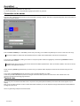
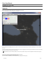
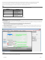
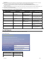
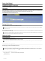
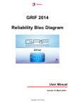
Execute LotAtc 4 DCS client and wait for the "Not connected" message to appear, then click on the [Connect] button of the main toolbar to
open the connection window:
Enter the server address (IP or URL/DNS), set the TCP port if using a non-default one (default port is 10310; LotAtc uses TCP only).
The server address is unique: the same address works for LotAtc and for DCS clients. One server to rule them all!
Then choose your coalition by clicking on the blue or red square (active coalition is highlighted), and enter the password needed to
access the chosen coalition.
Passwords are set by the server; ask the host what he set. Default password are: "blue" for the blue coalition, and "red" for the red
coalition; how original is that, huh?
Finally, enter the pseudo (login/nickname) you want to use (your pseudo will be displayed in the ATCs list and when using the chat
feature).
Then, click on the [Connect] button at the bottom of the connection window to go online.
LotAtc also provides a Bookmarks system for saving the connection data if you use the same server often. Please refer to the
[[LotAtc:Connection Bookmarks]] page about this.
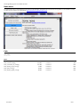
Tactical view
As soon as you're connected, if the DCS server is un-paused, the picture (tactical situation) and mission data should appear on your
display.
Now, you're an active controller: it's time to work! Remember that what you can see depends of the [[LotAtc:Detection Profiles|detection
profile]] set by the server.
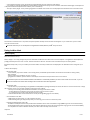
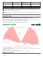
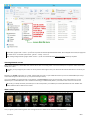
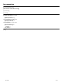
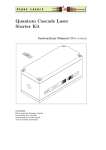
Here is a (quite busy) example of the tactical view:
12/17/2015
2/41
Above the background map (settings: see [[LotAtc:Maps]] page), you can see aircraft, airbases and ground emitters (radars). Refer to
next paragraph to discover the symbology displayed.
- The aircraft are seen because they're detected by an ally asset, such as an AWACS or EWR.
- The airbases are seen because everybody knows where they are.
- The ground units are seen if they are radar emitters: then our AWACS or EWR detects their emissions and triangulate their position;
LotAtc also display their own detection range based on a "threat library" (here, the DCS own database).
More details about who "sees" what and the different settings offered by LotAtc on the [[LotAtc:Detection Profiles]] page.
Symbology Overview
All examples in this paragraph are part of the tactical view shown above.
Example 1: Aircraft
Symbology
Aircraft.jpg
An aircraft is displayed in
LotAtc shows:
- A Symbol showing the aircraft
position and nature
As a controller, it's your job to
set the symbol used based on
the nature of the detected
aircraft (that you have to
"guess" from the tactical
situation); to do this, click on
the aircraft's symbol and
choose from the drop-down list
12/17/2015
Symbology Overview
Example 2: Airbases and
Allied Fighters
AirbasesFighters.jpg
- Airbases are displayed with
their 4-caracters codes, and a
base shematics (runways,
taxiways...) when you zoom in.
The color of the code depends
on the coalition of the base:
allied color (here: green) =
allied airbase; blue = neutral;
ennemy color (here: red) =
ennemy airbase.
Above two airbases are
displayed (UGKS: Senaki
Example 3: Ground radar
and Bandits
RadarBanditsNalchik.jpg
{TODO} (Az)
* radars
* ships
* circles
* labels
* bandits
3/41
of the properties dock.
Kolkhi and UGKO: Kutaisi);
The symbol set is automatically UGKS is allied, UGKO is
shared among allied
neutral.
controllers.
Allied airbases also have a
- A Velocity Vector showing the detection range displayed as a
aircraft heading and speed;
discontinued circle around
velocity vector lenghts can be them; this is where the
relative to time or pure speed, airbase's own approach radar
learn about this in the
sees. You can take control of
[[LotAtc:Options]] page.
an approach at allied airbases.
- A Label (and its link to the
- This example also shows 2
symbol); the label displays
allied fighters (notice the
various informations about the different symbol for the
aircraft.
previous example) with their
You can rotate the label around pilots nicknames.
the aircraft with LSHIFT+click They are climbing as shown by
or LCTRL+LSHIFT+click.
the upward-pointing arrows
You also have the ability to
next to their altitude (displayed
personnalize the label
in FL).
associated with aircraft, please
refer to the [[LotAtc:Labels]]
page to learn how to do this.
For a more comprehensive description of LotAtc's Symbology, please refer to the dedicated [[LotAtc:Symbology]] page.
My first control
{TODO} (Leb)
Tactical role (GCI/AWACS)
{TODO}
Approach role (GCA: Ground Controlled Approach)
{TODO}
Dock system
{TODO} + voir si ce § et le suivant ne devraient pas être regroupés sous un "chapeau" LotAtc's user interface ?
Main toolbar
{TODO}
Files
TacticalView.jpg
146 KB
02/15/2015
Azrayen
Aircraft.jpg
17.3 KB
02/15/2015
Azrayen
AirbasesFighters.jpg
21.4 KB
02/15/2015
Azrayen
RadarBanditsNalchik.jpg
22.4 KB
02/15/2015
Azrayen
ConnectionWindow.jpg
35.7 KB
02/24/2015
Azrayen
12/17/2015
4/41
Connection Bookmarks
This page is WIP for LotAtc v1.00
The Bookmarks system is for connecting LotAtc client to servers you regularly use, without re-typing all login informations each time.
Creating a Bookmark
To create a Bookmark, you need to type in all login informations then, instead of clicking on the [Connect] button:
1/ type a name for your Bookmark
2/ click on the [Bookmark current] button.
This will save the server address, the server port, the chosen coalition and its password, and your login/pseudo into a new Bookmark.
The Bookmark's name will allow you to quickly know which is which in the Bookmarks drop-down list.
Using a Bookmark
Really simple! Just select the desired Bookmark from the drop-down list: this will fill the required fields in the connection window; then click [Connect] and
that's it!
Deleting a Bookmark
If the server changes its settings (address, password...) of if you want to change your login/pseudo you'll have to create a new Bookmark.
We also advise you to delete old Bookmarks to avoid cluttering the drop-down list with obsolete Bookmark.
To delete a Bookmark, select it from the drop-down list and click on the [Delete current Bookmark] button. Please note that there is no confirmation
window, the Bookmark is "simply" and immediately deleted.
12/17/2015
5/41
Introduction
All the information you'll need to be able to use LotAtc 4 DCS is here.
This documentation made for 0.9.2 is currently in progress for 1.0.0 so some new features will appears, and some void pages can appear too
What is LotAtc?
LotAtc is a client + server software witch is connected with DCS World Simulator and provide users to get an ATC/CGI view of the battle. You can help
human pilots to accomplish their mission by radioing them a tactical view!
At this time, LotAtc 4 DCS is for DCS multiplayer only; as an ATC, you may radio your instructions & informations to pilots using a voice software such as
TeamSpeak, Mumble... etc.
LotAtc originally stands for "Lock-On tiny ATC" (back in 2006!) and later "Lock-On tactical Air Traffic Control" to emphasize the importance of the tactical
part.
The original name was retained for the current LotAtc 4 DCS version as it is well known by the online community.
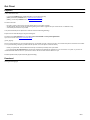
{{youtube(gCpPCjThfZE)}}
Feature list of current version and Roadmap
Kindly refer to the [[Features]] page.
How do I get LotAtc 4 DCS?
LotAtc 4 DCS Client application requires a license to be purchased. The licence costs €20.00 if you're an individual or a non-profit organization.
See the [[Get Client]] page for more information.
LotAtc 4 DCS Server application is free to use. You can get it here: [[Download]].
Need help?
Online documentation
Installation
- [[Client Installation guide]]
- [[Server Installation guide]]
User Guide
In general & for missions builders:
- [[Detection Profiles]]
For server:
- [[Server User Manual]]
- [[Server Configuration]]
- {{faq_server}}
For client:
- [[Client User Manual]]
- [[Languages|LotAtc Languages]]
- [[Client FAQ]]
More help?
- Use our Forum
12/17/2015
6/41
Client Installation guide
Buy a licence for LotAtc 4 DCS
Please see the [[Get Client]] page.
Installation
Installing the application
Note you don't need DCS World or any module to execute the LotAtc client, it's a stand-alone software !
After downloading the 32 or 64 bits installer (depending on your system configuration, if you do not know, take the 32bits it will work in all cases), execute
the "Setup_LotAtc4DCS_xxx_xxbits.exe" and follow the installation wizard.
During this step, you have to accept the end-user licence agreement and choose a destination folder for the installation of LotAtc 4 DCS.
Default path is C:\Program Files\LotAtc 4 DCS
LotAtc 4 DCS client will need:
- about 340MB of disk space for the client software itself, and
- an additionnal 330MB of disk space for the Relief database (terrain mesh, shared between LotAtc 4 DCS server and LotAtc 4 DCS client) put into
{UserHome}\LotAtc 4 DCS\Data\ folder.
Regarding the Relief database in your LotAtc 4 DCS client, LotAtc installer will ask you if you want to download & install it:
- If you already have installed LotAtc 4 DCS server (or intent to install it), you don't need to download & install the Relief database through the client
installer: the database is mandatory for the server, and is included in its installer. Untick the checkbox.
- If you have not installed LotAtc 4 DCS server (and don't intent to install it), you may choose:
- to take the Relief database, and get the elevation data of the mouse cursor point: tick the checkbox,
- or not to take it, and have elevation indicated as zero anywhere on the map: untick the checkbox.
Network authorization
LotAtc 4 DCS client communicates with LotAtc server through the (default) TCP 10310 port. Ensure to allow LotAtc 4 DCS client to use that port to reach
the server.
Refer to your firewall documentation for how to do that. Most firewalls will ask permission on the first launch.
Being a client-only application, LotAtc 4 DCS client doesn't need port forwarding (NAT) through your router. Only servers need to do that.
First launch, Demo mode & Licence key
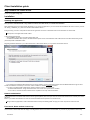
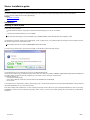
On first launch, LotAtc 4 DCS client will display a "Not Registered" mention at the bottom of the window, as you have not yet provided it a licence key:
12/17/2015
7/41
You can now either:
- Use LotAtc as it is, in demo mode (unregistered), in which you'll be limited to one connexion and 10' of use per execution of DCS/LotAtc server per
client.
- Or, if you've bought a licence, you should now copy/paste the lotatc.key file you received by e-mail following your [[Get Client|purchase]] (it can take
up to 24h) into your {UserHome}\LotAtc 4 DCS\Data\Client\ folder.
This folder should have been automatically created by the first launch of the newly installed application; alternatively, you may create it manually.
{UserHome} is your windows account personnal folder. If you have a default windows installation then:
- with Windows XP, {UserHome} is C:\Documents and Settings\{your_windows_username}\
- with Windows Vista or 7, {UserHome} is C:\Users\{your_windows_username}\
The next time(s) you'll launch LotAtc 4 DCS, you'll not get the "Not Registered" message anymore, and you'll be able to use the application without the
demo limitations.
Refer to the [[client user manual]] to see how to do this and have fun!
Uninstallation
Uninstalling LotAtc 4 DCS client is automatic. Execute the uninstaller via Windows start menu (or the .exe directly in the LotAtc client folder).
Please note that the uninstaller removes all files in the client installation directory, but will not delete the relief database, nor your licence key that are in
another folder. You may then uninstall and re-install LotAtc 4 DCS on the same computer without having to worry about the database or your licence.
12/17/2015
8/41
If you reinstall your system (Windows), don't forget to make a back-up of the licence key (e.g. keeping the mail, have a back-up copy...).
If for whatever reason, you want to remove this licence key file too: do it manually. If you do so, don't forget to save it elsewhere if it's your intention
to re-install LotAtc 4 DCS client later.
Problems/questions
See [[Client FAQ]]
Files
lotatc_relief.db_install.jpg
67 KB
11/17/2013
DArt
lotatc_not_registered.jpg
90 KB
11/17/2013
DArt
12/17/2015
9/41
Client User Manual
Installation & Licence key
See [[Client Installation Guide]]
Connection
Execute LotAtc 4 DCS client. After loading, a "Not connected" message will appear.
Click on the [Connect] button of the main menu bar, you'll get this:
Enter the address (IP or URL/DNS) of the server you want to connect to, set the TCP port if using a non-default one (default port is 10310; LotAtc uses
TCP only).
Choose your coalition by clicking on the blue or red square (active coalition is highlighted), then enter the password needed to access the chosen coalition
(passwords are set by the server; ask the host what he set).
Default password are: "blue" for the blue coalition, and "red" for the red coalition. And yes, we won an imagination contest with that (a long time
ago).
Finally, enter your Pseudonym (will be displayed when using the chat feature).
Then, click on the [Connect] button of the connection window.
Once the connection is established, you will be notified by LotAtc displaying the following things:
12/17/2015
10/41
- A non-persistent message saying "Connection and authentification OK" (top right of the radar display),
- Your pseudonym and the active [[Detection Profiles|detection profile]] at the top right of the main UI bar, and said bar will be lightly colored (the color
of the pseudo and the bar depends on the coalition you're connected to).
- The map is active ("bright" colors) and the geographical coordinates of the mouse cursor are dispayed in the bottom left corner of the radar screen.
Seconds later, if the DCS server is un-paused, the picture (tactical situation) and mission data should appear on your screen. Now, you're an active
controller: it's time to work!
Remember that what you can see depends of the [[Detection Profiles|detection profile]] set by the server.
Using LotAtc client
Radar display
What does LotAtc show up?
Well, it displays, over a map (background), the units detected in the DCS mission. Which units are shown depends on the [[Detection Profiles|detection
profile]] enforced by the server and, of course, the tactical situation at the time. The radar screen is refreshed every 2 seconds by default.
By default, friendly units (= from your coalition) are shown in white, and enemy coalition units are displayed in red. See below how to change that if you
wish.
LotAtc is able to display:
- Mission data, with:
- current weather (only if static weather - we're looking what's possible with dynamic weather, but at this time the answer is 'nothing useful')
- time from DCS
- bullseye position (your coalition's one only, of course)
- geographical coordinates, position relative to the bullseye, and elevation of the point at the mouse cursor location.
NB: elevation requires the relief database installed; this database is automatically installed if you have LotAtc 4 DCS server module, or you can
choose to download and install it when installing LotAtc 4 DCS client stand-alone application.
- Aircraft units, with:
- a symbol that may vary depending on the [[Detection Profiles|detection profile]] enforced by the server, the nature or mission of the aircraft, or simply
the controller's choice (you or another colleague logged on the same coalition),
- a velocity vector showing where the aircraft is headed for; the lenght of the vector is either:
- showing where the aircraft will be in X seconds if it doesn't change course nor speed
- or proportional to the aircraft ground speed measured by LotAtc,
- a customizable label with various data about the aircraft (see the [[Labels]] page for more details).
- Ground and Sea units, with:
- a SAM symbol for Ground units, or a ship symbol for Sea units,
- a label indicating their type, displayed only when you're hovering your mouse cursor above the symbol.
- Detection and Engagement circles, with:
- the detection circle (discontinuous line) that allows the ATC/GCI to assess units max detection range (AWACS, ground- and sea-based radars),
- the engagement (threat) circle (continuous line) that allows the ATC/GCI to assess units max engagement range (ground- and sea-based SAMs).
- You may hide those circles if needed to declutter your radar screen: See 'Key shortcuts' below.
Important:
12/17/2015
11/41
Above ARCADE profile, the engagement (threat) circle is displayed only if the launcher is the same vehicule as the radar. LotAtc simulates an ESM
capability, and you cannot know where precisely is a launcher if it doesn't emit radar waves.
Please refer to the [[Detection Profiles]] page to learn more about what types of SAMs (and their circles) are displayed or not, and why.
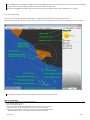
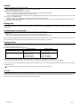
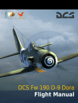
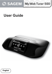
Let's see a simple example:
Here, we see an aircraft taking off from Sochi Adler RWY 24, a SAM protecting the airbase, and a ship loitering off the coast.
All the units are white, which is the default color for friendly units (ennemies are red by default); this means here they all belong to our side (our coalition).
On this image, the green texts and arrows are legends. Those do not actually show up in LotAtc.
Mouse commands
Your mouse is your most used tool in LotAtc 4 DCS. Use it to:
- Move the map: Left click + drag
- Zoom the map: Mouse wheel
- Display an aircraft's 'detailled' (hovered) label: Hover your mouse cursor over its label
- Display a ground or sea unit's type label: Hover your mouse cursor over its label
- Rotate an aircraft label by 45° increments around its radar plot (to declutter the display):
- Maintain [Shift] and Left click on the label or the aircraft symbol for clockwise
12/17/2015
12/41
- Maintain [Shift+Control] and Left click on the label or the aircraft symbol for anticlockwise
- Display and Set the properties (name, symbol) of a displayed unit: Left click on the unit then use the Properties panel on the right side of your display
(this is not available in ARCADE profile)
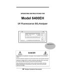
- Draw a bearing/range calculation line: Right click+drag
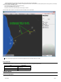
- Draw a persistent BRAA: Ctrl+right click
- Left click in mouse cursor data area (bottom left of map) to reduce it
About the latter feature, which is most useful for tactical controllers, here is how it looks:
Again, on this image, the green texts and arrows are legends and do not actually show up in LotAtc.
Key shortcuts
Key shortcuts allow controllers to change some settings instantly, without having to dig into the option menu:
Key
Alt+N
Alt+C
Alt+L
Description
Change unit system
metric/imperial
Show/hide detection/threat circles
Show/hide labels background
Options Menu
General (Languages)
12/17/2015
13/41
This is where you'll choose what language LotAtc 4 DCS should use. Restarting LotAtc is mandatory for any change made here to be applied.
Thanks to volunteer members of the community, several languages are now available for LotAtc 4 DCS client. Thanks to all involved!
Please refer to the [[Languages]] page for more details, including the list of available languages at this time.
Map
The map option menu allows you to choose which map is used as a background for LotAtc 4 DCS radar display.
You may choose between four maps:
Map name
Description
classic
default map; it shows land/sea,
main lakes and urban areas
simple
same as the default one, but
without urban areas
green
same as the simple one, but land is
green instead of dark grey
relief
(new in 0.9.0): it shows the relief of
the terrain, the main lakes/rivers,
and states borders
LotAtc is built to allow more maps to be easily included. This will be documented later.
Items
The items option menu allows you to set LotAtc symbology principles.
Here you'll be able to:
- cycle between the "AWACS" and the "French" sets of symbols (to display different aircraft/missions) (see [[Detection Profiles]] for more details about
available individual symbols)
- set the colors you want to use for friendly and enemy units (defaults are: Friendly = White / Enemy = Red)
- set the size of the symbols (change it if symbols are too tiny to be read on your screen; default size is 15)
- configure how you want the aircraft speed vectors to be displayed between:
- the zoom independent mode (slider fully to the left), where the speed vector lenght is relative to the measured ground speed of the aircraft, and
independent of the zoom of the map
- the time mode, where the far end of the speed vector shows where the aircraft will be in X seconds (set X with the slider); by nature, the speed
vector lenght then varies depending on the zoom level.
Labels
This option allows you to set what data the aircraft labels will display.
12/17/2015
14/41
See the [[Labels]] page for more details about this.
News menu
The [news] button opens a window displaying last news from the developper. There will be announced the version upgrades (no auto-updater for LotAtc).
The news are also visible on the LotAtc website: http://lotatc.dartsite.org/projects/lotatc/news
FAQ
{{faq_client}}
Files
lotatc_news.jpg
98.8 KB
04/21/2013
Azrayen
lotatc_connect_0.9.0.jpg
82.6 KB
11/17/2013
DArt
lotatc_connection_OK_0.9.0.jpg
65.7 KB
11/17/2013
DArt
lotatc_bearing_range_0.9.0.jpg
114 KB
11/17/2013
DArt
lotatc_items_0.9.0.jpg
122 KB
11/17/2013
DArt
lotatc_display_legend_0.9.0.jpg
185 KB
11/17/2013
DArt
12/17/2015
15/41
Labels
Ground units and Ships labels are not customizable:
- They are displayed only when you hover your mouse cursor above the unit
- They only display the type of the unit.
Aircraft labels, on the other hand, are very customizable:
- Each user (controller) may say which data he wants to be displayed, and in what order/presentation
- There are independent settings for friendly and ennemy aircraft
- There are independent settings for both the normal mode (displayed by default) and the hovered mode (when you put your mouse cursor above the
label, to get more (or different) data).
- The data themselves are automatically shared among the controllers of the same coalition.
- Whenever a data value is updated by a controller (e.g. the name or symbol used for an aircraft), all his "colleagues" will get the information at the
next refresh of their own radar display.
Background
You can choose to display or not the background of the label. This can be changed using the Alt+L key of your keyboard, in LotAtc's main view, or in the
options menu.
Rotate labels around aircraft
To declutter the labels, you can rotate the label around the symbol with 45° angle increments.
To do this, use:
- [Shift] + left-click either on the aircraft symbol, or on its label to rotate the label clockwise
- [Ctrl] + [Shift] + left-click either on the aircraft symbol, or on its label to rotate the label anticlockwise.
Beyond that manual setting, the labels will keep their positions relatively to the aircraft vector: If you put the label of a southbound plane on its left, then if
this aircraft turns and heads north, the label will accompany the move and be displayed on its right side.
Displayed Data
Labels have two states: normal and hovered. The hovered state is shown only when you place the mouse cursor over the label; when you're not doing this,
the label will display the normal version.
By default, the labels will display the following data:
Friendly aircraft
Ennemy aircraft
Normal state
Callsign (up to 10 characters)
TN# (up to 10 characters)
Altitude (short format)
Altitude (short format)
Hovered state
Callsign
TN#
Altitude (long format)
Altitude (long format)
Type & Ground speed
Type & Ground speed
Position (from Bullseye)
Position (from Bullseye)
Most of the time, you'll want to keep the "normal" label as short as possible, to avoid cluttering your radar display.
The hovered state label will then allow you to know more about a specific aircraft, by pointing your mouse cursor at it specifically.
You may set what data the labels will display, by replacing the default text by yours. You may set independantly the normal and hovered state, for friendly
and ennemy aircraft.
Your settings are automatically saved, and will be re-used the next time you'll use LotAtc 4 DCS.
Example
The bandit aircraft (TN#6) and the first of two GAI fighters climbing to intercept it ("Guardian 51") display normal labels with only the callsign/TN# and the
altitude (short format); meanwhile, the controller hovered its mouse cursor above the second GAI fighter label ("Guardian 52"), which then dispays the
hovered state, with more data: aircraft type, speed, position from the bullseye.
12/17/2015
16/41
Available Attributes table
The following table lists the available attributes in LotAtc 4 DCS. When you set an attribute, LotAtc will display the value for this attribute, in the context of
the mission.
Examples are provided for a better comprehension:
Attribute
Name
Description
Example
friendly
%(name)
Unit Name (or TN)
%(group_name)
Group Name (if available)
%(type)
Unit Type
%(heading)
Heading
%(alti_long)
Altitude long format
%(alti_short)
Altitude short format
%(vert_indic)
Vertical indicator
%(gs)
Ground Speed
%(gs_short)
Ground Speed in short
format
%(gs_unit)
Ground Speed Unit
%(posit_bulls)
Position to BullsEye
Shows the aircraft's pilot
DArt
name or the radar track
number allocated to this
aircraft [[Labels#Notes
about the aircraft's pilot
Name attribute|See notes]]
Shows the aircraft's group Shark
name if available
Shows the aircraft unit type A-10C
(or UNK for unknown if
ennemy)
ennemy
TN#1532
UNK
metric
12/17/2015
Shows the aircraft heading
(true heading) use
true/mag/truemag option
for true/magnetic deviation
correction (default is auto)
Shows the aircraft altitude
in long format (including
unit)
Shows the aircraft altitude
in short format
Displays an arrow showing
if the aircraft is climbing,
descending or [optionnal]
stable [[Labels#Note about
the Vertical Indicator|See
notes]]
Shows the aircraft
GroundSpeed (only the
numeric value)
Shows the aircraft
GroundSpeed (only the
numeric value with 2
numbers only (no unit
represented)
Shows the unit of the
aircraft GroundSpeed
Shows the unit's
imperial
015°T
015°T
2300m
7500ft
2.3
075
➚ ➘ [➙]
543
250
54
25
km/h
kt
B090°/63km
B172°/203Nm
17/41
heading/distance relative to
the coalition's BullsEye
Notes about the aircraft's pilot Name attribute
The aircraft's pilot name is from DCS mission editor for IA-piloted aircraft, and from MP login name for Human-piloted aircraft.
You can "trim" the value of the %(name) attribute using this syntax: %(name|3)
This will display only the firt 3 characters of the name. You may change the max number of characters at will.
The Name will be replaced by the Track Number for ennemy aircraft in Basic and Realistic [[detection profile|Profiles]]. See below for details.
Note about the Radar Track Number
Aircraft from your coalition are deemed cooperative in LotAtc 4 DCS: you can display their (pilot's) name/callsign and (aircraft) type, allegedly known via
IFF system (even if IFF system is not modelised into DCS World, for now).
On the other hand, ennemy aircraft won't cooperate and let you know who they are! Your radar systems will detect them, you'll know that there is an
aircraft here, you'll be able to measure its altitude and speed, but your radar won't be able to know who/what it is.
To avoid confusion, it's useful to have a unique "ID" as a reference for each (ennemy) aircraft. For this purpose, LotAtc uses Radar Track Numbers.
A Radar Track Number (or TN for short) is a unique ID on 4 digits that the radar system of an AWACS aircraft automatically allocate to each new
(airborne) radar track it detects.
LotAtc 4 DCS simulates the automatic allocation of a Radar Track Number, and uses it in place of the aircraft's pilot "name" when it doesn't have another
(real) name to use, so that it is displayed as part of aircraft labels (it will show the number with the prefix "TN#").
Typically, this Radar Track Number will be displayed for ennemy aircraft in BASIC and REALISTIC profiles.
It will allow a better SA and/or coordination between different controllers. The controllers can change the "name" of the aircraft at will (be it a pilot's name or
an allocated Track Number) and this information is automatically shared among controllers of the same coalition.
Please note that the persistent or temporary characteristic of the Radar Track Numbers depends on the [[detection profile]] setting (set by the server).
This TN system, the values it uses, and the persistent / temporary characteristic of the allocated TNs is still WIP in the 0.9.0 version of
LotAtc. Please refer to the [[detection profiles]] page for more details.
Note about the Vertical Indicator
You can use customize the vertical indicator:
Characters used
Different arrow character can be used try: %(vert_indic|n) with n between 0 (default) to 2
Do not display stable value
If you do not want to display stable indicator (only up and down) use %(vert_indic|nostable)
You can mix the differents options: %(vert_indic|1|nostable)
Files
lotatc_labels.jpg
15.8 KB
05/12/2013
Azrayen
lotatc_labels_0.9.0.jpg
23.7 KB
11/17/2013
DArt
12/17/2015
18/41
Languages
Thanks to volunteer members of the community, several languages are now available for LotAtc 4 DCS client. Thanks to all involved!
Language
English
Français
Deutsch
Italiano
Polski
Ceština
Português
Srpski
Español
Svenska
12/17/2015
Table of the languages available (or soon to be available) in LotAtc 4 DCS client
Language (EN)
Translator(s)
Status
English
DArt
Fully Implemented
French
DArt
Fully Implemented
German
Supersheep
Fully Implemented
Italian
AMVI_Flanker
Fully Implemented
Polish
ptako
Fully Implemented
Czech
Suchacz
Partially Implemented
Portuguese
hguimaraes
Fully Implemented
Serbian
ArcticSilence/Sova
Fully Implemented
Spanish
Francis
In progress for 1.0.0
Chinese
uboats
In progress for 1.0.0
Russian
Edrussia
In progress for 1.0.0
Swedish
Dejjvid
In progress for 1.0.0
19/41
Detection Profiles
LotAtc features five "Detection Profiles". The server chooses a profile, that is then enforced for all its LotAtc clients (from both coalitions).
The profile sets what clients ATCs will see or not see on their radar displays, and what functionnalities will be available to them.
Actually, LotAtc server knows everything that goes onto the mission. So technically, profiles are sets of 'filters', from the less to the more restrictive,
applied to data send to (hence displayed by) LotAtc clients.
Definitions
Detection area
Units equipped with a surveillance radar in DCS have a pre-determined detection area. This area sets "where" the unit can "see" others using its radar.
To implement detection areas (range & characteristics), LotAtc 4 DCS uses the needed values directly from DCS own database.
This allows LotAtc 4 DCS to manage fluently new units added to DCS World, and keeps the DCS+LotAtc system logical.
Depending on which Detection Profile is set, detection areas may however vary. Please see the description of each Profile below for more details.
The relevant units are:
- AEWs aircraft (also known as AWACS) such as the E-3 Sentry, the E-2 Hawkeye and the A-50 Mainstay.
- EWRs on the ground.
- Medium and Long Range SAMs units.
- Radar-equipped warships such as CVs, CVNs, CGs, CGNs, DDs, FFs, FFLs, FFG, FSGs... etc.
Those units should be "alive" to have a valid detection area. In other words, if a unit is killed during a mission, then the informations its radar provided to
LotAtc is lost.
Short range radars, with a detection range of 5,000m or less (based on DCS data) are not taken into account: We consider that only bigger radars are
likely to be used by controllers who provide guidance to aircraft.
Radar Coverage
In some of the profiles described below, the notion of radar coverage is used.
Your radar coverage is the sum of the detection areas of each of your coalition radars assets (provided their detection range is > 5,000m, based on DCS
data). Indeed, LotAtc 4 DCS condiders that those radar assets work as part of a datalinked network, and that as a controller you'll be able to see the whole
picture.
LotAtc cannot know - at this time - the status (operating/not operating) of the radars. Hence those radars are always considered as active in LotAtc,
and always contribute to their coalition radar coverage, except for AWACS that are considered "active" only when above 50 kts (~ 93 km/h) ground
speed; this prevents the AWACS to "see" anything when taxying, which would be unrealistic (not to mention the dangerousness for the unlucky
engineers around ^^). We're aware all this is not so cool, and we'll try to remove this current limitation as soon as possible.
LotAtc client displays the radar coverage via the detection circles of each of your radar assets. The sum of all circled areas (on your side) is your
approximate horizontal radar coverage.
Aircraft's RCS is not taken into account for now. The notion of being inside or outside the radar coverage is a On/Off choice at this time.
The ARCADE profile
The Arcade profile meets two philosophies :
- Being kind of a "god's eye" (or "cheat") mode which sees the whole tactical situation, whithout limitation.
- Being super-easy to use i.e. not all functionnalities or options are there.
This profile is intended for beginners or those who don't care so much about "realism". It may also be used to stream a full tactical situation to spectators,
12/17/2015
20/41
for people organizing ~live events.
Units displayed in Arcade profile
LotAtc diplays all aircraft, ships and ground units (blue & red, airborne & on the ground, even the simple private) on their radar displays, regardless of your
coalition or its actual detection capabilities (aka radar coverage).
The only "units" you won't see on your LotAtc display in Arcade profile are the weapons (missiles of all types, bombs, gun rounds...) that can "fly" but are
definitely not considered as aircraft.
Symbology & identification of units in Arcade profile
Aircraft symbology is quite simple: one symbol and color for allied aircraft, another symbol and color for ennemy aircraft. That's all.
Identification of the pilot's name is provided for all aircraft from both coalitions.
Identification of the unit's type is provided for all units (aircraft, ground units, boats) from both coalitions.
All those data are automatically provided by LotAtc, from DCS mission data, and cannot be changed within LotAtc in Arcade profile.
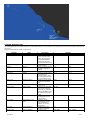
The BASIC profile
The Basic profile philosophy is to provide a narrower view of the tactical situation than does the "magical" arcade profile, and at the same time to help
controllers with as much automation as possible. It's intended to be nice to play with, but not too hard to manage for people who want a casual experience
about controlling missions.
It introduces a simplified version of the detection area for each surveillance radar equipped unit. We call this simplified version the "Spherical Radar".
It's based on range only: each radar unit detection area is a sphere, the center of which is the radar location. The sphere is drawn from the max range value
for this radar, as set by the DCS database.
The Spherical Radar limits LotAtc visibility for aircraft only: Ground and Sea targets may be displayed (if they match criteria) wherever they're on the map
in Basic Profile. This "simulate" a full map ESM capability.
The Basic profile also come with three important filters. The first two restrict the ability of your radars to see aircraft, while the third one affects your visibility
of ground and sea units:
Units affected
Filter based on
Aircraft
Speed
Aircraft
Terrain
Ground/Sea units
Unit's radar capability
Description
This prevents aircraft flying to slow
to be displayed by LotAtc. This
allows to declutter controllers
display by not showing aircraft on
the ground.
This prevents aircraft that hide in
the relief (terrain masking) to be
displayed by LotAtc.
LotAtc simulates an "ESM"
capability, meaning that such units
which will be detected only if they
emits a (powerful enough) radar
signal.
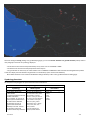
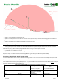
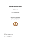
The following diagram summarizes the visibility obtained with the Basic profile:
12/17/2015
21/41
- Airplanes 1 & 2 and helicopter 5 are displayed by LotAtc.
- Airplane 3 is not displayed, even if it flies at the same "horizontal" distance (from the radar) as airplane 2, because being higher it is outside the max
range bubble.
- Airplane 4 and helicopter 6 are not displayed, because they're masked by the terrain.
Units displayed in Basic profile
LotAtc displays:
- all aircraft that:
- have a ground speed > 50 kt for airplanes, and > 25 kt for helicopters. The lower speed for helicopters was introduced to take into account the
doppler effect of a rotor as seen by a radar, that helps said radar to detect and classify a chopper even at lower speeds.
- are "seen" by any of your radar assets (taking into account the spherical range of each radar) and the terrain masks in mountainous areas.
- all ground & sea units (anywhere on the map) that:
- possess a radar which detection max range is strictly greater than 5,000m (based on DCS data).
What does this mean? Well, that means that you won't see a taxying aircraft, nor a hovering helicopter; you won't see cargo ships, APCs or MBTs either
(they have no radar), nor a Shilka for example (it has not enough detection range in DCS, report to DCS encyclopaedia if needed).
Symbology & identification of units in Basic profile
The Basic Profile allows the controllers to use the full extent of the existing symbols in LotAtc 4 DCS. Each controller has the ability to change any aircraft
symbol. The assigned symbol is shared among all controllers of the same coalition.
The Basic Profile also aims to help the controllers by automatically assigning certain symbols to certain aircraft (at first detection). Doing this, the software
kind of simulates tasks that are mostly done by radar operators IRL. This part is still WIP in 0.9.0, the table below shows where we are for now on this topic
(last column), be aware this will be enhanced in the future.
Relevant coalition:
Allies or Ennemies
Allies
Allies
Allies
12/17/2015
Table of the 9 symbols available for aircraft in LotAtc 4 DCS 0.9.x Basic Profile
Symbol name:
Symbol to use for:
Automatically assigned in 0.9.0
for:
Unknown
New contacts for which the
All aircraft except for AEWs (both
controller has not specific
sides) and allied Helicopters
information
General - Civilian
Civilian (non-threatening) flights,
none (WIP)
military freighter under civilian
flight rules...
Helicopter
Allied Helicopters
Allied helicopters
Strike - Support
Allied Bombers (AI, CAS...),
none (WIP)
22/41
Allies
Fighter
Allies
AEW - HVA
Ennemies
Ennemies
Ennemies
Zombie
Bandit
Hostile
Tankers, ASW aircraft...
Allied Fighters in CAP/Air Defense
mission
Allied High Value Assets such as
AEWs, VIP transport... protect them
well!
Suspect or Rogue Civilian aircraft
Ennemy military aircraft
Ennemy aircraft to be shot down
none (WIP)
Allied AEWs
none - @ controller's discretion
Ennemy AEWs
none (WIP)
Note about the "Helicopter" symbol: IRL, it's used fort allied choppers only. A specific symbol for helicopters does not exist in the "French" set of
symbols; hence if you choose "Helicopter" with the "French" set, you'll visually get the same symbol as General - Civilian. This is not a bug, this is a
feature /plugin_assets/redmine_wiki_extensions/images/wink.png
Note about the "Zombie" symbol: Its use could be extended to (all) civilian aircraft from the ennemy coalition: in DCS, there is no real "neutral" or
civilian side.
The REALISTIC profile
The Realistic profile represents our best effort to make it feel real. You can't "see" aircraft outside your radar coverage.
The same rule applies for ground and sea targets: we decided to simulate the ESM coverage as equivalent to the radar coverage.
What's more is that your radar coverage uses what we call the "Full Radar" modelisation, meaning that radar limitations in azimuth and elevation are
taken into account. That means for example that an AWACS can't see just above nor just under itself.
As for other values, azimuth and elevation limits applied by LotAtc are directly read from the DCS database.
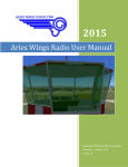
The following diagram summarizes the visibility obtained against air targets with the Realistic profile:
- Airplane 1 is not displayed, because it is above the upper elevation limit of the radar scan zone (aka "blind cone").
- Airplane 2 is displayed by LotAtc.
- Airplane 3 is not displayed, even if it flies at the same "horizontal" distance (from the radar) as airplane 2, because being higher it is outside the max
range bubble.
- Airplane 4 is not displayed, because it is masked by the terrain.
- Helicopters 5 and 6 are not displayed, because they're under the lower elevation limit of the radar scan zone.
Units displayed in Realistic profile
LotAtc displays:
12/17/2015
23/41
- all aircraft that:
- have a ground speed > 50 kt for airplanes, and > 25 kt for helicopters. The lower speed for helicopters was introduced to take into account the
doppler effect of a rotor as seen by a radar, that helps said radar to detect and classify a chopper even at lower speeds.
This declutters the displays at airbases, for aircraft on the ground. This also makes hovering helicopters disappear.
- are "seen" by any of your radar assets (taking into account the Full Radar modelisation) and the terrain masks in mountainous areas.
- all ground & sea units that:
- possess a radar which detection max range is strictly greater than 5,000m (based on DCS data). Reminder: we simulate an ESM capability, not an
Air-to-Ground radar. That explains why we did this.
- are "seen" by any of your radar assets (taking into account the Full Radar modelisation) and the terrain masks in mountainous areas.
Symbology & identification of units in Realistic profile
Relevant coalition:
Allies or Ennemies
Allies
Allies
Allies
Allies
Allies
Ennemies
Ennemies
Ennemies
Table of the 9 symbols available for aircraft in LotAtc 4 DCS 0.9.x Realistic Profile
Symbol name:
Symbol to use for:
Remarks:
Unknown
New contacts for which the
LotAtc uses this one for each new
controller has not specific
contact except Allied AEWs
information
General - Civilian
Civilian flights, military freighter
under civilian flight rules...
Helicopter
Allied Helicopters
No specific symbol exists for helos
in "French" set: General - Civilian
symbol is displayed instead
Strike - Support
Allied Bombers (AI, CAS...),
Tankers, ASW aircraft...
Fighter
Allied Fighters in CAP/Air Defense Do not use this for fighter/bombers
mission
in ground attack missions
AEW - HVA
Allied High Value Assets such as
Your AEWs will get this symbol
AEWs, VIP transport...
automatically; that's the only
automatisation in Realistic profile
Zombie
Suspect or Rogue Civilian aircraft As there is no real "civilian" side in
DCS, this may be use to all ennemy
transports
Bandit
Ennemy military aircraft
Including ennemy AEWs
Hostile
Ennemy aircraft to be shot down
Example: aircraft whose behavior
leads you to classify them as
fighters threatening
The CUSTOM profile
By chosing this profile, you can adjust LotAtc options to customize how you want to use LotAtc
Here the differents options:
Options
Display enemies parameters
Display enemy SAM & Ships even
outside of own radar coverage
12/17/2015
Description
show/hide enemies parameters like
its name, the type (ex: Su27), its
callsign
If true, client will see SAM and
ships of the other coalition even if
24/41
Use low speed filter
Use relief
Automatic type
Radar modelisation
Approach mode on airport
they are outside its radar coverage
if true, planes and helicopter with
low speed will be filtered
If true, LotAtc will use the relief to
decide if a contact is seen, if false,
LotAtc will live in a plate world,
without mountains
For a new contact, system will
apply the correct symbole
depending of its type (AWACS,
fighter...) otherwise it will be unknow
type
- For all (enemies and friendly)
- Only for friends (friendly only)
- Disable ( for nobody )
LotAtc can use different radar
modelisation (simple and fast to
more complex)
- See all (radar coverage are
infinite, you see everything)
- Cylinder (radar are cylinder with
infinite altitude)
- Spherical (radar are perfectly
spherical)
- Conical (radar are spherical but
has blind cone generally on top and
bottom, values come from DCS
World)
Choose who can control and which
airport can be controlled
- None (no control on any airport)
- Own coalition airports only ( can
control only airports in its coalition)
- All airports ( can control all
airports )
The MISSION profile
When saving a mission file in mission editor, DCS save current LotAtc options in the miz file (all options are concerned, enable, profile, options...). By
settings this profile in the DCS server, LotAtc will used the LotAtc options found in the miz.
Files
Basic_Profile.jpg
59.8 KB
11/17/2013
DArt
Realistic_Profile.jpg
78.6 KB
11/17/2013
DArt
picture996-1.png
27.9 KB
02/10/2015
DArt
picture996-2.png
121 KB
02/10/2015
DArt
12/17/2015
25/41
Download
For DCS 1.2.16 : Current version is: 1.0.0-rc2 (see archives below)
warning. For DCS 1.5 : Current version is: 1.0.0-rc3
warning. For DCS 2.0 : I work on it, I will publish a compatible version ASAP
CLIENT DOES NOT WORK ON WIN XP
Server
{FREE} Server is free to use!
ONLY FOR DCS 1.5.X ( For DCS 1.2.16 see 1.0.0-rc2 in archives below, for DCS 2.0, I work on it, I will publish a compatible version ASAP)
For DCS World 64 bits:
- Server LotAtc4DCS 1.0.0-rc3 - 64 bits [EXE]
- Server LotAtc4DCS 1.0.0-rc3 - 64 bits [JSGME]
- You will need to install this file for JSGME Mod version: relief.db and put it in your {Users}\LotAtc 4 DCS Data\ directory. (ex: C:\Users\DArt\LotAtc 4
DCS Data\relief.db)
See [[Server Installation guide]] for help
Client
Client needs a license, if you do not have one: [[Get Client]]
{FREE} Without it, you can run it as demo version, limitations are:
- 10 minutes until disconnection
- Only one connection by LotAtc DCS session (to be able to reconnect, you must relaunch a mission on the DCS host)
Links:
- LotAtc4DCS 1.0.0-rc3 - 32 bits
- LotAtc4DCS 1.0.0-rc3 - 64 bits
See [[Client Installation guide]] for help
Known problems
- COMPATIBLE with OpenBeta 1.5.1, as OB is not yet stable, next version is not garantee to work
- CHAT (and BRAA sent to pilots) does not work yet, it will come soon
- All airports are neutral, known bug, will be fixed soon too
Archives
Previous versions :
- 1.0.0-rc2 LAST VERSION FOR DCS < 1.5 !!!!
- Server :
- Setup_LotAtc_4_DCS_Server_1.0.0-rc2_64bits.exe
- JSGME Mod_1.0.0-rc2
- Client:
- Setup_LotAtc_4_DCS_1.0.0-rc2_32bits.exe
- Setup_LotAtc_4_DCS_1.0.0-rc2_64bits.exe
- 0.9.2
- Server :
- Setup_LotAtc_4_DCS_Server_0.9.2_64bits.exe
- JSGME Mod_0.9.2
- Client:
- Setup_LotAtc_4_DCS_0.9.2_32bits.exe
- Setup_LotAtc_4_DCS_0.9.2_64bits.exe
- 0.9.1-3
- Server :
- Setup_LotAtc_4_DCS_Server_0.9.1-3_64bits.exe
- JSGME Mod_0.9.1-3
- Client:
- Setup_LotAtc_4_DCS_0.9.1-3_32bits.exe
- Setup_LotAtc_4_DCS_0.9.1-1364bits.exe
- 0.9.1-1
- Server :
- Setup_LotAtc_4_DCS_Server_0.9.1_64bits.exe
- JSGME Mod_0.9.1
- Client:
- Setup_LotAtc_4_DCS_0.9.1-1_32bits.exe
12/17/2015
26/41
- Setup_LotAtc_4_DCS_0.9.1-1_64bits.exe
- 0.9.0
- Server : Setup_LotAtc_4_DCS_Server_0.9.0_64bits.exe
- Client:
- Setup_LotAtc_4_DCS_0.9.0_32bits.exe
- Setup_LotAtc_4_DCS_0.9.0_64bits.exe
- 0.8.2
- Server: Setup_LotAtc_4_DCS_Server_0.8.2_64bits.exe
- Client
- Setup_LotAtc_4_DCS_0.8.2_32bits.exe
- Setup_LotAtc_4_DCS_0.8.2_64bits.exe
- 0.8.1
- Server: Setup_LotAtc_4_DCS_Server_0.8.1_64bits.exe
- Client
- Setup_LotAtc_4_DCS_0.8.1_32bits.exe
- Setup_LotAtc_4_DCS_0.8.1_64bits.exe
- 0.8.0
- Server: Setup_LotAtc_4_DCS_Server_0.8.0_64bits.exe
- Client
- Setup_LotAtc_4_DCS_0.8.0_32bits.exe
- Setup_LotAtc_4_DCS_0.8.0_64bits.exe
12/17/2015
27/41
Download OpenBeta
{BETA}
ONLY COMPATIBLE WITH DCS > 1.2.8-RC2
Current version is: 0.9.1-3
Be careful, the 0.9.1-3 client needs a >=0.9.1 server (not compatible with previous version)
CLIENT DOES NOT WORK ON WIN XP
Server
Server is free to use!
- For DCS World 64 bits:
- Setup_LotAtc_4_DCS_Server_0.9.1-3_64bits.exe
- JSGME Mod
- You will need to install this file for JSGME Mod version: relief.db and put it in you {Users}\LotAtc 4 DCS Data\ directory. (ex: C:\Users\DArt\LotAtc
4 DCS Data\relief.db)
See [[Server Installation guide]] for help
Client
Client needs a license, if you do not have one: [[Get Client]]
Without it, you can run it as demo version, limitations are:
- 10 minutes until disconnection
- Only one connection by LotAtc DCS session (to be able to reconnect, you must relaunch a mission on the DCS host)
Links:
- Setup_LotAtc_4_DCS_0.9.1-3_32bits.exe
- Setup_LotAtc_4_DCS_0.9.1-3_64bits.exe
See [[Client Installation guide]] for help
12/17/2015
28/41
Features
This page describes the features of the current version of LotAtc 4 DCS, and a roadmap of what is coming next. Note that the roadmap could change...
Current version: 1.0.0
Features of current version
Server:
-
Integration "into" DCS World, as a free module
Low hardware ressources needs = low/none FPS impact for the DCS host
Manages several [[Detection Profiles|detection profiles]]
Manages authentification of controllers (LotAtc clients)
Filters implemented (used or not depending on [[Detection Profiles]] configuration):
- Speed (removes aircraft units under minimal speed)
- Radar (removes all units not in the coalition radar coverage). The radar coverage is the sum of individual radars areas (aka detection range).
- Relief. This allow LotAtc to manage terrain masking. [new in 0.9.0]
- The Radar filter is spherical (range in 3D) and follows DCS specifications. [new in 0.9.0]
- Reduced latency networking between server/client [new in 0.8.1]
- Built-in support of mission (re)loading without the need to restart DCS server [new in 0.8.1]
Client:
- Installation as a stand alone application (no need for DCS). Client needs a licence, buy it here: [[Get Client]]
- Client may be tested before purchase with the demo mode (10' of play). [new in 0.9.0]
- Application is localization-ready. English and French languages included since 0.8.0, and 6 new [[Languages]] added in 0.9.0.
- Includes several maps. A map showing the relief is added in 0.9.0
- Includes airports runways
- Manage coalitions (IFF): self is white, enemy is red
- Ability to change colors of coalitions [new in 0.9.0]
- Automatic assignation of a unique track number ("TN#") for enemy aircraft, allowing controllers to identify them when communicating
- Ability to change the default name (or TN#) of aircraft; changes are automatically shared among controllers of your coalition [new in 0.9.0]
- Controllers can set the symbol used for displaying aircraft (to precise their classification, e.g. friendly liner/ transport, friendly fighter, unknown,
hostile... etc.). Symbols are shared among clients (controllers) of the same coalition. This feature is available depending on the Detection Profile (i.e. not in
ARCADE). [new in 0.9.0]
- Two different sets of symbols available. [new in 0.9.0]
- Displays customisable [[Labels|labels]] for aircraft
- Able to display sea & ground units that meet the detection criteria (criteria depending on the detection profile). [new in 0.9.0: has_a_radar criteria now
taken into account]
- Able to display detection/threat ranges (circles) (+option: mask them) for sea & ground units, and AWACS
- Clients are able to display DCS mission data: time, weather (if static), Bullseye... [new in 0.9.0]
- Clients are able to display the [[Detection Profiles|detection profile]] enforced by the server. [new in 0.9.0]
- Fix for network code: no more freezes or lack of picture [new in 0.8.2]
- Chat will be implemented; this feature will allow controllers to text-chat between themselves, for a better coordination in complex scenarii [new in 0.9.1]
- Controllers will be able to manage their own Altitude & Speed filters (those will act in addition to the server-enforced filters).[new in 0.9.1]
- Client will be able to create persistent & hookable BRAAs; this means those BRAAs (Bearing Range Altitude Aspect measurement) will stay displayed
until manually removed, and will "follow" the objets onto which they're hooked.[new in 0.9.1]
- Drawings: Controllers are able to create, modify and share drawings (lines, shapes, points, texts...) onto their displays; this will allow them to share
information with better accuracy (e.g. a point of interest), or to manage combat zones with different RoE...
- Client are able to display the last known positions of an aircraft, as a "trail"; this help controllers to visualize aircraft trajectories.
- Airport mode with ILS approachs and complete taxiways, allowing controllers to fulfill the APP/DEP, TWR and GND roles.
12/17/2015
29/41
Get Client
Payment
LotAtc client license costs:
- (1-4 licenses) 20 Euros each (ca $25 depending of current exchange rate).
- {NEW} (5-9 licenses) 15 Euros each (-> please contact me before )
- {NEW} (+10 licenses) 10 Euros each (-> please contact me before )
The licence includes:
- the right to use the current version of LotAtc 4 DCS client on one unique computer,
- all next bugfixes releases and the next [[features]] listed (you'll be able to upgrade with your current licence, no additional costs),
- and certainly other features not yet listed.
Your purchase will help me to spend time to enhance LotAtc and add new [[features]]!
Payment can be made with Paypal, using the following link.
The license is for one computer and is only valid if you're an individual or a non-profit organization.
If your are not in this case, please contact me directly
{{lotatc_paypal}}
As it is a manual operation for me to send the license key, it could take up to 24h. I am living in UTC+1 zone. If 24h have passed, check this forum if there
is not a post describing a temporary problem with the operation. If not, then please contact me directly
- Check your spam folder, the email with the license key is sometimes put directly in the spam folder.
- If you register with an hotmail email, the server trash sometimes the email without notification for you or email error on my side... If you have not
received the email within the 24 hours, just send me a email, I will use another method to deliver it to you.
Problems/questions with payment? See the [[Payment FAQ]].
Download
Go the [[download]] page.
12/17/2015
30/41
Why is payment in Euro?
As a I am French, I prefer to use my currency as a reference. However, with Paypal, it will automatically convert the price in your currency using current
exchange rate. That means that in other currency like US Dollars, LotAtc price may vary with exchange rate.
I have paid with Paypal, but I have not received my license key ?
As it is a manual operation for me to send the license key, it could take up to 24h. I am living in UTC+1 zone.
If 24h have passed, check this forum if there is not a post describing a temporary problem with the operation. If not, then please contact me directly
I would not use Paypal but I want to buy a license
Paypal is a very secure way to make a transaction, for you and for me.
Anyway, if you do not want to use it, please contact me directly so we can work out an arrangement.
12/17/2015
31/41
Server Configuration
1.0.0 only
Configuration file
You can configure LotAtc Server within the config.lua file. It is located in your {UserHome}/Saved Games/DCS/mods/tech/lotatc/config.lua
Use Notepad++ or Sublime Text to modify this file, DO NOT USE Notepad, it will corrupt the file
lotatc_inst.options = {
-------------------- Options that cannot be added yet in DCS Options
-- Enable LotAtc
-- (default=true)
use_atc
= true,
-- LotAtc server port
-- (default=10310)
port
= 10310,
-- Passwords
red_password
blue_password
= "red" ,
= "blue",
-- Limitations
-- -1 means no limit
red_max_clients
= -1,
blue_max_clients = -1,
-- All units with this name (or human pilot group) will be AWACS
-- void text disables the feature
-- (default="")
virtual_awacs_name = "",
-- Radius detection range in kilometer for virtual AWACS ( must be > 5km )
-- (default=400)
virtual_awacs_range = 400,
---------------------- Optimisation flags, be careful with them
-- Number of seconds between DCS data extraction
-- (default=2, lower can reduce peformances)
update_time
= 2,
-- Check for new units (AI group spawning during mission)
-- Set false if you do not spawn unit in lua in your missions
-- (do not impact humain pilot ONLY AI )
-- (default=true)
check_new_ai_unit = true,
-- If enabled, search for new unit only on n seconds:
-- (default=10)
update_search_for_new = 10,
-- Maximum number of units updated in each block of data
-- (default=100)
max_loop_unit = 100,
---------------------- Next flags are for debug/test only (SHOULD BE FALSE)
-- Enable verbose output in dcs.log, useful to report problems
-- but big performances impact
-- (default=false)
enable_debug = false,
--Enable performances output, useful to report problems
-- (default=false)
perfs_test
= false,
}
Basic configuration
enable_atc
You can choose to activate or desactivate LotAtc using:
use_atc = true,
12/17/2015
32/41
- true: LotAtc will run if LotAtc is enabled in DCS options, otherwise it will not run
- false: nothing will be done, LotAtc will be desactivated.
port
port = 10310,
Set the port used by LotAtc
This port must be different than DCS one or any other application.If you host a LotAtc session, you must set your firewall to enable this port
Passwords
red_password
blue_password
= "red" ,
= "blue",
Set the passwords used by LotAtc client to connect to the server.
Limitations
-- Limitations
-- -1 means no limit
red_max_clients
= -1,
blue_max_clients = -1,
Limit the number of LotAtc client per coalition. Set -1 for unlimited, 0 desactivate the coalition (no controller slot will be available).
Virtual Awacs
Virtual Awacs can be used to use any unit or group as a AWACS for LotAtc. The unit become a radar and used to compute the picture for LotAtc users.
virtual_awacs_name
= "",
- If void: no virtual awacs will be used
- If no void: all AI unit with this name and all human group name that contains the value will be used
For example, if you set it to "myawacs", the AI unit called "myawacsFromBatumi" will become a AWACS.
virtual_awacs_range = 400,
Specify the radius in kilometer of the Virtual awacs detection circle
Advanced
This part is for advanced users only, it could degrade performances and cause trouble. If you are unsure, let values by default
update_time
This value defined the time desired between two DCS data extraction for each unit. By default, it is fixed to 2second.
update_time = 2,
This value is a consign, for large mission with thousands of units, LotAtc can increase automatically this value to avoid lag on server.
Search for new AI routine
As new group can be spawned by lua script in the mission, LotAtc search regularly for new unit in DCS realtime database. This action take some time. If
you are sure that your mission does not spawn unit, you can disable this. You can also changing the time between 2 checks.
check_new_ai_unit = true,
12/17/2015
33/41
- true : LotAtc will search for new units
- false : LotAtc will no search for new units, if new unit are spawned, LotAtc will not see them
Human respawn is not affected by this, even with check at false, human respawn will be managed by LotAtc
update_search_for_new = 10,
Time between 2 check in seconds. By default, it is set to 10s.
max_loop_unit
To optimise performances, LotAtc split all units in group of max_loop_unit units and update them group by group. For a mission of 500 units, 5 groups will
be created and be updated each update_time / 5 seconds.
max_loop_unit = 100,
- Increase the value reduces LotAtc access in server but increases LotAtc compute time
- Decrease the value reduces LotAtc compute time but increases LotAtc access
Debug
Set true to the following flags will reduce LotAtc server performances and can add lag for DCS client. Use them only for bug reporting or server
optimisation.
enable_debug
enable_debug
= false,
- true: LotAtc will be verbose in DCS.log, usefull for bug reports
- false: Only minimal output will be done in DCS.log
perfs_test
perfs_test
= false,
- true : will output performances timing in LotAtc_server.log file. Useful for tweaking optimisation parameters like max_loop_units
- false: no performances output
12/17/2015
34/41
Server Installation guide
Get it
The server is free and only available for DCS World 64bits (this is because ED has stopped supporting the 32bits version of DCS World).
You can get LotAtc 4 DCS server from here: [[Download]].
NOTICE:
- ServMan3 compatibility
- SlMod compatibility
Installation
Installing as a DCS module
LotAtc server is a module for DCS World. It needs to be installed "within" DCS World. This is mandatory for the LotAtc server to be able to run.
LotAtc server may be installed:
- in the Saved Games directory, along with your DCS personnal files/settings if you use the .exe installer
or
- in the simulator installation directory if you use JSGME.
The instructions below apply for the .exe installation only. JSGME installation will be described later (documentation = WIP)
The installation is automatic, simply run the installer (Setup_LotAtc_4_DCS_Server_xxxxx_64bits.exe with xxxxx being the version number) and check
that it finds & targets the correct installation folder:
Default folder (Vista/7/8) is C:\Users\%USERNAME%\Saved Games\DCS
You'll get a pop-up "Folder exists", please confirm that yes, you would like to install to that folder anyway:
The installer will also put one sub-folder and 7 files into your DCS World\bin folder.
It will locate this folder through your Windows'registry via the value of the "Path" key in HKEY_CURRENT_USER\Software\Eagle Dynamics\DCS World.
The folder and files are then automatically copied into the correct folder, and you should not care about them.
The relevant elements are:
- one sub-folder named 'plugins'
- 6 DLLs files: icudt50.dll, icuin50.dll, icuuc50.dll, Qt5Core.dll, Qt5Network.dll and Qt5Sql.dll
- the qt.conf file
If, for whatever reason, the installer is unable to read the registry key, or unable to write the files into the target folder \DCS World\bin, it will put them into
\Saved Games\DCS\bin, for you to move them manually.
So if, after installing LotAtc 4 DCS server, you have anything else than the vcredist_x64.exe into your \Saved Games\DCS\bin (as shown on the image
below) then you have to move those elements (the 'plugins' folder + 6 DLLs + qt.conf, not the vcredist_x64.exe) into the "bin" folder of your DCS World
installation:
12/17/2015
35/41
If those files ('plugins' folder + 6 DLLs + qt.conf) are not present into the intended DCS World\bin folder, DCS multiplayer will act weird (no login/pass
for master server, no connexion speed choice... glitches... crashes... and so on).
Keep smiling: Putting those files ('plugins' folder + 6 DLLs + qt.conf) into the intended folder solves everything, without any sequelae!
Granting Network access
Being a server application, LotAtc 4 DCS server must be able to "listen" for incoming clients on its communication port. The protocol used is TCP and the
default port is 10310.
If needed, you may change the port number, but not the protocol. Don't forget to inform your clients who will need this information to connect to your
server.
Regarding your firewall configuration: as a module, LotAtc 4 DCS server acts as a part of DCS World. Hence you have to allow DCS World (dcs.exe) to
communicate through the TCP 10310 port (or your personnalised port number).
If you have a router (or an internet box with a router feature), you must configure it to relay the incoming TCP 10310 communications to your PC
identified by its Local Area Network IP. This is called Port Forwarding (or sometimes NAT). Refer to your router/box user manual for how to do that.
By the way, you already did that for your DCS server: it's the same operation, just a different port number (DCS World uses TCP 10308 & UDP
10308, whereas LotAtc 4 DCS uses TCP 10310).
What's next?
After installation succeeds, the LotAtc 4 DCS server icon will be displayed on your DCS splash screen, along with other DCS modules:
Once you get this, please follow the [[Server user manual]] instructions to enable & run LotAtc server within DCS World.
12/17/2015
36/41
Please also follow instructions in the SLmod compatibility entry in the [[Server FAQ]] if you want to use both LotAtc 4 DCS server and SLmod together.
Uninstallation
Run the uninstaller via the start menu shortcut.
If you don't have a start menu shortcut, use windows add/delete programs feature, or execute the uninstaller directly from your
C:\Users\%USERNAME%\Saved Games\DCS folder.
Problems/questions
See [[Server FAQ]]
Files
folder_exists.jpg
34.1 KB
05/13/2013
Azrayen
module.jpg
48.1 KB
05/13/2013
Azrayen
install_server_files_to_move.jpg
111 KB
11/19/2013
Azrayen
12/17/2015
37/41
Server User Manual
Page in progress for 1.0.0, net finished
Installation & Network configuration
See [[Server Installation Guide]]
First launch
After the server installation succeeded and you have configured the network access authorization, you must enable LotAtc server to run within DCS World
(default setting is off).
To do this: Go to the DCS World Options page, then display the "Special" tab and finally the "LotAtc 4 DCS" sub-tab.
Tick the "Enable LotAtc" switch to allow LotAtc server to run.
Running LotAtc server
Well, it's pretty simple. All you have to do is to run a DCS server. As usual.
LotAtc server can only work if you're the DCS host for the mission. You cannot act as a LotAtc server if you're a client of DCS, nor if you're playing
DCS single player mode.
Being a DCS World module, LotAtc server is merged into DCS and will become live as soon as you launch a multiplayer host (provided you enabled it to do
so in your Options>Special>LotAtc page).
Note: If there is no connected LotAtc client, then LotAtc server doesn't do much and thus won't hit your FPS or anything. Hence, from a performance
point of view, you may let this switch enabled at all times. That's up to you.
Options for LotAtc
DCS UI Options page
On the Options>Special>LotAtc page you may:
- Enable or disable LotAtc, as explained above.
- Set which [[Detection Profiles|Detection Profile]] your LotAtc server will use.
Those settings apply to all potential LotAtc clients that connect (or can't connect if you disable LotAtc) to your server. There is no blue/red specifics
here.
Outside DCS UI: LotAtc passwords
DCS Option page is not able to manage text fields at the moment.
Then, to change the passwords that LotAtc clients have to use to connect to your LotAtc server, you have to manually edit the server.lua file in your
C:\Users\%USERNAME%\Saved Games\DCS\Scripts\net\ folder.
We advise you to use Notepad++ to edit DCS LUA files. Avoid using Windows' default notepad as it usually makes (not so...) "funny" changes to
LUA files (changes that transform into bugs).
Locate those lines at the beginning of the server.lua file:
local atc_add_options = { --- Options that cannot be added yet in DCS Options
red_password="red" ,
blue_password="blue"
}
12/17/2015
38/41
Set the password by replacing default ones (between double quotes). Passwords are case sensitive.
Save & exit the file.
FAQ
{{faq}}
Files
server_options.jpg
59.6 KB
05/13/2013
Azrayen
picture528-1.png
105 KB
02/10/2015
DArt
12/17/2015
39/41
Shortcuts
Page in progress for 1.0.0
Globals
Shortcut
Alt+N
Alt+C
Description
Change unit from metric to
imperial
Show/Hide detection/threat circles
Tactical View
Shortcut
Left click
Ctrl+Left click
Alt+Left click
Right click
Ctrl+Right click
Mouse wheel
Description
Move the map
Center the map on the cursor
Make a draw text item on the
cursor (go in draw tab to modify it)
Measure line
BRAA line
Zoom/unzoom the map
On symbols or label
{TODO} Check clockwise
Shortcut
Shift+left click
Shift+Ctrl+left click
Description
Move Label clockwise
Move Label clockwise
On drawing
Shortcut
Left click
Shift+left click
Description
Edit draw in the tab
Move draw
On coordinates window on bottom-left
Shortcut
Left click
Description
Show/Hide details on cursor
position
Main bar at the top
Element
Shortcut
Unit
Left click
Hour
Troller name
Left click
Left click
Profile
Left click
Description
Switch unit between metric and
imperial
Show/Hide seconds
Open troller menu (show all
trollers)
Show details on server config for
current session
On color buttons
Shortcut
Shift+left click
12/17/2015
Description
Reset color to default
Mouse wheel
Set lighter/darker color
40/41
Documentation
[[Documentation|Start page]]
[[Get Client|Get LotAtc Client License]]
[[Payment FAQ]]
[[Download]]
General documentation:
(for LotAtc users & missions builders)
- [[Detection Profiles]]
- [[Features|LotAtc Features]]
User documentation for LotAtc server:
- [[Server Installation guide]]
- [[Server User Manual]]
- {{faq_server}}
User documentation for LotAtc client:
- [[Client Installation guide]]
- [[Client User Manual]]
- [[Labels]]
- [[Languages]]
- {{faq_client}}
{{faq}}
12/17/2015
41/41