1
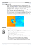
Geosoft Technical Note
Microlevelling Using FFT Decorrugation
Introduction
When working with complex datasets, such as airborne magnetics or radiometrics, a key
data processing objective is to eliminate subtle levelling problems which were not
removed during regular data processing (such as lag corrections, tie line levelling, base
level corrections, etc.).
One definition of “microlevelling” might be “filtering a gridded dataset to reduce or remove
non-geological effects caused by long-wavelength noise along survey lines”. Such noise
manifests itself as apparent data shifts from one survey line to the next, often creating
very streaky looking images. Normally microlevelling is applied only after other
corrections such as diurnal removal and tie-line levelling has already been applied to the
data. See the Geosoft Levelling System Tutorial and User Manual for details on these
types of operations.
There are a number of methods for microlevelling datasets collected along survey lines.
The method described in this Technical Note uses the Oasis montaj™ MAGMAP
module to apply a decorrugation filter in the Fourier domain, then cleans up the levelling
corrections before applying them to the original data in your Oasis database. Note that by
using this procedure you will be unable to distinguish between levelling errors and true
geological information of a similar wavelength which is oriented parallel to the survey
lines. Care should therefore be taken, especially in areas of complex geology.
You can apply the procedure to a gridded dataset alone, as described in Step1 below.
However, for optimum results you will require a database of the data along survey lines,
as well as the grid created from that database (excluding tie lines if present). The data
should already have spikes removed and regular data processing corrections (such as
those listed above) applied.
To use this technique in Oasis montaj, you must be licensed to use the MAGMAP 2D
FFT module as well as the Geophysics Toolkit. You can also purchase through Geosoft a
specialised “Microlevelling for Oasis montaj” package, complete with documentation,
which has been written by the consulting group Paterson Grant & Watson. This
microlevelling system has compressed and automated many of the steps below into a
much simpler process, and uses slightly different filtering techniques.
We use magnetic data in this example. We assume that the corrected starting magnetic
data channel in the Oasis database, which contains remaining levelling problems, is
called “magcor”.
Step 1: Applying a decorrugation filter to yield an “error” grid
As an example, given a magnetic grid surveyed with a nominal line spacing of 150
meters (north-south survey lines), which has a line-to-line levelling problem, we want to
initially produce a grid that contains the levelling error. This is done using a Butterworth
high-pass filter combined with a directional cosine filter.
To perform this step, you will need to know how to use the MAGMAP 2D FFT package.
The parameters are discussed in more detail in the MAGMAP manual or the Online Help
if you need more information.
Following a rule of thumb, the Butterworth high-pass filter is set to four times the line
separation. This is done to pass wavelengths on the order of two to four line separations,
such as would result from a line-to-line levelling error. The directional cosine filter is set to
pass wavelengths only in the direction of the lines. Note that the North-South line
levelling error will produce wavenumbers in the East-West direction (azimuth 90).
Because levelling error is very directional, we are able to tighten the directional cosine
function (to an energy level of 0.5).
The detailed procedure for Step 1 is as follows:
1
If you have not already done so, load the MAGMAP.OMN menu by clicking the Load
menu button (
).
2
On the MAGMAP menu, select Step-by-step filtering|Define filters.
3
Specify a control file name for your filter definitions, for example decor.con. Click the
[OK] button.
4
Select two filters to apply as Butterworth and Directional Cosine. Click [OK].
5
Specify the parameters for the two filters. For the Butterworth filter, choose:
Cutoff Wavelength = 600 (i.e., 4 x line spacing (150) = 600);
Filter Order = 8 (suggested);
High-pass.
6
For the Directional Cosine filter, choose:
Centre Direction = 0; (flight lines' azimuth in degrees, see note above);
Degree of Cosine Function = 0.5 (suggested);
Pass (i.e., pass the features in the specified direction).
7
The filter settings are now saved in the control file you specified (decor.con). You
are now ready to apply the MAGMAP filters. On the MAGMAP menu, click MAGMAP
1-step Filtering (assuming that default settings are adequate for this example).
8
Specify the input total field magnetic grid containing the levelling problems. This is
the grid you want to filter.
9
Specify the output grid as error.grd. This is the grid that is produced by the filter
process.
10 Select decor.con as the filter control file you want to use. Click the [OK] button to
finish.
You may want to view the error grid to ensure your parameters are correct. The grid
should have stripes parallel to the line direction. You can now subtract the error.grd from
the original to remove the levelling error and create a corrected grid.
By comparing the original grid and the corrected grid you can determine if you have
removed an appropriate amount of error. The purpose of microlevelling is to just remove
the levelling error. Using shaded gridding is an effective way of examining gridding errors.
Line levelling errors will show up well in a shaded grid with the sun azimuth set
perpendicular to the line direction.
To get the best results, some tuning of both the center wavenumber of the Butterworth
filter and the energy of the directional cosine may be required. To remove more
directional signal, increase the energy of the cosine filter. To remove wider features,
decrease the Butterworth cutoff point. If you see ringing in the data, decrease the order of
the Butterworth filter.
Step 2: Importing the leveling error and cleaning it.
In this step you will create a Levelling Error channel in your database from the Levelling
Error Grid (error.grd). You will then apply a line-based filter to separate the high
frequency geological signal from the longer wavelength levelling errors.
If you do not actually have located data in a database, you will be unable to complete this
step. However, we recommend that you import the data into your database and apply the
levelling corrections to your original (corrected) data. This procedure has two principal
benefits: you can further improve the levelling corrections, and you will end up with
levelled data in your database, instead of only having a levelled grid.
1
On the Grid menu, click Utilities, and then click Sample a grid…
2
The Sample a Grid dialog box is displayed. This GX uses the X and Y values in the
database to sample the grid and create a new database channel. In the X reference
and Y reference boxes, specify the x and y channels in your database.
3
In the Grid sampled channel box, specify the channel as leverr.
4
In the Grid file box, specify the grid file as error.grd.
5
Next, you must create a Filtered Levelling Error channel called leverr_filt to remove
any remaining geologic signal from the levelling error, along the lines. On the X-Utility
menu, click Filters and then click Low-pass filter…
6
In the Channel to filter box, select the leverr channel.
7
In the Output Channel box, specify the channel as leverr_filt.
8
Specify the cutoff wavelength. The wavelength should be long enough to separate
high-frequency geological information from the long-wavelength levelling error and
the long-wavelength geological signal. For example, a filter length 10 times the line
separation is recommended. Note that the filter wavelength is specified in fiducials,
not metres.
9
Click the [OK] button. You now have a cleaned levelling error channel.
Step 3: Applying the Leveling Correction and Creating a
Leveled grid.
In this final step, you will create a microleveled (maglev) channel by applying a math
formula that subtracts the leverr_filt channel from the magcor channel. The result is a
levelled magnetic data channel in your database.
1
To create a new channel, click the right mouse button on the header cell (the top cell)
of a blank spreadsheet column. On the popup menu, click New.
2
Specify the channel name as maglev. Click the [OK] button. The new channel is
created.
3
On the X-Utility menu, click Expressions, and then click Expression…
4
In the dialog box, type: maglev=magcor – leverr_filt
5
Click the [OK] button. The equation is applied to the maglev channel and the values
displayed in the spreadsheet column.
6
You can now grid the microleveled data channel (maglev) using line gridding. On the
Grid menu, click on Gridding, then click Bi-directional line gridding, and then click
Dialog controls…
7
In the Channel to Grid box, select maglev.
8
Specify a name for the output grid (maglev.grd).
9
If you want, you can specify any of the other parameters in the dialog box to your
preferences or leave the boxes blank to accept the default settings. Click the [Next]
button for more options or the [Finish] button to create the final microleveled grid.
You can use this grid for further processing or interpretation.
For more information on microleveling, contact:
Geosoft Inc.
85 Richmond St. W.
8th Floor
Toronto, Ontario
Canada
M5H 2C9
Paterson Grant & Watson
85 Richmond St. W.
8th Floor
Toronto, Ontario
Canada
M5H 2C9
Tel: (416) 369-0111
Fax: (416) 369-9599
Tel: (416) 368-2888
Fax: (416) 368-2887
Email: [email protected]
web site: www.geosoft.com
Email: [email protected]
web site: www.pgw.on.ca
Microleveling GX information:
http://www.pgw.on.ca/s_gxs.html