1
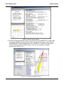
WEATHERPAK® MTR
User’s Manual
February 10, 2006
P/N: 0302140001 Rev. A
COASTAL ENVIRONMENTAL SYSTEMS, INC.
820 First Avenue South • Seattle, WA 98134
(206) 682-6048 (800) 488-8291 Fax: (206) 682-5658
www.CoastalEnvironmental.com
©2006 Coastal Environmental Systems
WEATHERPAK® MTR
USER’S MANUAL
TABLE OF CONTENTS
PAGE
CHAPTER 1
CHAPTER 2
CHAPTER 3
SYSTEM DESCRIPTION.............................................................................. 3
SYSTEM COMPONENTS ............................................................................ 4
INSTALLATION ........................................................................................... 5
3-1
Siting Considerations .....................................................................................................................................5
3-1.1
Compass Issues...........................................................................................................................................5
3-1.2
Wind Measurement Issues ........................................................................................................................5
3-1.3
Radio Transmission Issues.......................................................................................................................5
3-1.4
GPS Operational Issues .............................................................................................................................5
CHAPTER 4
4-1
4-2
4-3
4-4
4-5
CHAPTER 5
5-1
WEATHERPAK® AND PLUME MODELING SOFTWARE ........................ 14
®
ALOHA Data Line Interpretation ..............................................................................................................16
CHAPTER 7
7-1
7-2
7-2.1
7-2.2
7-2.3
7-2.4
7-3
7-4
SYSTEM OPERATION................................................................................. 8
Receiver/Display Functions and Operation ..............................................................................................8
CHAPTER 6
6-1
SYSTEM ASSEMBLY .................................................................................. 6
Receiver/Display Connections .....................................................................................................................6
Connecting to a Computer with Serial Port ..............................................................................................6
Connecting to a Computer with USB Port.................................................................................................6
Connecting to a Computer with the Ethernet Port..................................................................................7
Tripod and WEATHERPAK® Set-up .............................................................................................................7
MAINTENANCE ......................................................................................... 17
Periodic Maintenance Schedule.................................................................................................................17
Troubleshooting.............................................................................................................................................17
The WEATHERPAK®..................................................................................................................................17
The Receiver................................................................................................................................................17
Data Light.....................................................................................................................................................18
The Computer .............................................................................................................................................18
Replacing Tower Batteries and Fuse........................................................................................................18
WEATHERPAK® Low Battery Indication ..................................................................................................18
TABLE OF FIGURES
Figure 1 - Computer with Receiver/Display......................................................................................................... 3
Figure 2 – Back of Receiver/Display Box ............................................................................................................ 7
Figure 3 - Tower Set-up....................................................................................................................................... 7
Figure 4 - Active Screen ...................................................................................................................................... 9
Figure 5 – WEATHERPAK®s Detected Screen................................................................................................. 10
Figure 6 - Preview Screen ................................................................................................................................. 11
Figure 7 - Status Screen.................................................................................................................................... 12
Figure 8 - "No Data" Alert Screen...................................................................................................................... 13
Figure 9 - ALOHA® Screen Capture .................................................................................................................. 15
Figure 10 - ALOHA® with MARPLOT® Map....................................................................................................... 15
Figure 11 - Replacing the Batteries................................................................................................................... 19
Figure 12 - Replacing the Batteries (2) ............................................................................................................. 19
LIST OF TABLES
Table 1 - WEATHERPAK® MTR Components .................................................................................................... 4
1
WEATHERPAK® MTR
USER’S MANUAL
IMPORTANT NOTES
Please call Coastal Environmental Systems if any issues arise or if you have questions about your
WEATHERPAK® MTR.
Coastal Environmental Systems, Inc.
820 First Avenue South
Seattle, WA 98134
Main: 800-488-8291
Fax: 206-682-5658
Parts & Service: x157
[email protected]
•
WHEN CONTACTING US, PLEASE REFER TO THE MODEL AND THE SERIAL
NUMBER of your WEATHERPAK®. The serial number is located on a silver label under the
radiation shield, near the top of the WEATHERPAK®.
•
WASH OR DECON THE WEATHERPAK® WHEN FULLY ASSEMBLED. Do not allow
water to enter the connectors. WEATHERPAK® is water-resistant when assembled.
•
FOLLOW THE MAINTENANCE SCHEDULE. (See the periodic maintenance schedule in
Section 6.1)
•
DO NOT OPEN THE WEATHERPAK®. The WEATHERPAK® is double O-ring sealed and
purged with desiccant to assure a tight seal, and to keep out moisture. Opening the cylinder will
allow moisture in, damage the electronics, and invalidate your warranty.
•
DO NOT PICK UP THE WEATHERPAK® BY THE WIND VANE. This is a durable but
sensitive wind sensor, and it can be broken if it is used to lift the entire unit.
•
DO NOT REMOVE THE ANTENNA FROM THE WEATHERPAK®. If the WEATHERPAK®
is activated without the antenna, the radio will be damaged.
2
WEATHERPAK® MTR
CHAPTER 1
USER’S MANUAL
SYSTEM DESCRIPTION
The WEATHERPAK® MTR measures wind speed and wind direction, air temperature, relative
humidity and barometric pressure. In addition, the WEATHERPAK® calculates the wind stability
class and provides location information. Atmospheric conditions are sampled every second and the
system computes a 5-minute running average. The data is then transmitted every 30 seconds to
the display and plume model.
WEATHERPAK® was specifically designed for use by Hazardous Materials Responders.
following is a list of some of the features that make the WEATHERPAK® MTR unique:
•
•
•
The
WEATHERPAK® MTR features an advanced electronic interface, which allows the use of
features such as GPS and SmartDetect™, the MTR’s unique automatic networking
capability, as well as future enhancements as they are needed.
The wind sensor is an advanced technology, “ultrasonic” style anemometer. The ultrasonic
wind sensor has no moving parts, is very accurate (particularly at very low wind speeds) and
does not require periodic calibration.
WEATHERPAK® MTR features a multi-function, 5.7” full color, flat panel touch screen
display in a ruggedized enclosure. Multiple display screens are available, via the touch
screen, which display data from multiple WEATHERPAK® weather stations.
Figure 1 - Computer with Receiver/Display
In addition to the above, WEATHERPAK® MTR shares the following features with the rest of the
WEATHERPAK® line of products:
•
Automatically updates CAMEO®/ALOHA®, SAFER® Systems, CHARM®, MIDAS® and most
other plume modeling software programs.
3
WEATHERPAK® MTR
•
•
•
•
•
USER’S MANUAL
Built-in electronic compass allows the WEATHERPAK® to be set up in any orientation – will
automatically determine True North and give you true wind direction. 1
Set-up time is less than one minute.
The electrical connections are designed to be intrinsically safe and the housing and tower
are constructed of 6061-T6 aluminum, a non-corrosive and non-sparking alloy.
Designed to withstand decontamination procedures. The WEATHERPAK® housing is
double O-ring sealed and dried with a desiccant to protect the electronics against moisture.
All electronics are grounded at a single point to protect the WEATHERPAK® against EMI
(electro-magnetic interference) and RF (radio frequency) interference, thus assuring reliable
data and transmission.
This manual will familiarize you with the installation, operation, and maintenance of the
WEATHERPAK® MTR. Please read all of the instructions before attempting to operate or
troubleshoot the system.
CHAPTER 2
SYSTEM COMPONENTS
Table 1 provides a description of the components and part numbers the WEATHERPAK® MTR.
Description
WEATHERPAK® sensor package with wind monitor
Upper tower section with j-box and KamLock
Lower tower section
Tower leg – 3 Each
Receiver/Display box
Receiver/Display power supply
Serial to USB converter and driver disk
Serial data output cable
Receiver/Display box antenna
WEATHERPAK® carry-case
Tower carry-bag
User’s Manual
WEATHERPAK® MTR Training Guide (CD)
Part Number
Please Call
1230109038
2531109020
2531109019
1201140002
4050000094
2072000032
6003000046
1914000068
3603000040
S1298
0302140001
1220109001
Table 1 - WEATHERPAK® MTR Components
1 Declination (the variation of True North from Magnetic North) for your location is configured by Coastal Environmental Systems prior to shipping. If necessary, the declination can be
reconfigured. Please contact Coastal’s Customer Service Department if this is necessary.
4
WEATHERPAK® MTR
CHAPTER 3
3-1
USER’S MANUAL
INSTALLATION
SITING CONSIDERATIONS
The following siting considerations need to be addressed:
3-1.1 Compass Issues
The WEATHERPAK® contains an electronic compass for automatic alignment to True North. Like
any compass, an error will be created if it is located too close (laterally) to a large mass of steel or
other magnetic material. (In other words, on top of a van is OK, but next to it is not an ideal
location). Try to place the WEATHERPAK® at least 30 meters from large vans, busses, cranes, etc.
3-1.2 Wind Measurement Issues
Select a site that is as exposed as possible. Structures, trees, terrain, etc. will disrupt the wind flow
for a considerable distance. For example, if the WEATHERPAK® is placed immediately North of
your vehicle and the wind is coming from the South, an erroneous wind direction and speed reading
will result.
3-1.3 Radio Transmission Issues
Locate the WEATHERPAK® as close as safety permits to the hot zone. The WEATHERPAK®s
UHF radio has a range of 5 to 7 miles2 “line-of-sight”. Do not attempt to transmit through structures
containing steel, or through hills.
3-1.4 GPS Operational Issues
There is a GPS receiver inside the MTR Receiver/Display box and a GPS receiver inside the
WEATHERPAK® MTR. These GPS receivers work together and provide data to the SmartDetect™
firmware, which in turn furnishes direction and distance information for additional WEATHERPAK®
MTR’s operating in the vicinity. (The MTR receiver will accept data from WEATHERPAK® TRx’s,
but since only the MTR has a GPS, location information for TRx WEATHERPAK®’s is not available).
The GPS in the Receiver/Display must be connected to an external GPS antenna. The receiver will
automatically begin to search for and track GPS satellite signals at power-up. The antenna must be
outdoors and have a clear view of the sky.
The performance of a GPS receiver at power-up is determined largely by the availability and
accuracy of the satellite ephemeris data and the availability of a GPS system almanac. When the
WEATHERPAK® is powered-up, the GPS searches for satellites from a cold start (no almanac).
While the receiver will begin to compute position solutions within the first two minutes, the receiver
must continuously track satellites for approximately 15 minutes to download a complete almanac.
This initialization process should not be interrupted. Since this initialization process may take up to
15 minutes, the WEATHERPAK® system should be powered up as soon as possible upon arrival at
the incident scene.
2 This distance assumes ideal conditions. Reception range will vary depending on radio signal path.
5
WEATHERPAK® MTR
CHAPTER 4
4-1
USER’S MANUAL
SYSTEM ASSEMBLY
RECEIVER/DISPLAY CONNECTIONS
The WEATHERPAK® MTR Receiver/Display box, as the name implies, contains the radio receiver
and features a 5.7” color TFT display with a touch screen. In addition, it contains a GPS and the
electronics that allow the WEATHERPAK® to communicate with the computer.
The touch screen on the display provides access to multiple screens that display the weather data
in variety of ways, including: “Active” and “Preview” screens, a raw data screen, and a columnar list
of other WEATHERPAK®’s in the vicinity.
1. Connect the external GPS and radio antenna to the appropriate connectors on the back of
display box. (See Fig. 2)
2. Connect the appropriate data cable to either the Serial or Ethernet connector. Please Note:
Connecting via a serial port is the preferred connection method. If your computer doesn’t
have a serial port, use the Serial to USB converter method. The Ethernet connection should
only be used in rare instances where the Receiver/Display box will be connected to a
network.
3. Plug the display box power supply AC cord into a power source (110V, unless otherwise
marked) then plug the mini-plug end into the plug on the back of the display box.
4. Press the green “power on-off” button on the front of the unit. The power indicator light will
illuminate, the Coastal Environmental screen will appear immediately, and the display will
complete its boot-up within 20-30 seconds.
4-2
CONNECTING TO A COMPUTER WITH SERIAL PORT
1. Plug one end of the Serial data cable into the Serial connector on the back of the display
box and the other end into an available 9-pin Serial port on your PC.
2. Turn the receiver on.
3. The receiver power indicator light should now be on.
20-30 seconds to boot-up.
The system will take approximately
4. With the WEATHERPAK® assembled and running and after the display box has completed
the boot-up routine, the amber colored data light will blink approximately every 30 seconds
as an indication that data is being received from the WEATHERPAK®.
4-3
CONNECTING TO A COMPUTER WITH USB PORT
In the event your computer does not have a Serial Port available, or you simply prefer to use a USB
port, you must employ the “Serial to USB” converter. Connect the serial cable to the converter.
Follow the directions provided with the Serial to USB device.
6
WEATHERPAK® MTR
4-4
USER’S MANUAL
CONNECTING TO A COMPUTER WITH THE ETHERNET PORT
This method is to be employed only if the Receiver/Display must be connected to a network.
Please contact Coastal Environmental Systems, Inc. for further information.
Figure 2 – Back of Receiver/Display Box
4-5
TRIPOD AND WEATHERPAK® SET-UP
Assemble the tower in the following manner:
1. Insert and lock the legs onto the bottom section
of the tower, forming the tower tripod base.
2. Align the slot on the WEATHERPAK® with the
guide pin on the quick release and push straight
in. DO NOT “screw” the WEATHERPAK® onto
the KamLock connector. The KamLock provides
a precision sealed fit and may require an extra
push to properly seat the WEATHERPAK®. Once
the weather station is properly seated, press the
arms of the clamp down to assure a tight fit.
3. Place the entire unit (upper tower section and
WEATHERPAK®) onto the tripod and fingertighten the tower locking screw.
4. The WEATHERPAK® is now running and
sampling data. When the WEATHERPAK® is
removed from the KamLock connector, it will
stop sampling and shut itself off.
Figure 3 - Tower Set-up
7
WEATHERPAK® MTR
CHAPTER 5
USER’S MANUAL
SYSTEM OPERATION
Once set up, the WEATHERPAK® automatically begins sampling weather conditions and transmits
data to the Receiver/Display every 30 seconds. (See “Data Line Interpretation”, Page 12, for more
detailed information).
The Receiver/Display takes approximately 30-45 seconds to complete a boot-up routine. When this
process is complete the Receiver/Display is ready to accept the first transmission from the
WEATHERPAK®. You can now view the data on the Receiver/Display box, run plume modeling
software, or view and archive the data using Coastal’s optional INTERCEPT™ Software.
During the boot-up process a touch screen button will appear that is labeled “Calibrate Screen”.
This button re-aligns the touch screen. There is no need to calibrate the display screen every time
the system is turned on. If, over time, the screen has become misaligned or the touch screen
buttons are not functioning properly, re-start the Receiver/Display and touch the “Calibrate Screen”
button during the boot-up process.
5-1
RECEIVER/DISPLAY FUNCTIONS AND OPERATION
The touch screen on the display provides access to multiple information screens that display the
weather data in variety of ways. The screens include the “Active” and “Preview” screens, a raw
data screen, and a columnar list of other WEATHERPAK®’s in the vicinity. The following is a
summary of the function of each screen:
•
The Active Screen is the most important and most frequently used information screen. It
displays the data received from the “Active” WEATHERPAK®. An Active WEATHERPAK®
is defined as the weather station which has been selected to provide data to the plume
model. Access to all other screens is initiated here.
• The WEATHERPAK®’s Detected Screen displays data from other WEATHERPAK®’s
detected in the vicinity, in a columnar fashion. If any of the remote systems are
WEATHERPAK® MTR’s, the relative position (direction and distance) will also be displayed
for those stations.
The Preview Screen displays data from any one of the stations listed on the
“WEATHERPAK®’s Detected” Screen and allows the operator to view the status of that
system and change its Active or Default status, if desired. Please Note: Reset the default
upon receiving your new WEATHERPAK® MTR. It is common practice for organizations
to purchase multiple WEATHERPAK® weather stations and then distribute the systems to
several teams without taking into account the factory default setting. (See Ch. 5, Sec. 5-1,
Part 3.2 - Changing or Setting the Default WEATHERPAK®).
•
WEATHERPAK® Status Screen displays the unique serial number of the WEATHERPAK®,
its tower battery voltage, and the raw data line being transmitted by the selected
WEATHERPAK®.
8
WEATHERPAK® MTR
USER’S MANUAL
1. ACTIVE SCREEN - Once the boot-up process, which may take 30-45 seconds, is complete,
the “Active” screen appears and data from the “Default” WEATHERPAK® is automatically
displayed, as soon as the first transmission from the weather station is received (See Fig.
4).
The screen label “Active” is in the upper left corner of the screen followed by the unique
serial number of the currently Active WEATHERPAK®. The data validity indicator is located
in the upper right corner of the screen. Green indicates the data is current and valid. Red
indicates no data has been received from the WEATHERPAK® for more than two minutes.
The data fields presented on this screen are:
-
5-minute running average of wind speed and wind direction (in degrees 0-360).
5-minute average air temperature.
Relative humidity
Barometric pressure
Latitude and Longitude
(Ch. 5, Sec. 5-1, Part 4 WEATHERPAK® Status Screen provides a detailed description of
data output).
There are two touch screen buttons located near the bottom of the screen. One is
WEATHERPAK®’s Detected, followed by the number of systems located, and the other is
labeled WEATHERPAK® Status. Touch the WEATHERPAK®’s Detected button to view a
columnar listing and data from the additional WEATHERPAK®’s in the vicinity. Touching the
WEATHERPAK® Status button will open the WEATHERPAK® Status screen for the Active
WEATHERPAK®.
Figure 4 - Active Screen
9
WEATHERPAK® MTR
USER’S MANUAL
2. WEATHERPAK®’s DETECTED SCREEN – This screen is accessed by touching the
“WEATHERPAK®’s Detected” button on the Active Screen and it lists, in a columnar
fashion, all WEATHERPAK®’s detected by the receiver (See Fig. 5).
The data displayed is as follows:
• WPAK lists the unique serial numbers in the order they were detected.
• WSPD is the “instant” wind speed. Instant wind speed is the wind speed measured one
second before the data transmission. (This number will almost always be different than
the 5-minute averaged wind speed displayed on the Active Screen).
• WDIR is the same as above except the measurement is wind direction.
• LOC is the direction to the remote weather station.
• DIST is the distance (in statute miles) to the remote weather station.
• Status Touching this button will open the Status Screen for the selected
WEATHERPAK®.
2.1 Color Indicators
Some information on this screen is color-coded to provide additional information:
Green text identifies the Active WEATHERPAK® and indicates valid data.
Yellow text identifies systems other than the Active system and indicates valid data.
Red text indicates the data has not been updated for more than two minutes and may be
invalid.
The data indicator in the upper right corner of the screen indicates the Active
WEATHERPAK®’s data status. Green is valid. Red indicates no data received for more
than two minutes.
2.2 Previewing Non-Active WEATHERPAK®’s Touch the appropriate data line and the
Preview Screen will open, displaying the information for the selected WEATHERPAK®.
2.3 Other Controls on the WEATHERPAK®’s Detected Screen
Touch “Status” to view the Status Screen of the selected WEATHERPAK®
Touch “Exit” to return to the Active Screen
Figure 5 – WEATHERPAK®s Detected Screen
10
WEATHERPAK® MTR
USER’S MANUAL
3. PREVIEW SCREEN - The layout is similar to the Active Screen, but the Preview Screen serves
a very different function. When viewing data on the Preview Screen you are simply
“previewing” one of the non-active weather stations. The currently Active WEATHERPAK® is
still sending data to the plume model. ALOHA® (and similar plume modeling programs) are
only able to accept data from one weather station at a time. The WEATHERPAK® 400 MTR is
unique in that it allows the operator to select which weather station sends data to the model.
When the Receiver/Display is turned on it “looks” for the default WEATHERPAK®. The default
system is then listed first on the “WEATHERPAK®’s Detected” page and is automatically
designated as the Active WEATHERPAK®.
Previewing allows the operator to view detailed weather data from other WEATHERPAK®
locations. If it is determined the Previewed WEATHERPAK® is providing more representative
information, the operator may select the alternate WEATHERPAK® as the Active system and
send that data to the plume model.
3.1 Changing the Active WEATHERPAK® - To reassign the previewed station to Active
status, simply touch “Select as Active” button near the bottom of the Preview Screen.
3.2 Changing or Setting the Default WEATHERPAK® - We recommend you reset the
default upon receiving your new WEATHERPAK® MTR. It is common practice for
organizations to purchase multiple WEATHERPAK® weather stations and then distribute the
systems to several teams without taking into account the factory default setting.
When you receive your new WEATHERPAK® MTR the default is factory set according to the
following convention:
• If one weather station is purchased with one MTR Receiver/Display unit, the
WEATHERPAK® that comes with the system is the default.
• If multiple WEATHERPAK®’s are purchased with the one MTR Receiver/Display, the
weather station with the lowest serial number is selected as the default.
The Default WEATHERPAK® may be set or changed by the following procedure. Open the
“WEATHERPAK®’s Detected” screen and select the system you wish to designate as the
default by touching the corresponding line on the display. The Preview Screen will appear;
touch the “Make Default” button. The new default WEATHERPAK® is now set. Once set, the
default serial number is maintained in the Receiver/Display’s microprocessor and need not be
reset during subsequent uses. The operator may, however, change the default at any time by
repeating this procedure. (See Fig. 6)
Figure 6 - Preview Screen
11
WEATHERPAK® MTR
USER’S MANUAL
4. WEATHERPAK® STATUS SCREEN – This screen displays all the information being
transmitted by the selected WEATHERPAK®. (See Fig.7)
•
•
•
WPAK: is followed by the unique serial number. Every WEATHERPAK® has a unique
ID number.
Battery Voltage: is the tripod battery voltage. When fresh batteries are installed the
reading will be 13.5 VDC. This number will go down slowly as the batteries are
depleted. Batteries should be replaced when this reading reaches 10.7 or lower.
Data Message: is the raw data message being transmitted by the WEATHERPAK® and
will look similar to the following:
1329,2.19,140,67.7,23.2,2.9,187,73.7,11.9,2018,1008,27,2661,4,1439,4735.7
05,-12220.026,,,,2893
DATA LINE INTERPRETATION
ID, MW, MD, ST, AT, SI, DI, TI, BV, CKSUM1, BP, RH, CKSUM2, SAT, GMT, LAT,
LON,,,,CKSUM3
ID –
MW –
MD –
ST –
AT –
SI –
DI –
TI –
BV –
CKSUM1 –
BP –
RH –
CKSUM2 –
SAT –
GMT –
LAT –
LON –
CKSUM3 –
WEATHERPAK® unique identification number
5 minute averaged wind speed in meters per second
5 minute averaged wind direction in degrees
Stability class in degrees
5 minute averaged air temperature in degrees Celsius
Instantaneous wind speed in meters per second
Instantaneous wind direction in degrees
Instantaneous air temperature in degrees Celsius
Battery voltage in volts
First checksum
Barometric pressure in millibars
Relative humidity in percent
Second checksum
Number of satellites acquired
Greenwich Mean Time
GPS Latitude
GPS Longitude
Third checksum
Figure 7 - Status Screen
12
WEATHERPAK® MTR
USER’S MANUAL
5. “NO DATA” ALERT SCREEN
If no data is received for more than two minutes from the viewed WEATHERPAK® (Active or
Previewed), the “No Data” alert shown in Figure 8 will come up. This message is intended to
alert the operator that there may be a problem with the system. This message simply indicates
there has been an interruption in the flow of data from the met station to the receiver which has
lasted longer than two minutes and should be investigated. There are a variety of reasons this
may occur. Here are a few:
•
•
•
•
The WEATHERPAK® tripod tower batteries may need replacing.
The station may be out of range due to repositioning of the weather station.
Line-of-sight may have been lost due to repositioning of the station or your vehicle, or a
vehicle may have moved into the line-of-sight.
System malfunction is also a possibility, but it is among the least likely.
Figure 8 - "No Data" Alert Screen
13
WEATHERPAK® MTR
CHAPTER 6
USER’S MANUAL
WEATHERPAK® AND PLUME MODELING SOFTWARE
When the WEATHERPAK® is set up and operational, and the Receiver/Display box connected to
your computer, real-time data is available to run air dispersion plume modeling software.
IMPORTANT NOTE: Some earlier versions of ALOHA® (including 5.2.1) need to be upgraded in
order to work with a Station for Atmospheric Measurement (SAM); the WEATHERPAK® is a SAM.
The U.S. EPA provides CAMEO®/ALOHA® software downloads, support, and information at its
website: http://www.epa.gov/ceppo/cameo.
The following is a brief outline of the steps taken to produce an ALOHA® plume model on a PC
operating Windows®. Our assumptions are that the user is familiar with ALOHA® and that the
program is properly loaded onto the user’s computer. Coastal Environmental recommends
consulting the ALOHA® web site and/or a certified CAMEO®/ALOHA® instructor for training,
program details and limitations.
1. Open ALOHA® by clicking on its desktop icon, or selecting it from the Windows® Programs
menu. An “Air Model Limitations” dialogue box will appear with important notes on program
limitations. Read them, and select “OK”.
2. A “Text Summary” window will appear with information summarizing the event.
3. Confirm that your “Site Data” information is correct. If required, use the [SiteData] dropdown menu to change data.
4. Select the drop-down menu [SetUp] - [Chemical]. Choose the appropriate chemical.
5. Select the drop-down menu [SetUp] – [Atmospheric] – [SAM Station]. A series of dialogue
boxes will then appear requiring user observations or assumptions. Please note: relative
humidity is not automatically captured by the ALOHA® model and may be manually entered
using data from the WEATHERPAK® display.
6. (Optional) To confirm that the WEATHERPAK® data is being delivered to ALOHA®, use the
drop-down menu [SAM Options] - [Processed Data]. A “Processed SAM Data” window will
appear. Please Note: If the WEATHERPAK® has been collecting data for less than five
minutes a warning message will be displayed in both the Text Summary and Processed
SAM Data windows.
7. ALOHA® requires that the SAM station be operating for five minutes before allowing the
selection of the source of the release (tank, pipe, direct, etc.). Select the drop-down menu
[SetUp] – [Source]. Select the source of the leak (tank, for example); a series of dialogue
boxes will then appear requiring user observations or assumptions.
8. Select the [Display] – [Footprint] drop-down menu. A “Level of Concern” dialog box will
appear with default ERPG ranges displayed. Select “OK” to show the plume footprint.
Displaying the footprint in ALOHA® is essential before the plume can be overlaid on a
MARPLOT® or other street map.
9. (Optional) Select the [Display] drop-down menu to produce graphs for source strength and
concentration.
14
WEATHERPAK® MTR
USER’S MANUAL
Figure 9 - ALOHA® Screen Capture
10. Select the [Sharing] drop-down menu to plot the plume onto a MARPLOT® (or other) map.
As weather conditions change, the plume size and position will change, shortly after the
WEATHERPAK® provides updated data. Note: MARPLOT® software requires that the
ALOHA® window overlay the map window in order for the map-plume to update
automatically. (See Fig. 10)
Figure 10 - ALOHA® with MARPLOT® Map
15
WEATHERPAK® MTR
USER’S MANUAL
The WEATHERPAK® reads the sensors every second and automatically applies an algorithm to the
sensor data to calculate five-minute running averages. This calculated data is transmitted, along
with the “INSTANTANEOUS” data, every thirty seconds to the receiver and subsequently the plume
model. In addition, the WEATHERPAK® calculates Sigma Theta. This is a measurement of air
turbulence, which affects the mixing or dispersion of a chemical in the atmosphere. Sigma Theta is
also referred to as “Stability.”
The “INSTANTANEOUS” data is the last direct sensor reading prior to the thirty-second update.
The operator may be able to detect a trend (i.e. wind shift) by comparing the “5 MINUTE RUNNING
AVERAGE” and “INSTANTANEOUS” data. The battery voltage is also transmitted. Please Note:
If the battery voltage falls below 10.7 VDC, the batteries in the WEATHERPAK® tower should be
replaced.
If you drop-down the [SAM Options] from the Main menu and select [Raw Data], something like
the following line of data will appear:
421, 0.9, 225, 1.0, 23.9, 1.0, 226, 23.9, 14.0, 1917, 999, 46, 2536
This is ASCll data being sent by the WEATHERPAK®. Notice that most of these numbers will
appear in the “Processed Sam Data” dialog screen in ALOHA®. The difference is that there are no
labels and some additional number characters are present. In addition, this raw data is delivered in
metric units (millibars, m/s, C), whereas the processed data has been converted to Standard
English units (inches, MPH, F).
Two “checksums” are performed to ensure that the message was sent correctly. The computer
adds up the “ASCII value” of the data line (each letter, number, comma, etc., has a numerical value
universal to all computers) to make sure that the computer received the same number that the
WEATHERPAK® transmitted.
6-1
ALOHA® DATA LINE INTERPRETATION
The data line fields are as follows:
ID, MW, MD, ST, AT, SI, DI, TI, BV, CKSUM1, BP, RH CKSUM2
ID –
MW –
MD –
ST –
AT –
SI –
DI –
TI –
BV –
CKSUM1 –
BP –
RH –
CKSUM2 –
WEATHERPAK® unique identification number
5 minute averaged wind speed in meters per second
5 minute averaged wind direction in degrees
Stability class in degrees
5 minute averaged air temperature in degrees Celsius
Instantaneous wind speed in meters per second
Instantaneous wind direction in degrees
Instantaneous air temperature in degrees Celsius
Battery voltage in volts
First checksum
Barometric pressure in millibars
Relative humidity in percent
Second checksum
16
WEATHERPAK® MTR
CHAPTER 7
7-1
USER’S MANUAL
MAINTENANCE
PERIODIC MAINTENANCE SCHEDULE
Routine maintenance is required on the WEATHERPAK® every 12 months. This maintenance is to
ensure that the overall system and its sensors are working and performing within specification. The
actual services vary, based on the sensors installed on your WEATHERPAK® model. For example,
a WEATHERPAK® MTR should have the compass, air temperature, relative humidity, and the
barometric pressure sensors tested to their stated specifications. (The wind monitor does not
require periodic calibration or maintenance). In addition, the entire WEATHERPAK® should be
examined for any wear, damage or other non-conforming variances. Please contact Coastal
Environmental System’s service department (800-488-8291 x157) for more information or to make
arrangements for maintenance on your WEATHERPAK®.
7-2
TROUBLESHOOTING
Do not take the WEATHERPAK® or the receiver box apart; this will void the warranty. If the
procedures below do not solve the problem, call Coastal Environmental Systems’ Service
Department (800-488-8291 x157).
7-2.1 The WEATHERPAK®
When the WEATHERPAK® system is assembled, it automatically powers up, finds True North and
begins sampling the atmospheric conditions; it then transmits weather data every 30 seconds. If it
does not, check the following, in this order:
• Confirm that the WEATHERPAK® is properly secured in the KamLock connector on the
tripod tower.
• Check the batteries in the tower. Use only high quality alkaline batteries. (Do not use
rechargeable batteries).
• Check the fuse. The fuse is in an in-line fuse holder located in the junction box at the top of
the tripod tower. Access the fuse by removing the two screws on the junction box cover.
Use only a 3AGC replacement fuse.
7-2.2 The Receiver
Is the Receiver box on?
The power indicator light should be on and the display characters visible. If this is not the case,
check the following:
•
•
Be sure the receiver unit is plugged in and turned on.
Check the power at the outlet.
17
WEATHERPAK® MTR
USER’S MANUAL
7-2.3 Data Light
Data light not flashing?
Every 30 seconds (approximately), the amber colored data light will flash, signifying that the
WEATHERPAK® is sending data to the Receiver/Display. If the light does not flash, then do the
following:
•
•
•
•
•
•
Be sure the receiver unit is plugged in and turned on. Check the power indicator light on the
“on/off” switch on the front panel.
Check to see if the WEATHERPAK® is “line-of-sight” (less than 5-7 miles, and not blocked
by an obstruction (hills, vehicles, steel buildings, etc.).
Check to see that both the WEATHERPAK® antenna and the receiver antenna are securely
connected.
Reset the system by removing the WEATHERPAK® from the KamLock connector on the
tower… Wait 10 seconds, and then replace the WEATHERPAK® on the tower.
Check to see if the “low battery” beeper in the tower is beeping. Replace batteries if
necessary.
Check that the batteries in the tower are properly aligned (positive towards the top of the
tower).
7-2.4 The Computer
There is data on the display but no data on the computer.
• Check all the connections from the receiver to the computer.
Error messages while running plume model.
These are not related to the use of the WEATHERPAK®; these are coming from the plume
modeling software.
• Consult the CAMEO®/ALOHA® website… www.epa.gov/ceppo/cameo.
• Contact Coastal Environmental Systems as a last resort. We are not certified
CAMEO®/ALOHA® representatives; however, we may be able to help.
7-3
REPLACING TOWER BATTERIES AND FUSE
The WEATHERPAK® has nine alkaline “D” cell batteries, which are located in the upper section of
the tower, as shown in Figures 11 & 12 below. The batteries must be replaced with high quality
alkaline batteries. Rechargeable batteries typically do not perform well in the WEATHERPAK®.
(See Fig. 12)
There is an in-line fuse located in the tower junction box. (See Fig. 11)
7-4
WEATHERPAK® LOW BATTERY INDICATION
The battery voltage reads below 11.0 on the “Processed Sam Data” screen (Page 15) or the
MTR “Status” Screen (Page 12).
18
WEATHERPAK® MTR
USER’S MANUAL
Figure 11 - Replacing the Batteries
Figure 12 - Replacing the Batteries (2)
You will need a large screwdriver to replace the batteries. The battery “plug” is slotted. With the
screwdriver, PUSH (the plug is held in place by a spring)…then rotate the plug clockwise. The plug
will come out, followed by a spring, and then the batteries. Slide the new batteries in (positive end
first) and replace the spring and plug.
To check the new voltage, set up the WEATHERPAK® and then open the ALOHA® plume model.
Drop down the [MISC] menu to “Processed Sam Data”. One of the items shown is battery voltage.
With new batteries installed, it should read about 13 to 15 volts. The towers ‘low-voltage” beeper
will go off when the battery voltage reaches 11.0 volts.
19