1
ArcGIS 9
®
Geocoding Rule Base Developer Guide
Copyright © 2003 ESRI
All rights reserved.
Printed in the United States of America.
The information contained in this document is the exclusive property of ESRI. This work is protected under United States copyright law and other
international copyright treaties and conventions. No part of this work may be reproduced or transmitted in any form or by any means, electronic or
mechanical, including photocopying and recording, or by any information storage or retrieval system, except as expressly permitted in writing by ESRI.
All requests should be sent to Attention: Contracts Manager, ESRI, 380 New York Street, Redlands, CA 92373-8100, USA.
The information contained in this document is subject to change without notice.
CONTRIBUTING WRITERS
Agatha Tang and Kristin Clark
U.S. GOVERNMENT RESTRICTED/LIMITED RIGHTS
Any software, documentation, and/or data delivered hereunder is subject to the terms of the License Agreement. In no event shall the U.S. Government
acquire greater than RESTRICTED/LIMITED RIGHTS. At a minimum, use, duplication, or disclosure by the U.S. Government is subject to restrictions
as set forth in FAR §52.227-14 Alternates I, II, and III (JUN 1987); FAR §52.227-19 (JUN 1987) and/or FAR §12.211/12.212 (Commercial Technical
Data/Computer Software); and DFARS §252.227-7015 (NOV 1995) (Technical Data) and/or DFARS §227.7202 (Computer Software), as applicable.
Contractor/Manufacturer is Environmental Systems Research Institute, Inc., 380 New York Street, Redlands, CA 92373-8100, USA.
ESRI, ArcIMS, MapObjects, ArcView, Avenue, StreetMap, ArcCatalog, ArcMap, ArcSDE, ArcLogistics, SDE, Spatial Database Engine, and ArcToolbox
are trademarks, registered trademarks, or service marks of ESRI, registered in the United States, the European Community, or certain other jurisdictions.
The names of other companies and products herein are trademarks or registered trademarks of their respective trademark owners.
Contents
1 Introduction
1
What is geocoding? 2
Components in the geocoding process
General process of geocoding 4
How to use this book 8
2 Overview of the rule base
The standardization process
MatchRules 12
3 The match file
3
9
10
13
Overview of the match file 14
VAR commands 15
MATCH commands 16
VARTYPE commands 18
m and u probabilities 19
Matching weights 20
Modifying the .mat file 21
4 The command file
23
Overview of the command file 24
Parsing parameters 25
Adjusting parsing parameters 26
Adding the DEBUG and OUTFILE keywords to the us_addr.stn file 27
5 The match key dictionary
29
Overview of the match key dictionary 30
Modifying the match key dictionary 32
iii
6 The classification table
12
35
Overview of the classification table 36
How to get to the classification table 37
How the classification table is formatted 38
Modifying the .cls file 40
7 The pattern file
45
Overview of the pattern file 46
Pattern rules 48
Actions 55
Modifying the pattern file 60
Dealing with street intersections 64
Editing intersection .xat/.pat files 66
Adding custom routines to the pattern file
8 Developer’s Kit tools
67
69
STANEDIT and the DEBUG and OUTFILE keywords 70
Creating a new process with STANEDIT 72
ENCODPAT 73
What to do before adding your files to the folder 74
Appendix A: Data dictionaries and match rules syntax
Introduction 76
Data dictionaries and match specifications
Geocoding 87
Record linkage concepts 88
iv
75
77
GEOCODING RULE BASE DEVELOPER GUIDE
Appendix B: Standardization process syntax
93
Introduction 94
Input file format specifications 96
The match key 103
The classification table 107
The pattern rules 110
Unconditional patterns 114
Conditional patterns 121
Actions 129
Summary 142
Appendix C: Developer’s Kit software tools reference
143
Developers Kit software tools reference 144
Appendix D: Matching and standardization file conventions and
limits 149
Conventions and limits
Glossary
Index
CONTENTS
150
151
163
v
Introduction
IN THIS CHAPTER
• What is geocoding?
• Components in the geocoding
process
• General process of geocoding
• How to use this book
1
If you are reading this book, chances are you have learned quite a bit about
using ESRI® geocoding products, such as ArcGIS®, ArcIMS®, MapObjects®,
ArcView® 3.x, and so on, and are now ready to do some customization of
the rule base to make the applications even more useful to you.
This book will walk you through concepts about the Geocoding Developers
Kit and tasks that will show you how to take full advantage of the kit. Each
chapter, with the exception of Chapter 2, which provides an overview of the
rule base, focuses on a specific aspect of the kit. For example, Chapter 3
looks at the match file, Chapters 47 focus on the files that make up the
standardization process, and Chapter 8 examines the tools that come with
the Geocoding Developers Kit.
You can use this book as a reference for a specific problem or read through
it to gain a complete understanding of the process of customizing the rule
base. Either way, this book will be useful in helping you get the most out of
your geocoding applications.
1
What is geocoding?
Geocoding, which is also known as address matching, is the
process of assigning an x,y coordinate value to the description of
a place by comparing the descriptive location elements to those
present in the reference data. These x,y coordinates are points
that can be displayed on a map.
Geocoding is useful because, in many cases, geographic data
exists that describes locations such as street addresses, city
names, ZIP Codes, or even telephone numbers. While humans
understand what these descriptions mean and how they relate to
locations on the earths surface, computers do not. To display
these locations on a map and perform analyses with them, a
computer must be given geometric representations, such as point
features, of these locations.
How the Geocoding Rule Base Developer Guide
can help you
You can use the Geocoding Rule Base Developer Guide to learn
how to modify the address standardization process and match
rules. Address standardization is implemented using a pattern
recognition method associated with lookup tables. Some tasks,
such as adding a new street type value or modifying the
abbreviation of a standardized street type, can be done by simply
editing a text file. If you need to add or alter the standardization
process of certain unusual addresses, you can learn and use the
pattern recognition syntax described in Chapter 7, The pattern
file, and start writing or modifying the patterns in the existing
rule base file.
2
GEOCODING RULE BASE DEVELOPER GUIDE
Components in the geocoding process
The geocoding process requires reference data, address data, and
software. This section will discuss each of these components.
Reference data
Reference data is referred to as geographic base files (GBFs). It
can vary from simple digitized boundary files to more complex
address coding guides (ACGs) to even more sophisticated street
centerline files.
Reference data is available from both public and private data
publishers. The public data publishers include the U.S. Census
Bureau TIGER and United States Postal Service (USPS) city/state,
five-digit ZIP Codes, and ZIP+4 files. The private data publishers
include Geographic Data Technology, Thomas Bros.,
NavTech, and Tele Atlas. In addition to the public and private
data publishers, there are also some specialized GBFs. They
include floodplains, telephone switch centers, and third-party
address coding guides.
Address data
Address data types vary by application. Some examples are
customer addresses, location of the event or incident (such as
accidents, fires, crimes, and so on), location of equipment and
facilities (such as pay phones, electrical transformers,
convenience stores, and so on), and monument offset (for
example, two miles from the intersection of State Route 57 and
Main Street).
Software
Some systems have been designed and implemented for a specific
geocoding discipline. Typically, these systems are integrated with
a single GBF. These systems are hard-coded and difficult to finetune.
Probabilistic record linkage systems use a statistically valid form
of fuzzy logic to score how well records do or do not match. This
type of system allows for reviews of almost matches: finetuning of the matching rules, table, and cut-off thresholds.
Geocoding software needs to operate in both sequential batch
mode and single event mode. It also needs to be able to integrate
with other applications and operate transparently (because
geocoding may be part of an interactive client/server
environment) and be able to integrate easily with spatial analysis
software.
ESRIs geocoding applications are built on top of MatchWare
Technologys Probabilistic Record Linkage system. The
applications incorporate fuzzy matching logic, are flexible and
customizable, operate in both batch and single event modes,
integrate well with other applications, and are integrated with a
geographic information system (GIS).
Typically, input records are captured without regard to standards
or format. In addition, in most instances, records contain errors
and omissions. These errors, however, may be corrected through
a standardization process or address lookup from a reference
database.
INTRODUCTION
3
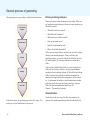
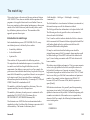
General process of geocoding
The general process of geocoding is outlined in the chart below:
Define matching
strategies
Standardization
Blocking
Matching
Review/Edit
Defining matching strategies
Matching strategies define the method of geocoding. When you
are looking at matching strategies, there are certain questions you
should ask yourself:
What fields need to be indexed?
What fields will be matched?
What would you consider a match?
How do you handle errors?
How will you do manual review?
What is the default functionality?
After you have answered these questions, you are ready to begin
defining your matching strategies. When you define your
matching strategies, you need to identify the fields that the style
will match against. The reference data needs to contain these
fields.
After you have identified these fields, you need to identify the
fields used for blocking, which is a way to group information
together for faster searching. Indexes will be built for the blocking
fields. You also need to identify the address components for
matching. Each applicable address component is called a match
key. At a minimum, the match key should contain house number,
prefix type, prefix direction, street name, street type, and zone
fields. For more information about match keys, see
Chapter 5, The match key dictionary.
Standardization
As the chart shows, the geocoding process has five stages. This
section gives a brief introduction to the process.
4
Standardization has two steps. The first step, preparing the
reference file, includes separating the data into individual fields
GEOCODING RULE BASE DEVELOPER GUIDE
and using standardized names or abbreviations. To secure a good
match rate, all names or abbreviations should be considered
across the database.
Without blocking, every record is reviewed:
The second step, preparing the addresses for matching, includes
breaking down the address data into individual fields and
converting the values, if needed, with standard abbreviations
such as AVE for AVENUE.
The following are some standardization examples:
380 New York St
380 = House number
New York = Street name
St = Street type
With blocking, only blocked records are reviewed:
123 1 St St St 123
123 = House number
1 St = Street name
St = Street type
St 123 = Suite number
Blocking
Blocking, a way to group relevant information together, reduces
the number of potential matches that need to be checked. It
requires fast index lookup and an efficient index search method,
such as Soundex.
Soundex
One common method of indexing names is to use Soundex.
Soundex finds the match plus all the potential candidates. For
example, you may want to search for Main Street. Soundex will
find Main, as well as Memne. Soundex is particularly useful when
you are working with names that are easily misspelled. Soundex
encoding transforms a string into code that tends to bring
INTRODUCTION
5
together all variants of the same string. In the example of Main
and Memne above, both words would be coded M500.
For address matching, street name is often an important blocking
variable. To maximize the chance that similarly spelled street
names reside in the same index block, the Soundex system can be
used to code the street names, and the Soundex code can be used
as a blocking variable.
There are six steps to encoding a string using the Soundex
method.
1. Retain the first letter of the string, and drop all occurrences of
a, e, h, i, o, u, w, and y in other positions.
2. Assign the following numbers to the remaining letters after
the first:
b, f, p, v: 1
c, g, j, k, q, s, x, z: 2
d, t: 3
l: 4
m, n: 5
r: 6
3. Ignore the spaces if the string contains multiple words.
4. If two or more letters with the same code were adjacent in the
original string (before step 1), omit all but the first.
5. Convert to the form letter, digit, digit, digit by adding trailing
zeros if there are less than three digits or by dropping the
rightmost digits if there are more than three.
6. For any character that cant be mapped, ESRIs geocoding
products either retain the character or skip to the next
character for generating the Soundex code.
6
Matching
The software uses field-by-field comparisons to generate a
detailed candidate score and to determine a good match. In fieldby-field comparisons, the software compares each field of the
candidate address to each field in the original address. For
example, it compares the prefix direction in the address being
searched to the prefix direction in the reference data.
There are several types of comparisons, including uncertainty
character comparison and left/right interval comparisons.
Uncertainty character comparison is usually used to compare
street names and zones in order to allow more flexibility in
matching even if the names are misspelled, which is likely to
happen in street names and zones.
Left/Right interval comparisons compare the house number
against number ranges in a format of two intervals: one for the
low and high numbers on the left side of the street, and one for
the low and high numbers on the right side of the street.
With all these types of comparisons, the closer the candidate
fields are to the standardized address fields, the higher the
candidate score. The candidate score is calculated based on the
matching and unmatching probabilities, also called the m and u
probabilities. For more information about the m and u
probabilities, see Chapter 3, The match file.
A composite score is computed by summing the score
contributed by each element. The score is normalized to a value
between 0 and 100. The software ranks the candidates by the
score and thus determines which candidate is a good match.
For more information on matching, see Chapter 3, The match file.
GEOCODING RULE BASE DEVELOPER GUIDE
Review/Edit
You can fine-tune the geocoding process during the review/edit
stage. In other words, you can adjust index search rules, adjust
matching weights, and adjust minimum matching scores. By
manipulating each of these parameters, you can get results that
are the most useful to you. Once you have everything set up as
you like, you will be able to find the candidates you want.
INTRODUCTION
7
How to use this book
This book is intended for the geocoding user who wants to
modify and customize the geocoding rule base. It is primarily
intended to give conceptual and hands-on information about the
Geocoding Developers Kit. If you would like to review some of
the basics of geocoding in ArcGIS, see Geocoding in ArcGIS.
As most of the ESRI GIS products, including ArcGIS, ArcSDE®,
ArcIMS, MapObjects, ArcLogistics Route, and ArcView, use
the same geocoding engine, modifying the rule base can be done
once and applied to all these products. This book is not designed
to go into depth about ArcGIS or MapObjects software; instead,
it is a more generic and conceptual book about the Geocoding
Developers Kit. For more information about geocoding in
specific applications, review the introductory documentation
applicable to your specific application.
The overall goal of this book is to give you an understanding of
how to use the Geocoding Developers Kit and modify the rule
base. It will introduce you to the tools included in the kit and
show you specific tasks in modifying your geocoding rule base
files to make them more useful to you. The concepts presented
here and the tasks that accompany them are intended to give you
a better understanding of how to manipulate the rule baseafter
you familiarize yourself with the concepts and tasks, you should
be able to use the Geocoding Developers Kit to perform
advanced customization of your rule base.
8
GEOCODING RULE BASE DEVELOPER GUIDE
Overview of the rule base
IN THIS CHAPTER
• The standardization process
• MatchRules
2
The rule base is a collection of files that direct the geocoding engine in how
to standardize address data and match that data to the related location in the
reference data. This chapter provides an overview of the rule base and what
it comprises. The first section focuses on the standardization process, and
the second section looks at the match rules. Later chapters go into great
detail about the topics that are introduced here.
9
The standardization process
Standardization is a process of address parsing that prepares
the address to be matched against the reference data. It breaks
down the address into elements, assigns them to the match keys,
and converts the abbreviated address elements into standardized
values (for example, AVE for Avenue). Instead of looking in the
reference data for one single string (the address), the
standardization is essential for preparing the address data that
allows the geocoding engine to search for possible candidates
and matching the address more efficiently by using street name
search and field-to-field comparison.
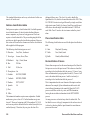
A standardization process contains standardization commands
(<file>.stn), a match key dictionary for the event address
(<file>.dct), a classification table for providing standard address
abbreviations (<file>.cls), and patterns and actions for
standardizing an address (<file>.pat). The standardization
process can also contain additional tables, such as <file>.tbl, but
they are optional. By making modifications in each of these files,
you can alter the way the geocoding process is done.
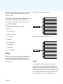
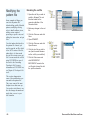
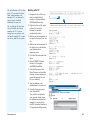
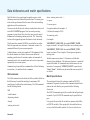
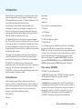
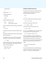
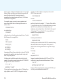
Relationship between MatchRules and StanRules (standardization process)
Reference File Attribute Table
ESRI's
geocoding
applications
Address Items
Data Dictionary and Match
Rules (<file>.mat)
MatchWare
Engine
Match Variables
Address Event
Address Field
Standardization Process:
Commands (<process.stn>)
Match Key Definitions
Keyword Classification
(<process.cls>)
Patterns and Actions
(<process.pat>)
Match Key Fields
Matching Process
Compare to determine match or unmatch
10
GEOCODING RULE BASE DEVELOPER GUIDE
A standardization process tokenizes and classifies the
components of an address. In the standardization process,
standard abbreviations are substituted for keywords. Identified
address components are then moved into different match key
fields.
How your reference file data is set up will have an impact on your
results. Geocoding comparisons are not case-sensitive. However,
the data in your reference file should be prestandardized. In
addition, each address element should be stored in a separate
field. For information on the required format of your reference
data, see Geocoding in ArcGIS.
The standardization commands (.stn extension) specify input
record size, debug mode, output file name, and the process name.
For more information about the command file, see Chapter 4, The
command file.
The match key dictionary (.dct extension) defines the data type,
field length, and missing value code for each match key field. For
a detailed look at the match key dictionary, see Chapter 5, The
match key dictionary.
The classification table (.cls extension) interprets various
keywords found in an address and provides a standard
abbreviation for each keyword. For a detailed look at the
classification table, see Chapter 6, The classification table.
The pattern file (.pat extension) defines pattern rules and actions
for standardizing the input record into the match key fields. For a
detailed look at the pattern file, see Chapter 7, The pattern file.
OVERVIEW OF THE RULE BASE
11
MatchRules
MatchRules define the address fields from the reference data
used for matching. They also specify the methods of address-toreference data comparisons and the weight on matching an
address element. As saved in a text file with a .mat file extension,
such as us_addr1.mat, MatchRules are defined in a few different
command lines. First, the VAR commands specify the variable
names, field position, field length, and missing value codes for
the address fields associated with the reference data.
When you are defining match rules for match variables, a number
of MATCH commands are available for specifying the comparison
type, match key field, variable name, matching probabilities, and
additional parameters. For more information on MATCH
commands, see Chapter 3, The match file.
MatchRules also specify probabilities for a score comparison.
These probabilities are known as the m and u probabilities. The
m probability is the probability that the field agrees given the
record pair is a match. For example, if the prefix direction field is
North in the original address and North in the candidate address,
the m probability will give the score a higher value. The higher
the m probability is, the more weight that particular field has when
the candidate scores are computed. On the other hand, if the
prefix direction field is West in the original address and North in
the candidate address, the score will be much lower.
The u probability is the probability that the field agrees at
random. This number is often much lower than the m probability,
which can range from 0.1 to 0.999. Both the m and u probabilities
are defined in the .mat file.
For more information on m and u probabilities, see Chapter 3,
The match file.
In addition to VAR and MATCH commands, there is a special
command called VARTYPE. This command ensures that no
frequency analysis is performed. For more information on
VARTYPE, see Chapter 3, The match file.
12
GEOCODING RULE BASE DEVELOPER GUIDE
The match file
IN THIS CHAPTER
• Overview of the match file
• VAR commands
• MATCH commands
3
The match file (.mat extension) is where MatchRules are defined,
m and u probabilities are specified, and the weight of each address
element is set. This chapter provides a brief overview of the match file, then
explains in detail what each part of the match file is and how to set it up. It
also goes through some tasks to show you how you can modify the match
file to adjust weights and m and u probabilities.
• VARTYPE commands
• m and u probabilities
• Matching weights
• Modifying the .mat file
13
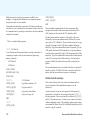
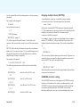
Overview of the match file
MatchRules define the variables for the address items found in
the reference street file attribute table. MatchRules use VAR
commands to specify variable names, field position, field length,
and missing value codes. You need a .mat file extension to specify
match rulesfor example, us_addr1.mat.
The VAR variable names cant contain more than 16 characters,
and the first character in the name must be a letter of the alphabet.
In addition, names are not case-sensitive, spaces arent allowed,
but underscores are permitted.
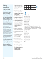
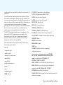
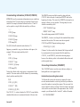
The Match (.mat) file
VAR
commands
MATCH
commands
VARTYPE
command
14
u probability
m probability
GEOCODING RULE BASE DEVELOPER GUIDE
VAR commands
VAR commands specify variable names, field position, and
missing value codes in the match file. As the graphic on the
previous page shows, VAR commands are listed in the match file
and are always prefaced with VAR.
Format
The format of the VAR command in the MatchRules should be as
follows:
VAR
<variable-name>
<beginning-column>
<length>
<missing-value code>
; comments
where <missing-value code> ::=
Sspaces
Zzero or spaces
Nnegative number (for example, -1)
9all nines (for example, 9999)
Xno missing value
An example of this is:
VAR StreetName 37 28 S
; Street name
In this example, the variable StreetName begins in column 37 for
length 28. The space or spaces represent valid missing values.
The text that follows a semicolon (;) is considered to be a
comment.
THE MATCH FILE
15
MATCH commands
You should use MATCH commands when you are defining match
rules for match variables. A number of MATCH commands are
available for specifying the comparison type, match key field,
variable name, matching probabilities, and additional parameters.
Reference file variable name
Format
The m probability is the probability that the field agrees, given
the record pair is a match (one minus the error rate of the field in a
matched record).
The format of the MATCH commands should be as follows:
MATCH
The variable name is defined in the VAR command.
m probability
<comparison-type>
u probability
<match key field>
The u probability is the probability that the field agrees at
random.
<reference file variable name>
<m-probability>
<u-probability>
[<additional parameters>]
[<mode>]
where <comparison-type> :=
CHARCharacter
D_INTLeft/Right intervals
LR_CHARLeft/Right character string comparison
LR_UNCERTLeft/Right uncertainty string comparison
NUMERICNumeric
UNCERTUncertainty character comparisons
INTERVAL_NOPARInterval without parity
Match key field
The two-character match key field is defined in the match key
dictionary (.dct) file.
16
For more information on the m and u probabilities, see the m and
u probabilities section in this chapter.
Additional parameters
A numeric value or values required for types UNCERT and
LR_UNCERT:
900 indicates that the two strings are identical
850 indicates that the two strings are so close they can be safely
considered the same
800 indicates that the two strings are probably the same
750 indicates that the two strings are probably different
700 indicates that the two strings are almost certainly different
Mode
The mode is required for types D_INT:
ZERO_VALID
ZERO_NULL
GEOCODING RULE BASE DEVELOPER GUIDE
EITHER
ZERO_VALID indicates that zeros or blanks should be treated as
any other number in that particular field.
For example, if ZERO_VALID appears in the {HN} field, as it does
in the example on the next page, any zeros in the house number
should be treated as an actual number.
ZERO_NULL indicates that zero is null and is never part of the
interval.
EITHER is required for types LR_CHAR and LR_UNCERT. It
indicates that it can match on either the left or right side. An
example of EITHER is shown in the MATCH commands below.
MATCH LR_UNCERT ZN ZipLeft ZipRight 0.9 0.01
700.0 EITHER
MATCH UNCERT SN StreetName 0.9 0.01 700.0
MATCH CHAR PD PreDir 0.8 0.1
MATCH CHAR PT PreType 0.7 0.1
MATCH CHAR ST SuffixDir 0.85 0.1
MATCH D_INT HN FromLeft ToLeft FromRight ToRight
0.999 0.05 ZERO_VALID
THE MATCH FILE
17
VARTYPE commands
The VARTYPE command comes after the MATCH commands in
the match file. The VARTYPE command indicates that frequency
analysis isnt performed. When you are modifying or creating a
match file, you shouldnt alter this line at all except to put in the
appropriate variables.
Format
The format of the VARTYPE commands should be as follows:
VARTYPE
<match variable name>
<action>
where
<action> ::=
NOFREQ (indicates that no frequency analysis should be
performed)
An example of this is:
MATCH LR_UNCERT ZN ZipLeft ZipRight 0.9 0.01
700.0 EITHER
MATCH UNCERT SN StreetName 0.9 0.01 700.0
MATCH CHAR PD PreDir 0.8 0.1
MATCH CHAR PT PreType 0.7 0.1
MATCH CHAR ST SuffixDir 0.85 0.1
MATCH D_INT HN FromLeft ToLeft FromRight ToRight
0.999 0.05 ZERO_VALID
VARTYPE FromLeft NOFREQ
In this example, FromLeft is the variable. The example also shows
that the VARTYPE command comes after the MATCH
commandsit should be the last command in the match file.
18
GEOCODING RULE BASE DEVELOPER GUIDE
m and u probabilities
MATCH commands require m and u probabilities.
The m probability is the probability that the field agrees to the
corresponding field in the standardized address, given the record
pair is a match. It can be defined as 1 minus the error rate of the
field in a matched record. Given this definition, if StreetName
disagrees 10 percent of the time in a sample of matched records
(for example, because of a transcription error or being
misreported), then the m probability for this variable is
0.9 (1 0.1). The more reliable a field is, the greater the m
probability will be.
You should provide an initial estimate of the m probability. Values
of 0.9 to 0.99 are typical, although any value from 0.1 through
0.999 is allowed. The closer this value is to one, the more critical a
disagreement on the field becomes. This means you can set fields
that are important to have a high penalty for mismatching. In your
initial estimates of the m probability, the estimates should tend to
be high. The fields that are the most important should have the
highest m probabilities associated with them, but you can have
the same values for each field if you want to give each field equal
weight. For more information on adjusting the m and
u probabilities, see Modifying the .mat file in this chapter.
In addition to providing an initial estimate of the m probability,
you should also estimate a u probability. In general, your
estimates here should be low, such as 0.01 or 0.1.
You can see an example of the m and u probabilities in the
following code sample. The m probability is the first number
immediately after each address element, and the u probability is
the number following the m probability.
MATCH LR_UNCERT ZN ZipLeft ZipRight 0.9 0.01
700.0 EITHER
MATCH UNCERT SN StreetName 0.9 0.01 700.0
MATCH CHAR PD PreDir 0.8 0.1
MATCH CHAR PT PreType 0.7 0.1
MATCH CHAR ST SuffixDir 0.85 0.1
MATCH D_INT HN FromLeft ToLeft FromRight ToRight
0.999 0.05 ZERO_VALID
The u probability is the probability that the field agrees to the
corresponding field in the standardized address, given the record
pair is unmatched. In other words, it is the probability that the
field agrees at random. The probability that the State (U.S.)
variable agrees at random is about 0.0004 if the State field in the
dataset contains all 50 unique values (50 states in the U.S.). Given
a uniform distribution, there are 2,500 (50 * 50) possibilities. The
State agrees in 1 of the 2,500 combinations (thus, 0.0004 u
probability).
THE MATCH FILE
19
Matching weights
Once you have estimated the probabilities for each field, you can
calculate the weight of each address element. If the fields agree,
the weight is the log to the base 2 of the ratio of the m and
u probabilities (positive weight). The equation is:
log2 m/u
If the fields disagree, then the weight is the log to the base 2 of
the ratio of 1m and 1u (negative weight). The equation is:
log2 1-m/1-u
A composite weight is computed by adding the individual
weights for all field comparisons together. The composite weight
provides users with a reference for how good a match is and from
this, a candidate score is computed. ESRIs geocoding software
products multiply the composite weight by 100 and use the result
as the candidate score. Each set of matched rules may generate
different scores depending on the number of rules defined and
the specifications of the m and u probabilities. It is important to
normalize the scores so that the perfectly matched candidate
always shows a score of 100. You have to specify the maximum
score as a factor for normalization in the address style file in
ArcView 3.x. However, ESRIs other geocoding products, such as
MapObjects, ArcIMS, and ArcGIS, normalize the score internally.
The score of each matched candidate is normalized to the range
of 0100 based on the computed maximum score.
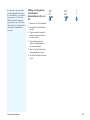
Examples of candidate scoring
Candidates
Composite Score
101
+
199
+
N
+
MAIN
+
ST
+
100
101
+
199
+
-
MAIN
+
ST
+
90
101
+
199
+
N
+
MAIN
+
AVE
-
85
101
+
199
+
-
MAIN
+
-
60
This table shows examples of candidate scoring based on the event
123 N MAIN ST. The higher the score, the better the match.
20
GEOCODING RULE BASE DEVELOPER GUIDE
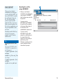
Modifying the
.mat file
The match (.mat) file is used to
adjust the weights of each
address element in determining
a match score. You can adjust
the values based on the
confidence you have in each
element of the address.
Adjusting the weight of
the StreetName element
1. Open the us_addr1.mat file in
the geocode folder in a text
editor, such as Notepad.
The .mat file will display.
u
1
In some instances, you may
want one of the address
elements to have a different
weight when determining the
match score. You can modify
the m and u probabilities in the
.mat file to adjust this.
For example, perhaps you arent
confident of the StreetName
element. If this is the case, you
may want to adjust the .mat file
so that the StreetName element
has less weight.
The .mat file is displayed.
This task illustrates how to do
this process using the
us_addr.mat file. A similar
process could be done using
other .mat files.
This task has also been
illustrated using a Windows
interface. The basic text editing
tasks could be performed in any
text editing software package. It
is advisable to make a copy of
the original file, modify the
copy, slightly change the name
of the original file, and change
the copys name to match u
THE MATCH FILE
21
the original name. This way, if
your modifications produce
undesired results, you can
restore the original file.
Tip
MatchRule syntax checker
The Developers Kit doesnt contain
a MatchRule syntax checker.
MatchRules must be visually
verified for correctness before they
are installed. If a MatchRule syntax
error is detected when the
MatchCase object is created,
creation of the MatchCase object
will fail.
22
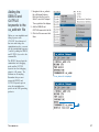
2. Change the m probability of
the StreetName to 0.8. This
reduces how much the
m probability adds to the
score, thus reducing the
weight of the
StreetName element.
2
3. Click the File menu and click
Save.
GEOCODING RULE BASE DEVELOPER GUIDE
The command file
IN THIS CHAPTER
• Overview of the command file
• Parsing parameters
4
The command file (.stn extension) is the file in the standardization
process that defines the standardization commands and processes, such as
us_addr.stn. This chapter gives an overview of the command file and shows
you the format of the file and the commands within it. It also describes the
parsing parameters, what they do, and how you can modify them.
• Adjusting parsing parameters
• Adding the DEBUG and OUTFILE
keywords to the us_addr.stn file
23
Overview of the command file
The command file specifies the standardization commands and
processes, such as us_addr.stn. The filename is always <file>.stn.
The format of the command file should be:
matched by each input case. This statement has to be removed
before the file is installed in ESRI geocoding products.
{<Parsing parameters> }
RECORD <record-size>
The <record-size> is the size of the record in characters. ESRI
geocoding products always use size 256.
The {<Parsing parameters>}, which are optional, are used to
override the default. For more information, see the section
Parsing parameters in this chapter.
TYPE <file-type>
An example of this is:
The <file-type> is the type of file. Always use ASCII.
us_addr.stn
RECORD 256
INTERACTIVE
TYPE ASCII
Always use Interactive.
INTERACTIVE
{DEBUG}
DEBUG
{DEBUG}, which is optional, is used to test the operation of the
pattern matching. Information about which patterns were matched
and what data was moved to the match key is printed either on
the standard output or on an output file if specified. This
statement has to be removed before the file is installed.
STANDARDIZE us_addr
OUTFILE us_addr.txt
STANDARDIZE <process>
The <process> is the process name, for example, us_addr. The
process name has to be the same name given to the .stn, .dct, .cls,
and .pat files in the same process.
{OUTFILE <output-file>}
The <output-file>, which is optional, contains the results of the
standardization, along with information about what patterns were
24
GEOCODING RULE BASE DEVELOPER GUIDE
Parsing parameters
Parsing parameters (SEPLIST and STRIPLIST) are rules that
define what constitutes a token or operand as defined in the
pattern file. The STRIPLIST is a list of characters or symbols to
be stripped during the standardization. By default, STRIPLIST
includes: ,.\`;:. The SEPLIST is a list of characters or symbols
used to identify separate tokens. By default, SEPLIST includes
()-/,#&;:. These default assumptions are overwritten by
specifying a new SEPLIST and a STRIPLIST. If no new lists are
specified, the default values are used.
A STRIPLIST and a SEPLIST must immediately follow the
STANDARDIZE statement to which they apply. The following
example demonstrates how you might set up SEPLIST and
STRIPLIST if you dont want to use the defaults.
Characters in the STRIPLIST or SEPLIST list must be enclosed in
quotation marks. The quotation mark itself may not be in either
list. Also, when you perform standardization, any character in the
STRIPLIST is removed as if it never existed. For example, periods
are stripped from the input records as if they never existed. Thus,
N.W. becomes NW and is considered to be a single word.
Characters in the SEPLIST are used to separate tokens. Hyphens
separate words, and each hyphen is considered a word in itself.
For example, 123-456 is three words (tokens): 123, the hyphen (-),
and 456.
Any character in both lists, such as a space, will separate two
tokens but will not appear as a token. One or more spaces will be
stripped, but the space indicates where one word ends and
another begins. Spaces are both stripped and separate tokens.
For example, 123 Main St consists of three tokens: 123, Main,
and St.
THE COMMAND FILE
25
Adjusting parsing
parameters
Parsing parameters are specified
by default in the command file.
However, in some cases, you
may wish to change what
characters are stripped or serve
as spaces. In this case, you
need to specify parsing
parameters in your .stn file. If
you want to accept the default,
do not specify any parsing
parameters. For a list of the
default parsing parameters, see
the section Parsing parameters
in this chapter.
1. Navigate to the .stn file you
wish to modify.
2. Right-click the file, point to
Send To, and click Notepad
or another standard text
editor.
3. After the STANDARDIZE
command in the .stn file, add
the parsing parameters.
4. Click the File menu and click
Save.
2
3
26
GEOCODING RULE BASE DEVELOPER GUIDE
Adding the
DEBUG and
OUTFILE
keywords to the
us_addr.stn file
1. Navigate to the us_addr.stn
file in Windows Explorer.
Right-click the file, point to
Send To, and click Notepad.
Before you can standardize and
debug a process with
STANEDIT, the software tool
that tests and debugs the
standardization rules, you must
edit the standardization process
*.stn file by adding the DEBUG
and OUTFILE keywords to the
command file.
3. Click the File menu and click
Save.
The us_addr.stn file displays.
2. Add the DEBUG and
OUTFILE keywords to the file.
1
The DEBUG keyword puts the
standardizer into debugging
mode, and the OUTFILE
keyword sets the debugging
output to <file_name>. The
filename can be anything.
Remember that you must
remove the DEBUG and
OUTFILE keywords prior to
using the standardization
process in the ESRI geocoding
products.
The us_addr.stn file is displayed.
2
THE COMMAND FILE
27
The match key dictionary
IN THIS CHAPTER
• Overview of the match key
dictionary
5
The match key dictionary (.dct extension) is the file in the standardization
process that defines information for the match key field. This chapter takes
you through an overview of the match key dictionary, then shows you how it
is formatted and how you can modify it.
• Modifying the match
key dictionary
29
Overview of the match key dictionary
The match key dictionary, which has a .dct extension, specifies
the fields that an address may be parsed into as a result of the
standardization. For example, a U.S. address contains the
elements of house number, prefix direction, prefix type, street
name, suffix type, and suffix direction. Thus, all these fields are
defined in the match key dictionary file. Each field is called a
match key. The match keys contain the values of the
standardization result and are used for matching against the
reference data.
The filename of the match key dictionary is always <file>.dct.
Each line of the dictionary represents a field of the match key. The
format is as follows:
<field-identifier> <field-type> <field-length> <missing value
code> [; <comments>]
where
<field identifier>
The field identifier is a two-character unique field name (not casesensitive).
<field type>
The field type defines how information is to be placed in the field.
C: character field; left-justified, filled with trailing blanks.
N: numeric field; right-justified, filled with leading blanks.
NS: numeric field; leading zeros are stripped.
M: mixed alphas and numerics; numeric values right-justified;
alpha values left-justified in the fields. Leading zeros are
retained if present. For example, 102 becomes b102, and A3
becomes A3bb, where b represents a space or blank.
30
MN: mixed name; field values beginning with a letter of the
alphabet are left-justified. Field values beginning with a
number are indented as if the number were a separate threecharacter field, for example:
MAIN
CHERRY HILL
bb2ND
b13TH
123RD
<field-length>
The <field-length> is the field length in characters.
<missing value code>
The <missing value code> is included for compatibility with the
interactive matching library. The user should simply code an X for
this operand.
X: no missing value
<comments>
Optional comments may follow a semicolon (;).
An example of this is:
\FORMAT\ SORT=N
HN
N
8
X; House number
PD
C
2
X; Predirection
PT
C
4
X; Pretype
SN
C
26
X; Street name
ST
C
4
X; Suffix type
GEOCODING RULE BASE DEVELOPER GUIDE
SD
C
2
X; Suffix direction
XS
C
4
X; Soundex of street name
XR
C
4
X; Reverse Soundex of street name
ZN
C
20
X; Zone
The first line of a match key dictionary should always be
\FORMAT\ SORT=N. No comments can precede this line.
THE MATCH KEY DICTIONARY
31
Modifying the
match key
dictionary
Adding match key fields
to the .dct file
The match key dictionary (.dct
file) is where the data type, field
length, and missing value code
for each match key field are
defined. In some cases, you
may want to add match key
fields to the .dct file or remove
ones that dont apply to your
address data.
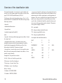
2. Add the fields you want to the
file—in this case, City and
State—and define the data
type, field length, and
missing value code.
1
1. Open the us_addr.dct file in
Notepad.
3. Click the File menu and click
Save when you are done with
your edits.
You can edit the match key
dictionary in any standard text
editor.
Remember that when you edit
the .dct file, you need to update
your .mat file accordingly.
When you update your .mat
file, remove any of the match
fields that you deleted in your
.dct file. Thats because if a
field is deleted in the .dct file
and is still in the .mat file,
problems will crop up when the
.mat file cant find the field to
refer to it. Do not rename the
match key names (that is, u
2
Tip
Adding fields to the .dct file
When you add fields to the .dct file,
you dont have to add them to the
.mat file if you dont plan to create
a match rule for the item you just
added.
32
GEOCODING RULE BASE DEVELOPER GUIDE
the field identifiers) unless you
are sure that the match keys are
not referred to by the pattern
(.pat) or match rule (.mat) files.
For more information on
modifying your .mat file, see
Chapter 3, The match file.
Tip
Removing fields from the
.dct file
Although you wont usually remove
fields from the .dct file, you may
decide at some point that some
fields arent necessary for standardization or matching. At that
point, you may decide to remove
them.
Removing fields from the
.dct file
1
1. Open the .dct file in Notepad.
2. Remove the field or fields
that you don’t want—in this
case, Zone.
3. Click the File menu and click
Save.
2
Zone has been removed from the .dct file.
THE MATCH KEY DICTIONARY
33
The classification table
IN THIS CHAPTER
• Overview of the classification table
• How to get to the classification
table
• How the classification table is
formatted
• Modifying the .cls file
6
The classification table (.cls file) is one component in the files that is
necessary to the standardization process. You can modify the .cls file so
that it is more useful to you. For example, if you wish to change how words
in your reference file are always standardized, you can edit the .cls file.
This chapter describes the .cls file in detail and gives examples of various
ways you can change it. The examples in the tasks come from the
us_addr.cls file, which is used in several of the US Streets address styles.
Because its the most commonly used, it is a good example, but remember
that with some of the address styles, it isnt used at all.
There are several other .cls files available, including:
us_intsc.cls, used for intersection matching for the US Streets styles
zip.cls and zip4.cls, used for ZIP5 style and ZIP5+4 style
stmap.cls, used for StreetMap standard house address matching
key_1.cls, used for the Single Field address style
city_cty.cls, used for City Country address style
city_st.cls, used for the City State address style
stm_int.cls, used for StreetMap intersection matching
us_addrc.cls, used for the US Alphanumeric Ranges styles
Remember that not all ESRI products include all styles by default. For
example, MapObjects only comes with us_addr.cls, zip.cls, and zip4.cls.
35
Overview of the classification table
<keyword>
<comparison threshold> is the degree of uncertainty that can be
tolerated in the spelling of the keyword, such as phonetic errors,
random insertion, deletion, replacements, and transpositions of
characters. The score is weighted by the length of the word, since
small errors in long words are less serious than errors in short
words. In fact, the threshold should be omitted for short words
since errors in them generally cannot be tolerated. The numeric
score operates roughly as follows:
<standardized abbreviation>
900exact match
<keyword class>
800strings are almost certainly the same
{<optional comparison threshold>}
750strings are probably the same
where
700strings are probably different
<keyword> is the keyword that may appear in an address. It must
be a single word.
An example of the classification table is:
The classification table (.cls extension) is used to identify and
classify keywords that may appear in an address, such as street
types (ST, AVE, BLVD) and directions (N, NW, S).
The filename of the classification table is always <file>.cls. The
classification table is a standard ASCII file with one line per entry.
Each entry contains:
EAST
E
D
E
E
D
NORTHWEST
NW
D
NW
NW
D
AVENUE
AVE
T
AVE
AVE
T
Examples of a <keyword class> include:
AV
AVE
T
0: NullOf, the, for, 0 (null) is a special class.
AVNUE
AVE
T
<standardized abbreviation> is the abbreviation used to
standardize various words of the same meaning. It would be
classified into the appropriate field in the match key. Each
abbreviation is limited to 25 characters in length.
<keyword class> is used in the pattern files to specify the rules
that will be used to interpret the elements of an address. A class
must be a single character.
800.0
800.0
D: DirectionEast, West, Southwest
T: Street typeAvenue, Street, Place
M: MultiunitApt, #, Suite, Room
B: BoxP.O. Box
O: OrdinalsSECOND, THIRD
C: CardinalsSIXTEEN, THREE
36
GEOCODING RULE BASE DEVELOPER GUIDE
How to get to the
classification
table
The classification table has a
.cls extension. Depending on
the application youre running,
you can access the .cls file for
editing from different places.
MapObjects 2.x, ArcGIS,
ArcView 3.x, and ArcIMS 4.x all
store the .cls files in different
places, but they all are similar in
that all of the files are stored in
one single flat directory with no
tree below it.
1. Locate the .cls file in
Windows Explorer.
2. Open the file in a text editor,
such as Notepad.
The file will display in
Notepad.
Note that if you would like to
use another text editor, such
as WordPad, you may do so,
but make sure you don’t save
the file with any extra
formatting.
If you are running MapObjects,
the .cls files are stored by
default in c:\program files
\esri\mapobjects2\georules\*.*.
2
If you are running ArcView 3.x,
the .cls files are stored by
default in
c:\esri\av_gis30\arcview
\geocode\*.*.
If you are running ArcGIS 9.0,
the .cls files are stored by
default in
c:\arcgis\geocode\*.*.
If you are running ArcIMS 4.x,
the .cls files are stored by
default in c:\arcgis\arcims
\indexbuilder\styles\*.* or
c:\arcgis\arcims\server\ext\
geocodeserver\styles\*.*.
The file displays in the text editor.
THE CLASSIFICATION TABLE
37
How the classification table is formatted
The classification table can be edited through Notepad or any
other standard text editor. However, before you can begin to edit
the .cls file, it is important to understand how the .cls file is
formatted.
The .cls file consists of three columns; some rows also have an
extra column with the comparison threshold. The first column is
the keywordthat is, the information you may find in an address,
such as EAST Avenue. All keywords in the file should be
uppercased, and each keyword must be unique. Only one entry of
Explanation of classes in .cls file
Example of some columns as they appear in the classification table
38
GEOCODING RULE BASE DEVELOPER GUIDE
the word is allowed in the table. Keywords cant contain spaces,
numbers, or symbols. For example, NORTH EAST and 3RD
are not valid keywords. The second column is the standardized
abbreviation. For example, if you enter the direction NORTH, it is
standardized to N. The output standardized value can be
anything you want, such as 3RD or MARTIN L KING. If the
value contains more than one word, enclose the words in double
quotes. All values should be uppercased. The third column is the
class. An explanation of the classes occurs at the top of the .cls
file. The optional fourth column is the comparison threshold, or
the degree of uncertainty that can be tolerated in the spelling of
the keyword.
THE CLASSIFICATION TABLE
39
Modifying the .cls
file
The classification table takes a
particular value in the address
and assigns it a standardized
abbreviation or value and a
token type value. You can use
the .cls file to add, remove, or
modify street directions, types,
and ordinal suffixes. For
example, if you dont want
AVENUE to be standardized
as AVE because your
reference data records AV as
the street type, you may change
it in the table. If you have some
particular street types used in
your databases, such as
CLOSE, that are not found in
the existing table, you can add
them to the table. For example, a
new line like this:
Modifying the .cls file to
change standardization
of ordinal suffixes
1. Open the .cls file in Notepad.
2. Scroll down to the ordinal
numbers you wish to change,
for example, FIRST.
3
3. If you wish to change your
data so it is standardized as
a full word (rather than the
numeral), change the second
column to the full word.
4. When you are done editing
the .cls file, click the File
menu and click Save.
CLOSE CLOSE T
can be added to the table.
When editing the .cls file,
remember that any changes you
make will be universal. If you
wish to make a change in a
special case (for example, filter
for North Bend in a way that
lets North be a part of the
address for this address, but
leaves it as a direction in all
other cases), you can add a
special routine to the .pat file.
For more information, see
Chapter 7, The pattern file.
40
GEOCODING RULE BASE DEVELOPER GUIDE
If your address data and
reference data use different
abbreviated values, you may
need to modify how the term is
abbreviated. The second
column should match the format
used in the reference material.
Modifying the .cls file to
change AVE to AV
1. Open the .cls file in Notepad.
2. Scroll down to Avenue (use
the Find tool in the Edit
menu).
3
3. Change the text in the
second column from AVE to
AV.
4. Click the File menu and click
Save.
THE CLASSIFICATION TABLE
41
In certain cases, some prefix
values should not be removed
from the name (for example,
Calle Real) but are. This is
because the rule base sees
these words as prefix street
types. You can fix this in the
.cls file so these words are
classified as part of the street
name.
Removing Spanish street
types for datasets that
store prefix types in the
street name field
3
1. Open the .cls file.
2. Scroll down to Avenida.
3. Comment out Avenida by
placing a semicolon in front
of it.
4. Repeat the process with
Calle and Paseo, if desired.
5. Click the File menu and click
Save.
42
GEOCODING RULE BASE DEVELOPER GUIDE
In some cases, you may have
an unrecognizable street type.
In a case like this, you can add
the type to the .cls file, standardize the third column as a
type, and save the .cls file. By
doing this, you ensure that the
words will be standardized
correctly.
Adding new keywords
and standard
abbreviations to the .cls
file
3
4
5
1. Open the .cls file in Notepad.
2. Scroll down to the bottom of
the file.
3. Type the words you want to
add (for example, Close) in
the first column.
4. Type the words as they
should be standardized in
the second column.
5. Type a T in the third column
to standardize as a type.
6. Click the File menu and click
Save.
THE CLASSIFICATION TABLE
43
When you are dealing with
abbreviations for names of
streets (for example, MLK or
JFK), you may notice that all
your candidate matching
scores are low. This may be
because the .cls file is standardizing the abbreviation to
something other than what is in
the reference data file. In other
words, if the .cls file is standardizing MLK to MARTIN
LUTHER KING, but the reference file contains MLK, the
match score will be low because
it wont be able to find the
street name. To fix this problem,
you can edit the .cls file so that
MLK is standardized to MLK,
and MARTIN LUTHER KING is
standardized to MARTIN
LUTHER KING.
Changing abbreviated
names in the address
data to match data in the
reference files
2
1. Open the .cls file in Notepad.
2. Scroll down to MLK.
3. Change the second column
from MARTIN LUTHER KING
to MLK.
3
4. Click the File menu and click
Save.
Your address data should
now be the same as your
reference file data, which will
result in much better
candidate scores.
Similarly, you may run into this
sort of trouble when you are
working with instances of ST.
ST is a special case, since it can
represent Street, Saint, the st in
ordinal numbers (first, twentyfirst, and so on), or Suite. The
classification table is not the
best place to deal with instances of ST, because it cant
take different situations into
account. Instead, it is handled
in the pattern rules. For more
information on dealing with
instances of ST, see Chapter 7,
The pattern file.
44
GEOCODING RULE BASE DEVELOPER GUIDE
The pattern file
IN THIS CHAPTER
• Overview of the pattern file
• Pattern rules
7
The pattern file (.pat extension) is critical to the standardization process
because it defines pattern rules and actions. This chapter looks at how the
pattern file is set up, examines the different rules and actions that are
available, and shows you how to modify the pattern file.
• Actions
• Modifying the pattern file
• Dealing with street intersections
• Editing intersection .xat/.pat files
• Adding custom routines to the
pattern file
45
Overview of the pattern file
The pattern file (.pat extension) contains pattern rules and actions
for standardizing an address and converting the recognized
operands into match key fields.
The pattern file defines patterns to identify all elements of an
address by keywordsfor example, 123 North Main Avenue. This
address can fit into the pattern:
The example below shows the three parts of the pattern file. The
POST action section is optional and contains actions that are
executed after patterns in the main section and subroutines are
processed for the record. The pattern/action section shows that
patterns and actions must be grouped together. This section can
contain as many patternaction sequence pairs as are necessary.
The last section shows where subroutines are located.
Numeric : 123
Direction : North
Unknown word or words : Main
Street Type : Avenue
<post-execution actions
A pattern rule uses a pattern recognition syntax that will be
discussed in detail in this chapter. A pattern rule is constructed in
the form of a list of operands (that is, a representation of a token)
separated by vertical bars. For example, a pattern of the above
address would be
\POST_END
^|D|?|T
\POST_START
<pattern>
<action>
<pattern>
<action>
\SUB <action>
\END_SUB
D and T classes are defined in the classification table. Each
operand is referenced by an operand number. The above example
contains four operands. The first operand is Operand [1], the
second is Operand [2], and so on.
Actions defined after the pattern rule are executed to convert the
value of the specified operand referred by its number to the match
key fields. The match key fields were defined in the match key
dictionary. The match key fields for the given example are:
Numeric : {HN}
Direction : {PD}
Unknown word or words : {SN}
Street Type : {ST}
46
GEOCODING RULE BASE DEVELOPER GUIDE
Given the pattern, actions following the pattern rule for this
address are:
COPY [1] {HN}
COPY_A [2] {PD}
COPY_S [3] {SN}
COPY_A [4] {ST}
The first action copies the value in Operand 1 into the HN match
key, that is, 123 in this example. The second action copies the
abbreviated value of Operand 2 into the PD key, that is, N. Note
that N was defined in the classification table as the
standardized value for the keyword NORTH. The third action
copies the entire string, including spaces in Operand 3, into the
SN key, that is, MAIN. The last action copies the abbreviated
value of Operand 4 into the ST key, that is, AVE as defined in the
classification table for the keyword AVENUE.
To be correctly interpreted and moved to the match key fields, an
address may require more than one pattern. Because of this,
subroutines of pattern matching are allowed. An example of this
comes when you need to define patterns to filter apartment units
and standardize the rest for 123 N Main St Apt 101. To do this,
you would use:
\SUB APTS
; patterns & actions for processing apartment
units
\END_SUB
The pattern file is a rule base file. Each rule is fired sequentially,
unless it goes to a subroutine. The system will try to match the
address to the first pattern. If it matches, the actions following the
pattern will be executed. If it doesnt match the pattern, it will
proceed to the next pattern, and so on. If the matched pattern
doesnt end with an EXIT or RETURN action, it will continue
to match to the next pattern. Subroutines can be introduced in the
main section of the pattern file. Rules defined in the subroutines
will be matched sequentially, unless a RETURN action is
executed or when it reaches the end of the routine. After the
subroutine is processed, the system will return to the previous
location in the patternaction sequence. When an EXIT action is
executed or when it reaches the last pattern in the pattern file, the
entire process will end.
The pattern file needs to be encrypted before it is installed. You
can use the Standardizer Editor (STANEDIT) or the encodpat.exe
program to encrypt the file. For more information on STANEDIT
and ENCODPAT, see Chapter 8, Developers Kit tools.
%1M ; M is a class for apartment units
CALL APTS
^ | D | ? | T
COPY [1] {HN}
COPY_A [2] {PD}
COPY [3] {SN}
COPY [4] {ST}
EXIT
THE PATTERN FILE
47
Pattern rules
There are two types of pattern rules: unconditional and
conditional. Unconditional patterns are strict rules that are not
sensitive to the values of the operands. Conditional patterns
allow patterns to match only under specified circumstances.
As this pattern demonstrates, each of the words in Martin Luther
King is tokenized into a +.
Unconditional patterns
The > token matches to 123A (because a numeric is leading), the ?
token matches to Main (the unknown), and the T token matches
to the type.
The following are some simple pattern classes:
AZ: Classes supplied by user from classification table
^: Numeric
?: One or more consecutive unknown alpha words
+: A single alphabetic word
&: A single token of any class
The pattern represented by 123A Main St can be coded as:
>|?|T
The leading alphabetic class, which is represented by <, matches
to patterns represented with a leading alphabetic character. For
example, the pattern represented by ABC123 New York Ave would
be coded as:
<|?|T
@: Complex mixed, for example, 6H46K
The complex class, which is represented by @, matches those
tokens having a complex mixture of alphabetics and numerics, for
example, A123B. So, the pattern represented by A236C Crosier
Blvd would be coded as:
-: Hyphen
@|?|T
>: Leading numeric, for example, 3EBA
<: Leading alphabetic, for example, A501
The null class (0) is a special class that is used either in the
classification table or in the RETYPE action to make a token null.
Since it never matches to anything, it would never be used in a
pattern. An example of using RETYPE to make the token null is:
-T | + | +
RETYPE [2] 0
; Avenue of America
; removes the word of
Special single character classes
In some instances, a pattern may be represented by numeric or
alphabetic characters that contain hyphens or slashes. The
hyphen (-) and slash (/) are special single character classes.
Some examples of special single character classes are:
The pattern represented by the address 123 N State St can be
coded as:
^|-|^
^|D|?|T
In these examples, the ^ represents a numeric, and the - or /
operands represent the - or / in the pattern.
A single alphabetic word can be matched with a + class. This is
useful for separating the parts of an unknown string. For example,
the pattern represented by Martin Luther King can be coded as:
; 123-127
^ | ^ | / | ^ ; 123 1/2
+|+|+
48
GEOCODING RULE BASE DEVELOPER GUIDE
Single token
Subfield ranges
A single token of any class is represented by the ampersand (&).
Subfield ranges (beg:end) specify a range of unknown words:
An example of this is:
(1:3) specifies words 13 of an unknown string.
* M | & ;Apartment 3G, Room 45
(-3:-1) specifies the third-from-the-last to the last word of an
unknown string.
End of field
(1:-1) specifies the first to last word of an unknown string
(however, using ? is more efficient).
The $ specifier matches to the end of the field instead of
matching to any real token. It is used to ensure that no tokens are
left in the field after the pattern.
Her is an example of how the $ specifier is used:
*^ | $
;tests only 92373 of CA 92373
Subfield classes
The subfield classes (1 to 9, -1 to -9) are used to pick off
individual words of a ? string.
1 = the first word
For example:
^ | - | (1:2)
;123 - A B Main St
COPY [3] {HS}
results in AB being moved to the {HS} match key field.
Universal class
The universal class (**) matches all tokens. For example, a
pattern of ** would match 123 MAIN ST.
-1 = the last word
The universal class can be combined with other operands to
restrict the tokens grabbed by the class. For example, the pattern
123 N Main St would be coded as:
-2 = the next to last word
** | T
If the referenced word doesnt exist, for example, ^ | - |2 for 123-A
where there is no second word in the column, the pattern doesnt
match.
The universal class deals with everything before the type, which
may be no tokens. In this example, the universal class represents
the ^ and ? tokens. In this case, Operand [1] = 123 N Main, and
Operand [2] = St.
2 = the second word
Subfield classes are useful for processing address suffixes, such
as 123-A MAIN ST.
The pattern ^ | - | 1 would match as follows:
[1] = 123
[2] = [3] = A
THE PATTERN FILE
Floating positioning specifier
The floating positioning specifier (*) is used to modify the
positioning of the pattern matching. The class immediately
following it is a floating class. The pattern is searched until there
is a match or the entire pattern is scanned. For example:
* M | ^
;123 Main St Apt 34
49
Operand [1] = Apt (M is a class for Apt defined in the
Classification Table)
You can qualify the positions by following the %n with a token
type. Each token is treated according to its type:
Operand [2] = 34
%2^ = the second numeric token
This pattern can be used to filter out the apartment number
information by retyping it to a null class. Essentially, it removes it
from consideration by any patterns that appear further down the
file of patterns.
%3T = the third type token
It is important to remember that the asterisk must be followed by a
class, for example, * M or * ^.
Reverse floating positioning specifier
The reverse floating positioning specifier (#) is similar to the
floating positioning specifier (*), except that scanning proceeds
from right to left instead of from left to right.
This specifier (%) is only permitted as the first operand of a
pattern, since it is used to position the patterns.
For example, John Doe 123 Martin Luther St Salt Lake:
%1 1 matches to the John, the first word of the first string.
%3+ matches to the third single alpha word, Martin.
Negation class qualifier
The negation class qualifier (!) indicates NOT.
The specifier can only appear in the first operand of a pattern,
since it is used to position the pattern. For example:
So, !T means not Type and will match to any token except a street
type. For example, * M | !T matches to SUITE 3 but not to SUITE
STREET.
#S | ^ ;California 45 Products, Phoenix Arizona
85042 (Class S for State names)
The negation class may be combined with the floating class (*)
only at the beginning of a pattern.
would scan from right to left for a state name followed by a
number.
Operand [1] = Arizona
Operand [2] = 85042
*!? | T =T= ST | +
;ST CHARLES ST
RETYPE [2] ? SAINT
;expands ST to SAINT
This pattern matches to the string ST CHARLES, and ST will be
expanded to SAINT.
Fixed position specifier
The fixed position specifier (%n) specifies the position at a
particular operand in the input string.
%1 = the first token
%2 = the second token
%-1 = the last token
%-2 = the second-from-last token
50
GEOCODING RULE BASE DEVELOPER GUIDE
Conditional patterns
Conditional patterns allow patterns to match only under
specified circumstances. For example, T | ? matches to both ST
CHARLES and AVENUE OF THE AMERICAS, where ST and
AVENUE were defined as being in a T class in the classification
table.
The actions required in both of these cases are different. In the
first case, the ST refers to SAINT, and in the second case the
AVENUE is the real street type.
Providing conditional values in patterns can correctly process
such problem cases.
Simple conditional values
With simple conditional values, the operand is always followed
by an equal sign and a value. The equality operator (=) tests both
the standardized abbreviation and the original token value for
equality to the operand.
When using simple conditional values, alphabetic values must
always be in double quotes. However, numeric values are coded
without quotes. An example of this is:
*T = ST | +
;ST. CHARLES
D = S
; any direction with the standard
abbreviation S.
Sometimes, operands are followed by =A= or =T=. In this case,
=A= only tests the abbreviation, while =T= only tests the original
token value. Some examples of this type of scenario are:
*T =T= ST | + ;test to see if ST was actually
coded.
RETYPE [1] ? SAINT
D =A= E ;test the abbreviation regardless if
the original word was EAST or E.
Series of conditional values
A series of conditional values is specified by delimiting the
entries. The entries can be delimited using either spaces or
commas. So, for example, the conditional values can be specified
either by:
T = ST , AV, PL
or:
T =A= ST AV PL
A series of values can be tested against the match key in a similar
fashion. For example:
RETYPE [1] ? SAINT
^ | T | {SN} = MAIN, ELM, COLLEGE
This is a street type whose value is ST followed by an unknown
string.
If you are testing a matching key, the test must follow all pattern
operands, including end of field.
The value to be compared is based on both the standard
abbreviationif one existsand the complete word. This is
useful because it prevents you from having to code all possible
values.
D = SOUTH
; the word SOUTH is in the
classification table.
THE PATTERN FILE
Tables of conditional values
A large number of conditional values can be specified in
additional tables. For example, you may want to use tables when
you have titles for streets (such as General John Doe, General J D,
and General J Doe), but all these titles refer to the same street.
51
The table parses the field to make sure its part of the list in the
table. You can specify tables as follows:
{<match key name>}
@<table file name>
Relational operators in conditional expressions
The table is an ASCII file that has one line for each conditional
value.
<arithmetic-expression>
<
original token is less than
>
original token is greater than
=
abbreviation or original
token is equal to
For example:
=A=
abbreviation is equal to
^ | T | {SN} = @strtname.dat
=T=
original token is equal to
When you are testing a match key, the test against a table of
values must follow all pattern operands, including an end-of-field
operand.
means that the table strtname.dat is examined to check if the value
in the SN key is found in the table.
<=
>=
Conditional expressions
A conditional expression is enclosed in square brackets
immediately following the pattern operand. It can be either a <leftoperand>, a <relational-operator>, or a <right-operand>.
Operands can be a variable name, the match key contents for the
current operand, the match key contents for any field, a literal, a
constant, or the special variables LEN and PICT.
!=
original token is less than or
equal to
original token is greater than
or equal to
abbreviation and original
token are not equal to
!=A= abbreviation is not equal to
!=T=
original token is not equal to
Referencing current operand contents
Left operand in conditional expressions:
You need to reference current operand contents when you need
to reexamine special cases in the current operand.
variable name
?|S|^[{} > 50000]
{}
{} PICT
{} LEN
{<match key name>} PICT
{<match key name>} LEN
variable name PICT
;Zip code > 50000
The special operand {} indicates the contents of the current
operand.
When character literals are in an equality test, the standard
abbreviation is tested, if one is available. If this fails, the original
input is tested. Some examples of this are:
T[{}= ST] ;tests the abbreviation because ST
is listed in the classification table.
variable name LEN
52
GEOCODING RULE BASE DEVELOPER GUIDE
T[{}= STREET] ;tests the entire word STREET
since it is not an abbreviation.
When comparisons other than the equality operators are
specified, for example, T [ {} <= ST ], the original input is used
rather than the abbreviation.
Referencing match key contents
When you are evaluating the match key for a particular instance
only, such as {ZP}for ZIP Code, you are referencing match key
contents. This specifies the match key field name enclosed in
braces. For example:
^|D=E|D=W|T=HWY|[{ZP}>=20100&{ZP}<=20300]
;123 East West Highway, ZP=20200
Referencing constants, literals, and variables
You can reference constants, literals, and variables.
Numeric constants are referenced by coding a number. Negative
numbers and decimal points are not permitted in numeric
constants.
An example of a reference of a numeric constant is:
^ [{}=10000]
Literals are character constants. They are represented by
enclosing a string in quotes.
A null or empty value is indicated by two consecutive quote
marks:
? [{}=]
Variables can be given any name desired. However, the name
cant exceed 32 characters, and the first letter must be alphabetic.
After the first character, any combination of alphabetics, digits, or
underline characters may be used. A variables type is numeric if it
THE PATTERN FILE
is set to a numeric value. If it is set to a literal value, its type is
character. For example:
[postcode = 12345]
;postcode is a variable.
Referencing the length of an operand
A LEN qualifier represents the length of an operand:
{} LEN: Length of current operand
<variable> LEN: Length of contents of variable
{<match-key-field>} LEN: Length of match key field
For example:
^[{}LEN = 5]|-|^[{}LEN = 4] ;search for a nine
digit ZIP of the form 12345-6789.
If the numerics do not match the length of the operand, the
pattern will not match. Some other examples of the LEN qualifier
are:
?[temp LEN = 5] ;test the length of a variable.
[{SN} LEN = 20] ;test the length of a match key
field.
Referencing a template of an operand
The PICT (picture) qualifier tests the special format of an
operand:
<[{}PICT = ccn]|>[{}PICT = ncc]
;for
testing English postal codes, e.g. AB3 5NW
The PICT defines how the numerics and alphabetics are
distributed. ccn means character-character-number, and ncc
means number-character-character.
Only the equality (=) and inequality (!=) operators may be used
with PICT comparisons.
53
Referencing a substring of an operand
Available arithmetic operators:
You can reference a substring of an operand to solve several
situations. For example, this is useful when you are testing
variables or match key fields. The following shows the format of
referencing a substring of being an operand and some examples
of how it would actually be used.
+ addition
{} (beg:end): Substring of current operand
% modulus
<variable> (beg:end): Substring of contents of variable
A right-arithmetic-operand may be:
{<match-key-field>} (beg:end): Substring of match key field
variable name
where:
constant
(beg:end) = the beginning and ending columns
Arithmetic is limited to one operation per expression. No
parentheses are permitted.
1= the first column of the string
-1= the last column of the string
-
subtraction
* multiplication
/
division
Examples:
+[{(-7:-1) = STRASSE]|^ ; HESSESTRASSE 15
^[{}/3 > temp] ;value in variable temp is 2 (in
which case value in the ^ token should be greater
than 6 in order to match this pattern)
[temp(2:4) = bcd]
;tests a variable
^[{}%2 = 0]
[{SN}(1:4) = FORT]
;tests a match key field
Some examples of this are:
Separating spaces are removed by the parsers when testing
substrings on multitoken values.
;even numbered houses
Combining conditional expressions
Conditional expressions may be combined using the logical
operators:
Arithmetic expressions
&: and |: or
Arithmetic expressions can be <left-arith-operand>, <arithoperator>, or <right-arith-operand>.
All operations are executed left to right.
A left-arithmetic-operand may be:
variable name
{ <match key name>}
{}
54
Some examples of combined conditional expressions include:
^[{}>=1000 & {}<=10000]
range of 1000 to 10000
;house number in the
^[{}<100 | {}>1000] ;house number less than 100
or greater than 1000
Vertical lines within the square brackets are logical OR operations,
and those outside the brackets are operand separators.
GEOCODING RULE BASE DEVELOPER GUIDE
Actions
Whenever a pattern matches, a series of associated actions is
performed. Actions can be used for many things, including
filtering noise, converting an operand to other values based on a
lookup table, copying a value or operand to a match key field or a
variable, or invoking a subroutine.
Action commands must always be in uppercase.
Copying information (COPY)
where b is the beginning letter of the string and e is the ending
letter. For example:
+ | ^
; HESSESTRASSE 15
COPY [1](1:5) {SN}
COPY [1](-7:-1) {ST}
COPY [2] {HN}
Copying leading/trailing characters
The COPY command copies the entire string (all words are
concatenated). There are no intervening spaces. The form of the
COPY command is a <source> and a <target>.
You can also copy leading or trailing characters. There are four
possible mixed operand specifiers:
The <source> can be an operand, substring operand, mixed
operand, user variable, match key field, literal, or constant.
(n)
all leading numeric characters
(-n)
all trailing numeric characters
The <target> may be a match key field or user variable.
(c)
all leading alphabetic characters
For example:
(-c)
all trailing alphabetic characters
^ | ? | T
;123 MAIN ST
For example:
COPY [1] {HN}
> | ? | T ;123A MAIN ST
COPY [2] {SN}
COPY [1](n) {HN}
COPY_A [3] {ST}
COPY [1](-c) {HS}
EXIT
COPY [2] {SN}
This patternaction sequence will produce the result:
COPY_A [3] {ST}
{HN} = 123
EXIT
{SN} = MAIN
{ST} = ST
Copying substrings
A substring of an operand can be copied using the substring
operand form. This form is:
COPY <source>(b:e) <target>
THE PATTERN FILE
Copying user variables
A user variable may be the target and/or the source of a COPY.
The type of target user variable is determined by the type of the
source. Some examples of this are:
COPY [1] temp ;copy an operand
COPY SAINT temp ;copy a literal
COPY temp1 temp2 ;copy a variable
55
Copying match key fields
You can copy match key fields to other match key fields. One
example of this is:
COPY {HN} {HC}
In this example, the value of {HN} is copied to {HC}.
Copying standardized abbreviations (COPY_A)
You can copy the standardized abbreviation coded in the
classification table for an operand to a target. The target can be a
match key field or a user variable. For example:
^ | ? | T ;123 DAYTON AVENUE
COPY [1] {HN}
COPY [2] {SN}
You can use this command to move a user variable or a match key
field to another match key field. For example, you could do one of
the following:
MOVE {HN} {HS}
MOVE temp {SN}
Concatenating information
You can concatenate information using either the CONCAT
command or the PREFIX command. The CONCAT command
concatenates information to a user variable or a match key field.
The source can be an operand, a literal, or a user variable. For
example:
^|D=E|D=W|T=HWY|[{ZP}>
=20100&{ZP}<=20300]
COPY_A [3] {ST} ;copy AVE instead of AVENUE
;123 East West Highway, ZP=20200
Copying with spaces (COPY_S)
COPY [2] temp
(COPY_S) preserves spaces between words when you copy
them. An example of this is:
CONCAT temp
CONCAT [3] temp
;concat EAST WEST
^ | ? |T ;123 OLD CHERRY HILL RD
COPY temp {SN}
;move to street name
COPY [1] {HN}
COPY_A [4] {ST}
;move HWY to street type field
COPY_S [2] {SN} ;OLD CHERRY HILL
You can also concatenate the standard abbreviation of the
operand using CONCAT_A.
COPY_A [3] {ST}
Moving information
When you use move information (MOVE), the source is erased
(made null) after it is moved. This action is similar to COPY, but
COPY doesnt erase the source after the value is copied.
56
COPY [1] {HN} ; move house number to {HN}
The PREFIX command adds the concatenated operand to the
beginning of a string.
PREFIX_A lets you prefix the standard abbreviation instead of
the raw data. The source must be an operand.
GEOCODING RULE BASE DEVELOPER GUIDE
Converting information (CONVERT)
When you use RETYPE, the format should be as follows:
CONVERT lets you convert data according to a lookup table or a
user-supplied literal.
RETYPE <operand> <class> [<variable> | <literal> ] [<variable> |
<literal> ]
The following graphic is an example of the ASCII file codes.tbl:
You can also retype an operand to a null (0) class to filter or
remove the information. For example:
001
"SILVER SPRING"
%M | &
;123 MAIN ST APT 56
002
BURTONSVILLE 800.0
COPY_A [1] {UT}
003
LAUREL
COPY [2] {UV}
RETYPE [1] 0
;removes APT
The first column above is the input value, and the second column
is the replacement value. As you can see, multiple words are
enclosed in double quotes.
RETYPE [2] 0
;removes 56
Optional weights may follow the second operand to indicate that
uncertainty comparisons may be used.
*!? | T = ST | +
An example of how to use CONVERT is:
& ; any token
CONVERT [1] @codes.tbl TKN
TKN indicates that the token will be changed permanently for any
pattern and/or action sets further down the current pattern file or
for another process if that process uses the same token table. It
will remain permanent until you finish the task. If you only want
the conversion applied to the current set of actions, use TEMP
instead.
Retyping operands (RETYPE)
RETYPE can be used for several different things. You can change
the type of an operand in the token table, change the value of an
operand, or change the abbreviation of an operand if it is found in
the classification table.
THE PATTERN FILE
If you want to change the token type and replace the text of a
token, use RETYPE:
RETYPE [2] ? SAINT ;changes the token type to ?
and replaces ST to SAINT
When changing the standard abbreviation of the operand:
T=A=ST | ^
RETYPE [1] M SUITE STE ;changes the
standard abbreviation of SUITE to STE
Retyping multiple tokens (RETYPE)
When you are retyping multiple occurrences of a token, use
<num>*<class> followed by a standard RETYPE statement
referencing operand [1]. The number, which indicates the number
of occurrences referenced, must be an integer from 0 to 255. Zero
means that all occurrences should be scanned. An example of this
is as follows:
0 * -
;123-45 MAIN ST
RETYPE [1] 0
;removes all hyphens from tokens.
57
Soundex phonetic coding
COPY_A [3] {ST}
Soundex codes are phonetic keys that are useful for blocking
records in a matching operation. For more information about
Soundex encoding, see Chapter 1, Introduction.
EXIT
Soundex computes a Soundex code of a match key field and
moves the results to the target match key field. The format should
be as follows:
Subroutines facilitate fast processing and can be invoked by a
CALL action. Subroutine names should contain between 1 and
32 characters, the first character of which must be alphabetic. The
format should be as follows:
Soundex <source-field> <target-field>
For example:
Soundex {SN} {XS}
In addition to Soundex, you can also use reverse Soundex
(RSOUNDEX). RSOUNDEX is useful for blocking on fields where
the beginning characters might be in error. With reverse Soundex,
the phonetic code is generated from the last nonblank character
of the field and proceeds to the first.
These two actions are generally used in the POST action section
so that they are executed after pattern matching is complete for
the record.
Terminating pattern matching (EXIT)
When you are using EXIT, you can quit the pattern matching
program for this process in this record. This prevents further
patternaction pairs from being executed.
Subroutines
CALL <subroutine>
For example:
%1 M
CALL APTS
Writing subroutines (SUB, END_SUB)
Subroutines always need to have a header and a trailer line:
\SUB <name>
subroutine body
\END_SUB
Subroutines should always be coded at the end of the file.
However, the order of the subroutines is unimportant. CALL
actions are not permitted from within subroutines.
^|?|T
Control is returned back to the main program either when the
\END_SUB is reached or when a RETURN action is executed. For
example:
COPY [1] {HN}
%1 M |^
The following example demonstrates how EXIT can be used:
COPY_S [2] {SN}
CALL APT
\SUB APT
patterns and actions for processing apartments
\END_SUB
58
GEOCODING RULE BASE DEVELOPER GUIDE
Returning from a subroutine (RETURN)
The RETURN action returns control from a subroutine to the main
program. For example, in SUB_APTS:
M | ^
RETYPE [1] 0
RETYPE [2] 0
RETURN
THE PATTERN FILE
59
Modifying the
pattern file
Some examples of things you
can do in the pattern file
include adding quickly filterable
patterns, modifying existing
rules to handle address pieces,
adding custom routines,
processing a specific case, and
editing the intersection .xat/.pat
files.
You dont make edits directly to
the pattern file. Instead, you
need to open the .xat file, which
is the ASCII version of the file,
make edits to it, then encode
the .xat file to create a new .pat
file. You can encode the .xat file
using ENCODPAT.exe, one of
the tools in the Geocoding
Developers Kit. For more
information on ENCODPAT.exe,
see Chapter 8, Developers Kit
tools.
Encoding the .xat file
1
1. Open the .xat file you wish to
modify in Notepad. The .xat
files are located in the
geocode subfolder of the
Geocode folder.
2. Make any changes in the .xat
file.
3. Click the File menu and click
Save.
4. Open STANEDIT.
5. Click the File menu and click
Open Process.
4
6. Click the .stn file you wish to
use (has the same filename
as the .xat file you modified).
7. Click the Tools menu and
click ENCODE PAT.
ENCODE PAT converts the
.xat file into a binary file with
the .pat file extension.
This section demonstrates
some of the modifications you
can make in the pattern file.
They cover some of the most
frequent issues that come up.
You can also study them to see
how the changes are made and
apply what you see to your
own situation.
60
GEOCODING RULE BASE DEVELOPER GUIDE
You can add quickly filterable
patterns to the top of the .xat
file, then EXIT. This lets you
easily modify patterns. This
task uses the example of the
address 123 23rd St. Ct. as an
example.
Adding quickly filterable
patterns to the pattern
file
1. Note in the address:
123 23rd St. Ct.
that 23rd St. represents the
street name, and Ct.
represents the street type.
2. Open the us_addr.xat file in
Notepad.
3. Add the following pattern at
the top of the .xat file:
Pattern is:
^ | & | S | T ;
standard form of 123 23rd
St. Ct.
COPY 1 {HN}
COPY 2 temp
CONCAT temp
CONCAT_A [3] temp
COPY temp {SN}
COPY_A [4] {ST}
EXIT
4. Click the File menu and click
Save.
5. Open STANEDIT (for
information on using
STANEDIT, see Chapter 8,
‘Developer’s Kit tools’).
6. Click the Tools menu and
click ENCODE PAT.
The .xat file is converted to a
binary .pat file.
THE PATTERN FILE
61
Sometimes, you may work with
a particular address that
doesnt follow the standard
rules. For example, in the case
of the address 235 Trail West
Street, West is part of the street
name. In this instance, you
need to modify the .xat file so
West is included as a street
name for this instance but
remains a direction for all other
instances.
Modifying the .pat file for
a special circumstance
2
1. Open the us_addr.xat file in
Notepad.
2. To quickly process the
special case for “Trail West”,
add a section to the top of the
.xat file with the pattern
outlined in the graphic to the
right.
3. Click the File menu and click
Save.
4. Open STANEDIT.
5. Click the Tools menu and
click ENCODE PAT.
The .xat file will be converted
to a binary .pat file.
62
GEOCODING RULE BASE DEVELOPER GUIDE
The classification of ST is often
tricky. ST can stand for Street,
Saint, ordinal numbers (for
example, 1ST), or Suite and is
tokenized and classified
differently for each one.
Dealing with ST
The us_addr.pat file has been
set up to handle the various
meanings of ST. If you are
setting up a new process and
will need to handle ST, you can
use the us_addr file as a guide.
2. Right-click the .xat file, point
to Send To, and click
Notepad (or another
standard text editor).
1. Navigate to the .xat file you
wish to modify (default
location is C:\programfiles\
ESRI\GeoKit\Geocode).
3
4
3. Add the text in the example at
the right to the top of your .xat
file.
4. Add the text in the example at
the right to your .xat file after
your pattern–action
sequence pairs.
5. Click the File menu and click
Save.
6. Open STANEDIT (default
location is C:\program
files\ESRI\Geokit\Bin).
7. Click the File menu, click
Open Process, and click the
process you are working on
(same filename as the .xat
file you modified).
8. Type an address to be
standardized in the text box.
9. Click the Tools menu and
click Encode PAT.
9
The .pat file is outputted to
your geocode folder where
the software is installed (for
example, if you are using
ArcGIS, the default location is
C:\arcgis\arcexe83\geocode).
THE PATTERN FILE
63
Dealing with street intersections
An address style can contain two matching processes:
VAR PreDir2
43
2 X ; Prefix direction 2
Primary street address, for example, us_addr1.mat
VAR PreType2
45
4 X ; Prefix street type 2
Street intersection, for example, us_intsc.mat
VAR StreetName249
28 S ; Street name 2
Each of these processes has its own standardization process.
VAR Type2
77
6 X ; Suffix street type 2
To ensure that the street name field in the reference file is
standardized, an additional standardization process, stname.stn,
can be added to the address style.
VAR SufDir2
83
2 X ; Suffix direction 2
The street intersection and reference file street name
standardization and matching processes are optional.
MATCH UNCERT S1 StreetName1 0.9 0.01 700.0
In addition to the two sets of match variables, two sets of match
rules are also needed:
MATCH UNCERT S2 StreetName2 0.9 0.01 700.0
Matching and standardizing street intersections
MATCH CHAR
P1 PreDir1
0.8 0.1
An address style can contain a standardization and matching
process for street intersections in addition to the street address
standardization and matching process.
MATCH CHAR
P2 PreDir2
0.8 0.1
MATCH CHAR
E1 PreType1
0.7 0.1
MATCH CHAR
E2 PreType2
0.7 0.1
MATCH CHAR
T1 Type1
0.85 0.1
MATCH CHAR
T2 Type2
0.85 0.1
MATCH CHAR
D1 SufDir1
0.85 0.1
MATCH CHAR
D2 SufDir2
0.85 0.1
Street intersection matching only works on line (arc) feature
types. By default, a street intersection is delimited by an
ampersand (&). It doesnt contain a house number. An example of
a street intersection is:
N State Street & Main Avenue NE
Defining MatchRules for street intersections
When you are defining MatchRules for street intersections, two
sets of match variables for the components preceding and
succeeding the delimiter should be defined. For example:
VAR PreDir1
1
2 X ; Prefix direction 1
VAR PreType1
3
4 X ; Prefix street type 1
VAR StreetName 17
28 S ; Street name 1
VAR Type1
35
6 X ; Suffix street type 1
VAR SufDir1
41
2 X ; Suffix direction 1
64
Writing pattern rules for street intersection
Use an ampersand (&) as a delimiter in the pattern file to
differentiate the two street segments that form the intersection.
The & is a reserved character in a pattern file. To identify the &
symbol from a text string, it must be preceded by a backslash (\),
that is, \&.
There are some general procedures you should follow to write the
standardization patterns for intersections:
GEOCODING RULE BASE DEVELOPER GUIDE
1. Check if there is any illegal input. Exit if the input string
contains more than one delimiter.
*\& | *\&
EXIT
2. Process the first half of an intersection by including the
ampersand delimiter at the end of each pattern and patterns in
the subroutines. For example:
? | T | *\&
3. Immediately retype the tokens to null and remove the \&
delimiter after standardization of the first half of the
intersection is complete. Use the following pattern right
before standardization of the second half starts:
; remove the delimiter and everything
; before the delimiter
** | \&
RETYPE [1] 0
RETYPE [2] 0
4. Process the second half of the intersection. Only tokens for
the second half are left. A pattern can be as simple as:
?|T|D
THE PATTERN FILE
65
Editing
intersection
.xat/.pat files
When you need to modify a
pattern file that contains
intersections, you need to write
an intersection process (you
cant simply append to another
process, for example, us_addr).
The process us_intsc.dct exists
for intersections. This task
takes you through how to set
up a process for intersections
so you can do it if you need to
create a new process.
The task uses the example of
North Main Avenue & East
Clark Boulevard. North Main
Avenue (standardized to N
MAIN AVE) is the first part, the
& is the delimiter, and East
Clark Boulevard (standardized
to E CLARK BLVD) is the
second part.
The address gets parsed by the
.dct file into separate
components. After it is parsed,
you can write the pattern
action in the .xat file, then
convert the file into the .pat file.
66
1. Look at the graphic on the
right to see how the .dct file
parses the address into
components.
2. Navigate to the .xat file you
wish to modify in Windows
Explorer (the default location
is at C:\program
files\ESRI\GeoKit\Geocode).
3. Right-click the file, point to
Send To, and click Notepad.
4. Type the pattern at the right
in the .xat file. Note that \&
denotes you are looking at
an actual ampersand in the
address, rather than an
operand.
5. In the very last line (after
EXIT), add a carriage return.
P1
S1
T1
P2
S2
T2
N
Main
Ave
E
Clark
Blvd
4
D | ? |T | \&
COPY_A [1] {P1}
COPY_S [2] {S1}
COPY_A [3] {T1}
RETYPE [1] Ø
RETYPE [2] Ø
RETYPE [3] Ø
;
;
;
;
type the following pattern under all the
pattern-action sequencesthis ensures that
everything before the second part (E CLARK
BLVD) is gone
6. Click the File menu and click
Save.
** | \&
7. Open STANEDIT (default
location is C:\program
files\Esri\GeoKit\Bin).
D | ? | T
8. Type an address to be
standardized in the text box.
9. Click the Tools menu and
click Encode PAT.
1
RETYPE [1] Ø
COPY_A [1] {P2}
COPY_S [2] {S2}
COPY_A [3] {T2}
EXIT
The .pat file is outputted to
your geocode folder where
the software is installed (for
example, C:\arcgis\
arcexe83\geocode).
GEOCODING RULE BASE DEVELOPER GUIDE
Adding custom
routines to the
pattern file
In some cases, you may want to
add custom routines to the
pattern file to handle special
cases you may come across.
This section looks at how you
can do this.
Tip
Actions in the .xat file
Remember that all the actions in the
.xat file must be uppercase.
THE PATTERN FILE
1. Open STANEDIT (default
location is C:\program
files\ESRI\GeoKit\Bin).
1
2. Click the File menu and click
New Process.
3. In the Save As dialog box,
type the name of your new
process, then click Save.
The files that make up the
standardization process
open.
2
4. In the .xat file, add the
pattern–action sequence to
standardize your address.
5. You can also add a custom
routine, for example, to
remove directions. This is
useful if you want to standardize the address without
worrying about the {PD}
field. u
4
67
Tip
Creating a new process
To help everything go smoothly
when you are creating a new
process, you should first update
your .dct file, then your .cls file,
then your .xat file, then add the
DEBUG and OUTFILE keywords
to your .stn file. For information on
adding the DEBUG and OUTFILE
keywords to the .stn file, see
Chapter 4, The command file.
Tip
Editing an existing process
to create a new process
If you wish, you can refer to an
existing process, such as
us_addr.*, and edit the files
accordingly. An unencoded version
of us_addr.pat is included in your
..\GeoKit\Geocode folder.
6
6. Type the text in the graphic at
the right into the .xat file.
DIRECTIONS is the name of
the subroutine.
RETURN in the pattern–
action sequence at the right
is what moves the action to
the next pattern.
A [2] is used under COPY_A
[2] under \SUB_DIRECTIONS
because the subroutine only
deals with direction; this
removes direction to
streamline standardization.
7. When you are finished, click
the File menu and click Save.
8. To create a new process, you
need to add PD and ST to
the .dct file. Add the text at
the right to the .dct file you
just created. For information
on adding fields to the .dct
file, see Chapter 5, ‘The
match key dictionary’.
9. You need to update the .cls
file. Add the text at the right to
the .cls file you just created. It
should replace the “0 0
0” line. For information on
adding fields to the .cls file,
see Chapter 6, ‘The
classification table’.
8
9
10. Open the process in
STANEDIT and enter an
address to standardize.
11. Click the Tools menu and
click Encode PAT to convert
the .xat file into a .pat file.
68
GEOCODING RULE BASE DEVELOPER GUIDE
Developer’s Kit tools
IN THIS CHAPTER
• STANEDIT and the DEBUG and
OUTFILE keywords
• Creating a new process with
STANEDIT
• ENCODPAT
• What to do before adding your
files to the folder
8
The Geocoding Developers Kit includes several tools that allow you to
modify the rule base and match files. The main tool, STANEDIT, is the
Windows version of Interactive Standardizer. It is used for pattern rules
syntax checking and debugging. It executes under all Windows® operating
systems, including Windows 95/98, Windows NT®, Windows 2000, and so
on. STANEDIT includes ENCODPAT.exe, which can also execute under
DOS. ENCODPAT is a pattern rule encryption program that is used to
encode standardization pattern rules files for use in ESRIs geocoding
products. Using ENCODPAT.exe, you can convert the ASCII .xat file into
the binary (.pat) pattern file. GETMAXSCORE and GEOPUB30.dll are
also included with STANEDIT. These programs are used in ArcView 3.x
onlythe other ESRI geocoding products, such as MapObjects, ArcIMS,
and ArcGIS, perform these programs functions internally.
You can run STANEDIT and its tools either from the interface or from the
command prompt. This chapter covers how to execute these programs both
ways, goes into detail about the tools in the Geocoding Developers Kit, and
illustrates how to use them in your applications.
69
STANEDIT and
the DEBUG and
OUTFILE
keywords
Before you can standardize and
debug a process with
STANEDIT, you must edit the
standardization process *.stn
file by adding the DEBUG and
OUTFILE keywords to the
command file.
Adding the DEBUG and
OUTFILE keywords to the
command file
1. Open the us_addr.stn file in a
standard text editor, such as
Notepad.
The us_addr.stn file displays.
2. Add the DEBUG and
OUTFILE keywords to the file.
3. Click the File menu and click
Save.
1
The DEBUG keyword puts the
standardizer into debugging
mode, and the OUTFILE
keyword sets the debugging
output to <file_name>. The
filename can be anything.
Remember that you must
remove the DEBUG and
OUTFILE keywords prior to
using the standardization
process in the ESRI geocoding
products.
The us_addr.stn file is displayed.
2
70
GEOCODING RULE BASE DEVELOPER GUIDE
Once you have added the
DEBUG and OUTFILE
keywords to the .stn file, you
are ready to standardize the
address using STANEDIT. The
patterns used for standardizing
the input address are displayed
on the main window. The
output file specified by the
OUTFILE keyword also
contains the patterns that the
input address was standardized
against. You can examine the
output file after the process is
closed. The file will be
overwritten every time the
process is opened.
Tip
Entering multiple
addresses
You can enter multiple addresses
one after another in the
Standardizer text box.
Using STANEDIT to
standardize an address
using us_addr.stn
1
1. Click Start, point to Programs,
point to Esri, point to
Standardizer Editor, and click
Standardizer Editor.
2. Click File and click Open
Process in the Standardizer
Editor window.
The Open dialog box
appears.
3. Click the us_addr.stn file in
the Open dialog box.
2
4. Type the address you wish to
standardize in the
Standardizer text box and
click Process.
The address will standardize
in the Standardizer Editor
window.
Tip
Checking pattern rules
syntax using STANEDIT
STANEDIT also performs pattern
rules syntax checking. STANEDIT
will close the process after you
click OK on the Error message
box. To open the problem file and
correct the errors, click the Edit
menu and click the Last File option.
The Last File option opens the file
where the error occurs in the last
edited file. Then, click the File
menu and click Open Process to
open the process again.
DEVELOPER’S KIT TOOLS
4
71
Creating a new
process with
STANEDIT
In some cases, you may not
want to use any of the existing
rule bases that come with your
Geocoding Developers Kit. In
this case, you can create a new
rule base. You may decide to do
this when you need to work
with address formats that arent
at all similar to the supported
address formats provided with
ESRI GIS products. For example,
the us_addr address style
works for American addresses,
but perhaps not for other
countries. If you are working
with addresses that dont fit
into the us_addr address style,
you may want to create a
completely new style.
72
1. Click Start, point to
Programs, point to Esri, point
to Standardizer Editor, and
click Standardizer Editor.
1
2. Click the File menu and click
New Process.
3. In the Save As dialog box,
type the name of the new
process, then click Save.
The files open in a text editor
(the default is Notepad).
4. Edit the files and add the
rules accordingly (for
information on editing the
files, see the section, ‘Adding
custom routines to the
pattern file’ in Chapter 7).
2
5. After you have edited each
file, click the File menu and
click Save.
GEOCODING RULE BASE DEVELOPER GUIDE
ENCODPAT
When you have finished
standardizing and debugging
your files with STANEDIT, you
can use ENCODPAT to encode
the .xat file into a binary .pat
file. The ESRI geocoding
products require encoded
pattern rule filesif you try to
deploy unencoded pattern rule
files with your applications, you
may get unpredictable results
and errors.
Remember that ENCODPAT is a
one-way file encryption
program. It cant be used to
unencode files.
Tip
Running ENCODPAT from
DOS
You can run ENCODPAT without
STANEDIT. The command line at
the DOS prompt is:
C:\geokit\geocode>..\bin\
encodpat
Encoding the .xat file
using ENCODPAT
1
1. When you are finished
standardizing and debugging
your process in STANEDIT,
click the Tools menu and click
Encode PAT.
If you are running
ENCODPAT from STANEDIT,
the .pat file will be outputted
to the same folder where all
the other files in the
standardization process are.
If you are running
ENCODPAT from the DOS
prompt, the .pat file will go to
the current folder of the
prompt if you don’t specify a
path for the .pat file.
Otherwise, everything will be
saved to whatever folder it
shows after the prompt.
encodpat <in_file> <out_file>
For example:
C:\geokit\geocode>..\bin\
encodpat
us_addr.xat us_addr.pat
DEVELOPER’S KIT TOOLS
73
What to do before adding your files to the folder
After you have performed a sufficient amount of testing and are
sure that all the addresses you enter are standardized properly,
there are a few more things to take care of before you can add the
files back into your folder. This section provides a checklist for
you to go through to make sure that your files are ready to be
added to the folder.
1. In the .xat file, make sure that there is a carriage return after the
last EXIT command.
2. The .xat file must be converted into a .pat file using
ENCODPAT.
3. After running STANEDIT, remove the OUTFILE and DEBUG
keywords from the .stn file.
4. Save the command file without the OUTFILE and DEBUG
keywords.
After you have completed these tasks, you can move your files
into the folder where your standardization process files and
match files are stored.
74
GEOCODING RULE BASE DEVELOPER GUIDE
Data dictionaries and match rules syntax
IN THIS APPENDIX
• Introduction
• Data dictionaries and match
specifications
• Geocoding
• Record linkage concepts
A
This appendix contains the documentation about how to define data
dictionaries and match rules used in geocoding as well as a section
describing record linkage concepts.
The text in this appendix has been adapted from the MatchWare
Technologies, Inc., AUTOMATCH User Manual (version 2.9).
AUTOMATCH is a general purpose record linkage system that has been
adapted for use in geocoding. With permission from MatchWare
Technologies, this section has been modified by ESRI to make the described
commands and file preparation specific to ESRI geocoding products. As a
result, the discussion in this section does not necessarily represent the
complete and original usage of AUTOMATCH.
75
Introduction
This appendix is divided into four sectionsthe first three
sections describe the geocoding service for ESRI applications,
while the fourth section presents a tutorial on record linkage
concepts.
File preparation
ESRI geocoding products read the records of a themes attribute
table. The themes attribute table becomes the file to be matched.
Field preparation
The actual data to be matched should conform to the following
practices:
Each matching component should be stored in a separate field in
the themes attribute table.
Missing values should be distinguishable from zero values for
numeric fields. Care should be taken about distinguishing a value
of zero from a value-missing condition. Missing values are
discussed in the next section.
Street addresses should be separated into individual standardized
components. These components include house number, street
directionals (NORTH, WEST), street names, street types (AVE,
ST, BLVD), city name, state name, and postal code. Such
standardization is required since matching complex characters
strings (such as 123 1 ST ST ST 56, which means 123 FIRST
STREET SUITE 56) does not provide adequate results without
sophisticated pattern recognition programs.
Dates should be in year-month-day order, if possible (for example,
19920304 = March 4, 1992), since this places data fields in
ascending collating sequence.
Time should be represented as hour-minute (or hour)for
example, 1230 is 12:30 PM. Remember that 0000 is a valid time
(Midnight).
76
GEOCODING RULE BASE DEVELOPER GUIDE
Data dictionaries and match specifications
Each file that is to be a participant in a match requires a data
dictionary associated with match specifications. The name given
to the match specification file is the name of the entire matching
application, with a .mat extension.
where <missing-value code> ::=
You can create the file directly with any standard text editor, such
as the MS-DOS EDIT program. Dont use word processing
programs to create these files, since they insert special control
information for formatting and may not work. The Geocoding
section in this appendix presents the format of each statement.
N: negative number (for example, -1)
The file must be a standard ASCII file created with a text editor.
Each line represents one statement. A statement consists of a
command followed by zero or more operands.
VAR STREET_NAME 1 20 X: the variable STREET_NAME
begins in column 1 for length 20 and there are no missing values.
A data dictionary consists of a number of VAR commands. After
the data dictionaries are defined, the user must define the
matching specifications. It contains a number of commands. A
command consists of a command name and a series of operands
separated by one or more spaces.
Comments may be specified on a command line. All text following
a semicolon (;) is considered to be a comment.
S: spaces
Z: zero or spaces
9: all nines (for example, 9999)
X: no missing value
For example:
VAR STREET_TYPE 21 10 S: the variable STREET_TYPE
begins in column 21 for a length of 10 and spaces represent a
missing value.
Variable names must contain 116 characters with the first
character being alphabetic. The underscore character is permitted
as part of the name. All commands and variable names are caseinsensitive. Consequently, STREET_NAME is equivalent to
Street_Name. Variables may be named the same on any file if
so desired.
VAR command
The VAR command is used to define all of the variables (fields) on
the file that may be useful for matching. A maximum of 100
variables may be defined for each dictionary. The VAR command
has the following format:
VAR
<variable-name>
<beginning-column>
<length>
<missing-value code>
APPENDIX A
Match Specifications
The match specification file contains a number of MATCH
commands. In general, the order of the commands should be the
same as the order that they are presented in the following
discussion.
The MATCH commands specify the variables that will participate
in a match. Up to 40 MATCH commands may be specified for a
pass.
It is a good idea to include all variables in common on both files
as MATCH variables. Often, people feel that variables that are
not very reliable should be omitted. It is best to include even
77
variables with a low m-probability so there is a smaller penalty for
mismatches.
You will notice that a matching run on fewer variables will have
better match rates than those with more variables included. This
is because decreasing the number of variables that participate in a
match also decreases the discriminating ability to differentiate the
correct matches from the incorrect matches. For example,
matching a pair of files on the variable sex alone will match almost
all the records, but you would have no confidence that the
matches pertain to the same individuals on both files.
CNT_DIFF: Count number of chars difference
D_INT: Left/Right Intervals (DIME/TIGER)
DATE6: Date in the form of yymmdd
DATE8: Date in the form of yyyymmdd
DELTA_PER: Delta Percent
DISTANCE: Geometric distance
INTERVAL_NOPAR: Interval
INTERVAL_PARITY: Odd/Even Interval
The MATCH statements form the heart of a matching run. The
format of the MATCH statements may seem complex, but
basically they specify the type of comparisons to be made
(character, numeric, and so on), the fields involved in the
comparisons, and the m and u probabilities.
LR_CHAR: Left/Right character string comparison
MATCH statements are formatted according to the following:
PRORATED: Prorated
For matching single variables:
MATCH
<comparison-type>
<match key field>
<reference file variable name>
<m-probability>
<u-probability>
[<additional-parameters>]
[<mode>]
where:
<comparison-type> ::=
CHAR: Character
78
LR_UNCERT: Left/Right uncertainty string comparison
NUMERIC: Numeric
PREFIX: Prefix character
TIME: Time
UNCERT: Uncertainty character comparisons
<additional-parameters>
a numeric value or value required for types UNCERT,
LR_UNCERT, PRORATED, TIME, and DELTA_PER.
<mode>: required for types INTERVAL_NO,
INTERVAL_PARITY, and D_INT:
ZERO_VALID: Zero is valid and may be part of interval
ZERO_NULL: Zero is null and never part of the interval
required for types LR_CHAR and LR_UNCERT:
EITHER: Match on either left or right side
BASED_PREV: Match on side based on results of previous left/
right interval compare
GEOCODING RULE BASE DEVELOPER GUIDE
Please note that not all comparison types are applicable for
ArcView geocoding applications. They are included here for
reference only.
Specifying the m and u probabilities
The MATCH commands require the m and u probabilities. These
are defined as:
m probability: The probability that the field agrees given the
record pair is a match. This is essentially one minus the error rate
of the field in matched records.
u probability: The probability that the field agrees given the
record pair is unmatched.
Since, given all possible record pairs, the number of unmatched
pairs is much greater than the number of matched pairs, the
u probabilities can be restated as:
u probability: The probability that the field agrees at random.
Initially, the user should estimate a u probability. The following
can serve as a guideline:
Sex: u probability = 0.5
Age: u probability = 0.02
Similarly, the user should provide an initial estimate of the
m probabilities. Values of 0.9 to 0.99 are typical. The closer this
value is to one, the more critical a disagreement on the field
becomes. This can be used to make fields that are important have
a high penalty for mismatching.
The weight for a field is calculated as follows:
Fields that agree receive positive weights, and fields that disagree
receive negative weights. The composite weight for the record
pair being examined is the sum of all the individual field weights.
Examples:
MATCH LR_UNCERT ZN ZipLeft ZipRight 0.9 0.01 700.0 EITHER
MATCH UNCERT SN StreetName 0.9 0.01 700.0
MATCH CHAR PD PreDir 0.8 0.1
MATCH CHAR PT PreType 0.7 0.1
MATCH CHAR ST SuffixType 0.85 0.1
MATCH CHAR ST SuffixDir 0.85 0.1
MATCH D_INT HN FromLeft ToLeft FromRight ToRight 0.999
0.05 ZERO_VALID
Notice the m and u probabilities and the additional parameter
where required.
Character comparisons (CHAR)
Character (CHAR). This is a character-by-character comparison.
If one field is shorter than the other, the shorter field will be
padded with trailing blanks internally to match the length of the
longer field. Any mismatched character causes the disagreement
weight to be assigned.
Example:
MATCH CHAR STREET_NAME STREET 0.9 0.02
The variable STREET_NAME on file A is compared to the
variable STREET on file B.
If the fields agree then the weight is the log to the base 2 of the
ratio of the m and u probabilities.
If the fields disagree, then the weight is the log to the base 2 of
the ratio of 1-m and 1-u.
APPENDIX A
79
Counting errors in fields (CNT_DIFF)
Date comparison types
Count Difference (CNT_DIFF) is used to count keying errors in
numeric fields. For example, suppose a birth date appears in both
files as:
Use Date Comparisons (DATE6 and DATE8) when you need to
tolerate differences in dates, taking into account the various
number of days in a month, leap years, and so on. Two types of
dates may be processed. Six character dates (DATE6) have the 19
or 20 of the year omitted and are in the format yymmdd. Eight
character dates (DATE8) have the entire year specified:
yyyymmdd. The y specifies character positions for year, m
specifies character positions for month, and d specifies character
positions for day.
19670301
19670801
There is a strong possibility that these represent the same
birthdate with a keying error on the month (03 verses 08). The
CNT_DIFF comparison type can be used to take this type of
error into consideration. CNT_DIFF would generally be used on
numeric fields, such as birth dates, telephone numbers, file or
record numbers, Social Security Numbers, and so on. For
character fields, such as name, street name, and so on, it is better
to use UNCERT.
The CNT_DIFF variable type requires an additional parameter to
indicate how many keying errors will be tolerated. If 1 is
specified, then no errors would result in the agreement weight
being assigned, one error would result in assigning the agreement
weight - 1/2 (agreement weight + disagreement weight), and two
or more errors would result in the disagreement weight (remember
that the disagreement weight is a negative number). Thus, one
error would yield a partial weight. If 2 is specified, then the errors
are divided into thirds. One error would receive the agreement
weight minus 1/3 the weight range from agreement to
disagreement, two errors would receive the agreement weight
minus 2/3 the weight range, and so on. Thus, the weights are
prorated according to the seriousness of the disagreement.
Consider the following example of the CNT_DIFF comparison
type:
MATCH CNT_DIFF Phone Phone 0.9 0.0001 1
Here we will tolerate one keying error in the phone number.
80
For example, 19820103 is January 3, 1982 in the DATE8 format,
and 820103 is the same date in the DATE6 format.
The date comparison types require one or two extra parameters. If
one parameter is specified, then this is the number of days
difference that can be tolerated. For example:
MATCH DATE8 BirthDate Birth 0.9 0.01 1
If the birthdate agrees on both files, then the agreement weight is
assigned. If they differ by one day, then the weight is the
agreement weight minus 1/2 of the weight range from agreement
to disagreement. Two or more days difference results in a
disagreement weight. Similarly, if the value is 2, then a one-day
difference reduces the agreement weight by 1/3 of the weight
range, two days reduces the agreement weight by 2/3, and so on.
Two parameters may be coded if different tolerances were desired
in each direction. For example, in matching highway crashes to
hospital admissions, an admission can occur before the accident
date and be related to the accident:
MATCH DATE8 CrashDate AdmitDate 0.9 0.01 1 0
The first additional parameter is the tolerance if the file B value is
greater than the file A value, and the second parameter is the
tolerance if the B value is less than the A value. Thus, in this
GEOCODING RULE BASE DEVELOPER GUIDE
example, a difference of one day is tolerated if the B value is
greater (admit date greater than crash date), and a difference of
zero is tolerated if the reverse is true (admit date earlier than the
crash date).
Delta percentage comparisons
You can use DELTA_PER to compare fields, such as age, where
the difference should be measured in percent. For example, a oneyear difference in an 85-year-old is much less serious than a oneyear difference in a 3-year-old. The additional parameter specifies
the maximum percentage difference tolerated. The base of the
percentage is the minimum value of A or B:
(| Value B - Value A | / min (A, B) ) * 100
Example:
MATCH DELTA_PER AGE AGE 0.9 0.05 10
This example tolerates a 10 percent difference in the AGE
variables.
The weight assigned to the match is prorated on the difference
between the values: a one-percent difference subtracts 1/11 of the
weight range (the difference between the agreement and
disagreement weight) from the agreement weight. A 10 percent
difference subtracts 10/11 of the difference in the weight range.
Thus, a 10 percent error is barely tolerated, but an 11 percent error
is not.
Two parameters are permitted if different tolerances are desired
for different directions of difference. For example, MATCH
DELTA_PER AGE AGE 0.9 0.05 10 5 tolerates a 10 percent error if
the B value is greater than the A value, and a five percent error if
the reverse is true.
APPENDIX A
Distance comparisons (DISTANCE)
The distance comparison type is used to compute the
Pythagorean distance between two points and prorate the weight
on the basis of the distance between the points. This comparison
type requires four field names and a tolerance parameter:
MATCH DISTANCE <A-X> <A-Y> <B-X> <B-Y> <max-distance>
<A-X> is the field name that contains the x coordinate on file A.
A-Y is the y coordinate of file A, B-X is the x coordinate on file B,
and B-Y is the y coordinate on file B. max-distance is the
maximum distance to be tolerated. The distance is in the units of
the coordinates. For example, if the coordinates are in
thousandths of a degree, then a max distance of 100 would
tolerate a distance of 0.1 degrees. If the distance between the
points is zero, then the agreement weight is assigned. If the
distance is 0.05 degrees, then the midpoint between the
agreement and disagreement weight is assigned. If the distance is
0.1 degree or greater, then the disagreement weight is assigned.
This comparison type allows use of coordinates to select the
closest record. For example, if you have ZIP Code centroid
coordinates, and you have a choice of matching to several ZIP
Codes, you would want to choose the closest ZIP Codes first.
Frequencies are not computed for distance variables.
The coordinates must be positive or negative integers. Decimal
places are not permitted.
Interval comparisons
Interval comparisons (INTERVAL_NOPAR) are used to compare a
single number on file A to an interval (range of numbers) on file B.
Interval comparison types are primarily used for geocoding
applications. In these cases, file B is the reference file. The single
number must be within the interval (including the endpoints) to
be considered a match. Otherwise, it is a disagreement. Interval
81
comparisons require a mode parameter. The mode indicates
whether zero or blanks should be treated as any other number
(ZERO_VALID), or if zero or blank fields should be considered
null or missing values (ZERO_NULL). This type of comparison
requires three variable names: the number on file A, the begin
range of the interval on file B, and the end range of the interval
on file B. Since interval comparisons are used primarily for
geocoding, the number on file A will match the interval on file B
even if the begin range is higher than the end range. For example,
153 will match 200100 and will also match 100200.
Interval comparison with parity
The Odd/Even Interval (INTERVAL_PARITY) type is identical to
the INTERVAL_NO type comparison, except that the number
must agree in parity with the low range of the interval. A single
number on file A is compared to an interval on file B. If the
number on file A is odd, then the begin range number on file B
must also be odd to be considered a match. Similarly, if the
number on A is even, then the begin range on B must be even.
This type of comparison is used primarily for geocoding
applications in comparing a house number on file A to a range of
addresses on file B. Reference files, such as the ZIP+4 files, have
a single odd or even interval. Odd/Even comparisons require a
mode parameter. The mode indicates whether zero or blanks
should be treated as any other number (ZERO_VALID), or if zero
or blank fields should be considered null or missing values
(ZERO_NULL). Zero is considered to be an even number. This
type of comparison requires three variable names: the number on
file A, the begin range of the interval on file B, and the end range
of the interval on file B. The number on file A will match the
interval on file B even if the begin range is higher than the end
range. For example, 153 will match 199101 and will also match
101199.
82
Example:
MATCH INTERVAL_PARITY HOUSE FROM TO 0.999 0.01
ZERO_VALID
The field HOUSE on file A is compared to the interval FROM and
TO on file B. Zero is considered as any other number. Note that
the m probability is high to force a mismatch if the house number
disagrees.
Left/Right interval comparisons (D_INT)
This type of comparison is primarily used to compare house
numbers in Census Bureau TIGER files, the GDT DynaMap files,
or the U.S. Post Office ZIP+4 files. A single house number is
compared to two intervals. One interval represents the left side of
the street and the other represents the right side of the street. In
order for a number to match to an interval, both the parity (odd/
even) and the range must agree. This comparison causes a
special flag to be set to indicate whether the left or the right
interval is matched. The MOVELR statement of the extract
program can be used to move the proper geocodes to the output
record. A separate section of this manual discusses geocoding
applications in detail. The begin number of the intervals may be
higher than the end number and still match. This is because the
TIGER files may have a high address in the FROM position and a
low address in the TO position, depending on the orientation of
the segment.
Example:
MATCH D_INT HOUSE FROM_LEFT TO_LEFT FROM_RT
TO_RT 0.999 .01 ZERO_VALID
The field HOUSE is compared to the left interval (FROM_LEFT,
TO_LEFT) and the right interval (FROM_RT, TO_RT). The left
or right flag is set depending on the results.
GEOCODING RULE BASE DEVELOPER GUIDE
Left/Right character comparisons (LR_CHAR)
Example:
This type of comparison is used in conjunction with geocoding
applications for comparing place or ZIP Code information. Census
Bureau TIGER files and other geographic reference files contain a
left ZIP Code and a right ZIP Code, a left city code and a right city
code, and so on. The left code applies if there was a match to the
left address range interval, and the right code applies if there was
a match to the right address range. A single field on user data file
must be matched to the two fields on file B on a character-bycharacter basis. A single field is specified on the A file and two
fields are specified on the B file. There are two modes of
comparisons. The first mode EITHER requires that the contents
of the file A field match either of the file B fields specified (or
both) to receive the full agreement weight. Since persons living
on a boundary segment often report the neighboring code, an
either/or match on the code is preferable to rejecting the record.
The second mode, BASED_PREV, uses the result of a previously
defined D_INT (double interval) comparison result to decide
which field to compare. If the address range specified in a D_INT
comparison matched to the left interval, then the file A field must
match to the first file B field specified to receive the agreement
weight. If the comparison matched to the right interval, then the
file A field must match the second field specified. Thus, if the left
interval matched, the left code must agree, and if the right interval
matched, the right code must agree. If neither the left or right
interval agrees, the missing weight for the field is assigned.
MATCH D_INT HOUSE FROM_LEFT TO_LEFT FROM_RT
TO_RT 0.999 .01 ZERO_VALID
Example:
MATCH LR_CHAR ZIP_CODE LEFT_ZIP RIGHT_ZIP 0.9 .01
EITHER
The ZIP_CODE field on File A may match to either the LEFT_ZIP
field on file B or the RIGHT_ZIP field on file B (or it may match
to both).
APPENDIX A
MATCH LR_CHAR ZIP_CODE LEFT_ZIP RIGHT_ZIP 0.9 .01
BASED_PREV
This is different from the previous example because the mode is
BASED_PREV instead of EITHER. The D_INT compare on
HOUSE will set the L/R flag, depending on whether the left or
right interval matched. The LR_CHAR compare uses the result of
the match to decide which field to compare. If the L flag is set, the
ZIP_CODE field on File A must match the LEFT_ZIP field on file
B. If the R flag is set, the ZIP_CODE must match to RIGHT_ZIP
field on file B. If neither flag is set, the missing weight is assigned
to the comparison. It is important that the type D_INT compare
precedes the type LR_CHAR compare with mode BASED_PREV.
Left/Right uncertainty character comparisons
(LR_UNCERT)
This type of comparison is used in conjunction with geocoding
applications for comparing place or ZIP Code information. Census
Bureau TIGER files and other geographic reference files contain a
left ZIP Code and a right ZIP Code, a left city code and a right city
code, and so on. This operates identically to the type LR_CHAR
comparison, except that the type UNCERT uncertainty character
algorithm is used. The threshold parameter is required before the
mode, which must be EITHER or BASED_PREV.
Example:
MATCH LR_UNCERT CITY_NAME LEFT_CITY RIGHT_CITY
0.9 .01 700.0 EITHER
The CITY_NAME field on file A may match to either the
LEFT_CITY field on file B or the RIGHT_CITY field on file B (or
83
it may match to both), using the uncertainty character comparison
with a minimum threshold value of 700.
Numeric comparisons (NUMERIC)
This is an algebraic numeric comparison. Leading spaces are
converted internally to zeros and the numbers are compared.
Example:
MATCH NUMERIC AGE AGE 0.9 0.05
Prefix comparisons for truncated fields (PREFIX)
The PREFIX comparison type is useful for performing character
matching on fields that may be truncated. For example, a last
name of ABECROMBY could be truncated to ABECROM
because of lack of space. The PREFIX comparison type will
consider these two representations to be an equal match. The
string length to be compared is the shorter of the two strings. No
characters are compared after the length of the shorter string.
This is different from CHAR, where these two names would not
match. The length is computed by ignoring trailing blanks
(spaces). Embedded blanks are not ignored.
Prorated comparisons (PRORATED)
This allows numeric fields to disagree by a specified absolute
amount as specified by the additional parameter. For example, if
the parameter is 15, then if the absolute value of the difference in
the field values is greater than 15, the disagreement weight would
be assigned to the comparison. If the difference is zero, then the
full agreement weight would be assigned. Any difference between
0 and 15 would receive a weight proportionally equal to the
difference. Thus, small differences would be slightly less than the
full agreement weight, while large differences would be slightly
greater than the full disagreement weight. A difference of 8 would
84
receive a weight exactly between the agreement and disagreement
weight.
Example:
MATCH PRORATED DAY DAY 0.90 0.1 5
The field DAY on file A is compared to the field DAY on file B.
The numeric values may differ by as much as 5. Thus, the weights
are prorated from agreement to disagreement from differences
between 0 and 5. (This is equivalent to saying DAY + or - 5).
Two additional parameters may be specified if it matters whether
the difference is positive or negative. The first parameter is the
tolerance if the value on file B is greater than the value on file A.
The second parameter is the tolerance if the value on A is greater
than the value on B. For example:
MATCH PRORATED Aday Bday 0.9 0.1 5 7
The B value may exceed the A value by 5 days, but the A value
may exceed the B value by 7 days.
Time comparisons (TIME)
This compares times in the form of hours and minutes (or only
hours). The time must be in 24-hour format. 0 is midnight and 2359
is 11:59 PM. An additional parameter is required to indicate the
maximum acceptable time difference. For example, 60 would
tolerate a difference of 60 minutes. Again, the weights are
proportionally divided between the full agreement weight and the
full disagreement weight. Times may cross midnight. The
difference is always the shortest way around the clock. The
difference between 2300 and 0100 is 120 minutes.
GEOCODING RULE BASE DEVELOPER GUIDE
Example:
700: The two strings are almost certainly different.
MATCH TIME ACCID_TIME ACCID 0.9 0.2 60
700 is a good value for this parameter. This causes the full
disagreement weight to be assigned if the score is 700. Otherwise,
the weight assigned is proportioned linearly between the
agreement and disagreement weights.
The field ACCID_TIME on file A is compared to the field ACCID
on file B. A difference of 60 minutes is allowed. Therefore, the
comparison is equivalent to saying time + or -60 minutes.
A second parameter may be added if unequal tolerances are
desired. The parameter specifies the tolerance if the value on the
B file is greater than the value on the A file. The second tolerance
is for the reverse situation.
For example, suppose file A contains a highway crash time and file
B contains the arrival time of an ambulance:
MATCH TIME CrashTime AmbulanceTime 0.9 0.2 60 5
The score assigned is a function of the string length (since longer
words can tolerate more errors and still be recognizable than
shorter words can); the number of transpositions; and the
number of unassigned insertions, deletions, or replacements of
characters.
Example:
MATCH UNCERT LAST_NAME LAST 0.90 0.01 700.0
The ambulance time can be 60 minutes later than the crash time,
but the crash time can only be five minutes later than the
ambulance time. This allows for minor errors in recording the
times.
In this example, the field LAST_NAME on file A is compared to
the field LAST on file B using the uncertainty comparison
algorithm with a threshold of 700.
Character uncertainty comparisons (UNCERT)
Sometimes fields require special treatment. The VARTYPE
commands are used to indicate this. There may be more than one
VARTYPE statement for the same variable. Its format is:
This uses an information-theoretic character comparison
algorithm. It tolerates phonetic errors, transpositions, random
insertion, deletion, and replacement of characters. The weight
assigned is based on the difference between the two strings
being compared. An additional parameter is required if type
UNCERT fields are specified. This is the cutoff threshold and is a
number between 0 and 900. The following guidelines apply:
VARTYPE
VARTYPE
<file A variable name>
<action>
where
900: The two strings are identical
<action> ::=
850: The two strings are so close they can be safely considered to
be the same.
CRITICAL
800: The two strings are probably the same.
750: The two strings are probably different.
APPENDIX A
CLERICAL
NOUPDATE
NOFREQ
85
CRITICAL: a critical field is one where a disagreement on the
field causes the record pair to automatically be considered a
nonmatch. For instance, you wouldnt tolerate an error on birth
date, so this field can be made critical.
Consider these other examples of VARTYPE:
CLERICAL: a clerical field is one where a disagreement on the
field causes the record pair to automatically be considered a
clerical review case regardless of the weight. For example, in
motor vehicle accident matching, if the county code does not
match, the records should be clerically verified.
First name is a clerical field. All errors on first name should be
forced into clerical review.
NOUPDATE: it is sometimes the case that the m probabilities are
chosen to artificially force a match. For example, giving a high
m probability penalizes disagreements severely. For example, a
motor vehicle accident flag might be virtually critical to the
matchabove the level indicated by its real probability.
Consequently, the MPROB program should not change the
m probability for these cases.
Example:
VARTYPE FIRST_NAME CLERICAL
Example:
VARTYPE SSN NOUPDATE
VARTYPE SSN NOFREQ
Neither frequency analysis nor updating is desired for the Social
Security Number.
NOFREQ: some fields have unique values (such as Social
Security Number), and it is a waste of time to conduct a frequency
analysis of these fields. NOFREQ indicates that no frequency
analysis should be performed.
CONCAT: it is sometimes desirable to concatenate variables to
form one frequency count. For example, diagnostic codes may be
highly correlated to age and sex. It is not likely that a 20 year-old
male will develop breast cancer. As many as four variables may be
concatenated:
VARTPYE Diag CONCAT Age Sex
The values of Age and Sex will be concatenated to the value for
Diag. When any one of these variables participates in a match,
the values specified are concatenated and looked up in the
frequency table. Thus, Diag, Age, Sex form one value in the table.
86
GEOCODING RULE BASE DEVELOPER GUIDE
Geocoding
Geocoding involves matching a data file to a geographic
reference file. This differs from individual matching since each
data record is independent, and a single reference file record can
participate in multiple matches. Except for a few exceptions, the
same statements used for a geocoding case are used for any
other case.
It is often necessary to match a data file record to a reference file,
such as the U.S. Census Bureaus TIGER File. These files have
two sets of address ranges: one representing the left side of the
street segment and the other representing the right side of the
street segment. Odd house numbers will generally be on one side
of the street and even numbers on the other side. A single house
number on the data file will match to only one of these intervals.
The matcher handles this case as follows:
It is advisable to give the type D_INT field a high m probability in
the match specification, such as 0.999, to force the record to be
unmatched if the house number does not agree. Also, since many
house numbers are possible, a frequency analysis of house
numbers is probably not useful, so the VARTYPE NOFREQ
parameter should be used. Example cases for geocoding are
supplied with the matcher.
Finally, you must be sure to standardize the addresses before
attempting to match. This should be performed with an address
standardization program. The AUTOSTAN product can be used
for this purpose. An address standardizer creates fixed fields for
each component of the address (house number, directions, street
name, street type, and so on) and standardizes spellings of
common abbreviations (ST., PL., and so on).
Define a type D_INT field in the match specifications field. This
requires a house number field on file A and four house number
fields on file B. These are the from-left number, the to-left number,
the from-right number, and the to-right number. Only one type
D_INT field is permitted per matching pass.
When the match is executed, the matcher sets the L/R flag to
indicate whether the match was to the left interval, the right
interval, or neither.
If a city or ZIP Code must be matched to either a left or right city
or ZIP Code, use the type LR_CHAR or type LR_UNCERT
comparisons. This has two modes. The EITHER mode requires
the code on file A to match to either the left or right field. This is
useful because people living on boundaries may mistakenly code
the incorrect city or ZIP. The BASED_PREV mode uses the result
of a prior D_INT comparison to decide to which field to match . If
the L flag is set, the left code must match; if the R flag is set, the
right code must match; and if neither flag is set, the missing
weight is assigned.
APPENDIX A
87
Record linkage concepts
This section presents a tutorial on record linkage concepts. It is
written for a general audience.
and length of a field in file A may be different from its equivalent
field in file B.
The discussions below apply to the individual matching problem,
but the same arguments also apply to unduplication and
geocoding.
If you were to conduct a record linkage experiment, you could
create a set of all possible record pairs. The first pair would be
record one from file A with record 1 from file B. The next pair
would be record one from file A and record 2 from file B, until
n X m pairs were formed, where n is the number of records on file
A and m is the number of records on file B.
Objective of record linkage
Individual record linkage involves two files: File A and File B. It
generally doesnt matter which file is which; however, if file A is
generally the master or larger file, then analysis is somewhat
easier. The objective of the record linkage (or matching) process
is to identify all records in one file that correspond to the same
individual, event, household, street address, and so on in the
second file. When a single file is unduplicated, then all records in
that file pertaining to a single individual, address, and so on, are
grouped together. Individual matching is different from
geocoding because once an individual is matched, those records
cannot match to anyone else, since they pertain to a single
individual. Geocoding involves a reference file, which must be file
B, that supplies, for example, a range of addresses for a postal
code. More than one person on file A can match to a single record
on the reference file. If a single reference file record stated that all
households from 101 to 9899 MAIN ST were in ZIP Code 98765,
then input records for 101 MAIN ST, 1235 MAIN ST, and so on,
would all match to this record.
Each file consists of fixed fields that contain the information to be
matched. The fields must be in fixed locations and have a uniform
size. Scientific methods of record linkage are required since all
fields contain errors or missing values, and it is best to find the
matches with a reasonable statistical assurance.
Obviously, one or more fields in file A must have equivalent fields
in file B. For example, to match surname and age, both files A and
B must contain fields containing this information. The location
88
The objective of the record linkage process is to classify each
pair as belonging to one of two sets: the set of matched record
pairs, M, and the set of unmatched record pairs, U. For example, if
you were to inspect the pair created from record 123 in file A with
record 217 in file B, you must be able to say it is not a match and
belongs in set U, or it is a match and belongs in set M.
Obviously, there are many more unmatched pairs than matched
pairs. To illustrate this, consider two files with 1,000 records each.
There are 1,000,000 possible record pairs, but only 1,000 possible
matches if there are no duplicates in the files. Thus, set M will
contain at most 1,000 pairs, and set U will contain the remaining
999,000 pairs.
Feasibility of record linkage
In order for a record linkage application to be feasible, it should
be possible for a human to examine the match fields for any
record in file A and the equivalent fields for any record in file B,
and declare with reasonable certainty that the record pair
examined is a match or a nonmatch.
For example, if the only field in common between two files was
sex, no one would say that if the sex agreed, then the pair
represented the same individual. However, if both files contained
a field such as Social Security Number, then you could claim that
if there was a match, it represented the same individual.
GEOCODING RULE BASE DEVELOPER GUIDE
A rule of thumb, to determine if a record linkage application is
feasible, is to multiply the number of values in each field, and
compare this product with the number of records in both files. If
the product is much greater than the number of records, the
application is probably feasible.
For example, if the fields sex, age, and middle initial were the only
fields that could serve as matching fields, then the following
calculation could be made: sex has two possible values, age has
one hundred, and middle initial has twenty-six. When you
multiply the possible values in this field, you get 5,200
(2 x 100 x 26). Since there are only 5,200 possible values for the
fields, only very small datasets can be matched with any
confidence. The probability that more than one record is an exact
duplicate and does not represent the same individual is high with
a file size of 5,200. The actual probabilities would depend on the
distribution of the values in the fields.
Blocking
For any reasonably sized file, it is unreasonable to compare all
record pairs since the number of possible pairs is the product of
the number of records in each file. Even a case with two small files
of 1,000 records each has 1,000,000 possible pairs to examine. Of
this million, a maximum of 1,000 will be matches. The other 999,000
are unmatched pairs. If there were a way to look at pairs of
records having a high probability of being matches and ignoring
all pairs with low probabilities, then it would become
computationally feasible to conduct the linkage with large files.
Fortunately, the concept of blocking provides a method of
limiting the number of pairs being examined. If one were to
partition both files into mutually exclusive and exhaustive
subsets and only search for matches within a subset, then the
process of linkage would become manageable.
APPENDIX A
To understand the concept of blocking, consider a field such as
age. If there are 100 possible ages, then this variable partitions a
file into 100 subsets. The first subset is all people with an age of
zero, the next is those with an age of 1, and so on. These subsets
are called blocks (or pockets in some systems). Suppose, for the
sake of example, that the age values were uniformly distributed. In
this case, out of the 1,000-record file, there would be 10 records
for people of age 0 on each file, 10 records for people of age 1,
and so on.
The pairs of records to be compared are taken from records in the
same block. The first block would consist of all persons of age 0
in files A and B. This would be 10 x 10 or 100 record pairs. The
second block would consist of all persons in files A and B with an
age of 1. When the process is complete, you would have
compared 100 (blocks) x 100 (pairs in a block) = 10,000 pairs,
rather than the 1,000,000 record pairs required without blocking.
Blocking ensures that all records that have the same value in the
blocking variable are compared. One consequence of this is that
records that dont match on the blocking variables will
automatically be classified as nonmatched. For example, if our
blocking variable were age, and age was in error in one of the
files, then the records involved are considered to be unmatched.
To get around this problem, multiple passes are used.
Suppose a match is run where age is the blocking variable. Any
records that do not match can be rematched using another
blocking scheme, for example, postal code of residence. If a
record did not match on age in pass 1, then it still has an
opportunity to match on postal code in pass 2. It is only those
cases that have errors in both the age and postal code fields that
will not be matched. If this is a major problem, then a third pass
can be run with different blocking variables. Errors on all three
blocking variables are unlikely.
89
Selecting blocking strategies
It should be obvious from the example above that smaller blocks
are many times more efficient than larger blocks. It is much better
to use restrictive blocking schemes, especially in the first pass.
Since most of the records will match on the first pass, a second
pass match has fewer records to process and can be less
restrictive.
Using a variable such as age alone is not a good blocking
strategy, since age is generally not uniformly distributed (some
ages may be much more prevalent in the files than others), and
partitioning a large file into 100 categories still leaves many
records in each block.
You can use more than one variable as a blocking variable in a
pass. For example, if age and sex are both blocking variables and
sex is coded as M or F, then the first block would be zero-year-old
females, the second would be zero-year-old males, then one-yearold females, one-year-old males, and so on. This would partition
the files into 200 subsets (100 ages x 2 sexes).
Consider a pair of files containing the following fields:
Surname
Middle Initial
Given Name
Sex
Birthdate (year, month, and day)
The first pass can be blocked on surname, sex, and birthyear.
The second pass can be blocked on birthmonth, birthday, the
initial character of the Given Name, and Middle Initial.
include all people that have the same birth month and day with
the same first initial characters of their given name and middle
initial.
AUTOMATCH will automatically control multiple pass matching
schemes like this. The unmatched records from pass 1 are called
residuals. These residuals become the input files for the pass 2
match, and so on for all passes. However, in general, two passes
are sufficient to match almost all cases.
The blocks should be as small as possible. Ten to 20 records per
file is a good block size. Blocks should never exceed 100 records
per file, or efficiency will be quite poor. The PC version of the
program has a limit of 65,536 pairs in a block. The largest square
block permitted would have 256 records in file A compared to
256 records in file B. The largest nonsquare block would have
5,000 records in file A and 12 records in file B, or vice versa. Any
combination of sizes that doesnt exceed 65,536 pairs or
5,000 records on any single file is permissible for block sizes.
If the maximum block size is exceeded, then all of the records in
the block are skipped. They become residuals to be processed in
pass 2. This is called a block overflow.
The variables that are the best blocking variables are those with
the most number of values possible and the highest reliability. For
example, sex alone is a poor choice, since it only divides the file
into two subsets. Similarly, fields subject to a great probability of
error should be avoided. For example, apartment number is
generally misreported or omitted, and hence would not make a
good blocking variable. In mathematical terms, the fields with the
highest weights make the best blocking variables.
The matching process would group all people with the same
surname and sex born in the same year. Any error on one or more
of these variables would be picked up in pass 2, which would
90
GEOCODING RULE BASE DEVELOPER GUIDE
Weights
The information contained in the variables to be matched helps
the matcher, or a human, determine which record pairs are
matches and which are nonmatches. Each field provides some
information. Taken together, all the fields should determine, with
little equivocation, the status of the pair being examined.
Some fields provide more information more reliably than others.
For example, it would be absurd to sort both files on the sex
variable and assert that if the sex agrees, the record pair
represents the same individual. However, it would make sense to
sort both files on Social Security Number and assert that if this
number agrees, then the record pair represents the same
individual. This section discusses how the discriminating power
of each variable can be measured.
Each field has two probabilities associated with it. These are
called the m and u probabilities. The m probability is the
probability that a field agrees, given that the record pair being
examined is a matched pair. This is effectively one minus the error
rate of the field. For example, in a sample of matched records, if
sex disagrees 10 percent of the time due to a transcription error or
because it is misreported, then the m probability for this variable
would be 0.9 (1 - 0.1).
The more reliable a field is, the greater the m probability will be.
The u probability is the probability that a field agrees given that
the record pair being examined is an unmatched pair. Since there
are so many more unmatched pairs possible than matched pairs,
this probability is effectively the probability that the field agrees
at random. For example, the probability that the sex variable
APPENDIX A
agrees at random is about 0.5. Given a uniform distribution, there
are four possibilities:
File A
File B
M
F
M
M
F
M
F
F
The sex agrees in two of the four combinations (thus,
0.5 u probability).
The user must provide a guess for the m and u probabilities for
each field.
The weight for a field is computed as the logarithm to the base
two of the ratio of m and u. To see how this translates into actual
values, you can examine the example of the sex and Social
Security Number variables:
Assume that sex has a 10 percent error rate and Social Security
Number has a 40 percent error rate.
The m probability for sex is 0.9. The u probability is 0.5 (from the
above table). Thus, the weight for sex is log2 (m/u) = ln(m/u)/
ln(2) = ln(0.9/0.5)/ln(2) = 0.85.
Conservatively, assume that the probability of chance agreement
of Social Security Numbers is one in 10 million. Given m as
0.6 (40 percent error rate in matched pairs), then the weight for
Social Security is ln(0.6/0.0000001) = 22.51.
Thus, the weight for a match on the sex variable is 0.85 and a
match on the Social Security Number is worth 22.51. The weights
have captured what we know intuitively about the variables.
91
Composite weights
For each record pair compared, a composite weight is computed
and stored. The composite weight is the sum of the individual
weights for all field comparisons.
If a field agrees in the pair being compared, the agreement weight,
as computed above, is used. If a field disagrees in the pair being
compared, the disagreement weight is computed as: log2 [(1-m)/
(1-u)]. This results in field disagreements receiving negative
weights. Thus, agreements add to the composite weight and
disagreements subtract from the composite weight. The higher
the score, the greater the agreement.
The matcher program produces a histogram of the distribution of
the composite weights. This histogram has many values at highly
negative weights because most cases are unmatched pairs;
however, the matcher does not spend much time comparing
records that disagree, and thus, negative weights are not often
shown. There is another mode at highly positive weights for
the matched cases. The cutoff value for the match run can be set
by inspecting this histogram. The clerical review cutoff should be
the weight where the bump in the histogram reaches near the
axis, and the other cutoff weight should be where the unmatched
cases start to dominate. Experimentation and examination of the
results are the best guide for setting the cutoffs.
nonmatch is high. The weights computed from the probabilities
are printed by the matcher, so the results can be inspected.
Give the fields that are most important and reliable high
m probabilities, and give the fields that are often in error or
incomplete lower m probabilities. The m probability must always
be greater than the u probability, and it must never be zero or one.
The u probability can be guessed. A good starting guess is to
make the u probability 1/nvalues, where nvalues is the number of
unique values for the field. For example, sex has two values, so a
good guess for the u probability is 1/2 = 0.5.
It is important to know that even exact matching is subject to the
same statistical laws as probabilistic matching, since it is possible
to have two records match identically and not represent the same
individual.
Endnote
With permission from MatchWare Technologies, Inc., text for this
appendix was adapted from the AUTOMATCH Users Manual
(version 2.9) by ESRI, 380 New York St., CA 92373, U.S.A.
Estimating probabilities
You can estimate the m and u probabilities even if you have no
idea of the appropriate values. One value that is always a good
guess for the m probabilities is 0.9. The higher the m probability,
the greater the disagreement weight will be. Therefore, if a field is
important, the m probability can be a higher value. If the m
probability is high, it means that a disagreement of that field is a
rare event in a matched pair, and consequently the penalty for a
92
GEOCODING RULE BASE DEVELOPER GUIDE
Standardization process syntax
IN THIS APPENDIX
• Introduction
• Input file format specifications
B
This appendix contains the documentation for preparing an address
standardization process. A standardization process includes the specifications
of a match key dictionary, a classification table, and a pattern rule and action
file.
• The match key
• The classification table
• The pattern rules
• Unconditional patterns
• Conditional patterns
• Actions
• Summary
93
Introduction
Individual names, postal addresses, and company names often
appear in computer files in a free format. For example, a single
field named Address may contain 123 Main St, Apartment 103. A
name field could contain Mr. John Paul Jones.
Street Name
The information in these fields must be standardized if
conformance to postal service standards is required or if it is
necessary to recognize or process the information. Processes
requiring standardization include address matching, individual
matching, mailing list duplication, and so on.
Now, consider several sample addresses:
The standardization process involves the creation of a match
key. This match key consists of individual fields for each element
of the name or address. The standardizer program must scan the
free format information, recognize each element, and move it to
the appropriate field in the match key. In addition, keywords have
standardized abbreviations.
345 East West Highway Apt A34
The output of the standardizer is the newly created match key,
with all of its individual fields followed by the original input
record. These concepts are best illustrated by several examples.
STANEDIT is the Windows version of the Interactive
Standardizer, and it is used for pattern rules syntax checking and
debugging. The discussion in this appendix focuses on
STANEDIT, as it allows for testing and debugging pattern rules,
and also prompts for interactive input.
Postal addresses
Fields containing postal address information are the most
complex of all those mentioned. Addresses come in a variety of
forms, and recognizing the elements is not as easy as counting
words or looking for particular key words. For introductory
purposes, consider this simplified match key:
House number
Street Type
Apartment
123 Main St
101-E E E Street
1203 St Charles St #4
97 North West St
It is not always apparent to what a keyword refers. For example, a
keyword such as E doesnt necessarily refer to the direction
EAST, since this can also be used to refer to an apartment number
or a street name. Street names can also contain directions, and the
proper interpretation may be dependent on the area in which
these cases are found. For example, EAST-WEST is the street
name for EAST WEST HWY; however, for NORTH WEST ST,
NORTH is the direction and WEST is the name of the street.
Files used by STANEDIT
STANEDIT uses the following files:
<output-file>: the output from STANEDIT contains the patterns
that are matched and match keys generated from the
standardization process.
<command-file>: the command file is an ASCII text file that the
user must prepare with a standard text editor, such as Notepad. It
contains the description of the processes desired, the formats of
the input files, and so on. This file is required for every run of
STANEDIT. In the following discussion of the commands to
STANEDIT, the references are made to the command file.
Direction
94
GEOCODING RULE BASE DEVELOPER GUIDE
<match-key-dictionary>: the match key dictionary defines each
match key. There are separate match keys for each process. For
example, there is a street address match key, a place match key, a
name match key, and so on. Default match key dictionaries are
provided with the system, but the user may modify the
definitions, if needed, for specific applications.
immediately. To show how easy it is, suppose you have a file
organized as follows:
<classification-table>: the classification tables allow STANEDIT
to identify and classify keywords that may appear in the file.
Examples of such keywords are the street types (ST, AV, BL), the
directions (N, NW, S), titles (MR, DR), and so on. The
classification table also provides standard abbreviations for each
keyword. Default classification tables are provided, but the user
can add additional entries or modify the tables as desired. There
are separate tables for the separate processes: street address,
place, name, and so on.
The complete STANEDIT command file to process this would be:
<pattern-table>: the pattern tables define the rules by which
STANEDIT operates on the input fields. There is one pattern
table for each process: address, place, name, and so on. Again,
default rules are provided. The user may modify these rules as
required.
The US_ADDR process handles the U.S. street addresses such
as 123 Main St.
Summary
Remember that the input to STANEDIT is a single record for
interactive users containing information in free format fields, and
the output from STANEDIT is the same record with match keys
prepended (the match key becomes a prefix to the output
record). These match keys are small records containing the input
information with the contents properly standardized and
separated into individual fields.
The record type is ASCII with all of the records in the same
format.
The record size is 256 characters.
RECORD 256
TYPE ASCII
INTERACTIVE
DEBUG
STANDARDIZE us_addr
OUTFILE us_addr.out
Finally, suppose that the above specifications were contained in a
file named us_addr.stn. This file would be prepared using a text
editor, such as Notepad. After a Windows program item for
STANEDIT is added, clicking the program icon will display a
WINSTAN window with a prompt for a command filename.
Command files may be entered with or without the .stn extension.
Getting started quickly
Despite the length of this manual and the many features of
STANEDIT, a user can start using the program almost
APPENDIX B
95
Input file format specifications
Running STANEDIT
It is necessary to define both the format of the input file to be
standardized by STANEDIT as well as what processes are
desired. This is accomplished by means of a command file. This
file must be prepared for each run of STANEDIT. It is a standard
ASCII file that can be created and maintained with any standard
text editor (for example, Notepad). To run STANEDIT, merely
specify the name of the command file:
Prepare a command file using Notepad:
edit test.stn
Enter a command filename in the STANEDIT window:
Enter command file name: test.stn
In the above example, the command file was named test.stn, but
any name can be used.
Preparing a STANEDIT command file
The STANEDIT command file consists of a number of commands
or statements. Each command has a name followed by zero or
more arguments. Arguments are separated from each other by one
or more spaces. Only one command per line is allowed. Comments
may be inserted anywhere following a semicolon. For example:
; This is a comment
RECORD 256 ; This is a command with one argument
Certain commands are required for every run, while others are
optional. All optional commands have default values that are
assumed if the command is not present. This simplifies the
process of coding command files, but may produce unexpected
results if the user is not aware of the default values.
The order of the commands is important. To ensure correct
operation, the commands should be coded in the order presented
in this section.
Output file name specification (OUTFILE)
The output file will contain the results of the standardizing, along
with information about what patterns were matched by each input
case. OUTFILE specification supplies the name of the output file
to be processed. This file is created if it does not exist or deleted
and created again if it existed previously. The OUTFILE
specification has the following format:
OUTFILE <output-file-name>
where <output-file-name> is the name of the output file.
OUTFILE customer.std
OUTFILE C:\cust\customer.std
An OUTFILE command is required for each run of STANEDIT.
Again, drive and path information may be included as part of the
name.
Specification of record size (RECORD)
The RECORD command is used to specify the size of each record
to be processed. This command is required for each run. If
variable size records are present, this command should specify
the size of the longest record. Do not include the carriage-return
and line-feed characters in the record size. If there are multiple
lines in a record, this size should specify the total length of the
record (all lines), excluding the carriage-return line-feed characters
that separate the lines. The RECORD command has the following
format:
RECORD <record-size>
where <record-size> is the size of the record in characters.
96
GEOCODING RULE BASE DEVELOPER GUIDE
For example, RECORD 200 indicates that the input record to be
processed is 200 characters long.
The largest record that may be specified is 1,024 characters.
ArcView specifies the record size to be 256 characters.
File type specification (TYPE)
The TYPE command is used to specify what type of file is being
processed. The TYPE statement has the following format:
TYPE ASCII
UNIX
BINARY
ASCII, UNIX, or BINARY must be chosen.
ASCII: a standard PC text file. If the file can be printed properly
with a TYPE or a PRINT statement, or if it can be read with a
standard text editor, then it is an ASCII file. Such files have
carriage-return and line-feed characters at the end of each line.
UNIX: a UNIX text file has only a line-feed character after each
line. If printed or typed on a PC, the text will not appear properly
left justified.
BINARY: a BINARY file consists of fixed length records with no
carriage-return or line-feed separators between records. If printed
or typed on a PC, it appears as one long stream of text. BINARY
files may contain binary values (internal representations of
numbers, for example). STANEDIT requires all fields to be
processed to be in ASCII representation.
Interactive processing (INTERACTIVE)
The INTERACTIVE command indicates that there is no input file.
This is required when STANEDIT is used as part of an
interactive process, or input records are not obtained directly by
means of sequential read operations. This statement should be
used in specifications for the test program STANEDIT.
Debugging patterns (DEBUG)
The DEBUG statement may be included in the specifications to
test the operation of the pattern matching. Information about
which patterns were matched and what data was moved to the
match key is printed on the standard output.
The OUTFILE will contain the results of the standardizing along
with information about what patterns were matched by each input
case. An example specification file to debug the us_addr process
is:
RECORD 256
TYPE ASCII
DEBUG
INTERACTIVE
STANDARDIZE us-addr
OUTFILE us_addr.out
If the TYPE command is missing, ASCII is assumed on PC
implementations, and UNIX is assumed on UNIX machines. If
ASCII is specified on UNIX machines, then UNIX format is
assumed.
Once the formats and types of files have been defined, the user
must specify what processing is desired and what type of
information each field or item contains. This is accomplished
through one or more STANDARDIZE commands. These
commands should directly follow the commands described in the
previous section. The STANDARDIZE commands have the
following format:
ArcView assumes the type is ASCII.
STANDARDIZE <process-name>
APPENDIX B
97
The process-name refers to the match key dictionary,
classification table, and pattern file that are set up to handle a
certain type of input.
COORDHOUSE: coordinate house number or high number in
range
Address components
PREDIRECTION: street direction
A postal address is much more complex than an individual name.
First of all, there are many more components and variations of
formats. This discussion of address standardization begins with a
definition of the components of an address and some basic
concepts. However, you must remember that STANEDIT is a rulebased system, so the interpretation of fields, the definition of
components, and the classification of keywords can all be
modified by the user. Such modifications are important for
international addresses and for handling regional problems or
situations common to certain input file peculiarities.
PRETYPE: prefix type
This discussion of the components of an address is biased
toward United States address styles. However, the international
user should not skip this section since the explanation of the
basic concepts is applicable in all cases. An understanding of
these concepts is important for understanding the operation of
the standardizer.
BOX TYPE: post office box or rural box type
A postal address contains two basic parts:
MTCHADDR: Street address
PLACE: City, state, and postal code
The MTCHADDR process handles house number and street
name information with an emphasis on using the output in
matching applications. The PLACE process handles the city
name, state name or abbreviation, and ZIP Code. A street address
can be divided into a number of parts as follows:
HOUSENO: the house number or low number in a range
98
HOUSESUFFIX: house number suffix
STREETNAME: street name
SUFFIXTYPE: suffix type
SUFFIXDIRECTION: postdirection
UNITTYPE: type of unit
UNITVALUE: value of unit
RURAL ROUTE TYPE: rural route type
RURAL ROUTE NUMBER: rural route number
BOX NUMBER: post office box or rural box number
The PLACE is divided into the following parts:
CITY: city name
STATE: state or province name
POSTCODE: postal code
These components can be illustrated with the following examples:
14637 LOCUSTWOOD LANE, SILVER SPRING, MD 20905
HOUSENO: 14637
STREETNAME: LOCUSTWOOD
SUFFIXTYPE: LANE
CITY: SILVER SPRING
STATE: MD
GEOCODING RULE BASE DEVELOPER GUIDE
POSTALCODE: 20905
Addresses in Queens, New York, have coordinate house
numbers. The 04 in the following example indicates the 100 block
of the cross street:
1234-04 NORTHERN BLVD, QUEENS NY 10230
HOUSENO: 1234
COORDHOUSE: 04
STREETNAME: NORTHERN
SUFFIXTYPE: BLVD
The following subsections describe the components of an
address in more detail.
House address components
The house address can be subdivided into a house number, a
coordinate house number, and a house number suffix. The house
number field is used to store the principal house number for the
address. Coordinate house numbers, or a high house number
range, are stored in the coordinate house number field. This is
useful for cities, such as Queens, New York, where a coordinate
house number indicates an intersecting street. Further, the
coordinate house number field can be used for standardizing
reference files, such as the U.S. Postal Service ZIP+4 files. The
low address range can be placed in the principal house number
field, and the high address range can be placed in the coordinate
house number field.
The house number suffix field is for fractional addresses and for
unit designations attached to the house number.
Consider the following examples:
123-04 House number = 123, Coordinate house number = 04
123 1/2 House number = 123, House suffix = 1/2
APPENDIX B
123-A House number = 123, House suffix = A
For files such as the U.S. Census Bureau TIGER files, there are
four house numbers on each record. These represent the FROM
LEFT, FROM RIGHT, TO LEFT, and TO RIGHT addresses on a
street segment. Since these are already in standardized form, it is
not necessary to use all of the ranges. The matching software can
access the fields directly. Consequently, to obtain correct results,
pick one number (for example, FROM LEFT), to ensure a standard
style of address (that is, number, street name, and so on), and use
all four original address number fields in the matcher run.
Street components
A typical street address has additional components attached to
the street name. These are generally directions (NORTH, SOUTH)
and types (STREET, AVENUE), but there can be fairly complex
variations. Apartment number (unit) information is also
considered a street component, since it is generally written on the
same line of the address as the streetfor example, 123 Main St,
Apt 3-G.
There are two basic reasons for address standardization. The first
is to support mailing to customers, clients, or members on a
mailing list. In this case, it is important to preserve the order of
the components. For example, in the two cases N MAIN ST and
COLUMBIA RD NW, the first case has a direction (north), which
usually precedes the street name. However, for the second case,
the NW refers to a quadrant in the city of Washington, D.C., and
usually follows the street type. It would be placed in the post
direction field.
The second reason for address standardization is to support
matching or searches in a database. In this case, it is less
important to read the address properly and more important to
avoid a large number of combinations of fields. For example, you
would want N MAIN ST and MAIN ST N to be standardized in
99
the same way. The north should be placed in the direction field in
both cases. This avoids having to compare the direction with
both the direction and the postdirection fields, although the
matching software can easily do this.
This is better than using the coordinate house number fields for
the address numbers and ending up with a blank street name.
The same arguments apply to 3RD AVE and AVE 3. For mailing
purposes, the first case has a type of AVE and the second case
has a prefix type of AVE. For matching purposes, it would be
better to code AVE as the type in both cases.
The term unit refers to an apartment, suite, condo, or other
dwelling or office area. A multiunit is where more than one unit
shares a common house number. Multiunits have a type (or the
kind of unit) and a value (the name or designation) of the unit.
Consider the following examples in the table below:
Since STANEDIT is a rule-based system, the rules can support
either objective. If a file is to be used both for mailing and
matching, it is best to give priority to mailing clarity. These
discussions give priority to mailing purposes, since this only
makes the match rules slightly more complex.
Notice that there are five basic street components. Predirection
and pretype occur before the street name. Suffix direction
(postdirection) and Suffix type occur after the street name.
Consider the following examples:
Coordinate addresses, found in Salt Lake City, have a format as
follows:
123 WEST 234 SOUTH
Since it is important to have a street name for matching purposes,
the following parsing is recommended:
123: house number
W: predirection
234: street name
S: suffix direction
Multiunits
Post office boxes
Post office boxes can coexist with a standard street address. For
example, an address could be: 123 MAIN ST P.O. BOX 1234.
In this case, the box information is redundant and should be
moved into the post office box field of the match key.
For cases where the post office box is the entire street address
for example, PO BOX 456this information is also placed in the
post office box fields. The box type field will contain the word
BOX, and the box value field will contain 456.
Rural addresses
Rural addresses are divided into rural routes and highway
contracts (star routes). The exact rural location is indicated by a
box number. The rural route type and value fields are used to
store the route information, and the box type and value fields are
used to store the box information. Examples:
RT 3, BOX 15
Rural route type = RR
Rural route value = 3
Box type = BOX
Box number = 15
100
GEOCODING RULE BASE DEVELOPER GUIDE
Highway contracts have a route type of HC. Star routes also have
a route type of HC.
Specifying parsing parameters (SEPLIST and
STRIPLIST)
Highways, such as US RT 101, have a route type of USRT and a
value of 101.
There are default rules that define what constitutes a token or
operand as defined in the pattern file. For example, periods are
stripped from the input records as if they never existed. Thus,
N.W. and NW are both considered to be the single word NW.
Hyphens separate words and are considered words in
themselves. For example, 123-456 is three words (tokens): 123, the
hyphen (-), and 456.
Place components
The place consists of a city name, a state or province, and a
postal code. In the United States, there are 5 and 9 digit ZIP
Codes. In other countries, the postal codes are often
combinations of numeric and alphabetic characters in a certain
recognizable configuration.
The spellings of place names must be standardized so that there
is a higher probability of matching correctly. For example, L.A.
should be expanded to LOS ANGELES, and BOST should be
expanded to BOSTON.
State names should be converted to the proper two-character
FIPS abbreviations. For example, WEST VIRGINIA should be
converted to WV.
Spaces are both stripped and separate tokens. For example, 123
Main St is three tokens: 123, Main, and St.
You can override the default assumptions by specifying a
SEPLIST and a STRIPLIST. Any character in the STRIPLIST is
removed as if it never existed. Any character in the SEPLIST is
used to separate tokens. Any character that is in both lists will
separate a token but will not appear as a token. The best example
of this is a space. One or more spaces will be stripped, but the
space indicates where one word ends and another begins.
The fields for each process should be specified in the order that
the input would normally be read:
If a STRIPLIST and a SEPLIST are desired, they must immediately
follow the STANDARDIZE statement to which they apply. The
characters in the list must be enclosed in quotation marks. The
quotation mark itself may not be in either list:
123
STANDARDIZE PLACE
Standardizing addresses (MTCHADDR)
Columns 1016
N MAIN ST
Columns 2044
STRIPLIST -
SILVER SPRING Columns 6079
SEPLIST ,
MD
Columns 8081
20905
Columns 8286
In this example, the space is in both lists. Hyphens are stripped
so that, for example, STRATFORD-ON-AVON is considered to be
STRATFORDONAVON. The comma separates a token so that the
city name and state can be found (SALT LAKE CITY, UTAH).
The space, as always, appears in both lists. Any other special
characters will be classified as a special type.
The specification for this file would be:
STANDARDIZE MTCHADDR
APPENDIX B
101
Each process may have its own lists. If no list is coded for a
process, then the default lists are used.
When overriding the default SEPLIST and STRIPLIST, care must
be taken not to cause collisions with the predefined class
meanings. For instance, ^ is the numeric class specifier. If this
character is added to the SEPLIST and not to the STRIPLIST,
then a token consisting of ^ is given the class of ^. This token
would then match to a numeric class (^) in a pattern file.
In ArcView, the default STRIPLIST is ,.\`;:, and the default
SEPLIST is ()-/,#&;:
102
GEOCODING RULE BASE DEVELOPER GUIDE
The match key
This section begins a discussion of the more advanced features
of STANEDIT. Users who are satisfied with the operation of the
program as it is supplied do not need to read further. However,
those users wanting to obtain optimal performance or those users
outside of the United States may wish to modify tables, match
key definitions, patterns, and so on. The remainder of this
appendix presents these topics.
<field-identifier> <field-type> <field-length> <missing> [ ;
<comments>]
Introduction to match keys
N or C must be coded to indicate whether the field is a character
field or a numeric field. Numeric fields are right-justified and filled
with leading blanks in the key, and character fields are leftjustified and filled with trailing blanks.
Each standardization process (MTCHADDR, PLACE, or any
user-defined process) is defined by three entities:
A match key definition
A classification table
A pattern file
These entities will be presented in the following sections.
The output from the standardization process is a match key. This
is a small record with fixed length fields that receive the
components of an address, a name, and so on. For example, the
given name of an individual should always be placed in the given
name field of the match key, regardless of where it was recognized
in the input record. Street types should have standardized
abbreviations placed in the match key. For example, ST, STR, and
STREET should all be standardized to ST.
The match key is defined in a match key dictionary. There is a
separate match key for each of the processes.
The match key dictionary for each process is contained in a file
named either PLACE.DCT (PLACE dictionary file) or
MTCHADDR.DCT (MTCHADDR dictionary file).
The dictionaries are ASCII files that can be maintained with a
standard text editor. Each line of the dictionary represents a field
of the match key. The format of a dictionary line is:
APPENDIX B
The field identifier is a two-character field name (case-insensitive)
that must be unique over all the dictionaries defined.
The field type defines how information is to be placed in the field.
The following are the only possible values, and one must be
chosen for each field defined:
NS may be coded to indicate that leading zeros should be
stripped from a numeric field. For example, house numbers would
be defined with type NS and ZIP Codes would be defined with
type N, since leading zeros matter with ZIP Codes but not with
house numbers.
M indicates mixed alphas and numerics. This type causes numeric
values to be right-justified in the fields, and alpha values to be
left-justified. Leading zeros, if present, are retained. This type
helps retain the proper sort order for these fields. The U.S. Postal
Service uses this type of field for house numbers and apartment
numbers. For example, in a four-character type M field, 102
becomes b102, and A3 becomes A3bb (where b represents a
space [blank]).
MN indicates mixed name. It is generally used for representing
street names in sort order. Field values beginning with an
alphabetic character are left justified. Field values beginning with
a number are indented as if the number were a separate threecharacter field. For example, the following list demonstrates the
correct sorting order:
MAIN
CHERRY HILL
103
bb2ND
b13TH
The following subsections present the match key dictionaries for
the processes supplied with the system.
123RD
Name match key
Notice that single-digit numbers are indented two spaces, twodigit numbers are indented one space, and three-digit numbers
and alphabetics are not indented. This keeps numbers in a proper
sort order. 2ND precedes 13TH. The U.S. Postal Service uses this
type of field for street names in the ZIP+4 files.
The NAME process is supplied with the following default match
key:
The third operand is the field length in characters.
; Name match key dictionary
The fourth operand is a missing value identifier. This is included
for compatibility with the interactive matching library. You should
just code an X for this operand.
;
Optional comments may follow a semicolon. For example:
HN
N
7
X ; House number
SN
MN
25
X ; Street name
MV
M
6
X ; Multiunit value
CT
C
20
X ; City name
This sample key defines four fields. It creates a fixed record
48 characters long. It contains a house number field, identified by
the abbreviation HN; a street name field, SN; a multiunit value
field, MV; and a city field, CT. The house number is numeric, the
street name is mixed-name, the multiunit value is mixed, and the
city name is character. Notice the missing value operand (X).
The first line of a match key dictionary should be the following:
\FORMAT\ SORT=N
This line prevents the table from being sorted on field identifier.
The fields in the match key will be in the same order that they are
defined in the dictionary. There cant be any comments preceding
this line.
104
\FORMAT\ SORT=N
;
TL
C
4
X ; Title (Mr., Mrs., Dr., etc.)
FN
C
16
X ; First name
MN
C
16
X ; Middle name
LN
C
16
X ; Last name
RK
C
4
X ; Rank (Jr., Sr., and so on)
XN
C
4
X ; Soundex of last name
To see how fields would be moved to the match key, consider the
following example:
MR. JOHN CHARLES THOMAS, JR.
TL = MR
FN = JOHN
MN = CHARLES
LN = THOMAS
RK = JR
XN = T530
GEOCODING RULE BASE DEVELOPER GUIDE
Soundex is a phonetic encoding scheme that is used to aid
searching despite spelling errors. For example, TOMAS,
THOMIS, and TOMS, would all have a Soundex code of T530.
You may change any of the field lengths as needed. If other
changes are made (new fields added, fields are deleted, and so
on) you must make appropriate changes to the pattern files.
Remember that the two-character field names must be unique
across all processes.
SA = WV
ZP = 12345
Z4 = 6789
You can change field lengths, except for the Soundex fields and
the state abbreviation. If the state abbreviation or postal code
fields are different, then appropriate changes must be made to the
pattern files.
Place match key
Street address match key
The PLACE process is supplied with the following default match
key:
The MTCHADDR process is supplied with the following default
match key:
\FORMAT\ SORT=N
\FORMAT\ SORT=N
;
;
; Place match key dictionary
; Street address match key
;
;
CT C 25 X ; City name
HN N 8 X ; House Number
XC C 4 X ; Soundex of City name
CHN 8 X ; Coordinate house number
SA C 2 X ; State Abbreviation
HS C 4 X ; House Number Suffix A, 1/2, and so on
ZP N 5 X ; ZIP Code
PD C 2 X ; Predirection
Z4 N 4 X ; ZIP+4 add-on Code
PT C 4 X ; Pretype
The state abbreviation is the two-character standard USPS code
for the state name. There are two ZIP Code fields, comprising
both parts of a ZIP+4 Code. If there is no four-digit add-on code,
then this field will be blank.
SN C 28 X ; Street Name
Consider the following example of standardized place information:
BERKELEY SPRINGS, WVA 12345-6789
CT = BERKELEY SPRINGS
XC = B624
APPENDIX B
ST C 4 X ; Suffix type
SD C 2 X ; Suffix direction
UTC 4 X ; Multiunit type
UVC 10 X ; Multiunit value
XS C 4 X ; Soundex of Street Name
XRC 4 X ; Reverse Soundex of street name
105
Consider this example of an address:
1234-04 1/2 NORTH CEDAR KNOLLS LN EAST, SUITE 560-A
HN = 1234
CH = 04
HS = 1/2
PD = N
PT =
SN = CEDAR KNOLLS
ST = LN
SD = E
UT = STE
UV = 560-A
XS = C360
XR = S452
You may change field lengths (except for Soundex fields) as
desired. However, deleting and adding fields will require changes
to the pattern files.
The reverse Soundex code is used to facilitate address matching.
It is a Soundex code of the street name spelled backwards. Thus,
the two Soundex codes are developed from CEDAR KNOLLS
and SLLONK RADEC.
It should be clear from the discussion in the previous section that
each standardization process requires a match key definition, a
classification table, and a pattern file. The next section describes
the classification table.
106
GEOCODING RULE BASE DEVELOPER GUIDE
The classification table
Classification table format
The classification table is a standard ASCII file with one line per
entry. Comments can follow a semicolon (;). Each entry contains
the keyword, the standardized abbreviation, the keyword class,
and the optional comparison threshold.
Consider the following examples of classification table entries:
NorthEast, and so on are assigned a class of D to indicate that
they are directions. These classes are used in the pattern files to
specify the rules that will be used to interpret the elements of an
address.
The standardized abbreviation is limited to 25 characters in
length. The keyword must be a single word. Multiple or
compound words are considered separator keywords.
S
S
D
SO
S
D
Threshold weights
WEST
W
D
WST
W
D
W
W
D
EAST
E
D
E
E
D
NORTHWEST
NW
D
NW
NW
D
ROUTE
RT
T
The optional number at the end of each entry is a weight
threshold that can specify the degree of uncertainty that can be
tolerated in the spelling of the keyword. An information-theoretic
string comparator is used that can take into account phonetic
errors; random insertion, deletion, and replacement of characters;
and transpositions of characters. The score is weighted by the
length of the word, since small errors in long words are less
serious than errors in short words. In fact, the threshold should
be omitted for short words since errors generally cannot be
tolerated. The numeric score operates roughly as follows:
RTE
RT
T
800.0
800.0
These entries show classification of several directions and the
street type route. The first entry in a line is how the word would
be spelled in the input file. The second entry is the standard
abbreviation that should be used for that keyword in the match
key. For example, regardless of whether west was coded as
WEST, WST, or W, the standard abbreviation would always be
W. The W would appear in the appropriate field in the match key.
The third entry on the line specifies the class that should be
assigned to this word. These classes can be assigned by the
person constructing the tables. For example, the class D was
assigned to indicate direction and the class T was assigned to
indicate street type. Thus, all variations of South, West,
APPENDIX B
900: exact match
800: strings are almost certainly the same
750: strings are probably the same
700: strings are probably different
Lower numbers tolerate more differences between the strings.
Special classes
You can assign any single character class desired to a keyword.
The classes may be from A to Z. A special class (0) is available to
indicate a null (or noise) word. Null words are skipped in the
pattern matching process. For example:
OF
0
0
107
The standard abbreviation can be any value desired in this case
since it will not be used.
Address classification tables
Each process requires a classification table. Each table operates
in an identical manner. It doesnt matter whether addresses,
names, companies, or places are being processed. Each one
requires a classification table. The person designing the tables
and rules can decide upon the classification schemes. However,
this section will describe the schemes used for the classification
table supplied with the program.
distinguish these cases. The class S is used to handle the
Spanish article LA, which is also an abbreviation for LANE. Thus,
LA CIENEGA is not a street type followed by a single word, but a
single street name. Finally, the classes Q and R are used for post
office boxes when the single letter abbreviations P O BOX are
used. Both P and O can also be street names when they stand
alone.
Place classification table
The following classifications are used for the place classification
table:
The following classification types are used:
S State
Maryland, Wyoming
D Direction
East, West, Southwest
P Prefix
New, North, South
T Street type
Avenue, Street, Place
Q Suffix
Island (in Rhode Island)
M Multiunit
Apt, #, Suite, Room
B Box
P.O. Box
0 Null
Of, the, for
X Descriptions Lot
O Ordinals
SECOND, THIRD
C Cardinals
SIXTEEN, THREE
N Number
FIFTY, SIXTY
S Spanish
LA
Q Post
R Office
The treatment of numbers requires some explanation. Ordinal
numbers are given a class of O. Cardinal numbers are given a
class of C. However, beginning with 20, the numbers 20, 30, 40,
and so on are prefixes and can either be ordinal (twenty-first) or
cardinal (twenty). Therefore, they are given the class N to
108
Reclassification of tokens
If more than one process has the same format specified, then the
first process receives the input record. The tokens are classified
according to the classification table for process 1. Process 1 may
filter out information by retyping tokens to null (0). Process 2 will
receive the token table from process 1 and first reclassify it
according to the classification table for process 2.
This is important when the exact formats of the input record are
unknown. For example, if place information could coexist with
street address information in the same field, then the PLACE
process could filter out the city, state, and ZIP information,
leaving the street address information for the MTCHADDR
process.
As many processes as desired may share the token table. The
fact that this occurs is largely transparent to the end user since it
is driven by detecting that the input formats for more than one
process are the same.
GEOCODING RULE BASE DEVELOPER GUIDE
The pattern file contains the rules by which the standardization is
accomplished. The major power of STANEDIT rests with its
ability to process powerful and flexible rules. This appendix
presents an introduction to the concepts of pattern matching and
the reasons that such matching is required to obtain correct
standardization in all instances.
APPENDIX B
109
The pattern rules
Pattern matching
Tokenization and classification
If all elements of an address were uniquely identified by
keywords, then address standardization would be easy. For
example, 123 N Main St is obviously easy and not subject to any
ambiguity. The first numeric is the house number. This is followed
by a direction, uniquely identified by the keyword N, followed by
an unknown word MAIN, followed by a street type, ST. Most
addresses fall into this pattern with minor variations:
Standardization begins by separating all of the elements of the
address into tokens. Each token is either a word or a number, or a
mix of the two, separated by one or more spaces. At the same time
the tokens are formed, each token is classified by looking to see if
it is in the classification table. If it is, it is given the class
indicated by the table. If it isnt, its given one of the following
classes:
123 E Maine Av
^: Numeric
3456 No Cherry Hill Road
?: One or more consecutive unknown alpha words
123 South Elm Place
>: Leading numeric
These addresses all fit into the pattern:
<: Leading alphabetic
Numeric
@: Complex mixed
Direction
~: Special
Unknown word or words
0: Null
Street type
-: Hyphen
The first numeric should be interpreted as the house number and
moved to the house number field of the match key {HN}. The
direction should be moved to the predirection field {PD}, the
street name words should be moved to the street name {SN}
fields, and the street type should be moved to the {ST} field.
Notice that these are the two character field names defined in the
match key dictionary. The braces indicate that the reference is to
a match key field. Given the pattern, here are the actions:
/: Slash
Numeric: {HN}
An unknown token contains one or more unknown words, for
example, Cherry Hill.
Direction: {PD}
Unknown word or words: {SN}
Street type: {ST}
110
&: Ampersand
#: Number sign
(: Left parenthesis
): Right parenthesis
A numeric token contains all digits, for example, 1234.
A leading numeric contains numbers followed by one or more
letters, for example, 123A.
A leading alphabetic contains letters followed by one or more
numbers, for example, A3.
GEOCODING RULE BASE DEVELOPER GUIDE
A complex mixed token is a mixture of alphas and numerics that do
not fit into the above classes, for example, 123A45, ABC345TR.
A special token contains special characters that are not generally
encountered in addresses. These include !, @, ~, %, and so on.
A null token is any word that is to be considered noise. These
words may appear in the classification table and are given a type
of zero. Similarly, actions can convert normal tokens into null
tokens.
The standard address forms:
123 E Maine Av
3456 No Cherry Hill Road
The pattern file consists of a series of patterns and associated
actions. After the input record is separated into tokens and
classified, the patterns are executed in the order they appear in
the pattern file. A pattern either does or doesnt match the input
record. If it matches, then the actions associated with the pattern
are executed. If it doesnt, the actions are skipped. In either case,
processing continues with the next pattern in the file.
The pattern file is a standard ASCII file that can be created or
updated using any standard text editor. It has the following
general format:
\POST_START
123 South Elm Place
would be tokenized and classified as follows:
123
^
Numeric
No
D
Direction
Cherry Hill
?
Unknown words
Road
T
Street type
The pattern represented by this address can be coded as:
^|D|?|T
The vertical lines separate the operands of a pattern. All of the
addresses above will match this pattern. The classification of D
comes from the classification table. This has entries indicating
that No, East, E, NW, and so on, are all given a class of D to
indicate that they generally represent directions. Similarly, the
classification of T is given to entries in the table representing
street types (Road, St, Place, and so on).
APPENDIX B
Patterns and actions
<post-execution actions>
\POST_END
<pattern>
<actions>
<pattern>
<actions>
There is one special section in the pattern tablethe poststart
actions. The poststart actions are those actions that should be
executed after the pattern matching process is finished for the
input record. An example of a postaction is computing Soundex
codes for street names. The special section is optional. If omitted,
then the header and trailer lines should also be omitted.
Other than the special section, the pattern file consists of sets of
patterns and associated actions. The pattern requires one line.
The actions are coded one action per line. The next pattern may
start on the following line.
111
Blank lines may be used freely to increase readability. For
example, it is suggested that blank lines or comments separate
one pattern/action set from another.
Comments are indicated by a semicolon. All characters following
a semicolon (;) are considered to be comments. An entire line may
be a comment line by specifying a semicolon as the first nonblank
character. For example:
;
; This is a standard address pattern
;
^ | ? | T ; 123 Main St
As an illustration of the pattern format, consider postactions of
computing a Soundex code for street name and processing
patterns to handle:
123 N Main St
123 Main St
SOUNDEX {SN} {XS}
\POST_END
^|D|?|T
; 123 N Main St
COPY [1] {HN}
; Copy House number (123)
COPY_A [2] {PD}
; Copy direction (N)
COPY [3] {SN}
; Copy street name (Main)
COPY [4] {ST}
; Copy street type (St)
^|?|T
COPY [1] {HN}
112
COPY_A [3] {ST}
EXIT
Notice that this example pattern file has a postsection that
computes the Soundex of the street name (in match key field
{SN}) and moves the result to the {XS} match key field.
The first pattern matches a numeric, followed by a direction,
followed by one or more unknown words, followed by a street
type (such as 123 N Main St). The associated actions are to copy
operand [1] (numeric) to the {HN} house number field of the
match key. Copy the standard abbreviation of operand [2] to the
{PD} prefix direction field of the match key. Copy the unknown
word or words in operand [3] to the {SN} street name field of the
match key. Copy the standard abbreviation of the fourth operand
to the {ST} street type field of the match key. Exit the pattern
program. A blank line indicates the end of the actions for the
pattern.
The second pattern/action set is similar to the first, except that it
handles cases like 123 Main St. If there is no match on the first
pattern, then the next pattern in sequence is attempted.
\POST_START
EXIT
COPY [2] {SN}
Pattern format summary
This section discusses the basic format of patterns and how
various elements of the standardization process can be
referenced.
A pattern consists of one or more operands. Each operand is
separated by a vertical line. For example, the pattern ^ | D | ? | T
has four operands. These are referred to in actions as [1], [2], [3],
and [4]. The unknown class (?) refers to one or more consecutive
unknown alphabetic words. This simplifies pattern construction,
since names like Main, Cherry Hill, and Martin Luther King will all
match to a single ? operand.
GEOCODING RULE BASE DEVELOPER GUIDE
Spaces may separate operands if desired. For example, ^|D|?|T is
equivalent to ^ | D | ? | T.
Comments may follow a semicolon:
;
; Process standard addresses
;
^ | D | ? | T ; 123 N Main St
Match key fields may be referred to by enclosing the two
character match key name in braces. For example, {SN} refers to
the street name field (SN) of the match key.
Pattern matching stops after the first match is encountered. For
example, in an input record like 123 Main St & 456 Hill Place, the
pattern ^|?|T matches to 123 Main St and not to 456 Hill Place.
The simplest patterns consist only of classification types. For
example:
^|D|?|T
These are straightforward and do not require much further
explanation. Remember that hyphens and slashes may be present
in the patterns. For example:
123-45 matches to ^ | - | ^
123 1/2 matches to ^ | ^ | / | ^
APPENDIX B
113
Unconditional patterns
This section presents information on unconditional pattern
matching. These patterns are not sensitive to individual values.
They are the simplest to code and the most general. Conditions
can be specified to cause patterns to match only under specified
circumstances. Conditions are discussed in the next section,
Conditional patterns.
Simple pattern classes
This section describes the simple pattern classes. Any of the
simple classes may appear in a pattern specified in the Pattern
Rule file. These classes are slightly different from the classes
assigned to a string when the input record is read. This is
because several forms can match to a single input token. In other
words, this is a pattern-matching language. The simple pattern
classes are:
A-Z: Classes supplied by user from classification table
^: Numeric
?: One or more consecutive unknown alpha words
+: A single alphabetic word
&: A single token of any class
>: Leading numeric
<: Leading alphabetic
@: Complex mixed
~: Special
-: Hyphen
/: Slash
\&: Ampersand
\#: Number sign
\): Right parenthesis
Notice that the null class (0) is not included in this list. The null
class is used either in the classification table or in the RETYPE
action to make a token null. However, since it never matches to
anything, it would never be used in a pattern.
The classes A through Z correspond to classes coded in the
classification table. For example, if APARTMENT is given the
class of M in the classification table, then a simple pattern of M
will match.
The class ^ represents a single number. For example, 123 will
match. Also, 123.456 will match since periods are filtered out of
the input stream. The number 1,230 is three tokens: the number 1,
a comma, and the number 230.
The class ? matches to one or more consecutive alphabetic
words. For example, MAIN, CHERRY HILL, and SATSUMA
PLUM TREE HILL all match to a single ? operand, providing none
of the aforementioned words are in the classification table for the
process. This is useful for street names where a multiword street
name should be treated identically to a single word street name.
A single alphabetic word can be matched with a + class. This
would match the first word in each example. This is useful for
separating the parts of an unknown string. For example, in a name
like JOHN QUINCY JONES, the individual words can be copied to
a match key with first name {FN}, middle name {MN}, and last
name {LN}, as follows:
+|+|+
COPY [1] {FN}
COPY [2] {MN}
COPY [3] {LN}
\(: Left parenthesis
114
GEOCODING RULE BASE DEVELOPER GUIDE
A leading numeric class (>) is useful for address suffixes. For
example, a house number like 123A MAIN ST can be matched as
follows:
>|?|T
The leading alpha class (<) would match to A123, ABC123, and so
on.
The complex class (@) matches those tokens having a complex
mixture of alphas and numerics. Some examples of this include
A123B and 345BCD789.
The special class (~) is used for tokens containing leading special
punctuation marks not mentioned in the list. This includes dollar
sign, percent sign, quote marks, and so on. For example, $HELLO
is a special class token.
The hyphen (-), slash (/), number sign (\#), left and right
parentheses (\( and \)), and ampersand (\&) are all special single
character classes. For example, an address range like 123-127
would match the following pattern:
^|-|^
The slash is useful for fractional addresses, such as 123 1/2
MAIN ST. This matches to:
^ | ^ | / | ^ \ 123 1/2
Number signs are useful for apartment numbers, and ampersands
are used for coding street intersections (1ST & MAIN ST).
Since the classes for number sign, ampersand, and left and right
parenthesis may interfere with the syntax of the pattern tables,
the parentheses, number sign (#), or ampersand must be preceded
by a backslash (\). The backslash is called an escape character
since it signals the presence of a nonstandard following
character.
For example, to filter out parenthetical remarks such as:
(see Joe, Room 202)
you could code:
\( | ** | \)
RETYPE [1] 0
RETYPE [2] 0
RETYPE [3] 0
This removes the parentheses and the contents of the
parenthetical remark.
A single token of any class may be represented by the ampersand
(&). For example, a pattern to match to a single word following
APARTMENT, SUITE, and so on, would be:
*M|&
This would match:
APARTMENT 3G
SUITE A301
ROOM 45
However, in a case such as:
BLDG 3-5
only BLDG 3 would be picked up by this pattern.
Care must be taken when specifying SEPLIST and STRIPLIST
entries. For example, for the ampersand (\&) to be recognized as a
single token, it must be in the SEPLIST but not in the STRIPLIST.
This is true of the default lists.
End of field specifier ($)
The $ specifier does not actually match any real token, but
matches to the end of the field. Imagine that after each string
APPENDIX B
115
there is an end-of-field marker. The $ matches to this marker. Do
not confuse the fields mentioned here with the fields specified in
the STANDARDIZE statements. The input processor
concatenates all the formats together with implied spaces
between each format to create one large field. It is this field that is
tokenized and compared to the patterns coded.
The $ specifier is used to make sure no tokens are left in the field
after the pattern. For example, if you want to match to city, state,
and ZIP Code, you need to make sure that no tokens follow the
ZIP Code. For example, the pattern *^ would match any numeric
tokenand in particular, the first numeric token encountered
but the pattern *^ | $ would only match a number if it were the
very last token. Thus, this would automatically pick up the ZIP
Code and avoid matching to house numbers, numeric streets, and
so on. The asterisk (*) is a positioning specifier and means that
the pattern will be searched until there is a match or the entire
pattern is scanned.
Subfield classes (1 to 9, -1 to -9)
-2 | C \JOHNSON is operand [1], CORP is operand [2]
+|+|C \JOHNSON is operand [1], CONTROL is [2], CORP is [3]
Another good example of using the subfield operand is for
processing address suffixes. Suppose an example input address
was 123-A MAIN ST.
A pattern such as:
^|-|?
would match as follows:
[1] = 123
[2] = [3] = A MAIN
This isnt the desired result, since both A and MAIN are part of
the unknown token. However, a pattern like:
^|-|1
would match as follows:
[1] = 123
The classes 1 to 9 and -1 to -9 are used to pick off individual
words of a ? string. 1 represents the first word, 2 represents the
second, -1 represents the last word, -2 represents the next to last
word, and so on. If the referenced word doesnt exist, then the
pattern doesnt match. Suppose you were processing company
names and you only wanted the first word. A company name such
as JOHNSON CONTROL CORP would match to the following
(assume CORP is in the classification table as a type C):
COPY [3] {HS}
?|C
\ JOHNSON CONTROL is operand [1], CORP is operand [2]
RETYPE [3] 0
1|C
\JOHNSON is operand [1], CORP is operand [2]
2|C
\CONTROL is operand [1], CORP is operand [2]
This pattern filters out the house address suffix by copying it
to the match key and retyping it to be a null operand.
-1 | C \CONTROL is operand [1], CORP is operand [2]
116
[2] = [3] = A
The following pattern and actions could be used to process the
address suffix:
^|-|1
\ 123-A main st
Single alpha classes (+) can be combined with subfield classes.
For example, consider a series of consecutive unknown tokens,
GEOCODING RULE BASE DEVELOPER GUIDE
such as CHERRY HILL SANDS. The pattern + | -1 would match as
follows: the + would match to the word CHERRY. This leaves the
string HILL SANDS as the ? token. The -1 would match to
SANDS. Thus, operand [1] is CHERRY and operand [2] is
SANDS.
match with operand [1] being 123 N Main and operand [2] being
St.
Subfield ranges (beg:end)
In a pattern such as ^ | ** | T, the ** refers to all tokens between
the numeric and the type.
The preceding section discussed how single subfields of an
unknown series of words can be represented. You can also
specify a range of unknown words. The format is (beg:end). For
example:
(1:3) specifies words 1 to 3 of an unknown string.
(-3:-1) specifies the third from the last to the last word of an
unknown string.
(1:-1) specifies the first to last word (using ? is more efficient).
So, in the address 123 - A B Main St, the pattern:
^ | - | (1:2)
It is important to note that no tokens are required to precede the
type. Thus, Avenue also matches to this pattern, with operand [1]
being null.
A range of tokens may be specified for a ** operand. For example,
^ | ** (1:2) | T matches a numeric, followed by at least two
nonstreet-type tokens, followed by a street type. Operand [2]
would consist of exactly two nonstreet-type tokens. This matches
123 Cherry Hill St, but not 123 Main St, since only one token
follows the number. Ranges, such as (1:1) to take any single token
and (1:-1) to take the first to the last token, are permitted.
However, a pattern such as **(1:1) results in much slower
processing time than the equivalent & to match to any single
token.
COPY [3] {HS}
No conditional values or expressions are permitted for operands
with **.
RETYPE [3] 0
Floating positioning specifier (*)
results in AB being moved to the {HS} match key field.
Universal class (**)
The class (**) matches all tokens. For example, a pattern of **
would match 123 MAIN ST, and will also match 123 MAIN ST,
LOS ANGELES, CA 90016, and so on.
The universal class can be combined with other operands to
restrict the tokens grabbed by the class.
For example, ** | T matches to all tokens before the type, which
may be no tokens, then the type. Thus, 123 N Main St would
APPENDIX B
In the patterns discussed prior to this section, the pattern had to
match the first token in the field. For example, ? | T would match
MAIN ST and CHERRY HILL RD, but wouldnt match 123 MAIN
ST since a number is the first token.
Positioning specifiers are used to modify the positioning of the
pattern matching. Floating specifiers are used to scan the input
field for a particular pattern. The asterisk (*) is used to indicate
that the class immediately following is a floating class. Suppose
you wanted to scan for an apartment number, process it, then
retype it to nulls. Retyping it allows patterns further down to
process the address without the noise of having an apartment
number in the string.
117
Addresses such as 123 Main St Apt 34 or 123 # 5 Main St match
to the pattern * M | ^. The * M results in examining all tokens
until a multiunit class token is found. Note that a pattern of M | ^
would not match since the first token is the house number. The
asterisk indicates that the pattern is to be scanned forward until a
class M token followed by a numeric is found. The following
pattern and actions can be used to filter out the apartment
number information:
match properly, the pattern matches, but if not, the scanner is
advanced one token and the process is repeated. This is similar to
moving a template across the input string. If the template works,
the process is done; otherwise, the template is advanced to the
next word. Note that there can only be one match to a pattern in
an input string. After the actions are processed, control goes to
the next pattern, even though there may be other matches on the
line.
*M | ^
The asterisk must be followed by a class. For example, * M, * ?,
and * ^ are all valid operands with a floating positioning specifier
followed by a standard class.
COPY_A [1] {UT}
COPY [2] {UV}
RETYPE [1] 0
RETYPE [2] 0
Retyping these fields to null essentially removes them from
consideration by any patterns that appear further down the file of
patterns.
Floating positioning specifiers avoid the problem of having to
enumerate all combinations of possibilities. For example, without
floating patterns you would need individual patterns to handle
cases such as:
123 Main St Apt 5
123 N Main St Apt 5
123 N Main Apt 5
With floating patterns, all of these addresses can be processed
with the single pattern * M | ^.
Floating positioning specifiers operate by scanning each input
token until a match is found. For example, in 123 N Main Apt 5,
the 123 is tested. There is no match to * M. Then the N is tested.
There is no match. Then Apt is tested. This matches the M. The
token following the matched token is then tested. If all operands
118
There may be more than one floating positioning specifier in a
pattern. For example, *^ | ? | *T will match to JOHN DOE 123
CHERRY HILL NORTH RD. Operand [1] is 123. Operand [2] is
CHERRY HILL. Operand [3] is RD.
Reverse floating positioning specifier (#)
The reverse floating positioning specifier, signaled by a number
sign (#), is similar to the floating positioning specifier (*) except
that scanning proceeds from right to left instead of from left to
right. This is useful for removing items that would appear at the
end of a field, such as a ZIP Code, state name, apartment
designation, and so on.
The reverse floating positioning specifier must only appear in the
first operand of a pattern, since it is used to position the pattern.
Suppose you wish to find a ZIP Code. Assume that state names
were given class S. The pattern:
#S | ^
would scan from right to left for a state name followed by a
number. This would work for input strings such as:
California 45 Products, Phoenix Arizona 12345 Dept 45
GEOCODING RULE BASE DEVELOPER GUIDE
The right-to-left scan positions the pattern to Arizona. The
number following causes a match to the pattern. If no match was
found, scanning would continue to the left until a state followed
by a number was found. If you were limited to the standard leftright floating positioning specifier (*S | ^), then the California 45
would be incorrectly interpreted as a state name and ZIP Code.
Fixed position specifier (%)
Sometimes it is necessary to position the pattern matching at a
particular operand in the input string. This is handled by the %n
fixed position specifier:
%1: matches to the first token
%2: matches to the second token
%-1: matches to the last token
%-2: matches to the second from last token
The positions can be qualified by following the %n with a token
type:
%2^: matches to the second numeric token
%-1^: matches to the last numeric token
%3T: matches to the third type token
%2?: matches to the second set composed of at least two
contiguous alphabetic unknown tokens
The fixed position specifier (%) is only permitted as the first
operand of a pattern, since it is used to position the patterns. The
fixed positions treat each token according to its type. For
example, consider the input field:
John Doe 123 Martin Luther St Salt Lake.
%2? matches to the second string of consecutive alpha words
(Martin Luther)
APPENDIX B
%-1? matches to the last string of consecutive alpha words (Salt
Lake)
%1 1 matches to the first string, first word (John)
%1 2 matches to the first string, second word (Doe)
%2 1: matches to the second string first word (Martin)
%-2 -1: matches to the next to last string, last word (Luther)
%3+: matches to the third single alpha word (Martin)
%-1+: matches to the last single alpha word (Lake)
The position specifier does not continue scanning if a pattern
fails to match (unlike * and #).
Thus, a pattern such as %3^ | D would match the 789 S in the
string 123 A 456 B 789 S but would not match 123 A 456 B 789 C
124 S. This is because the third number (789) is not followed by a
direction.
Negation class qualifier (!)
The exclamation point (!) is used to indicate NOT. Thus, !T means
not Type and will match to any token except a street type. !?
matches to any nonalpha unknown token. For example, * M | !T
matches to SUITE 3, APT GROUND, but not to SUITE STREET.
Another example of the negation class qualifier comes if you wish
to consider RT 123 to be the street name only if there is no
unknown word following (such as RT 123 MAIN ST).
A pattern such as *T | ^ | !? matches to RT 123 but not to RT 123
MAIN ST, since an unknown alpha follows the numeric operand.
The negation class may be combined with the floating class (*)
only at the beginning of a pattern. For example, when processing
street addresses, you want to properly expand ST to SAINT
when appropriate. Thus, ST CHARLES ST would be changed to
119
SAINT CHARLES ST, but MAIN ST REAR APT should not be
changed to MAIN SAINT REAR APT. The pattern/action set:
*!? | T =T= ST | +
RETYPE [2] ? SAINT
accomplishes this goal, since it requires that no unknown precede
the value ST.
120
GEOCODING RULE BASE DEVELOPER GUIDE
Conditional patterns
A defect in early attempts at address standardization was the
inability to attach conditions to pattern matching. For example, ST
CHARLES and AVENUE OF THE AMERICAS both match to T | ?,
since both ST and AVENUE are street types. However, in the first
case, the ST refers to SAINT, and in the second case AVENUE is
the street type. The actions required in both cases are different.
The value to be compared is based on both the standard
abbreviation (if one exists) and the complete word. This prevents
you from having to code all possible values, since ST and
STREET would both match to the standardized abbreviation ST.
Consider a case such as:
D = SOUTH
123 EAST WEST HIGHWAY and
123 WEST SOUTH STREET
In the first case, the name of the street is EAST WEST, and in the
second case the name of the street is SOUTH. They both match
to a pattern of * D | D | T, but each requires different actions.
Providing conditional values in patterns can correctly process
such problem cases.
Simple conditional values
A simple condition is expressed by the usual pattern operand
followed by an equal sign and a value. Alphabetic values must be
in double quotes. A condition to distinguish ST. CHARLES from
other street types would be *T = ST | +. This is a street type
whose value is ST followed by an unknown alphabetic. This
works because the street type of ST would follow an unknown,
whereas ST for SAINT would precede an unknown. The set of
patterns and actions to handle ST would be:
*T = ST | +
RETYPE [1] ? SAINT
The RETYPE action uses the ? and not the +, since + is not a
fundamental token type. Rather, it is a pattern class with its type
equal to ?. If a + is used as a RETYPE argument, it is, in any
event, internally replaced by ?.
APPENDIX B
Suppose the word SOUTH was in the classification table. In this
case, you could test explicitly for SOUTH by coding:
You could also test for any direction with the standard
abbreviation S by coding:
D = S
for the operand.
Numeric values are coded without quotes. For example, * ^ = 1000
| ? would match to 1000 MAIN but not to 1001 MAIN.
The equality operator (=) tests both the standardized
abbreviation and the original token value for equality to the
operand. Two additional operators are available for testing
equality to the abbreviation only or the original token value only.
These are =A= and =T=. =A= tests the abbreviation only, while
=T= only tests the original token value.
For example, you wouldnt want to recode ST. CHARLES as
STREET CHARLES, which also has a standard abbreviation of
ST, so it is preferable to test for equality with the original token
value:
*T =T= ST | +
RETYPE [1] ? SAINT
This makes sure that ST was actually coded and not another
value that maps to the same abbreviation. Similarly, use =A= if a
test on only the abbreviation is desired. For example, you could
use =A= to test:
D =A= E
121
In this case, it doesnt matter if the original word was EAST or E.
file with one line for each post code. As an illustration, assume
this file is named postcode.dat and looks as follows:
Series of conditional values
90016
A series of conditional values is specified by delimiting the
entries either by spaces or commas. For example:
90034
T = ST , AV, PL or
T = ST AV PL
are equivalent and mean a street type whose standardized
abbreviation is ST, AV, or PL. Numeric series can be represented in
the same manner, except without quotation marks.
Again, the abbreviation equality operator =A= or the original
value operator =T= may be used:
T =A= ST, AV, PL
A series of values can be tested against the match key in a similar
fashion:
^ | T | {SN} = MAIN, ELM, COLLEGE
In the case where a match key value is tested (instead of a normal
pattern operand), the test must follow all pattern operands
(including end-of-field). For example, the following is not valid
since pattern operands follow the match key test:
^ | {SN} = MAIN, ELM, COLLEGE | T
Tables of conditional values
If it is necessary to specify a large number of conditional values,
then tables of values may be used. Tables can be specified as
follows:
90072
90043
...
A pattern matching city, state, and ZIP might look like:
? | S | ^ = @postcode.dat
This matches to cases such as LOS ANGELES CA nnnnn. If the
numeric operand is in the list, then the pattern matches, otherwise
it does not. LOS ANGELES CA 90016 would match, but
CHICAGO IL 12345 would not since the ZIP Code is not in the
table.
The table filename may contain complete or relative path
information.
Match keys can also be tested against tables of values:
^ | T | {SN} = @strtname.dat
Since match key contents are not pattern operands, the test
against a table of values must follow all pattern operands,
including an end-of-field operand. For example:
^ | {SN} = @strtname.dat | T
is not valid, since a pattern operand follows the table test.
Note that if values in the table are character strings, they need to
be in uppercase.
@<table file name>
As an example, suppose you wanted to test a number to see if it
is one of a series of postal codes. You can first prepare an ASCII
122
GEOCODING RULE BASE DEVELOPER GUIDE
Conditional expressions
If simple values or tables of values are not sufficient to qualify
pattern matching, then conditional expressions may be coded.
These have the following format:
<operand> [ <conditional expression > ]
The conditional expression is enclosed in braces immediately
following the pattern operand. A simple conditional expression
consists of an operand, a relational operator, and a second
operand. The following are the relational operators:
< original token is less than
> original token is greater than
= abbreviation or original token is equal to
=A= abbreviation is equal to
=T= original token is equal to
<= original token is less than or equal to
>= original token is greater than or equal to
!= abbreviation and original token are not equal to
!=A= abbreviation is not equal to
!=T= original token is not equal to
The operands can be any of the following:
a variable name
the match key contents for the current operand
the match key contents for any field
a literal
a constant
the special variables LEN and PICT
APPENDIX B
These concepts will be described in the following sections, along
with examples.
Referencing current operand contents
The special operand {} indicates the contents of the current
operand. To illustrate this concept, consider the city, state, and
ZIP Code example again. You want the pattern to match only if a
city and state are present and the ZIP Code is greater than 50000:
? | S | ^ [{} > 50000]
This pattern would match on:
CHICAGO IL 50104
but would not match on:
ALBANY NY 12345
To review, the pattern operands have the following meaning:
Operand 1:
One or more unknown words
Operand 2:
A class S word
Operand 3:
A numeric value greater than 50000.
When character literals are in an equality test, the standard
abbreviation is tested, if one is available. If this fails the test, the
original input is tested. For example:
T [ {} = ST ]
compares the abbreviation of the current operand (ST) to the
literal ST.
T [ {} = STREET ]
compares the entire input operand against the literal (since it fails
to compare to the abbreviation).
T [ {} =A= ST]
compares only the abbreviation of the current operand to ST.
123
T [ {} =T= STREET]
compares the original value of the token to STREET and not the
abbreviation.
When comparisons (other than the equality operators) are
specified:
T [ {} <= ST ]
the original input is used rather than the abbreviation. This is true
for any comparison to a literal value. In this case, if the original
value were ST the result would be true, but if the original value
were STREET then the result would be false.
Referencing match key contents
It is sometimes important to test a value placed in the match key
from an earlier process or from a patternaction pair that was
previously executed. This can be accomplished by specifying the
match key field name enclosed in braces.
For example, suppose you knew that two streets were named
EAST WEST HIGHWAY. In ZIP Codes 20100 to 20300 the name
of the street is EAST WEST, and in ZIP Codes 80000 to 90000, the
name of the street was WEST and EAST is the direction. Suppose
that the ZIP Code field in the match key was filled in by an earlier
process and named {ZP}. The following patternaction pairs
could be used:
^ | D = E | D = W | T = HWY | [ {ZP} >= 20100 & {ZP}
<= 20300 ]
COPY [1] {HN} ; move house number to {HN} field
COPY [2] temp ; concat EAST WEST and move to street name
^ | D = E | D = W | T = HWY | [ {ZP} >= 80000 & {ZP}
<= 90000 ]
COPY [1] {HN} ; move house number to {HN} field
COPY_A [2] {PD} ; move EAST to direction
COPY [3] {SN} ; move WEST to street name
COPY_A [4] {ST} ; move HWY to street type field
This is the most complex pattern yet presented. The last operand
states:
{ZP} the value in the ZIP Code match key field
>=
is greater than or equal to
20100 the numeric value 20100
&
and
{ZP} the value in the ZIP Code match key field
<=
is less than or equal to
20300 the numeric value 20300
The logical operator & has not been discussed yet, but it is used
to connect two conditional expressions. Notice that the condition
is placed in a separate operand. It could also be placed in the
operand for HWY as follows:
^ | D = E | D = W | T = HWY [ {ZP} >= 80000 & {ZP} <=
90000 ]
These two forms are identical. It is however, easier to read if the
conditions are placed in separate pattern operands, as first
shown.
CONCAT [3] temp
COPY temp {SN}
COPY_A [4] {ST} ; move HWY to street type field
124
GEOCODING RULE BASE DEVELOPER GUIDE
When conditions only reference match key contents (and not any
pattern operand), as in the above example with {ZP}, then the
condition must follow all pattern operands. For example:
^ | [{ZP} = 80000] | T
is invalid since the second operand does not reference an input
field, and a third operand (T) follows the condition. This should
be replaced with:
^ | T | [{ZP} = 80000
Referencing variables, literals, and constants
The user may use any of the relational operators for character
strings. For example:
? [ {} > MA ]
will match on all strings starting with MA or greater. This includes
MA, MAIN, NAN, PAT, but not ADAMS, M, LZ, and so on.
Remember that equality (=) is tested on the abbreviation for the
operand first, if one exists, then on the full original operand. The
other relational operators test on the full operand and not the
abbreviation.
Negative numbers and decimal points are not permitted in
numeric constants.
The user may define variables. Variables can be given any name
desired. Variables are set to specific values by means of the
actions. Variables can be tested for specific values within
conditions. Variables must be named according to the following
conventions: the first letter must be alphabetic, and the name may
not exceed 32 characters. After the first character, any
combination of alphas, digits, or underline characters may be
used.
Literals are character constants. They are represented by
enclosing a string in quotes:
For example, suppose you set the variable postcode to the ZIP
Code. You can test to see if the post code is 12345 as follows:
Numeric constants are referenced by coding a number. For
example:
^ [{} = 10000]
This pattern operand matches on a number equal to 10,000.
? [ {} = MAIN ]
This matches to the text MAIN.
If an unknown operand (?) is specified, then multiple words are
concatenated to a single word. To match to CHERRY HILL, code
? [ {} = CHERRYHILL ]
A null or empty value is indicated by two consecutive quote
marks.
? [ {} = ]
[postcode = 12345]
This type of condition can be a separate pattern operand or
combined with a standard class. For example, the patterns
^ | [postcode = 12345] and ^ [postcode = 12345] produce identical
results.
If a user variable is set to a numeric value, its type is numeric. If it
is set to a literal value, its type is character.
If a condition only references variable or match key fields and not
current input operands, the condition must follow all operands.
For example:
^ | [postcode = 12345] | T
APPENDIX B
125
is invalid since the second operand does not reference an input
field and a third operand follows. It should be replaced with:
^ | T | [postcode = 12345]
@ [{} PICT = cnc] | @ [{} PICT = ncn]
Referencing the length of an operand
A special LEN qualifier is available. This represents the length of
an operand. The expression must be coded as:
{} LEN
Length of current operand
<variable> LEN
Length of contents of variable
{<match-key-field>} LEN
Length of match key field
For example, suppose you want to search for a nine-digit ZIP of
the form 12345-6789. You want to be sure these are five- and fourdigit numbers, respectively.
^ [ {} LEN = 5] | - | ^ [{} LEN = 4]
If the numerics do not match the length, the pattern will not
match.
Similarly to test the length of a variable, use the expression:
? [ temp LEN = 5]
This is true if the variable contains five characters.
Finally, to test the length of a match key, code the two-character
field name within braces:
[ {SN} LEN = 20 ]
Referencing a template of an operand
There are sometimes cases where special formats must be tested.
The PICT (picture) qualifier is available to accomplish this.
Consider the case of Canadian postal codes. These are of the
form character-number-character (space) number-character-
126
number. Examples include: K1A 3H4. The PICT qualifier is used to
represent these sequences.
The @ matches to a complex type: mixed numerics and alpha. The
picture defines how the numerics and alphas are distributed. cnc
means character-number-character, and ncn means numbercharacter-number.
Next consider British postal codes of the form charactercharacter-number (space) number-character-character, such as
AB3 5NW.
< [{} PICT = ccn] | > [{} PICT = ncc]
The PICT clause will work for match key values:
[ {ZP} PICT = ccn ]
or variable variables
[ temp PICT = ncncn ]
Only the equality (=) and inequality (!=) operators may be used
with PICT comparisons.
Referencing a substring of an operand
A special form is provided in the patterns to test a portion of an
operand. These portions are called substrings. The following
forms are valid:
{} (beg:end)
Substring of current operand
<variable> (beg:end)
Substring of contents of variable
{<match-key-field>} (beg:end) Substring of match key field
The (beg:end) specifies the beginning and ending character to
extract. The first character in the string is 1, the last character
is -1, and so on.
GEOCODING RULE BASE DEVELOPER GUIDE
For example, German style addresses have the street type
indicated in the same word as the street name. Thus,
HESSESTRASSE means HESSE STREET. The substring form can
be used to test for these suffixes:
Consider an input address such as:
HESSESTRASSE 15
The pattern:
+ [{} (-7:-1) = STRASSE] | ^
remainder of an integer division. For example, x % 2 is 0 if the
number is divisible by two. It is 1 if the number is odd. At this
point in the discussion, the complete format of a conditional
expression can be presented:
<left-operand> <relational-operator> <right-operand>
The left operand may be:
variable name
{}
would match to all words ending in STRASSE that were followed
by a numeric.
{} PICT
Similarly variables and match key fields can be tested:
{<match key name>} PICT
[ temp(2:4) = bcd]
[{SN}(1:4) = FORT]
When conducting substring tests on multitoken values (?),
remember that separating spaces are removed. Thus, to test
MARTIN LUTHER KING specify MARTINLUTHERKING.
Arithmetic expressions
Arithmetic expressions can be included as the left operand of a
conditional expression. The following arithmetic operators are
available:
{} LEN
{<match key name>} LEN
variable name PICT
variable name LEN
{<match key name>}
<arithmetic-expression>
The relational operators are <, >, <=, >=, !=, =
The right operand may be:
variable name
+ addition
literal
-
constant
subtraction
* multiplication
/
division
% modulus
Arithmetic is limited to one operation per expression. No
parentheses are permitted. The modulus operation is the
APPENDIX B
An arithmetic expression is
<left-arith-operand> <arith-operator> <right-arith-operand>
A left-arith-operand is a
variable name
127
{ <match key name>}
Combining conditional expressions
{}
The preceding sections showed single conditional expressions
for each pattern operand. Conditional expressions may be
combined by using the logical operators:
An arith operator is + - * / %
A right-arith-operand may be
variable name
|
constant
Examples of arithmetic expressions are
temp - 2
contents of temp - 2
{} % 2
current operand value modulo 2
Consider a conditional expression for matching to even-numbered
houses.
^ [{} % 2 = 0]
Even numbers are divisible by 2, thus the house number module 2
is zero.
Notice that the arithmetic appears on the left side of the relational
operator (the equal sign).
A conditional expression is used to see if the current operand
divided by three is greater than the contents of variable temp:
^ [{} / 3 > temp]
Again note that the match key references and the arithmetic are to
the left of the relational operator. Other examples of conditonal
expressions involving arithmetic are:
[ temp * temp2 > temp3 ]
[ {ZP} + 4 > 12345]
128
& and
or
To test for even-numbered houses greater than one thousand:
^ [{} % 2 = 0 & {} > 1000]
To test for houses in the range of 1,000 to 10,000:
^ [{} >= 1000 & {} <= 10000]
To test for houses less than 100 or greater than 1,000:
^[{} < 100 | {} > 1000]
To test for even-numbered houses and the value in temp divided
by 2 greater than 50, with ZIP Code greater than 12345:
^ [{} % 2 = 0 & temp / 2 > 50 & {ZP} > 12345]
Notice that no parentheses are permitted. All operations are
executed left to right. Within a single bracket-delimited condition,
AND and OR operators cannot be mixed. An error message is
printed if such a case is encountered. Operator precedence can be
obtained by using separate pattern operands if possible. For
example:
((a | b) & (c | d)) can be represented by:
[a | b] | [c | d]
The vertical lines within the brackets are logical OR operations,
and those outside the brackets are operand separators. In this
example, a, b, c, and d represent conditional expressions.
GEOCODING RULE BASE DEVELOPER GUIDE
Actions
Whenever a pattern matches, the series of associated actions are
performed. The actions were discussed informally in the previous
sections. This chapter presents a systematic discussion of the
actions.
First, consider several simple examples. Consider a standard
address pattern that would match to 123 N MAIN ST. This
would be:
Remember that each operand of a pattern (separated by the
vertical line) has an operand number. For example, in the pattern:
The number (operand [1]) should be moved to the house number
{HN} field of the match key; the class D operand (direction)
should be moved to the {PD} (prefix direction) field of the match
key; the unknown operand (street name) should be moved to the
{SN} field and the street type (class T) should be moved to the
{ST} field. This is accomplished by the following patternaction
set:
^ | ?| T = ST
there are three operands: [1], [2], and [3].
Copying information (COPY)
The COPY command is used to copy information from a source to
a target. Its format is:
COPY <source> <target>
The <source> can be any of the following:
operand
a pattern operand ([1], [2], ...)
substring operand
a substring of the pattern operand
mixed operand
leading numeric or character subset
user variable
a user-defined variable
match key field
a key reference ({SN}, ...)
formatted field
a process reference ({CITY},
{STATE}, ...)
literal
a string literal in quotes (SAINT)
constant
a numeric value
The <target> may be:
match key field
^|D|?|T
^|D|?|T
COPY [1] {HN}
COPY_A [2] {PD}
COPY [3] {SN}
COPY_A [4] {ST}
EXIT
The COPY_A command is similar to the COPY command, except
that the standardized abbreviation is copied to the match key
rather than the raw value itself. A single COPY from a ? operand
(street name in this case) will copy all words of the street name to
the match key field. The words will all be concatenated together.
Similary, a single COPY from a ** operand will copy all tokens
within the range of the **. They will be copied with no
intervening spaces.
The following subsections will discuss the various options
available with the COPY command.
user variable
APPENDIX B
129
Copying substrings
(c)
all leading alphabetic characters
The simplest form of the COPY command is copying an operand
to a match key value:
(-c)
all trailing alphabetic characters
COPY [2] {SN}
A substring of an operand can be copied by using the substring
operand form. This form is:
COPY <source>(b:e) <target>
where b is the beginning column of the string and e is the ending
column.
For example:
COPY [2](1:1) {SN}
copies the first character (1:1) of operand 2 to the street name
match key field.
COPY temp(2:4) {SN}
copies the second through fourth characters of the contents of
the variable temp to the {SN} field.
-1 can be used to indicate the last character, -2 the next to last
character, and so on:
COPY [2](-3:-1) {SN}
copies the last three characters of operand 2 to the street name
field.
The substring operand only operates on standard operands or
user variables.
Copying leading/trailing characters
There are four possible mixed operand specifiers. These are:
(n)
all leading numeric characters
(-n)
all trailing numeric characters
130
These specifiers can be used for standard operands or for user
variables.
Consider an address such as 123A MAIN ST. You want the 123 to
be recognized as the house number and the A to be recognized as
a house number suffix. This can be accomplished as follows:
>|?|T
COPY [1](n) {HN}
COPY [1](-c) {HS}
COPY [2] {SN}
COPY_A [3] {ST}
EXIT
Notice that the first operand (>) is appropriate for token (leading
numeric). These leading and trailing specifiers would almost
always be used with > or < operands.
Copying user variables
A user variable may be the target and/or the source of a COPY.
The type of a target user variable is determined by the type of the
source. For example:
COPY [1] temp
COPY SAINT temp
COPY temp1 temp2
COPY temp1(1:3) temp2
The first line copies operand 1 to a variable named temp. The
second line copies the literal SAINT to the variable temp. The
GEOCODING RULE BASE DEVELOPER GUIDE
third line copies the contents of variable temp1 to temp2. The
fourth line copies the first three characters of temp1 to temp2.
User variables may consist of 132 characters where the first
character is alphabetic and the other characters are alphas,
numbers, or the underscore character.
User variables are most often used with the CONCAT action to
form one field. For example, if you knew that in EAST WEST
HWY, the name of the street was EAST WEST, then the following
patterns and actions would accomplish this:
and POSTALCODE. The entire contents of the defined fields can
be moved directly into the match key fields. For example, the user
file specifies:
STANDARDIZE CITY (120)
STANDARDIZE STATE (2141)
STANDARDIZE POSTALCODE (4151)
COPY commands can be used to copy the raw data in these fields
to the match key fields:
^ | D = E | D = W | T
COPY {CITY} {CT}
COPY [1] {HN}
COPY {STATE} {ST}
COPY [2] temp
COPY {POSTALCODE} {ZP}
CONCAT [3] temp
COPY temp {SN}
EXIT
The pattern tests for the specific directions E and W. After the
house number is copied, the second operand is copied to the user
variable temp. The contents of temp are now EAST. Notice the
abbreviation is not copied, but the original string is. COPY copies
the original operand contents, while COPY_A copies the
abbreviation. The next line concatenates the second direction
WEST to the variable temp. The variable now contains
EASTWEST. Finally the contents of temp are copied to the street
name field.
Copying match key fields and formatted fields
Match key fields can be copied to other match key fields:
COPY {HN} {HC}
A formatted field can also be copied to a match key field. For
example, suppose there are three processes named CITY, STATE,
APPENDIX B
Copying standardized abbreviations (COPY_A)
The COPY command copies the raw operand to a target. The
COPY_A action copies the standardized abbreviation for an
operand to a target. Standardized abbreviations are coded for
entries in the classification table for the process. They are not
available for the hardwired classes, such as numeric, alpha
unknown, and so on.
The COPY_A action can be used to copy the abbreviation of an
operand to either the match key or a user variable:
^|?|T
COPY [1] {HN}
COPY [2] {SN}
COPY_A [3] {ST}
The third line copies the abbreviation of operand three to the
street type match key field. Similarly,
COPY_A [3] temp
131
copies the standard abbreviation of operand three to the variable
named temp. Abbreviations are limited to a maximum of 25
characters.
COPY_A may include a substring range, in which case the
substring refers to the standard abbreviation and not the original
token, as in COPY.
Copying with spaces (COPY_S)
Whenever an alpha operand (?) or a range of tokens (**) is
copied to a match key or a user variable, the individual words are
concatenated together. It is often the case that the match key
would be used for generating mailing labels, and consequently,
spaces should be preserved between words. This can be
accomplished by using the COPY_S action instead of the COPY
action. COPY_S requires an operand as the source and either a
match key field or a user variable as a target.
Consider an input string such as: 123 OLD CHERRY HILL RD.
A standard copy would produce OLDCHERRYHILL, but
COPY_S would operate as follows:
^ | ? |T
COPY [1] {HN}
COPY_S [2] {SN}
COPY_A [3] {ST}
The {SN} field of the match key would contain: OLD CHERRY
HILL.
If the universal matching operand were used, then all tokens in
the specified range would be copied. For example, consider
removing parenthetical comments to a match key field named
{PR}. For an input address such as:
the pattern:
\( | ** | \)
COPY_S [2] {PR}
COPY_S [2] temp
would move Corner of 5th St to the match key field {PR}. The
second action moves the same information to the user variable
temp.
Copying the closest token (COPY_C)
When matching under uncertainty to entries in the classification
table, one may want to copy the complete token spelled correctly,
rather than copying an abbreviation. This is accomplished
through the COPY_C action.
For example, consider a state name table with an entry such as:
MASSACHUSETTS
MA
S
800.0
then if Massachusetts were misspelled on an input record (for
example, Massachusetts), you may want to copy the correct
spelling to the match key:
COPY_C [operand number] {match-key-field}
will place the full correctly spelled token MASSACHUSETTS in
the proper match key field.
Moving information (MOVE)
The MOVE action is similar to COPY except that the source is
erased (made null). MOVE can be used to move either a user
variable or a match key field to a match key field.
MOVE {HN} {HS}
MOVE temp {SN}
123 Main St (Corner of 5th St) Apartment 6
132
GEOCODING RULE BASE DEVELOPER GUIDE
Concatenating information (CONCAT, PREFIX)
CONCAT is used to concatenate information to a user variable or
a match key field. The source may be an operand, literal or user
variable. For example, fractional addresses such as 1/2 and 1/4
can be copied to a single field in the match key as follows:
^|/|^
COPY [1] temp
CONCAT [2] temp
CONCAT [3] temp
COPY temp {HS}
The {HS} field will contain the entire fraction (1/2).
Suppose you wanted to copy two directions with spaces (for
example, E W) into a single match key field:
D|D
The PREFIX action is available to prefix a string with data.
CONCAT adds to the end of a string and PREFIX adds to the
beginning of a string. The source for a PREFIX action may be an
operand, a literal, or a user variable. The target may be a user
variable or a match key field.
COPY CHARLES temp
PREFIX SAINT temp
The variable temp contains SAINTCHARLES.
The PREFIX_A action is used to prefix the standard abbreviation
instead of the raw data. The source must be an operand.
CONCAT and PREFIX permit substring ranges:
CONCAT [1](3:-2) {SN}
Columns 3 to the second to last column of the first operand will
be concatenated to the street name field of the match key.
CONCAT temp
CONCAT_A and PREFIX_A also allow substring ranges;
however, the substring refers to the standard abbreviation and
not the original token.
CONCAT_A [2] temp
Converting information (CONVERT)
COPY temp {PD}
The CONVERT action is used to convert data according to a
lookup table or a user-supplied literal.
COPY_A [1] temp
Notice that a literal with a single space is concatenated to the
variable. The same results could be obtained by concatenating
directly into the match key field:
D|D
COPY_A [1] {PD}
CONCAT {PD}
CONCAT_A [2] {PD}
The CONCAT_A action is identical to CONCAT except that the
standard abbreviation is concatenated instead of the raw data.
APPENDIX B
Introduction (converting place codes)
To illustrate the concept of conversion, suppose the input
records contained numeric codes for places and you wanted to
convert the numbers to actual place names. The user must first
create a table file with two columns. The first column is the input
value, and the second column is the replacement value. For this
example, you will name the file codes.tbl, which will contain:
001 SILVER SPRING
133
002 BURTONSVILLE 800.0
CONVERT considerations
003 LAUREL
This section describes some of the rules, caveats, and
considerations to be taken into account when using the
CONVERT action.
....
Notice that multiple words are enclosed in double quotes.
Suppose the first token in the input field contained the code. Just
like the classification table, optional weights may follow the
second operand to indicate that uncertainty comparisons may be
used. In the above example, the string comparison routine would
be used on BURTONSVILLE and any score of 800 or greater is
acceptable. The following pattern would convert tokens
according to the above table:
&
CONVERT temp @codes.tbl
CONVERT {CT} @codes.tbl
are both valid.
Entire path names may be coded for the convert table file
specification:
CONVERT {CT} @..\values\valfile.dat
CONVERT [1] @codes.tbl TKN
The tokens remain converted for all patterns that follow. Thus, it
will be as if the code was permanently changed to the text.
If the source of a CONVERT is an operand, then a third command
argument is required:
CONVERT <operand> <table> TKN
Retyping tokens
An optional token class may follow the TKN. The token will be
retyped to this class if the conversion is successful. If no class is
specified, then the token retains its original class.
For example:
+
CONVERT [1] @cities.tbl
TKN
C
CONVERT [1] @towns.tbl
TKN
T
CONVERT [1] @unincorp.tbl
TKN
U
would convert a single unknown alpha token based on the entries
in the three files. If there was a successful conversion, the token
would be retyped to either C, T, or U.
134
The source of a CONVERT can be an operand, a match key field,
or a user variable. For example:
CONVERT <operand> <table> TEMP
TKN means that the token table should be changed permanently.
In other words, the tokens would be changed for patternaction
sets further down the current pattern file or for another process if
that process used the same token table. If TEMP is coded, the
conversion only applies to this set of actions. If it were desired to
apply the conversion both to actions further down the program
and the current set of actions, then two CONVERT actions should
be specified (one using TKN for other action sets and processes,
and one using TEMP for other actions in the current action set).
Converting multitoken operands
When converting multitoken operands, which were created by
patterns using ** or ?, the format of the convert table depends on
whether the third argument to CONVERT is TKN or TEMP. If the
GEOCODING RULE BASE DEVELOPER GUIDE
third argument is TKN, then each token is separately converted.
Thus, to convert SOLANO BEACH to MALIBU SHORES, the
convert table must have the following two lines:
solano
malibu
beach
shores
To avoid this situation, the TEMP option of the CONVERT must
be used. In this case, the combined tokens are treated as a single
string with no spaces. Thus, SOLANOBEACH becomes the
representation for a ? pattern containing the tokens SOLANO and
BEACH. The following entry in the CONVERT table will
accomplish the proper change:
malibu shores
In this convert table there must be no spaces separating the
concatenated tokens. When copying the converted value to a
match key, COPY and COPY_SP will produce the same result.
Assigning fixed values
CONVERT may also be used to assign a fixed value to an operand
or match key. This is accomplished by
CONVERT <operand> <literal> TEMP | TKN
CONVERT <match-key-field> <literal>
For example to assign a city name of LOS ANGELES to a match
key, either the COPY could be used or:
CONVERT {CT} LOS ANGELES
APPENDIX B
CONVERT [1] LOS ANGELES TKN
TKN makes the change permanent for all actions involving this
record, and TEMP makes it temporary for this set of actions.
This could produce unwanted side effects since any occurrence
of SOLANO would be converted to MALIBU and any occurrence
of BEACH would be converted to SHORES.
solanobeach
More importantly, it can be used to convert an operand to a fixed
value:
An optional class may follow the TKN. Since converting to a
literal value is always successful, the retyping will always take
place.
Converting prefixes and suffixes (CONVERT_P,
CONVERT_S)
When a single token may be composed of two distinct entities, a
CONVERT-type action may be used to separate and standardize
both parts. Such tokens may occur in German addresses where
the suffix STRASSE may be concatenated onto the streets proper
name, for example, HESSESTRASSE. If a list of American
addresses has a significant error rate, one may need to check for
occurrences of dropped spaces such as in MAINSTREET. To
handle cases such as these, the CONVERT_P action may be used
to examine the token for a prefix and CONVERT_S for a suffix.
Syntax
The syntax for CONVERT_P and CONVERT_S is almost the same
as for CONVERT. The first difference is that CONVERT_P and
CONVERT_S must use a convert table. The second difference is
that an optional fifth argument may be specified:
CONVERT_P <source> @table_name TKN/TEMP <retype1>
<retype2>
CONVERT_S <source> @table_name TKN/TEMP <retype1>
<retype2>
135
<source> can either be an operand, a match key field, or user
variable.
In the optional fourth argument, <retype1> refers to the token
class that will be assigned to the prefix (CONVERT_P) or suffix
(CONVERT_S) part of the token.
In the optional fifth argument, <retype2> refers to the token class
that will be assigned to the body (or root) of the token.
Temporary conversion
Similar to the CONVERT action, there are two modes that can be
specified: TEMP or TKN. You will first consider the TEMP mode,
where the conversion applies to this set of actions only.
CONVERT_S [1] @suffix.tbl TEMP
would convert the suffix of the first operand according to the
entries in the table suffix.tbl.
Consider an operand value of
with a table entry in suffix.tbl such as:
STRASSE
800.0
Operand [1] would be replaced with the value:
HESSE STRASSE
136
STR
Permanent conversion
When operating on an operand with mode of TKN, one would
generally specify a retype argument, which would apply to the
suffix (or prefix for CONVERT_P). Consider the following
CONVERT_S statement:
CONVERT_S [1] @suffix.tbl TKN T
with an operand value of
HESSESTRASSE
and a table entry in suffix.tbl such as:
STRASSE
800.0
HESSE would retain its class of ? (since no fifth argument is
specified to retype the body or root of the word) and STRASSE
would be given the retype for the suffix, for example, T for street
type. Further actions on these two tokens would require a pattern
of:
?|T
Notice that there is a space now between the words. Subsequent
actions in this patternaction set would operate as expected. For
example, COPY_S, CONCAT_S, and PREFIX_S would all copy
the two words HESSE STRASSE to the target. COPY, CONCAT,
and PREFIX would copy the string without spaces. For example,
if the table entry reads:
STRASSE
The CONVERT argument can be an operand (as in the example), a
match key field, or a user variable, with equivalent results.
STRASSE
HESSESTRASSE
STRASSE
then HESSE STR would be the result of the convert. COPY_S
would preserve both words, but COPY would copy HESSESTR as
one word.
800.0
If no retype class had been given, both tokens would retain the
original class of ?.
One may wish to retype both the prefix/suffix and body. When
checking for dropped spaces, a token such as APT234 may occur.
In this case, the token would have been found with a class of <
(leading alpha) and an optional fourth argument could retype the
GEOCODING RULE BASE DEVELOPER GUIDE
prefix APT to M for multiunit, and an optional fifth argument
could retype the body 234 to ^ for numeric. For example:
CONVERT_P [1] @prefix.tbl TKN M ^
prefix.tbl would contain an APT entry.
COPY [1] {HN}
COPY [5] {SN}
COPY [6] {ST}
EXIT
Obviously, if one wishes to retype just the body, a dummy fourth
argument must be supplied, which repeats the original class.
with input of:
Side effects
would result in:
One must be careful about avoiding side effects since the ? class
can match to more than one token. Assume suffix.tbl has the
following lines:
STRASSE STRASSE 800.
AVENUE AVE 800.
The following pattern/actions:
^|?
COPY [1] {HN}
CONVERT_S [2] @suffix.tbl TEMP
COPY_S [2] {SN}
EXIT
with input of:
123 AAVENUE BB CSTRASSE
would result in:
123 AAVENUEBBC STRASSE
However, the pattern/actions of:
^|?
CONVERT_S [2] @suffix.tbl TKN T
^|+|T|+|+|T
APPENDIX B
123 AAVENUE BB CSTRASSE
123
C
STRASSE
and:
COPY [1] {HN}
COPY [2] {SN}
COPY [3] {ST}
would result in:
123
A
AVE
In other words, when grabbing/concatenating alphas with the
pattern ?, CONVERT_P/_S operates on the entire concatenated
string for user variables, match key fields, and operands [mode =
TEMP]. For operands [mode = TKN], each token in the token
table that comprises the operand is examined individually, and
new tokens corresponding to the prefix/suffix are inserted into the
table each time the prefix/suffix in question is found.
Retyping operands (RETYPE)
The RETYPE action is used to change the type of an operand in
the token table, to optionally change its value, and to optionally
change its abbreviation. The format of the retype operand is:
RETYPE <operand> <class> [<variable> | <literal> ]
[<variable> | <literal> ]
137
A basic concept of writing standardization rules is the concept of
filtering. Phrases and clauses can be detected, processed, and
removed from the token table. Removing them can be
accomplished by retyping them to a null class (0). Null classes
will not match to any patterns.
For example, suppose you want to process apartments and
remove them from the address. Removing them converts an
address such as:
123 MAIN ST APT 56
to a standard form:
123 MAIN ST
without interference from the apartment number clause. Consider
the following rule to accomplish this:
%M | &
COPY_A [1] {UT}
COPY [2] {UV}
RETYPE [1] 0
RETYPE [2] 0
An apartment followed by any single token is detected. The fields
are moved to the match key and retyped to null, so they dont
match in any future patterns.
A third operand is available to replace the text of a token. For
example, if you wish to recognize streets such as ST. CHARLES
and replace the ST with the word SAINT:
*!? | T = ST | +
RETYPE [1] ? SAINT
This set scans for a street type whose value is ST followed by a
single alphabetic word. The RETYPE changes the street type
138
operand to an unknown alpha (?) and replaces the text with
SAINT. Now a case such as
123 ST CHARLES ST
becomes
123 SAINT CHARLES ST
and this will match to the standard ^ | ? | T pattern. Notice that the
? is used for the retype class. This is important because you want
the SAINT to be considered to be the same token as the
neighboring unknown alpha tokens. Notice that the first operand
of the pattern (*!?) ensures that the ST is not preceded by an
unknown. This keeps input such as:
MAIN ST JUNK
from being standardized into:
MAIN SAINT JUNK
A fourth operand is available for the RETYPE command to change
the standard abbreviation of the operand. If this operand is
included, then a third argument must also be present to change
its value.
For example,
ST 123
may mean SUITE 123.
Suppose the standard abbreviation for SUITE were STE. You
would need to change the standard abbreviation as follows:
T=A=ST | ^
RETYPE [1] M SUITE STE
Now this will be interpreted in future patterns as SUITE 123, and
it will be given the standard abbreviation STE.
GEOCODING RULE BASE DEVELOPER GUIDE
For the optional third and fourth arguments, a substring range is
permitted.
For example, with an input of
8 143rd St
followed by a standard RETYPE statement referencing operand
[1]. The number must be an integer from 0 to 255 and indicates the
number of occurrences referenced. Zero means that all
occurrences should be scanned.
^|>|T
COPY [2](n) temp
RETYPE [2] ^ temp(1:2)
143 will be copied to the variable temp, 14 will replace the
contents of the second token, and its class will become numeric
(^).
RETYPE will reclassify all elements of a possibly concatenated
alpha class (?) or universal class (**) if no subfield ranges (n:m)
are specified and will reclassify only those tokens within the
subfield range if a range is specified.
For example, with input of:
15 AA BB CC DD EE FF
RD
The following patterns/actions will have the described effect:
^|?|T
;Sets AA to FF to NULL class
^|3|T
RETYPE [2] 0
; Sets CC to NULL class
^ | (2:3) | T
RETYPE [2] 0
; Sets BB and CC to NULL class
^ | -2 | T
RETYPE [2] 0
APPENDIX B
A special patternaction set is available to retype multiple
occurrences of a token. The pattern must have the format:
<num>*<class>
and a pattern/action set of:
RETYPE [2] 0
Retyping multiple tokens (RETYPE)
; Sets EE to NULL class
For example, suppose you processed hyphenated house numbers
such as 123-45 Main St., and you would now like to remove all
hyphens from the tokens that remain. This can be accomplished
by
0*RETYPE [1] 0
This scans for all hyphens and retypes them to null. Suppose you
wanted to retype two numeric tokens to an unknown type with a
value of UKN. This can be accomplished by:
2*^
RETYPE [1] ? UKN
The entire pattern is restricted to this simple format when multiple
occurrences are referenced.
SOUNDEX phonetic coding
The SOUNDEX action is used to compute a SOUNDEX code of a
match key field and move the results to another match key field.
SOUNDEX codes are phonetic keys that are useful for blocking
records in a matching operation. SOUNDEX is an excellent
blocking variable since it is not very discriminating and yet can
139
be used to partition the files into a reasonable number of subsets.
The SOUNDEX action has the following format:
SOUNDEX <source-field> <target-field>
For example, the action:
SOUNDEX {SN} {XS}
computes the SOUNDEX of the street name field and places the
four character result in the XS match key field.
The RSOUNDEX (reverse SOUNDEX) action is the same as the
SOUNDEX action except that the phonetic code is generated from
the last nonblank character of the field and proceeds to the first.
This is useful for blocking on fields where the beginning
characters might be in error.
The SOUNDEX and RSOUNDEX actions are generally used in
the post action section, so they are executed after pattern
matching is complete for the record.
Post actions must occur prior to any patternaction sets and
must be preceded by the line
\POST_START
and followed by the line
\POST_END
For example:
^|D|?|T
COPY [1] {HN}
COPY_A [2] {PD}
COPY [3] {SN}
COPY [4] {ST}
EXIT
No other processing is required after this patternaction set.
Subroutines (CALL)
Subroutines are available to facilitate fast processing. Since
patternaction sets are executed sequentially, it is faster to test
for a generic type and call a subroutine to process that type. This
is best illustrated by an example:
%1 M
CALL APTS
If a multiunit type is detected anywhere in the input, the routine
APTS will be called to process the apartment numbers.
Subroutine names are formed according to the same rules as
variables names (132 characters, the first being alphabetic).
Terminating pattern matching (EXIT)
Writing Subroutines (SUB, END_SUB)
The EXIT action is used to quit the pattern matching program for
this process in this record. This prevents further patternaction
pairs from being executed.
A subroutine is delimited in a manner similar to the POST actions.
Subroutines have a header and a trailer line:
\SUB <name>
subroutine body
\END_SUB
140
GEOCODING RULE BASE DEVELOPER GUIDE
As many \SUB \END_SUB sets as required may be coded.
Subroutines are invoked by a CALL action:
Consider this example of a rules file organization:
\POST_START
Returning from a subroutine (RETURN)
The RETURN action is available to return control from a
subroutine to the main program. A RETURN is not required
immediately preceding the \END_SUB statement.
post actions
\POST_END
%1 M
CALL APTS
%1 R
CALL ROUTES
Additional patterns and actions
\SUB APTS
Apartment processing patterns and actions
\END_SUB
\SUB ROUTES
Route processing patterns and actions
\END_SUB
Notice that all subroutines are coded at the end of the file. The
order of the subroutines themselves is unimportant. The
subroutines contain the standard patternaction sets as would be
found in the main rules.
It is important to note that CALL actions are not permitted from
within subroutines. In other words, subroutine invocations must
come from the main program.
Control is returned back to the main program either when the
\END_SUB is reached or when a RETURN action is executed. All
actions except the CALL action are permitted from within a
subroutine.
APPENDIX B
141
Summary
The following is a summary of the sources and targets allowed for
all actions.
ACTION
SOURCE
TARGET
CONCAT_A
operand
user variable
operand
match key field
operand
user variable
operand
match key field
operand
user variable
operand
match key field
operand
user variable
operand
match key field
literal
user variable
literal
match key field
user variable
match key field
user variable
user variable
operand
user variable
operand
match key field
literal
user variable
literal
match key field
user variable
match key field
user variable
user variable
user variable
match key field
match key field
match key field
operand
match key field
operand
user variable
PREFIX_A
COPY_A
CONCAT
PREFIX
MOVE
COPY_S
142
ACTION
SOURCE
TARGET
COPY_C
operand
match key field
operand
user variable
operand
match key field
operand
user variable
formatted field
match key field
match key field
match key field
literal
match key field
literal
user variable
user variable
match key field
user variable
user variable
COPY
CONVERT
match key field
user variable
operand
SOUNDEX
match key field
match key field
user variable
match key field
RSOUNDEX match key field
user variable
match key field
match key field
GEOCODING RULE BASE DEVELOPER GUIDE
Developer’s Kit software tools reference
IN THIS APPENDIX
C
This appendix is a reference for the Developers Kit software tools.
• Developer’s Kit software tools
reference
143
Developer’s Kit software tools reference
The Geocoding Developers Kit tools consist of the following
items:
Visual Basic sample application for MapObjects
STANDARDIZER EDITOR (STANEDIT.EXE)
A sample geocoding application for MapObjects 2.0 or above in
Microsoft® Visual Basic®.
Windows version of Interactive Standardizer.
Sample data
STANEDIT is a Windows-based and internationalized interactive
standardization program. STANEDIT is used for syntax checking
and debugging of standardization pattern rules. STANEDIT is a
32-bit executable that runs under Windows 95/98 or Windows NT.
Sample data is provided for use in demonstrations and geocoding
development. The sample data consists of the street network from
the ArcView sample data for Atlanta and a portion of ESRIs
Redlands database. Both datasets are in shapefile format.
Address event files for both datasets have also been included.
The file cust_lst.dbf can be geocoded to atlanta.shp, and
customer.dbf can be geocoded to redlands.shp.
Additional Tools provided in STANEDIT:
ENCODPAT
Standardizer Pattern Rule Encryption Program
ENCODPAT encodes the standardizer pattern rules files for use
with ArcView or MapObjects 2.0 or above. ArcView or
MapObjects requires the pattern rules files to be encoded using
ENCODPAT.
Unencoded pattern rule files and ASCII format geocoding files
Installation
The Geocoding Developers Kit software can be installed by
running setup.exe. All installed files will be stored in the specified
GeoKit folder. No files will be installed in the systems folders. To
uninstall the Kit, run Add/Remove Programs in the Control Panel.
The unencoded versions of pattern rules files used by ESRI
geocoding products. By convention, the unencoded versions of
.pat files have a .xat extension. The unencoded pattern rule files
have been included with a complete set of geocoding
standardization process and match rule files. To be used, the
pattrn rules files must be encoded and renamed to .pat.
Supported platforms
Avenue tools and examples
The Geocoding Developers Kit software directory structure
consists of the following subfolders of geokit:
A set of Avenue scripts used in the geocoding development
process. The scripts include an example of Avenue script-based
geocoding, bulk event standardization used for standardizer
debugging, and mkstyles.ave used to create new AddressStyles.
The GeoKit software is supported in Windows 95/98 and
Windows NT only.
Contents
.\GeoKit
Top-level GeoKit directory
.\Bin
GeoKit binary executables and DLLs
.\Geocode
Pattern rules and other geocode files
.\Samples
.\AVScripts
144
ArcView Avenue scripts
GEOCODING RULE BASE DEVELOPER GUIDE
.\Data
Sample data
.\Exercises
Sample answers for some exercises
.\Vb
Sample application for MapObjects in
Visual Basic
The remaining sections of this appendix contain additional
information on the use of STANEDIT, ENCODPAT, and the
Avenue scripts. Additional information, such as the syntax for
standardizer pattern rules, can be found elsewhere in this manual.
The patterns used for standardizing the input address will be
displayed on the main window.
The output file specified by the OUTFILE keyword in the .stn file
also contains the patterns that the input address was
standardized against. You can examine the output file after the
process is closed. The file will be overwritten every time the
process is opened.
pattern matched: ^ | ? | T | $ ; Standard form: 123 MAIN ST
STANEDIT (Standardizer Editor)
HN = 380
Description
ST = ST
STANEDIT is a 32-bit Windows-based and internationalized
interactive standardization program.
Usage
STANEDIT can be used for address standardization rules syntax
checking and debugging. It lets you perform several functions,
including opening an existing process, creating a new process,
editing the geocode files, setting preferences for the display
format and text editor, encoding the pattern file, and calculating
the maximum composite score based on a Match Rule (.mat) file.
To open STANEDIT, you can either double-click the Program
shortcut or choose the program in the Start menu. Click Open
Process in the File menu to open an existing standardization
process. By default, the standardization rule files are stored in the
Geocode folders under the GeoKit installation folder. It can be
modified in the Preferences menu.
Enter an address you want to standardize in the Standardizer
window. The window is nonmodal. It can be displayed in a singleline form or multiline form as specified in the Preferences menu.
APPENDIX C
SN = NEW YORK
380 NEW YORK ST
380 new york street
Files associated with the selected process can be edited by
choosing the options in the Edit menu. Some optional tables may
be used with the pattern rules. You can choose Table (TBL) under
the Edit menu and specify a filename that you want to edit, or
choose New Table in the File menu to create a new table. In
addition, you can specify if you want to use a text editor other
than Notepad in the Preferences menu. After editing and saving
the files, choose Reload under the Edit menu to reload the
process.
Click New Process in the File menu to create a new
standardization process, and the files will be opened with a text
editor. Edit the files and add the rules accordingly.
When you are finished debugging the rule files, choose Encode
PAT under the Tools menu to encode the rule file.
STANEDIT also performs pattern rules syntax checking. If
STANEDIT detects syntax errors in the input standardization
process, a set of diagnostic error messages is displayed.
STANEDIT will close the process after you click OK on the Error
message box. You can choose the Last File option in the Edit
145
menu to open the problem file and correct the errors. Then
choose Open Process in the File menu to open the process again.
STANEDIT outputs the standardized address in the order of the
match key dictionary.
Multiple addresses can be entered, one after another.
ArcView and MapObjects may generate unpredictable results and
errors if standardization process syntax errors exist or the *.pat
file is not encoded.
Discussion
STANEDIT is a complete interactive address standardizer. By
modifying the input standardization process, *.stn file,
STANEDIT can be used for standardizer process file syntax
checking and pattern rules debugging. The following steps are an
example of how to use STANEDIT in the standardization
debugging process.
1. Edit the standardization process *.stn file. Add the DEBUG
and OUTFILE keywords. The DEBUG keyword puts the
standardizer into debugging mode, and the OUTFILE keyword
sets the debugging output to <file_name>.
RECORD 256
TYPE ASCII
INTERACTIVE
DEBUG
<-
Line added
STANDARDIZE us_addr
OUTFILE _us_addr.txt <-
Line added
The DEBUG and OUTFILE keywords should be removed prior
to using the standardization process in ArcView.
146
2. Run STANEDIT and load a standardization process. Follow
this by entering an address you want to standardize in the
Standardizer menu. The standardized results will be displayed
in a single line or individual text box next to a MatchKey
named as defined in the process match key dictionary.
3. Examine the process of standardization in the output file
specified by the OUTFILE keyword. In addition to displaying
the standardization results on the STANEDIT window, the
OUTFILE also contains the patterns which the input address
was standardized against, that is, the exact process by which
the address was standardized.
Pattern matched: ^ | ? | T | $ ; Standard form: 123 MAIN ST
HN = 380
SN = NEW YORK
ST = ST
380 NEW YORK ST 380 new york street
If the output file specified with the OUTFILE command does
not contain a pathname, it will be written to the same location
as the standardization process command file. Otherwise, the
file will be written to the pathname specified.
4. When STANEDIT loads, it performs compile-time syntax error
checking on the standardization process files. Most syntax
errors are displayed as error messages on initialization. Some
errors, such as missing .tbl files, are not listed as error
messages.
Error: invalid command in line
RETYE [3] 0
line number = 14
file us_addr.pat
GEOCODING RULE BASE DEVELOPER GUIDE
The example above shows a compile-time syntax error found
at line 14 in the file us_addr.pat.
For additional documentation about STANEDIT and pattern rule
files, see Appendix B.
ENCODPAT
Description
ENCODPAT is used for encrypting standardization pattern rule
files for use in ArcView and MapObjects. The standardization
pattern rule files are required to be encrypted using ENCODPAT.
STANEDIT reads and edits the nonencoded pattern rules in an
ASCII file with the .xat file extension. ENCODPAT converts the
file into a binary file with the .pat file extension. STANEDIT
provides an option to encode the pattern rule file of the selected
process. To encode the pattern rule file, click the Tools menu in
STANEDIT and click Encode PAT.
If you prefer, you can run ENCODPAT.EXE in a DOS prompt
without STANEDIT:
C:\geokit\geocode>..\bin\encodpat
encodpat <in_file> <out_file>
Arguments
<in_file>: The name of the input standardization pattern rules file.
<out_file>: The name of the output encoded pattern rules file.
Notes
ENCODPAT is a one-way file encryption program and cant be
used to unencode a file.
Also, standardization pattern rule files must be encoded using
ENCODPAT to be used in ArcView or MapObjects.
Discussion
ENCODPAT is only required for ArcView or MapObjects
geocoding. There is no need to deploy the nonencoded pattern
rule files with your applications.
Avenue tools and examples
Description
The scripts directory contains the following Avenue tools and
examples:
C:\geokit\geocode>..\bin\encodpat us_addr.xat us_addr.pat
geocode.ave: Sample Avenue-based geocoding. This script is
used in the Section 3 exercise.
Usage
geocode2.ave: Advanced sample Avenue-based geocoding.
In STANEDIT, choose Encode PAT under the Tools menu.
In DOS Prompt: ENCODPAT <in_file> <out_file>
APPENDIX C
stantest.ave: Batch standardizer test script. This script reads and
standardizes address events from a Vtab and writes its results to
a DOS text file.
147
mkstyles.ave: AddressStyle creation script. This script defines a
set of AddressStyles and creates the style ODB file addstyle.db.
GEOPUB30.dll must be loaded for this script.
us_addr.ave and other .ave files: key file creation script. This
script creates a match key file for the Geocoding Editor used by
ArcView only. The key filename must be the same as the
standardization process name, such as us_addr.key, us_intsc.key.
For additional information, see the individual scripts. Also,
remember that you may need to edit the scriptsfor example, you
may need to change the path or filenames.
MapObjects geocoding example
Description
A geocoding application for MapObjects 2.0 in Microsoft Visual
Basic 6.0 is included. It demonstrates how to set up the
geocoding objects with the rule files and run geocoding in
MapObjects.
Sample data
Sample data is provided for use in demonstrations and geocoding
development. The sample data consists of the street network from
the ArcView sample data for Atlanta as well as a portion of ESRIs
Redlands database. Both datasets are in shapefile format.
Address event files for both datasets have also been included.
The file cust_lst.dbf can be geocoded to atlanta.shp, and
customer.dbf can be geocoded to redlands.shp.
148
GEOCODING RULE BASE DEVELOPER GUIDE
Matching and standardization file conventions and limits
IN THIS APPENDIX
• Conventions and limits
D
This appendix contains the list of matching and standardization file
conventions and limits that are imposed by ArcView, MapObjects, and
STANEDIT. These conventions and limits should be adhered to when
developing standardization pattern rules for use in ArcView or MapObjects.
149
Conventions and limits
Pattern file conventions
STANEDIT/ENCODPAT requires that the first line of all pattern
rule files must be a comment line.
STANEDIT/ENCODPAT also requires that the last line contains a
carriage return.
A blank line must follow all subroutine calls.
Length of an input address using the Locate dialog box and the
aMatchkey.SetKey request: 1024
Matching specification (*.mat)
Number of VAR statements: 256
Size of field name in the VAR statement: 32
Total length of all fields inVAR statements: 255
Default parsing parameters (STRIPLIST and
SEPLIST)
Number of MATCH statements: 40
The STRIPLIST and SEPLIST contain default rules that define
what constitutes a token or operand as defined in the pattern file.
Pattern file (*.pat)
STRIPLIST ,.\`;:
Number of tokens per record: 30
SEPLIST ()-/,#&;:
Number of user-defined variables used in a condition or action
statement: 15
Characters in the list must be enclosed in quotation marks. The
quotation mark itself may not be in either list. If no list is coded
for a standardization process, the default lists are used.
Number of value files, such as *.tbl and *.dat: 10
Number of conditionals within a single operand: 10
Length of user-defined variable name: 20
Limits
Length of contents in a user-defined variable: 40
All values listed below are the maximum values allowed in
ArcView and STANEDIT.
Number of fixed and floating position qualifier and cut class
qualifiers within a single pattern field (for example, %1T*! has
three qualifiers): 4
ArcView
Number of ranges within a single operand: 4
Number of fields for an address style supported in the ArcView
graphical user interface (GUI), that is, the themes geocoding
properties dialog box: 24
Number of characters or numeric values in a single operand: 10
Number of standardization processes (*.stn files) in one address
style: 3
Number of actions: No limit but patterns and actions per process
must not exceed a 16K buffer
Classification table (*.cls)
Length of token abbreviation: 25
150
GEOCODING RULE BASE DEVELOPER GUIDE
Glossary
actions
12
Commands in the pattern file that work in conjunction with tokenized addresses to do many things
including filtering noise, converting an operand to other values based on a lookup table, copying a
value or operand to a match key field or variable, or invoking a subroutine.
address
A description of a location, most often consisting of specific elements arranged into a particular
format.
address data
Material containing the parameters of the location being searched in a geocoding search. The
address data may consist of one individual address or a table containing many addresses.
address data format
The arrangement of location-specific information, most often consisting of such address elements
as house number, street direction, street name, street type, city, and postal code.
address data model
A geodatabase designed specifically to accommodate address-related material, such as streets,
zones, ranges, and so forth. An address data model facilitates address data storage.
address element
A part of an address. A house number, street direction, or street name are all examples of address
elements.
address field
A column in a table, containing one or some address elements. Address fields can be present in
reference data, address data, or both.
address format
An address format defines the structure of addresses and a method of matching that can be used
for a specific application.
151
address locator
application programming interface (API)
One of the entities in the geocoding framework that acts to
combine the style-specific guidelines and reference data. The
address locator defines the technique to be used by the
geocoding engine in interpreting the address against the rule
base files. The file containing information about a geocoding
service is distinguished with a .loc file extention.
A defined and documented set of tools or functions that
application developers use to build or customize a program or set
of programs. APIs can be built for programming languages such
as C, COM, Java, and so on.
Address Locator Properties dialog box
The primary interface in ArcGIS used to create or modify the
geocoding service. The geocoding service properties dialog box
is accessible through both ArcCatalog and ArcMap.
address matching
arithmetic expressions
Expressions in the pattern file that can be <left-arith-operand>,
<arith-operator>, or <right-arith-operand>.
blocking
Occurs during indexing to reduce the number of potential
matches that need to be checked.
See geocode.
booster index
address standardizer
A geocoding index designed to reduce the time and resources
needed for a geocoding search.
The address standardizer is what you enter input information
into. The input information is found in the first column of the
classification table.
alternate name
An additional name used to refer to an address feature. In the
geocoding service, alternative names are used often for street
names. When a street is known by more than one name, such as
by a highway number and a street name, the alternative name can
be included in the search to replace the related address element.
API (application programming interface)
See application programming interface.
152
candidate
A location found on the reference data that has the possibility of
being a match for the address being searched.
class
Used in the pattern file to specify the rules that will be used to
interpret the elements of an address. A class must be a single
character.
classification table
A standard ASCII file in the geocoding rule base that identifies
and classifies keywords that may appear in an address, such as
street types and directions. The file name is always <file>.cls.
GEOCODING RULE BASE DEVELOPER GUIDE
classifying
conditional expressions
The process of assigning a class to a part of an address to
standardize it.
Expressions in the pattern file that are enclosed in square
brackets immediately following the operand. Conditional
expressions can include <left-operand>, <relational-operator>, or
<right-operand>.
client-side address locator
An address locator created and used on the same computer.
command file
A file in the geocoding rule base that specifies the
standardization commands and processes. The file name is
always <file>.stn.
comparison threshold
Degree of uncertainty that can be tolerated in the spelling of the
keyword, such as phonetic errors, random insertion, deletion,
replacements, and the transposition of characters. The score is
weighted by the length of the word, because small errors in long
words are less serious than errors in short words.
conditional patterns
One type of pattern rule. Conditional pattern rules allow patterns
to match only under specified circumstances.
conditional pattern values
Conditional values in patterns can correctly process problem
cases, such as ST to SAINT. There are several types of
conditional values, including simple conditional values, a series
of conditional values, and tables of conditional values. See also
simple conditional values, series of conditional values, table of
conditional values.
constants
The sum of the individual weights for all field comparisons. The
composite weight provides a reference for how good a match is.
Numeric constants are referenced by coding a number. Negative
numbers and decimal points are not permitted in numeric
constants.
CONCAT
CONVERT
A command in the pattern file that concatenates information to a
user variable or a match key field. The source can be an operand,
a literal, or a user variable.
A command in the pattern file that converts data according to a
lookup table instead of a user-supplied literal.
CONCAT_A
A command in the pattern file that copies the entire string (all
words are concatenated). The form of the command is a <source>
and a <target>.
composite weight
A command in the pattern file that concatenates the standard
abbreviation of the operand.
COPY
COPY_A
A command in the pattern file that copies the standard
abbreviation coded in the classification table for an operand to a
target.
GLOSSARY
153
COPY_S
EXIT
A command in the pattern file that preserves spaces between
words when you copy them.
A command in the pattern file that quits the pattern matching
program for this process in this record, which prevents further
pattern/action pairs from being executed.
DEBUG
Keyword in the command file that puts the standardizer into
debugging mode.
file
dynamic feature class
fixed postion specifier
A feature class consisting of point features associated with the
address elements in an address data table that will change based
on any changes made to the address data table.
A specifier in the pattern file denoted by %n. It specifies the
position at a particular operand in the input string.
A concatenated method of referring to a shapefile.
floating position specifier
ENCODPAT
One of the tools that comes with STANEDIT in the Geocoding
Developer Kit. ENCODPAT is a pattern rule encryption program
that is used to encode standardization pattern rules files for use
in ESRIs geocoding products. ENCODPAT converts an ASCII
.xat file into a binary .pat file.
end of field
A specifier in the pattern file denoted by $. This specifier matches
to the end of the field instead of matching to any real token. It is
used to ensure that no tokens are left in the field after the pattern.
end offset
A distance away from the endpoint of a street feature. The end
offset is an adjustable value that dictates how far away from the
end of a line feature an address location should be matched.
Using a side offset will eliminate the point feature from being
placed directly over or beyond intersecting line features.
154
A specifier in the pattern file denoted by *. Used to modify the
positioning of the pattern matching. The class immediately
following the specifier is a floating class. The pattern is searched
until there is a match or the entire pattern is scanned.
GBF (Geographic Base Files)
See reference files.
GDB
Abbreviation of geodatabase. See geodatabase.
geocode
The process of assigning an x,y coordinate value to the
description of a place by comparing the descriptive locationspecific elements to those present in the reference data.
Geocoding Editor
Lists the match key fields for the candidate list (with the
exception of any identifier that starts with Xfor example, XS
and XR).
GEOCODING RULE BASE DEVELOPER GUIDE
geocoding engine
geodatabase
One of the entities in the geocoding framework that drives the
geocoding process.
An object-oriented geographic database that provides services
for managing geographic data. These services include validation
rules, relationships, and topological associations. A geodatabase
contains feature datasets and is hosted inside a relational
database management system.
geocoding index
A table created in conjunction with a geocoding service,
designed to decrease the resources neccesary to perform a
geocoding search. These tables contain a list attributed from the
reference attribute table as well as a coded value for the attribute.
When geocoding, the same index values are produced for your
address query and are matched against the geocoding index.
geocoding platform
A conceptual entity of the geocoding framework that combines
the interaction of the ArcGIS interface with the input parameters
set in the geocoding service and the processes of the geocoding
engine.
geocoding process
The steps involved in translating an address entry, searching for
the address in the reference data, and delivering the best
candidate(s). These steps include parsing the address,
standardizing abbreviated values, assigning each address
element to a category known as a match key, indexing the needed
categories, searching the reference data, assigning a score to
each potential candidate, filtering the list of candidates based on
the minimum match score, and delivering the best match. The
process requires reference files, input event records, and
software.
geocoding style
A template on which a geocoding service is built. Each template is
designed to accommodate a specific format of address and
reference data. The geocoding style template file is distinguished
with an .lot file extention.
GLOSSARY
geographic base files (GBF)
See reference files.
GEOPUB30.DLL
An ArcView Geocoding Windows dynamic link library (DLL) for
use on ArcView 3.x. It exposes additional geocoding requests by
making them public (rather than private), Avenue scripts-callable
requests.
GETMAXSCORE
Calculates the maximum composite score based on a .mat file. You
only need this tool for ArcView 3.x.
input event records
Input event record types vary by application. They include
customer addresses, location of the event or incident, location of
equipment and facilities, and the monument offset.
intersection
The crossing point of two line features. In geocoding, this most
often refers to the crossing point of two streets.
intersection connector
A character used in the address data to indicate that the address
consists of two line features. For example, in the address
S. Huntington Dr. & E. Clark Blvd., the ampersand (&) character is
the intersection connector. These characters are used to assign
intersection searches to specific files in the rule base.
155
keyword
match key
A single word that appears in the address. A standard
abbreviation is substituted for the keyword in the .cls file.
A coded element consisting of two characters, used to define and
process specific address elements in the geocoding rule base.
literals
match key contents
Character constants that are represented by enclosing a string in
quotes.
The match key field name enclosed in braces.
match key dictionary
location
A geographic identification assigned to a region or feature based
on a specific coordinate system. In the geocoding process, the
location is defined with an x,y coordinate value according to the
distance north or south of the equator and east or west of the
prime meridian.
m probability
The probability that the field agrees given the record pair is a
match. The m probability is one minus the error rate of the field in
a matched record. The more reliable a field is, the greater the
m probability will be.
MATCH commands
Used to specify the comparison type, match key field, variable
name, matching probabilities, and additional parameters when
defining match rules for match variables.
match file
A file in the geocoding rule base that defines variables for the
address items found in the reference file attribute table. The
filename is always <file>.mat.
matching
Performing detailed candidate scoring and field-by-field
comparisons to find a composite score for each candidate.
156
A file in the geocoding rule base that defines the data type, field
length, and missing value code for each match key field. The file
name is always <file>.dct.
match key fields
Fields defined in the match key dictionary that contain the data
type, field length, and missing value code.
MatchRules
Define variables for the address items found in the reference file
attribute table.
match score
A value assigned to all potential candidates of an address match.
The match score is based on how well the location found in the
reference data matches with the address data being searched.
minimum match score
The minimum score a match candidate needs to be considered in
the geocoding search. This value is adjustable in the Geocoding
Service Properties dialog box.
MOVE
A command in the pattern file that moves a user variable or a
match key field to another match key field. When you move
information using this command, the source is made null after it is
moved.
GEOCODING RULE BASE DEVELOPER GUIDE
negation class qualifier
pattern file
A qualifier in the pattern file denoted by !. This qualifier indicates
NOT and will match to any token except a street type. It can be
combined with a floating class only at the beginning of a pattern.
A file in the geocoding rule base that contains pattern rules and
actions for standardizing an address and converting the
recognized operands into match key fields. The file name is
always <file>.pat.
normalized
An internal process (except for ArcView 3.x) where the computed
maximum score is recalculated to be between 0 and 100 based on
a formula. Normalizing the score allows you to see how good a
match is compared to other matches.
pattern rules
operands
place name alias
A parameter that is referred in the program. Programming routines
or actions can be executed to the specific operand.
OUTFILE
The formal or common name of a location, such as the name of a
school, hospital, or other landmark. In geocoding, the geocoding
service can be designed to accommodate the use of a place name
alias as a search parameter.
Keyword in the command file that sets the debugging output to
<file_name>.
PREFIX
Rules in the pattern file. There are two types of pattern rules:
conditional and unconditional. See also conditional patterns and
unconditional patterns.
parsing parameters
A command in the pattern file that adds the concatenated
operand to the beginning of the string.
Default rules in the command file that define what constitutes a
token or operand as defined in the pattern file.
PREFIX_A
pattern–action sequence
Pairs of patterns and actions in the pattern file that work in
conjunction with each other. A pattern file can contain as many
patternaction sequences as you want.
pattern classes
Elements in an address are classified using pattern classes in the
pattern file. Some examples of pattern classes include the numeric
class, single alphabetic word, and unknown. The .cls file also
supplies classes AZ.
GLOSSARY
A command in the pattern file that prefixes the standard
abbreviation instead of the raw data. The source must be an
operand.
prefix values
Values in an address that are assigned as prefixes by the .cls file.
For example, in the address 3453 West Santa Monica Blvd., West
is the prefix value.
primary reference data
The most basic of reference material used in a geocoding service,
usually consisting of the geometry of a region and its associated
attribute table.
157
primary table
RETURN
The attribute table associated with the primary reference data.
Based on the address locator style selected, certain address
elements must be present in the primary table.
A command in the pattern file that returns control from a
subroutine to the main program.
RETYPE
qualifier
A symbol in the pattern file that qualifies the token it is matched
with. For example, the ! symbol qualifies the token to be NOT. If
the ! is matched to D, and the direction is north, then the qualifier
indicates NOT north.
A command in the pattern file that lets you change the type of an
operand in the token table, change the value of an operand, or
change the abbreviation of an operand if it is found in the
classification table. You can also retype an operand to a null
class, or change the token type and replace the text of a token.
reference data
reverse floating position specifier
The material containing location information and address
information of specific features. Reference data consists of the
geospatial representation of the data, the related attribute table,
and the geocoding indexes. The place name alias table and the
alternate name table are also considered reference data.
A specifier in the pattern file denoted by #. This specifier is
similar to the floating position specifier, except that scanning
proceeds from left to right instead of right to left. See also
floating position specifier.
All material contained in the Address data model used as the
reference material in a specific geocoding service.
rule base
reference files
Along with input event records and software, reference files
(which are often referred to as Geographic Base Files) are part of
the geocoding process. They can vary from simple digitized
boundary files to more complex address coding guides to even
more sophisticated centerline files.
region
A specified, usually large, and continuous area of a geographic
surface.
rematch
A collection of files that directs the geocoding engine in how to
standardize address data and match it to the related location in
the reference data. Each geocoding style uses specific files in the
rule base.
SDE ®
See Spatial Database Engine.
secondary reference data
All other material used in a geocoding service as reference data
beyond the primary reference data. This can consist of an
alternate name table or a place name alias table. This entity
becomes null when using an address data model as reference
material.
The process of reassigning the geocoding results to other
locations.
158
GEOCODING RULE BASE DEVELOPER GUIDE
SEPLIST
Soundex
A list of characters or symbols used to define separate tokens.
See also parsing parameters.
An index search key that finds the match plus all the potential
candidates.
series of conditional values
Spatial Database Engine™ (SDE®)
Specified by delimiting the conditional values using either spaces
or commas.
A gateway to a multiuser commercial relational database
management system (RDBMS)for example, Oracle®, Microsoft
SQL Server, Informix®, or DB2®. ArcSDE is an open, highperformance spatial data server that employs client/server
architecture to perform efficient spatial operations and manage
large, shared geographic data. It has been referred to as ArcSDE
since 1999.
server-side address locator
An address locator where processing is done on one computer
with the results accessible to other computers. Server-side
address locators consist of services available over the Internet,
via local area networks, or via an ArcSDE server.
shapefile
A vector data storage format for storing the location, shape, and
attributes of geographic features. A shapefile is stored in a set of
related files and contains one feature class.
side offset
A distance off of the street feature. The side offset is an
adjustable value that dictates how far away from the line feature
an address location should be matched. Using a side offset will
eliminate the point feature from being placed directly over the line
feature.
simple conditional values
Denoted by the equality operator and a value. The equality
operator tests both the standardized abbreviation and the original
token value for equality to the operand.
single token
A pattern class in the pattern file defined by an ampersand (&).
GLOSSARY
specifier
A symbol that specifies what action should be taken with an
address token in the pattern file.
spelling sensitivity
The degree to which a geocoding service must match the spelling
of one address element in the address data to the address element
in the reference data.
standardization
1. A process of address parsing that prepares the address to be
matched against the reference data.
2. A two-step process to standardize data. The first step involves
preparing the reference file, and the second step involves
preparing the events for matching.
standardization process
Contains standardization commands (<file>.stn), a match key
dictionary for the event address (<file>.dct), a classification table
for providing standard address abbreviations (<file>.cls), and
patterns and actions for standardizing an address (<file>.pat).
The standardization process can also include additional optional
tables.
159
STANEDIT
u probability
The Windows version of Interactive Standardizer. It is used for
pattern rules syntax checking and debugging.
The probability that the field agrees given the record pair is
unmatched (that is, the probability that the field agrees at
random).
STRIPLIST
A list of characters or symbols to be stripped during the
standardization. See also parsing parameters.
unconditional patterns
One type of pattern rule. Unconditional pattern rules are strict
rules that are insensitive to the value of the operand.
subfield classes
Classes in the pattern file used to pick off individual words or a ?
string. They range from 1 to 9 and -1 to -9. They are useful for
processing address suffixes, such as 123-A Main St.
universal class
A class in the pattern file denoted by **. The universal class
matches all tokens. It can be combined with other operands to
restrict the tokens grabbed by the class.
subfield ranges
A class in the pattern file used to specify a range of unknown
words. Subfield ranges are specified as (beg:end).
subroutines
Actions in the pattern file that are called to perform a particular
function (such as CALL_DIRECTIONS, where DIRECTIONS is
the subroutine).
user interface
The method of interaction between the user and the software. In
the geocoding framework, the user interface consists of
ArcCatalog, ArcMap, and ArcToolbox as well as any
associated dialog boxes.
VAR commands
table of conditional values
Commands in the match file used to specify variable names, field
position, field length, and missing value codes.
An ASCII file with one line for each conditional value. Tables are
specified by @<table file name>.
variables
token
A delimited word, string, or symbol from the entire input string.
token type value
A value assigned to a particular value in the address by the .cls
file.
Can be either numeric or character type. If numeric, its type is set
to a numeric value. If character, its type is set to a literal value.
VARTYPE commands
The last line of the match file after you have defined the
MatchRules. It is internal, but VARTYPE indicates that frequency
analyses wont be performed.
tokenizing
The process of assigning a token to a part of an address in order
to code it.
160
GEOCODING RULE BASE DEVELOPER GUIDE
Web service
A software component accessible over the World Wide Web for
use in other applications. Web services are built using industry
standards such as XML and SOAP and, thus, are not dependent
on any particular operating system or programming language,
allowing access through a wide range of applications.
ZIP
1. Zone Improvement Plan. ZIP Code identifies a specific
geographic delivery area.
2. The postal code system used by the United States Postal
Service.
zone
Additional information about a location or address, used to
narrow the geocoding search and increase search speed. Address
elements and their related locations such as city, postal code, or
country all can act as a zone.
GLOSSARY
161
Index
A
Actions
defined 151. See also Pattern file: actions: defined
described 5559
Adding files to folder
checklist 74
Address data
defined 151
described 3
Address data format
defined 151
Address data model
defined 151
Address element
defined 151
Address field
defined 151
Address format
defined 151
Address locator
defined 152
Address Locator Properties dialog box
defined 152
Address matching
defined 152
described 2
Address standardizer
defined 152
Address styles
available 35
Addresses
defined 151
entering multiple 71
Alternate name
defined 152
API
defined 152
Application programming interface
defined 152
Arithmetic expressions. See also Pattern rules:
conditional expressions: arithmetic
expressions
defined 152
described 54
B
12
Blocking. See also Geocoding process: blocking
defined 152
described 4, 5
Booster index
defined 152
C
Candidate
defined 152
scores 20
Class
defined 152
simple pattern classes 48
Classification table 10
comparison threshold
defined 153
described 36
defined 152
modifying 40
opening 37
overview 36
set up 38
Classifying
defined 153
described 11
Client-side address locator
defined 153
Command file
defined 153
Comparison threshold
defined 153
described 36
163
Composite weight
defined 153
described 20
CONCAT
defined 153. See also Pattern file: actions:
concatenating information
described 56
CONCAT_A
defined 153. See also Pattern file: actions:
concatenating information
Conditional expressions
combining 54
defined 153
described 52, 54
relational operators 52
Conditional pattern values
defined 153
described 5152
Conditional patterns. See also Pattern rules:
conditional patterns
defined 153
described 51
Constants
defined 153
referencing 53
CONVERT
defined 153. See also Pattern file: actions:
CONVERT
described 57
COPY
defined 153. See also Pattern file: actions:
COPY commands
COPY commands
described 5556
COPY_A
defined 153. See also Pattern file: actions:
COPY commands
COPY_S
defined 154. See also Pattern file: actions:
COPY commands
164
D
G
DEBUG
adding keyword to command file 27, 70
defined 154
Dynamic feature class
defined 154
GBFs (Geographic Base Files)
defined 154
described 3
GDB
defined 154
Geocode
defined 154
described 2
general process 47
Geocoding Editor
defined 154
Geocoding engine
defined 155
Geocoding index
defined 155
Geocoding platform
defined 155
Geocoding process 47
address data 3
blocking 56
components 3
defined 155
defining matching strategies 4
matching 6
reference data 3
review/edit 7
software 3
standardization 45
Geocoding software
described 3
Geocoding style
defined 155
Geodatabase
defined 155
Geographic base files (GBFs)
defined 155
described 3
E
ENCODPAT 73
defined 154
encoding .xat files 73
running from DOS 73
End of field
defined 154
described 49
End offset
defined 154
EXIT
defined 154
described 58
F
Fields
adding to match key dictionary 32, 33
removing from match key dictionary 33
File
defined 154
Fixed position specifier
defined 154
described 50
Floating position specifier
defined 154
described 4950
GEOCODING RULE BASE DEVELOPER GUIDE
GEOPUB30.DLL
defined 155
GETMAXSCORE
defined 155
I
Input event records
defined 155
Intersection connector
defined 155
Intersections
dealing with 6465
defined 155
defining MatchRules 64
editing .xat/.pat files 66
matching and standardizing 64
writing pattern rules 6465
K
Keyword
defined 156
described 36
L
Left/right interval comparisons
described 6
Literals
defined 156
referencing 53
Location
defined 156
M
m probability 12, 19
defined 156
described 12
MATCH commands 1617
defined 156
format 1617
Match file
defined 156
MATCH commands 1617
format 1617
MatchRules 1415
modifying 21
overview 1415
VAR commands 15
format 15
VARTYPE commands 18
format 18
Match key
contents
defined 156
referencing 53
defined 156
described 4
dictionary 10
defined 156
modifying 32
fields
defined 156
Match key dictionary
dictionary
overview 3031
Match score
defined 156
Matching
defined 156
Matching weights 20
MatchRules 1415
defined 156
described 12
m probability 12
MATCH commands
m probability 19
u probability 19
u probability 12
Minimum match score
defined 156
MOVE
defined 156
described 56
N
Negation class qualifier
defined 157
described 50
Normalized
defined 157
O
Operands
defined 157
referencing current contents 5253
referencing length of 53
referencing substring 54
referencing template 53
OUTFILE
adding keyword to command file 27, 70
defined 157
P
Parsing parameters 25
adjusting 26
defined 157
INDEX
165
Parsing parameters (continued)
SEPLIST 25
defined 159
STRIPLIST 25
defined 160
Pattern classes
defined 157
Pattern file 10
actions 5559. See also Actions
concatenating information 56
CONVERT 57
COPY commands 5556
defined 151
EXIT 58
MOVE 56
RETYPE 57
reverse Soundex 58
Soundex 58
subroutine 5859
adding custom routines 6768
adding quickly filterable patterns 61
creating new process 68
by editing existing process 68
dealing with ST 63
defined 157
encoding 60
format 46
modifying 60
modifying for a special circumstance 62
overview 4647
Pattern rules 4854
conditional expressions 52
arithmetic expressions 54. See also
Arithmetic expressions
combining conditional expressions 54
referencing a substring of an operand 54
referencing a template of an operand 53
referencing constants 53
referencing current operand contents 52
53
referencing literals 53
referencing match key contents 53
166
Pattern rules (continued)
referencing the length of an operand 53
referencing variables 53
conditional patterns 5154
series of conditional values 51
simple conditional values 51
tables of conditional values 5152
defined 157
unconditional patterns 4850
end of field 49
fixed position specifier 50
floating position specifier 4950
negation class qualifier 50
reverse floating position specifier 50
single special character classes 48
single token 49
subfield classes 49
subfield ranges 49
universal class 49
Pattern-action sequence
defined 157
Place name alias
defined 157
PREFIX
defined 157
Prefix values
defined 157
PREFIX_A
defined 157
Primary reference data
defined 157
Primary table
defined 158
Probabilistic record linkage systems 3
Q
Qualifier
defined 158
R
Reference data
defined 158
described 3
Reference files
defined 158
Region
defined 158
Rematch
defined 158
RETURN
defined 158
described 59
RETYPE
defined 158
described 57
Reverse floating position specifier
defined 158
described 50
Reverse Soundex. See also Pattern file: actions:
reverse Soundex
described 58
Rule base
defined 158
S
SDE
defined 158
Secondary reference data
defined 158
GEOCODING RULE BASE DEVELOPER GUIDE
SEPLIST. See Parsing parameters: SEPLIST
Series of conditional values
defined 159
described 51
Server-side address locator
defined 159
Shapefile
defined 159
Side offset
defined 159
Simple conditional values
defined 159
described 51
Single token
defined 159
described 49
Soundex 56. See also Pattern file: actions:
Soundex
defined 159
described 58
Spatial Database Engine
defined 159
Specifier
defined 159
Spelling sensitivity
defined 159
Standardization
commands 10
defined 159
process 10
classification table 10
defined 159
match key dictionary 10
pattern file 10
standardization commands 10
STANEDIT 70
checking pattern rules syntax 71
creating new process from 72
defined 160
standardizing addresses 71
INDEX
Street intersections. See Intersections
STRIPLIST. See Parsing parameters:
STRIPLIST
Subfield classes
defined 160
described 49
Subfield ranges
defined 160
described 49
Subroutines
defined 160
described 58
V
VAR commands 15
defined 160
format 15
Variables
defined 160
referencing 53
VARTYPE commands 18
defined 160
format 18
W
T
Tables of conditional values
defined 160
described 5152
Token
defined 160
Token type value
defined 160
Tokenizing
defined 160
described 11
Web service
defined 161
Z
ZIP
defined 161
Zone
defined 161
U
u probability 12, 19
defined 160
described 12
Unconditional patterns. See also Pattern rules:
unconditional patterns
defined 160
Universal class
defined 160
described 49
User interface
defined 160
167