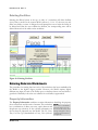
1
Standardized Reclamation
Cost Model
User Manual
Public Domain Version
Standardized Reclamation
Cost Model
User Manual
Version 1.12 Public Domain Version
Disclaimer:
Use of the Standardized Reclamation Cost Estimator (the Model) is conditioned
upon your acceptance of the terms and conditions set forth in the Model, as they
may be amended from time to time. By opening and using the Model, the use
accepts these terms and conditions without limitation.
Prepared with the generous support of:
and
September 2009
Table of Contents
1 Introduction ..................................................... 1-1
Purpose ........................................................................................ 1-1
Background ................................................................................. 1-2
Model Validation .......................................................................... 1-2
The Future .................................................................................... 1-3
Things to Remember ................................................................... 1-3
Conventions Used In This Manual ............................................. 1-5
2 How it Works ................................................... 2-1
Volume Calculations ................................................................... 2-1
Surface Area Calculations .......................................................... 2-3
Equipment Productivities ........................................................... 2-4
Miscellaneous Productivity Calculations .................................. 2-7
Dozing Distance Calculations .................................................... 2-8
Cycle Times for Material Hauling Fleets .................................... 2-9
Fleet Productivities ..................................................................... 2-9
Solution Management ................................................................. 2-9
3 Gathering Your Data ....................................... 3-1
Cost Data...................................................................................... 3-1
Project Data ................................................................................. 3-3
4 Setting Up Cost Data Files.............................. 4-1
Source Data ................................................................................. 4-2
Basis/Region Table ..................................................................... 4-2
Equipment Costs ......................................................................... 4-3
Labor Rates.................................................................................. 4-4
Reclamation Material Costs........................................................ 4-5
Miscellaneous Unit Costs ........................................................... 4-5
Indirect Costs .............................................................................. 4-6
5 Entering Data into the Model .......................... 5-1
Basic Data Entry .......................................................................... 5-1
Basic Model Commands ............................................................. 5-2
Adding Facilities ................................................................................. 5-3
i
Version 1.12
T A B L E
O F
C O N T E N T S
Clearing User Data from a Worksheet ...............................................5-3
Deleting Facilities ...............................................................................5-4
Entering Data into Worksheets .................................................. 5-4
Property Information ...........................................................................5-4
Exploration Data .................................................................................5-5
Exploration Drillholes....................................................................5-6
Exploration Trenches ...................................................................5-6
Exploration Roads and Pads ........................................................5-6
Mine Facilities ....................................................................................5-8
Waste Rock Dumps and Heap Leach Pads .................................5-8
Tailings Impoundments ..............................................................5-12
Roads .........................................................................................5-13
Pits .............................................................................................5-14
Underground Openings ..............................................................5-15
Haul Material ..............................................................................5-15
Foundations and Buildings .........................................................5-16
Other Demolition and Equipment Removal ................................5-18
Diversion Ditches and Sediment Ponds .....................................5-18
Process Ponds ...........................................................................5-19
Landfills ......................................................................................5-20
Yards, Etc. ..................................................................................5-20
Waste Disposal ..........................................................................5-20
Well Abandonment .....................................................................5-21
Misc. Costs .................................................................................5-22
Monitoring...................................................................................5-22
Construction Management .........................................................5-25
Solution (Water) Management ...................................................5-27
Closure Planning ........................................................................5-28
Other User ..................................................................................5-28
General and Administration ........................................................5-28
Human Resources......................................................................5-28
User Sheets................................................................................5-29
6 How do I . . . ?.................................................. 6-1
… Import Cost Data in to the Model ........................................... 6-1
… Import Data from a Previous Model File................................ 6-2
… Calculate Closure of Multi-Lift Dumps .................................. 6-3
Multi-lift (additive) ...............................................................................6-3
Multi-lift (separate) .............................................................................6-4
Version 1.12
ii
T A B L E
O F
C O N T E N T S
… Create a Cover with More than Two Layers .......................... 6-4
… Incorporate Cyanide Code Compliance ................................ 6-6
… Calculate Pit Backfilling ......................................................... 6-6
… Add Mobilization and Demobilization Costs ........................ 6-6
… Add Site Specific Costs for Materials ................................... 6-7
… Get the StdRecCost Menu Back ............................................ 6-8
… Get Additional Help............................................................... 6-10
… Report a Model Bug .............................................................. 6-11
… Make a Suggestion for Future Versions ............................. 6-12
Tables
Table 1 - Dozer Productivity vs. Grading Distance ............................................... 2-5
Figures
Figure 1 - Furstrum of a Pyramid ............................................................................ 2-1
Figure 2 - Regrading Volume (a) Uphill and (b) Downhill ..................................... 2-2
Figure 3 - Slope Regrading Cross-Sectional Area Calculation ........................... 2-3
Figure 4 - Surface Area Calculations...................................................................... 2-4
Figure 5 - Dozer Productivity vs. Distance ............................................................ 2-6
Figure 6 - Use of Means Crews and Productivities ............................................... 2-8
Figure 7 - Dozing Distance Calculation .................................................................. 2-8
Figure 8 - Indirect Costs .......................................................................................... 4-6
Figure 9 - Adding Facilities ..................................................................................... 5-3
Figure 10 - Deleting Facilities.................................................................................. 5-4
Figure 11 - Property Information Worksheet (non-Nevada version shown)....... 5-5
Figure 12 - Road Recontouring Calculation .......................................................... 5-7
Figure 13 - Exploration Road Inputs....................................................................... 5-7
Figure 14 - Exploration Road Zones ....................................................................... 5-8
Figure 15 - Waste Rock Dump or Heap Slope Inputs ........................................... 5-9
Figure 16 - Regrading Volume Inputs..................................................................... 5-9
Figure 17 - Example Waste Rock Dump ............................................................... 5-11
Figure 18 - User Input for Example Waste Rock Dump ...................................... 5-11
Figure 19 - Tailings Impoundments ...................................................................... 5-12
Figure 20 - Tailings Embankment Parameters .................................................... 5-13
Figure 21 - Buildings and Foundations ................................................................ 5-17
Figure 22 - Diversion Ditches & Sediment Ponds ............................................... 5-19
Figure 23 - Process Pond User Input ................................................................... 5-20
Figure 24 - Well Seal Thicknesses ........................................................................ 5-22
Figure 25 - Reclamation Maintenance .................................................................. 5-23
Figure 26 - Reclamation Monitoring ..................................................................... 5-24
Figure 27 – Rock & Water Monitoring .................................................................. 5-25
iii
Version 1.12
T A B L E
O F
C O N T E N T S
Figure 28 – Construction Management ................................................................ 5-26
Figure 29 - Road Maintenance............................................................................... 5-26
Figure 34 - Import Cost Data Menu ......................................................................... 6-1
Figure 35 - Import User Data Menu ......................................................................... 6-2
Figure 36 - Multi-Lift Slope Inputs (additive) ......................................................... 6-3
Figure 37 - Multi-Lift Slope Inputs - Separate ........................................................ 6-4
Figure 38 - Waste Rock Dumps – Cover and Growth Media Costs ..................... 6-5
Figure 39 - Waste Rock Dumps - Scarifying/Revegetation Costs ....................... 6-5
Figure 40 - Example of User Cost Data .................................................................. 6-8
Figure 41 - User Tools (Version 1.2 or later) .......................................................... 6-8
Figure 42 - Macro Menu ........................................................................................... 6-9
Figure 43 - Macro Dialog Box .................................................................................. 6-9
Figure 44 - NVBond.org Web Site ......................................................................... 6-10
Figure 45 - Frequently Asked Questions (FAQ) .................................................. 6-10
Figure 46 - Known Issues Page............................................................................. 6-11
Figure 47 - NVBond.org Bug Report ..................................................................... 6-11
Figure 48 - NVBond.org Suggestion Page ........................................................... 6-12
Appendices
Appendix A – Technical Reference
Appendix B – Tutorial Exercises
Version 1.12
iv
1
Chapter
1 Introduction
The Model was developed to provide a useful reclamation and
closure cost estimating tool that standardizes user input
requirements, productivity calculations, volume and area
calculations in a consistent format while allowing enough flexibility
to incorporate site-specific conditions.
T
his chapter could be subtitled “Why did we do it?”. The answer to that
question is fairly simple: we did it to provide a tool to facilitate accuracy,
completeness and consistency in the calculation of costs for mine site
reclamation. The process to achieve that goal wasn’t so simple.
The Standardized Reclamation Cost Estimator (SRCE) model (the
Model) was originally developed with guidance developed during
the implementation of the Nevada Standardized Unit Cost (NSUC)
Project, a cooperative effort between the Nevada Division of
Environmental Protection, Bureau of Mining Regulation and
Reclamation (NDEP), the U.S. Department of Interior, Bureau of
Land Management (BLM) and the Nevada Mining Association (NvMA) to facilitate
accuracy, completeness and consistency in the calculation of costs for mine sites
reclamation.
Purpose
The purpose of the Model is to provide a tool to assist mining professionals improve
the consistency and accuracy of reclamation and closure cost estimates. Although the
Model was developed to provide standardized approaches to reclamation and closure
cost calculations, the need to account for diverse approaches to mine closure, and
differences between mining operations and regulatory requirements required that the
Model also provide a reasonable amount of flexibility. To that end, the Model requires
fairly limited user input to perform the cost calculations yet allows the user to combine
or subdivide the input data in a number of different ways to account for site specific
conditions and reclamation methods.
1-1
Version 1.12
I N T R O D U C T I O N
Background
In late 2002 a group of mining professionals representing the
mining industry, and state and federal regulatory agencies in the
State of Nevada (USA) met to discuss the concept of developing
a standardized cost estimating approach to improve the
consistency of closure cost estimates for surety bonding
purposes. This initial meeting led to the formation of the
NSUCP, which ultimately provided guidance used in developing the Model.
The Model was originally developed primarily for use in the State of Nevada, and as
such the original version tended to focus on the types of facilities and approaches
commonly used for mine reclamation and closure in Nevada. The format of the Data
Files was also the result of the origins of the Model. Because the initial focus of the
Model was to calculate reclamation and closure bond costs, the Data Files needed to be
formatted to incorporate certain data and standards required by US and Nevada
regulations.
However, even during the initial development, a number of the NSUC Project
participants saw the potential to use the Model for other purposes. Among those
possible uses were mine closure cost planning, due diligence, feasibility studies, budget
tracking and financial reporting requirements. As a result the initial versions and
subsequent derivative versions of the Model have been, and are being developed to
expand the capabilities to include these other uses. Nonetheless, a Nevada-specific
version of the Model does, and may always exist to meet the needs of the industry and
regulators in Nevada.
The original version (v. 1.0) of the Model was released for a six-month trial period in
March 2006 after about three years of development and beta testing. A second version
(v. 1.1) was an update of the original based on feedback from the trial period, and the
first metric-capable version was released in mid-2009.
The NSUC Project was implemented largely on a voluntary basis with initial funding
provided the NvMA for the development of the original guidelines. The Model
continues to be developed and supported primarily on a voluntary basis, and several
versions of the Model are publicly available free of charge. For more information on
the NSUC Project please see the About SRCE page at the www.nvbond.org website.
Model Validation
Initially, the Model was validated in the State of Nevada (U.S.A.) through an extensive
alpha and beta testing process that lasted approximately 18 months. This beta testing
process was conducted by representatives from the mining industry, and federal and
state regulatory agencies. Beta testers validated the accuracy of the majority of the
Model calculations using manual methods, civil CAD software, GIS and other cost
Version 1.12
1-2
I N T R O D U C T I O N
estimating tools. The volumetric calculations were found to be very accurate in
comparison to other methods, providing the project data was properly entered.
Productivity calculations were largely derived from published sources such as the
Caterpillar® Performance Handbook (ed. 35)1 and were compared against actual field
conditions. Although productivity calculations for specific tasks can be highly variable,
the beta testing period indicated that the overall time required to perform most tasks
was within the range of data from actual projects, or slightly conservative.
During the six-month trial period following the beta testing process, additional
modifications were implemented as well as comparisons with actual field data from
ongoing reclamation and closure projects. Version 1.1 (later revised to version 1.1.2),
released in October 2006 incorporated a number of changes and enhancements based
on input from the trial period, including new productivity formulae for exploration drill
road reclamation.
During the period July 2006 through August 2009, a number of enhancements and
additions were made to the international (metric) version of the model. These changes
were based on feedback provided by a number of users on six continents. Although
not every change or new feature requested by the users was incorporated into the
current version of the model, many enhancements were made.
The Future
The author of the Model and many of the active supporters of the
NSUC Project always envisioned that it would evolve through use,
change, improvement and expansion. Several revisions of the Model
have already been released since the original trial period ended,
including a version that is capable of using either imperial or metric
units. Other improvements and additions have already been added to
the original version, some of which have been incorporated into the Nevada version of
the Model. Others have yet to undergo the testing and approval process required for
inclusion in the Nevada version. Many additional capabilities have already been added
to the international version of the model, some of which may be added to the Nevada
version at some time in the future.
Things to Remember
In order for any model to provide useful results, the user must
understand not only the Model but also the system that the Model is
intended to simulate. The best results will be obtained from the
Model when used by a qualified mine closure professional with an
understanding of closure planning, construction techniques used for
mine reclamation and closure, and standard cost estimating practices.
However, by creating a tool that can be used by less experienced people we recognize
that it will be used by people with a broad range of skills and experience. With that in
1-3
Version 1.12
I N T R O D U C T I O N
mind, we offer the following cautions and caveats that one should consider before
embarking on the process.
• The Model results are only an estimate. It is always tempting to
believe the numbers that come out of a computer model without
question. However, for a number of reasons, it is important to
remember that the Model results are only an estimate. A number of
factors that will affect the accuracy of the estimate, but it is nonetheless
only an estimate. Issues such as numerical rounding, the reliance of the
calculations on other estimates for components such as productivities
and volume calculations, and the accuracy of the input data will all
affect the level of accuracy. It is important to understand both the
limitations of the estimate and the areas of uncertainty in the data used
and the calculation methods.
• Know the intended use of the estimate. What you plan to do with
the estimate will dictate the amount of effort required to gather the
information needed to provide the accuracy required from that data.
• There is more than one way to prepare a cost estimate. Although
the Model provides a fairly simple method for estimating reclamation
and closure costs, it is not the only way to do so. There are other tools
and approaches to preparing closure cost estimates and some of these
may be more suitable for a particular use, or may be appropriate for
use in combination with the Model.
• Results from Model are only as good as the
plan and data used as a basis for the cost
estimate. There is nothing in the Model that can
make up for an incomplete reclamation and
closure plan. It will not add things you left out. It
will not correct your input data. That being said,
if used properly, it can assist the user in finding gaps in their closure
planning process and in certain circumstances may highlight data
errors. It can also be used in evaluating the relative costs of different
reclamation and closure approaches to assist in the planning process.
• The Model is only a tool. It cannot do your work for you and will
only provide results based on your input. Don’t blame the tool if you
don’t like the results. A poor workman blames his tools.
• There is no such thing as perfect software. Although the process
of beta testing, the trial period and subsequent use by mine closure
specialists has resulted in rigorous testing of typical uses for the Model,
Version 1.12
1-4
I N T R O D U C T I O N
it also identified a number of needed changes including bug fixes.
Testing for any model only includes scenarios contemplated by the
testing team, because the Model was developed to be as flexible as
possible, there are undoubtedly many possible scenarios that have yet
to be tested. As users attempt to use the Model in ways unforeseen by
the testing team, new issues are likely to arise. On the other hand, as
the Model continues to be used by different people on different mine
sites it will improve, provided the users continue to provide feed back.
The best way to do that is to submit suggestions and bug reports
through the www.nvbond.org web site.
Conventions Used In This Manual
In order to make this manual
readable and useful as a
functional
user
guide,
standardized text formatting
conventions have been used.
These formats are intended to
highlight different components of
the Model and model input
requirements.
TEXT CONVENTIONS
A1 x 1.2 = A2
Property Information
Regrade Volume
Delete
Formula or algorithm
Module or Table Name
Cell Name
Button Name
Icons have also been used to highlight important information included in the manual.
Notes and tips are shown in grey boxes with the icons along the other edge of the
page. Special icons are also used
ICON KEY
to denote capabilities only
available in certain versions of the
Important Note
Model.
Generally
these
Tip
differences are cumulative (i.e.
what is available in the Nevada
Available in Nevada version only
version is available in the Metric
version, but some options
Available in Metric/Imperial version only
included in the metric version are
not available in the Nevada
SRK/Barrick version only
version).
1
Caterpillar® Performance Handbook, Edition 35, a CAT® publication by Caterpillar
Inc., Peoria, Illinois, U.S.A., October 2004
1-5
Version 1.12
2
Chapter
2 How it Works
The Model was developed to utilize a first-principles approach to
reclamation cost estimating, to the best degree possible. A basic
understanding of the principles employed to calculate areas,
volumes, productivities and time should help the user effectively use
the Model.
T
he methods of calculation used in the Model are based on first-principle
approaches for volume and distance calculations, and productivity estimation.
In some instances, new approaches and software code were developed to
implement and combine these standard methods into a single model that
allows both consistency and flexibility.
Volume Calculations
Where possible, the Model uses the simplest methods for volumetric estimation. For
example, pond volumes are calculated based on the formula for the furstrum of a
regular pyramid to determine pond
volumes for backfilling calculations
b
a
and surface areas for liner
s
installation (see Figure 1). Where
simple calculations are inadequate to h
fulfill the goals of simplicity of use
and flexibility for site specific
c
d
conditions, the Model uses
combinations of basic formulae or
Visual Basic (VBA) code to estimate
Area and Volume of the Frustrum of a Pyramid
volumes.
s
Surface Area = ab + cd + (a+b+c+d) x
Volume =
h (ab + cd + √abcd )
3
2
Figure 1 - Furstrum of a Pyramid
2-1
Version 1.12
H O W
I T
W O R K S
In the case of the calculation of slope regrading volumes creation of a new VBA code
was necessitated because the Model needed to calculate volumes for situations where
the fill material would be pushed downhill at the toe of the dump (see Figure 2 (a))
and situations where the material would be pushed into an opposing hillside (see
Figure 2 (b)). In both instances, the Model uses a VBA routine to calculate a series of
cross-sectional cut and fill areas designated by A1 and A2, respectively, using the
parameters
shown
on
A1
(a)
Ungraded
(original dump)
slope
A2
Underlying
(original ground
slope)
A1
Underlying
(original ground
slope)
A2
(b)
Ungraded
(original dump)
slope
ST (Top Slope)
b2
γ2
a2
α2
Cut
c2
β2
h (Lift Height)
Cut-to-Fill pivot point
optimized
β1
c1
a1
SU (Ungraded slope)
Fill
γ1
SO (Original slope)
α1
SF (Final slope)
b1
Figure 3 until A1 = A2. By using this VBA routine the Model determines the exact
dimensions necessary for a balanced cut-to-fill.
Figure 2 - Regrading Volume (a) Uphill and (b) Downhill
Version 1.12
2-2
H O W
I T
W O R K S
ST (Top Slope)
b2
γ2
a2
α2
Cut
c2
β2
h (Lift Height)
Cut-to-Fill pivot point
optimized
β1
c1
a1
SU (Ungraded slope)
Fill
γ1
SO (Original slope)
α1
SF (Final slope)
b1
Figure 3 - Slope Regrading Cross-Sectional Area Calculation
Once the cross-sectional cut and fill areas are determined, the Model estimates the cutto-fill volume by the formula A1 x mid-bench length. The mid bench length is a user
input representing the distance of a line along the contour of the slope approximately
½ the way up the slope. This slope regrading volume estimation method is used in the
Waste Rock Dumps, Heap Leach and Tailing Impoundment modules.
The Model also uses a similar method to estimate cut-to-fill volumes for road
recontouring, but recognizes that the fill volume requiring placement back in the cut
will have expanded during excavation. To account for this the Model applies a 20%
swell factor to the cut volume by the formula: A1 x 1.2 = A2.
Surface Area Calculations
All calculations in the Model used to determine the quantity of seeded area and the
volume of cover material are based on true surface areas rather than footprint areas.
The surface area on non-planar facilities (e.g. waste rock dumps, heap leach pads, etc.)
is estimated from the results of the cut-to-fill volume VBA routines as follows:
2-3
Version 1.12
H O W
I T
W O R K S
Final Slope Length = Final Slope of Fill (c1) + Final Slope of Cut (c2) (see
ST (Top Slope)
b2
γ2
a2
α2
Cut
c2
β2
h (Lift Height)
Cut-to-Fill pivot point
optimized
β1
c1
a1
SU (Ungraded slope)
Fill
γ1
SO (Original slope)
α1
SF (Final slope)
b1
Figure 3)
Final Disturbance Area = user input (footprint of resloped facility)
Final Slope Surface Area = Mid-Bench Length x Final Slope Length
Final Slope Footprint Area = Horizontal Distance between Final Crest and Final Toe x
Mid-Bench Length
Final Flat Area = Total Final Disturbance Area – Final Slope Footprint Area
Final Surface Area = Final Slope Area + Final Flat (Footprint) Area (see Figure 4)
Where facilities are assumed to be flat (e.g. yards, tailings impoundment surfaces,
landfill surfaces, building foundations, the Model assumes that surface area =
footprint area.
Final Dump Flat Footprint Area
Final Dump Slope Footprint Area
Original Dump Slope
Footprint Area
Original Dump Flat Footprint Area
Final Surface Area
Figure 4 - Surface Area Calculations
Equipment Productivities
The Model uses several different sources and methods for calculating equipment
productivities. The primary source is the Caterpillar® Performance Handbook1 (CAT
Version 1.12
2-4
H O W
I T
W O R K S
Handbook). Other sources include the Means Heavy Construction Cost Data 20062,
equipment and material suppliers, and local contractors. In some instances, such as
exploration roads, and drillhole and well abandonment, productivity data was collated
from actual work performed in the field and used to adjust the calculated numbers to
reflect actual data.
Where the CAT® Handbook was used, several different approaches were used. If
productivity curves were include in the Handbook, tables in the Model (see Table 1)
were created based on those curves and then converted back to curves using the
graphing functions in MS Excel. From those graphs, a trendline was fitted to each
curve using built-in Excel functions (see Figure 5). The formula for each curve is then
used in the calculation of equipment productivity for each situation where that
equipment is specified by the user. For example, if a D9R dozer is used to push
material 280 feet the formula used to calculate the productivity will be:
Productivity = 89889 x 280-0.9425
Table 1 - Dozer Productivity vs. Grading Distance
Dozer Productivity vs. Grading Distance
Production (LCY/hr)
Average
Dozing
Distance
(feet)
D11R
D10R
D9R
D8R
D7R
D6R
50
100
200
300
400
500
600
4800
2800
1500
1000
750
600
500
2800
1700
950
625
500
410
350
2000
1250
700
450
300
250
200
1400
850
475
275
175
125
100
1000
700
375
250
520
210
150
Source: Caterpillar Performance Handbook Edition 35
p
dozer productivity = k x Dozing Distance
(see graph)
k=
185082
p=
-0.919
2-5
81639
-0.8502
89889
-0.9425
115087
-1.0809
22719
-0.7796
101029
-1.1506
Version 1.12
H O W
I T
W O R K S
Dozer Productivity (Semi-U Blade)
3000
2500
y = 185082x -0.919
2000
D11R
LCY/hr
y = 81639x -0.8502
D10R
D9R
1500
D8R
y = 89889x
D7R
-0.9425
1000
y = 115087x -1.0809
500
y = 22719x -0.7796
0
0
100
200
300
400
500
600
700
Dozing Distance (feet)
Source: Caterpillar Performance Handbook Edition 34
Figure 5 - Dozer Productivity vs. Distance
Other examples of equipment with productivity curves include the uphill travel times
for scrapers and trucks. For equipment that utilizes grade retarding curves to determine
downhill travel speeds (i.e. scrapers and trucks), speed tables were prepared from the
curves. These downhill speed curves were then used in conjunction with the uphill
travel time curves to produce cycle times from the user input data.
Productivities for equipment such as loaders and excavators were calculated from cycle
time tables and graphs in the CAT® Handbook assuming average bucket capacity and
bucket sizes matched to the equipment and task. Average capacity was estimated by the
formula:
Average Capacity = Struck Capacity + ½ (Heaped Capacity – Struck Capacity)
As appropriate, correction factors for equipment are added to the productivity
calculations for each facility. Some of the correction factors included in the Model for
some or all of the equipment include Job Efficiency, Slope Grading, Rolling Resistance,
Operator Efficiency, Density Correction, Material Type, Visibility and Slot Dozing.
These correction factors are based on information provided in the CAT® Handbook
and applied based on industry standards or site-specific conditions. Job Efficiency and
Version 1.12
2-6
H O W
I T
W O R K S
Operator Efficiency correction factors can be adjusted by the user in the International
version at the top of the Productivity sheet in the Model.
The Model combines the information input by the user for each facility with the
productivity formulae, tables and correction factors created from published data and
industry data to calculate the individual productivity As an example, if a user adds a 30
meter high dump facility that will require grading from angle-of-repose to a 3H:1V
slope, the Model will follow the following steps to estimate the cost to regrade the
slope:
1) Calculate volume of cut material to push
2) Calculate the push distance
3) Apply the Dozing Distance vs. Productivity Curve Formulae to estimate
uncorrected productivity.
4) Apply correction factors based on user input and standard values to calculation
corrected dozer productivity
5) Divide dozing volume by corrected productivity to calculate work hours
6) Multiply equipment and labor rates to work hours to calculate cost.
Miscellaneous Productivity Calculations
Where published equipment data is not available to calculate productivities, other
sources including published cost databases, contractor data and field data were used to
determine productivity information for other types of equipments and crews.
Bore plugging and well abandonment productivities are based on data from
approximately 65 exploration drillholes and 30 monitor and production wells. These
data, taken from daily drillers logs were compiled to determine the production rates for
casing removal, casing perforation and grouting.
Productivities for demolition and other miscellaneous tasks are estimated from
information contained in and used by permission from Means Heavy Construction
Cost Data 20063 (Means). As an example, wall demolition productivities (and crews)
from Means are combined with the equipment and labor cost data imported into the
Model to calculate a unit cost for each wall type (see Figure 6).
2-7
Version 1.12
H O W
I T
W O R K S
Means Number
Unit
Crew
Daily
Output
02220-130-2000
02220-130-2040
02220-130-2080
02220-130-2100
02220-130-2400
02220-130-2420
02220-130-2440
02220-130-2500
S.F
S.F
S.F
S.F
S.F
S.F
S.F
S.F
1 Clab
1 Clab
1 Clab
1 Clab
B-9
B-9
B-9
B-9
180
170
150
150
160
140
120
100
Materials
Labor Equipment
Premium
Total
Notes
20%
20%
20%
20%
10%
10%
10%
10%
$1.84
$1.94
$2.21
$2.21
$8.62
$9.86
$11.50
$13.79
assumes
assumes
assumes
assumes
assumes
assumes
assumes
assumes
Wall Demolition
Block 4" thick
Block 6" thick
Block 8" thick
Block 12" thick
Conc 6" thick
Conc 8" thick
Conc 10" thick
Conc 12" thick
$1.53
$1.62
$1.84
$1.84
$6.90
$7.89
$9.20
$11.04
$0.94
$1.07
$1.25
$1.50
vertical reinforcing rods included (20%
vertical reinforcing rods included (20%
vertical reinforcing rods included (20%
vertical reinforcing rods included (20%
average reinforcing (10% premium)
average reinforcing (10% premium)
average reinforcing (10% premium)
average reinforcing (10% premium)
premium)
premium)
premium)
premium)
EQUIPMENT FLEETS
EQUIPMENT
UNIT COST
(Hourly)
ACTIVITY AND FLEET
LABOR
UNIT COST
(Hourly)
TOTAL
COST
(Hourly)
B-9 - Concrete Wall Demolition
General Laborer
General Laborer
General Laborer
General Laborer
Foreman
Air Compressor + tools
$0.00
$0.00
$0.00
$0.00
$13.03
$15.46
$28.49
Totals
$35.73
$35.73
$35.73
$35.73
$52.01
$0.00
$194.93
$35.73
$35.73
$35.73
$35.73
$65.04
$15.46
$223.42
Figure 6 - Use of Means Crews and Productivities
Dozing Distance Calculations
The Model uses a simplified estimating technique to determine the effect of dozing
distance on the dozer productivity. On short dumps or short lifts on multi-lift dumps
the dozing distance calculation method used is likely to result in a slightly conservative
productivity because it assumes that the average distance is assumed to be 2/3 of the
calculated final slope length (see Figure 7). However, on taller slopes, the dozer is
likely to make numerous shorter cuts at an angle sub parallel to the final slope angle.
This would result in some double-handling of material, but the productivity of each
dozer push would be much higher than if the 2/3 of final slope length were applied.
The exact effect of this approximation method will depend on the specific dimensions
of the slope to be regraded. In some instances, the Model is likely to overestimate the
total time required to complete the work. In others, it may slightly underestimate the
work time. However, overall it is likely to provide a reasonable approximation of the
time required. Comparisons with field data may result in future modifications to this
approach.
Top Slope
Cut
Dozing distance =
2
(c1 + c 2 )
3
Dozing
distance
c2
Cut-to-Fill pivot point
optimized
Original slope
Ungraded slope
c1
Fill
Final slope
Figure 7 - Dozing Distance Calculation
Version 1.12
2-8
H O W
I T
W O R K S
Cycle Times for Material Hauling Fleets
Cycle times for material hauling fleets are estimated by combining the uphill travel time
curves and the downhill travel speed tables with the project data provided by the user.
Loaded vehicle weights for use with the travel speed tables are based on standard
materials included in the CAT® Handbook. The Rolling Resistance factor used
assumes a regularly maintained dirt road will be used. The equipment cycle time is then
calculated as follows:
Cycle Time = Maneuver to Load Time + Loading time + Loaded Haul + Dumping
Time + Empty Haul Time
The loading time is based on the cycle time for the loading equipment (e.g. front end
loader). The loaded and empty haul times are based on either the travel time curves or
travel speed tables depending on whether the equipment is performing an uphill or
downhill loaded haul.
Fleet Productivities
Fleet productivities are the compilation of the individual equipment productivity of all
of the equipment in the fleet. The fleets are assumed to be limited by the cycle time of
the loading equipment (i.e. loader limited) and the number of hauling units is
determined by the loading cycle. This means that a truck fleet size is determined cycle
time of the loader and the loader is assumed to never be idle. For example, if the time
required by a truck to make a round trip is slightly more than twice the loader cycle
time, then the Model will assume that three trucks are required with two traveling and
one being loaded at all times. The overall fleet productivity and work hours are
therefore based on the loader productivity. The total cost for hauling is then calculated
by multiplying labor and equipment rates by the number pieces of equipment in the
fleet including the loader, trucks and spreading dozer.
Dozer loaded scraper fleets are assumed to be dozer limited, and the cycle times and
fleet sizes are determined on that basis.
Solution Management
The solution pumping, forced evaporation and decontamination tables included in the
Solution Management module include cost calculations for pumping water from one
location to another using Manning’s Equation and other standard hydraulic formulae.
This module uses these formulae to estimate the energy (kW) required to pump
solution a defined distance with a hydraulic head through a pipe of a known diameter
and material. Once the energy required is known, the cost of pumping that water can
be calculated by applying the total pumping time and unit cost of the energy.
The forced evaporation option also includes an option for the user to define a required
pressure at the end of the pipe.
2-9
Version 1.12
H O W
1
I T
W O R K S
Ibid.
2
Means Heavy Construction Cost Data 2006. Reed Construction Data, RSMeans,
Kingston, MA., Copyright © 2006
3
Ibid.
Version 1.12
2-10
3
Chapter
3 Gathering Your Data
The Model was designed to allow a variety of input methods while
ensuring that the simplest methods would still produce accurate
results.
T
he data required to perform a reclamation cost estimate using the Model is
determined by two primary factors; the minimum data required by the Model
to calculate costs, and the intended purpose of the cost estimate. The Model
requirements dictate the minimum data necessary to produce a usable cost
estimate. The intended purpose will define the level of detail of the input data.
The Model requires the user to provide two types of data; cost data and project data.
Cost data include the equipment, labor and material rates required to perform the
reclamation and closure activities. Project data are the dimensions, methods, and design
criteria used to define the closure plan for the facilities.
Cost Data
The cost data required as input to the Model can be obtained from
a number of sources and comprise the underlying rate assumptions
used in the cost estimation process. The particular cost data
required for any estimate will be dependent on the available
information and the purpose for which the cost estimate is being
prepared. Reclamation cost estimates for the purpose of providing
a surety estimate for regulatory purposes typically require the use of governmentapproved rates. Financial reporting requirements usually dictate the use of third-party
contractor rates as a base for equipment, labor and material rates. If the purpose of the
cost estimate is for mine planning costs, then actual mine costs, or costs from an
analogue mine could provide the most appropriate rate basis.
Important Note
Some regulatory jurisdictions, such as the State of Nevada, require the use of
approved cost data. Links to these data files can be found at www.nvbond.org.
3-1
Version 1.12
G A T H E R I N G
Y O U R
D A T A
Regardless of the purpose of the cost estimate, experience shows that most cost
estimates require the use of data from a number of sources, rather than a single one.
Some of the most common sources of rate data include:
• Government Publications – Many governments publish cost data as
part of government contracting procedures. Often these comprise the
data required for reclamation and closure cost estimates used for the
purpose of determining the amount of regulatory surety required for a
project.
In some jurisdictions, government funded institutes also compile cost
data from government contracts and the private sector. These
databases can be substantial and have the advantage of tracking costs
over time, allowing the analysis of trends. Commonly, the final output
from these institutional cost databases is a unit cost for each particular
activity. Because the Model does not generally use activity unit costs,
much of the data in these databases may not be usable as input to the
Model. However, in many instances, these data used to derive these
costs including equipment and labor rates, material costs, fleets and
productivities are also recorded or can be derived from the published
information.
• Published Cost Databases – There are a number of commercial cost
databases compiled from public and private sources available for
purchase. These databases may provide rate data for labor, equipment
and materials or unit cost data by activity. If unit costs by activity are
provided, the resources (labor, equipment and materials) required for
each activity are often provided along with an estimate of the
productivity of the assigned resources.
The resources (crews) and crew productivities from one of these
databases (Means Heavy Construction Cost Estimating Guide, ©2006)
was used in the Model for some of the miscellaneous unit costs. The
Model then combines the crews and productivities with rate data to
calculate a Model unit cost for each activity.
• Third-Party Contractors – One of the most accurate sources of cost
data is a contractor’s estimate. Most financial reporting standards
require the use of third-party costs. Although contractor’s estimates
rarely include detailed equipment and labor rates, they may be willing
to provide those data upon request. However, when supplying rate
data, the contractor may intentionally provide an inflated rate to
protect a competitive advantage.
Version 1.12
3-2
G A T H E R I N G
Y O U R
D A T A
Equipment costs provided by contractors may be inclusive of
preventative maintenance, consumables and wear costs. If so, this
should be noted and the Data File imported into the Model modified
to reflect this (see Chapter 4 – Setting Up Cost Data Files).
However, the hourly rate for equipment should not include the cost of
fuel as this is automatically calculated by the Model based on the fuel
cost and published data on fuel consumption for different types of
equipment.
When requesting labor rate data from a contractor, the basis for that
data should be defined (e.g. government vs. union vs. non-union rates)
and upon receiving contractor data, the user should confirm whether
the labor rates provided include all indirect costs including fringe
benefits, tax withholding, retirement funding, insurance and
contractor’s profit. If the indirect costs are not available from the
contractor, they may be available through government published data.
• Suppliers – Material suppliers and vendors are generally the best
source of data on reclamation and closure materials. For materials with
highly variable rates such as fuel, electricity and seeds, use of data
averaged over a period of time such as a year or two may provide a
more defensible rate. For costs with demonstrated trends, the addition
of an inflation/deflation factor may be appropriate if the term of the
cost estimate is long enough to be affected by those trends.
• Mine Data – For cost estimates intended for planning and budgeting
purposes, the best source of data is generally the mine for which the
cost estimate is being calculated, or a similar mine in the general
region. Where these data are available, care must be taken to ensure
that the reported data includes all indirect costs applicable to the
intended purpose of the cost estimate.
Important Note
The data loaded into the Model must not include fuel cost. This is calculated
in the Model from published fuel consumption data and the fuel cost in the Cost Data
File imported into the Model.
Project Data
The Model was designed to allow a broad range of methods for
gathering the project data required to estimate a reclamation and
closure cost. However, the accuracy of the maps and project data
available will have a direct impact on the accuracy of any cost estimate
prepared using the Model. At a minimum, accurate topographic maps
3-3
Version 1.12
G A T H E R I N G
Y O U R
D A T A
showing all project facilities at the time of closure and after reclamation is complete are
critical to provide user input data required by Model.
• Maps - At the most basic level, most of the required project data can
be gathered using a topographic map and an engineer’s scale. Facility
heights can be obtained from the contour elevations. Most distances
and areas can be measured approximately with an engineer’s scale, and
slopes can be calculated from scale measurements and contour
elevations printed on the map. A planimeter can be use to improve the
accuracy of the distance and area measurements.
• Electronic CAD Drawings – Obtaining measurements from
drawings created in a CAD package such as AutoCAD is a very
effective method of collecting project data required for the different
modules of the Model. Two dimensional measurements such as
lengths and areas of project facilities can be obtained directly from
CAD drawings. Three dimensional parameters such as heights, slopes
and volumes can often be directly obtained from CAD drawings or, if
necessary, calculated from two dimensional measurements.
• Mine Planning Software – Like CAD, mine planning software can
provide all of the physical dimensions needed by the Model to
calculate the cost estimate. These software packages can also estimate
volumes, and often can calculate cycle times, volumes and reshaped
slope dimensions, which can be used to check the Model calculations.
When using the Model to schedule costs, a mine planning package can
also provide useful information on how it will take a given fleet to
perform an activity and also assist in the sequencing of the reclamation
and closure activities.
• GIS – Geographical Information Systems software combine the use
of vector and image data into a geographical database. GIS can
combine the functionality of data collection from maps, digital design
drawings and survey data. Two dimensional measurements such as
lengths and areas can be obtained directly from the tables. Three
dimensional data can also be incorporated into the attribute tables
using built-in formula calculations. Utilizing aerial photography and
survey data travel distances and slopes can also be calculated. GIS also
provides the ability to document measurements made into tables as a
visual auditing trail.
• Air Photos – Current aerial photos over a site can provide the basis of
the physical dimensions needed by the Model to calculate the cost
estimate. Aerial Photos once registered in geographical space allow you
Version 1.12
3-4
G A T H E R I N G
Y O U R
D A T A
to visually see the footprint of features and can be combined into a
GIS database, Vector tables can be created from visually tracing
features and then geometrical information can be obtained directly
from the GIS.
• Internet Tools - other tools such as Google Earth are available via the
internet. Google Earth provides aerial photography on a geographical
platform where you can draw, measure and obtain physical dimensions
for the Model using the tools provided. This method can be extremely
helpful in areas where site data is not available and there is current
public access to aerial photography at a usable resolution.
3-5
Version 1.12
4
Chapter
4 Setting Up Cost Data Files
The cost data used by the Model must first be loaded into a
specially formatted cost data file.
T
here are two types of data files that can be used to load cost data into the
Model; Standardized Data Files and User Data Files. Standardized Data Files
contain data that can only be modified with a password. The data in User Data
Files can be changed by anyone.
• Standardized Data Files may be used by regulatory jurisdictions or
corporate accounting departments to ensure that the Model uses a
particular set of data dictated by regulatory or corporate standards.
• User Data Files allow the user to input their own data.
Important Note
Some regulatory jurisdictions, such as the State of Nevada (USA), require the
use of approved (standardized) cost data when the Model is used to calculate bond cost
estimates required by regulations. Links to these data files can be found at
www.nvbond.org.
This user can input up to 15 different bases of cost in a single file, which in turn allows
the user to import a single data file into the Model, but switch between bases/regions.
For example, if a single data file is constructed to contain all of the
data for different regions of a country or state, then the user would
only need a single User Data File to load cost data for any operation
within that country or state. Switching between regions within the
country or state would only require the user to select a different
region on the Property Information worksheet in the Model.
4-1
Version 1.12
G A T H E R I N G
Y O U R
D A T A
Source Data
The Source Data worksheet is intended to capture basic information about the source
of the data used to create the file. Some of these cells are automatically filled in by
Excel. Others require user input.
Format Version: This is an automatic field that is used by the Model to determine if
a Data File is in the proper format for the Model version. Because of changes in the
Model, different versions of the Model may require different versions of the Data File
to load properly. The Data File version is checked by the Model during the Import
Data process.
File Name: This is an automatic field that contains the name of the file. It will
change if you use the Save As command to change the name. The next time you open
the file, the saved name will appear in this field.
Date: This is a user input field that documents the date for which the cost data was
valid. This is a user input field because the valid date of the data may not be the same
as the date that the file was saved.
Cost Type: This is an automatic field that tells the Model if the data imported is
standardized or user data. This information is set by Excel and cannot be changed.
Author/Source: This is a user input field that is used to document the source of the
data contained in the file.
Units of Measure: This is a user drop-down field that selects whether the data
contained in the file is in metric (meters, hectares, etc.) or Imperial (feet, acres cubic
yards, etc.) units. It is critical that only one type of measurement be used in the Data
File and that the units of measure used in the Data File match the units of measure that
will be used in the Model.
No. of Bases/Regions: This is an automatic field that determines how many
different cost bases are contained in this Data File. Excel determines how many
different Basis/Region Names the user enters in the Basis/Region section at the
bottom of this worksheet.
Basis/Region Table
This table contains three columns and fifteen rows used to define different cost bases
for the data contained in this file. The data in this table provides the descriptions for
one to fifteen different cost bases or regions contained in the Data File.
Basis/Region: This is an automatic field that simply labels each basis or region used
in the Data File
Version 1.12
4-2
G A T H E R I N G
Y O U R
D A T A
Basis/Region Name: This is a user input field containing the user's description of
each cost basis or region. This field might contain a description of the costs such as
"Third-party contractor" or "Mine Costs", or it could contain a description of the
geographical area for which the data is valid such as "Northern Nevada" or "Western
Australia".
Basis/Region Description: This is a user input field containing a longer description
of the cost basis or region. Because this field allows for word wrapping, there is no
programming restriction on how long a description can be input in this field.
Equipment Costs
The Equipment Costs worksheet contains the different cost
components required by the Model to calculate an hourly
equipment rate for each type of equipment used in the Model.
There are fifteen columns for each type of data required
corresponding to the different cost bases or regions the user
defined in the Source Data worksheet. Each section contains
rows to document the source of the data and or additional user comments.
There are five sections to the Equipment Costs worksheet
requiring user input. These are:
Monthly Rental Basis: This is a user input field that defines
the number of hours used to calculate the cost. Correct data in
this field is critical as it will be used by the Model to determine
the hourly costs by dividing the Monthly Equipment Rental Rate
(cost) by the Monthly Rental Basis (hours) to determine the
hourly rental cost.
NOTE:
The Equipment Costs
worksheet may contain
equipment that is not
currently used in the
Model. Check the Fleets
worksheet in the Model
to determine what
equipment is currently
being used. The user only
needs to input cost data
in the Equipment Costs
worksheet for those
pieces of equipment
currently used in the
Model.
Monthly Equipment Rate Table: This table contains the
monthly rental cost for different equipment and different cost
bases or regions. These costs could be rental rates, mine
ownership costs or any other basis, but typically exclude the equipment costs
documented in the other tables in this worksheet.
Preventative Maintenance Cost: This table contains hourly costs for mechanic labor
and consumables (excluding fuel, G.E.T. and Tires) used in preventative maintenance
of the equipment.
Important Note
The data loaded into the Model must not include fuel cost. This is calculated
in the Model from published fuel consumption data and the fuel cost in the Cost Data
File imported into the Model.
4-3
Version 1.12
G A T H E R I N G
Y O U R
D A T A
G.E.T. Consumption: This table contains the hourly cost for wear of Ground
Engaging Tools for applicable equipment. G.E.T. costs might include the wear costs
associated with bulldozer blades, ripper shanks and hydraulic hammers.
Tire Cost Table: This table contains the total cost per tire for equipment with tires.
For backhoes or other equipment that use different size tires on the front and back
axles calculate the average cost per tire (i.e. (cost of front tire + cost of back tire) ÷ 2).
Labor Rates
The Labor Rates worksheet contains hourly rates for the different types of labor used
in the Model. These labor costs are categorized by job task, such as Equipment
Operators, Truck Drivers, Laborers and Project Management and Technical Labor.
There are columns in the Labor Rates worksheet for each labor type corresponding to
the different cost bases or regions the user defined in the Source Data worksheet.
Each basis contains two columns. The first column is used for descriptions, where
applicable, and the second column contains the rate.
Equipment Operator and Truck Driver rates are categorized by the type of
equipment. Although the same rate may apply to all equipment models in an
equipment category (e.g. bulldozers), the data file allows for different rates to be
entered for each model. Also, the first column for each basis can be used to define a
category or group of labor.
Laborers and Project Management and Technical Labor rates are based on the
specific job duties of the individual. Laborers are assumed to be
hourly employees with fringe benefit and zone adjustments similar
to those for equipment operators and truck drivers. Project
management and technical labor employees are assumed to be
professional employees and their labor rates should include all fringe
benefits and zone adjustments as part of the hourly rate.
Each section also contains rows to document Fringe Benefit rates, zone adjustments
and the source of the data and or additional user comments. Fringe Benefits include
any additional employment costs such as medical and retirement plans and are input as
an hourly cost.
Zone and Area Adjustments allow the user to define additional costs associated with
different areas or zones. For example, if there is an additional premium added to labor
rates scaled by distance from a particular location (e.g. a major city), up to seven
different hourly zone adjustments can be added. The zone and area adjustments can
also be used to account for lodging and meals on projects where laborers will be
housed in a camp. Additional adjustments to labor rates can be entered as a cost per
hour or a percent of the hourly base rate in the Labor Rates worksheet in the Model.
Version 1.12
4-4
G A T H E R I N G
Y O U R
D A T A
Each section also includes some rows where notes on data sources, zone adjustments
or other notes can be entered. In order to ensure the Model results can be audited, the
user should take the time to input the source of their labor cost data and any
adjustments made thereto.
Indirect Costs such as Social Security, Workman's Compensation, Unemployment
Costs or other costs added to the hourly rates in the form of a percentage can be added
at the bottom of this worksheet. In the U.S. and other jurisdictions some or all of these
indirect costs are mandated by law or regulation. In other jurisdictions, these costs may
be defined by corporate policy or labor contracts. Three additional rows are available
for other labor rate-specific indirect costs.
Reclamation Material Costs
The Reclamation Material Costs worksheet contains unit costs for various materials
required for reclamation and closure. There are four major categories in this worksheet
including Revegetation Materials, Well Abandonment Materials, Monitoring Costs and
Fuel, Etc. The units for each depend on the specific material and the Units of Measure
selected on the Source Data worksheet.
There are fifteen columns included for each type of data
required corresponding to the different cost bases or regions NOTE:
user can also add
the user defined in the Source Data worksheet. Each section The
additional materials
contains rows to document the source of the data and or directly into some user
input cells in the
additional user comments.
Materials worksheet in
the Model.
This worksheet contains some standard material types as well
as providing additional rows in most of the sections for the user to add additional
material types. The units are generally automatic fields because the Model requires
these data to be input in specific units, although some rows allow the user to input
units for these materials. Generally data with user defined units would only be used for
calculations done in the User Sheets in the Model.
There are rows for notes and data sources in each section of this worksheet.
Miscellaneous Unit Costs
This worksheet contains a number of miscellaneous unit costs
that are used in the Model. It also contains some unit costs that
are not used by the Model, but could be useful as inputs
performed by the user in the User Sheets in the Model.
Many of these miscellaneous unit costs are used in the Model
in conjunction with crews and productivities defined in Means Heavy Construction
Cost Estimating Guide© to estimate costs for non-earthwork activities.
4-5
Version 1.12
G A T H E R I N G
Y O U R
D A T A
There are columns in the Miscellaneous Unit Cost worksheet for each unit cost
corresponding to the different cost bases or regions the user defined in the Source
Data worksheet. Each basis contains two columns. The contents of the two different
columns for each basis vary by the type of unit cost being entered. In other cases only
one of the cells may be a user input cell.
For some rows, the columns may be user input cells for labor, equipment or material
rates. In other sections, the columns may be user input cells for premiums expressed as
a percent, daily productivity in number of units completed during an 8-hour shift, or a
total cost per unit.
Indirect Costs
This worksheet contains a table to allow the user to input various indirect costs used in
the Cost Summary table in the Model to apply indirect costs either as a percentage of
direct costs, or as a variable rate based on the magnitude of the direct costs.
The format for this table corresponds directly to the U.S. Department of Interior,
Bureau of Land Management (BLM) requirements for direct costs. However, the table
could be edited to some degree for other uses.
Figure 8 - Indirect Costs
Version 1.12
4-6
5
Chapter
5 Entering Data into the
Model
Once the data has been collected, the process of entering data into the Model is
fairly straightforward.
B
ecause the Model was designed to be simple to use, the process of entering the
basic data required to create a cost estimate for simple projects, little additional
effort is necessary to produce a viable cost estimate with the Model. However,
many projects have unique requirements that necessitate the need for special
techniques using the Model or external calculation using other tools or methods. Most
of the modules in the Model allow the user to implement different approaches to
calculating the reclamation costs. The most appropriate method utilized in each
instance will depend on the configuration of the facility and the requirements for
reclamation and closure.
Basic Data Entry
The Model workbook is divided into different worksheets (sheets). Each contains
information related to a particular type of facility or activity. Generally, the first two (or
three) tables on each worksheet are
for user input while the other tables
contain the results of the Model
calculations.
Cells formatted for user input are
colored green, cyan and yellow. All
other cells are locked and cannot be
accessed by the user. The only
exception to this are the User sheets,
which are unlocked to allow user
input and formatting to all cells.
5-1
Version 1.12
E N T E R I N G
D A T A
Green cells are formatted for direct input.
These cells are unlocked and can accept any
type of input (text, numbers, etc.) However,
the data entered will affect the resulting
calculations and entry of an inappropriate data
type, (e.g. text vs. number) will cause errors in
the calculations dependent on these cells.
Cyan cells contain drop-down lists that
allow the user to select from a list of valid
options. Input of data other than the
options presented in the drop-down lists
is not allowed in these cells.
Yellow cells are used for direct user input that overrides
calculated values for earthwork volumes or areas (i.e.
regrade volumes or areas for revegetation). These
override cells allow the user to input volumes or areas
manually within the various modules, allowing control
over a few limitations of some of the volume
calculations (see Waste Rock Dumps and Heap Leach
Pads)
Where appropriate, data entry tips are provided when a
cell is selected. When the user selects a cell containing a
data entry tip with the mouse or by pressing the Tab
key, a small text box will appear with useful
information regarding what is expected or providing
additional information on the form of the data
expected. As shown here, the data entry tip indicates
that by entering a positive value in this cell, the Model
will assume that the slope will be graded down the
underlying slope. The Model will assume that the slope
will be regraded into an opposing slope if a negative
value is entered in this cell.
Basic Model Commands
The Model has been designed to use a consistent set of commands for similar actions
regardless of the type of facility being modeled. Where applicable, buttons to add
facilities, clear the user data and delete a facility are included at the top or along the
Version 1.12
5-2
E N T E R I N G
D A T A
right side of a spreadsheet. Each of these buttons performs the same function on each
worksheet where it is found.
Adding Facilities
The Model is distributed without any rows (facilities) in any of the worksheets. To add
new facilities to a worksheet, press the Add button at the top of the worksheet. On
some sheets containing multiple facility types, the buttons may be at the right of the
table. After selecting the Add function a dialogue box will appear asking how many
facilities you wish to add. If there are already facilities on the worksheet, then a second
dialogue box will appear asking the user to select the row above which the new
facilities should be added. If the user selects “add to end”, then the new facilities will be
added to the bottom of the table(s). After the user selects “Yes, Continue”, the
Model will add the requested rows to all of the tables in the work worksheet. Selecting
“No, Cancel” on any dialogue box will cancel the action without adding any new
facilities.
Figure 9 - Adding Facilities
Clearing User Data from a Worksheet
By selecting the Clear Sheet button from the top (or side) of a worksheet, all user
input information will be deleted from a worksheet, but all of the rows will remain in
the tables. Use this option to empty the data from a worksheet without removing the
lines for the facilities. This action cannot be undone.
5-3
Version 1.12
E N T E R I N G
D A T A
Deleting Facilities
Selecting the Delete button at the top (or side) of a worksheet will delete facilities
(rows) from a model. In the current Model versions (v. 1.0 to 1.2) the user can only
delete one facility at a time. A dialogue box will prompt the user to select the facility to
be deleted and after the user confirms the deletion, the corresponding rows will be
deleted from each of the tables on the worksheet.
Figure 10 - Deleting Facilities
Entering Data into Worksheets
The procedure for entering data into each of the worksheets has been standardized in
the Model to the highest degree possible. However, the Model requires slightly
different user input for each of the facility types to calculate closure costs and allows a
great deal of flexibility in how the cost estimate for each facility is approached.
Property Information
The Property Information worksheet contains information describing the property,
the cost data basis and the units of measure. This worksheet NOTE:
has a combination of direct user entry, option buttons and If the version of the Model is
not approved for use in the
drop-down user selections. It also contains information on State of Nevada (USA), then a
the last data file imported into the Model. The File Name, message will appear at the top
Date, Cost Data Type (Standardized or User), Units of Measure of the Property Information
(see Figure 11).
Version 1.12
5-4
E N T E R I N G
D A T A
and Author/Source of the last Data File imported into the Model are shown at the top of
the page. The bottom of the page contains information on the project and the cost
estimate including the Project Name and Date, Units of Measure, Type of Project (small
exploration, large exploration or mine operation), Land Status (Private, Public or
Public/Private) and the selected Cost Basis (see Chapter 4 – Setting Up Cost Data
Files).
For projects in the USA, the three project types shown on the Property Information
worksheet determine which indirect costs are automatically included on the Cost
Summary worksheet. The user can also override these selections if appropriate.
Figure 11 - Property Information Worksheet (non-Nevada version shown)
Exploration Data
Because the scale of exploration disturbances is generally smaller than that for mine
operations, the Model utilizes different equipment and labor fleets (crews), and
productivities for exploration activities. Therefore, data for exploration projects or
exploration activities at mining operations is entered into two exploration worksheets
5-5
Version 1.12
E N T E R I N G
D A T A
in the Model. The first worksheet, Exploration, is used to estimate the cost of
exploration drillhole abandonment and reclaiming exploration trenches. The Expl.
Roads & Pads worksheet contains information on the reclamation of exploration
roads and drill pads.
Exploration Drillholes
The exploration drillhole abandonment module on the Exploration worksheet allows
users to estimate the cost of plug exploration drillholes using a number of methods
including top plugs, grouting, grout + backfilling and cementing. If no method is
selected, then no cost is calculated. If the water depth is above the bottom of the hole
and grout + backfilling is selected as the Hole Plug Method, then the Model calculates the
amount of grout required to fill the hole from the bottom to the distance above the
water table defined in the Minimum Seal Above Groundwater Table distance entered in at
the top of the worksheet.
An option is included to allow for removal of casing for situations where casing is set
in pre-drilled holes or for navigational drilling.
Multiple holes can be added on a single line using an average depth and limiting the
number of lines required to estimate all drillhole abandonment costs.
Exploration Trenches
Backfilling and seeding of exploration trenches assumes that the trenches were created
using a bulldozer to push material to the ends of the trench, and then backfilled using a
bulldozer to push the material back into the trench. The volume of the trench is
calculated based on the information provided by the user according to the diagrams
and information shown on the worksheet. Although the trench may be on a slope, the
Model assumes that the dozer push is on level ground because ½ of the volume would
be pushed uphill and ½ would be pushed down hill.
Exploration Roads and Pads
The Model can calculate the cost for reclaiming exploration drill roads on flat surfaces
or slopes. On flat areas (Underlying Ground Slope = 0%) the Model will assume that no
road regrading is required, unless the user enters a volume in the Regrade Volume
override cell. On slopes the Model handles the regrade volume calculations for both
exploration roads and pads using the same basic formulae. Essentially, the Model
considers an exploration road to be a cut-to-fill road (see Figure 12 and Figure 13)
and a drill pad to be wide section of the road. The basic formula for exploration road
volume calculation is as follows:
Regrade Volume of Pads = (Cross-sectional area of pad x 1.2 (swell)) x Length of
each Pad x No. of Pads
Regrade Volume of Road = [(Cross-sectional area of road x 1.2 (swell)) x (Length of
Road – Length of each Pad x No. of Pads)
Version 1.12
5-6
E N T E R I N G
D A T A
Total Regrade Volume = Regrade Volume of Pads + Regrade Volume of Road
Road Width (w)
Original slope
A1
c1
Cut
C1
B1
a2
b1
Cut Slope
a1
B2
C2
b2
Cut-to-Fill pivot point
optimized
Fill
c2
A2
Disturbed slope length = c1 + c2
Disturbed footprint width = Disturbed slope length x cos(Original slope)
Disturbed slope area = Disturbed slope length x Road length
Disturbed footprint area = Disturbed footprint width x Road length
Assumes 20% swell
Ungraded slope
Figure 12 - Road Recontouring Calculation
This greatly simplifies the input requirements to estimate the cost of reclaiming a large
number of exploration roads and drill pads. Figure 12 and Figure 13 show the basic
input requirements to estimate reclamation costs for exploration roads on a sideslope.
Figure 13 - Exploration Road Inputs
The surface area disturbed for use in the calculation of cover and seeding quantities is
the surface area as defined by: area = (slope length disturbed by cut + fill) x total length
On flat areas, the roads may still require some regrading and/or scarifying.
On slopes of greater than 30% grade, the Model assumes that the volume of any
sumps needed for drilling fluids is included in the pad regrading volumes. On slopes of
less than 30% grade the Model uses input from the user in the Individual Sump Volume
cell to estimate the total volume of sumps requiring backfilling.
TIP: Minimize the required data input for exploration road
reclamation by creating exploration zones of similar slope.
When entering data for a large number of exploration drill roads and pads first
subdivide the exploration into zones of similar slope (see Figure 14). Then enter the
average slope for that zone, the average road width, the total length of drill roads +
pads, the total number of pads and the dimensions of the pads as a single row in the
worksheet. Include any pads not on roads or on roads to remain after reclamation in
the number of pads and include the total length of these pads in the total length of drill
roads + pads.
5-7
Version 1.12
E N T E R I N G
D A T A
This can greatly reduce the total amount of lines required to estimate the total
exploration road and pad reclamation cost without significantly sacrificing the accuracy.
exploration road
drill site
Slope measurement
= 100V/250H = 40%
Contour interval = 50
Figure 14 - Exploration Road Zones
Mine Facilities
In general, mine facilities are larger and require larger equipment and different crews to
perform reclamation and closure. Therefore, the Model uses different crews and
methods than for exploration project to calculate the reclamation and closure of mine
facilities.
Although there are a number of different types of facilities included in the Model, the
Model estimates the closure and reclamation costs of each using similar or identical
calculation methods, to the best degree possible. For example, the method for
calculating the loading, hauling and placing of cover on all facilities uses exactly the
same formulae.
Waste Rock Dumps and Heap Leach Pads
The Model uses nearly identical formulas and subroutines to estimate costs for waste
rock dumps and heaps. Therefore, they are discussed together in this section.
The only difference between the Waste Rock Dump and Heap Leach
modules are the additional tables in the Heap Leach module used to calculate
the cost of placing drainage pipe and drain rock in the solution channels
Version 1.12
5-8
E N T E R I N G
D A T A
surrounding the heap before regrading.
Heap and dumps are typically constructed as side hill, valley fill or valley floor
configurations. With limited input data from the user the Model can estimate
reclamation and closure costs for all of these configurations.
First, the Model calculates the volume of material requiring regrading and the final
surface area of the facility by using the basic geometry of the facility and the methods
described in Chapter 2. The input required to perform these calculations are shown on
Figure 15 and Figure 16 and includes the height, underlying (original ground) slope,
ungraded slope, the mid-bench length and the final facility footprint. The Model also
allows the user to input a final grade for the top of the facility, but typically this will
only slightly affect the regrading volume calculations.
Regraded
(final)
dump slope
Total
Dump
Height
Ungraded
(original)
dump slope
Underlying
(original)
ground slope
Figure 15 - Waste Rock Dump or Heap Slope Inputs
Final (regraded)
Dump Footprint
Dump
Footprint
Mid-Bench
Length
Figure 16 - Regrading Volume Inputs
5-9
Version 1.12
E N T E R I N G
D A T A
In the simplest configuration, the data required to calculate waste rock dump and heap
leach closure costs is fairly straightforward. However, the configuration of a waste rock
dump or heap leach facility can affect the accuracy of the cost calculation the minimum
data required is all that the user enters. Because the Model does not limit the user to
using a single line item for each waste rock dump and heap leach, a complex dump can
be subdivided into sections to increase the overall accuracy of the Model calculations
for the facility.
An example waste rock dump is shown in Figure 17. This dump comprises two
separate lifts with an irregular footprint and varying lift heights. It has also been
partially reclaimed and the current slope angles on the bottom lift are at their final
configuration. After reviewing the current dump configuration, the user can see that
the dump can be better represented in the Model if it is divided into four areas based
on the height of the lifts and the underlying ground slope (the upper lift has an
underlying slope of zero because it is located on top of the lower lift). Areas 1 and 2
represent the upper lift and are separated primarily because of the different height of
the lift in those two areas. Areas 3 and 4 have different lift heights as well, but also have
different existing slope angles with the entire slope of Area 4 having been regraded to
the final slope. Using these divisions, the dump can now be broken into four sections,
each input into separate line in the Waste Rock Dump module (see Figure 18).
Version 1.12
5-10
E N T E R I N G
D A T A
Area 4
Mid-Bench
Lengths
Upper Lift Top
Area 2
Area 1
Upper Lift Slope
Lower Lift Slope
Area 3
Lower Lift Top
Figure 17 - Example Waste Rock Dump
The Final Footprint Area for the upper lift areas must be estimated based on the
approximate location of the regraded toe. The Final Footprint Area for the lower lift
areas should reflect the area of the lower lift that will not be covered by the upper lift in
its final configuration.
Figure 18 - User Input for Example Waste Rock Dump
5-11
Version 1.12
E N T E R I N G
D A T A
In this example, the accuracy of the calculations could be increased by further
subdividing the lower lift areas. Area 4 could be divided into two areas to delineate the
northeast slope that has already been covered by topsoil (see darker area). This would
allow the user to the Area 3 could be further subdivided to separate the portion of the
slope that has been partially regraded and the portion of the slope that has not yet been
regraded (southeast corner).
The decision on how much detail is appropriate is a function of the information
available, the purpose of the cost estimate and the required level of accuracy required
for that purpose.
Important Note
When working with narrow waste rock dumps or heap leach pads, the
Model may overestimate the total volume of regrading required if the cross-sectional
cut areas overlap from one side of the dump to the other.
Tailings Impoundments
The Tailings module addresses the two main components of a tailings impoundment
separately (see Figure 19). The embankment is treated in a manner similar to that of
waste rock dump and heap leach slopes. The tailings surface is addressed separately as a
near horizontal, irregular surface. The Model has options for regrading, cover and
revegetation for both areas of an impoundment.
Tailings Surface
(includes embankment crest
if no embankment regrading)
Embankment
Slope
Figure 19 - Tailings Impoundments
In estimating the closure costs for tailings impoundments, the Model uses
some of the calculations used to calculate the costs for waste rock dumps and
heap leach pads. In particular, the inputs required and calculations performed
to estimate the cost to regrade a tailings embankment are the same as needed to
Version 1.12
5-12
E N T E R I N G
D A T A
estimate the cost to regrade a waste rock dump or heap leach pad (see Figure 20). As
with waste rock dumps, if the embankment has been constructed in a manner that
facilitates regraded by raises, then the cost to reclaim each raise can be estimated
separately.
Overall slope length (c) =
Embankment height
cos(Overall slope angle)
c
Embankment
Height
A
Overall slope
Original Ground Slope
Figure 20 - Tailings Embankment Parameters
Many tailings embankments are constructed at their final configuration and may only
require final cover placement and revegetation. As noted in Chapter 2, in order for the
Model to calculate the surface area of a facility such as a tailings embankment, the same
geometric dimensions needed to calculate a regrade volume will still be needed as user
input.
The surface of a tailings impoundment may also require regrading as part of closure.
However, because the final configuration of the tailings will vary greatly depending on
the deposition of tailings in the final years of production, there is no simple method for
calculating the volume of material that will require regrading at closure. Therefore, the
user must calculate this volume separately and input it directly into the Model.
Roads
The Roads module uses nearly identical calculations to those used by the Exploration
Roads and Pads module to calculate the cost of regrading of other roads. The only
significant difference between these two modules is the types of equipment used and
the addition of safety berms to the regrade volume calculation in the Roads module.
The Haul Road Safety Berms table allows the user to account for the volume of safety
berms constructed along the side(s) of a road. The Model will use the berm dimensions
input by the user to calculate the berm volumes for each road entered. Because the
berm length is separate from the road length, the user can enter the same length as the
entire road or a shorter length if the berm only extends along a portion of the road.
Depending on the situation and regulatory requirements, berms may be required on
one or both sides of the road, and the Model allows the user to indicate if there are
berms on one or both sides of the road.
5-13
Version 1.12
E N T E R I N G
D A T A
Where roads cross drainages requiring significant regrading, the user should calculate
the volume of regrade separately. This volume can then be entered directly in to the
Regrade Volume override column.
In situations where only ripping is the only required reclamation treatment, the user
should enter 0 into the Regrade Volume override column and then enter the ripping
parameters as needed.
TIP: Where roads are located on flat or nearly flat ground, either
enter the regrade volume directly or use a very low
underlying (original) slope angle to estimate a minimal
regrade.
Pits
The Pits module contains options for placing and revegetating a pit perimeter berm or
pit ramp berms to preclude access into a pit. If pit backfilling is required, use the Haul
Material module (see Chapter 6 – How Do I Calculate Pit Backfilling).
Three options exist for the berm construction method; Haul & Place,
Excavate and Dozer.
Option
Description
Haul & Place
Assumes a truck and loader operation to haul material to the
berm location. The material is end dumped and shaped with a
small dozer.
Excavate
Assumes that an excavator will excavate a trench and place the
excavated material along the edge of the trench closest to the pit
to create a berm.
Dozer
Assumes a dozer will push material along a berm in a direction
perpendicular to the pit rim (and berm) to create a berm from
the pushed material. The average push length assumed to be
approximately 33m/100ft.
The Nevada version only allows the user one berm construction option –
Dozer.
Revegetation of the berms uses the same options as all other facility types. Ripping the
berm is not included as an option.
Version 1.12
5-14
E N T E R I N G
D A T A
Underground Openings
The Underground Openings worksheet includes options for closing both vertical
(shaft) and horizontal (adit)/subhorizontal (decline) openings to underground
workings. Generally closure methods allowed involve construction of barriers or
backfilling.
Productivities for adit plugs, barricades and bat gates are calculated from actual work
recorded in the western U.S. Backfill productivities are based on material hauling costs
with special (small) fleets and have been generally validated with actual work in the
western U.S. The productivity and material costs for construction of a reinforced
concrete shaft cap were adopted from Means1.
Ad its
Closure of adits assumes that a barricade, gate or backfill is required. Barricades are
assumed to be concrete walls, with or without rock backfill from the barricade to the
opening. Gates, designed to allow egress and ingress of bats may be appropriate for
certain situations. Backfill may be the primary closure method or used in conjunction
with a barricade. Options for backfill include rock backfill or expanding foam.
The volume of a barricade or backfill is computed from the user input parameters. If a
combination of a cement barricade and rock backfill is selected, the Model assumes
that the adit opening will be filled with backfill from the opening to the cement wall.
Similarly, if expanding foam is used, the Model assumes that a minimum of 5m/15ft of
backfill is required to protect the foam plug.
S h a fts
The two basic options for closing shafts are the construction of a concrete reinforced
cap. If a cap is selected, it is assumed to be an elevated 1-way beam and reinforced
concrete slab 45cm/18in thick. A minimum of 3m/10ft of backfill is assumed as cover
on top of the cap. Backfill is assumed to be performed by trucks and loaders, with a
small dozer to push the material into the shaft.
Haul Material
The Haul Material worksheet is a module that calculates the cost of hauling
any type of material from one location to another using trucks or scrapers.
The fleets used for these calculations include loading equipment and a small
dozer to spread the material moved. This module uses the same basic formulae as the
routines used to calculate the cost for hauling cover and growth material materials in
many of the other modules. However, it also includes options for crushing and
screening the material prior to placement, and compaction of the placed material.
5-15
Version 1.12
E N T E R I N G
D A T A
If screening or crushing are selected, an option is also provided to define the amount
of volume loss occurs during the process. The Model then increased the total material
hauled to account for this loss prior to placement.
The Haul Material worksheet that can be used for a number of purposes, including
but not limited to:
• Pit backfilling,
• Multi-layer covers with compacted and/or crushed or screened
layers,
• Hauling construction materials for various uses, or
• Transport of mine waste to new location.
For use in calculating pit backfilling costs, this module allows the placement of
additional cover and topsoil after backfilling. If infiltration reduction is required, then
compaction of the backfill can be included by selecting “Yes” in the Compact After
Placement? cell.
This module has options to include costs for crushing, screening and/or compacting
the primary material hauled. If crushing or screening options are selected, the user must
also input the additional distance that the material will be hauled from the
crushing/screening plant. Another option lets the user define the quantity of material
delivered to the crusher/screen that is lost due because it is either too small or two
large for the intended use. If compaction is selected, the Model assumes that a
vibratory roller will be used for compaction. Costs for crushing, screening and
compaction are based on per volume costs included in the Misc. Unit Cost
worksheet. Up to two additional layers can be added by using the cover and growth
material options in the same manner included in many of the other modules.
For all of the hauling fleets, this module also has an option to limit the maximum size
of the hauling fleet. This can be useful if a small fleet is available to haul a large volume
of material. If the user enters a non-zero, positive integer in the Maximum Fleet Size cell
for any of the materials (primary material, cover, growth material), the Model will use
this input value to override the standard formulae that calculate a loader limited or
dozer limited fleet size for truck/loader or dozer/scraper fleet, respectively.
Foundations and Buildings
The Foundations & Buildings module provides a simple method to estimate the
cost to demolish buildings, foundation slabs and foundation walls. It also provides
options to place cover and/or growth media, and scarify and revegetate building areas.
Version 1.12
5-16
E N T E R I N G
D A T A
There is no option to perform regrading in this module, so if regrading is required, use
the Yards module to estimate that cost.
The Foundations & Buildings module uses basic cost/volume and cost/area
calculations to estimate building, and wall and slab demolition costs. The source of the
demolition productivities and crews is Means Heavy Construction2 (used by
permission). The cost data imported into the Model from a cost data file are combined
with the productivities to produce the cost/volume cost/area rates for demolition.
These productivities, crews and rates are shown on the Misc. Unit Costs worksheet.
The user input required by this module includes: the dimensions of the buildings, the
type of building construction, the heights and thicknesses of the walls, concrete slab
demolition method, the building area (including surrounding areas such as parking lots
associated with the buildings, and the thickness of cover and topsoil for the areas.
Input such as dimensions, wall thicknesses, and cover and topsoil parameters are input
as number directly in to the first user data table in the module. Information such as the
type of building and wall construction and slab demolition method are selected from a
list of available options. The building types are based on the building types included in
the demolition section of Means Heavy Construction.
When entering the Building Area Footprint, areas surrounding and associated with the
buildings can be included (see Figure 21). The Model uses this footprint area when
calculating the cost of placing cover and growth media, scarifying and revegetation for
the building. Another method to account for these areas is to include these areas in the
Yards module.
Truckshop
Truck
Shop
Administration
Administration
Building
Areas
Tank
Tank
Security
Security
Tank
Tank
Tank
Tank
Tank
Tank
Building
Foundations
Figure 21 - Buildings and Foundations
5-17
Version 1.12
E N T E R I N G
D A T A
If the Break and Bury option is selected as the slab demolition method, the Model
assumes that an excavator equipped with a hydraulic hammer will be used to break the
slab before burying.
Other Demolition and Equipment Removal
The Other Demo & Equipment Removal module provides another option for the
user to include the cost of demolition and removal of buildings, structures, and
equipment that does not require the input of building or area dimensions. This module
TIP: By entering formulae in the labor and equipment unit cost
cells linking these cells to fleet unit (hourly) costs for an
appropriate fleet in the Fleets module these costs will be
automatically updated as new equipment and labor rates
become available.
is intended to be used with external calculations or experience regarding the cost of or
time required for demolition or equipment removal activities. The user must enter data
into the Location, Quantity and various unit cost fields on each line for the Model to
estimate costs for these activities.
Diversion Ditches and Sediment Ponds
The Sediment & Drainage Control module is intended to calculate the cost of
installing diversion ditches and installing or removing sediment ponds. Diversion
ditches are assumed to have a trapezoidal cross-section and be constructed using an
TIP: The Buildings and Foundations module can be used to
estimate the cost of tank demolition. Enter the tank
diameter in both the length and width columns and select a
steel building type. This will slightly overestimate the
volume, but not significantly.
excavator. The excavation volume is either calculated based on dimensions input by
the user or a volume input by the user in the Excavate Volume override cell (see Figure
22).
Version 1.12
5-18
E N T E R I N G
D A T A
Figure 22 - Diversion Ditches & Sediment Ponds
Because the module assumes that bulldozers would be used to either construct or
remove a sediment pond, and the same basic calculations are required to estimate
volumes and work hours for either option, this module can be used to estimate the
cost of either removing or installing a sediment pond. The Model currently assumes
that sediment ponds will be constructed across a surface water drainage by pushing
material with a bulldozer to create a berm. The disturbed area, dozing volume and
cover volume calculations can be overridden by the user. An option to install a 60mil
HDPE liner in a sediment pond is available (see Figure 22).
Process Ponds
Estimating the cost of backfilling, liner removal and revegetation of process ponds
requires limited information including the dimensions of the pond, the methods and
parameters for backfilling and placement of growth media, and revegetation (see
Figure 23). Once the pond dimensions are entered in to the first table of the Process
Pond module, the volume is calculated using the formula shown on the worksheet and
in Figure 1. If needed, override cells are provided for both the Disturbed Area and Pond
Volume.
Two methods of backfilling are provided, dozers or a truck and loader fleet. The cost
of hauling backfill, if a truck and loader option is selected, uses the same cycle time and
productivity calculations used for other material hauling activities (e.g. cover or growth
media placement. Unless otherwise specified by the user, the Model assumes that the
pond will be completely backfilled.
5-19
Version 1.12
E N T E R I N G
D A T A
Figure 23 - Process Pond User Input
The cost of cutting and folding a pond liner is based in the Crew Cut & Fold Time
parameter input by the user and assumes that two laborers and a small excavator with
operator comprise the removal crew.
Landfills
The Landfills module provides a method for calculating the cost of reclaiming landfills
associated with solid waste disposal, including construction debris. This module is
nearly identical to the Waste Rock Dumps module except that it does not calculate a
regrade volume and assumes a flat area. The user must enter a regrade volume and a
disturbance area for the cost calculations to work properly.
Yards, Etc.
The Yards, Etc. module was designed to allow the user to include reclamation costs
for miscellaneous disturbance areas such as ready lines, laydown yards, disturbed areas
unrelated to another facility and facilities such as parking areas not associated with a
particular building. This module is essentially identical to the Landfills module and
requires the same user input.
Waste Disposal
The Waste Disposal module has three separate sections for disposal of solid,
hazardous and hydrocarbon wastes. The options for each type of waste are based on
typical disposal methods.
S o lid Wa s te
Two options exist for Solid Waste disposal; on-site and off-site. On site disposal
assumes that the waste will be loaded and hauled to an on-site landfill. The closure of
the landfill should be included in the Landfills module. If solid waste is hauled from
the site, the Model assumes that roll-off containers will be used. The rental rates and
Version 1.12
5-20
E N T E R I N G
D A T A
haulage costs for off-site disposal are based on unit costs included in the cost data file
imported by the user.
Ha za rd o u s Wa s te
For the purposes of the Model, hazardous waste is any waste material requiring special
handing, transportation or disposal. The Hazardous Waste tables assume that hazardous
waste will be removed from the site. The method of packaging and transporting is
dependent on the type and quantity of waste. Options for both liquid and solid
hazardous wastes are included. The transport and disposal costs for hazardous waste
are based on unit costs included in the cost data file imported by the user. Testing of
unknown materials is not included, but can be included using the Other Costs option in
the Misc. Costs module.
Hyd ro c a rb o n Co n ta m in a te d S o ils
Methods for disposal of Hydrocarbon Contaminated Soils include off-site disposal and
on-site treatment. If the material is hauled off site, the unit costs are based on data
included in the cost data file imported by the user. If the materials are treated on-site,
the costs include hauling to the treatment area and treatment assuming simple
landfarming (biotreatment) techniques. Closure of the treatment facility is not included
in this module but can be added in the Yards, Etc. module.
Well Abandonment
The Well Abandonment module provides options for closing cased wells or
borings. This module has been optimized based on the assumption that when
abandoned wells must not be open to the surface or have the potential to
cross-connect aquifers.
Two types of wells are included based on the well construction methods. Production,
dewatering and infiltration wells assume that the casing is steel and that hydraulic seals
are not included in the annular space except at the very top of the well. Monitor wells
may be constructed with steel or plastic casing, but are assumed to have a hydraulic seal
immediately above the screened section and the annular space above the seal is filled
with low permeability materials such as bentonite grout or cement.
The thickness of the surface seal for the well and the minimum seal required above
groundwater when grout is used are set by the user in the cells provided at the top of
the worksheet (see Figure 24).
The productivity for the different well abandonment methods are based on actual field
data from the State of Nevada, USA provided by mine operators and drilling
companies. The labor, equipment and material unit rates for hole plugging are included
in the cost data file imported by the user.
5-21
Version 1.12
E N T E R I N G
D A T A
Figure 24 - Well Seal Thicknesses
The cost for abandoning both types of wells are similar with production well
abandonment including options to remove a pump and perforate the well casing above
the water table to when using grout to allow the grout to enter the annular space. Both
well types have options for several well plugging methods including a top plug only,
grout, a cement plug and nothing.
Grout volumes are calculated based on 2.0 and 1.25 times the well casing volume for
production wells and monitor wells, respectively. The additional volume allows for
migration of grout into the annular space and formation. Because production wells are
typically larger diameter and deeper, the weight of the grout material will force more
grout into the formation that a smaller, shallower monitor well.
Misc. Costs
The Misc. Costs module includes a number of additional costs for which
productivities have been calculated using published data or information available from
contractors. Many of these are linear works such as fence installation and removal,
culvert and pipe removal and power line removal. An option for riprap placement is
also included. The last table in
the module, Other Costs can be
used by the user to input the
cost for any activity for which
labor, equipment and material
rates are available.
The Fence Installation, Fence
Removal Costs, Culvert Removal,
Pipeline Removal costs, and RipRap and Rock Lining costs are all
based on crews and crew
productivities from Means
Heavy Construction. The labor and equipment rates for these are based on the cost
data file imported by the user. The Powerline and Substation Removal costs are estimated
from unit costs included in the cost data file imported by the user.
Monitoring
The Monitoring module includes options for reclamation monitoring and
maintenance costs, and ground and surface water monitoring. These costs include
labor and equipment for reclamation activities as well as labor costs for preparing
annual reports.
Version 1.12
5-22
E N T E R I N G
D A T A
Re c la m a tio n Ma in te n a n c e
Maintenance costs for reseeding and erosion of topsoil are estimated based on the
percent of surface area and topsoil volume, respectively (see Figure 25). The Model
provides the total surface area and topsoil volumes, and the user inputs the percent of
each that is estimated to require maintenance during the closure monitoring period.
The Total Revegetation Surface Area is
calculated as the sum of the surface
areas included in all of the other
modules. Because the calculation of
total surface area does not
differentiate areas to be seeded and
areas that may not be seeded, the
user may need to reduce the
percentage requiring reseeding if a
significant amount of the total
surface area included in the Model
does not require seeding, or has
been successfully seeded and will
not require reseeding.
Figure 25 - Reclamation Maintenance
The Model also estimates the average topsoil placement cost based on the average of
the average costs by facility weighted by the volume of topsoil required by each facility.
The average topsoil placement cost for all facilities is used in the Monitoring module
to estimate the cost of replacement of topsoil respectively (see Figure 25).
A table of surface areas and topsoil volumes is shown by facility type and total
for all facilities in the Reclamation Quantities module. This module also
calculates the average costs for topsoil placement by facility type and for all
facilities.
Re c la m a tio n Mo n ito rin g
The Reclamation Monitoring section of the Monitoring module allows the user to
specify the cost of post-closure monitoring of the revegetation and geotechnical
stability of the site. Periodic field work and reporting options for both vegetation
monitoring and monitoring by an engineer are provided. The user enters the work
hours, days per year and the length of the monitoring period for a field geologist or
engineer and a revegetation specialist (see Figure 26).
5-23
Version 1.12
E N T E R I N G
D A T A
Figure 26 - Reclamation Monitoring
Note
Users of the SRK/Barrick Model may wish to use the Closure Planning module
to track annual monitoring costs because that module allows the user to include
and document a number of different types of reports and studies.
Ge o c h e m ic a l Mo n ito rin g
The Monitoring module also includes options for collecting and analyzing rock and
water samples. Sampling labor, travel, analytical and reporting costs are calculated
based on the time required for each event, the number of events per year and the
length of the monitoring period (see Figure 27).
Version 1.12
5-24
E N T E R I N G
D A T A
Figure 27 – Rock & Water Monitoring
TIP: To enter a one-time sampling event in the Water and Rock
Sample Analysis section enter the number of samples and
then enter a “1” in both the Events/Year and No Years cells.
Construction Management
The Construction Management and Road Maintenance module allows the user to
add general management, construction support and maintenance costs necessary to
complete the closure project. Costs included in this module include the cost of project
supervision, temporary power and office space and road maintenance crews. Each
section of the module provides options for varying the amount of management and
maintenance based on the phase of the closure work (i.e. active closure, and
monitoring and maintenance).
The Construction Management table includes options for the number of project
supervisors, temporary office space and toilets (see Figure 28). Generator power for
the office is automatically added based on the number of office trailers selected.
5-25
Version 1.12
E N T E R I N G
D A T A
Figure 28 – Construction Management
In the Road Maintenance table, the user can select the size and number of pieces of
equipment used for road maintenance (see Figure 29). In addition, the time required
for the fleet can be entered by the phase of closure. If water for dust control must be
purchased, this can also be entered in this module.
Figure 29 - Road Maintenance
TIP:
Version 1.12
To estimate the Duration for which Construction
Management and Road Maintenance are required for a
project, review the various modules to determine the total
time required to complete all activities. Concurrent
activities and the number and types of fleets mobilized to
the site should be considered. If a Reclamation and Closure
Schedule is available for the project, use this.
5-26
E N T E R I N G
D A T A
Solution (Water) Management
The Solution Management module provides options for calculating costs
for some basic solution or water management activities. This module does not
provide standardized costs for water treatment, estimate draindown times or
include a water balance module as all of these calculation are highly site specific.
However, this module does include placeholders for some typical activities associated
with closure solution and water management. These include:
•
Pumping;
•
Forced Evaporation;
•
Water Treatment; and
•
Decontamination.
The Pumping, Forced Evaporation and Decontamination tables include
calculations to estimate the cost to pump water from one location to another using
Manning’s Equation and standard hydraulic formulae. These formulae require user
input for the diameter and material type of the pipe, the static head, the required flow
and other parameters needed to estimate the energy required. Combining this
information with the unit cost of energy either entered in the Reclamation Materials
module or overridden by the user at the top of the module, labor rates, and pumping
schedule and user-entered capital costs, the Solution Management module can
estimate the total capital and operating (pumping cost) for these activities.
The Forced Evaporation option also allows the user to define the pressure required
at the end of the pipe. This information is usually available from the manufacturer of
the evaporation system or can be obtained from operation data.
The Water Treatment option requires the user to estimate the treatment costs
externally. By applying the user supplied capital and operating costs to the treatment
quantity and duration, the Model calculates a total water treatment costs (not including
pumping. Because the labor required for different treatment methodologies and site
specific conditions can vary greatly, the user must enter the labor crew size for this
option.
Important Note
If additional pumping is required for water treatment either to transport water
to the treatment facility or discharge water from the treatment facility, the user will
need to use the Pumping option to account for those costs.
The Decontamination option is provided as a placeholder for the management and
disposal of decontamination rinse water. As required by in jurisdictions and by the
5-27
Version 1.12
E N T E R I N G
D A T A
Cyanide Code3 decontamination of process facilities may require the rinsing of
containers, equipment and piping used to convey process solutions. The
Decontamination option in this module allows the user to account for the capital,
labor and pumping costs associated with rinsing and disposal of the rinse water.
Closure Planning
The Closure Planning module has options for including costs for studies,
reports, engineering and permitting for closure. Activities entered into this
module should include any expected or required plans or studies. These costs
are entered as lump sums based on quotes, estimates or existing information. Each
table includes a column to document the type of activity and a column for comments.
Other User
The Other User module provides an alternative method of including
miscellaneous closure costs in the Summary Costs and ARO-LOM modules.
The user must supply the capital labor and operating costs for each line item.
The Comments field allows the user to provide addition information for each line item
(e.g. the basis of the cost estimate or the
Although the user can use the Other Costs table in the Misc. Costs module to include
miscellaneous costs, the Other User module carries each item included in this
worksheet as a separate line item in the ARO-LOM. In addition, the Cost Type cell for
each item in the Other User module can be used to ensure that the each of the Other
User costs are included in the correct section of the Summary Costs worksheet.
General and Administration
The general and administration (G & A) module includes costs that would be
incurred by the operator during closure, but would not necessarily be incurred
by a third-party closing the site. This distinction is important because that these
costs are not included in the ARO costs (see ARO-LOM Scheduling) unless the user
overrides that default condition in the ARO-LOM module.
The types of costs in the G & A module include Property Holding Costs, Security and
Maintenance and Administration. The options in this module allow the user to input a Type
of cost, the Frequency of the cost the Cost per Payment and the Number of Payments.
Human Resources
The Human Resources module allows the user to include additional staff
required during closure that may not be included automatically in the other
modules. For example, if long-term security or caretaking is required, those
costs can be included in this module. The user can enter different job groups and vary
the number of employees by the closure year. The closure years shown in these tables
correspond to the Closure Year 1 included in the ARO-LOM module and are
Version 1.12
5-28
E N T E R I N G
D A T A
automatically scheduled into that module based on the information provided in this
module.
User Sheets
There are twenty User Sheets at the end of the Model that can be used to perform any
additional calculations needed to estimate closure costs. A standard header has been
entered into each of these sheets containing basic project data.
The cells in these sheets are unlocked and can contain enter any standard Excel data
type or formula. For example, these sheets could be used to provide a mobilization
cost or detailed calculations entered in the Other Costs table in the Misc. Costs module.
1
Means Heavy Construction Cost Data 2006. Reed Construction Data, RSMeans,
Kingston, MA., Copyright © 2006
2
Ibid.
3
2006 International Cyanide Management Institute, 1200 G Street, NW, Suite 800,
Washington, DC 20005, USA
5-29
Version 1.12
6
Chapter
6 How do I . . . ?
Although the Model was designed to provide a standardized approach to
reclamation and closure cost estimating, unique requirements of specific projects
often require the use of different approaches to using the Model.
F
or simple projects, little additional effort is necessary to produce a viable cost
estimate with the Model. However, many projects have unique requirements
that necessitate the need for special techniques using the Model or external
calculation using other tools or methods. Most of the modules in the Model
allow the user to implement different approaches to calculating the reclamation costs.
The most appropriate method in each instance will depend on the configuration of the
facility and the requirements for reclamation and closure.
… Import Cost Data in to the Model
Cost data is imported into the Model using the "Import Cost Data" option from the
custom StdRecCost menu (see Figure 34). The cost data files may be supplied by a
corporate or regulatory organization, or created by the user as described in Chapter 4
– Setting Up Cost Data Files. If the cost data file changes, you will need to re-load
the cost data to update the Model.
The data must be in the exact
format contained in the user cost
data file (Cost Data USR.xls) or a
standardized cost data file available
from your company or local
regulatory agency. Links to some of
these regulatory web sites are also
listed on the Downloads page of
the NVBond.org web site
(www.nvbond.org).
Figure 30 - Import Cost Data Menu
6-1
Version 1.12
H O W
D O
I
.
.
. ?
The standardized versions of the cost data file are locked and cannot be edited by the
user. These files are typically maintained and updated by corporations or regulatory
agencies responsible for reviewing and approving reclamation cost estimates for
financial reporting or surety purposes. The cost data cells in the user cost data file are
unlocked to allow users to enter their own cost data (e.g. mine costs).
… Import Data from a Previous Model File
As the Model evolves and new versions becomes available the user may need to update
existing cost models by upgrading to a new version. In Versions 1.1 and earlier, the
only option is to manually add the number of facilities needed in each Module and then
manually cut and paste the information from the old file to the new file.
TIP: When performing a manual cut-and-paste operation, be sure
to use the Paste Special/Values option from the Edit menu
in Excel. This will ensure that cell formats are not changed.
A new import capability was added in Version 1.2 to aid in ease of transferring
your data into the latest version of the Model. To access the import routine the
user needs to select the “Import User Data” option from the custom
StdRecCost menu (see Figure 35). This option allows the user to import data from
some of the previous version into the latest version. It does not work with all versions
of the Model and will check to see if the file the selected import file is the proper
version.
Figure 31 - Import User Data Menu
Important Note
The import routine will behave variably depending on the particular version
being loaded. Some modules will require editing and a few will only partially load due
to some differences in some of the version/build being loaded. Therefore, it is critical
that the user carefully check each worksheet after importing the data.
Version 1.12
6-2
H O W
D O
I
.
.
. ?
… Calculate Closure of Multi-Lift Dumps
Multi-lift dumps can be estimates in a number of ways depending on how you need to
treat the reclamation of the dump. Because the Model does not limit the user to using a
single line item for each waste rock dump and heap leach, a complex dump can be
subdivided into sections to increase the overall accuracy of the Model calculations for
the facility.
Fist determine what the lift heights are, if the current slopes (both underlying ground
and lifts) are the same for each lift, if any or all lifts need to be regraded, seeded, ripped,
fertilized or any other specific reclamation activities. If all the heights, slopes and
reclamation activities are likely to be the same you can enter as a Multi-lift (additive). If
any of these are different the lift will need to be treated as a Multi-lift (separate).
Multi-lift (additive)
A multi-lift (additive) dump can be input into the Model as a single line. You will need
to determine the mid-bench length of each lift and then you can add them together to
get the total mid-bench length (see Figure 36). All of the lifts on the dump can then be
entered as a single line with a single lift height and the total mid-bench length.
Final (regraded)
Dump Footprint
Dump
Footprint
Mid-bench 3
Mid-bench 2
Mid-bench 1
Total Mid-bench Length = MB1 + MB2 + MB3
Figure 32 - Multi-Lift Slope Inputs (additive)
6-3
Version 1.12
H O W
D O
I
.
.
. ?
Multi-lift (separate)
A dump with different lift heights or on steep ground will need to be entered as a
multi-lift (separate) dump. In this situation, you need to treat each lift separately in the
Model. You will need to determine the mid-bench length and the footprint associated
with each lift, or area (see Figure 37). The best method to do this is to start with the
top lift and determine the final footprint area and other input for that lift. Then, using
the toe of the final footprint of the top lift as the upper bound of the footprint for the
next lift, repeat the process until you have included all of the lifts.
Final (regraded)
Dump Footprint
Bottom Lift
Final Footprint
Dump
Footprint
Mid-bench 3
Middle Lift
Final Footprint
Mid-bench 2
Top Lift Final
Footprint
Mid-bench 1
Figure 33 - Multi-Lift Slope Inputs - Separate
Another example of a complex waste rock dump is given in Chapter 5 and shown on
Figure 17. The decision on the approach taken and how much detail is appropriate
entering the data for each dump will be site and facility specific and highly dependent
on the information available and the level of accuracy required from the cost estimate..
… Create a Cover with More than Two Layers
To create a cover with more than two layers you need to utilize the Haul Material
worksheet separately or in association with the facility worksheets. Begin by inputting
the geometry of the facility you wish to cover in the specific facility worksheet (i.e.
WRD, Heap leach etc). Using the cover and growth material columns you can allow
the Model to calculate volumes of each cover you will need to haul and place. To find
the volume scroll down the worksheet until you come to Cover and Growth Media Costs
(see Figure 38).
Version 1.12
6-4
H O W
D O
I
.
.
. ?
Figure 34 - Waste Rock Dumps – Cover and Growth Media Costs
Another approach to determining the volume required would be to use the surface
area from the facility worksheet and multiply that area by the desired thickness of the
cover. Surface areas can be found by scrolling down the facility worksheet until you
come to Scarifying/Revegetation Costs (see Figure 39). You can then transfer the volumes
and Surface areas to the Haul Material worksheet.
Figure 35 - Waste Rock Dumps - Scarifying/Revegetation Costs
The first two cover layers can be entered into the facility worksheet with any additional
cover layers being entered into the Haul Material worksheet. If only three layers are
required the user can enter all of these in the Haul Material worksheet. Each line in
the Haul Material worksheet will allow you to add another three cover layers – the
first being the material you haul and then a cover and growth media over the hauled
material.
The worksheet can now be filled out as any other worksheet, with surface area (as
calculated above), average ripping distance of surface area, volume of material to haul
(as calculated above), distances to the source material, and slope to source material.
Cover and growth material can also be entered.
This module has options to include costs for crushing, screening and/or compacting
the primary material hauled. If crushing or screening options are selected, the user must
also input the additional distance that the material will be hauled from the
crushing/screening plant. If compaction is selected, the Model assumes that a vibratory
roller will be used for compaction. Costs for crushing, screening and compaction are
based on per volume costs included in the Misc. Unit Cost worksheet. Up to two
6-5
Version 1.12
H O W
D O
I
.
.
. ?
additional layers can be added by using the cover and growth material options in the
same manner included in many of the other modules.
When working with more than two cover layers you will need to be aware of what you
have entered into the facility worksheet and the Haul Material worksheet so that you
do not duplicate costs (e.g. scarifying/ripping, which may only need to performed
once).
… Incorporate Cyanide Code Compliance
Compliance with the Cyanide Code requires that a closure cost estimate addressed all
activities necessary to properly decontaminate and decommission process facilities that
have come into contact with cyanide solutions during operations. Most of these
activities are covered in the main modules of the Model. Others may require the use of
the Misc. Costs, Other User or User Sheets.
The Solution Mgmt. Sheet also contains useful options for Cyanide Code
compliance. The Pumping of water, Forced Evaporation for disposal of water,
Water Treatment and Decontamination options in this module provide a method to
facility Cyanide Code compliance with the Model.
… Calculate Pit Backfilling
In Version 1.1.1 the best method to estimate the cost of pit backfilling is at use the
backfill option in the Process Ponds module to estimate the load/haul/place cost for
backfilling a pit. In later versions, Pit backfilling is best handled in the Haul
Materials worksheet in the Model.
For use in calculating pit backfilling costs, this module allows the placement of
additional cover and topsoil after backfilling. If infiltration reduction is required, then
compaction of the backfill can be included by selecting “Yes” in the Compact After
Placement? cell.
… Add Mobilization and Demobilization Costs
The cost for mobilization and demobilization of equipment to a site is usually
calculated separately and added to the total costs. Typically, mobilization costs are
estimated for each piece of equipment that will be used for the closure work.
The current versions of the Model do not include a standard calculation for
mobilization of equipment, but these costs can be estimated by the user in a User
worksheet or using an external model. One such model is the 2007_mob_demob.xls
Excel workbook available from the Nevada Division of Environmental Protection
(NDEP) website (http://ndep.nv.gov/bmrr/cost.htm).
Version 1.12
6-6
H O W
D O
I
.
.
. ?
In the current Model versions, the user must manually determine the number of each
type of equipment that must be mobilized. To assist the user in this, each of the main
worksheets calculates and reports the number of each type of equipment that will be
used for each line item. By reviewing this information, the user can determine the
maximum number of each type of equipment needed to perform the work
documented in the Model. In general, the maximum number of pieces of each type
equipment will represent the amount of equipment that will be mobilized. However, if
activities requiring the same equipment will be performed simultaneously at different
locations then the total pieces of equipment requiring mobilization should account for
multiple fleets of the same equipment.
For example, if one of the waste rock dumps needs four scrapers to haul topsoil and
placement of cover on a tailings impoundment at the same time requires three scrapers,
then the total number of scrapers that must be mobilized is seven.
Important Note
Caution should be used when selecting the optimize option for fleet selection in
many of the sheets. If this option is selected the Model determines which of the
standard fleets will perform the required activity for the lowest cost. However,
indiscriminate use of the optimize option can result in the multiple types of fleets being
selected when in reality, the operator or a contractor is likely to only mobilize one fleet
to perform the same activity at multiple locations on the site. This could lead to an
overestimate of mobilization costs.
… Add Site Specific Costs for Materials
There may be times that a site specific material cost is not included in the cost data
worksheet. These costs can be entered into the material costs tab within the Model.
Costs can be entered for Revegetation materials, Mulch, Fertilizers, and Monitoring Costs.
To enter site specific costs you will need to enter the cost into the green cells under the
appropriate headings making sure to enter an appropriate description, units and cost
(see Figure 40). A WAD Cyanide cost of $125 per sample. Below the direct entry
(green) cells for the specific costs there are another set of green direct entry cells where
you need to enter the source of the costs you have just entered.
These costs will then be available in the blue dropdown list in the appropriate cells
throughout the Model.
6-7
Version 1.12
H O W
D O
I
.
.
. ?
Figure 36 - Example of User Cost
Data
… Get the StdRecCost Menu Back
If you open more than one copy of the model at a time and then close one, the
StdRecCost menu option at the top of the Excel screen will disappear. Version 1.2
has a Tools sheet with a macro button that resets the menu (see Figure 41). To
activate the Tools sheet press Ctrl-Shift-T from within the Model file.
Figure 37 - User Tools (Version 1.2 or later)
If you are using an earlier version, go to the Macros option on the Tools menu
(see Figure 42).
Version 1.12
6-8
H O W
D O
I
.
.
. ?
Figure 38 - Macro Menu
This will open another dialog box that will contain at least two macro names (see
Figure 43). Select MakeBondMenuBar from the macro list and the StdRecCost
menu option should reappear on the Excel menu.
Figure 39 - Macro Dialog Box
6-9
Version 1.12
H O W
D O
I
.
.
. ?
… Get Additional Help
Additional help can be found on the NVBond.org web site (www.nvbond.org).
Figure 40 - NVBond.org Web Site
You can search for information under the FAQ page which contains answers to
common questions asked during the beta testing along with some tips and tricks that
were found to be useful.
Figure 41 - Frequently Asked Questions (FAQ)
Version 1.12
6-10
H O W
D O
I
.
.
. ?
You can also look under Known Issues for anything that has been found to be an issue
in the Model.
Figure 42 - Known Issues Page
… Report a Model Bug
If you find a bug in the Model it can be reported on the NVBond.org web site
(www.nvbond.org) by filling
out and submitting a webbased Bug report.
Figure 43 - NVBond.org
Bug Report
6-11
Version 1.12
H O W
D O
I
.
.
. ?
… Make a Suggestion for Future Versions
If you have a suggestion for future versions of the Model these can be submitted
online through the NVBond.org web site (www.nvbond.org)
Figure 44 - NVBond.org
Suggestion Page
Version 1.12
6-12
Glossary
Version 1.12
G L O S S A R Y
Administrative expense - the overhead cost due to the nonprofit-specific operations
of a company. Generally includes top management salaries and the costs of legal,
central purchasing, traffic, accounting, and other staff functions and their expenses for
travel and accommodations. ‡
The Angle of Repose - The maximum slope or angle at which loose, cohesionless
material remains stable.†
Asset Retirement Obligation (ARO) - An ARO estimate is the fair value of
abandonment liabilities associated with mining and mineral processing operations for
financial reporting purposes. In other words, it is the amount a mining company would
pay a third party to assume responsibility for completing all closure activities (including
a reasonable profit margin). ARO cost estimates are be prepared each year as part of
the annual financial reporting requirements of some stock markets and adjusted to
reflect any increases due to new development work or reductions resulting from
completed closure work that occurred in the financial reporting year.
ARO (see Asset Retirement Obligation)
Aquifer - a geological formation, group of formations or part of a formation capable
of yielding a significant amount of water to a well or spring.
Backfill - the material used to refill an excavation.
Basis - Documentation that describes how an estimate, schedule, or other plan
component was developed and defines the information used in support of
development. A basis document commonly includes, but is not limited to, a
description of the scope included, methodologies used, references and defining
deliverables used, assumptions and exclusions made, clarifications, adjustments, and
some indication of the level of uncertainty. ‡
Berm a mound or wall of earth, rock or sand.
Best practices - measures, methods of operation or practices which are reasonably
designed to prevent, eliminate or reduce water pollution from diffuse sources and
which are consistent with the best practices in the particular field under the conditions
applicable. This term is intended to be equivalent to the term “best management
practices”*
Best Management Practices (BMP) - see Best Practices
Bund – see Berm
Chemically Stabilized - means the condition which results when contaminants in a
material are bound or contained so as to prevent them from degrading the waters of
G-1
Version 1.12
G L O S S A R Y
the State under the environmental conditions that may reasonably be expected to exist
at a site.*
Closure Completion - the time when a closed mine progressed to a state where
mining lease ownership can be surrendered/relinquished and responsibility accepted by
the next land user (Department of Industry, Tourism and Resources, 2006). Mine
completion aims to (ibid.):
Cyanide Code, The - The "International Cyanide Management Code for the
Manufacture, Transport and Use of Cyanide in the Production of Gold" (Cyanide
Code) is a voluntary industry program for the gold mining industry to promote,
responsible management of cyanide used in gold mining, enhance the protection of
human health, and reduce the potential for environmental impacts.
(www.cyanidecode.org)
Deterministic cost estimating methodology – a cost estimating method in which
the independent variable(s) are more or less a definitive measure of the item being
estimated. A deterministic methodology is not subject to significant conjecture. (AACE
International, 2003)
Facility - all portions of a mining operation, including, but not limited to, the mine,
waste rock piles, or piles, beneficiation process components, processed ore disposal
sites, and all associated buildings and structures.*
Field supervision - the cost of salaries and wages of all field supervisory and field
support staff personnel (excluding general foreman), plus associated payroll burdens,
home office overhead, living and travel allowances, and field office operating costs. ‡
Fixed cost - those costs independent of short term variations in output of the system
under consideration. Includes such costs as maintenance; plant overhead; and
administrative, selling and research expense. For the purpose of cash flow calculation,
depreciation is excluded (except in income tax calculations). ‡
Fluid - any material or substance which flows or moves whether in a semisolid, liquid,
sludge, gaseous or other form or state.*
Fluid management system - that portion of a facility which has been constructed to
contain or transport process fluids.*
Footprint area - the area resulting from a horizontal projection of a facility.
Frustum of a Pyramid - The portion of a pyramid that lies between the base and a
plane cutting through it parallel to the base.
Groundwater - all subsurface water comprising the zone of saturation, including
perched zones of saturation, which could produce usable water.*
Version 1.12
G-2
G L O S S A R Y
Growth medium - a material which is capable of supporting vegetation.*
Hazardous Material
Hazardous Waste – any waste material requiring special handing, transportation or
disposal methods as proscribed by regulation or statue.
Home office cost - those necessary costs involved in the conduct of everyday
business, which can be directly assigned to specific projects, processes, or end
products, such as engineering, procurement, expediting, legal fees, auditor fees
inspection, estimating, cost control, taxes, travel, reproduction, communications, etc. ‡
Infiltration - the entry of water or fluid into the ground through such means as
infiltration basis, septic systems or infiltration trenches.*
Injection well - a well used for the subsurface emplacement of fluids, except fluids
associated with active drilling.*
Job overhead or Project management cost - the expense of such items as trailer,
toilets, telephone, superintendent, transportation, temporary heat, testing, temporary
office power, water, and similar items. ‡
Labor cost - the salary plus all fringe benefits of construction workers and general
labor on construction projects and labor crews in manufacturing or processing areas
which can be definitely assigned to one product or process area or cost center. ‡
Liner - a continuous layer of man-made or reconstructed natural materials, or a
combination thereof which restricts the downward or lateral movement of liquids.*
Maintenance - the preservation of the functional integrity and efficiency of the
equipment and structures of a mine closure project and includes, without limitation,
any necessary preventive maintenance, corrective maintenance and replacement of
equipment or structures.
Maintenance and repair cost - the total of labor, material, and other related costs
incurred in conducting corrective and preventative maintenance and repair on a facility,
on its systems and components, or on both. Maintenance does not usually include
those items that cannot be expended within the year purchased. Such items must be
considered as fixed capital. ‡
Map Area (see Footprint area)
MCP (see Mine Closure Plan)
Meteoric waters - any form of precipitation falling from the earth’s atmosphere.*
G-3
Version 1.12
G L O S S A R Y
mg/L - means the concentration of a substance, in milligrams, present in one liter of
the water.
Milestone - an important or critical event and/or activity that must occur when
scheduled in the project cycle in order to achieve the project objective(s). ‡
Mine Closure Plan (MCP) – a plan prepared in accordance with applicable
regulations, corporate requirements or international standards that describes the
objectives, actions and success criteria necessary to close a mine, or portion thereof.
Mining - means the process of extracting ores from the earth.*
Mitigation - means by which an environmental impact is avoided or minimized and
may include:
1. Avoiding an environmental impact by not taking a certain action or parts of an
action.
2. Minimizing an environmental impact by limiting the degree or magnitude of the
action and its implementation.
3. Rectifying an environmental impact by repairing, rehabilitating or restoring the part
of the environment affected.
4. Reducing or eliminating an environmental impact over time by preservation and
maintenance during the life of the action.
5. Compensating for an environmental impact by replacing or providing substitute
resources or environments.
Operating cost - the expenses incurred during the normal operation of a facility, or
component, including labor, materials, utilities, and other related costs. Includes all fuel,
lubricants, and normally scheduled part changes in order to keep a subsystem, system,
particular item, or entire project functioning. Operating costs may also include general
building maintenance, cleaning services, taxes, and similar items. ‡
Performance bond - a bond that guarantees the work will be completed in
accordance with the contract documents. The bond also assures the owner that the
contractor will fulfill all contractual and financial obligations. ‡
Permanent closure - the time in the operating life of a facility when activities for the
final stabilization, removal or mitigation of sources are initiated.*
Permit - a written document issued pursuant to applicable commonwealth or
provincial regulations, which describes the responsibilities and obligations of the holder
Version 1.12
G-4
G L O S S A R Y
of the permit during the construction, operation, and temporary or permanent closure
of a facility.
pH - the negative log of the hydrogen ion concentration.
Plan - a predetermined course of action over a specified period of time which
represents a projected response to an anticipated environment in order to accomplish a
specific set of adaptive objectives. ‡
Planimeter - A planimeter is a device, which mechanically integrates an area and
records that area on a drum and disk as a tracing point moves over the boundary of the
figure to be measured. A planimeter consists of a graduated drum and disk, vernier,
tracing point, anchor, and anchor point.
Plugging - the stoppage of the flow of water, oil or gas into or from a formation
through a borehole or well penetrating that formation.*
Pond - a process component which stores, confines or otherwise significantly impedes
the horizontal movement of process fluids. The term does not include tailings
impoundments, vats, tanks or other non-earthen containers.*
Process solution - any liquids, including meteoric waters, which are intentionally or
unintentionally introduced into any portion of the beneficiation process components.*
Process solution stabilization - binding, containing or otherwise treating
contaminants in a fluid, including, without limitation, meteoric waters, that have
intentionally or unintentionally been introduced into a heap leaching facility or tailings
facility to prevent the contaminants from degrading the surface water or groundwater
through naturally occurring environmental conditions which may be reasonably
expected at the mine site.*
Productive postmining land use - means a use which supports activities including:
wildlife habitat; livestock grazing; agriculture and ranching; industry; recreation; or any
other activities which benefit the Commonwealth, Providence, or the owner of the
land.*
Productivity - In general terms, productivity can be defined as the ratio of the value
that labor and equipment produces to the value invested in labor and equipment. It is
an absolute measure of work process efficiency, i.e., a measure of the extent to which
resources are minimized and wasted effort is eliminated from the work process. ‡
Profit‡
(1) Gross Profit - earnings from an on-going business after direct costs of goods sold
have been deducted from sales revenue for a given period.
G-5
Version 1.12
G L O S S A R Y
(2) Net Profit - earnings or income after subtracting miscellaneous income and
expenses (patent royalties, interest, capital gains) and federal income tax from operating
profit.
(3) Operating Profit - earnings or income after all expenses (selling, administrative,
depreciation) have been deducted from gross profit.
Project management cost (see Job overhead)
Reclamation - actions performed during or after an exploration project or mining
operation to shape, stabilize, revegetate or otherwise treat the land in order to return it
to a safe, stable condition consistent with the establishment of a productive post
mining use of the land and the safe abandonment of a facility in a manner which
ensures the public safety, as well as the encouragement of techniques which minimize
the adverse visual effects.*
Quality assurance - all those planned or systematic actions necessary to provide
adequate confidence that a product, process, or service will conform to established
requirements. ‡
Quality control - inspection, test, evaluation or other necessary action to verify that a
product, process, or service conforms to established requirements and specifications. ‡
Quality management - concerns the optimization of the quality activities involved in
producing a quality product, process or service. As such, it includes appraisal, training,
and prevention activities. ‡
Regrade (regrading) – reshaping of a surface to create a different surface profile reprofile, reshape.
Resale value - the monetary sum expected from the disposal of an asset at the end of
its economic life, its useful life, or at the end of the study period. ‡
Revegetation – the actions taken to establish vegetation at a mine site, or portion
thereof that will be consistent with the post-mining land use and self sustaining.
Salvage value - (1) the cost recovered or which could be recovered from a used
property when removed, sold, or scrapped; (2) the market value of a machine or facility
at any point in time (normally an estimate of an asset’s net market value at the end of
its estimated life); (3) the value of an asset, assigned for tax computation purposes, that
is expected to remain at the end of the depreciation period. ‡
Schedule - the plan for completion of a project based on a logical arrangement of
activities, resources available, imposed dates or funding budgets. ‡
Version 1.12
G-6
G L O S S A R Y
Specification, design (prescriptive) - a design specification providing a detailed
written and/or graphic presentation of the required properties of a product, material,
or piece of equipment, and prescribing the procedure for its fabrication, erection, and
installation. ‡
Specification, performance - a statement of required results, verifiable as meeting
stipulated criteria, and generally free of instruction as to the method of
accomplishment. ‡
Specifications - written directions regarding the quality of materials and the nature of
the workmanship for a job. Specifications may be written directly on the drawings, or
presented in a separate document. ‡
Spring - a naturally occurring point of discharge where groundwater becomes surface
water, regardless of whether the water is developed for use.*
Stochastic cost estimating method – a cost estimating method in which the
independent variable(s) used in the cost estimating algorithms are generally something
other than a direct measure of the units of the item being estimated. The cost
estimating relationships used in stochastic methods often are somewhat subject to
conjecture. (AACE International, 2003)
SU - standard pH units.
Supplier - a manufacturer, fabricator, distributor or vendor.‡
Surety - 1) a bond that provides sufficient funds to ensure a responsible government
agency that the approved reclamation and closure activities for a project can be
performed by a third-party should the operator default on their obligation; 2) a
bonding company licensed to conduct business which guarantees the owner that the
contract will be completed (Performance Bond) and that subcontractors and suppliers
will be paid (Payment Bond).
Surface area - the area of the (non-planar) surface of a facility to accurately estimate
cover and revegetation areas.
Surface water - all water open to the atmosphere and subject to surface runoff.*
System - a collection of hardware (equipment and facilities) and related software
(procedures, etc) designated to perform a unique and useful function. A system
contains everything necessary (except personnel and materials or supplies) to perform
its defined function. ‡
Tailings impoundment - a process component which is the final depository for
processed ore discharged from a mill.*
G-7
Version 1.12
G L O S S A R Y
Task - Smallest unit of work planned. It must have an identifiable start and finish, and
usually produces some recognizable results. ‡
Temporary closure - the cessation of the operation of a process component for more
than 30 days as a result of a planned or unplanned activity.*
Topsoil - the material at or near the surface of the earth which has been modified and
acted upon by natural, physical, chemical or biological agents in a manner which will
allow it to support revegetation.*
Uncertainty - unknown future events which cannot be predicted quantitatively within
useful limits, eg, accidents which destroy invested facilities, a major strike, a
competitor’s innovation which makes the new product obsolete. ‡
Unit cost - cost per unit of production. It is usually total cost divided by units of
production, but a major cost divided by units of production is frequently referred to as
a unit cost; for example, the total unit cost is frequently subdivided into the unit costs
for labor, chemicals, etc. ‡
Updating - the regular review, analysis, evaluation, and reporting of progress of the
project, including recomputation of an estimate or schedule. ‡
Useful life - the period of time over which an investment is considered to meet its
original objective. ‡
Wastewater - a combination of the liquid- and water- carried wastes from a residence,
commercial building, industrial plant or institution and any groundwater, surface water
or storm water that is present.*
Water well - an encased excavation made by any drilling method for the development
of groundwater from its source.*
Zero discharge - the standard of performance for the protection of surface waters
which requires the containment of all process solutions.*
Definition sources:
*Nevada Administrative Code (NAC) - NAC445A or NAC519A.
†Dictionary of Geological Terms, 3rd Edition, American Geological Institute.
Version 1.12
G-8
G L O S S A R Y
‡AACE International Recommended Practice No. 10S-90 - Cost Engineering
Terminology, Copyright © 2004, Association for the Advancement of Cost
Estimation.
G-9
Version 1.12
Index
Version 1.12
I N D E X
Add, 5-3, 6-6
Heap, 2-3, 5-2, 5-9, 5-10, 6-4
backfilling, 2-1, 5-6, 5-8, 5-14, 5-15, 5-16, 5-
heap leach, 2-3, 5-10, 5-12, 5-13, 6-3
Job Efficiency, 2-5, 1, 2
19, 6-6
BLM, 1-1, 4-6
lift, 2-7, 5-11, 5-12, 6-3, 6-4
buildings, 5-16, 5-17, 5-18, 2
Manning’s Equation, 2-8
Buildings, 5-16, 5-17
Means Heavy Construction, 2-4, 2-6, 2-4, 3-
CAD, 1-2, 3-4
2, 4-5, 5-17, 5-22, 5-15
CAT® Handbook, 2-4, 2-5, 2-8, 1
Clear Sheet,
Means Heavy Construction Cost Estimating
Guide, 3-2, 4-5
5-3
Construction Management, 5-25, 5-26
mid-bench length, 2-3, 5-9, 6-3, 6-4
correction factors, 2-5, 2-6
Misc. Costs, 5-21, 5-22, 5-32, 6-6
Monitor wells, 5-21
Cost Data, 2-4, 2-6, 2-4, 3-1, 3-2, 3-3, 4-1, 4-
3,
Monitoring, 4-5, 5-22, 5-23, 5-24, 5-25, 6-6
5-4, 5-15, 6-1, 6-7
Mulch, 6-6
cover, 2-3, 5-7, 5-9, 5-12, 5-13, 5-15, 5-16, 5-
NDEP, 1-1
17, 5-19, 6-4, 6-5, 6-6, 7
cut and fill areas, 2-2, 2-3
NVBond.org, 6-1, 6-9, 6-11
cut-to-fill, 2-2, 2-3, 5-6
Operator Efficiency, 2-5, 1, 2
Cyanide Code, 6-6, 2
override, 5-2, 5-6, 5-14, 5-16, 5-18, 5-19
Data File, 3-2, 3-3, 4-1, 4-2, 4-3,
production wells, 5-22
5-5
Productivity, 1-3, 2-4, 2-5, 2-6, 5, 1
Density, 2-5
regions, 4-1, 4-2, 4-3, 4-4, 4-5
drill pads, 5-5, 5-7
drillhole, 2-4,
Rental Rate, 4-3
5-5, 5-6
Revegetation, 4-5, 5-14, 5-23, 6-5, 6-6, 6
Equipment Costs, 4-3
Road Maintenance, 5-25, 5-26
exploration drill roads, 5-6, 5-8
SRCE, 1-1, 1-2
Fertilizers, 6-6
fleets, 2-8, 3-2,
surface area, 2-3, 5-7, 5-9, 5-13, 5-23, 6-5
5-5, 5-15, 5-16
tailings, 2-3, 5-12, 5-13, 5
footprint, 2-3, 3-4, 5-9, 5-11, 5-17, 6-4
trenches, 5-5, 5-6, 3
Foundations, 5-16, 5-17
User Sheets, 4-5, 5-32, 6-6
furstrum, 2-1
waste rock dump, 5-10, 5-11, 5-12, 5-13, 6-
GIS, 1-2, 3-4
3, 6-4
Growth medium, 3
wells, 2-6, 5-21, 5-22
Haul Material, 5-14, 5-15, 5-16, 6-4, 6-5, 6-6
1
Version 1.12
References
Version 1.12
R E F E R E N C E S
R-1
Appendix A - Technical Reference
T E C H N I C A L
R E F E R E N C E
Truck/Loader Fleet Productivity
Calculations
(Version 1.3)
Truck and Loader Capacities = from CAT® Handbook (see Productivity worksheet)
Average Capacity of Loader = Struck Bucket Capacity + ½ (Heaped Bucket Capacity – Struck
Bucket Capacity)
Loader Cycle Time = from CAT® Handbook (see Productivity worksheet)
Haul Operator Efficiency = 0.75 (Average)
Job Efficiency = 0.83 (50min/hr)
Number of Passes to Fill Truck = Heaped Capacity of Truck ÷ Average Capacity of Loader
[heaped truck capacity used because that his how trucks are
loaded by a FEL (i.e. they keep loading until material spills out
of bed of truck)]
Truck Loading Time = Loader Cycle Time x Number of Passes to Fill Truck
Loaded Travel Time = from curves [uphill] or grade retarder (speed) tables [downhill]
Empty Travel Time = from curves [uphill] or grade retarder (speed) tables [downhill]
Total Truck Travel Time = Loaded Travel Time + Empty Travel Time
Truck Cycle Time = Maneuver to Load Time +Truck Loading Time + Maneuver to Dump Time +
Total Truck Travel Time
Number of Trucks Required = Truck Cycle Time – Truck Loading Time) ÷ Truck Loading Time
[rounded up to nearest integer]
Truck Productivity = 60 min/hr ÷ Total Cycle Time x Avg. Truck Capacity
Fleet Productivity = Number of Trucks Required x Truck Productivity x Haul Operator Efficiency
x Job Efficiency
Work Hours = Total Volume to be Hauled ÷Fleet Productivity
Conservative assumptions:
Average Loader Capacity is used for Number of Passes to Fill Truck
Average Truck Capacity is used to calculate Truck Productivity even though cycle time is
calculated based on Heaped Capacity of Truck
A-1
G L O S S A R Y
Average Haul Operator Efficiency factor (1.0) is applied to trucks in Nevada SRCE, can
be adjusted in International SRCE.
Job Efficiency of 50min/hr in Nevada SRCE, can be adjusted in International SRCE.
A-2
Appendix B – Tutorial Exercises
T U T O R I A L
E X C E R C I S E S
Exercise 1: Simple Waste Rock Dump
This exercise uses an example of a single lift waste rock dump with a consistent height.
The first step is to determine what the closure plan for the dump is. What does it say about the
following:
•
Regrading
•
Cover
•
Topsoil
•
Ripping
•
Seeding
The next step is to determine the key geometric parameters that the Model needs to perform the
volumetric and area calculations. Use the map for Exercise 1 to fill in the blanks below.
•
Dump height = 20 m
•
Mid-bench length = ______ m
•
Underlying (toe) slope _____ % grade
•
Current dump slope ___H:1V
•
Final dump slope 2.7H:1V
•
Final footprint area _____ ha
•
Final slope on top of dump 1 % grade
Other things that need to be considered:
•
Cover borrow sources
•
Topsoil borrow sources
• Revegetation types
B-1
T U T O R I A L
E X C E R C I S E S
B-2
T U T O R I A L
E X C E R C I S E S
Exercise 1: Answers
Here’s how our measurements came out:
•
Dump height = 20 m
•
Mid-bench length = 1147 m
•
Underlying (toe) slope = 1
•
Current dump slope = 2 H:1V
•
Final dump slope 2.7H:1V
•
Final footprint area = 11 ha
•
Final slope on top of dump 1 % grade
% grade
B-3
T U T O R I A L
E X C E R C I S E S
Exercise 2: Complex Waste Rock Dump
This exercise uses an example of a multiple lift waste rock dump with varying heights and current
slopes.
The first step is to determine what the closure plan for the dump is. What does it say about the
following:
•
Regrading
•
Cover
•
Topsoil
•
Ripping
•
Seeding
The next step is to determine the key geometric parameters that the Model needs to perform the
volumetric and area calculations. Use the map for Exercise 2 to fill in the blanks below.
•
Dump heights = _____ , _____, _____, _____, _____ ,_____ m
•
Mid-bench length = _____, _____, _____, _____, _____, _____ m
•
Underlying (toe) slope = <1 %
•
Current dump slope = _____, _____, _____, _____, _____, _____ H:1V
•
Final dump slope = 2.7H:1V minimum
•
Final footprint area = _____, _____, _____, _____, _____, _____ ha
•
Final slope on top of dump 1 % grade
Hint: there are six sets of blanks because we divided this dump into six areas for entry into
the Model.
B-4
T U T O R I A L
E X C E R C I S E S
B-5
T U T O R I A L
E X C E R C I S E S
Exercise 2: Answers
Here’s how we divided the waste rock dump into areas A through F:
•
Dump heights = 14 , 14 , 7 , 9 , 3 , 6 m
•
Mid-bench length = 691 , 554 , 1746 , 1176 , 631 , 230 m
•
Underlying (toe) slope = <1 %
•
Current dump slope = 3.7 , 1.6 , 3.7 , 3.7 , 6 , 2.1 H:1V
•
Final dump slope = 2.7H:1V minimum
•
Final footprint area = 12 , 5 , 8 , 14 , 5 , 1 ha
•
Final slope on top of dump 1 % grade
B-6
T U T O R I A L
E X C E R C I S E S
Exercise 3: Tailings Impoundment
This exercise uses an example of a two cell tailings impoundment with different embankments
heights.
The first step is to determine what the closure plan for the tailings impoundment is. What does it
say about the following:
•
Regrading
•
Cover
•
Topsoil
•
Ripping
•
Seeding
The next step is to determine the key geometric parameters that the Model needs to perform the
volumetric and area calculations. Use the map for Exercise 3 to fill in the blanks below.
•
Embankment height = 20, 8 m
•
Mid-embankment length = _____, _____ m
•
Underlying (toe) slope = ___, ___ %
•
Current embankment slope = ___, ___H:1V
•
Final embankment slope = ___, ___ H:1V
•
Tailings surface area = ____, ____ ha
•
Tailings regrade volume = _________ m3
Hint: there are two sets of blanks because we handled the two impoundment cells
separately for entry into the Model.
B-7
T U T O R I A L
E X C E R C I S E S
B-8
T U T O R I A L
E X C E R C I S E S
Exercise 3: Answers
Here are our measurements for the two cells:
•
Embankment height = 20, 8 m
•
Mid-embankment length = 2306 , 867 m
•
Underlying (toe) slope = <1 , <1 %
•
Current embankment slope = 2.7 , 2.7 H:1V
•
Final embankment slope = 2.7 , 2.7 H:1V
•
Tailings surface area = 40.4 , 9.6 ha
•
Tailings regrade volume = ? , ? m3 (for the regrade volume you will need a
regrading plan to determine how much material must be moved to create the final top
surface)
B-9
T U T O R I A L
E X C E R C I S E S
Exercise 4: Open Pits
This exercise uses an example of a single pit with a partial safety berm (bund) in place.
The first step is to determine what the closure plan indicates how far from the final pit highwall to
construct the berm (bund). In the example shown in this figure the pit buffer line represents the
maximum possible area that could collapse into the pit. The pit safety berm (bund) should be
placed outside this area.
Use the figure for Exercise 2 to fill in the blanks:
•
How much of the existing safety berm (bund) needs to be replaced because it is inside
the pit buffer? _______ m
•
How much new safety berm (bund) need to be constructed? _______ m
Hint: You shouldn’t need a safety berm (bund) if there is a facility adjacent to the pit that
would keep people from the pit (e.g. a waste rock dump).
B-10
T U T O R I A L
E X C E R C I S E S
Exercise 4: Answers
Here are our answers for Exercise 4:
•
How much of the existing safety berm (bund) needs to be replaced because it is inside
the pit buffer? 550 m
•
How much new safety berm (bund) need to be constructed? 970 m
B-11
T U T O R I A L
E X C E R C I S E S
Exercise 5: Roads
This exercise uses a site map (in back pocket) to determine the length and width of several roads.
Use the large Training Exercise Area figure to fill in the blanks:
•
How long is the road from the main access road (intersection southeast of the ROM
pad) to the intersection at the southwest corner of the Area 4 WRD? _______ m
•
What is the average width of this road? _______ m
•
What is the slope of the natural ground over which this road traverses? ______% grade
•
How long is the road from the main access road to the mine camp? _______ m
•
What is the average width of this road? _______ m
•
What is the slope of the natural ground over which this road traverses? ______% grade
B-12
T U T O R I A L
E X C E R C I S E S
Exercise 5: Answers
Here are our answers for Exercise 5:
•
How long is the road from the main access road (intersection southeast of the ROM
pad) to the intersection at the southwest corner of the Area 4 WRD? : 2020 m
•
What is the average width of this road? : 10 m
•
What is the slope of the natural ground over which this road traverses? : 1 % grade
•
How long is the road from the main access road to the mine camp? : 675 m
•
What is the average width of this road? : 10 m
•
What is the slope of the natural ground over which this road traverses? : 1 % grade
B-13
T U T O R I A L
E X C E R C I S E S
Exercise 6: Ponds
This exercise uses a site map (in back pocket) to determine dimensions of ponds.
Use the large Training Exercise Area figure to fill in the blanks:
•
What are the dimensions of Pond #1? width:_____m, length:______m, depth: 5 m
•
Pond #1 sideslope angle = 2H:1V
•
What are the dimensions of Pond #2? width:_____m, length:______m, depth: 5 m
•
Pond #2 sideslope angle = 2H:1V
•
What are the dimensions of Pond #10? width:_____m, length:______m, depth: 5 m
•
Pond #10 sideslope angle = 2H:1V
B-14
T U T O R I A L
E X C E R C I S E S
Exercise 6: Answers
Here are our answers for Exercise 6:
•
What are the dimensions of Pond #1? width: 55 m, length: 55 m, depth: 5 m
•
Pond #1 sideslope angle = 2H:1V
•
What are the dimensions of Pond #2? width: 55 m, length: 55 m, depth: 5 m
•
Pond #2 sideslope angle = 2H:1V
•
What are the dimensions of Pond #10? width: 68 m, length: 70 m, depth: 5 m
•
Pond #10 sideslope angle = 2H:1V
B-15
T U T O R I A L
E X C E R C I S E S
Exercise 7: Exploration Roads
This exercise uses an example of a two cell tailings impoundment with different embankments
heights.
Use the figure for Exercise 7 to fill in the blanks:
•
No. of Drill Sites = _______
•
Avg. Pad Width = 15 m
•
Avg. Length = 20 m
•
Avg. Sump Dimensions: 7L x 3W x 2D
•
Length of Road = 610 m
•
Width of Road = 5 m
•
Slope = ______ % grade
•
Cut Slope Angle = 70 deg
•
Fill Slope Angle = 1.3H:1V
B-16
T U T O R I A L
E X C E R C I S E S
Exercise 7– Exploration Drill Roads and Pads
exploration road
drill site
Slope measurement
= 250 horizontal dist
Contour interval = 50
B-17
Additional Information:
Working versions of the Standardized Reclamation Cost Estimator (the Model) and additional user support information
including this manual is available at www.nvbond.org.
T U T O R I A L
E X C E R C I S E S
Exercise 7: Answers
Here are our answers for Exercise 7:
•
No. of Drill Sites = 14 total
•
Avg. Pad Width = 15 m
•
Avg. Length = 20 m
•
Avg. Sump Dimensions: 7L x 3W x 2D
•
Length of Road = 610 m
•
Width of Road = 5 m
•
Slope = 40 % grade
•
Cut Slope Angle = 70 deg
•
Fill Slope Angle = 1.3H:1V
B-18