1
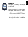
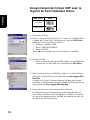
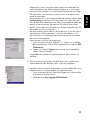
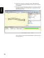
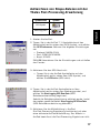
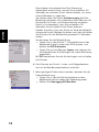
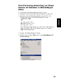
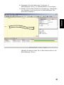
GPSDifferential for ArcPad
™
Getting Started Guide
English
Français
Deutsch
Español
®
English
Table of Contents
Prerequisites ............................................................................. 1
Installing GPSDifferential™ for ArcPad®...................................... 1
Operating Requirements ............................................................. 2
Recommendations...................................................................... 2
Logging Shapefiles with the Magellan Post-Processing Extension .... 3
Post-Processing Shapefiles with
Raw Data in MobileMapper Office................................................ 5
Français
Table des Matières
Préliminaires ............................................................................. 8
Installation de GPSDifferential™ pour ArcPad® ............................ 8
Conditions d’Utilisation .............................................................. 9
Recommandations...................................................................... 9
Enregistrement de fichiers SHP avec le logiciel
de Post-traitement Magellan...................................................... 10
Post-traitement des fichiers SHP et des
données brutes dans MobileMapper Office.................................. 12
Deutsch
Inhalt
Voraussetzungen ...................................................................... 15
Installieren von GPSDifferential™ für ArcPad®........................... 15
Betriebsvoraussetzungen........................................................... 16
Empfehlungen ......................................................................... 16
Aufzeichnen von Shape-Dateien
mit der Magellan Post-Processing-Erweiterung ............................ 17
Post-Processing-Auswertung von
Shape-Dateien mit Rohdaten in MobileMapper Office .................. 19
Español
Índice
Requisitos previos .................................................................... 22
Instalación de GPSDifferential™ para ArcPad® .......................... 22
Requisitos de utilización ........................................................... 23
Recomendaciones .................................................................... 23
Registro de archivos de forma con
el software de posprocesado de Magellan ................................... 24
Posprocesado de archivo de forma con
datos brutos en MobileMapper Office ......................................... 26
English
English
Prerequisites
GPSDifferential™ for ArcPad® requires that you have ESRI's
ArcPad installed first on MobileMapper CX. The extension
supports ArcPad 7.1. Please refer to ArcPad documentation
for more information.
Installing GPSDifferential™ for ArcPad®
1. Insert the “GPSDifferential™ for ArcPad®” SD card into
MobileMapper CX.
2. Using Windows Explorer, browse the SD card and copy the
following files to the MobileMapper CX folders indicated
below:
• PostProc.apa to MyDevice/ESRI ArcPad 7.1/Applets
• PostProc.vbs to MyDevice/ESRI ArcPad 7.1/Applets
• PostProc.dll to MyDevice/ESRI ArcPad 7.1/Extensions
The first time you initiate the Start Logging GPS Raw Data
function when beginning a post-processing differential
job, you will be asked to input the activation code found
on a separate sheet. This sheet (P/N 631309-98) is part
of the supply.
1
English
Operating Requirements
No RTCM source, including MobileMapper Beacon, can be
used with MobileMapper CX when using the post-processing
extension.
The extension is designed in such a way that when you insert
an SD card into the MobileMapper CX unit, raw data will
automatically be logged on the SD card. In the absence of an
SD card, raw data will be logged in the MyDevice folder.
Recommendations
1. Data collected by MobileMapper CX and data drawn in
ArcPad should not be mixed in the same shapefile.
2. Data collected simultaneously by different MobileMapper
CX receivers should be post-processed separately in
MobileMapper Office.
3. If averaging is not used when collecting point data, it is
recommended to remain static on the point for 10 seconds, then create the point and then remain on the point
for a further 10 seconds.
4. ArcPad post-processing results saved in an MMJ job file in
MobileMapper Office cannot be uploaded to MobileMapper or ProMark3. The job’s feature library can however be
exported and uploaded to ProMark3 as an MMF file.
2
English
Logging Shapefiles with the Magellan
Post-Processing Extension
Icon name
Icon
GPS icon
Hammer/
Wrench icon
1. Start ArcPad.
2. In the ArcPad 7.1 tool bar, tap on the down arrow to the
right of the GPS icon and then select the GPS Preferences
option. Make the following settings:
• Protocol: NMEA 0183
• Port: COM2:GPS NMEA
• Baud: 57600
Tap OK to validate the settings and close the window.
3. Activate the GPS section:
• In the ArcPad tool bar, tap on the down arrow to the
right of the GPS icon and select GPS Active.
4. In the ArcPad tool bar, tap on the down arrow to the right
of the Hammer/Wrench icon and select Start logging GPS
Raw Data.
Notice that once the raw data logging is activated, the
command you have just selected is changed to Stop Logging GPS Raw Data.
5. Enable ArcPad averaging:
The post-processing extension works with or without the
averaging being enabled in ArcPad. In fact, ArcPad averaging does not affect post-processing results.
3
English
However, to make sure the post-processing accuracy will
be achieved, it is important that you stay at the collected
point for at least 30 seconds to have adequate raw data
collected.
It is therefore recommended to enable the ArcPad averaging option and select at least 30 positions for point and
vertex averaging. By doing this you will make sure that you
actually stay at the point for at least 30 seconds.
Remember the point is created at the end of the averaging
interval so it is a good idea to stay on the point for about
10 seconds after the averaging screen is closed.
To enable averaging:
• In the ArcPad 7.1 tool bar, tap on the down arrow to
the right of the GPS icon and then select the GPS Preferences option.
• Tap the Capture tab and make the required settings
(see screen opposite).
Tap OK to validate your settings and close the window.
6. Please refer to the ArcPad User Manual to collect point,
line and polygon features.
7. When enough data has been collected, do the following to
stop data logging:
• In the ArcPad tool bar, tap on the down arrow to the
right of the Hammer/Wrench icon.
• Select Stop logging GPS Raw Data.
4
English
Post-Processing Shapefiles with
Raw Data in MobileMapper Office
1. Install MobileMapper Office 3.40a.
2. Copy the collected shapefiles to the PC.
3. Copy the raw data files to the PC. The naming convention
for raw data files is:
yymmddnn.RAW
Where:
yy: Year (e.g. “05”)
mm: Month (e.g. “10”)
dd: Day (e.g. “14”)
nn: Index number that starts from “00” and is incremented by “1” every time a new file is created the same
day.
RAW: Filename extension.
4. Start MobileMapper Office
5. In the File menu, select MobileMapper CX post processing.
5
English
6. Add the shapefile collected in the field using the ArcPad
and Magellan post-processing extension. You may use the
Shift key to add more than one shapefiles.
7. Add the raw data files. You may use the Shift key to add
more than one raw data files.
8. Use the usual MobileMapper Office functions to add reference data
6
English
9. Start the post-processing (same steps as when postprocessing field data collected with MobileMapper Pro).
(Refer to MobileMapper Office User Manual for more
detail.)
7
Français
Préliminaires
Français
GPSDifferential™ pour ArcPad® nécessite l’installation
préalable du logiciel ArcPard de ESRI sur votre MobileMapper
CX. Cette extension logicielle est compatible avec ArcPad 7.1.
Voir la documentation relative à ArcPad pour plus de détails.
Installation de GPSDifferential™ pour
ArcPad®
1. Insérer la carte SD “GPSDifferential™ for ArcPad®” SD
card dans le MobileMapper CX.
2. Avec l’explorateur de Windows, accéder à la carte SD et
copier les fichiers suivants dans les répertoires MobileMapper CX ci-dessous :
• PostProc.apa dans MyDevice/ArcPad 7.1/Applets
• PostProc.vbs dans MyDevice/ArcPad 7.1/Applets
• PostProc.dll dans MyDevice/ArcPad 7.1/Extensions
La première fois que vous sélectionnerez la fonction
"Démarrer l'enregistrement de données brutes" au début
d'un travail en post-traitement différentiel, vous aurez à
rentrer le code d'activation indiqué sur une feuille
séparée. Cette feuille (P/N 631309-98) fait partie de la
fourniture.
8
Aucune source de données RTCM, y compris MobileMapper
Beacon, ne peut être utilisée avec MobileMapper CX lorsque
le logiciel de post-traitement est utilisé.
Cette extension logicielle est conçue de telle manière
qu’après insertion d’une carte SD dans MobileMapper CX, les
données brutes collectées seront systématiquement
enregistrées sur la carte SD. En l’absence de carte SD, elles
seront enregistrées dans le répertoire MyDevice.
Recommandations
1. Les données collectées par MobileMapper CX et les données dessinées dans ArcPad ne doivent pas être
mélangées dans un même fichier forme.
2. Les données collectées simultanément par plusieurs
MobileMapper CX doivent être post-traitées séparément
dans MobileMapper Office.
3. Si le calcul de moyenne n’est pas utilisé lors de la collecte
de points, il est recommandé de rester immobile sur le
point pendant 10 secondes, puis créer le point et enfin
rester encore 10 secondes sur le point.
4. Les résultats de post-traitement ArcPad sauvegardés avec
MobileMapper Office dans un fichier MMJ ne peuvent pas
être chargés dans un MobileMapper ou dans un ProMark3.
La bibliothèque d’entités du job peut cependant être
exportée puis chargée dans un ProMark3 (fichier MMF).
9
Français
Conditions d’Utilisation
Enregistrement de fichiers SHP avec le
logiciel de Post-traitement Thales
Français
Nom icône
Icône
Icône GPS
Icône Outils
1. Démarrer ArcPad.
2. Dans la barre d’outils ArcPad 7.1, taper sur la flèche Bas
à droite de l’icône GPS. Sélectionner l’option GPS Preferences puis faire les choix suivants :
• Protocol : NMEA 0183
• Port: COM2:GPS NMEA
• Baud: 57600
Taper OK pour valider ces choix et fermer la fenêtre.
3. Activer le GPS :
• Dans la barre d’outils d’ArcPad, taper sur la flèche Bas
à droite de l’icône GPS puis sélectionner GPS Active.
4. Dans la barre d’outils d’ArcPad, taper sur la flèche Bas à
droite de l’icône Outils puis sélectionner Start logging GPS
Raw Data.
A noter qu’une fois l’enregistrement de données brutes
démarré, la commande que vous venez de sélectionner se
transforme en Stop Logging GPS Raw Data..
5. Autoriser le calcul de moyenne dans ArcPad :
Le logiciel de post-traitement peut fonctionner avec ou
sans cette fonctionnalité validée dans ArcPad. En réalité,
le calcul de moyenne dans ArcPad ne modifie en rien les
résultats du post-traitement.
10
6. Voir le manuel utilisateur ArcPad User pour savoir comment collecter des entités point, ligne et polygône.
7. Lorsque suffisamment de données ont été collectées, procéder comme suit pour arrêter l’enregistrement :
• Dans la barre d’outils d’ArcPad, taper sur la flèche Bas
à droite de l’icône Outils.
• Sélectionner Stop logging GPS Raw Data.
11
Français
Cependant, pour s’assurer que la précision attendue du
post-traitement soit effectivement obtenue, il est important que vous restiez sur le point étudié pendant au moins
30 secondes, soit le temps nécessaire à une bonne collecte de données.
Par conséquent, il est recommandé de valider l’option ArcPad averaging et de fixer à 30 positions au moins le nombre de données nécessaire au calcul de moyenne pour les
points et les sommets de courbe. En choisissant cette
option, vous serez sûr de rester sur le point pendant les 30
secondes minimum requises.
Ne pas oublier que le point n’est créé qu’à la fin du calcul
de moyenne. C’est pourqoui il est bon de rester sur le
point environ 10 secondes après fermeture de la fenêtre
de calcul de moyenne.
Pour activer le calcul de moyenne :
• Dans la barre d’outils ArcPad 7.1, taper sur la flèche
Bas à droite de l’icône GPS. Sélectionner l’option GPS
Preferences.
• Taper sur l’onglet Capture puis entrer les paramètres
requis (voir ci-contre)..
Taper OK pour valider ces paramètres et pour fermer la
fenêtre.
Post-traitement des fichiers SHP et des
données brutes dans MobileMapper
Office
Français
1. Installer MobileMapper Office 3.40a.
2. Copier les fichiers SHP sur votre PC.
3. Copier les fichiers de données brutes sur votre PC. La convention utilisée pour nommer les fichiers de données brutes est la suivante :
aammjjnn.RAW
Avec :
aa : Année (ex. “05”)
mm : Mois (ex. “10”)
jj : Jour (ex. “14”)
nn : Indice commençant à “00” et incrémenté de “1”
chaque fois qu’un nouveau fichier est créé le même jour.
RAW : Extension du nom de fichier.
4. Lancer MobileMapper Office
5. Dans le menu Fichier, sélectionner Post-traitement
MobileMapper CE.
12
Français
6. Ajouter le fichier SHP collecté sur le terrain avec ArcPad
et le logiciel de post-traitement Thales. Eventuellement
utiliser la touche Shift ( ) pour faire une sélection multiple de fichiers SHP.
7. Ajouter les fichiers de donnés brutes. Eventuellement utiliser la touche Shift ( ) pour faire une sélection multiple
de fichiers de données brutes.
13
Français
8. Utiliser les fonctions habituelles dans MobileMapper
Office pour ajouter des données founies par des stations
de référence.
9. Démarrer le post-traitement (mêmes instructions que lors
du post-traitement de données terrain enregistrées avec
MobileMapper Pro.)
(Voir le Manuel Utilisateur MobileMapper Office pour plus
d’informations.)
14
Deutsch
Voraussetzungen
Installieren von GPSDifferential™ für
ArcPad®
1. Legen Sie die SD-Karte „GPSDifferential™ for ArcPad®“
in den MobileMapper CX ein.
2. Öffnen Sie im Windows Explorer die SD-Karte und kopieren Sie die folgenden Dateien in die unten genannten
Ordner auf dem MobileMapper CX:
• PostProc.apa in MyDevice/ESRI ArcPad 7.1/Applets
• PostProc.vbs in MyDevice/ESRI ArcPad 7.1/Applets
• PostProc.dll in MyDevice/ESRI ArcPad 7.1/Extensions
Beim ersten Aufrufen der Funktion „GPS-Rohdatenaufzeichnung beginnen“ für ein Post-Processing-Projekt müssen Sie den auf einem Blatt beiliegenden
Aktivierungscode eingeben. Dieses Blatt trägt die Artikelnummer 631309-98.
15
Deutsch
GPSDifferential™ für ArcPad® funktioniert nur, wenn Sie
zuerst ESRIs ArcPad auf dem MobileMapper CX installieren.
Die Erweiterung unterstützt ArcPad 7.1. Weitere
Informationen finden Sie in der ArcPad-Dokumentation.
Betriebsvoraussetzungen
Mit dem MobileMapper CX darf keine RTCM-Quelle
(einschließlich MobileMapper Beacon) verwendet werden,
wenn Sie die Post-Processing-Erweiterung einsetzen.
Die Erweiterung speichert automatisch Rohdaten auf einer in
den MobileMapper CX eingelegten SD-Karte. Ist keine SDKarte eingelegt, werden die Rohdaten im Ordner MyDevice
abgelegt.
Deutsch
Empfehlungen
1. Sie sollten Daten, die mit MobileMapper CX erfasst wurden, nicht in einer Shapedatei mit Daten, die in ArcPad
gezeichnet wurden, mischen.
2. Gleichzeitig von verschiedenen MobileMapper-CE-Empfängern erfasste Daten sollten getrennt voneinander in
MobileMapper Office ausgewertet werden.
3. Wenn keine Mittelbildung bei der Erfassung von Punktdaten verwendet wird, sollten Sie mindestens 10
Sekunden ruhig auf dem Punkt stehen bleiben, dann den
Punkt erstellen und weitere 10 Sekunden stehen bleiben.
4. In MobileMapper Office in einer MMJ-Projektdatei gespeicherte ArcPad-Post-Processing-Ergebnisse können
nicht zum MobileMapper oder ProMark3 übertragen werden. Die Featurebibliothek des Projekts kann jedoch problemlos als MMF-Datei exportiert und zum ProMark3
übertragen werden.
16
Aufzeichnen von Shape-Dateien mit der
Thales Post-Processing-Erweiterung
Symbolname
Symbol
GPS-Symbol
1. Starten Sie ArcPad.
2. Tippen Sie in der ArcPad 7.1-Symbolleiste auf den
Abwärtspfeil rechts neben dem GPS-Symbol, und wählen
Sie GPS Preferences. Nehmen Sie folgende Einstellungen
vor:
• Protocol: NMEA 0183
• Port: COM2:GPS NMEA
• Baud: 57600
PMit OK übernehmen Sie die Einstellungen und schließen
das Fenster.
3. Aktivieren Sie den GPS-Abschnitt:
• Tippen Sie in der ArcPad-Symbolleiste auf den
Abwärtspfeil rechts neben dem GPS-Symbol, und
wählen Sie GPS Active (GPS aktiv).
4. Tippen Sie in der ArcPad-Symbolleiste auf den
Abwärtspfeil rechts neben dem Werkzeugsymbol, und
wählen Sie Start logging GPS Raw Data (GPSRohdatenaufzeichnung beginnen).
Sobald die Rohdatenaufzeichnung aktiviert wurde, lautet
der soeben gewählte Befehl Stop Logging GPS Raw Data
(GPS-Rohdatenaufzeichnung beenden).
5. Aktivieren Sie die Mittelbildung in ArcPad:
Die Post-Processing-Erweiterung funktioniert mit oder
ohne aktivierte ArcPad-Mittelbildung. Das Mitteln in
ArcPad beeinflusst die Post-Processing-Ergebnisse nicht.
17
Deutsch
Werkzeugsymbol
Deutsch
Damit jedoch die erforderliche Post-ProcessingGenauigkeit erreicht wird, müssen Sie mindestens 30
Sekunden am erfassten Punkt stehen bleiben, um ausreichend Rohdaten zu speichern.
Sie sollten daher die Option ArcPad averaging (ArcPadMittelung) aktivieren und mindestens einen Wert von 30
Positionen für Punkt- und Eckenmittelung einstellen.
Damit ist sichergestellt, dass Sie mindestens 30
Sekunden lang an jedem Punkt Daten erfassen.
Denken Sie daran, dass der Punkt am Ende der Mittelbildung erstellt wird. Bleiben Sie daher nach dem Schließen
des Fensters für die Mittelbildung weitere 10 Sekunden
stehen.
So aktivieren Sie die Mittelbildung:
• Tippen Sie in der ArcPad 7.1-Symbolleiste auf den
Abwärtspfeil rechts neben dem GPS-Symbol, und
wählen Sie GPS Preferences.
• Tippen Sie auf das Register Capture und nehmen Sie
die erforderlichen Einstellungen vor (siehe Abbildung
gegenüber).
Mit OK übernehmen Sie die Einstellungen und schließen
das Fenster.
6. Das Erfassen von Punkt-, Linien- und Polygonfeatures
wird im ArcPad-Benutzerhandbuch erläutert.
7. Wenn genügend Daten erfasst wurden, beenden Sie die
Datenaufzeichnung:
• Tippen Sie in der ArcPad-Symbolleiste auf den
Abwärtspfeil rechts neben dem Werkzeugsymbol.
• Wählen Sie Stop logging GPS Raw Data.
18
1. Installieren Sie MobileMapper Office 3.40a.
2. Kopieren Sie die erfassten Shape-Dateien auf den PC.
3. Kopieren Sie die Rohdatendateien auf den PC. Die
Namenskonvention für Rohdatendateien lautet:
jjmmttnn.RAW
Wo:
jj: Jahr (z.B. „05“)
mm: Monat (z.B. „10“)
tt: Tag (z.B. „14“)
nn: Indexzahl, beginnend mit „00“. Der Index wird für
jede am selben Tag neu erstellte Datei um 1 erhöht.
RAW: Dateierweiterung.
4. Starten Sie MobileMapper Office.
5. Wählen Sie im Menü Datei den Eintrag MobileMapper CE
post processing.
19
Deutsch
Post-Processing-Auswertung von ShapeDateien mit Rohdaten in MobileMapper
Office
6. Fügen Sie die im Feld erfasste Shape-Datei über die
Thales Post-Processing-Erweiterung für ArcPad hinzu. Sie
können die Umschalttaste verwenden, um mehrere ShapeDateien auszuwählen.
Deutsch
7. Fügen Sie die Rohdatendateien hinzu. Sie können die
Umschalttaste verwenden, um mehrere Rohdatendateien
auszuwählen.
20
Deutsch
8. Verwenden Sie die bekannten Funktionen in
MobileMapper Office, um Referenzdaten hinzuzufügen.
9. Starten Sie die Post-Processing-Auswertung. (Verwenden
Sie dieselben Schritte wie bei mit MobileMapper Pro
erfassten Felddaten.)
(Weitere Hinweise finden Sie im Benutzerhandbuch von
MobileMapper Office.)
21
Español
Requisitos previos
GPSDifferential™ para ArcPad® requiere que se haya
instalado previamente ArcPad de ESRI en el MobileMapper
CX. Esta extensión de software es compatible con ArcPad 7.1.
Consulte la documentación de ArcPad para obtener más
información.
Instalación de GPSDifferential™ para
ArcPad®
Español
1. Introduzca la tarjeta SD “GPSDifferential™ for ArcPad®”
en el MobileMapper CX.
2. Desde el Explorador de Windows, examine la tarjeta SD y
copie los siguientes archivos a las carpetas del MobileMapper CX indicadas a continuación:
• PostProc.apa a MyDevice/ESRI ArcPad 7.1/Applets
• PostProc.vbs a MyDevice/ESRI ArcPad 7.1/Applets
• PostProc.dll a MyDevice/ESRI ArcPad 7.1/Extensions
La primera vez que lance la función Iniciar registro de
datos brutos GPS al empezar un trabajo diferencial de
posprocesado, se le pedirá que introduzca el código de
activación que puede encontrar en una hoja independiente. Esta hoja (P/N 631309-98) es parte del material
proporcionado.
22
Requisitos de utilización
No se puede usar ninguna fuente de datos RTCM, incluido
MobileMapper Beacon, con MobileMapper CX mientras se
utiliza la extensión de posprocesado.
La extensión está diseñada de modo que, al introducir una
tarjeta SD en la unidad MobileMapper CX, los datos brutos se
registrarán automáticamente en dicha tarjeta. En ausencia de
tarjeta SD, los datos brutos se registrarán en la carpeta
MyDevice.
1. Los datos recogidos por el MobileMapper CX y los datos
dibujados en ArcPad no se deben mezclar en el mismo
archivo de forma.
2. Los datos recogidos simultáneamente por diferentes
receptores MobileMapper CX se deben posprocesar por
separado en MobileMapper Office.
3. Si no se emplea el promedio al recoger datos de puntos,
es recomendable permanecer estático en el punto durante
10 segundos, luego crear el punto y después permanecer
en el punto 10 segundos más.
4. Los resultados de posprocesado de ArcPad guardados en
un archivo de trabajo MMJ en MobileMapper Office no se
pueden cargar en un MobileMapper o ProMark3. No
obstante, la lista de entidades del trabajo se puede exportar y cargar en un ProMark3 como archivo MMF.
23
Español
Recomendaciones
Registro de archivos de forma con el
software de posprocesado de Thales
Nombre de
icono
Icono
Icono GPS
Icono Martillo/
Llave
Español
1. Inicie ArcPad.
2. En la barra de herramientas de ArcPad 7.1, puntee la
flecha hacia abajo a la derecha del icono GPS y seleccione
GPS Preferences. Establezca las opciones siguientes :
• Protocol: NMEA 0183
• Puerto: COM2:GPS NMEA
• Baudio: 57600
Puntee OK para validar las opciones y cerrar la ventana.
3. Active la sección GPS:
• En la barra de herramientas de ArcPad, puntee la
flecha hacia abajo a la derecha del icono GPS y
seleccione GPS Active (GPS Activo).
4. En la barra de herramientas de ArcPad, puntee la flecha
hacia abajo a la derecha del icono "Martillo/Llave" y
seleccione Start logging GPS Raw Data (Iniciar registro de
datos brutos GPS).
Observe que, una vez activado el registro de datos brutos,
el comando que acaba de seleccionar se convierte en Stop
Logging GPS Raw Data (Detener registro de datos brutos
GPS).
5. Activar el promediado de ArcPad:
La extensión de posprocesado funciona con o sin el
promediado habilitado en ArcPad. De hecho, el
promediado de ArcPad no afecta a los resultados de
posprocesado.
24
6. Consulte el Manual de usuario de ArcPad para recoger
entidades puntuales, lineales y poligonales.
7. Una vez recogidos suficientes datos brutos, haga lo
siguiente para detener el registro de datos:
• En la barra de herramientas de ArcPad, puntee la
flecha hacia abajo a la derecha del icono “Martillo/
Llave”.
• Seleccione Stop logging GPS Raw Data.
25
Español
Sin embargo, para garantizar que se consigue la precisión
del posprocesado, es importante que permanezca en el
punto recogido durante al menos 30 segundos, a fin de
que se recojan los datos brutos adecuados.
Por tanto, es recomendable activar la opción ArcPad
averaging (Promediado de ArcPad) y seleccionar al menos
30 posiciones para el promediado de puntos y vértices. De
este modo, podrá estar seguro de permanecer en el punto
durante al menos 30 segundos.
Recuerde que el punto se crea al final del intervalo de promedio, por lo que es aconsejable quedarse en el punto
unos 10 segundos después de que se cierre la pantalla de
promedio.
Para activar el promediado:
• En la barra de herramientas de ArcPad 7.1, puntee la
flecha hacia abajo a la derecha del icono GPS y
seleccione GPS Preferences.
• Puntee la ficha Capture y establezca las opciones
oportunas (véase la pantalla al lado):
Puntee OK para validar las opciones y cerrar la ventana.
Posprocesado de archivo de forma con
datos brutos en MobileMapper Office
Español
1. Instale MobileMapper Office 3.40a.
2. Copie los archivos de forma recogidos en el ordenador.
3. Copie los archivos de datos brutos en el ordenador. El
convenio de denominación de archivos de datos brutos es:
aammddnn.RAW
Donde:
aa: año (p. ej. “05”)
mm: mes (p. ej. “10”)
dd: día (p. ej. “14”)
nn: Número de índice que empieza en “00” y se
incrementa en “1” cada vez que se crea un nuevo archivo
el mismo día.
RAW: Extensión del nombre del archivo.
4. Inicie MobileMapper Office
5. En el menú Archivo, seleccione MobileMapper CE post
processing (Posprocesado).
26
Español
6. Agregue el archivo de forma recogido sobre el terreno
mediante ArcPad y la extensión de posprocesado de
Thales. Puede utilizar la tecla Mayús para agregar más de
un archivo de forma.
7. Agregue los archivos de datos brutos. Puede utilizar la
tecla Mayús para agregar más de un archivo de datos
brutos.
27
8. Utilice las funciones habituales de MobileMapper Office
para añadir datos de referencia
9. Inicie el posprocesado (Siga los mismos pasos que al
posprocesar datos de campo recogidos con MobileMapper
Pro.)
Español
(Si desea saber más detalles, consulte el Manual de
usuario de MobileMapper Office.)
28
GPSDifferential™ for ArcPad®
Getting Started Guide
English
Français
Deutsch
Español
GPSDifferential for ArcPad
™
®
Getting Started Guide
Guide de démarrage
Kurzanleitung
Guía básica de utilización
Magellan
Mobile Mapping Solutions Contact Information:
In USA +1 408 615 3970 I Fax +1 408 615 5200
Toll Free (Sales in USA/Canada) 1 800 922 2401
In South America +56 2 273 3214 I Fax +56 2 273 3187
Email [email protected]
In Singapore +65 9838 4229 I Fax +65 6777 9881
In China +86 10 6566 9866 I Fax +86 10 6566 0246
Email [email protected]
In France +33 2 28 09 38 00 I Fax +33 2 28 09 39 39
In Germany +49 81 6564 7930 I Fax +49 81 6564 7950
In Russia +7 495 980 5400 I Fax +7 495 981 4840
In the Netherlands +31 78 61 57 988 I Fax +31 78 61 52 027
Email [email protected]
www.pro.magellangps.com
Magellan follows a policy of continuous product improvement; specifications and descriptions are thus subject to change without notice. Please contact Magellan for the latest product information.
©2005-2007 Magellan Navigation, Inc. All rights reserved. ArcPad is a registered trademark of Environmental Systems Research Institute, Inc. All other product and brand names are trademarks of
their respective holders. P/N 631307-99E