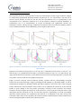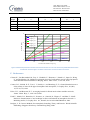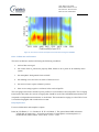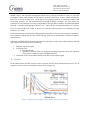
1
Title: Data User Guide Deliverable number: D 4.2 Revision 00 - Status: Final Date of issue: 08/05/2013 Data User Guide Deliverable title Deliverable number Revision Status Planned delivery date Date of issue Nature of deliverable Lead partner Dissemination level Data User Guide D4.2 00 Final 30/04/2013 08/05/2013 Report BIRA-IASB Public This work has received research funding from the European Community's Seventh Framework Programme ([FP7/2007-2013]) under grant agreement n°284421. Title: Data User Guide Deliverable number: D 4.2 Revision 00 - Status: Final Date of issue: 08/05/2013 DOCUMENT PROPERTIES LEAD AUTHOR CONTRIBUTING AUTHORS FUNCTION NAME ORGANISATION DATE Research Associate M. De Mazière BIRA-IASB Research Associate A. Richter Univ. Bremen Research Associate M. Pastel LATMOS/CNRS Research Associate F. Hendrick BIRA-IASB Research Associate B. Langerock BIRA-IASB Research Associate K. Hocke IAP/U. Bern 5/5/2013 SIGNATURE Title: Data User Guide Deliverable number: D 4.2 Revision 00 - Status: Final Date of issue: 08/05/2013 Table of Contents Executive summary Contents I. FOURIER-TRANSFORM INFRARED SPECTROMETRY (FTIR) 7 A. Instrument fiche ........................................................................................................................... 7 B. Operation mode ........................................................................................................................... 9 C. L1 data ....................................................................................................................................... 11 D. L1 L2 data processing principles ............................................................................................. 11 E. L2 data and use caveats ............................................................................................................. 12 F. Including concept/examples of horizontal/vertical averaging ................................................... 13 G. References ................................................................................................................................. 15 II. DOAS / MAXDOAS 16 A. Instrument fiche ......................................................................................................................... 16 B. Operation mode ......................................................................................................................... 18 C. L1 data ....................................................................................................................................... 19 D. L1 ->L2 data processing principles.............................................................................................. 20 E. L2 data and use caveats including concept/examples of horizontal/vertical averaging............. 21 F. References ................................................................................................................................. 28 III. OZONE MICROWAVE RADIOMETRY 29 A. Intro (general) ............................................................................................................................ 29 A.1 Instrument fiche 29 A.2 Measurement technique 30 A.3 Data analysis 32 B. Ozone microwave radiometers of NORS: GROMOS and OZORAM........................................ 33 B.1 GROMOS (Ground-based Millimeter-wave Ozone Spectrometer) 33 B.2. OZORAM 35 IV. OZONE DIAL A. Instrument fiche ......................................................................................................................... 38 B. Operation mode ......................................................................................................................... 39 C. L1 data ....................................................................................................................................... 41 D. L1 ->L2 data processing principles.............................................................................................. 42 E. L2 data and use caveats (hdf) ..................................................................................................... 43 F. Including concept/examples of horizontal/vertical averaging ................................................... 43 G. References ................................................................................................................................. 44 38 Title: Data User Guide Deliverable number: D 4.2 Revision 00 - Status: Final Date of issue: 08/05/2013 List of tables Table 1. FTIR Instrument fiche. Adapted from [ISSI, 2012, Annex A.1.3]. ............................................... 7 Table 2. Example of a ray tracing output for an FTIR measurement of CH4 at St Denis (-20.9°S, 55.5°E), Ile de La Réunion, on 25/1/2011 04:04 UT for a solar zenith angle of 62°. ............................. 15 Table 3. Example of a ray tracing output for O3 providing the geographical location of the points along the line of sight corresponding to a percentage of the total O3 column (measurement on 25/1/2011 4:04 UT with solar zenith angle 62° .................................................................................... 15 Table 4. DOAS/MAXDOAS instrument fiche ......................................................................................... 16 Table 5. Ozone Microwave Radiometry, instrument fiche ................................................................... 29 Table 6. GROMOS, instrument fiche..................................................................................................... 33 Table 7. OZORAM, instrument fiche ..................................................................................................... 35 Table 8. Ozone DIAL, instrument fiche ................................................................................................. 38 Title: Data User Guide Deliverable number: D 4.2 Revision 00 - Status: Final Date of issue: 08/05/2013 List of figures Figure 1. Experimental set-up ................................................................................................................ 9 Figure 2. Example of an interferogram and associated spectrum, in the spectral range 2450-3200 cm1, recorded on April 24, 2012 at St. Denis, Ile de La Réunion (21°S, 55°E, approximately sea level). ... 10 Figure 3. Example of the spectral microwindow 1002-1003 cm-1 which contains several ozone absorption lines, from a spectrum taken at St Denis, Ile de La Réunion. ............................................. 11 Figure 4. Example of ozone retrieval (left plot: green profile is the a priori; blue profile is the retrieved one) and associated averaging kernel in VMR/VMR units (right plot). The dashed curve in the latter plot represents the sensitivity curve (see text). ................................................................................... 13 Figure 5. Example of the light path for a measurement at St Denis Ile de La Réunion with a high solar zenith angle. ......................................................................................................................................... 14 Figure 6. Experimental setup................................................................................................................ 18 Figure 7. Example of two spectra taken during the CINDI campaign in Cabauw .................................. 19 Figure 8. Example NO2 differential slant columns (1v2a) ..................................................................... 21 Figure 9. typical examples of MAX-DOAS profiles and averaging kernels for NO2, HCHO, and aerosol retrievals. ............................................................................................................................................. 22 Figure 10. Typical examples of ozone and NO2 column averaging kernels computed for 90° SZA sunset and 45°N in April. ................................................................................................................................. 23 Figure 11. Example for retrievals (top) and averaging kernels (bottom) of the aerosol extinction profile based on synthetic measurements. .......................................................................................... 24 Figure 12. Example for the impact of the aerosol extinction profile on the NO2 retrieval. Left: Aerosol extinction profile; middle: NO2 Box-Airmass-Factors; right: NO2 averaging kernels. .......................... 25 Figure 13. Relationships between the retrieved O4 DSCD and the horizontal sensitivity range for selected elevation angles and wavelengths (SZA: 60°: relative azimuth angles: 0°, 90°, 180°). The different colours represent results for different aerosol extinction (box) profiles. .............................. 27 Figure 14. Relationships between altitude and horizontal distance of an air mass observed by MAXDOAS observations for different elevation angles. The effect of the earth’s curvature is taken into account................................................................................................................................................. 28 Figure 15. A typical ozone microwave radiometer (GROMOS at Bern) ................................................ 30 Figure 16. Frontend with quasi optics of the microwave radiometer. ................................................. 30 Figure 17. Flow chart of the measurement process ............................................................................. 31 Figure 18. Flow chart of the data retrieval. .......................................................................................... 32 Figure 19. Time series of strato-mesospheric Ozone measured using the OZORAM ........................... 37 Figure 20. Schematic view of the principle of a lidar system. ............................................................... 40 Figure 21. Temporal signal averaging in order to increase the signal-to-noise ratio. ........................... 41 Figure 22. Precision and vertical resolution profile of an ozone measurement in the case of the OHP (Observatoire de Haute Provence –in France) lidar instrument. Both the precision and the vertical resolution profile depend on the experimental configuration. The precision can vary from one measurement to the other. .................................................................................................................. 44 Title: Data User Guide Deliverable number: D 4.2 Revision 00 - Status: Final Date of issue: 08/05/2013 EXECUTIVE SUMMARY Title: Data User Guide Deliverable number: D 4.2 Revision 00 - Status: Final Date of issue: 08/05/2013 CONTENTS I. Fourier-transform Infrared Spectrometry (FTIR) A. Instrument fiche Table 1. FTIR Instrument fiche. Adapted from [ISSI, 2012, Annex A.1.3]. Instrument Platform Measuring technique Observation geometry Units Vertical resolution Horizontal resolution Temporal resolution Vertical range Horizontal range Stability/drift Precision Systematic uncertainty Daytime/ nighttime Weather conditions Interferences/ contamination (payload, spectral) Bottlenecks, limitations Fourier transform infrared spectrometer (Michelson-type interferometer) ground-based Solar (or lunar) absorption spectrometry Looking directly at the center of the sun (or the moon) Total columns (mol/cm2) and volume mixing ratio per atmospheric layer (vmr) and partial column per atmospheric layer (mol/cm2) A few km to 10 km Depending on solar zenith angle of measurement and vertical profile of the target species: the horizontal resolution decreases as the SZA increases and if the target gas is located higher in the atmosphere. Depending on the spectral resolution and number of interferometer scans per spectrum (the higher the spectral resolution and the number of scans per spectrum, the worse the temporal resolution) 0-70 km about 5x5km at 50 km avoided by instrument line shape verifications with a known cell measurement (typically HBr or N2O) Mainly determined by spectroscopic uncertainties (5 – 20%) Only daytime for solar absorption; nighttime data with lunar absorption are generally less precise Stable optical depth is required in FOV; essentially clear sky is required Minor contaminations due to spectroscopic interferences with other species, like H2O, CH4, …. In general they are minimized. Large, heavy and expensive instrument; limited or no transportability; open view to the sun is required all day; air-conditioned room is required. The instrument must be operated with a Title: Data User Guide Deliverable number: D 4.2 Revision 00 - Status: Final Date of issue: 08/05/2013 Absolute or calibration needed? Corrections needed? Auxiliary data Averaging kernels A priori information Spectroscopic parameters Transportability/ Suitability for campaign System availability Data processing time Additional products Future potential Caveats reliable suntracking system. Self-calibrating technique (differential absorption principle) No Pressure / Temperature profiles from local observations or NCEP. Important component of the retrieval products (L2): give information about sensitivity of the data products to the true and the a priori profiles. A priori information on atmospheric vertical profiles for target and interfering species is required in the L1-> L2 retrieval process; taken from WACCM output; sometimes adjusted via a dedicated pre-fit of observed spectra. from spectroscopic databases (HITRAN or pseudolines from JPL (G. Toon) or specific databases) Bruker 120/125 M is transportable and therefore suitable for campaigns; Bruker 120/125 HR are not transportable unless if installed in a transportable container. Commercial spectrometers The goal is to deliver L2 data within 1 month after spectra acquisition Interfering species concentrations, in particular H2 O Delivery of more species, more information about isotopologues for some species (H2O, CO, CH4,…); delivery of horizontal averaging kernels ? Averaging kernels (vertical and horizontal) and a priori information required for proper interpretation of the L2 data. Title: Data User Guide Deliverable number: D 4.2 Revision 00 - Status: Final Date of issue: 08/05/2013 B. Operation mode Figure 1. Experimental set-up Figure 1 shows an experimental setup. Top left: meteostation; top right: suntracker; bottom: Fourier transform spectrometer. The meteo station includes a Vaisala wind/humidity/rain detector (in the red circle), a sunshine detector (total solar irradiance) (in the green circle), a high-precision barometer (in the orange circle) and a presence-of-rain detector (in the yellow circle). Title: Data User Guide Deliverable number: D 4.2 Revision 00 - Status: Final Date of issue: 08/05/2013 The solar (lunar) light is guided into the spectrometer by a precise suntracker that follows the sun during the day. The system has an active feedback system, in order to keep the sun image at all times centered on the entrance aperture of the spectrometer. The alignment of the solar beam in the spectrometer is critical, and is verified regularly with a cell measurement: the measurement with highspectral resolution (of order 0.003 cm-1) of the absorption spectrum of a known gas (e.g., HBr, N 2O, CS2) with a known concentration at low pressure in the cell reveals the instrument line shape and permits verification of the alignment. The spectrometer is equipped with an InSb detector covering the range 1 to 5 µm, and a HgCdTe detector covering the range 1.5 to 16 µm. Both detectors are cooled to liquid N2 temperatures. The recorded signal (L0) is an interferogram, which is then transformed via a Fast Fourier Transform (FFT) algorithm into a spectrum (L1 data) (Figure 2). In order to increase the signal-to-noise ratio, an optical filter in front of the detector limits the spectral bandwidth of the recorded spectra. The interferogram corresponds to the AC part of the detector signal; ideally the DC part is also recorded to verify the signal strength. For operational measurements the ground-based FTIR spectra are measured with a typical resolution of about 0.005 cm−1 (i.e. maximum optical path difference, OPD, of 180 cm), which corresponds to a resolution λ/λ at 1000 cm-1 of approx. 2×10⁵. To increase even more the signal-to-noise ratio, several interferometer scans may be co-added before transformation into a spectrum. Recording of one spectrum requires between one to a few tens of minutes, depending on the required spectral resolution and signal-to-noise ratio. During the whole recording time, the solar (lunar) intensity (in the infrared) must be stable. This can be guaranteed only with completely clear sky. In many instances, and especially in remote locations, the experiment is performed in automatic or remote control mode. This requires knowledge about the meteorological conditions, via a small meteorological station. Most important meteo parameters are the presence of rain, in which case the suntracker must be closed, the solar irradiance, to verify the solar intensity, and the local surface pressure and temperature. Additional parameters are wind speed and direction, and local humidity. The meteorological data are stored at a high frequency (of order 1s). In some cases, the spectral radiances are calibrated against a blackbody – see [ISSI, 2012]. Figure 2. Example of an interferogram and associated spectrum, in the spectral range 2450-3200 cm-1, recorded on April 24, 2012 at St. Denis, Ile de La Réunion (21°S, 55°E, approximately sea level). Title: Data User Guide Deliverable number: D 4.2 Revision 00 - Status: Final Date of issue: 08/05/2013 C. L1 data As explained above, the L1 data are spectra, covering a given spectral bandwidth. Some preprocessing is performed before they are ingested in the inversion to derive the L2 products. The preprocessing essentially includes re-formatting, calculation of the solar zenith and azimuth angle characterizing the spectrum, synchronization between the spectra and the meteorological data, and rejection of bad spectra, based on the meteorological parameters and the detector DC signal. D. L1 L2 data processing principles The observed spectra (I as a function of wavenumber ) are representative of the absorption of the solar beam along the line of sight (s) in the atmosphere. In other words, they provide integrated information along the line of sight, which is completely determined by the geographical location of the spectrometer, and the solar (lunar) zenith and azimuth angles associated with the spectrum. The latter parameters are all included in the data files. Figure 3 provides an example of a spectrum in the window 1002-1003 cm-1 in which several ozone absorption lines are present. -1 Figure 3. Example of the spectral microwindow 1002-1003 cm which contains several ozone absorption lines, from a spectrum taken at St Denis, Ile de La Réunion. The retrieval process or inversion (L1 L2) consists of extracting from the spectra the information about the absorbers’ concentrations and vertical distributions in the atmosphere, based on the basic radiative transfer equations (Schwarzwild’s equation): dI ( s 0 , s ) ext I ( s ) ds ext J ( s ) ds ext ( I ( s ) J ( s )) ds (1) Title: Data User Guide Deliverable number: D 4.2 Revision 00 - Status: Final Date of issue: 08/05/2013 In the solar absorption case, the only source term (J) to be considered is the sun, and in the infrared, one can omit scattering and therefore, the extinction coefficient ( ext) reduces to the absorption coefficient (abs). The equation can be re-written as: ∫ ( ) (2) in which x(s) is the absorber’s concentration at position s along the line of sight. The equation is written in the case of one single absorber; in practice of course, the extinction factors due to every single absorber must be multiplied. The ‘inversion’ of this equation enables therefore the determination of the absorbers’ concentrations, assuming perfect knowledge of the light path trajectory and of the absorption coefficients and their dependence on P and T. In practice, the solution of the equation is not unequivocal (ill-posed problem) and some a priori knowledge must be used to find the most probable solution. The methods most often used at present are the Optimal Estimation Method and Tikhonov regularization [Rodgers, 2000]. The mathematics are shortly summarized in [ISSI, 2012]. The inversion then yields the retrieved vertical distribution xr along the vertical (z) of the target absorber(s) in the atmosphere: (3) in which xa and xt are the a priori and true vertical profiles of the target absorber, respectively, and A is a product of the retrieval process, the so-called Averaging Kernel (a square matrix). E. L2 data and use caveats The L2 data consist of the retrieved vertical profiles on a vertical altitude grid. , expressed as a volume mixing ratio (VMR) In addition, the data files also provide the integrated profiles or total columns and the partial columns per altitude layer defined by the layer altitude boundaries. With each variable, the associated random, systematic and total uncertainty is provided – see Guide to Data Uncertainties. Since water vapour is an important interfering gas in the infrared, and since it is important to distinguish between the dry air VMR and the wet air VMR, the concentration profiles of H 2O are also provided in the data files. One must be careful as to whether the VMR is specified as an effective mean VMR in the corresponding altitude layer, defined by the altitude boundaries, or as a VMR on one of the layer boundaries: this is explained in the variable descriptions associated with the ALTITUDE, ALTITUDE.BOUNDARIES, MIXING.RATIO and COLUMN.PARTIAL variables in the data files. One must be well aware about the interpretation of the retrieved vertical profiles: The above equation (3) tells you how the retrieved profile is related to the true profile and what the contribution is of the a priori in the retrieved profile. An averaging kernel close to the identity matrix tells you that the retrieval is close to the truth and the a priori contribution is very small. An averaging Title: Data User Guide Deliverable number: D 4.2 Revision 00 - Status: Final Date of issue: 08/05/2013 kernel close to zero tells you that you’re almost reproducing the a priori, in other words, the measurements have not added a lot of information. The averaging kernel also provides you the information about the vertical resolution: the vertical resolution cannot be expressed as a single number; rather it is described by the convolution of the true profile with the averaging kernel. Both xa and A are provided in the data files. A determines the so-called smoothing error of the retrieval products, as described in the Guide to Data Uncertainties. F. Including concept/examples of horizontal/vertical averaging Vertical averaging Figure 4. Example of ozone retrieval (left plot: green profile is the a priori; blue profile is the retrieved one) and associated averaging kernel in VMR/VMR units (right plot). The dashed curve in the latter plot represents the sensitivity curve (see text). The above picture presents a typical averaging kernel (AVK) matrix for an O3.retrieval. The AVK matrix is defined on the same vertical grid as the retrieved profile. The colored curves in the plot are the rows of the AVK matrix where each element in a row is plotted against the corresponding height grid. Each curve or row of the AVK is color coded according to the height of the corresponding row index (see horizontal lines). The sensitivity curve represents the fractional sensitivity of the retrieved profile at each altitude to the measurement. The AVK matrix determines how the retrieved profile is related to the true and the a priori profiles, according to Eq. (3). For example, the retrieved profile at 40 km altitude is obtained from Eq. (3) with the row of AVK corresponding to 40km, i.e., the yellow curve in the AVK plot in Figure 4. The yellow curve has a peak at 40km, but has non vanishing terms on the nearby altitude layers. Ideally each row has a single discrete peak at its corresponding height, but in OEM the retrieved information at a certain altitude is obtained also from nearby layers. And at higher altitudes there is no Title: Data User Guide Deliverable number: D 4.2 Revision 00 - Status: Final Date of issue: 08/05/2013 information at all (the red lines tend to zero). There the retrieved profile reproduces the a priori vertical profile. Comparing FTIR retrieved profiles with other ‘reference’ data (e.g. model, satellite) requires that these reference data undergo the same ‘averaging’ of information as a function of altitude (i.e., convolution with the averaging kernel) in order to obtain comparable objects. E.g., one does not wish to obtain an apparent bias at altitudes where the measurement has no sensitivity. This averaging or smoothing of the reference data is essentially Equation (3), where is replaced by the reference data. Horizontal averaging The retrieved profiles are not measured exactly at the instruments location: depending on the solar zenith and azimuth angles, the line of sight differs. A horizontal averaging kernel of a measurement describes the relationship between the information in the retrieved profile and its geographical location. These horizontal averaging kernels are not available in the HDF data files and FTIR data users should realize that the data is not geographically located at the instruments location. The users can estimate the geographical location of the information from the solar and azimuth angles that are provided in the HDF files and a ray-tracing tool. Figure 5. Example of the light path for a measurement at St Denis Ile de La Réunion with a high solar zenith angle. Title: Data User Guide Deliverable number: D 4.2 Revision 00 - Status: Final Date of issue: 08/05/2013 Table 2. Example of a ray tracing output for an FTIR measurement of CH4 at St Denis (-20.9°S, 55.5°E), Ile de La Réunion, on 25/1/2011 04:04 UT for a solar zenith angle of 62° and an azimuth angle of 101° measured from N (0°) to E (90°). The Table provides the geographical location of the points along the line of sight corresponding to a percentage of the total CH 4 column. Latitude (° North) Percentage 0 20 40 60 80 -20.900 -20.906 -20.912 -20.921 -20.934 Longitude (° East) 55.480 55.511 55.546 55.596 55.666 Altitude (km) 0.05 1.8 3.8 6.6 10.6 Distance from instrument location (km) 0.0 3.3 7.0 12.3 19.7 Table 3. Example of a ray tracing output for O3 providing the geographical location of the points along the line of sight corresponding to a percentage of the total O3 column (measurement on 25/1/2011 4:04 UT with solar zenith angle 62° and azimuth angle 101° (measured from N (0°) to E(90°)) Percentage Latitude North (°) 0 20 40 60 80 -20.900 -20.947 -20.963 -20.975 -20.991 Longitude East (°) 55.480 55.740 55.827 55.893 55.980 Altitude (km) 0.1 14.8 19.8 23.6 28.6 Distance from instrument location (km) 0.0 27.5 36.8 43.8 53.0 G. References ISSI, 2012: Schneider, Matthias, Philippe Demoulin, Ralf Sussmann, and Justus Notholt, Fourier Transform Infrared Spectrometry, Chapter 6 in Monitoring Atmospheric Water Vapour, Ground-Based Remote Sensing and In-situ Methods, ISSI Scientific Report Series, Vol. No. 10 (Editor Niklaus Kämpfer), Springer, DOI 10.1007/978-1-4614-3909-7, 2012, ISBN 978-1-4614-3908-0, 2013. Rodgers, C. D., Inverse methods for atmospheric sounding, Series on Oceanic and planetary physics – vol. 2, World Scientific, 2000. Title: Data User Guide Deliverable number: D 4.2 Revision 00 - Status: Final Date of issue: 08/05/2013 II. DOAS / MAXDOAS A. Instrument fiche Table 4. DOAS/MAXDOAS instrument fiche Instrument Multi-AXis Differential Optical Absorption Spectrometer (MAX-DOAS) Platform ground-based Measuring technique Solar light absorption spectrometry Observation geometry Looking at scattered light from the zenith and various directions above the horizon. Some instruments also perform direct sun observations. Units Total columns (mol/cm2) and volume mixing ratio per atmospheric layer (vmr) and partial column per atmospheric layer (mol/cm2) Vertical resolution Strongly varying from 100 m close to the ground to column above 5 km Horizontal resolution Depending on solar zenith angle of measurement, vertical layer position and wavelength range used and atmospheric aerosol load and vertical profile of the target species: the horizontal resolution decreases as the SZA increases and if the target gas is located higher in the atmosphere. In the boundary layer, it decreases with increasing aerosol load and towards shorter retrieval wavelengths. Temporal resolution Better than 1 minute for tropospheric column, 10 minutes for stratospheric columns at twilight, typically 15 – 30 minutes for profile in the troposphere Vertical range 0-70 km Horizontal range 0 – 50 km in the troposphere Stability/drift avoided by thermal stabilisation, use of zenith reference spectra and instrument line shape verifications with spectral measurements and / or numerical determination of slit width Precision ??? Systematic uncertainty Determined by spectroscopic uncertainties (5 – 10%) and radiative transfer uncertainties (10 – 20%) Daytime/ nighttime Only daytime Weather conditions Best measurements at clear sky, good tropospheric profiles at homogeneous cloud conditions, stratospheric columns nearly independent of weather conditions. Direct sun observations only possible if solar disk is visible. Interferences/ contamination Spectral interferences for weak absorbers at low concentrations possible Title: Data User Guide Deliverable number: D 4.2 Revision 00 - Status: Final Date of issue: 08/05/2013 (payload, spectral) Bottlenecks, limitations Relatively sensitive instrument, air-conditioned room is required for many research grade instruments, tracker used. High aerosol load and broken clouds limits accuracy and resolution of tropospheric profiles Absolute or calibration needed? Self-calibrating technique (differential absorption principle) Corrections needed? No Auxiliary data No Averaging kernels Important component of the retrieval products (L2): give information about sensitivity of the data products to the true and the a priori profiles. A priori information A priori information on atmospheric vertical profiles for target and their covariances are needed in Optimal Estimation type profile retrievals. Spectroscopic parameters from spectroscopic databases Transportability/ Suitability for campaign Depending on instrument type: Mini-DOAS (excellent) to scientific grade instruments (suitable but container or air conditioned room needed) System availability Commercial spectrometers, for scientific grade instruments with custom built telescopes, thermal stabilisation and calibration units. Data processing time The goal is to deliver L2 data within 1 month after spectra acquisition Additional products Future potential Caveats Averaging kernels (vertical and horizontal) and a priori information required for proper interpretation of the L2 data. Title: Data User Guide Deliverable number: D 4.2 Revision 00 - Status: Final Date of issue: 08/05/2013 B. Operation mode Figure 6. Experimental setup Figure 6 shows an experimental setup. Instruments usually consist of a pointable telescope, connected to a spectrometer via quartz fibre bundle and connected to a temperature stabilised grating spectrometer equipped with a CCD detector. Miniaturized systems exist that integrate all components into one box. The example shown is for the IUP-UB instrument used during the CINDI intercomparison campaign; it has two channels, one for the UV and one for the visible part of the spectrum. In a Multi-AXis or MAX-DOAS instrument, light is guided into the spectrometer by a telescope that can be pointed at the sun or at different parts of the sky. Depending on the instrument and application, different operation modes can be used: 1. Zenith sky operation for total columns, stratospheric profiles and tropospheric columns with low sensitivity 2. Direct sun operation for total columns and in combination with scattered light observations for atmospheric profiles 3. Multi-Axis operation with multiple viewing directions above the horizon for tropospheric profiles and (if azimuthal pointing is possible) horizontal gradients. Depending on application, one or several spectrometers are connected to the telescope via quartz fibre optics covering parts of the spectral range from 320 – 600 nm with spectral resolution of typically 0.2 – 1 nm. The spectrometers are usually equipped with cooled CCD detectors. Spectral filters are used to reduce straylight from wavelengths outside the spectral region of interest. Title: Data User Guide Deliverable number: D 4.2 Revision 00 - Status: Final Date of issue: 08/05/2013 Exposure times depend on instrument type and illumination conditions and vary from milliseconds to seconds. To increase the signal-to-noise ratio, several measurements are averaged, typically over (several) minutes. In MAX-DOAS applications, a series of measurements is taken at different elevation angles, typical values being 1°, 2°, 3°, 4°, 5°, 6°, 7°, 8°, 9°, 10°, 15°, 30°, 90° elevation. Additional viewing direction at different azimuths can be taken for horizontal gradients. A compromise has to be taken between minimising atmospheric changes between measurements (short measurements) and high signal to noise for the individual observations (longer measurements). Instruments are usually fully automated and programmed, providing data through internet access or direct download. Many instruments are also equipped by video cameras to facilitate data analysis with respect to viewing conditions and identification of disturbances. As part of the measurement programme, calibration measurements for characterisation of detector dark signal are taken either with a shutter or at night and some instruments also perform regular line lamp measurements for instrument line shape monitoring. Figure 7. Example of two spectra taken during the CINDI campaign in Cabauw Figure 7 is an example of two spectra (lv1) taken during the CINDI campaign in Cabauw, 51.96°N, 4.9°E on July 1st, 2009 around noon. The blue spectrum was taken in zenith direction while the red spectrum was measured at an elevation of 1° above the horizon. The spectra are dominated by Fraunhofer lines. The difference in slope is the result of scattering (zenith is bluer than the horizon). C. L1 data L1 data are spectra of intensity as a function of wavelength. Before use in the inversion, the dark signal of the detector is subtracted, data screening for too low (noisy) or too high (saturated) signals is performed, and a preliminary wavelength axis is assigned to the data. Additional information such as location, time of measurement, solar zenith and azimuth angle, the observation geometry and instrument settings is attached to the spectra. Title: Data User Guide Deliverable number: D 4.2 Revision 00 - Status: Final Date of issue: 08/05/2013 D. L1 ->L2 data processing principles Data analysis is divided into two steps: 1. Determination of atmospheric column amounts, integrated along the light path (slant column densities, SCDs) by application of the Differential Optical Absorption Spectroscopy method; 2. Conversion to vertical column densities (VCs) or vertical profiles The DOAS fit is based on a linear least square solution of Lambert Beer’s law for many wavelengths in parallel: ( ) ( s )ds I ( ) I 0 ( ) exp Here, I is the measurement spectrum and I0 is a background spectrum, often a zenith-sky observation taken with the same instrument either at noon (for stratospheric retrievals) or very close in time to the current measurement (for tropospheric MAX-DOAS observations). A reference spectrum is needed to remove the effect of Fraunhofer lines which dominate the spectra recorded. The absorption crosssection σ is taken from spectroscopic data bases and the integral over the absorber density ρ along the light path is the slant column density SCD. In the atmosphere, several absorbers have to be taken into account as well as scattering. The effects of elastic scattering are accounted for as closure polynomials in wavelength; inelastic scattering is corrected using pseudoabsorbers derived from radiative transfer calculations: ln I 0 ( ) I ( ) i i ( ) SCD i c p p p In order to improve the detection limit and the accuracy of the results, a non-linear component is included in the fit allowing spectral alignment between the two spectra used. For absolute wavelength calibration, alignment to a high resolution solar spectrum is performed, sometimes coupled to a fit of the instrument slit function. The second step, retrieval of atmospheric vertical columns or profiles, can be performed in different ways, including 1. Conversion to vertical column densities by division of SCs by appropriate air mass factors, either from geometrical considerations or – more accurately – from radiative transfer calculations 2. Formal inversion of a series of measurements taken under different conditions (observation geometries for tropospheric columns and profiles, solar zenith angles for stratospheric columns and profiles) using Optimal Estimation in combination with a priori assumptions on the vertical profile of the substance of interest and its variability. The resulting lv2 product is the atmospheric profile together with its uncertainty and the averaging kernel. 3. Inversion of a series of measurements using a parameterised approach without a priori information. The resulting lv2 product are parameters characterising the atmospheric profile of the species (for example mixing height) and their uncertainties. Title: Data User Guide Deliverable number: D 4.2 Revision 00 - Status: Final Date of issue: 08/05/2013 Figure 8. Example NO2 differential slant columns (1v2a) Figure 8 is an example of NO2 differential slant columns (lv2a) measured in Bremen on May 24, 2012. All data are relative to the noon zenith observation; the gap around 18:00 UT is to avoid direct sunlight to enter the telescope. The larger columns in the lower elevation angles are indicative of strong pollution in the boundary layer. E. L2 data and use caveats including concept/examples of horizontal/vertical averaging Vertical averaging When comparing MAX-DOAS trace gas and aerosol vertical profiles to correlative data (e.g., model, satellite, or FTIR), the difference in vertical resolution between both data sets must be taken into account. Since the MAX-DOAS profiles generally display the lowest vertical resolution, the correlative data should be degraded to the MAX-DOAS resolution in order to avoid apparent biases at altitudes where one measurement has no or little sensitivity. For an Optimal Estimation-based MAXDOAS retrieval, this is done by convolving the correlative profiles with the coincident MAX-DOAS averaging kernels (AVK) using the following expression (Connor et al., 1994): Xc_lr = xa + A (xc – xa) where A is the MAX-DOAS averaging kernel matrix, xa is the a priori profile used in the MAX-DOAS retrieval, xc is the correlative high resolution profile, and x c_lr is the smoothed or convolved correlative profile. The averaging kernels, which are the rows of the A matrix, express the sensitivity of the retrieved profile with respect to the true atmospheric profile (Rodgers, 2000). Ideally, each averaging kernel should be a single discrete peak at its corresponding altitude. In practice, the information retrieved at a given altitude is also influenced by the nearby layers and hence, the averaging kernels are peaked functions with a half-width which is a measure of the vertical resolution. Typical MAX-DOAS averaging kernels for the NORS products (NO2, HCHO, and aerosols) are shown in Figure 9. Title: Data User Guide Deliverable number: D 4.2 Revision 00 - Status: Final Date of issue: 08/05/2013 Figure 9. typical examples of MAX-DOAS profiles and averaging kernels for NO2, HCHO, and aerosol retrievals. Figure 9 shows typical examples of MAX-DOAS profiles and averaging kernels for NO 2, HCHO, and aerosol retrievals. Retrieved vertical profiles and corresponding averaging kernels are shown on the left and right plots, respectively. They have been obtained by applying the OEM-based bePRO profiling tool (Clémer et al., 2010) to MAX-DOAS observations at Xianghe, China, which is one of the candidate stations for the exportation of the NORS expertise (WP10). The aerosols retrieval is Title: Data User Guide Deliverable number: D 4.2 Revision 00 - Status: Final Date of issue: 08/05/2013 performed from O4 DSCDs at one wavelength only (intensities and other wavelength measurements not included). The number of independent pieces of information is given by the DOFS (degrees of freedom for signal). The highest sensitivity is in the first layer (0-200m) for the three retrievals and the vertical resolution at this altitude is about 250m. At higher altitudes, the kernels quickly become broader and their peak values decrease, except for NO2 which displays also a significant sensitivity in the 200-400m layer. It should be noted that for aerosols, the vertical resolution and information content can be increased by combining the O4 differential slant column densities (DSCDs) and intensities at different wavelengths in the same retrieval (Frieß et al., 2006). These results show that the MAX-DOAS measurements are mostly sensitive to the layers close to the ground in addition to the tropospheric vertical column. Twilight zenith-sky total ozone and stratospheric NO2 vertical columns are also NORS products that should be delivered to the NORS/NDACC database. Within the NDACC UV-VIS Working Group, look-up tables of ozone and NO2 column averaging kernels have been developed based on the Eskes and Boersma (2003) approach, i.e. the averaging kernel of a layer i can be approximated by the ratio of the box-air mass factor of this layer i and the total air-mass factor calculated from ozone and stratospheric NO2 profile climatologies. More details on these averaging kernel tools can be found on the home page of the NDACC UV-VIS Working Group (http://www.ndacc.org). Figure 10 shows typical examples of ozone and NO2 column averaging kernels calculated for 90°SZA (solar zenith angle) sunset at 45°N in April. The wavelengths are fixed to 475 nm (NO2) and 510 nm (O3). Figure 10. Typical examples of ozone and NO2 column averaging kernels computed for 90° SZA sunset and 45°N in April. The sensitivity of zenith-sky twilight measurements to the troposphere is limited, with averaging kernel values smaller than 0.5 below 8-10 km altitude. It increases in the stratosphere where averaging kernel values larger than 1 are obtained in the ~12-30 km altitude range, indicating that these measurements are strongly weighted by the contribution of the stratosphere. MAX-DOAS and zenith-sky twilight averaging kernels will be included in the HDF data files delivered to the NORS/NDACC database. Title: Data User Guide Deliverable number: D 4.2 Revision 00 - Status: Final Date of issue: 08/05/2013 Retrieval and Impact of Aerosols The inversion of aerosol vertical profiles is based on measurements of the oxygen collision complex O4 which shows pronounced absorption features around 360, 477, 577 and 630 nm. The retrieval of aerosol vertical profiles is based on the fact that the concentration of O 4 is proportional to the concentration of O2. Therefore variations in O4 can be related to changes in aerosol abundance. A simultaneous use of O4 measurements at several wavelengths can significantly increase the information content. During clear-sky conditions, the intensity observed in off-axis geometry relative to the zenith measurement can be additionally used as input for the retrieval. Figure 11. Example for retrievals (top) and averaging kernels (bottom) of the aerosol extinction profile based on synthetic measurements. Figure 11 (a,d): Retrieval using only O4 at 477 nm; (b,e): combined retrieval with O 4 at 360, 477, 577 and 630 nm; (c,f): combined retrieval with O 4 and relative intensity at 360, 477, 577 and 630 nm. The upper panels show the true (black), a priori (dotted red) and retrieved (solid red) profiles, as well as the true profile convolved with the averaging kernel (green). Figure 12 shows retrieved aerosol extinction profiles, together with the corresponding averaging kernels, for retrievals using only a single O4 absorption band, multiple O4 absorption bands, as well as simultaneously multiple O4 absorption bands and relative intensity. The colour code of the averaging kernels indicates the retrieval altitude. Each of these curves quantifies the sensitivity of the retrieved profile at given altitude to the true profile, providing a measure for the sensitivity and vertical resolution. In this example, the sensitivity of the retrieval is restricted to the lowermost 2 km of the atmosphere, but the sensitivity for the 2-3 km range improves significantly if several wavelengths and/or the relative intensity are considered in the retrieval. It is important to note that, owing to the non-linear nature of the inverse problem, the vertical resolution and information content of the aerosol retrieval strongly depend on the aerosol extinction profile Title: Data User Guide Deliverable number: D 4.2 Revision 00 - Status: Final Date of issue: 08/05/2013 Figure 12. Example for the impact of the aerosol extinction profile on the NO2 retrieval. Left: Aerosol extinction profile; middle: NO2 Box-Airmass-Factors; right: NO2 averaging kernels. The sensitivity of MAX-DOAS measurements on trace gases is significantly affected by the presence of aerosols and clouds. In Figure 12, the top panels show a scenario with an aerosol layer from the surface up to 2 km, the bottom panels for an elevated aerosol profile centered around 2 km.This figure illustrates the impact of the aerosol vertical profile on the performance of the NO 2 vertical profile retrieval for an aerosol layer extending from the surface up to 2 km altitude as well as for an elevated aerosol layer centered around 2 km. It can be seen from the NO 2 Box-Airmass-Factor that an uplifted aerosol layer leads to an increase in light path at the altitudes where the aerosol is present. As indicated by the averaging kernels, an elevated aerosol layer results in an increase in sensitivity for NO 2 at higher altitudes, but a lower sensitivity right above the surface. Horizontal averaging The horizontal range, for which MAX-DOAS observations are sensitive, can be estimated from the measured O4 absorption. The respective relationships between the retrieved O 4 DSCDs and the horizontal sensitivity ranges can be established based on radiative transfer simulations. Here we assume that the horizontal sensitivity range extends to the distance at which the O 4 DAMF (AMF at Title: Data User Guide Deliverable number: D 4.2 Revision 00 - Status: Final Date of issue: 08/05/2013 low (e.g., 1°) elevation minus AMF at zenith) decreases to 1/e of its value at the location of the instrument (within 60 m distance). The relationships between the retrieved O4 DSCDs and the horizontal sensitivity ranges depend on wavelength, elevation angle and aerosol profile. Thus for the different wavelengths and elevation angles, separate relationships are determined (see below). In general, larger horizontal sensitivity ranges are found for vertically more extended aerosol extinction profiles. Further dependencies on SZA and relative azimuth angle are relatively small for SZA < 70° and will be ignored here. In principle, especially at long wavelengths, the horizontal sensitivity range can become very large (>>100 km). However, such long distances are associated with air masses at rather high altitudes. Here we focus on altitudes <2 km, for which MAX-DOAS observations are most sensitive. At these altitudes, the horizontal sensitivity ranges are <83 km (1° elevation angle), <52 km (2° elevation angle), and <36 km (3° elevation angle). Thus we limit this exercise to horizontal sensitivity ranges <80 km. Note that horizontal sensitivity ranges >40 km only occur for very low aerosol optical depths (<0.005). For such distances, also the effect of the earth’s curvature is small (<130m). In the following we consider elevation angles of 1°, 2°, and 3°, for which the horizontal sensitivity ranges for atmospheric layers below 2 km is largest. In Figure 13 relationships between the retrieved O4 DSCDs and the horizontal sensitivity ranges derived from radiative transfer simulations are shown. The results are obtained for a fixed SZA of 60°, relative azimuth angles of 0°, 90°, and 180°, and for different aerosol layer heights. Results for elevation angles of 1° and 3° and wavelengths of 360 nm and 630 nm are shown. The blue lines indicate polynomial fits (degree 2) to the results for an aerosol profile extending from 0-2000m, which can be used as upper limit for the horizontal sensitivity range. Polynomial coefficients for these results and also for additional wavelengths and elevation angles are presented in the table below. Although the radiative transfer simulations were performed for a fixed SZA of 60°, they are roughly representative for SZA < 70°. Finally it should be noted that there is a clear geometric relationship between the height and horizontal distance of the air mass, for which MAX-DOAS observations are sensitive. These relationships depend on elevation angle (see Figure 14 below). Title: Data User Guide Deliverable number: D 4.2 Revision 00 - Status: Final Date of issue: 08/05/2013 360 nm, 1° 80 360 nm, 3° 80 100 m 100 m 200 m 500 m H o r iz o n ta l d is ta n c e [k m ] H o r iz o n ta l d is ta n c e [k m ] 200 m 1000 m 60 2000 m 40 20 0 500 m 1000 m 60 2000 m 40 20 0 0 2 4 6 8 0 2 O4 DAMF 630 nm, 1° 80 80 8 6 8 100 m 200 m 200 m 500 m H o r iz o n ta l d is ta n c e [k m ] H o r iz o n ta l d is ta n c e [ k m ] 6 630 nm, 3° 100 m 1000 m 60 4 O4 DAMF 2000 m 40 20 0 500 m 1000 m 60 2000 m 40 20 0 0 2 4 O4 DAMF 6 8 0 2 4 O4 DAMF Figure 13. Relationships between the retrieved O4 DSCD and the horizontal sensitivity range for selected elevation angles and wavelengths (SZA: 60°: relative azimuth angles: 0°, 90°, 180°). The different colours represent results for different aerosol extinction (box) profiles. Polynomial coefficients (y = ax² + bx + c) for different wavelengths and elevation angles derived from the fit to the radiative transfer results for an aerosols layer 0 - 2000m. (SZA: 60°: relative azimuth angles: 0°, 90°, 180°) Title: Data User Guide Deliverable number: D 4.2 Revision 00 - Status: Final Date of issue: 08/05/2013 wavelength 360 nm 477 nm 577 nm 630 nm pol. coefficients a b 0.409 3.339 0.101 4.676 0.008 5.257 -0.036 5.588 c 0.380 0.301 0.782 1.000 pol. coefficients a b 0.607 3.780 0.211 5.304 0.133 5.792 0.106 5.988 c 0.107 0.606 0.977 1.092 pol. coefficients a b 1.009 3.822 1.076 2.916 0.922 3.502 0.807 3.960 c 0.255 1.214 0.874 0.588 3 h e ig h t_ 0 ° h e ig h t_ 1 ° A ltitu d e [k m ] h e ig h t_ 2 ° 2 h e ig h t_ 3 ° h e ig h t_ 6 ° 1 0 0 10 20 30 40 50 H o r iz o n ta l d is ta n c e [k m ] Figure 14. Relationships between altitude and horizontal distance of an air mass observed by MAX-DOAS observations for different elevation angles. The effect of the earth’s curvature is taken into account. F. References Clémer, K., Van Roozendael, M., Fayt, C., Hendrick, F., Hermans, C., Pinardi, G., Spurr, R., Wang, P., and De Mazière, M.: Multiple wavelength retrieval of tropospheric aerosol optical properties from MAXDOAS measurements in Beijing, Atmos. Meas. Tech., 3, 863-878, 2010. Connor, B. J., Siskind, D. E., Tsou, J. J., Parrish, A., and Remsberg, E. E.: Ground-based microwave observations of ozone in the upper stratosphere and mesosphere, J. Geophys. Res., 99 (D8), 16,757-16,770, 1994. Eskes, H. J., and Boersma, K. F.: Averaging kernels for DOAS total-column satellite retrievals, Atmos. Chem. Phys., 3, 1285–1291, 2003. Frieß U., Monks, P.S., Remedios, J.J., Rozanov, A., Sinreich, R., Wagner, T. and Platt, U.: MAXDOAS O4 measurements: A new technique to derive information on atmospheric aerosols: 2. Modeling studies, J. Geophys. Res. 111, D14203, doi:10.1029/2005JD006618, 2006. Rodgers, C. D.: Inverse Methods for Atmospheric Sounding, Theory and Practice. World Scientific Publishing, Singapore-NewJersey-London-Hong Kong, 2000. Title: Data User Guide Deliverable number: D 4.2 Revision 00 - Status: Final Date of issue: 08/05/2013 III. Ozone Microwave Radiometry A. Intro (general) A.1 Instrument fiche Table 5. Ozone Microwave Radiometry, instrument fiche Platform Measuring technique Observation geometry Units Vertical resolution Horizontal resolution Temporal resolution Vertical range Horizontal range Stability/ drift Precision Systematic uncertainty Daytime/ nighttime Weather conditions Interferences/ contamination (payload, spectral) Bottlenecks, limitations Absolute or calibration needed? Corrections needed? Auxiliary data Averaging kernels A priori information Spectroscopic parameters Transportability/ Suitability for campaign System availability Data processing time Additional products Future potential Caveats ground-based passive, pressure broadened emission line uplooking, typically 20-40◦ elevation Volume mixing ratio (vmr) 10-20 km, increasing with altitude Field of view typically 6 degree 30 min - 60 min (integration of 20-sec line spectra) 20-70 km about 5x5km at 50 km avoided by calibration with a cold and hot load 5% @40 km, 10% @60 km (based on satellite validation) 5-10% independent of day- or nighttime not critical, unless severe humidity or precipitation electromagnetic interference from communication signals high tropospheric humidity Calibration with liquid nitrogen needed in regular intervals no Temperature profiles from radiosondes and/or Re- analysis Important component of the produced data: give information about measurement and a priori content a priori info for ozone needed e.g. from climatology from spectroscopic databases (JPL and HITRAN) Compact systems exist soon for campaigns n/a n/a opacity at the used microwave frequency traveling standard (compact instrument for validation campaigns), cheaper technology allowing to build more instruments Averaging kernels required for proper interpretation * Table is similar to Fact sheets in Kämpfer (2013) Title: Data User Guide Deliverable number: D 4.2 Revision 00 - Status: Final Date of issue: 08/05/2013 A.2 Measurement technique Ozone microwave radiometers are operated indoors. The microwave radiation of the atmosphere passes through the blue styrofoam window. Figure 15. A typical ozone microwave radiometer (GROMOS at Bern) Figure 15 shows a typical ozone microwave radiometer (GROMOS at Bern). The brightness temperature of the atmosphere is calibrated by means of a cold load. A vessel with liquid nitrogen provides a black body brightness temperature of 80 K. A FFT spectrometer records the pressurebroadened ozone line spectra at 142 GHz with a bandwidth of 1 GHz. Figure 16. Frontend with quasi optics of the microwave radiometer. Figure 16 shows a frontend with quasi optics of the microwave radiometer. Rotating aluminum plate mirror (left-hand-side), Martin-Puplett Interferometer with wire grids and corner mirrors (middle), a copper horn antenna, wave guides, and mixers (right-hand-side). Title: Data User Guide Deliverable number: D 4.2 Revision 00 - Status: Final Date of issue: 08/05/2013 Figure 17. Flow chart of the measurement process The ozone microwave radiometer provides three voltage spectra: cold load, hot load, and the atmosphere with a strong ozone emission line. These data are the level0 data. Title: Data User Guide Deliverable number: D 4.2 Revision 00 - Status: Final Date of issue: 08/05/2013 A.3 Data analysis From voltage spectra (level-0) to vertical ozone profiles (level-2) Figure 18. Flow chart of the data retrieval. Figure 18 shows a flow chart of the data retrieval. The retrieval chain can slightly change from institute to institute, e. g., in case of OZORAM the water vapour continuum is simulated by means of radiative transfer and an apriori profile. Title: Data User Guide Deliverable number: D 4.2 Revision 00 - Status: Final Date of issue: 08/05/2013 B. Ozone microwave radiometers of NORS: GROMOS and OZORAM B.1 GROMOS (Ground-based Millimeter-wave Ozone Spectrometer) B.1.a. Instrument fiche Table 6. GROMOS, instrument fiche Location Bern, Switzerland Latitude, Longitude, Altitude 46.95°N, 7.44°E, 577m Direction of view North-East Elevation of antenna 40° Mode of Operation Total power Temperature of Mixer ~ 294 K (uncooled, room temperature) System noise temperature ~ 2520 K Frequency of ozone line 142.17504 GHz Target species O3 aux. Quantities Opacity Altitude Range of target species 25 - 70 km Time resolution 30 min (FFTS), 60 min (filter bench) Spectrometer 48-channel filter bench (1994-2011), 32768-channel FFT spectrometer (since 2009) B.1.b. Operation mode GROMOS measures automatically. The operator can remotely check the instrumental performance (LabView). The dewar with liquid nitrogen has to be refilled 2-3 times per week by the operator. GROMOS operates in Total Power mode. Calibration is performed by switching between a hot load at 312 K, a cold load at 80 K (liquid nitrogen), and the atmospheric target. The cycle is repeated every 24 seconds as shown in Figure 17. A 48-channel filter bench was used from 1994 to 2011. The overall bandwidth was 1.2 GHz with a resolution of about 200 kHz in the line center. Since September 2009, a 32768-channel FFT spectrometer yields the ozone spectra with a high resolution (30 kHz) over the whole bandwidth. Both spectrometers were operated parallel between 2009 and 2011 in order to have an overlap. The raw data, called L0-data, are stored as binary files on a dedicated data RAID, which also serves as a backup. Additionally to the binary-files, auxiliary information such as temperatures measured by sensors in the GROMOS room, various voltages of the instrument (giving for example the exact mirror position) are stored in text files. Title: Data User Guide Deliverable number: D 4.2 Revision 00 - Status: Final Date of issue: 08/05/2013 B.1.c. L1 data The L1 data are the frequency and power calibrated spectra. The calibration is performed offline as well as the retrieval. The L1 data are calculated using the total power formula and the measured temperatures of the hot and cold black body. The L1 data are calibrated and temporally integrated: For the standard retrieval, one spectrum is available per 30 minutes. The calibrated spectra are further binned (averaged in the frequency range), resulting in a frequency resolution of 30 kHz around the line center and a frequency resolution of approximately 80 MHz at the wings. B.1.d. L1 -> L2 data The L1 spectra of brightness temperature are inverted into vertical profiles of ozone volume mixing ratio. These so-called L2-data, profiles together with necessary retrieval data, are transferred to a MySQL database at the University of Bern. The retrieval uses the ARTS/QPACK (version 2.0) software package, which is dedicated to measurements in the millimeter-wave region (Eriksson et al., 2011). QPACK is an implementation of the optimal estimation method to invert ill-posed functions (Eriksson et al., 2005). There is a "tropospheric correction" which takes the absorption of the stratospheric ozone emission by tropospheric water vapour into account. The tropospheric correction is described by Peter (1997) and Ingold et al. (1998). Tropospheric opacity at 142 GHz is a spin-off of the tropospheric correction. ECMWF reanalysis and meteorological station data are used as auxiliary data. The ozone apriori climatology is a mixture of an ozone climatology of Aura//MLS, ECMWF reanalysis, and previous GROMOS ozone profiles. B.1.e. L2 data use and caveats The retrieved data are marked valid using the following conditions: 1. retrieval has converged 2. tropospheric attenuation is less than 0.7 3. check of the ozone profiles by a scientist (filter bench produced more runaway ozone profiles than the FFTS) The averaging kernel matrix and the a priori profile are saved with the retrieved profile. The averaging kernel matrix describes the vertical averaging that should be used if the GROMOS measurements are compared to independent measurements or model data. The horizontal averaging over the field of view is considered negligible and not taken into account. B.1.f. References IAP-Bern reports can be downloaded at http://www.iap.unibe.ch/publications. P. Eriksson, Buehler, S., Davis, C., Emde, C., and Lemke, O., 2011, ARTS, the atmospheric radiative transfer simulator, version 2, Journal of Quantitative Spectroscopy and Radiative Transfer, 112, 1551�1558, ISSN 00224073, doi:10.1016/j.jqsrt.2011.03.001. P. Eriksson, Jiménez, C., and Buehler, S. A., 2005, Qpack, a general tool for instrument simulation Title: Data User Guide Deliverable number: D 4.2 Revision 00 - Status: Final Date of issue: 08/05/2013 and retrieval work, J. Quant. Spectrosc. and Radiat. Transfer, 91, 47�64, doi:10.1016/j.jqsrt.2004.05.050. C. Dumitru, K. Hocke, N. Kämpfer, Y. Calisesi: Comparison and validation studies related to groundbased microwave observations of ozone in the stratosphere and mesosphere, Journal of Atmospheric and Solar-Terrestrial Physics, ed.: Elsevier, vol.: 68, no.: 7, pp.: 745-756, 2006 K. Hocke: Homogenisation of the ozone series of the microwave radiometers SOMORA and GROMOS, IAP Research Report, No. 2007-04-MW, Institut für angewandte Physik, Universität Bern, 2007 K. Hocke: Comparison of Ozone Measurements by GROMOS, SOMORA, Aura-MLS, and Ozonesonde, IAP Research Report, No. 2005-04-MW, Institut für angewandte Physik, Universität Bern, 2005 T. Ingold, Peter R., Kämpfer N.: Weighted mean tropospheric temperature and transmittance determination at millimeter-wave frequencies for ground-based applications, Radio Science, vol.: 33, no.: 4, pp.: 905-918, 1998 N. Kämpfer: Monitoring Atmospheric Water Vapour: Ground-Based Remote Sensing and In-situ Methods, ed.: Niklaus Kämpfer, vol.: 10, series: ISSI Scientific Report Series, Springer New York, http://dx.doi.org/10.1007/978-1-4614-3909-7, 2012, ISBN 978-1-4614-3908-0, 2013 R. Peter: The Ground-based Millimeter-wave Ozone Spectrometer - GROMOS, IAP Research Report, No. 1997-13, Institut für angewandte Physik, Universität Bern, 1997 B.2. OZORAM B.2.a. Instrument fiche Table 7. OZORAM, instrument fiche Location Ny Ålesund, Spitsbergen, Norway Latitude, Longitude, Altitude 78.9,11.9,15m Direction of view (AZIMUTH, Elevation) 113°, 20° Mode of Operation Total power Temperature of Mixer 60K System noise temperature 1200 K Frequency 142.175 GHz Target species O3 aux. Quantities Water vapour column Altitude Range of target species 30 - 75 km Time resolution 60 min B.2.b. Operation mode OZORAM measures semi-automatically. The operator checks the instrumental features and fills in a protocol every day. Title: Data User Guide Deliverable number: D 4.2 Revision 00 - Status: Final Date of issue: 08/05/2013 The OZORAM operates in Total Power mode, i.e. a hot, H, (ambient temperature) and a cold load, C, (60 K, cryogenically cooled along with the mixer) measured alternatively with the sky, A, in a ratio (H:A:C = 50:44:6) in order to produce the highest signal to noise ratio at a sky temperature of about 80K. The cold load is a cryogenically cooled black-body which is calibrated/checked once a week using a black body cooled with liquid nitrogen. The raw data, called L0, are transferred to the University of Bremen, where they are stored along with all data necessary to calibrate the spectra and secured on a dedicated computer system. The granularity of the raw data is about 10 min, which is also the highest time resolution the OZORAM measurements could have in the current setup. B.2.c. L1 data The L1 data are the frequency and power calibrated spectra. The calibration is performed offline as well as the retrieval. The L1 data is calculated using the total power formula and the measured temperatures of the hot and cold black body. B.2.d. L1 -> L2 data The calibrated L1 spectra are integrated further to reach a time resolution of 60 minutes. This time resolution is a compromise between a high time resolution and a signal to noise ratio sufficient to retrieve a profile up to the physical limit at about 75 km altitude. The physical limit is defined by the properties of the radiation at this frequency in this viewing geometry and cannot be raised. The retrieval uses the ARTS/QPACK software package, which is dedicated to measurements in the millimeter-wave region. QPACK is an implementation of the optimal estimation method to invert illposed functions. There is no "tropospheric correction", i.e. contrary to most instruments the tropospheric contribution is not estimated and removed from the measured spectrum. The tropospheric absorption is fitted along with the O3 profile. Because the OZORAM is affected by wavelike structures on the spectrum, the retrieval also fits a number of standing waves along with the profile. This is the reason while the lower boundary of the altitude range is 30 km, not below 20 km as theory would predict. The noise on the spectrum is calculated using the system noise temperature and used as a fit parameter. The a priori profile and the auto-covariance matrix are fixed. Title: Data User Guide Deliverable number: D 4.2 Revision 00 - Status: Final Date of issue: 08/05/2013 Figure 19. Time series of strato-mesospheric Ozone measured using the OZORAM B.2.e. L2 data use and caveats The retrieved data are marked valid using the following conditions: 1. retrieval has converged 2. line center of the O3 emission is properly fitted, failure to do so points to an instability in the system 3. the atmospheric background is below 200 K 4. the standing waves are below 10 times of the noise level 5. the retrieved water vapour column is positive 6. there are no strong negative overshoots in the retrieved profile The averaging kernel matrix and the a priori profile are saved with the retrieved profile. The averaging kernel matrix describes the vertical averaging that should be used if the OZORAM measurements are compared to independent measurements or model data. The horizontal averaging over the field of view is considered negligible and not taken into account. B.2.f. References For more information and examples compare Palm, M.; Hoffmann, C. G.; Golchert, S. H. W. & Notholt, J. The ground-based MW radiometer OZORAM on Spitsbergen -- description and status of stratospheric and mesospheric O3measurements, Atmos. Meas. Tech., 2010, 3, 1533 – 1545. Title: Data User Guide Deliverable number: D 4.2 Revision 00 - Status: Final Date of issue: 08/05/2013 Palm, M.; Melsheimer, C.; Noël, S.; Heise, S.; Notholt, J.; Burrows, J. & Schrems, O. Integrated water vapor above Ny Ålesund, Spitsbergen: a multi-sensor intercomparison, Atmos. Chem. Phys, 2010, 10, 1-12. IV. Ozone DIAL A. Instrument fiche Table 8. Ozone DIAL, instrument fiche Instrument Platform Measuring technique Observation geometry Units Vertical resolution Horizontal resolution Temporal resolution Vertical range Horizontal range Stability/drift Precision Systematic uncertainty Daytime/ nighttime Weather conditions Interferences/ contamination (payload, The O3 lidar (Light Detection and Ranging) is an active remote sensing instrument Ground-based Differential Absorption Laser technique (DIAL) which requires the simultaneous emission of two laser beams zenith O3 number density profiles (mol/cm3), volume mixing ratio profiles(vmr), partial column (mol/cm2) Increasing from ~0.5 km at 20 km to ~6 km at 50 km Depending on the power and the repetition rate of the laser, an ozone measurement lasts typically four hours, leading to a spatial resolution of the order of 200 km, depending on the atmospheric wind conditions ~4 hours of measurements 10 -50 km none Lidar ozone measurements are self-calibrated. Long-term drift with respect to other measurement time series show values close to zero at most altitudes (Nair et al ., 2012) from ~1% at 20 km to 10%-50% at 50 km depending on the systems and the weather conditions ~0.5% at 10 km to about 4% at 30 km and ~ 5 % in the upper stratosphere Nighttime lidar measurements require clear sky conditions since laser radiation is rapidly absorbed by clouds. Only cirrus can be tolerated for accurate stratospheric ozone measurements. None Title: Data User Guide Deliverable number: D 4.2 Revision 00 - Status: Final Date of issue: 08/05/2013 spectral) Bottlenecks, limitations Absolute or calibration needed? Corrections needed? Auxiliary data Averaging kernels A priori information Spectroscopic parameters Transportability/ Suitability for campaign System availability Data processing time Additional products Future potential Caveats Large, heavy and expensive instrument; When placed in a container, lidars can be transported. Self-calibrating technique: no need of instrumental constants. No Pressure / Temperature profiles from local observations or model None None O3 cross section from Bass and Paur (1985) is presently used. Future change of ozone cross section is considered depending on IGACO – O3 recommendation Transportable if placed in a large container Commercial laser and data acquisition system, lab made optical receiving system (telescope and spectrometer), lab made L2 data are produced the day following the measurement. Temperature profile retrieved from the offwavelength signal Aerosol backscatter profile The lower limit and upper limit of the ozone profile depend on the laser power and the meteorological conditions. B. Operation mode The lidar is a remote sensing instrument. Depending on the desired measurement, lidar systems use various light-matter interactions such as Rayleigh, Mie and Raman scattering or fluorescence. Measurements of atmospheric ozone, temperature or aerosol are based on the first 3 processes. Generally, a lidar measurement consists in sending into the atmosphere a laser beam; a small part of this laser radiation is scattered back to the ground, where it is collected by a telescope, detected by a photomultiplier tube and analysed by an electronic acquisition system. Range resolved measurements can be obtained using pulsed lasers. In order to measure the ozone vertical distribution, the DIfferential Absorption Laser technique (DIAL) is used. This technique requires the simultaneous emission of two laser beams characterised by a different ozone absorption cross-section. A lidar system includes basically one or several laser sources with optical devices to reduce the divergence of the beam, a telescope which collects the light scattered back by the atmosphere, an optical analysing system with detectors such as photomultipliers to detect the optical signal, and an electronic acquisition system. The analysing systems used to digitize the electronic signal provided by the photomultipliers include photon counting and/or transient analysers (cf figure 20). Title: Data User Guide Deliverable number: D 4.2 Revision 00 - Status: Final Date of issue: 08/05/2013 Figure 20. Schematic view of the principle of a lidar system. In the case of DIAL systems using the emission of two laser wavelengths, the optical receiving system comprises spectral analyzing optics, such as interference filters or spectrometers. The DIfferential Absorption Lidar (DIAL) technique uses the absorption properties of a given atmospheric constituent to deduce its atmospheric concentration. Laser beams at two different wavelengths are sent into the atmosphere. The wavelengths are chosen so that one of them is significantly more absorbed (wavelength “ON”) than the other (wavelength “OFF”). The difference in the absorption along the beam path causes the returned lidar signals to yield a different altitude dependence. Knowing from laboratory work the absorption cross-sections of the constituent at both wavelengths, the atmospheric number density of this constituent can be deduced from the slope of the logarithm of the ratio of the signals at the two wavelengths. This technique does not require any calibration. To monitor atmospheric ozone with the DIAL technique, the choice of the laser wavelengths depends on the altitude range of the measurement. The spectral range is chosen first in the ultraviolet where the ozone absorption is more efficient, but the selected wavelengths differ according to whether the measurement is made in the troposphere or in the stratosphere - for stratospheric measurements, the objective is to reach the stratosphere and to detect the high ozone concentrations there (Browell, 1989, Papayannis et al., 1990). Furthermore, in the higher stratosphere, one has to consider the simultaneous decrease of the ozone number density and the atmospheric number density which provides the Title: Data User Guide Deliverable number: D 4.2 Revision 00 - Status: Final Date of issue: 08/05/2013 backscatter radiation. This leads to the need for powerful laser sources in order to reach the high altitude ranges. The absorbed wavelength should not be strongly absorbed in order to reach the stratosphere. Most teams working on this subject use XeCl eximer laser sources, which emit directly in the UV at 308 nm (Uchino et al., 1978) and are very powerful (100 W are commonly reached with the present systems). For the non-absorbed wavelength, different techniques are used, mainly the generation of a wavelength at 353 nm corresponding to the first Stokes radiation by stimulated Raman effect in a cell filled with hydrogen (Werner et al., 1983), the use of the third harmonic of a Nd:Yag laser (355 nm) (Godin et al., 1989), or the use of a XeF laser which provides a wavelength at 351 nm (Nakane et al., 1994). Lidar measurements are performed during nighttime and require clear sky meteorological conditions laser radiation is rapidly absorbed by clouds and only cirrus can be tolerated for accurate stratospheric measurements. The DIAL algorithm follows basically the theoretical derivation of the ozone number density from the lidar signals. The main steps are the following: Temporal signal averaging Correction from: background light dead time correction in the case of photon counting acquisition, due to the saturation of the photon counting systems with high intensities. Derivation of the ozone number density from the corrected lidar signals C. L1 data In the routine mode, the lidar signals are time-averaged over the whole measurement period (3–4 h in general) in order to increase the signal-to-noise ratio (cf figure 21). Figure 21. Temporal signal averaging in order to increase the signal-to-noise ratio. Title: Data User Guide Deliverable number: D 4.2 Revision 00 - Status: Final Date of issue: 08/05/2013 D. L1 ->L2 data processing principles Several corrections are applied to the averaged signal, such as the background correction in which the background light is estimated using a linear regression in the altitude range where the lidar signal is negligible (80–150 km), and the dead-time correction effect in order to account for the saturation of the photon counting signals in the lower ranges. The ozone number density is retrieved from the derivation of the logarithm of the corrected lidar signals according to the following equation: ( ) where nO3(z) is the ozone number density at altitude z, P(λi,z) is the number of detected photons at wavelength λi backscattered from altitude z, Pbi is the background radiation at wavelength λi, and ΔσO3(z) corresponds to the differential ozone absorption cross-section σO3(λ1,z)- σO3(λ2,z). Ozone absorption cross-sections depend on atmospheric temperature and thus on altitude. δnO3(z) is a correction term depending on absorption by other constituents and Rayleigh and Mie differential extinction and scattering. δnO3(z) is expressed as follows [ ( ) ∑ ] where is the total atmospheric backscatter coefficient at wavelength λi and altitude z, is the differential atmospheric extinction linked to Rayleigh and Mie scattering and ∑ the differential extinction by other atmospheric compounds. In the DIAL technique, the laser wavelengths are chosen so that the term represents less than 10% of the term derived from the slope of the lidar signals in the altitude range of interest. The derivation of the ozone number density from the laser signals shows thus that the DIAL technique is a self-calibrated technique which does not need the evaluation of instrumental constants. The ozone number density is derived from the three lidar signal pairs detected by the experimental system: Rayleigh high-energy, Rayleigh low-energy and Raman, which optimizes the accuracy of the retrieved ozone profile in the high stratosphere, the middle-low stratosphere and the lower stratosphere respectively. In condition of background stratospheric aerosol, it is preferable to use the low-energy Rayleigh signals in the lower stratosphere, since they provide a better vertically resolved ozone profile than the Raman signals. The use of these signals in the lowermost stratosphere is prevented by the saturation of the photon counters, as is the use of the high-energy Rayleigh signals higher up. A method based on the adjustment of the parameter used for the pulse pile-up correction was then designed, in order to optimize the range where the most energetic lidar signal pair can be used, improving thus the precision of the final ozone profile. The equation used to compute the true photon count rate from the observed count rate is the following, derived from the Poisson statistics: ( ) where Pc is the observed photon count rate, Pr is the true count rate and x ~ 1/Pmax with Pmax being the maximum observed count rate. In the case of the high-energy Rayleigh signals, the parameter x used for the pulse pile-up correction is adjusted for each wavelength in order to obtain the best agreement Title: Data User Guide Deliverable number: D 4.2 Revision 00 - Status: Final Date of issue: 08/05/2013 between the slopes of both low-energy and high-energy Rayleigh signals. For the low-energy Rayleigh signals, we use the Raman signals by computing ‘reference Rayleigh’ slopes from the Raman signal slopes, the derived Raman ozone profile and the Rayleigh extinction correction. With this technique, the best agreement between the ozone profiles derived from the various wavelength pairs is obtained. The final ozone profile is retrieved, first, by combining for each wavelength the slopes of the lowenergy and high-energy Rayleigh signals, and then, by combining the Raman and the composite Rayleigh ozone profiles. The altitude range where both profiles are combined depends on the stratospheric aerosol content. The monitoring of the aerosol content in the stratosphere is made by computing the backscatter ratio (defined as the ratio of the total backscatter coefficient to the Rayleigh backscatter coefficient) at 355 nm, using the Klett method. This allows us to check the presence of aerosol layers due to small volcanic eruptions reaching the lower stratosphere or the presence of subvisible cirrus. In background aerosol conditions, the combination of the Rayleigh and Raman ozone profile is made around 14– 15 km. Finally, both the Raman and composite Rayleigh profiles are corrected from the Rayleigh extinction using composite pressure–temperature profiles. E. L2 data and use caveats (hdf) In addition to the number density profiles, the data files also provide the volume mixing ratio profiles, the integrated profiles or total columns in the valid domain. With each variable, the associated random, systematic and total uncertainty is provided – see Guide to Data Uncertainties. At OHP station: For each ozone profiles, the user must take the data in the valid domain defined in the metadata and “variable note” in the HDF files. Pressure and Temperature profiles used for the ozone retrieval are a composite of various models. For NRT data: Daily P and T from Arletty model For consolidated data: Daily P and T from local sounding + NCEP + MAP85 At Reunion station: For each ozone profiles, the user must take the data in the valid domain defined in the metadata and “variable note” in the HDF files. Pressure and Temperature profiles used for the ozone retrieval are a composite of various models. For NRT data: Daily P and T from Arletty model For consolidated data: Daily P and T from local sounding + ECMWF + MAP85 F. Including concept/examples of horizontal/vertical averaging Depending on the power and the repetition rate of the laser, an ozone measurement lasts typically several hours, leading to a spatial resolution of the order of 100 km, depending on the atmospheric conditions. Due to the rapid decrease of the signal to noise ratio in the high stratosphere, it is necessary to degrade the vertical resolution of the measurement in order to limit the statistical error at this altitude range, to reasonable values. In the DIAL technique, it is necessary to use a low-pass filter in order to account for the rapid decrease of the signal-to-noise ratio in the high altitude range. In our case, the logarithm of each signal is fitted to a 2 nd order polynomial and the ozone number density is computed from the difference of the derivative of the fitted polynomials. The smoothing is achieved by varying the number of points over which the signals are fitted. The resolution is calculated from the Title: Data User Guide Deliverable number: D 4.2 Revision 00 - Status: Final Date of issue: 08/05/2013 cut-off frequency of the low-pass filter defined at 23 dB. The relation between the filter cut-off frequency and the number of points used was obtained empirically by calculating the filter transfer function for various filter orders. The DIAL stratospheric ozone lidar profiles are thus generally characterized by a vertical resolution varying from several hundred meters in the lower stratosphere, to several kilometers around 50 km (cf. Figure 22, (Godin et al., 1999)). The information about the vertical resolution is provided in the HDF files in the variable O3.NUMBER.DENSITY_ABSORPTION.DIFFERENTIAL_RESOLUTION.ALTITUDE.ORIGINATOR. Figure 22. Precision and vertical resolution profile of an ozone measurement in the case of the OHP (Observatoire de Haute Provence –in France) lidar instrument. Both the precision and the vertical resolution profile depend on the experimental configuration. The precision can vary from one measurement to the other. G. References E. V. Browell, Proc. IEEE, 1989, 77, 419–432. A. Papayannis, G. Ancellet, J. Pelon and G. Mégie, Appl. Opt., 1990, 29, 467–476. O. Uchino and I. Tabata, Appl. Opt., 1991, 30(15), 2005. J. Werner, K. W. Rothe and H. Walther, Appl. Phys. B., 1983, 32, 113–118. Bass AM, Paur RJ. The ultraviolet cross sections of ozone, I. The measurements. in: CS Zerefos and A Ghazi (Eds.), Proceedings of the Quadriennal Ozone Symp., Halkidiki, 1985, Greece, p. 606, D. Reidel, Hingham, MA. Godin S., G. Mégie, J. Pelon : Systematic Lidar Measurements of the Stratospheric Ozone vertical Distribution, Geophys. Res. Letters, Vol 16 No 16, 547-550, 1989. Godin S., A. Carswell, D. Donovan, H. Claude, W. Steinbrecht,S. Mcdermid, T. Mcgee, M.R. Gross, H. Nakane, D.P.J. Swart, J.B. Bergwerff, O. Uchino, P. Von Der Gathen, R. Neuber, Ozone Differential Absorption Lidar Algorithm Intercomparison, Appl. Opt., Vol 38, 30, 6225-6236, 1999 Title: Data User Guide Deliverable number: D 4.2 Revision 00 - Status: Final Date of issue: 08/05/2013 Godin-Beekmann, S., J. Porteneuve, A. Garnier, Systematic DIAL ozone measurements at Observatoire de Haute-Provence, J. Env. Monitoring, 5, 57-67, 2003 Nair, P. J., Godin-Beekmann, S., Froidevaux, L., Flynn, L. E., Zawodny, J. M., Russell III, J. M., Pazmi˜no, A., Ancellet, G., Steinbrecht, W., Claude, H., Leblanc, T., McDermid, S., van Gijsel, J. A. E., Johnson, B., Thomas, A., Hubert, D., Lambert, J.-C., Nakane, H., and Swart, D. P. J.: Relative drifts and stability of satellite and ground-based stratospheric ozone profiles at NDACC lidar stations, Atmos. Meas. Tech., 5, 1301–1318, doi:10.5194/amt-5-1301-2012, 2012. 7085, 7091 S. Godin, G. Mégie and J. Pelon, Geophys. Res. Lett., 1989, 16(16), 547–550. H. Nakane, N. Sugimoto, S. Hayashida, Y. Sasano and I. Matsui, Five years lidar observation of vertical profiles of stratospheric ozone at NIES, Tsukuba (36N, 140E), Proc. 17th ILRC, Sendai, Japan, 1994. T. J. McGee, M. Gross, R. Ferrare, W. S. Heaps and U. N. Singh, Geophys. Res. Lett., 1993, 20, 955– 958.