1
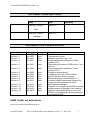
ASCAT Wind Product User Manual Ocean and Sea Ice SAF Global OSI SAF 25-km wind product (OSI-102 and OSI-102b) Global OSI SAF 12.5-km wind product (OSI-103) Global OSI SAF coastal wind product (OSI-104 and OSI-104b) Regional EARS 25-km wind product Regional EARS 12.5-km wind product Version 1.13 May 2013 SAF/OSI/CDOP/KNMI/TEC/MA/126 DOCUMENT SIGNATURE TABLE Prepared by : Name Date O&SI SAF Project May 2013 Signature Team Approved by : O&SI SAF Project May 2013 Manager DOCUMENTATION CHANGE RECORD Issue / Revision Version 0.1 Version 1.0 Version 1.1 Version 1.2 Date : Feb 2007 Mar 2007 Sep 2007 Oct 2007 Change : Minor Minor Minor Version 1.3 Oct 2007 Minor Version 1.4 Mar 2008 Minor Version 1.5 Version 1.6 Version 1.7 Version 1.8 Version 1.9 Nov 2008 Jan 2009 Aug 2009 Jan 2010 Feb 2011 Minor Minor Minor Minor Major Version 1.10 Version 1.11 Version 1.12 Version 1.13 Aug 2011 Feb 2012 Aug 2012 May 2013 Minor Minor Minor Major Description : Draft version First external version Added release note (sec. 1.4) Single transponder calibrated L1 data (version 5.2.1) Take some comments of ORR-A part 1 into account Three-transponder calibrated L1 data (version 5.5.0) Change to neutral winds Comments of 12.5-km DRI included NetCDF product format included Editorial changes, included section 1.7. Included coastal product and changes for merging of soil moisture and winds Some editorial changes Changes for timeliness and EARS coverage Implementation of Bayesian ice screening Removed information which is now in the ATBD; include Metop-B; include comments from Metop-B ORR KNMI, De Bilt, the Netherlands Reference: SAF/OSI/CDOP/KNMI/TEC/MA/126 OSI SAF/EARS ASCAT Wind Product User Manual version 1.13 May 2013 2 SAF/OSI/CDOP/KNMI/TEC/MA/126 Cover illustration: ASCAT winds over the Atlantic on 7 February 2007, around 21 hour UTC (red arrows). In this picture, only half of the ASCAT wind vectors, with 25-km cell spacing, are plotted. The blue and purple arrows show a 3-hour forecast of the winds by the KNMI High-Resolution Limited Area Model (HiRLAM). In the background, a METEOSAT infrared image is shown in black and white. OSI SAF/EARS ASCAT Wind Product User Manual version 1.13 May 2013 3 SAF/OSI/CDOP/KNMI/TEC/MA/126 Contents 1. Introduction.......................................................................................................................5 1.1. Overview...................................................................................................................5 1.2. Disclaimer .................................................................................................................6 1.3. References ...............................................................................................................6 1.4. Useful links ...............................................................................................................6 1.5. Limitations of the ASCAT winds ...............................................................................7 1.6. History of product changes .......................................................................................7 2. The ASCAT instrument.....................................................................................................9 3. Processing scheme ........................................................................................................10 3.1. Backscatter averaging ............................................................................................10 3.2. Backscatter calibration ...........................................................................................10 3.3. NWP collocation .....................................................................................................10 3.4. Quality control and monitoring ................................................................................11 4. Helpdesk, product dissemination and archive ................................................................12 5. Data description..............................................................................................................13 5.1. Wind product characteristics...................................................................................13 5.2. File formats .............................................................................................................14 6. Data quality.....................................................................................................................17 7. Glossary .........................................................................................................................19 8. ASCAT BUFR data descriptors ......................................................................................20 9. NetCDF data format .......................................................................................................22 OSI SAF/EARS ASCAT Wind Product User Manual version 1.13 May 2013 4 SAF/OSI/CDOP/KNMI/TEC/MA/126 1. Introduction 1.1. Overview The EUMETSAT Ocean and Sea Ice Satellite Application Facility (OSI SAF) produces a range of air-sea interface products, namely: wind, sea ice characteristics, Sea Surface Temperatures (SST) and radiative fluxes, Surface Solar Irradiance (SSI) and Downward Long wave Irradiance (DLI). KNMI is involved in the OSI SAF and the EUMETSAT Advanced Retransmission Service (EARS) ASCAT service as the centre where the Level 1b to Level 2 wind processing is carried out. This document is the Product User Manual to the ASCAT wind products. Quality monitoring information on this product and more general information on the whole OSI SAF project, is available on the OSI SAF web site: http://www.osi-saf.org/. The user is strongly encouraged to register on this web site in order to receive the service messages and the latest information about the OSI SAF products. The wind products are distributed in two resolutions: a 50-km resolution product with 25-km cell spacing and a 25-km resolution product with 12.5-km cell spacing. Both resolutions are available as a regional (mainly covering the Northern Hemisphere) EARS product with a timeliness of approximately 25 minutes from sensing time and as a global OSI SAF product with a timeliness of approximately 1.5-2 hours from sensing time. Moreover, a global OSI SAF coastal product is available with 12.5-km cell spacing. The wind characteristics in full sea regions are comparable to those of the nominal 12.5-km product but additionally more wind data closer to the coast are available. At the time of writing this manual, not all products are available (yet) for Metop-B. The scatterometer is an instrument that provides information on the wind field near the ocean surface, and scatterometry is the knowledge of extracting this information from the instrument’s output. Space-based scatterometry has become of great benefit to meteorology and climate in the past years. This is extensively described in the Algorithm Theoretical Basis Document; see [Ref-1]. KNMI has a long experience in scatterometer processing and is developing generic software for this purpose. Processing systems have been developed for the ERS, NSCAT, SeaWinds and ASCAT scatterometers. Scatterometer processing software is developed in the EUMETSAT Numerical Weather Prediction Satellite Application Facility (NWP SAF), whereas wind processing is performed operationally in the Ocean and Sea Ice SAF (OSI SAF) and in the EARS project. EUMETSAT makes available near real-time Level 1b scatterometer products from the Metop-A and -B satellites through EUMETCast (global data) and through a private network (regional data). These products are used as basis for further processing at KNMI. The OSI SAF and EARS products are delivered on request through the KNMI FTP server to all users and through the EUMETCast system. See also http://www.knmi.nl/scatterometer/ for real-time graphical examples of the products and up-to-date information and documentation. This user manual outlines user information for the OSI SAF and EARS products based on the ASCAT scatterometer. Section 2 presents a brief description of the ASCAT instrument and section 3 gives an overview of the data processing configuration. Section 4 provides details on how to access the products. Detailed information on the file content and format is given in section 5, while in section 6 the product quality is elaborated. This manual covers the following products: OSI SAF/EARS ASCAT Wind Product User Manual version 1.13 May 2013 5 SAF/OSI/CDOP/KNMI/TEC/MA/126 OSI SAF ASCAT 25-km wind product (OSI-102, acronym ASCAT25, for Metop-A and -B) OSI SAF ASCAT 12.5-km wind product (OSI-103, acronym ASCAT12), for Metop-A OSI SAF ASCAT 12.5-km coastal wind product (OSI-104, acronym ASCAT12+), for Metop-A and –B EARS ASCAT 25-km wind product (acronym EARS-ASCAT-25) , for Metop-A EARS ASCAT 12.5-km wind product (acronym EARS-ASCAT-12) , for Metop-A Products OSI-102 and OSI-103 also contain soil moisture information over land (OSI-102 both for Metop-A and –B), the coastal and EARS products do not contain soil moisture information. 1.2. Disclaimer All intellectual property rights of the OSI SAF and EARS products belong to EUMETSAT. The use of these products is granted to every interested user, free of charge. If you wish to use these products, EUMETSAT's copyright credit must be shown by displaying the words "copyright (year) EUMETSAT" on each of the products used. The OSI SAF and EUMETSAT are much interested in receiving your feedback, would appreciate your acknowledgment in using and publishing about the data, and like to receive a copy of any publication about the application of the data. Your feedback helps us in maintaining the resources for the OSI SAF wind services. 1.3. References [Ref-1] OSI SAF, Algorithm Theoretical Basis Document for the OSI SAF wind products, SAF/OSI/CDOP2/KNMI/SCI/MA/197 (*) [Ref-2] Verhoef, A., and A. Stoffelen, ASCAT coastal winds validation report, OSI SAF Report, SAF/OSI/CDOP/KNMI/TEC/RP/176, 2011 (*) [Ref-3] Verhoef, A., M. Portabella and A. Stoffelen, High-resolution ASCAT scatterometer winds near the coast, IEEE Transactions on Geoscience and Remote Sensing, 2012, 50, 7, 2481-2487, doi:10.1109/TGRS.2011.2175001 [Ref-4] Verspeek, J., M. Portabella, A. Stoffelen and A. Verhoef, ASCAT Calibration and Validation, OSI SAF Technical Report, SAF/OSI/CDOP/KNMI/TEC/TN/163 (*) [Ref-5] Verspeek, J., A. Verhoef and A. Stoffelen, ASCAT-B NWP Ocean Calibration and Validation, OSI SAF Technical Report, SAF/OSI/CDOP2/KNMI/TEC/RP/199, 2013 (*) [Ref-6] EUMETSAT, ASCAT Level 1 Product Generation Function Specification, EUM.EPS.SYS.SPE.990009 [Ref-7] Thesis “Scatterometry” by Ad Stoffelen, 1998 (*) [Ref-8] ADDITIONS TO BUFR/CREX TABLES FOR PRE-OPERATIONAL IMPLEMENTATION ENDORSED BY CBS for full operational status on 7 November 2007 (updated 04/01/07), pp55-60, available on http://www.wmo.int/web/www/WMOCodes/Updates/BUFRCREX/Preoperational050107.doc References marked with a (*) are available on http://www.knmi.nl/scatterometer/publications/. 1.4. Useful links KNMI scatterometer web site: http://www.knmi.nl/scatterometer/ - Information on OSI SAF activities at KNMI: http://www.knmi.nl/scatterometer/osisaf/ OSI SAF/EARS ASCAT Wind Product User Manual version 1.13 May 2013 6 SAF/OSI/CDOP/KNMI/TEC/MA/126 - Information on EARS activities at KNMI: http://www.knmi.nl/scatterometer/ears/ - ASCAT visual products: http://www.knmi.nl/scatterometer/ascat_osi_25_prod/, http://www.knmi.nl/scatterometer/ascat_osi_12_prod/, http://www.knmi.nl/scatterometer/ascat_osi_co_prod/, http://www.knmi.nl/scatterometer/ascat_ear_25_prod/, http://www.knmi.nl/scatterometer/ascat_ear_12_prod/, http://www.knmi.nl/scatterometer/ascat_b_osi_25_prod/, http://www.knmi.nl/scatterometer/ascat_b_osi_co_prod/ Information on EARS and EUMETCast: http://www.eumetsat.int/ O&SI SAF wind product documentation on http://www.osi-saf.org/: - Scientific documents - Technical documents NWP SAF website: http://www.nwpsaf.org/ EUMETSAT ASCAT documentation: http://www.eumetsat.int/Home/Main/Satellites/Metop/Instruments/SP_2010053161611647?l=en EUMETSAT ASCAT product guide: http://oiswww.eumetsat.org/WEBOPS/eps-pg/ASCAT/ASCAT-PG-index.htm 1.5. Limitations of the ASCAT winds The following restrictions and limitations hold: 1) Although the Level 1 product is fully calibrated now using three transponders on the ground, the backscatter values are corrected using a calibration table, derived from a geophysical wind model. The backscatter values in the Level 2 wind product are however plain copies of those in the Level 1 product. The corrections are very small and expected to be incorporated into a new version of the Geophysical Model Function. 2) The backscatter data and noise values (Kp) in the coastal product are computed as part of the level 2 wind processing and they are not scientifically validated, other than by validation of the wind retrieval properties in the coastal products. 3) The provision of the full resolution ASCAT backscatter product from EUMETSAT to KNMI, which is necessary for the coastal wind product processing, is not considered an operational process. Hence the coastal wind product can not have a fully operational status. These restrictions and limitations are subject to further study. 1.6. History of product changes Here is an historical overview of the changes in the ASCAT wind products: 28-Mar-2007 OSI SAF ASCAT 25-km demonstration wind product available EUMETCast. ASCAT Wind Data Processor software version is 1_0i. on 23-May-2007 Processing transferred to operational KNMI server. 10-Oct-2007 AWDP version 1_0k: adapted to the improved calibration of the Level 1 product. Wind product status is pre-operational now. 12-Dec-2007 AWDP version 1_0l: OSI SAF ASCAT 25-km winds are available on the GTS. 18-Mar-2008 AWDP version 1_0_13: adapted to the three-transponder calibration of the Level 1 product. OSI SAF/EARS ASCAT Wind Product User Manual version 1.13 May 2013 7 SAF/OSI/CDOP/KNMI/TEC/MA/126 20-Nov-2008 AWDP version 1_0_15: change to neutral winds (0.2 m/s added to the wind speeds) and improved calibration of the level 1 product (activated at 2 December). 03-Dec-2008 OSI SAF ASCAT 25-km wind product has the operational status. 11-Dec-2008 EARS ASCAT 25-km and 12.5-km winds are available to all users. 03-Mar-2009 OSI SAF ASCAT 12.5-km wind product is available with the operational status. 21-Apr-2009 AWDP version 1_0_17: upgrades in BUFR encoding. 01-Sep-2009 AWDP version 1_0_18: wind products are available in NetCDF now on the KNMI FTP server. 08-Sep-2009 EARS ASCAT data are available on the GTS. 12-Jan-2010 AWDP version 1_0_19: products in BUFR Edition 4 and up to four wind solutions present in 25-km BUFR products. 02-Feb-2010 OSI-SAF products disseminated on EUMETCast are also available to users in Africa and the Americas now. 28-Feb-2011 Both wind and soil moisture information are available in a multi-parameter BUFR product. 16-Aug-2011 AWDP version 2_1_00: up to four wind solutions present in the 12.5-km and coastal BUFR products, use of NWP Ocean Calibration for more uniform wind characteristics across the swath. 23-Aug-2011 AHRPT data from a number of ground stations are now available in addition to the EARS ASCAT data acquired at Svalbard. 18-Sep-2012 Implementation of Bayesian ice screening. 14-Nov-2012 First development version of ASCAT-B 25-km and coastal global wind products. AWDP version is 2_1_01. 14-May-2013 AWDP version 2_2_00: preparation for level 1b data format change. OSI SAF/EARS ASCAT Wind Product User Manual version 1.13 May 2013 8 SAF/OSI/CDOP/KNMI/TEC/MA/126 2. The ASCAT instrument The Advanced SCATterometer (ASCAT) is one of the instruments carried on-board the Meteorological Operational (Metop) polar satellites launched by the European Space Agency (ESA) and operated by the EUropean organisation for the exploitation of METeorological SATellites (EUMETSAT). Metop-A, the first in a series of three satellites, was launched on 19 October 2006, Metop-B was launched on 17 September 2012. Metop-C is planned to be launched approximately in 2017. ASCAT is a real aperture radar using vertically polarised antennas. It transmits a long pulse with Linear Frequency Modulation (‘chirp’). Ground echoes are received by the instrument and, after de-chirping, the backscattered signal is spectrally analysed and detected. In the power spectrum, frequency can be mapped into slant range provided the chirp rate and the Doppler frequency are known. The above processing is in effect a pulse compression, which provides range resolution. Two sets of three antennas are used to generate radar beams looking 45 degrees forward, sideways, and 45 degrees backwards with respect to the satellite's flight direction, on both sides of the satellite ground track. These beams illuminate approximately 550 km-wide swaths (separated by about 700 km) as the satellite moves along its orbit, and each provide measurements of radar backscatter from the sea surface on a 25 km or 12.5 km grid, i.e. each swath is divided into 21 or 41 so-called Wind Vector Cells (WVCs). This brings the effective swath width to 525 km (21x25) or 512.5 km (41x12.5) for the 25-km and 12.5-km products, respectively. For each WVC, we obtain three independent backscatter measurements using the three different viewing directions and separated by a short time delay. As the backscatter depends on the sea surface roughness as a function of the wind speed and direction at the ocean surface, it is possible to calculate the surface wind speed and direction by using these 'triplets' within a mathematical model. The instrument operates at a frequency of 5.255 GHz (C-band), which makes it rather insensitive to rain. Figure 1: ASCAT wind scatterometer geometry (source: EUMETSAT web site). OSI SAF/EARS ASCAT Wind Product User Manual version 1.13 May 2013 9 SAF/OSI/CDOP/KNMI/TEC/MA/126 3. Processing scheme KNMI has a processing chain running in near real-time with ASCAT data, including visualisation on the internet. This processor is based on the NWP SAF software and runs in the KNMI operational environment. The processing includes monitoring and archiving functionalities. A brief overview of the modules of the ASCAT scatterometer processor is given below. General information about the scatterometer wind processing algorithms can be found in the ATBD [Ref-1]. 3.1. Backscatter averaging In this step, which is performed only for the coastal product, the full resolution ASCAT level 1 product is used to re-compute backscatter values (σ 0s) in the Wind Vector Cells. The full resolution backscatter data are averaged using a spatial box filter rather than the Hamming filter that is used in the spatial averaging of the σ 0s of the nominal level 1 products. All full resolution σ 0s within 15 km from the Wind Vector Cell centre are used in the averaging [Ref-2]. Moreover, in Wind Vector Cells close to the coast, only those full resolution σ 0s are used that are entirely over sea. As the position of the averaged σ 0 is an averaged value of the positions of the full resolution σ 0s, the coastal Wind Vector Cell is slightly displaced away from the coast. On the other hand, it is possible to compute winds as close as ~15 km from the coast, while in the nominal 12.5-km product, Wind Vector Cells closer than ~35 km from the coast are flagged because of land contamination. See [Ref-2] and [Ref-3] for more information on the coastal product. 3.2. Backscatter calibration The backscatter values in the Level 1 product are calibrated by adding a WVC and beam dependent bias in dB to the incoming σ 0s. The calibration table was obtained by fitting the actual measurements to the theoretical GMF function. More details are provided in [Ref-4] and [Ref-5]. Note that the calibrated backscatter values are only available within the wind processing software; the σ 0 data in the wind product are identical to those in the Level 1 product. 3.3. NWP collocation KNMI receives NWP model data from ECMWF twice a day through the RMDCN. NWP model sea surface temperature (SST) data are used to support the Bayesian sea ice discrimination [Ref-1]. The SST values of the four surrounding model grid points around the WVC location are bilinearly interpolated. Note that the ECMWF model data do not contain SST values over land; if one or more of the four surrounding grid points has missing SST data, the SST value of the grid point closest to the WVC is taken. WVCs with a sea surface temperature above 5 °C are assumed to be always open water. The ice screening procedure may sometimes assign rainy WVCs erroneous as ice; using the extra SST criterion, WVCs in warmer areas will never be labelled as ice. Due to its rather high threshold value, the NWP SST ice screening will only be active in regions far away from the ice extents. Land presence within each WVC is determined by using the land-sea mask available from the model data. The weighted mean value of the land fractions of all model grid points within 80 km of the WVC centre is calculated. The weight of each grid point scales with 1/r2, where r is the distance between the WVC centre and the model grid point. If this mean land fraction value exceeds a threshold of 0.02, no wind retrieval is performed. Also the land fractions present in the beam information in the level 1b product are considered: if any land fraction in the fore, mid or aft beam exceeds 0.02, no wind retrieval is performed. OSI SAF/EARS ASCAT Wind Product User Manual version 1.13 May 2013 10 SAF/OSI/CDOP/KNMI/TEC/MA/126 NWP forecast wind data are necessary in the ambiguity removal step of the processing. Wind forecasts are available twice a day (00 and 12 GMT analysis time) with forecast time steps of +3h, +6h, …, +36h. The model wind data are linearly interpolated with respect to time and location and put into the level 2 information part of each WVC (see section 5.2). Note that the ECMWF winds stored in the wind products are real winds rather than neutral winds. 3.4. Quality control and monitoring In each WVC, the σ 0 data is checked for quality and completeness and the inversion residual (see [Ref-1]) is checked. Degraded WVCs are flagged; see section 5.2 for more details. An information file is made for each product. The content of the file is identical whatever the product and results from a compilation of all the global information concerning this product. From these files, various graphs are produced to visually display the confidence levels of the products and their evolution with time. These graphs are available in near-real time if you click on the ‘Monitoring information’ link on the product visualisation web pages. Data quality is also available to the users within the products; see section 5 and 6 for a description of quality flags. OSI SAF/EARS ASCAT Wind Product User Manual version 1.13 May 2013 11 SAF/OSI/CDOP/KNMI/TEC/MA/126 4. Helpdesk, product dissemination and archive For a swift response management procedure, user requests on the OSI SAF data products should be issued at the Ocean and Sea Ice SAF website (http://www.osi-saf.org/). User requests on the EARS products can be sent to [email protected]. User requests on the Soil Moisture content in the products can be sent to [email protected]. The ASCAT BUFR L2 products are disseminated on EUMETCast. Please consult http://www.eumetsat.int/, under ‘Access to Data’ for more information on EUMETCast dissemination and how to receive these and other EUMETSAT meteorological satellite products, or contact [email protected]. The BUFR and NetCDF products are also made available on a password-protected ftp site. This password is provided to new users by Email request. Please send your requests to [email protected]. The Metop-A ASCAT 25-km global winds in BUFR format are disseminated on the GTS. The messages are distributed to the Exeter node and can be identified by: header (T1T2A1A2ii) = ISXX[01-06]; CCCC = EHDB. The coastal winds are available on the GTS with identification header (T1T2A1A2ii) = ISXX[11-16]; CCCC = EHDB. The EARS Metop-A ASCAT winds are also available on the GTS with identification header (T1T2A1A2ii) = ISXN[01-06]; CCCC = EHDB (25-km) and header (T1T2A1A2ii) = ISXN[11-16]; CCCC = EHDB (12.5-km). A BUFR reader is available at www.knmi.nl/scatterometer/bufr_reader/. The OSI SAF Metop-A ASCAT data are archived in the EUMETSAT Data Centre Archive, see http://www.eumetsat.int/Home/Main/DataAccess/EUMETSATDataCentre/index.htm?l=en (BUFR and NetCDF). For data not (yet) present in the EUMETSAT Data Centre, KNMI also keeps an off line archive of the global products. You can send a request to [email protected]. The OSI SAF Metop-A ASCAT data in NetCDF are also archived in the NASA Physical Oceanography Distributed Active Archive Center (PO.DAAC) archive, see http://podaac.jpl.nasa.gov/datasetlist?ids=Sensor&values=ASCAT&search=. The ASCAT 25-km global winds can be explored through the Enhanced Satellite Archive Dataminer Naiad: http://www.naiad.fr/ OSI SAF/EARS ASCAT Wind Product User Manual version 1.13 May 2013 12 SAF/OSI/CDOP/KNMI/TEC/MA/126 5. Data description 5.1. Wind product characteristics Physical definition Horizontal equivalent neutral wind vector at 10 m height (see [Ref-1]). Units and range Wind speed is measured in m/s. The wind speed range is from 0-50 m/s, but wind speeds over 25 m/s are generally less reliable [Ref-1]. In the BUFR products, the wind direction is in meteorological (WMO) convention relative to North: 0 degrees corresponds to a wind flowing to the South with a clockwise increment. In the NetCDF products, the wind direction is in oceanographic convention: 0 degrees corresponds to a wind flowing to the North with a clockwise increment. Input satellite data The generation of ASCAT level 1b data by EUMETSAT is described in their technical documentation [Ref-6]. The global ASCAT data are acquired in Svalbard (Norway) and transmitted to the EUMETSAT central processing facilities in Darmstadt, where they are processed up to level 1b. Regional EARS data are acquired at Svalbard and other ground stations, processed up to level 1b and then transmitted to KNMI via a dedicated private network. The product contains geo-located measurement triplets on a satellite swath WVC grid of 25 km or 12.5 km size. Geographical definition The Metop satellite flies in a near-polar sun synchronous orbit at 98 degrees inclination at approximately 800 km orbit height. The two satellite swaths are located to the left and to the right of the satellite ground track. The swath width is either 21 25-km size WVCs, corresponding to 525 km or 41 12.5-km size WVCs, corresponding to 512.5 km. Products are organised in rows of 42 or 82 WVCs, respectively. Coverage The OSI SAF products have global coverage. For the ascending Metop-A tracks, the EARS data correspond to the last 30 minutes of the X-band data dump when the satellite passes the Svalbard ground station. For the descending tracks, also AHRPT data from several ground stations are used, adding coverage in the European seas and Atlantic and Indian oceans. An up-to-date list of ground stations in use is available on http://www.eumetsat.int/Home/Main/Satellites/GroundNetwork/EARSSystem/EARSASCAT/index.htm?l=en. Actual wind coverage is available on the OSI SAF and EARS ASCAT product visualisation websites (see http://www.knmi.nl/scatterometer/). Output product The input product in BUFR is processed into a BUFR output product including a unique wind solution (chosen), its corresponding ambiguous wind solutions and quality information (distance to cone, quality flag). The products contain up to four wind solutions. The products are also available in NetCDF format; see section 9 for more details. Delivery time A wind product is available for distribution within 10 minutes after the input product reception at KNMI. For the global product, the delivery time between acquisition of the data and availability for the user ranges from 40 to 120 minutes. The regional product is available within 25 minutes after data acquisition. Timeliness statistics are available on the product visualisation websites, after clicking on the ‘Monitoring information’ link. OSI SAF/EARS ASCAT Wind Product User Manual version 1.13 May 2013 13 SAF/OSI/CDOP/KNMI/TEC/MA/126 Expected accuracy The expected accuracy is defined as the expected bias and standard deviation of the primary calculations. The accuracy is validated against in situ wind measurements from buoys, platforms, or ship, and against NWP data. Even better, the errors of all NWP model winds, in situ data, and scatterometer winds are computed in a triple collocation exercise [Ref-7]. The performance is pretty constant over the globe and depends mainly on the sub footprint wind variability. The performance of the products issued by the OSI SAF and EARS is characterised by a wind component RMS error smaller than 2 m/s and a bias of less than 0.5 m/s in wind speed. 5.2. File formats Wind products are in BUFR Edition 4 or in NetCDF format. A complete description of BUFR can be found in WMO publication No 306, Manual on Codes. The graphical displays of the wind products are available and explained on the web: see the links on http://www.knmi.nl/scatterometer/. The file name convention for the Level 2 BUFR product is ascat_YYYYMMDD_HHMMSS_SAT_ORBIT_SRV_T_SMPL(_CONT).l2_bufr, where ascat denotes the instrument YYYYMMDD denotes the date of the first data in the file HHMMSS denotes the time (UTC) of the first data in the file SAT denotes the satellite name: metopa or metopb ORBIT is the orbit number (00000-99999) SRV is the service (eps for global OSI SAF or ear for regional EARS) T is the processing type (o for operational, t for test) SMPL is the WVC sampling (cell spacing): 250 or 125, or coa for the coastal product which has a WVC spacing of 12.5 km, as well. CONT (optional field) refers to the product contents: ovw for a product containing only Ocean Vector Winds and no soil moisture information, CONT is omitted if the product contains both winds and soil moisture. l2_bufr (l is the lowercase L) denotes Level 2 product in BUFR Examples of file names are ascat_20070213_021503_metopa_01653_eps_t_250.l2_bufr for a global test product containing soil moisture information, or ascat_20070213_021503_metopa_01653_ear_o_125_ovw.l2_bufr for a regional operational product containing no soil moisture information. The wind product is stored in the BUFR format as proposed for ASCAT and described in [Ref-8], a list of descriptors (fields) contained in each WVC is provided in section 8. The BUFR data contain three main sections: level 1 information (fields 1-62), level 2 Soil Moisture information (fields 63-82) and level 2 wind information (fields 83 and up). The L1 information is simply copied into the L2 data, except for the coastal product, where the backscatter data are recalculated based on the data in the ASCAT full resolution level 1 product [Ref-3]. More information on the L1 data can be found in the EUMETSAT ASCAT Product Guide, see the link in section 1.4. The Soil Moisture data are produced by and under the responsibility of the EUMETSAT central facilities. The coastal product does not contain Soil Moisture information since it contains recalculated backscatter information which is not OSI SAF/EARS ASCAT Wind Product User Manual version 1.13 May 2013 14 SAF/OSI/CDOP/KNMI/TEC/MA/126 input to the Soil Moisture computations. In this way, inconsistency between the backscatter data and Soil Moisture in one product is avoided. Field 2 (‘Identification of originating/generating sub-centre’) is set to 0 for OSI SAF products. For EARS products, a value of 1 refers to X-band data dumps from Svalbard, whereas other values refer to AHRPT ground stations. For a list of ground stations, see http://www.eumetsat.int/Home/Main/Satellites/GroundNetwork/EARSSystem/EARSASCAT/index.htm?l=en. Field 84 (‘Generating Application’) contains the value 91 which means that first guess model winds are used for ambiguity removal. The interpolated model winds are in the fields 85-86. The Wind Vector Cell Quality Flag (field 89, table 021155) has the following definitions: Description Not enough good sigma-0 available for wind retrieval Poor azimuth diversity among sigma-0 for wind retrieval Any beam noise content above threshold Product monitoring not used Product monitoring flag KNMI quality control fails Variational quality control fails Some portion of wind vector cell is over land Some portion of wind vector cell is over ice Wind inversion not successful for wind vector cell Reported wind speed is greater than 30 m/s Reported wind speed is less than or equal to 3 m/s Rain flag for the wind vector cell is not usable Rain flag algorithm detects rain No meteorological background used Data are redundant Distance to GMF too large Reserved Missing value BUFR bit 1 2 3 4 5 6 7 8 9 10 11 12 13 14 15 16 17 18-23 All 24 set Fortran bit 22 21 20 19 18 17 16 15 14 13 12 11 10 9 8 7 6 5-0 All 24 set In Fortran, if the Wind Vector Cell Quality is stored in an integer I then use BTEST(I,NDWNB-1) to test BUFR bit NB, where NDW=24 is the width in bits of the data element in BUFR. If the ‘monitoring not used’ bit (BUFR bit 4) is set to zero, the product is monitored. If the product is monitored and the ‘monitoring flag’ bit (BUFR bit 5) is set to zero, the product is valid; otherwise it is rejected by the monitoring, see [Ref-1]. The monitoring bits are set to the same value in all WVCs in one BUFR output file. If the KNMI QC flag (BUFR bit 6) is set in a WVC this means that the backscatter information is of poor quality for various reasons, such as a too large inversion residual, or a too high noise value in the input product. WVCs, in which the KNMI QC flag is set, are not used in the calculation of the analysis field in the ambiguity removal step. However, after the ambiguity removal the wind solution closest to the analysis field is chosen (if wind solutions are present in the WVC). This means that such a WVC may contain a selected wind solution, but it is suspect. Land presence flag is set if a land fraction (see section 3.3) larger than zero is calculated for the WVC. As long as the land fraction is below the limit value, a reliable wind solution may however still be present so there is normally no reason to reject WVCs with the land flag set. Ice presence flag is set if the Bayesian sea ice screening algorithm calculates ice for the WVC (see [Ref-1]). Note that the products contain wind solutions also over sea ice regions. These bogus winds are flagged both by the KNMI quality control flag and by the ice flag. OSI SAF/EARS ASCAT Wind Product User Manual version 1.13 May 2013 15 SAF/OSI/CDOP/KNMI/TEC/MA/126 Hence it is important that you reject any winds with the KNMI quality control flag set when ingesting the products. Note that WVCs that are rejected due to a large inversion residual (e.g., in case of rain), only have the KNMI quality control flag set. On the other hand, WVCs that are rejected due to sea ice, have both the KNMI quality control flag and the ice flag set. If the variational QC flag is set, the wind vector in the WVC is rejected during ambiguity removal due to spatial inconsistency. A wind solution is present, but it may be suspect. It is recommended not to use WVCs with the monitoring flag, the KNMI quality control flag or the variational quality control flag set. See [Ref-1] for more information on product reliability. The ‘likelihood computed for solution’ (descriptor 021104) actually contains the log10 of the calculated likelihood for the wind solution. This is done since otherwise values close to zero will be rounded to zero in the BUFR encoding. In order to recalculate the probability, the user should compute 10 to the power <value from BUFR>. OSI SAF/EARS ASCAT Wind Product User Manual version 1.13 May 2013 16 SAF/OSI/CDOP/KNMI/TEC/MA/126 6. Data quality As introduced in section 5.1, the accuracy should be better than 2 m/s in wind component RMS with a bias of less than 0.5 m/s in wind speed. Collocation result - speed (977034 wind vectors) Collocation result - direction (821351 wind vectors) 360 Scatterometer wind direction (deg) Scatterometer wind speed (m/s) 25 20 15 10 5 0 0 5 10 15 Model wind speed (m/s) 20 270 180 90 0 0 25 90 Collocation result - u (977140 wind vectors) Scatterometer v component (m/s) 10 0 -10 10 0 -10 -20 -20 -10 0 10 Model u component (m/s) 20 -20 -10 Histogram - speed 0 Model v component (m/s) 10 20 Histogram - direction Collocation result - direction (811903 wind vectors) Collocation result - speed (966770 wind vectors) 360 Scatterometer wind direction (deg) 25 Scatterometer wind speed (m/s) 360 20 -20 20 15 10 5 0 0 5 10 15 Model wind speed (m/s) 20 270 180 90 0 0 25 90 Collocation result - u (966859 wind vectors) 180 Model wind direction (deg) 270 360 Collocation result - v (966850 wind vectors) 20 Scatterometer v component (m/s) 20 Scatterometer u component (m/s) 270 Collocation result - v (977104 wind vectors) 20 Scatterometer u component (m/s) 180 Model wind direction (deg) Figure 2: Contoured histograms of the 25-km ASCAT wind product from Metop-A (top) and Metop-B (bottom) vs. ECMWF model forecast winds. 10 0 -10 -20 10 0 -10 -20 -20 -10 0 10 Model u component (m/s) Histogram - speed 20 -20 -10 0 Model v component (m/s) 10 20 Histogram - direction Figure 2 shows two-dimensional histograms of the retrieved winds versus ECMWF 10m wind background for the 25-km wind product, with the backscatter calibration (see section 3.2) applied. The data for these plots are from consecutive Metop-A and Metop-B orbits from 1 and 2 November 2012 (28 orbits from both satellites). The top left plots correspond to wind speed (bins of 0.5 m/s) and the top right plots to wind direction (bins of 2.5°). The latter are computed for ECMWF winds larger than 4 m/s. The bottom plots show the u and v wind component statistics (bins of 0.5 m/s). OSI SAF/EARS ASCAT Wind Product User Manual version 1.13 May 2013 17 SAF/OSI/CDOP/KNMI/TEC/MA/126 From these results, it is clear that the spread in the distributions is small. The wind speed biases are quite small, ~0.20 m/s. We obtain wind component standard deviations of 1.44 in u and 1.49 in v directions, both for Metop-A and Metop-B. Note that the data in the plots do not include WVCs that are quality controlled, i.e. have a too large inversion residual. Collocation result - speed (6256 wind vectors) Collocation result - direction (5531 wind vectors) 360 Scatterometer wind direction (deg) Scatterometer wind speed (m/s) 25 20 15 10 5 0 0 5 10 15 Buoy wind speed (m/s) 20 270 180 90 0 0 25 90 Collocation result - u (6257 wind vectors) Scatterometer v component (m/s) 10 0 -10 10 0 -10 -20 -20 -10 0 Buoy u component (m/s) 10 20 -20 -10 Histogram - speed 0 Buoy v component (m/s) 10 20 Histogram - direction Collocation result - direction (5559 wind vectors) Collocation result - speed (6278 wind vectors) 360 Scatterometer wind direction (deg) 25 Scatterometer wind speed (m/s) 360 20 -20 20 15 10 5 0 0 5 10 15 Buoy wind speed (m/s) 20 270 180 90 0 0 25 90 Collocation result - u (6280 wind vectors) 180 Buoy wind direction (deg) 270 360 Collocation result - v (6280 wind vectors) 20 Scatterometer v component (m/s) 20 Scatterometer u component (m/s) 270 Collocation result - v (6257 wind vectors) 20 Scatterometer u component (m/s) 180 Buoy wind direction (deg) Figure 3: Contoured histograms of the 25-km ASCAT wind product from Metop-A (top) and Metop-B (bottom) vs. in situ buoy winds. 10 0 -10 -20 10 0 -10 -20 -20 -10 0 Buoy u component (m/s) Histogram - speed 10 20 -20 -10 0 Buoy v component (m/s) 10 20 Histogram - direction Figure 3 shows the results of collocations of ASCAT winds from Metop-A and Metop-B with buoy winds. These results cover the period of November 2012 to January 2013 (3 months). For more details about the collocation method, please see [Ref-4] and [Ref-5]. We find a wind speed bias of -0.02 m/s for Metop-A and 0.05 m/s for Metop-B. Standard deviations of u and v wind components are 1.72 m/s and 1.76 m/s for Metop-A and 1.78 m/s and 1.80 m/s for Metop-B, respectively. These figures are all well within the OSI SAF requirements. More validation information can be found in [Ref-4] and [Ref-5]. OSI SAF/EARS ASCAT Wind Product User Manual version 1.13 May 2013 18 SAF/OSI/CDOP/KNMI/TEC/MA/126 7. Glossary AR Ambiguity Removal ASCAT Advanced Scatterometer BUFR Binary Universal Format Representation EARS EUMETSAT Advanced Retransmission Service EPS EUMETSAT Polar System ERS European Remote-Sensing Satellite EUMETCast EUMETSAT’s Digital Video Broadcast Data Distribution System EUMETSAT European Organisation for the Exploitation of Meteorological Satellites HDF Hierarchical Data Format JPL Jet Propulsion Laboratory (NASA) KNMI Royal Netherlands Meteorological Institute Metop Meteorological operational satellite NASA National Aeronautics and Space Administration (USA) NetCDF Network Common Data Form NOAA National Oceanic and Atmospheric Administration (USA) NSCAT NASA Scatterometer NWP Numerical Weather Prediction OSI SAF Ocean and Sea Ice SAF PO.DAAC Physical Oceanography Distributed Active Archive Center QC Quality Control QuikSCAT USA dedicated scatterometer mission RMDCN Regional Meteorological Data Communication Network SAF Satellite Application Facility SeaWinds Scatterometer on-board QuikSCAT platform (USA) SM Soil Moisture SOS Scatterometer Ocean Stress SST Sea Surface Temperature u West-to-east wind component v South-to-north wind component WVC Wind Vector Cell OSI SAF/EARS ASCAT Wind Product User Manual version 1.13 May 2013 19 SAF/OSI/CDOP/KNMI/TEC/MA/126 8. ASCAT BUFR data descriptors Number 1 2 3 4 5 6 7 8 9 10 11 12 13 14 15 16 17 18 19 20 21 22 23 24 25 26 27 28 29 30 31 32 33 34 35 36 37 38 39 40 41 42 43 44 45 46 47 48 49 50 51 Descriptor 001033 001034 025060 001007 002019 001012 004001 004002 004003 004004 004005 004006 005001 006001 005033 005040 006034 010095 021157 021150 008085 002111 002134 021062 021063 021158 021159 021160 021161 021162 021163 021164 021165 021166 008085 002111 002134 021062 021063 021158 021159 021160 021161 021162 021163 021164 021165 021166 008085 002111 002134 OSI SAF/EARS Parameter Identification Of Originating/Generating Centre Identification Of Originating/Generating Sub-Centre Software Identification Satellite Identifier Satellite Instruments Direction Of Motion Of Moving Observing Platform Year Month Day Hour Minute Second Latitude (High Accuracy) Longitude (High Accuracy) Pixel Size On Horizontal-1 Orbit Number Cross Track Cell Number Height Of Atmosphere Used Loss Per Unit Length Of Atmosphere Used Beam Collocation Beam Identifier Radar Incidence Angle Antenna Beam Azimuth Backscatter Radiometric Resolution (Noise Value) ASCAT Kp Estimate Quality ASCAT Sigma-0 Usability ASCAT Use Of Synthetic Data ASCAT Synthetic Data Quality ASCAT Satellite Orbit And Attitude Quality ASCAT Solar Array Reflection Contamination ASCAT Telemetry Presence And Quality ASCAT Extrapolated Reference Function ASCAT Land Fraction Beam Identifier Radar Incidence Angle Antenna Beam Azimuth Backscatter Radiometric Resolution (Noise Value) ASCAT Kp Estimate Quality ASCAT Sigma-0 Usability ASCAT Use Of Synthetic Data ASCAT Synthetic Data Quality ASCAT Satellite Orbit And Attitude Quality ASCAT Solar Array Reflection Contamination ASCAT Telemetry Presence And Quality ASCAT Extrapolated Reference Function ASCAT Land Fraction Beam Identifier Radar Incidence Angle Antenna Beam Azimuth Unit Code Table Code Table Numeric Code Table Code Table Degree True Year Month Day Hour Minute Second Degree Degree m Numeric Numeric m dB/m Flag Table Code Table Degree Degree dB % Code Table Code Table Numeric Numeric Numeric Numeric Numeric Numeric Numeric Code Table Degree Degree dB % Code Table Code Table Numeric Numeric Numeric Numeric Numeric Numeric Numeric Code Table Degree Degree ASCAT Wind Product User Manual version 1.13 May 2013 20 SAF/OSI/CDOP/KNMI/TEC/MA/126 Number 52 53 54 55 56 57 58 59 60 61 62 63 64 65 66 67 68 69 70 71 72 73 74 75 76 77 78 79 80 81 82 83 84 85 86 87 88 89 90 91 92 93 94 95 96 97 98 99 100 Descriptor 021062 021063 021158 021159 021160 021161 021162 021163 021164 021165 021166 025060 025062 040001 040002 021062 021151 021152 021153 021154 021062 021088 040003 040004 040005 040006 040007 020065 040008 040009 040010 025060 001032 011082 011081 020095 020096 021155 021101 021102 031001 011012 011011 021156 021104 011012 011011 021156 021104 Parameter Backscatter Radiometric Resolution (Noise Value) ASCAT Kp Estimate Quality ASCAT Sigma-0 Usability ASCAT Use Of Synthetic Data ASCAT Synthetic Data Quality ASCAT Satellite Orbit And Attitude Quality ASCAT Solar Array Reflection Contamination ASCAT Telemetry Presence And Quality ASCAT Extrapolated Reference Function ASCAT Land Fraction Software Identification Database Identification Surface Soil Moisture (Ms) Estimated Error In Surface Soil Moisture Backscatter Estimated Error In Sigma0 At 40 Deg Incidence Angle Slope At 40 Deg Incidence Angle Estimated Error In Slope At 40 Deg Incidence Angle Soil Moisture Sensitivity Backscatter Wet Backscatter Mean Surface Soil Moisture Rain Fall Detection Soil Moisture Correction Flag Soil Moisture Processing Flag Soil Moisture Quality Snow Cover Frozen Land Surface Fraction Inundation And Wetland Fraction Topographic Complexity Software Identification Generating Application Model Wind Speed At 10 m Model Wind Direction At 10 m Ice Probability Ice Age (A-Parameter) Wind Vector Cell Quality Number Of Vector Ambiguities Index Of Selected Wind Vector Delayed Descriptor Replication Factor Wind Speed At 10 m Wind Direction At 10 m Backscatter Distance Likelihood Computed For Solution Wind Speed At 10 m Wind Direction At 10 m Backscatter Distance Likelihood Computed For Solution Unit dB % Code Table Code Table Numeric Numeric Numeric Numeric Numeric Numeric Numeric Numeric Numeric % % dB dB dB/Degree dB/Degree dB dB dB Numeric Numeric Flag Table Flag Table % % % % % Numeric Code Table m/s Degree True Numeric dB Flag Table Numeric Numeric Numeric m/s Degree True Numeric Numeric m/s Degree True Numeric Numeric Note that descriptor numbers 93-96 can be repeated 1 to 144 times, depending on the value of the Delayed Descriptor Replication Factor (descriptor number 92) OSI SAF/EARS ASCAT Wind Product User Manual version 1.13 May 2013 21 SAF/OSI/CDOP/KNMI/TEC/MA/126 9. NetCDF data format The ASCAT wind products are also available in the NetCDF format, with the following characteristics: The data are organised in full orbits rather than in 3-minute granules. The data format meets the NetCDF Climate and Forecast Metadata Convention version 1.4 (http://cf-pcmdi.llnl.gov/). The data contain, contrary to the BUFR data, only Level 2 wind and sea ice information, no sigma0 nor soil moisture information. The aim was to create a compact and easy to handle product for oceanographic and climatological users. The data contain only the selected wind solutions, no ambiguity information. The wind directions are in oceanographic rather than meteorological convention (see section 5.1) The format is usable for ASCAT, ERS, QuikSCAT and any other scatterometer data. The data has file sizes comparable to those of the corresponding BUFR data (e.g., one orbit of ASCAT 25-km wind data is 2.6 MB in BUFR and 2.2 MB in NetCDF). When compressed with gzip, the size of one orbit in NetCDF reduces to ~820 kB. The NetCDF data in near real-time are only available on the KNMI FTP server, but EUMETCast dissemination can be considered on user request. The file name convention for the gzipped NetCDF product is ascat_YYYYMMDD_HHMMSS_SAT_ORBIT_SRV_T_SMPL_VERS(_CONT).l2.nc.gz where the meaning of the fields is identical to those in the BUFR file names (see section 5.2). Note that in NetCDF the SRV is always “eps” (global data) and the CONT is always “ovw” (Ocean Vector Winds). The VERS part of the file name denotes the software version. A file name example is: ascat_20090826_051502_metopa_14797_eps_o_250_1018_ovw.l2.nc.gz Below are some meta data contained in the NetCDF data files: dimensions: NUMROWS = 1581 ; NUMCELLS = 42 ; variables: int time(NUMROWS, NUMCELLS) ; time:long_name = "time" ; time:units = "seconds since 1990-01-01 00:00:00" ; int lat(NUMROWS, NUMCELLS) ; lat:long_name = "latitude" ; lat:units = "degrees_north" ; int lon(NUMROWS, NUMCELLS) ; lon:long_name = "longitude" ; lon:units = "degrees_east" ; short wvc_index(NUMROWS, NUMCELLS) ; wvc_index:long_name = "cross track wind vector cell number" ; wvc_index:units = "1" ; short model_speed(NUMROWS, NUMCELLS) ; model_speed:long_name = "model wind speed at 10 m" ; model_speed:units = "m s-1" ; short model_dir(NUMROWS, NUMCELLS) ; model_dir:long_name = "model wind direction at 10 m" ; model_dir:units = "degree" ; short ice_prob(NUMROWS, NUMCELLS) ; ice_prob:long_name = "ice probability" ; OSI SAF/EARS ASCAT Wind Product User Manual version 1.13 May 2013 22 SAF/OSI/CDOP/KNMI/TEC/MA/126 ice_prob:units = "1" ; short ice_age(NUMROWS, NUMCELLS) ; ice_age:long_name = "ice age (a-parameter)" ; ice_age:units = "dB" ; int wvc_quality_flag(NUMROWS, NUMCELLS) ; wvc_quality_flag:long_name = "wind vector cell quality" ; wvc_quality_flag:flag_masks = 64, 128, 256, 512, 1024, 2048, 4096, 8192, 16384, 32768, 65536, 131072, 262144, 524288, 1048576, 2097152, 4194304 ; wvc_quality_flag:flag_meanings = "distance_to_gmf_too_large data_are_redundant no_meteorological_background_used rain_detected rain_flag_not_usable small_wind_less_than_or_equal_to_3_m_s large_wind_greater_than_30_m_s wind_inversion_not_successful some_portion_of_wvc_is_over_ice some_portion_of_wvc_is_over_land variational_quality_control_fails knmi_quality_control_fails product_monitoring_event_flag product_monitoring_not_used any_beam_noise_content_above_threshold poor_azimuth_diversity not_enough_good_sigma0_for_wind_retrieval" ; short wind_speed(NUMROWS, NUMCELLS) ; wind_speed:long_name = "wind speed at 10 m" ; wind_speed:units = "m s-1" ; short wind_dir(NUMROWS, NUMCELLS) ; wind_dir:long_name = "wind direction at 10 m" ; wind_dir:units = "degree" ; short bs_distance(NUMROWS, NUMCELLS) ; bs_distance:long_name = "backscatter distance" ; bs_distance:units = "1" ; // global attributes: :title = "MetOp-A ASCAT Level 2 25.0 km Ocean Surface Wind Vector Product" ; :title_short_name = "ASCAT-L2-25km" ; :Conventions = "CF-1.4" ; :institution = "EUMETSAT/OSI SAF/KNMI" ; :source = "MetOp-A ASCAT" ; :software_identification_level_1 = 702 ; :instrument_calibration_version = 0 ; :software_identification_wind = 1018 ; :pixel_size_on_horizontal = "25.0 km" ; :service_type = "eps" ; :processing_type = "O" ; :contents = "ovw" ; :granule_name = "ascat_20090826_051502_metopa_14797_eps_o_250_1018_ovw.l2.nc" ; :processing_level = "L2" ; :orbit_number = 14797 ; :start_date = "2009-08-26" ; :start_time = "05:15:02" ; :stop_date = "2009-08-26" ; :stop_time = "06:53:56" ; :equator_crossing_longitude = " 244.606" ; :equator_crossing_date = "2009-08-26" ; :equator_crossing_time = "05:12:26" ; :rev_orbit_period = "6081.7" ; :orbit_inclination = "98.7" ; :history = "N/A" ; :references = "ASCAT Wind Product User Manual, http://www.osi-saf.org/, http://www.knmi.nl/scatterometer/" ; :comment = "Orbit period and inclination are constant values. All wind directions in oceanographic convention (0 deg. flowing North)" ; :creation_date = "2009-08-26" ; :creation_time = "08:31:31" ; OSI SAF/EARS ASCAT Wind Product User Manual version 1.13 May 2013 23