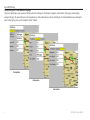
1
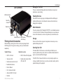
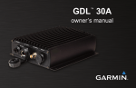
GDL 30/30A
owner’s manual
© 2005, 2008 Garmin Ltd. or its subsidiaries
Garmin International, Inc.
1200 East 151st Street,
Olathe, Kansas 66062, USA
Tel. (913) 397.8200 or (800) 800.1020
Fax (913) 397.8282
Garmin (Europe) Ltd.
Liberty House
Hounsdown Business Park,
Southampton, Hampshire, SO40 9RB UK
Tel. +44 (0) 870.8501241 (outside the UK)
0808 2380000 (within the UK)
Fax +44 (0) 870.8501251
Garmin Corporation
No. 68, Jangshu 2nd Road,
Shijr, Taipei County, Taiwan
Tel. 886/2.2642.9199
Fax 886/2.2642.9099
All rights reserved. Except as expressly provided herein, no part of this manual may be reproduced, copied, transmitted, disseminated, downloaded or stored in any storage medium, for any purpose without
the express prior written consent of Garmin. Garmin hereby grants permission to download a single copy of this manual onto a hard drive or other electronic storage medium to be viewed and to print one
copy of this manual or of any revision hereto, provided that such electronic or printed copy of this manual must contain the complete text of this copyright notice and provided further that any unauthorized
commercial distribution of this manual or any revision hereto is strictly prohibited.
Information in this document is subject to change without notice. Garmin reserves the right to change or improve its products and to make changes in the content without obligation to notify any person or
organization of such changes or improvements. Visit the Garmin Web site (www.garmin.com) for current updates and supplemental information concerning the use and operation of this and other Garmin
products.
Garmin® is a trademark of Garmin Ltd. or its subsidiaries, registered in the USA and other countries. GPSMAP® and myGarmin™ are trademarks of Garmin Ltd. or its subsidiaries. These trademarks may
not be used without the express permission of Garmin.
March 2008
Part Number 190-00336-00 Rev F
Printed in Taiwan
Introduction
The GDL 30/30A Marine Weather/Audio Satellite Receiver provides graphical
and textual marine XM WX weather information to be viewed on your Garmin
Marine Network chartplotters. Operation of the GDL 30 requires a subscription to
the XM WX Satellite Weather service. Additionally, the GDL 30A offers music,
news, and talk programming capability with a subscription to the XM Radio
service.
This manual covers the XM weather and audio features of the GDL 30/30A when
viewed on a GPSMAP 3000 Series Garmin Marine Network chartplotter. To
understand the XM weather and audio features of the GDL 30/30A when viewed
on a GPSMAP 4000 or 5000 series chartplotter, see the 4000 or 5000 series
Owner's Manual.
Important Numbers
Introduction
For future reference, write down the important numbers associated with your
GDL 30/30A.
Serial number
(located on the bottom of the unit)
Unique XM IDs are associated with your GDL 30/30A. XM Satellite Radio uses
these ID numbers to activate and deactivate your XM weather and XM audio (if
applicable). To locate the ID number(s) on your unit, see page 23.
XM WX Weather ID
To install the GDL 30/30A, reference the printed installation instructions.
Product terminology used throughout this manual
• This manual refers to the GDL 30 Marine Weather Satellite Receiver as
GDL 30 and the GDL 30A Marine Weather/Audio Satellite Receiver as
GDL 30A. It covers instructions for both units (GDL 30/30A). Unless
otherwise specified, unit operations are the same on both models.
• Garmin Marine Network Chartplotters are Multi-Function Display units
such as the GPSMAP 3005C, and GPSMAP 3006C/3010C. They are
referred to as chartplotters throughout this manual.
Product Registration
Help us better support you by completing our online registration today! Connect
to our Web site at http://my.garmin.com. Keep the original sales receipt, or a
photocopy, in a safe place.
GDL 30/30A Owner’s Manual
XM Radio ID
(GDL 30A only)
Contact Garmin
Contact Garmin if you have any questions while using your GDL 30/30A. In the
USA contact Garmin Product Support by phone: (913) 397-8200 or (800) 800-1020,
Monday–Friday, 8 AM–5 PM Central Time; or go to www.garmin.com/support/.
Contact XM
To set up your XM account call (800) 800-9200. For XM weather information,
visit www.xmwxweather.com.
Introduction
Introduction............................................................................i
Product terminology used throughout this manual . ........................ i
Product Registration................................................................. i
Important Numbers................................................................... i
Serial number.................................................................................... i
XM WX Weather ID......................................................................... i
XM Radio ID.................................................................................... i
Contact Garmin......................................................................... i
Contact XM................................................................................. i
Unit Overview.......................................................................1
Packing List and Accessories................................................. 1
Caring for the Unit.................................................................... 1
Cleaning the Case............................................................................ 1
Water Immersion............................................................................. 1
Storage............................................................................................. 1
Servicing Your Unit......................................................................... 1
Installing and Activating the Unit........................................2
Using XM WX Weather.........................................................3
Preset Weather Displays......................................................... 3
Selecting a preset weather display................................................... 3
To select a preset weather display: ................................................. 3
Customizing the Preset Weather Displays....................................... 4
The Weather Features..........................................................5
Precipitation.............................................................................. 5
NEXRAD......................................................................................... 5
Cloud Tops....................................................................................... 6
Cells................................................................................................. 7
Lightning......................................................................................... 8
Hurricanes........................................................................................ 9
Atmosphere............................................................................ 10
Wind.............................................................................................. 10
Pressure.......................................................................................... 11
Visibility........................................................................................ 12
Fronts............................................................................................. 13
Sea Surface............................................................................. 15
Temperature................................................................................... 15
Wave Height.................................................................................. 15
Wave Period................................................................................... 16
Wave Direction.............................................................................. 16
Main Menu...........................................................................17
Weather Tab............................................................................ 17
Current........................................................................................... 17
Forecast.......................................................................................... 18
Sea Surface.................................................................................... 19
Forecast Map................................................................................. 20
Setup.............................................................................................. 21
XM Tab..................................................................................... 22
Information.................................................................................... 23
Appendix.............................................................................24
Blink Codes............................................................................. 24
Weather-Related Broadcast Rates........................................ 24
GDL 30/30A Specifications.................................................... 25
GA 31 Antenna Specifications....................................................... 25
Product Safety and Regulatory Information........................ 26
Weather and Sea Surface information................................. 26
Caution.................................................................................... 26
Software.................................................................................. 27
Software Versions.......................................................................... 27
Limited Warranty.................................................................... 28
Index....................................................................................29
Unit Overview
Caring for the Unit
The case is constructed of high-quality materials and does not require user
maintenance, except cleaning.
LED Status Indicator
Cleaning the Case
Clean the unit’s outer casing using a cloth dampened with a mild detergent
solution and then wipe dry. Avoid chemical cleaners and solvents that may
damage plastic components.
Power/Data
Connector
Weather Cap
Water Immersion
Network Port
Antenna Connector Audio Connector
(GDL 30A only)
Mounting Holes
Packing List and Accessories
Before installing your unit, please check to see that your package includes
the following items. If any parts are missing, contact your Garmin dealer
immediately.
Standard Package
•
•
•
•
•
•
•
•
Unit Overview
GDL 30 or 30A unit
7-pin power cable
Garmin marine network cable (6 ft)
Installation Instructions
Owner’s Manual
GA 31 Antenna with cable
Audio cable (GDL 30A only)
Grommet
GDL 30/30A Owner’s Manual
Optional Accessories
• GMS 10 Network Port Expander
• Garmin marine network cables
(20 ft and 40 ft)
The unit is waterproof to IEC Standard 60529 IPX7. It can withstand immersion
in 1 meter of water for 30 minutes. Prolonged submersion can cause damage to
the unit. After submersion, be certain to wipe and air dry the unit before reuse.
Storage
Do not store the unit where exposure to temperature extremes may occur, as
permanent damage may result.
Servicing Your Unit
The Garmin GDL 30/30A has no user-serviceable parts. Should you ever
encounter a problem with your unit, take it to an authorized Garmin dealer for
repairs or contact Garmin Product Support.
The GDL 30/30A is fastened shut with screws. Any attempt to open the case
to change or modify the unit in any way voids your warranty and may result in
permanent damage to the equipment.
Installing and Activating the GDL 30/30A
Installing and Activating the GDL 30/30A
Step 1: Install the unit
Use the GDL 30/30A Installation Instructions to make the appropriate wiring
connections.
Step 2: Set up the XM account
Have your XM Weather ID ready (and XM Radio ID, if applicable). Contact
XM Satellite Radio by phone at 800-985-9200. After providing the required
information, the XM representative activates the account and sends out an
XM signal to activate the GDL 30/30A.
For answers to other XM questions, call the above number or visit www.xmwxweather.com.
Step 4: Save the service package
After the service package name appears, turn off the entire marine network
using the chartplotter’s power key.
Step 5: Use your new XM services
When you turn on the GDL 30/30A after completing Step 4, you are ready
to view weather features on the chartplotter and customize the new radio
stations (GDL 30A only).
Step 3: Confirm all components of your service package
XM WX Weather: Ensure your chartplotter turned on so you receive the
XM signal. The XM signal is received when the components of the selected
service package appear in the Weather Products list. Do not turn off the
chartplotter until the name of the selected service package appears in the
Service Level field (see page 23).
Note: on a 4000 or 5000 series chartplotter, your service package
appears on the system information screen (Configure > System > System
Information > Weather Subscription)
XM Radio: Highlight the Audio sub tab and verify that channels 7, 9, 47,
and 122 are being received (see page 22). This indicates that all channels
on XM’s basic radio service are being received. If within an hour the XM
WX Weather and/or the XM Radio service has not activated, call XM
customer care at 800-985-9200 to refresh the signal.
GDL 30/30A Owner’s Manual
Using XM WX Weather
Using XM WX Weather
This manual describes the use of XM WX Weather and XM Audio functions (GDL 30A only) on a GPSMAP 3000 Series chartplotter. If you have a GPSMAP 4000 or
5000 Series chartplotter, please use your chartplotter's Owner's Manual for instructions on using XM WX Weather and XM Audio.
Preset Weather Displays
Selecting a preset weather display
There are three preset weather displays, General, Sea State, and Storms. The name of the selected preset appears in the lower left corner of the screen. Use presets to
view different types of weather information quickly.
To select a preset weather display:
1. Press the Wthr Options soft key.
2. Press the Next Preset soft key to cycle through the three presets.
General
Sea State
Storms
GDL 30/30A Owner’s Manual
Using XM WX Weather
Customizing the Preset Weather Displays
The preset weather displays can be customized. Each preset has three subcategories: Precipitation, Atmosphere, and Sea Surface. Each category contains display
settings for that topic. The name of the preset can be changed and any of the weather features can be selected for display. For detailed information on customizing the
preset weather displays, please see the chartplotter’s Owner’s Manual.
Precipitation
Atmosphere
Sea Surface
GDL 30/30A Owner’s Manual
The Weather Features
The Weather Features
Following is a brief description of each weather feature. The weather features are divided into three sub categories, Precipitation, Atmosphere, and Sea State.
Precipitation
The Precipitation category contains NEXRAD/Cloud Tops, Storm Cells, Lightning, and Hurricanes. Each feature can be turned on, off, or set to display at a selected
zoom range.
NEXRAD
NEXRAD is an acronym for NEXt Generation Weather RADar. The NEXRAD feature displays precipitation from very light rain and snow up to strong thunderstorms in varying
shades and colors. A legend showing the colors for Rain, Mix, and Snow can be displayed by pressing the ADJ key and selecting Weather Legend. NEXRAD can be
displayed independently or with Cloud Tops.
NEXRAD
NEXRAD Legend
GDL 30/30A Owner’s Manual
The Weather Features
Cloud Tops
Cloud Tops displays the varying level of cloud tops in shades of gray. Cloud Tops can be displayed independently or with NEXRAD information.
Cloud Tops Legend
Cloud Tops
Cloud Tops with NEXRAD
GDL 30/30A Owner’s Manual
Storm Cells
The Weather Features
The Storm Cells feature displays storms as well as the storm’s projected path in the immediate future. It also shows the size of the storm cell. The direction of the red
cone indicates the projected path of the storm cell. The red bars that appear in the middle of the cone indicate where the storm will be in the future. Each bar represents
15 minutes.
The red bars that appear in the middle of the cone in this
storm indicate where the storm will be in the next hour.
GDL 30/30A Owner’s Manual
The Weather Features
Lightning
Lightning strikes are represented by lightning bolt icons, as shown in the images below. Lightning appears on the map if strikes have been detected within the last seven
minutes.
GDL 30/30A Owner’s Manual
Hurricanes
The Weather Features
The Hurricanes feature shows the current position of a hurricane as well as its projected path (indicated by a red line). The darkened squares that appear (as in the
examples in the left-hand column below) along the red line display the projected locations received from the National Hurricane Center. The Center provides four
forecasts at 12-hour intervals as well as a fifth forecast at a 24-hour interval.
In this example, this hurricane is projected to travel WestSouthwest before moving in a Northwesterly direction.
In this example of Hurricane Charley in August, 2004, NEXRAD data, wave height, and wind are shown.
This example shows Hurricane Charley’s projected
path through Florida in August 2004. Wind and storm
cells are also visible.
GDL 30/30A Owner’s Manual
The Weather Features
Atmosphere
The Atmosphere category contains Wind, Pressure, Visibility, Fronts and City Conditions. Each feature can be turned on, off, or set to appear at a selected zoom range.
Wind
The Wind feature displays wind speed and direction. Wind direction is indicated by a circle with a wind barb. The circle points into the wind with the barb as a tail.
Wind speed is indicated by different flags attached to the barb.
Wind Direction
Calm
5 knots
10 knots
15 knots
20 knots
50 knots
20-knot winds blowing to the Southwest.
10
GDL 30/30A Owner’s Manual
The Weather Features
Pressure
This feature displays pressure isobars and pressure centers on the chartplotter’s map. The isobars connect points of equal pressure. Pressure readings can help determine
weather and wind conditions in an area. High pressure areas are generally associated with fair weather. Low pressure areas are generally associated with clouds and the
chance of precipitation. Isobars that are packed closely together show a strong pressure gradient. Strong pressure gradients are associated with areas of stronger winds.
Pressure units can be displayed in Millibars (mb), Inches of Mercury (in), and Hectopascals (hPa). See the chartplotter’s Owner’s Manual for more information.
Pressure Isobars
Strong Pressure Gradient
GDL 30/30A Owner’s Manual11
The Weather Features
Visibility
Visibility is the maximum horizontal distance that can be seen. Isobars on the Visibility feature show a change in visibility. In the example below, visibility ranges from
.5 miles to 3 miles.
This image shows NEXRAD, Cloud Tops, and Visibility. Displaying
multiple features may help to provide a clearer picture of the weather
conditions in the area.
12
GDL 30/30A Owner’s Manual
The Weather Features
Fronts
The Fronts feature displays the lines indicating the leading edge of an air mass that is replacing another. This feature also displays pressure centers. Pressure centers are
represented by a large Red “L” for low pressure centers or a large Blue “H” for high pressure centers. Pressure centers represent an area where pressure is measured to
be either the highest or lowest relative to the surrounding area.
Cold Front
Warm Front
Stationary Front
Occluded Front
Dry Line
Indicates a Low Pressure Center. A Low
Pressure Center is an area where the
measured pressure is lowest relative to the
surrounding area. Moving away from a Low
Pressure Center in any horizontal direction
results in increased pressure. Winds flow
counterclockwise around Low Pressure
Centers in North America.
Indicates a High Pressure Center. Similar
to a Low Pressure Center, a High Pressure
Center is an area where the measured pressure
is highest relative to the surrounding area.
Moving away from a High Pressure Center in
any horizontal direction results in decreased
pressure. Winds flow clockwise around High
Pressure Centers in North America.
GDL 30/30A Owner’s Manual13
The Weather Features
City Conditions
This feature displays the current weather conditions at selected cities throughout North America. The current weather condition for an area is depicted by an icon.
City Condition Icons
Sunny
City Conditions
Partly Cloudy
Cloudy
Thunderstorms
Rain
Snow
Windy
Smoke
Foggy
14
GDL 30/30A Owner’s Manual
The Weather Features
Sea Surface
The Sea Surface category contains Temperature, Wave Height, Wave Period, and Wave Direction. Each feature can be turned on, off, or set to display at a selected zoom
range.
Temperature
The Temperature feature displays the water’s surface temperature. The temperature breaks are indicated by isobars.
Wave Height
The Wave Height feature displays wave heights. The wave heights for an area are separated by isobars.
Temperature feature
Wave Height feature
GDL 30/30A Owner’s Manual15
The Weather Features
Wave Period
The Wave Period feature provides the time (in seconds) between successive waves.
Wave Direction
The Wave Direction feature shows the direction in which a wave is moving, as indicated by the direction of the red arrow.
Wave Period feature
16
Wave Direction feature
GDL 30/30A Owner’s Manual
Main Menu
Main Menu
Weather Tab
The GDL 30/30A provides current weather conditions, forecast information, and sea surface information from the weather center nearest to your present location or a
location selected using the Find Information Page. To display the Weather tab, press and hold the ADJ/MENU key to display the Menu Menu. Using the ROCKER,
highlight the Weather tab. Five sub tabs are available: Current, Forecast, Sea Surface, Forecast Map, and Setup.
Current
The Current sub tab displays current weather conditions observed at the weather data location closest to your current position or a location selected using the Find
Information Page.
If a condition field is empty, data for that field is not available at this time.
To search for data at a location other than your current location, highlight
Current Position and press ENTER. With the Find Weather Information
Page displayed, highlight a search option and press ENTER. With a new
location selected, all information shown in the sub tab categories relates to
the selected location.
GDL 30/30A Owner’s Manual17
Main Menu
Forecast
The Forecast sub tab includes two panels that display forecast information for the location selected in the Current sub tab. The top panel displays the high/low
temperature, chance of precipitation, and weather condition (cloudy, sunny, thunderstorms). The number of days that appear in this panel depend on the data available
from the responding weather service center. If more than four days of forecasts appear, use the ROCKER to move down the list.
The bottom panel on the Forecast sub tab features a detailed 24-hour forecast for winds, wind gust, and visibility. In order to see all of this information, use the
ROCKER key to move down the list. If a condition field is empty, data for that field is not currently available.
The scroll bars indicate that additional information is available. To scroll through the
information, highlight the list.
18
GDL 30/30A Owner’s Manual
Sea Surface
Main Menu
The Sea Surface sub tab provides weather data of specific importance to mariners. This data comes from a variety of data sources that are nearest to your current or
selected location. If a condition field is empty, data for that condition is not currently available.
GDL 30/30A Owner’s Manual19
Main Menu
Forecast Map
The Forecast Map sub tab displays Fronts, High and Low Pressure Centers, and City Conditions. The map zoom range can be changed using the Range keys. There are
three icons at the top of the map. These icons are used to show or play the forecast conditions for the next 48 hours.
Backup
20
Play/Pause
Forward
GDL 30/30A Owner’s Manual
Setup
Main Menu
The Setup sub tab provides access to the three preset weather displays: General, Sea State, and Storms. The preset weather displays can be customized from this tab.
The Setup tab contains a map that displays any changes that are made. Legends for all weather conditions are also shown. For detailed information on customizing the
preset weather displays, see the chartplotter’s Owner’s Manual.
GDL 30/30A Owner’s Manual21
Main Menu
XM Tab
To display the XM tab, press and hold the ADJ/MENU key to display the Menu Menu. Using the ROCKER, scroll through the tabs and highlight the XM tab.The
XM tab contains two sub tabs, Audio and Information. The Audio sub tab is used to tune and customize the XM Radio feature (only available on GDL 30A). The
Information sub tab contains the Radio ID numbers and information about the XM service being received.
Audio (for GDL 30A only)
The Audio sub tab provides access to the XM Radio feature. From this tab, stations can be scanned, selected, and added to a Favorites List. Also, the Audio Output can
be turned on and off. If the GDL 30A is properly connected, the Audio Output should be set to On. If CHECK ANTENNA appears in the Tuning field, double-check
to make certain the GA 31 antenna has been properly installed and that the audio cable is securely connected to your GDL 30A and to your stereo receiver. For more
information on using the XM Radio feature, refer to the chartplotter Owner’s Manual.
Audio Tab
If your GDL 30A is properly connected, you will see “On”
in the Audio Output box and “XM Preview” in the Radio
Tuning box.
22
GDL 30/30A Owner’s Manual
Main Menu
Information
The Information sub tab contains the Weather and Audio Radio ID Numbers that are needed to subscribe to XM Service. Your XM Weather Service Level and a list of
Weather Products that are being recieved appear here as well. These weather products determine and display the weather information on the chartplotter.
The Radio ID numbers are required
when setting up the XM service.
Copy these numbers and have them
available before contacting XM.
Note: To obtain the XM Weather and Radio IDs from a 4000 or 5000 series chartplotter, select Configure > System > System Information.
GDL 30/30A Owner’s Manual23
Appendix
Appendix
Weather-Related Broadcast Rates
Blink Codes
The GDL 30/30A turns on and off when the chartplotter to which it is connected
is turned on or off. The two-color (Green/Red) Status LED on the GDL 30/30A
indicates the current operational status of the module. Codes are:
Green blinking, on for 1 second, off for 1/2 second (slow blink)
Status: GDL 30/30A is on and is receiving an XM signal.
Red blinking, on for 1/10 second, off for 1/10 second (very fast blink)
Status: System alarm. The display device gives a message indicating the type
of failure.
Solid Red (no blink)
Status: Software failure - Call Garmin Product Support.
NETWORK
S TAT U S
24
ANTENNA
AUDIO
Feature
Broadcast Rate
(minutes)
NEXRAD
Cloud Tops
Storm Cells
Lightning
Wind
Pressure
Hurricanes
Visibility
Fronts
5
15
1.25
5
12
12
12
12
12
Sea Surface Temperature
Wave Height
Wave Period
Wave Direction
12
12
12
12
Current Conditions
Forecasts
Sea Surface Conditions
12
12
12
Status Indicator LED
GDL 30/30A Owner’s Manual
GDL 30/30A Specifications
Physical
Size: 63/4" L x 43/4" W x 2.00" H (17.2 cm x 12.1 cm x 5.1 cm)
Weight:
1.5 lbs. (.680 kg)
Case:Fully gasketed, high-impact plastic and aluminum alloy,
waterproof to IEC 60529 IPX7
Temp Range: 5°F to 158°F (-15°C to 70°C)
Power
Source: Usage: Fuse:
10-35 Vdc
18 watts max
AGC/3AG - 2.0 Amp
Data Output
Source:
Proprietary Garmin data format.
GA 31 Antenna Specifications
Physical
Size:
Weight:
Operating Range:
Waterproof:
Mount Thread Size:
Cable:
Dynamics:
Appendix
39/16"D x 41/4"H (9.1 cm x 10.8 cm)
1.0 lbs. (0.45 kg)
-40°F to +176°F (-40°C to +80°C)
-1 meter submersion for 30 minutes IEC 60529 IPX7
1" diameter at 14 threads/inch
Foil-shielded center conductor 18 AWG
999 knots, 40g
Audio
Output Level:
300mV rms into 47 kohm
Frequency Response: 10-20,000 Hz, ± 1 dB
Harmonic Distortion: <0.5%
Note: When using the Chartplotter and GDL 30/30A on battery power only
(engines off) for extended periods of time, be sure there is enough available
amperage to run the units for the time period. Running other onboard devices
at the same time may lower the available amperage, causing the Chartplotter
and/or GDL 30/30A to shut off. Check with your local marine dealer/installer if
problems persist.
GDL 30/30A Owner’s Manual25
Appendix
Product Safety and Regulatory Information
The GPS system is operated by the United States government, which is solely
responsible for its accuracy and maintenance. The system is subject to changes
which could affect the accuracy and performance of all GPS equipment. Although
the Garmin GDL 30/30A is a precision electronic NAVigation AID (NAVAID),
any NAVAID can be misused or misinterpreted and, therefore, become unsafe.
The electronic chart is an aid to navigation and is designed to facilitate the use of
authorized government charts, not replace them. Only official government charts
and notices to mariners contain all information needed for safe navigation. As
always, the user is responsible for prudent use of this information.
Use the GDL 30/30A at your own risk. To reduce the risk of unsafe operation,
carefully review and understand all aspects of this Owner’s Manual. If necessary,
thoroughly practice operation using the simulator mode prior to actual use.
When in actual use, carefully compare indications from the unit to all available
navigation sources, including the information from other NAVAIDs, visual
sightings, and charts. For safety, always resolve any discrepancies before
continuing navigation.
26
Weather and Sea Surface information
The GDL 30/30A receives XM Weather Radio data and shows it on your
chartplotter. The weather data for each feature comes from reputable weather
data centers such as the National Weather Service and the Hydrometerological
Prediction Center. (See the XM WX Satellite Weather Web site at http://weather.
xmradio.com/weather for more information.) Any weather feature can change in
appearance or interpretation if the source that provides the information changes.
XM Weather Radio data is broadcast at set rates (see page 24 for all weatherrelated broadcast rates). For example, NEXRAD Radar data is broadcast at five
minute intervals. When the marine network is turned on or when a new feature
is selected, the GDL 30/30A has to receive new data before it can be displayed.
For this reason you may experience a delay before weather data or a new feature
appears on the map.
Caution
IT IS THE USER’S RESPONSIBILITY TO USE THIS PRODUCT
PRUDENTLY. THIS PRODUCT IS INTENDED TO BE USED ONLY AS A
NAVIGATIONAL AID AND MUST NOT BE USED FOR ANY PURPOSE
REQUIRING PRECISE MEASUREMENT OF DIRECTION, DISTANCE,
LOCATION, OR TOPOGRAPHY.
GDL 30/30A Owner’s Manual
Software
Appendix
Software Versions
The GDL 30/30A is designed to work with software version 2.0 and higher on
the GPSMAP 3005C/3006C/3010C. See the chartplotter Owner’s Manual for
instructions on determining the chartplotter software version. Visit our Web site
at www.garmin.com/support/download.jsp for software updates (excluding map
data).
Software License Agreement
BY USING THE GDL 30/30A, YOU AGREE TO BE BOUND BY THE
TERMS AND CONDITIONS OF THE FOLLOWING SOFTWARE LICENSE
AGREEMENT. PLEASE READ THIS AGREEMENT CAREFULLY.
Garmin grants you a limited license to use the software embedded in this device
(the “Software”) in binary executable form in the normal operation of the product.
Title, ownership rights, and intellectual property rights in and to the Software
remain in Garmin.
You acknowledge that the Software is the property of Garmin and is protected
under the United States of America copyright laws and international copyright
treaties. You further acknowledge that the structure, organization, and code
of the Software are valuable trade secrets of Garmin and that the Software in
source code form remains a valuable trade secret of Garmin. You agree not to
decompile, disassemble, modify, reverse assemble, reverse engineer, or reduce
to human readable form the Software or any part thereof or create any derivative
works based on the Software. You agree not to export or re-export the Software
to any country in violation of the export control laws of the United States of
America.FCC Compliance
The GDL 30/30A complies with Part 15 of the FCC interference limits for Class
B digital devices FOR HOME OR OFFICE USE. These limits are designed to
provide more reasonable protection against harmful interference in a residential
installation, and are more stringent than “outdoor” requirements.
Operation of this device is subject to the following conditions: (1) This device
may not cause harmful interference, and (2) this device must accept any
interference received, including interference that may cause undesired operation.
This equipment generates, uses, and can radiate radio frequency energy and may
cause harmful interference to radio communications if not installed and used in
accordance with the instructions. However, there is no guarantee that interference
will not occur in a particular installation. If this equipment does cause harmful
interference to radio or television reception, which can be determined by turning
the equipment off and on, the user is encouraged to try to correct the interference
by one of the following measures:
• Reorient or relocate the receiving antenna.
• Increase the separation between the equipment and the receiver.
• Connect the equipment into an outlet on a circuit different from that to
which the receiver is connected.
• Consult the dealer or an experienced radio/TV technician for help.
The GDL 30/30A does not contain any user-serviceable parts. Repairs should
only be made by an authorized Garmin service center. Unauthorized repairs or
modifications could result in permanent damage to the equipment, and void your
warranty and your authority to operate this device under Part 15 regulations.
GDL 30/30A Owner’s Manual27
Appendix
Limited Warranty
This Garmin product is warranted to be free from defects in materials or
workmanship for one year from the date of purchase. Within this period, Garmin
will at its sole option repair or replace any components that fail in normal use.
Such repairs or replacement will be made at no charge to the customer for parts
or labor, provided that the customer shall be responsible for any transportation
cost. This warranty does not cover failures due to abuse, misuse, accident or
unauthorized alteration or repairs.
THE WARRANTIES AND REMEDIES CONTAINED HEREIN ARE
EXCLUSIVE AND IN LIEU OF ALL OTHER WARRANTIES EXPRESS
OR IMPLIED OR STATUTORY, INCLUDING ANY LIABILITY ARISING
UNDER ANY WARRANTY OF MERCHANTABILITY OR FITNESS
FOR A PARTICULAR PURPOSE, STATUTORY OR OTHERWISE. THIS
WARRANTY GIVES YOU SPECIFIC LEGAL RIGHTS, WHICH MAY VARY
FROM STATE TO STATE.
IN NO EVENT SHALL GARMIN BE LIABLE FOR ANY INCIDENTAL,
SPECIAL, INDIRECT OR CONSEQUENTIAL DAMAGES, WHETHER
RESULTING FROM THE USE, MISUSE, OR INABILITY TO USE THIS
PRODUCT OR FROM DEFECTS IN THE PRODUCT. Some states do not allow
the exclusion of incidental or consequential damages, so the above limitations
may not apply to you.
Garmin retains the exclusive right to repair or replace the unit or software or
offer a full refund of the purchase price at its sole discretion. SUCH REMEDY
SHALL BE YOUR SOLE AND EXCLUSIVE REMEDY FOR ANY BREACH
OF WARRANTY.
the outside of the package. The unit should then be sent, freight charges prepaid,
to any Garmin warranty service station. A copy of the original sales receipt is
required as the proof of purchase for warranty repairs.
Online Auction Purchases: Products sold through online auctions are not
eligible for rebates or other special offers from Garmin. Online auction
confirmations are not accepted for warranty verification. To obtain warranty
service, an original or copy of the sales receipt from the original retailer is
required. Garmin will not replace missing components from any package
purchased through an online auction.
International Purchases: A separate warranty is provided by international
distributors for units purchased outside the United States. This warranty is
provided by the local in-country distributor and this distributor provides local
service for your unit. Distributor warranties are only valid in the area of intended
distribution. Units purchased in the United States or Canada must be returned to
the Garmin service center in the United Kingdom, the United States, Canada, or
Taiwan for service.
The Garmin GDL 30/30A has no user-serviceable parts. Should you ever
encounter a problem with your unit, please take it to an authorized Garmin dealer
for repairs.
The GDL 30/30A is fastened shut with screws. Any attempt to open the case to
change or modify the unit in any way will void your warranty and may result in
permanent damage to the equipment.
To obtain warranty service, contact your local Garmin authorized dealer or call
Garmin Product Support for shipping instructions and an RMA tracking number.
The unit should be securely packed with the tracking number clearly written on
28
GDL 30/30A Owner’s Manual
Index
A
atmosphere 10
audio 22
audio radio ID number 23
B
blink codes 24
broadcast rates 24
C
check antenna 22
city conditions 14
cloud tops 6
contact XM satellite radio 2
current 17
current submenu tab 17, 20
customizing the preset weather displays 4
F
FCC 27
forecast 18
forecast map 20
forecast submenu tab 18
fronts 13
fronts map 13
H
high pressure center 13
hurricanes 9
hurricanes map 9
I
introduction i
isobars 11
L
legend 21
lightning 8
lightning bolt icons 8
low pressure center 13
M
main menu 17
N
NEXRAD 5
P
packing list 1
precipitation 5
preset weather displays 3
pressure 11
pressure gradient 11
pressure map 11
product safety 26
S
sea surface 15, 19
sea surface maps
Wave Height 15
sea surface submenu tab 19
sea surface temperature 15
selecting a preset weather display 3
service level 23
setup 21
set up the XM account 2
software license agreement 27
software versions 27
specifications 25
storm cells 6
weather products 23
Weather tab 17, 22
weather tab 17
wind 10
wind barb 10
wind speed 10
Index
X
XM radio 2, 22
XM tab 22
XM weather/radio
800 number 2
XM WX weather 2
V
visibility 12
W
warranty 28
wave direction 16
wave height 15
wave height map 15
wave period 16
weather features 5
weather ID number 23
weather maps
Fronts 13
Hurricanes 9
Pressure 11
GDL 30/30A Owner’s Manual29
For the latest free software updates (excluding map data) throughout the life of your
Garmin products, visit the Garmin Web site at www.garmin.com.
© 2005-8 Garmin Ltd. or its subsidiaries
Garmin International, Inc.
1200 East 151st Street, Olathe, Kansas 66062, USA
Garmin (Europe) Ltd.
Liberty House, Hounsdown Business Park, Southampton, Hampshire, SO40 9RB UK
Garmin Corporation
No. 68, Jangshu 2nd Road, Shijr, Taipei County, Taiwan
www.garmin.com
Part Number 190-00336-00 Rev. F