1
UNICOR user manual |3
1
Introduction
Habitat loss and its effects on populations of vulnerable species is
among the most urgent problems in conservation ecology. It is critical
that managers and scientists have effective tools to evaluate the
effects of landuse and climate change on the extent and connectivity
of populations. To address this need, we introduce UNIversal CORridor
network simulator (UNICOR), a species connectivity and corridor
identification tool. UNICOR applies Dijkstra‟s shortest path
algorithm to individual-based simulations. Outputs can be used to
designate movement corridors, identify isolated populations, quantify
effects of climate and management changes on population connectivity
and prioritize conservation plans to maintain population connectivity.
The key features include a driver-module framework, connectivity
mapping with thresholding and buffering, kernel resistance
thresholoding, and calculation of graph theory metrics. Through
parallel-processing, computational efficiency is greatly improved,
allowing analyses of large extents (grid dimensions of thousands) and
large populations (individuals in the thousands).
1.1
What can UNICOR do
UNICOR is intended for use by land managers as well as the research
community and will be a valuable tool in applied conservation biology.
It provides new functionality to increase understanding of species
connectivity in current and future landscapes. This, in turn, provides
invaluable ability to quantitatively compare spatially explicit
conservation and restoration scenarios and prioritize actions to have
the largest cumulative effects on population connectivity. The
results can be used to designate sites as potential source or sink
populations, and identify corridors and barriers. Simulations could
address prioritizing areas of greatest concern, effects of climate
change on wildlife populations, or habitat fragmentation under future
climate or landuse change.
1.2
How does UNICOR work
UNICOR simulator uses a modified Dijkstra‟s algorithm (Dijkstra 1959)
to solve the single source shortest path problem from every specified
species location on a landscape to every other specified species
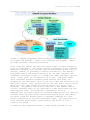
location. Figure 1 provides a step-by-step conceptual workflow.
UNICOR requires two input files as the first step: 1) a landscape
resistance surface and 2) point locations for each population or
individual's location (see section 3 for program input). Prior to
running UNICOR, users must create a resistance surface where each cell
value (pixel) represents the unit cost of crossing each location.
Pixels are given weights or „resistance values‟ reflecting the
presumed influence of each variable to movement or connectivity of the
species in question (e.g., Dunning et al. 1992; Cushman et al. 2006;
Spear et al. 2010). Resistance surfaces could be parameterized to
reflect different costs to movement associated with vegetation types,