1
5.0
Procedures
5.1
Sites
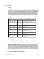
There are seven (7) sites along the tidal reaches of the Sassafras River that are monitored
according to this protocol. Site locations are given below, stored in the SRA database, labeled on
a water-resistant chart located on the RIVERKEEPER® vessel, and stored in the RIVERKEEPER®
vessel’s GPS. The samplers should familiarize themselves with the general location of the sites
prior to departure and then utilize the GPS unit to guide the vessel into close proximity of the
sites. A reasonable effort should be made to sample at the recorded location with a reasonable
tolerance for navigating and anchoring a boat in variable wind and water conditions. Sampling
within 10-15 m of the actual site location can be considered sufficient.
SRA Tidal Monitoring Sites
Site #
Longitude
5.2
Latitude
WK02
39.3674833
-75.8490667
WK03
39.3629667
-75.8909333
WK04
39.3703611
-75.9303333
WK07A
39.3805833
-75.9479500
WK07
39.3796167
-75.9328500
WK08
39.3704000
-75.9849833
WK09
39.3815833
-76.0631833
Description
20m North of Wilson Pt. duck blind.
Just inside western edge of mooring field in
the yacht basin and at the intersection of the
main stem and Dyer Creek.
~10m North of Red Nav. Buoy #10 off of
Big Marsh Pt.
Center of Back Creek just downstream
from intersection with McGill Creek
Center of Foreman Creek at intersection
with Back Creek
Southeast side of channel between Ordinary
Pt. and Kent Co. approximately across from
Green Buoy #3
North of Town of Betterton approximately
at the intersection of the Sassafras River
and Chesapeake Bay
Time Frame
Monitoring of the tidal sites will begin in April and continue through October. Each
season a specific day of the week and time should be developed to provide a consistent sampling
window to incorporate natural fluctuations in environment conditions. For 2010, first sampling
is targeted for Wednesday at 9:30am. Every effort should be made to sample at this day and
time throughout the season, however, should unfavorable weather or other situations arise that
interfere, the collection of data on another day or at another time is preferable to not having the
data for that week. Chlorophyll and nutrient samples are taken on a bi-weekly basis, while other
parameters are sampled weekly. The sites will be sampled in the in the order listed in Section 5.1
to ensure further similar sample timing.
5.3
Preparation in SRA office prior to departure
SRA Tidal Monitoring SOPs
Page 3