1
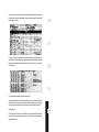
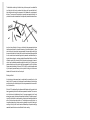
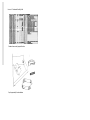
INTEGRATIONS OF MEASUREMENTS AND THE KNOWLEDGE BASE TO GENERATE A CAD
Model—on Site: Automating the Drafting for as-Found Recording and Facility
Management Surveys
by
Steve Nickerson
Nickerson & Associates, designed building systems ltd.,
Ottowa, Ontario, Canada
&
Bob Thrale
Parks Canada
&
David Whiting
Public Works and Goverment Services Canada
STEVE NICKERSON
is a private consultant speccializing in the design and implementation of CAD and
Facilities Management Systems. He is a member of recording and documentation committee and head of the Electronic Communication Working Group for ICOMOS
Canada.He is field architect and system analyst for the Humeima archeological excavations in Jordan, sponsored by the University of Victoria.
BOB THRALE
has, for the past 25 years, specialised in the surveying of sites and structures for Parks
Canada and has been extensively involved in digital data collection and computer modeling of structures and landscapes.
DAVID WHITING
is head of restoration architecture, provides conservation services to the build heritage
structures under the authority of Parks Canada, working in interdisciplinary groups
with other specialist in Cultural Resource Management.
315
Automating the drafting for as-Found Recording and Facility Management
A B S T R ACT
Much of the time of a facility planner, restoration architect or heritage recorder is spent,
on site analysing thebuilding and collecting data and measurements. These will be used
later to create the reports and drawings that will provide the basis for the subsequent
design but these notes and measurements are just the beginning of the long process of
drafting the as-found situation. Errors are inevitable in this type of work but, typically
they only come to light, back in the office where confirming a measurement may entail
an extra trip to the site, and there are times that they only turn up when a contractor
encounters problems on the job
A software tool, currently under development, addresses this problem by first helping to
structure the note taking process so that more consistent data is collected, and then, automatically creating a 2D or 3D CAD model from the resulting database. This can be done
on a laptop computer, before the recording team leaves the site so that the model can be
compared with reality and faulty or missing measurements corrected. Furthermore, this
combination of database and drawing is linked, allowing queries of the data from inside
Autocad or the assembly of a specialized model based on a database query
Point collection techniques supported include traditional and not so traditional) hand
measurement, total station surveying equipment and interfaces with other software such
as rectification and photogrammetric packages. The applications envisioned include as
found recording, facilities management data collection and the possibility of a totally
data-driven GIS.
INTRODUCTION
In the beginning there was the pencil, and in the hand of a skilled practitioner it could be
made to do a wide variety of things. It enabled the architect to describe his visions to the
client, using plans elevations and renderings, and to the builder through working drawings and specifications. In the case of existing structures needing restoration, renovation
or interior design, that same pencil produced the portraits, sketches, measured drawings
and notes that conveyed the look, layout and condition of the building to the architect
and provided the basis for the plans and working drawings that would describe the
planned intervention
The first of these functions to be affected by technology was the realistic rendering of
existing structures. Photography, was initially used to supplement the manual drawings,
later supplanting them completely except for conditions where critical details were not
distinguishable on film. Though there is still reason to mourn the disappearance of the
skilled hands that produced those architectural portraits, we have had a century to adjust,
and the photograph is now an indispensable tool for the recording and assessment of a
building
More recently, major changes have taken place on the other side of the equation, where
ideas are being put on paper, and today word processors, spread sheets, databases and
Computer Aided Drafting (CAD) are all common tools of the profession
However the initial record is still being collected primarily on paper, and later, the measurements are manually converted to CAD formats so that they may be used by the architect in that medium
Though there have been some attempts to systematize the collection of data with a view
to facilitating its input into the CAD system including hand measurements (O'Brien
1994) (Partridge 1994) and some imaginative work automating photogrammetry
(Streilein 1994), the fundamental problem is that, in spite of the success of the pencil,
tools intended for design are not well suited to recording
317
In CAD, for instance, assumptions about right angles, parallel walls and horizontal floors
that are appropriate to design are counter productive when applied to recording. At the
level of system analysis it is not surprising that a different tool would be required for the
description of an idea than for the description of an object, and just as we do not expect
photography to be able to describe a design in progress we should not expect the design
tool to do the recording
Clearly some new tools are required for recording, tools that will respect the requirements
of that discipline but still prepare the CAD models and the knowledge base on which the
subsequent design will be based.
The Project
We have developed such a tool though, in reality, its conception was not the result of
analysing the problem and coming up with the requirements for a new program. It was
brought about by the existence of a job that needed to be done and was facilitated by the
assembly of a multi-discipline team, united in the feeling that there must be a more efficient way to do it
The project, at the McLean Mill National Historic Site in Port Alberni, British Columbia,
was the recording of a collapsed structure with a view to its eventual reconstruction as a
component of a historic park. The project was conceived and headed by Dave Whiting, a
restoration architect and the team consisted of - Rod Heitzmann an archaeologist, Bob
Thrale, a surveyor and the author, a systems analyst and sometimes heritage recorder.
Later, as the program itself took shape, programming expertise was provided by Stewart
Wilson and Dave Seabright
Data Collection
We started by simply collecting data, each in his own way, the recorder measuring dimensions, the architect taking photographs and making sketches, the archaeologist taking
notes and labelling things and the surveyor collecting points in space, while the system
analyst held the rod and wondered what he would do with it all
In fact it came together quite quickly. At the end of the first day we had a pretty good idea
of the information we needed to collect, and that evening we built the first of the data
input sheets we would use to organize our field notes
The second day we used these sheets, modifying them on the fly as we discovered places
where they were lacking, and by quitting time had enough data to start "drawing". It was
obvious almost immediately that not only did we have enough data to model the object
in some detail but that we had it (or at least could have had it if we had known what we
were doing when we started) in a form that could be manipulated to build the CAD
model automatically. The data from the survey instrument was downloaded to a spreadsheet, to which the annotations of architect and archaeologist were added, all records
being coordinated by point numbers provided by the surveyor and object numbers from
the notes
This was then saved as a text file and, after considerable manipulation with a word processor using macros and global replacements, Autocad scripts were created that would draw
these objects in 3D space
This is not to say that the objects were in their correct locations; there were a number of
details to do with coordinate systems, 3D symbols inserted with negative scale factors and
the grouping of associated entities that remained to be worked out, but by then we knew
it could be done
The rest of the week was spent at the site collecting data
Some changes were made to the collection sheets, and the script creation utilities were
modified, this time using AutoLisp, because we needed a demonstration of what we were
doing to encourage further support from the client for the programming task ahead
System Analysis
When the site work was done, the focus shifted from the problems of collecting data to
those of building a prototype program to process it, and this time some effort was spent
analysing the situation
319
To facilitate both note taking in the field and entry into the computer, it was decided that
input had to be in the form of numbers and short strings, and it was noted that the different disciplines could supply the components of this database with varying degrees of
efficiency. The surveyor could provide points in space with great speed and accuracy, but
problems with access to the extremities of the objects often prevented the absolute dimen-
sions from being collected in this way so architectural hand measurement techniques
(steel tape) were adopted for the overall dimensions of the individual objects. A unique
point number and a unique object name were needed, the former easily provided by the
surveyor and the latter from the notes. Both the architect and archaeologist required fields
for non numeric data such as material type, state of preservation, associated entities, photographic frame numbers, etc. and were provided with several data fields for such codified
information as well a fifty character field for the less structured comments. However in
order to keep the database as accessible as possible from within the CAD drawing, more
extensive descriptions would be stored in text files as suggested for the Site Information
System previously described by Nickerson (1994). Finally, to provide the handles needed
by the computer generated drawing routines a system of coding point functions was
devised to tell Autocad what to do with each point
Building the Model
As the structure we had measured was too complicated to conveniently work out the
details of the CAD geometry that had hampered our earliest attempts, trouble shooting
was first carried out on a theoretical grid and, later, using measurements from a small section of hardwood floor
When the CAD models resulting from these controlled data sets could be counted on the
drawing generated by the data from the site was processed and evaluated. This was now a
test of the data we had collected rather than of the program processing it and, though
extremely encouraging, this drawing left something to be desired. The large logs supporting the fill of the dam had not been recorded in a way that could be easily automated, and
some of the boards were drawn inside out. These problems were entirely due to our
incomplete understanding of what we were doing, especially during the first few days of
recording, but luckily, other than the loose boards cleared away to expose the underlying
assemblies, these deficiencies can be rectified with further recording
Later Developments
This model used only four symbols, two cubes (left and right insertion points) and a
cylinder drawn as 1x1x1 units and scaled on insertion, plus one component block representing fasteners
This is, in fact, all that is needed to create a model of this type of object, which we treated simply as collection of dimension lumber, poles and things holding them together
However, when supplied with additional symbols such as desks & chairs, phones, sprinklers, pot sherds, coins etc. the program can produce facility drawings from a floor survey
or three dimensional archaeological maps
We already had a useful tool, but having seen what was possible using this automatic
drafting function we saw no reason to stop there. Lines and arcs would clearly be useful
for the drawing of plans and elevations and, once drawn, these CAD entities could be
extruded creating 3D models simply by measuring a point at the top of the wall or including a value for height in the database. As well, text annotating the points or labelling the
assemblies could clarify the model considerably and adding these functions was easy compared to the 3D symbols with which we had started, though the 3D arc took a while.
Current Requirements and Capabilities
Primary input for each point is in the form of three real numbers and a point identifier,
the key to the drawing system, indicates the function of each point. As well, there is a
unique point number to allow for the location of any point in the database for trouble
321
shooting in the case of missing or erroneous values and a unique object name that groups
the CAD entities into useful units and provides the link among database, CAD drawing,
photographs and text files. Scaled symbols require an additional three values for their size
and an optional field for a rotation angle, though in the field this can be more easily provided by supplying an additional point for the rotation. Beyond this are several short text
fields that accept descriptions or values to be used in layering, symbol naming etc. and a
comment field for things that would not fit anywhere else. Descriptions of the uses and
options for the different fields, and some details about the program itself, are presented in
Appendix C. The database uses the .DBF structure because of its universality and because
it can be read directly by Autocad using ADE (Autocad Data Extension)
As it stands now, measurements in the following formats are supported:
- XY(Z) conventional X,Y,Z coordinate system with the Z values optional
- AD(Z) (Angle, Distance, Z) - Polar Cylindricalmeasurements from dumpy level and
laser or digital plane table
- ADA (Angle, Distance, Angle) - Polar coordinates from a theodolite or total station
- RUN (Running dimensions) - a wall is measured from 0 to its end then placed in the
model using one of the 3d measurement systems, an existing drawing or assumptions
based on right angles.
It supports the following Autocad functions:
- 2D or 3D lines and arcs
- Extrusions (thickness) of the above
- Text annotating points or symbols
- Attributes and Extended Entity Data (EED)
- Layer creation & naming
The model consists of the following Symbol Types, all linked to the database using
Extended Entity Data:
- 2D or 3D representations of surfaces
- 2D or 3D fixed size symbols such as furniture
- 2D or 3D scaled symbols such as pot sherds and doors
- 3D solids with custom coordinate systems (UCS)
- Reference Symbols such as fasteners and condition or material annotations
- Analytical references such as densities of particular object types
- Compound symbols combining any number and combination of the above
DataBase Integration
As useful as the graphic component of this tool is, the potential of the associated database
is probably much more significant. What a recorder does is measure things and make
notes, and other than some clarifying sketches, the graphic representation of this data is
just a by-product of the original record. In most cases the CAD model created by this
method need not even be saved as it is just as easy to generate it again as it is to retrieve
it, and next time you may want to represent it differently. For instance, by changing some
global parameters, different layer groupings can be used, and component drawings can be
created of only those objects identified by a pre-defined or interactive SQL (Standard
Query Language) query. This functionality can provide a way to keep large databases, and
potentially huge drawings, manageable on normal computer equipment, even laptops
As each object is drawn, Extended Entity Data is attached to it linking it with the database that created it. When queried from within Autocad, ADE will provide displays of all
records in the database that helped to create it and, in the case of named blocks such as
furniture, doors or pot sherds, it provides access to a second database specific to that class
of object. This Xdata is also used by pre-defined queries that will display the images and
text files associated with the object
With the model stored as a database it is possible to e-mail the whole thing (less images)
as pure ACSII text in comma delimited format, to another site where it can be generated
and analyzed by the specialists who, without having to visit the site, might be able to make
recommendations on where the recorders should concentrate their efforts or on elements
that may need more detailed study
Applications
Though it was conceived in response to a problem in Heritage Recording, this tool is foreseen as having a wider application in more general architectural practices. The recording
of the existing situation is always the first step in any renovation and the possibility of collecting the necessary measurements in a way that will provide a drawing while the
recorders are still on site and able to correct the errors and omissions that inevitably occur
should be greeted with considerable enthusiasm; but probably the most promising application of this technique is the capture of the as-built and as-furnished situations of large
commercial installations where the combination of laser measuring technologies and the
automatic insertion of symbology promises to reduce the time required for data capture
and CAD modelling to a fraction of what has traditionally been required
323
A total station survey instrument can capture from 2 to 10 points a minute (it takes two
points to record a piece of furniture, one for an electrical outlet) and a crowded 20 square
meter office has about 40 objects that might be recorded in a complete survey. In 20 minutes two people can record this, build a database and generate a CAD model, a meter a
minute almost 500 square meters per day (about 5000 square feet). Using conventional
techniques on large jobs I would expect to take at least twice as long for a survey half as
detailed and the CAD drafting would not even have been started
Conclusion
It seems that we have the beginnings of a tool for Computer Aided Recording. There are
some additions and many refinements we would like to implement in order to make it
more versatile and less user belligerent but even in its present form we are using it to do
real work. Further testing is planned for several sites during the coming year including:
heritage sites in Canada and Turkey, archaeological sites in Canada and Jordan and, hopefully, a facility survey somewhere to pay for it all
ENDNOTES
1. Team Participants
Steve Nickerson . . . . . . . . . . . . . . [email protected]
- Private consultant specializing in the design and implementation of CAD and
Facilities Management systems
- Member of the Recording & Documentation Committee and head of the
Electronic Communication working group for ICOMOS Canada. (International
Committee for Monuments and Sites)
- Field Architect and System Analyst for the Humeima archaeological excavations
in Jordan sponsored by the University of Victoria
- Student at the Institute of Interdisciplinary Studies at Carleton University
Bob Thrale. . . . . . . . . . . . [email protected]
- Specialist in the surveying of sites and structures for the past 25 years for Parks
Canada which administers the National and Historic Parks and Sites
- Extensively involved in digital data collection and computer modelling of structures and landscapes
Dave Whiting. . . . . . . . . . [email protected]
- Restoration Architect for Public Works and Government Services Canada
Rod Heitzmann . . . . . . . . . [email protected]
- Archaeologist working with Parks Canada
Dave Seabright. . . . . . . . . . [email protected]
- AutoCad and AutoLisp specialist with the Tern Solution Group of Ottawa
Stewart Wilson. . . . . . . . . . . . . . [email protected]
- Freelance Software Development consultant based inOttawa
2. In reality this field is only being used in cases where databases are being created from
existing CAD drawings, such as are used in facility management. Here symbol rotation
is stored along with insertion point and scale factors as an interim step in the process of
creating the links between drawing and database. Another application of this program
but one beyond the scope of the current paper
3. My office has 42 such objects: 2 desks, 2 tables, 3 chairs, 2 filing cabinets, 7 book cases,
5 computers, 4 monitors, 3 modems, 1 printer, 1 scanner, 2 telephones, 6 electrical outlets, 2 telephone jacks and 2 waste baskets.
325
APPENDIX A. Database and Resulting Model
Database of some currently supported functions
Graphics generated by the above database
APPENDIX B. The Total Station . . . . . . . . . . . Bob Thrale
The "total station" is an electronic land surveying instrument that has applications for the
Facility Planner, Restoration Architect or Heritage Recorder for collecting building data
and measurements. It incorporates an electronic distance measuring instrument, an electronic theodolite, a microprocessor and a memory device into one system. The instrument
is set-up over an known point, referenced to a second known point, and a signal is transmitted to a reflector at an unknown point and reflected back to the instrument where the
microprocessor computes the distance and angles in both the horizontal and vertical
planes to locate the unknown point in a three-dimensional coordinate system. The data
is then stored in a memory device and eventually downloaded to a computer
In addition to the coordinate information the operator has the option of tagging the data
with a point number and/or a point code by entering the relevant data via a keypad on
the instrument
Data collected with "total stations" is very accurate and even more important the accuracy is predictable. Typically with the short ranges involved with building measurements
each point will be accurate to within 3 to 5 millimetres in "normal" operating mode and
1 centimetre in "fast" mode. Each point, other than those used for instrument location,
is measured independently of all other points so errors are not cumulative
In practice even on large buildings errors between points even on extreme opposite sides
of the building should not exceed 1 to 2 centimetres. Mitigation of survey error is beyond
the scope of this paper and the user should be well-versed in surveying theory and practice to obtain quality results
The type of reflector used for the work will have a bearing on the quality of the end
results. Reflectors are usually a ground glass prism in a plastic or metal housing and are
typically cone shaped, about 75 millimetres in diameter. For points on horizontal surfaces
a reflector mounted on a pole with a "fish eye" style levelling bubble is adequate. On vertical surfaces a small (25 millimetre diameter) reflector, commonly called a "peanut"
prism is recommended because it will fit better into corners and other tight locations. For
best results on vertical surfaces, the point to be measured is sighted with the cross hairs of
the instrument telescope before the prism is put in place
The many manufacturers of "total stations" have various schemes for memory storage
devices ranging from internal memory, micro floppy diskettes, external data collectors and
recently PCMCIA cards. Most are capable of storing 1000 or more point records and
should have sufficient capacity for at least a full day of recording. Most instruments will
interface with a computer via a common RS-232C communications connection
327
APPENDIX C. Draft User Manual (Nickerson 1995)
*** The following are excerpts from the User Manual of the as yet unnamed program,
referred to here by our working name of "d2l"
Requirements
• Software
AutoCad R12 for DOS or Windows
AutoCad Data Extension (ADE) 1.1
dBaseIII, III+ or IV for DOS
• Hardware
ADIAMachinery capable of running the above with at least 2 megs of free hard disk
space
The D2L menu there will be, on the far right of the drop down menu, an added category entitled "D2L Modeller" that will contain the following options:
• Project Data
launches dBase and the program D2L.PRG which provides the interface for additions
and changes to the database
• Settings
the user configurable component of the software, the settings file (.D2L), is presented
with the editor provided by AutoCad via the ACAD.PGP file
• Generate - this opens a sub-menu with the following options:
Generate - processes the database according to the D2L settings file with Check - processes the database stopping at each record showing the status of selected variables
• Edit Forms - provides a default recording sheet with the text editor defined by the
ACAD.PGP where it can be modified as required and printed
• New Project - Creates the files necessary for a D2L project
If these files already exist they will be renamed .??_ before they are replaced by the new
ones
• Utilities
Use - moves the picked item to the "USED" layer and presents a copy of it, in the current coordinate system, for use in reconstructions
Read - if there are text files associated with the picked object they will be presented with
a text reader/editor
View - if there are image files associated with the picked object they will be displayed
Object Data - presents the data associated with the picked object via the ADE SQL interface
The Setup Sheet
• This file provides the interface between the user and the D2L program. In it drafting
parameters are set and the composition of block and layer names are determined. Once
satisfactory settings have been determined for a particular model type it is unlikely that
they will have to be altered except to enable or disable the text options
• Once satisfactory settings have been established for a particular drawing type future projects of the same type can be initiated without any further editing
• System Variables and Values determined by the Settings Sheet
PROJ Project & Database Name - ties the CAD, Database and settings files together. It
is best kept short and must contain no numbers or special characters
DBS Data Block Size - determines the scale factor for symbolic reference blocks
CSY the type of Coordinate System used for measurements
the choices are:
XYZ - coordinates are entered as X, Y & Z values˛ Used in the reconstructions of existing CAD drawings and downloads from automated measurement systems such as the
total station
ADZ - Angle, Distance & Z value
• Used when input is from the digital plane table (either manual or laser) or an alternate download format from a total station
ADA - Angle, Distance & Angle
• Raw data from a theodolite. Requires the horizontal and vertical angles and the distance from the instrument
Point Annotation Options
PTS Point Text Size. Sets the text height to be used for point annotation. A (nil) in this
field disables the point annotation feature
PTA Point Text Angle. The World Coordinate System angle at which point annotation
text will be placed
PTL Point Text Layer. The layer on which point annotations will be placed
Information Definitions
The values for Block Attributes, Point Identification Strings, Object Identification Strings
and Layer Names are compiled from a combination of database fields and/or text strings.
Five fields are provided for each an entry preceded by a single quote (') indicates a field in
the database for the record being in processed. Any database field can be used for the Point
and Object Annotations but the comments and any numeric fields may cause problems
329
when applied to Block and Layer Names
an entry in quotes ("") indicates a text string, these must be restricted to alpha and numeric characters (no punctuation, brackets etc.)
Extended Entity Information
With the exception of the Nested blocks when each block is inserted it is labelled with
Extended Entity Data which links it to the database records that created it and optionally to a more specific database dedicated to the particular block type. The values for this
Xdata must be identified as single database fields to allow for the querying of the record
by clicking on the object
A D2L Model will consist entirely of blocks, each linked to the database records that created it and, in the case of Data and Stand-Alone Blocks, to supplemental databases specific to that class of object
• General Data
All blocks created will display this link and will display:
an Xdata tag combining an
"&" and the PROJECT name a value as determined by the GXI variable from the
settings sheet
the link is to a database in \D2L\DBF under the file name [proj].DBF˛ Block Data
Stand-Alone Blocks and Data Blocks will have this link and will display:
an Xdata tag combining an "&" and the BLOCK name a value as determined by the BXI
variable from the settings sheet
the link is to a database in \D2L\DBF under the file name [block].DBF
The different types of objects are listed below:
• User Coordinate Blocks
these blocks are used to create regularly shaped objects in irregular arrangements. They
create a user coordinate system (UCS) from the I_PT, T_PT & D_PT and then insert a
1x1x1 symbol into that coordinate system using the values from sz_X, sz_Y & sz_Z. An
example of this would be the lumber in a collapsed structure
• World Coordinate Blocks
these are assemblies of lines, arcs and P_BLKs that are drawn in their real world locations,
blocked and reinserted in the same location
• Zero based Measurement Blocks
these are assemblies of lines that are drawn starting at 0,0 and measured with running
dimensions along the positive X axis. These are then blocked and reinserted at the I_PT
and rotated towards the D_PT˛ Object Part or Component Blocks
these are symbolic representations of components of a larger block for which the database
entries will not be accessed directly but only as part of the larger assembly
They are created by a single record. An example of this type of block is the nails in a board
represented by a U_BLK˛ Single or Stand Alone Blocks these are symbolic representations
that require individual database access. They are created with a single record unless the
optional D_PT is utilized
any value in the P_ID field which is not defined as one of the previous object or point
types will be treated as an S_BLK and will be inserted if a corresponding (same name)
symbol is available
examples of S_BLKs include archaeological objects (sherd, bone), FM symbols (outlets,
switches) etc
Taking Measurements
• Because the drafting that follows the measuring of a site is completely automatic the
accuracy, completeness and consistency of the measurements and annotations becomes
the only factor controlling the quality of the model created. In the past imprecise measurements, slight irregularities in the objects and errors and omissions were all dealt with
on the drafting board and some sort of reasonable representation of the object was
achieved by the draughtsman. However, because the computer is unable to "fudge" the
data there are a couple of situations to consider.
The first are the factual (human) errors including typos, misspelled keywords, misread
tapes, omitted measurements and the like. D2L deals with these problems with its speed.
The drawing can be generated before the recorders leave the site (or even the room) and
errors of this type are almost always immediately obvious. The error point annotation and
reporting functions of D2L will indicate the erroneous record and corrections can be
made in the database and the data reprocessed until a correct model is achieved
The other is not really an "error" at all. The total elimination of the fudge factor will create models where the walls are not parallel, corners not square and floors not horizontal
and this will give the impression of poor draughtsmanship to those used to orthogonal
drawings. D2L has no intention of addressing this problem but if pretty pictures are
desired tracing over the computer generated model is an option
Data Entry
• Total Station
When using a total station to record the points the main concern is to keep the field notes
and the list generated by instrument coordinated. This is done using the point number
which is generated by the total station and entered on each line of the recording sheet
It is possible to create a program for the total station that will allow the surveyor to enter
most of the codes necessary to create the model but there will usually be a need to keep
some notes as well reading the flat file
The data stored by the instrument is downloaded to a comma delimited file and imported into a blank database using the Append NEWDATA option from the Subset Data
dBase menu
The entries from the recording sheet can then be added using either the Append or
Browse option. The total station may use either the ADA or XYZ measurement systems
depending on the software used to download the data
331
• Digital Plane Table
the Plane table uses the ADZ measurement system
The Z value is optional and can be omitted if only a 2d model is required
• Running Measurements
Elements measured using running measurements must be identified in the 0list which
separates them from the location measurements used to fix the corners which may be in
any of the supported measurement systems
• Rectifier
When using the ASR rectifier to collect points for the modeller they will be recorded in
the XYZ measurement system as a plane then inserted into 3d space according to the "register" fields
B I B L I O G R A P HY
Bayly, Biacs, Sederis, Teskey et al. 1989, Precise Engineering and Industrial Surveys,
University of Calgary, Geomatics.
Geotronics AB 1991, Technical Specifications Geodimeter 510, Danderyd, Sweden.
Nickerson, S. 1994, A Site Information System (SIS): CADD/Database Integration for
Field Use, APT Bulletin 24(1):56-62
Nickerson, S. 1995, D2L Modeller Users Manual, (c) 135479 Canada ltd. - unpublished
O'Brien, H. 1994, Computer-Aided Recording: Proper Documentation for a New
Technology, APT Bulletin 24(1):52-55.
Partridge, R. 1994, CAD and Its Emerging Role in Historic Conservation: A Case
Study, APT Bulletin 24(1):38-3.
Streilein, A. 1994, Towards automation in architectural photogrammetry: CAD-based
3D-feature extraction, ISPRS Journal of Photogrammetry and Remote Sensing, 49(5):
4-15.