1
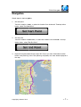
Global Navigator
ator
Global Navigator
Ultimate
te map and navigation for iPad/iPhone
User Manual 1.0
Global Navigator (GlobalNav)
v) - Navigate you around the world with your iPad/iPhone GPS
version. You can download rich resources of offline maps from Internet or create your own
using free tool of Mobile Atlas
las Creator ((http://mobac.dnsalias.org), then transfer
ransfer map files
into iPad/iPhone using iTunes'
es' file sharing.
By using offline map mode,, you will enjoy fast map display and operation,
n, you no longer
need to pay for mobile network
work data of map downloading. Before you travel
el to a new place,
you can just create the offline
ine map within several minutes and copy it to iPad/iPh
Pad/iPhone, you
can also plan the route to save
ave for future use. Never lost again no matter in
n driving, hiking,
biking or finding your parking
ng place.
★★ Catalog ★★
Features and specs ................................
.....................................................................................
........................ 2
User Interface ................................
......................................................................................................
........................ 3
Navigation ................................
......................................................................................................
........................ 7
Offline maps / Route / track
ck / bookmark export and import................................
import
........................ 9
Create offline maps ................................
.....................................................................................
...................... 11
System requirements ................................
........................................................................................
...................... 12
Version history ................................
.................................................................................................... 13
Support .................................................................................................................................
...................... 14
Copyrighs© Acamar 2010
~1~
Global Navigator
ator
Features and specs
pecs
•
•
•
•
•
•
•
•
•
•
•
•
•
•
Supports more than 30 sources of offline map b
by using Mobile Atlas Creator.
Import/export offline maps us
using iTunes.
Supports 7 online map sources.
Route planning, save, load
oad and export.
Track recording, save, load
oad and export.
POI management.
Search locally or globally
ly to llocate any place in the world.
Display engine optimized
ed ensure fast display of route with dozen of thousands
housands of way
points.
Fix location drift by enabling
abling "Mars" mode if you have such issue when
n using some
mandarin maps.
Quick buttons for fast access to frequent functions.
Auto-manage map cache
he to ensure fast map loading when using online
ne maps.
Support both portrait and
nd landscape screen orientation.
iPad/iPhone universal application
pplication with native user interface.
iPhone 4 retina supported.
ted.
Offline map support:
Supports popular RMaps/BigPl
gPlanet SQLite format (a single sqlitedb file) offline
ffline maps,
create your own map or download
wnload from Internet. More than 30 map sources
es can be choose
when you download.
By using offline map creation
on tool Mobile Atlas Creator, you can plan a route
ute and just
download the nearby area to cover the route, or you can download the fullll coverage of an
entire city or country. Map detail level can also be chosen according to you
u needs.
Use offline maps for fast display
splay and save your money.
Online maps:
Switch to online maps instantly.
antly. Su
Support 7 popular map sources.
Languages:
English and simplified Chinese.
ese.
Copyrighs© Acamar 2010
~2~
Global Navigator
ator
User Interface
User interface designed to be simple, direct and efficient.
When “Act” button pressed,, a action menu will brought to front for user to
o perform pr
proper
actions. Most actions had relations with current touch point, current track
ack and current
route.
Copyrighs© Acamar 2010
~3~
Global Navigator
ator
Action menu items:
•
Re-route
Re plan a route starting
g from current GPS location, and ending with previous
evious end point
•
Set start point
Set start point of route to plan. If end point had been set before, the route
oute planning will
performed in the background
ground and will displayed once planning complete.
ete.
•
Set end point
Set end point of route to
o plan. If start point had been set before, the route
oute planning will
performed in the background
ground and will displayed once planning complete.
ete.
•
Save route
Save current route.
•
Clear route
Clear current route.
•
Local search
Perform local search based
ased on the location of map center.
•
Global search
Search places matching
g keyword all around the world
•
Save bookmark
Save the touched point as a bookmark.
•
Clear track
Clear current track.
•
Clear route
Clear current route.
Map selection:
•
Offline maps select
Easily switch to offline maps by clicking offline maps button and choose
se desired map
•
Online maps select
Easily switch to online maps by clicking online map icon
Copyrighs© Acamar 2010
~4~
Global Navigator
ator
Bookmark, route and track
ack management:
•
Bookmark view/delete
Click the icon to displayy the saved bookmark list. Tap a item to display the bookmark in
map, slide finger from left
eft to right on the item to delete it
•
Route view/delete
Click the icon to displayy the saved route list. Tap a item to display the
he route in map,
slide finger from left to right on the item to delete it
•
Track view/delete
Click the icon to display the track list. Tap a item to display the track in map, slide finger
from left to right on the
e item to delete it
Search
•
Local search
Tap search box, type in keywords and perform local search. Local
al search’s base
location set to map center.
nter.
•
Global search
Tap “Action menu for touch
ouch point”, select “global search”. The search result will be the
places matched the keyword
yword among the world, sorting by keyword matching
atching score.
China map drift fix
Tap on the icon to toggle
le china map drift fix. If icon in Earth mode, the
e fix function will
be disabled. When the icon in Mars mode, a “fix” routine will be applied
plied to fix map
display issue when using
ng certain maps which have drift issue.
Speed display
Current GPS speed in KM/h.
KM/h
Quick buttons
•
Blue button: Lock
Toggle following GPS location.
ocation. Keep current GPS location in map center.
er.
•
Green button: Action
Perform actions.
•
Red button: Track record
rd
Copyrighs© Acamar 2010
~5~
Global Navigator
ator
Toggle track recording.
Status bar
When “Status text” enabled,
abled, a status bar will appear in the top of the
he screen. When
new location received, it will display the location format such as:
In Earth mode:
tude) A:Atitude T:Track points”
points
“(Latitude, Longitude)
In Mars mode:
titude, Fixed
“Z:Zoom level (GPS Latitude, GPS Longitude)=>(Fixed latitude,
longitude) A:Atitude
ude T:Track points”
points
Copyrighs© Acamar 2010
~6~
Global Navigator
ator
Navigation
Simple steps to start navigation:
ation:
1.
Set start point
Touch the location to start, or select the location from bookmark. Then
en tap Action
button, select “Set Start
rt Point”
2.
Set end point
Touch the location of destination, or select the location from bookmark.
rk. Then tap
Action button, select “Set
Set End Point”
3.
Route will be planned via Google maps API. Ensure you have Internet
et connection
before route planning. Once route planning completed, the route will be displayed in
the map.
Copyrighs© Acamar 2010
~7~
Global Navigator
ator
4.
Click “lock” button to follow
ollow GPS location
During navigations, the current
rrent speed will displayed in the map. If the speed
eed lower than
80KM/h, the speed text color
or will be green. If speed is between 80KM/h to
o 120KM/h, the
color will be orange. If speed
ed exceed 120KM/h, the color will turn to red.
During navigations, if you want to re
re-plan a route from current location to previous set end
point, tap on Action button and choose Re
Re-route.
Global Navigator don’t have
e voice navigation and turn-by-turn assistance yet.
Copyrighs© Acamar 2010
~8~
Global Navigator
ator
Offline maps / Route
R
/ track / bookmark expor
xport and
import
Offline maps can be exported
ted or imported using iTunes.
Routes, tracks, bookmarks, once saved, can be exported or imported using
ng iTunes.
1.
2.
Connect your iPad/iPhone
one using Apple USB cable.
cable
Start iTunes. Choose your
our iPad/iPhone, choose Apps TAB, choose “Global
bal Navigator” in
File Sharing area:
Offlne maps were files with extension of “.sqlitedb”;
“
Bookmarks saved in a file ““places.plist”;
Route saved in directory
ry “route”;
“
Tracks saved in directory
ory ““track”.
3.
Drag these files or directories
ectories from iTunes to PC (Windows or Mac) to
o export offline
maps, bookmarks, routes
tes or tracks to PC.
4.
Drag files of offline maps,
aps, bookmarks, route directory or track directory
ctory from PC to
iPad/iPhone to import.
Copyrighs© Acamar 2010
~9~
Global Navigator
ator
Details of directory structure
re of offline maps, bookmarks, routes and tracks:
ks:
places.plist
offline-map-1.sqlitedb
litedb
offline-map-2.sqlitedb
litedb
offline-map-3.sqlitedb
litedb
route/
track/
other-files.sqlite
te
other-files.sqlite
te
You can see other files endss with “.sqlite” extension, these are files of online
ine maps cache.
They can be delete safely
Larger screen shot of iTunes
es file sharing:
Copyrighs© Acamar 2010
~ 10 ~
Global Navigator
ator
Create offline maps
Offline maps creation work is easy, funny and excited. Using “Mobile Atlass Creator”, which
can be downloaded from http://mobac.dnsalias.org
ttp://mobac.dnsalias.org.
There are many tutorials in
n the Internet which are very helpful. Some off them seems to
complicated, actually, the creation of offline maps is very direct and simple:
e:
1.
2.
3.
4.
5.
6.
7.
Download and install Mobile Atlas Creator;
Start Mobile Atlas creator;
tor;
Select map source, Google
ogle terrain for example
Select area to save;
Select zoom levels;
Select export map format
mat as “Rmaps SQLite”;
Proceed “Create Atlas”.
”.
Then you can import created
ed .sqlitedb file to iPad/iPhone using iTunes. Instructions
nstructions were
illustrated above.
Using Mobile Atlas Creator
Copyrighs© Acamar 2010
~ 11 ~
Global Navigator
ator
System requirements
ments
•
•
•
•
•
iPhone 3GS, iPhone 4, iPad with GPS capability is required.
iOS 4 required.
iTunes required to import/export
ort/export offline maps.
Mobile Atlas Creator (free
ree open
open-source tool) required to create offline maps.
Route planning, location
n search needed to be done online.
Copyrighs© Acamar 2010
~ 12 ~
Global Navigator
ator
Version history
•
1.0
Initial release, build under
der iOS SDK
S
4.1.
Support iPhone 3GS, iPhone
hone 4, iPad (with GPS hardware)
Supprrt iOS 4.1
•
1.1
Build under iOS SDK 4.2
2
Support iPhone 3GS, iPhone
hone 4, iPad (with GPS hardware)
Supprrt iOS 4.2
Copyrighs© Acamar 2010
~ 13 ~
Global Navigator
ator
Support
Visit http://globalnav.yolasite.com/
site.com/ for latest information. And you can submit any
feedbacks, bug reports and
d comments using http://globalnav.yolasite.com/contact.php
m/contact.php.
Copyrights© Acamar 2010
Copyrighs© Acamar 2010
~ 14 ~