1
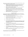
VIC AAC BDE
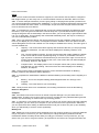
SENIOR LEADER COURSE
LEARNER GUIDE
TRIAL VERSION (PRINTED JUNE 2013)
SENIOR LEADER COURSE
COURSES CAMPS
PACKAGE CONTENTS
Study Guide Introduction
Introduction
Record of Progress
Module 1: Administration
Module 2: Fieldcraft
Module 3: Instruction
Module 4: Leadership
Module 5: Safety
Module 6: Navigation
Module 7: Drill
Trial version – printed June 2013
2
STUDY GUIDE
Introduction
1.
Your study guide has been designed to help you prepare for the course
2.
Most of the subjects covered in this study guide should be revision. However, if you find that
some of the material is new to you, spend more time on those areas.
3.
The study guide is divided up into several Modules, each of which covers a separate subject
area. The modules are arranged alphabetically, but there is no need for you to work through them in
that order – work on the modules in any order you wish.
4.
The study guide is designed so that you can work through it at your own pace. Read the
materials in each module
GOOD LUCK!
Trial version – printed June 2013
3
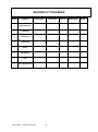
RECORD OF PROGRESS
Module
Subject
1.
Administration
2.
Fieldcraft
3.
Instruction
4.
Leadership
5.
Safety
6.
Navigation
7.
Drill
8.
Dress Regulations
Start date
Trial version – printed June 2013
Finish date
4
Result
Retest date
Result
MODULE 1 – ADMINISTRATION MATERIALS
CONTENTS
Chapter
Harassment, Discrimination and Unacceptable Behaviour
1
Duties of the Section Corporal
2
Duties of the Platoon Sergeant
3
Responsibilities of OOC
4
Explain the History of Military Uniforms and Embellishments
5
How o recognize badges of rank
6
How to write a minute
7
Annex:
A
Example of a simple minute
Trial version – printed June 2013
5
Chapter 1
HARASSMENT, DISCRIMINATION AND UNACCEPTABLE
BEHAVIOUR
HARASSMENT
1.1 Harassment can be defined as attention, actions and behaviour that is unwanted, uninvited and
unreciprocated. It can be offensive, belittling, and/or threatening and may be directed at an individual
or a group of individual. Harassment can occur through comments, touching or by visual means. It is
behaviour that makes the person being harassed ("the recipient") feel uncomfortable, intimidated,
offended or frightened.
1.2
Harassment may happen because of some real or imagined attribute or characteristic of the
recipient, such as racial origin, gender, sexual preference and so on). Examples of harassment
include:
a.
b.
c.
Sexual
(1)
An unwelcome sexual advance
(2)
Sexual comments about a person’s appearance
(3)
Unwelcome touching
(4)
Displaying pornography
Personal
(1)
Offensive comments about a person’s religion, race etc
(2)
Telling sexist or racist jokes
(3)
Insulting comments about a person’s appearance
(4)
Bullying or bastardisation
(5)
Excluding a person from activities/conversations etc
Abuse of Authority
(1)
Misusing rank to interfere with a person’s cadet career
NOTE: Legitimate comment and advice (including feedback and fault correction) is not harassment
when it is intended to improve the performance and/or behaviour of individuals or groups.
DISCRIMINATION
1.3 Discrimination occurs when a person is treated less favourably than another person would have
been because of irrelevant matters such as race, religion, marital status, sexual preference, political
persuasion, medical record etc.
1.4
Examples of discrimination include:
a.
Where a cadet is not allowed to take up a posting in the unit because of their gender,
and
b.
Where a cadet is refused a promotion because of their religion or racial origin.
UNACCEPTABLE BEHAVIOUR
1.5 Unacceptable Behaviour is any activity which adversely affects the efficiency, effectiveness and
morale of the unit or which causes a loss of respect for any member of the ACC. Unacceptable
behaviour may or may not also be a criminal offence.
1.6 Examples of unacceptable behaviour include:
a.
Sexual relations between superiors and subordinates (including adults and cadets over
the age of 16 years);
Trial version – printed June 2013
6
b.
Public displays of affection;
c.
Advocating a particular sexual preference (whether heterosexual or homosexual); and
d.
Not allowing cadets to dress/undress in private.
1.7 What to do if you feel you have been harassed. Contact your unit’s Harassment and
Discrimination officer, or if you don’t feel comfortable doing this ask a friend or your parents to do it for
you. Your complaint will then be investigated confidentially and the appropriate action will be taken.
CONCLUSION
1.8 No member of the ACC should ever be harassed, discriminated against or subjected to
unacceptable behaviour. This kind of treatment is wrong. It may also be a criminal or civil offence. It
can have a devastating effect on the individual cadet or group of cadets affected by it, and of course
on the unit as a whole.
1.9 As a person aspiring to hold rank within the ACC, you must do your part to help make sure that
this sort of behaviour is stamped out.
Trial version – printed June 2013
7
Chapter 2
DUTIES OF THE SECTION COMMANDER (CORPORAL)
2.1 The Section Commander (Corporal) commands a section of up to 10 Cadets. The duties of the
Section Commander include the following:
a.
Direct requests or suggestions to the Platoon Commander;
b.
Be loyal to superiors and to the section. It is extremely important that the Section
Commander does not voice any dissatisfaction in front of the section, but rather discuss
the matter with the Platoon Commander;
c.
Make sure that when receiving orders he/she fully understands the orders and their
scope. When issuing or passing on any order it is also important that the section fully
understands what is expected of them and that it is carried out;
d.
Submits lists of the section’s needs for training stores/clothing etc to the Platoon
Sergeant and advises any losses and damages;
e.
Continually Prove that they are fit for the job of Section Commander and at the same
time, by study and application, prepare for higher rank;
f.
Ensure that the section maintains a high standard of dress, bearing and discipline and
that clothing and equipment is kept in good order;
g.
Ensures rations, equipment, water and mail are collected and distributed;
h.
Ensures that the section duty roster is properly kept and carried out;
i.
Ensures that the section observe all orders on health;
j.
Know the strengths and weaknesses of each member of the section;
k.
Instruct individual and collectively the section in bush craft, basic map reading, first aid,
personal hygiene, section formations and movement, knots and lashings, camp craft and
cooking; and
l.
Other duties as directed by the Platoon Commander and Platoon Sergeant.
Trial version – printed June 2013
8
Chapter 3
DUTIES OF THE PLATOON SERGEANT (SGT)
3.1 The Platoon Sergeant understudies the Platoon Commander and takes command of the
platoon in the absence of the Platoon Commander. The Platoon Sergeant is the Platoon
Commander’s assistant responsible for platoon disciplinarian and administrator.
3.2 Cadets expect their Platoon Sergeant to know their jobs, to share the hardships with them and
to take a personal interest in their problems. Platoon Sergeants should ensure that section
commanders keep them advised about problems encountered by platoon members and ensure that
these problems are rectified or passed on to the Platoon Commander.
3.3
The duties of the Platoon Sergeant include:
a.
Supervising and conducting platoon drill;
b.
Checking the dress, bearing, drill and behaviour of Platoon members;
c.
Ensuring section commanders advising him/her of cadet’s problems and make sure
these are solved or passed on to the Platoon Commander;
d.
Checking lists of stores required by section commanders, submitting consolidated lists to
the Company Quarter-Master Sergeant (CQMS);
e.
Receiving stores from the CQMS and ensuring that stores are fairly distributed amongst
sections;
f.
Calling and marking the platoon roll book, submitting the roll to the Company SergeantMajor (CSM), advising of any absentees;
g.
Supervising instruction conducted by section commanders as directed by Platoon
Commander. Acting as resource person for section commanders;
h.
On bivouacs, he/she is responsible for signposting [eg: foul ground etc.], and providing
platoon guides as required; and
i.
Generally assisting the Platoon Commander.
Trial version – printed June 2013
9
Chapter 4
STATUS AND RESPONSIBILITIES OF OFFICERS &
INSTRUCTORS OF CADETS
Status
4.1 Being appointed as an Officer Of Cadets (OOC) or an Instructor Of Cadets (IOC) does not
make you part of the Australian Defence Force. You are however subject to the Cadet Forces
Regulations and ACC Policy when parading in an ACC capacity. ADF members who are OOC/IOC
are not subject to Military Regulations or the Defence Force Discipline Act whilst they are parading in
an ACC capacity.
Precedence/Compliments
4.2 OOC/IOC hold only precedence within the ACC. OOC/IOC may use military rank in all official
correspondence provided the rank is qualified by the addition of the letters "(ACC)". In other words,
the rank of Captain would be shown as Captain (ACC) of in the abbreviated from as CAPT (ACC).
4.3 OOC are to be saluted by all members of the ACC of lower rank. Whilst OOC do not have any
formal entitlement to be saluted by members of the ADF, common courtesy dictates that during ACC
activities, the normal compliments applicable to the rank of the OOC will be accorded.
Conditions of Service
4.4 The conditions of service for OOC/IOC are set out in Chapter 6 of the ACC Policy Manual 1999.
You should familiarise yourself with this material.
Responsibilities of OOC/IOC
4.5
OOC/IOC are responsible to their CO/OC for:
a.
Assisting with training, administration and discipline within the unit;
b.
ensuring health, welfare and safety guidelines are complied with, and the ACC’s zero
tolerance policy with respect to harassment, discrimination and unacceptable behaviour
is enforced;
c.
Army equipment, clothing and stores relating to the appointment they hold; and
d.
exercising a duty of care to all cadets, staff and others under their supervision.
4.6 When in temporary command of a unit, an OOC may not issue or alter any Standing Orders
without the approval of the permanent CO/OC or superior authority.
Trial version – printed June 2013
10
Chapter 5
Explain the History of Military Uniforms and Embellishment
5.1
The Army Dress Manual states that: "Australian traditions should be fostered and long existing
customs should not be lightly discarded" [para 202(f)]. The customs and traditions of an organisation
provide a link with past generations. This continuity leads to a feeling of belonging amongst group
members. The things that distinguish the ACC from other organisations is it’s customs and traditions,
and for this reason these customs and traditions are nurtured and handed down.
5.2
It is important that you have some understanding of the customs of the ACC to enable you to
pass on this knowledge to new members of your unit. If you would like to find out more, check out
your local library for books on Military history, uniforms etc.
SAM BROWNE BELT
5.3 Invented by General Sir Samuel James Browne VC. While serving with the 46 Punjabis in India
on 31 August 1858, the then Lieutenant Colonel Browne, single handedly silenced a field gun. In
doing so, however he sustained serious injuries and as a result his left arm was amputated at the
shoulder. He won his VC for this action.
5.4 General Browne continued to serve, however with no left arm he found it difficult to draw his
sword on parades etc. To solve this problem he designed a belt to hang his sword from. The belt
was supported by a shoulder strap (two were worn if a pistol was also carried). The belt was adopted
by the British Army during the Boer War (1899-1902) and by the Australian Army shortly there after.
In the ARA the Sam Browne belt is virtually the badge of rank for Adjutants and RSM’s. In the ACC,
the Sam Browne belt is worn by OOC, IOC (WO1), CUO and the cadet RSM on ceremonial parades.
CUO- BADGE OF RANK
5.5
The correct term for a CUO’s badge of rank is a "lozenge of chevronels". A "lozenge" was
originally a diamond shaped medicated lolly. The word "lozenge" refers to the diamond shape of the
badge. A "chevronel" is the term for the mini chevrons (or stripes) that make up the diamond shaped
"lozenge". The CUO badge of rank is available in two styles; DPCU field slides, and brass
ceremonial. The brass ceremonial version can be obtained from Cadet Wing.
PACE STICK
5.6
Originally intended as a training aid for drill instruction, the pace stick has now become a sort of
badge of rank for RSM’s. The pace stick opens out to form a giant pair of callipers which can be
adjusted to various regulation pace lengths. In experienced hands the open pacestick can be swung
on the march to measure out correct pace lengths. In the ACC the pace stick is carried by the
Western Region Cadet Corp RSM and by IOC’s with the rank of WO1.
SCARLET SASH
5.7
Originated in the British Army in the mid-1600’s. At that time the sash was worn around the
waist of senior NCOs as a badge of rank. Some suggest that the sash was used to carry the dead
and wounded from the battlefield, hence it’s scarlet colour. In the ARA and GRES, Sergeants, Staff
Sergeants and Warrant Officers Class 2 in the Corps of Infantry wear a "worsted" (ie: woven woollen
cloth) scarlet sash on ceremonial occasions and when acting as duty NCO. The sash is worn
diagonally on the right shoulder with the tassels hanging from the left side.
DUKE OF EDINBURGH’S BANNER
5.8
The Banner was presented to the ACC on 2 May 1970 by our Colonel-in-Chief, His Royal
Highness Prince Phillip The Duke of Edinburgh. The Banner is made of crimson silk embroidered
with gold thread. On the obverse side (ie. the side of the Banner you would see when the pike (pole)
is on your left) the Banner has the personal cipher (ie. emblem) of the Duke of Edinburgh in the top
left-hand corner. In the top right corner is the date “1970”, the year of presentation and in the centre
is the capitals insignia.
5.9
On the reverse side of the Banner is the Australian Coat of Arms. The Banner is always
carried by a CUO with an armed guard and is always saluted by members of the ACC. When carried
Trial version – printed June 2013
11
on parade the Banner takes precedence after the Sovereign’s Banner and no unit flags are flown or
displayed. The Banner may be carried on all Cadet Group activities during visits by Royalty or the
Colonel in-Chief and on other important occasions. When it is being transported throughout Australia
the Banner is stored in a velvet lined box accompanied by an ARA officer.
LANYARD
5.10 The origin of the lanyard is somewhat unclear. Some suggest it was first used as a cord to fire
artillery pieces. Others suggest that the lanyard was originally a means of tying up fodder and hay for
horses use by cavalrymen. Perhaps both are true, but in any case, the lanyard is now a colourful
means of distinguishing between different corps and units. The ACC Corps lanyard is Royal Blue and
worn on the right shoulder.
HAT KHAKI FUR FELT (“SLOUCH HAT”)
5.11 The slouch hat was originally a fashion accessory worn in the British Army in the 1850’s. In the
1860’s the “slouch hat” was adopted in the armies of Australia’s colonies and in 1885 COL Tom Price
gave it a unique aspect by having the brim turned up at the side. This practice was believed to be first
adopted by the Victorian Mounted Rifles with the right side of the brim being pinned up. This allowed
troops to look the inspecting officer in the eye. By the time of the Boer War (1899) the “slouch” was a
firmly entrenched item of the Australian Soldier’s uniform with the brim now turned up on the left to
make carrying the rifle at the slope easier. The "slouch hat" together with the rising sun badge and
emu plumes went on to become the most famous icons of Australian fighting men following the
gallantry displayed by the Australian Light Horse who wore them during World War I. (Source: For
Queen and Commonwealth, Time Life Books: 1988).
The "RISING SUN" BADGE
5.12 The origin and development of the Australian "rising sun" badge is one of the most interesting
aspects of Australian military history. It is believed to have began with a collector, a major in the
South Australian forces, who thought of the design to mount his collection of bayonets. He asked a
captain in the South Australian navy to help him build a trophy-shield, using timber and brass. This
shield seems to have come into the possession of General Sir Edward Hutton, who was appointed to
command the military forces of the new Commonwealth of Australia. The trophy of arms, fixed above
his office door, comprised a semicircular red painted board, on which bayonets and sword-bayonets
were arranged alternatively, surrounding a crown cut from sheet brass.
5.13 Specifically the weapons were the Martini-Henry rifle triangular socket bayonet and the cut and
thrust sword bayonet. In 1902 when the 1st Battalion Australian Commonwealth Horse was being
raised for service in the South African War the GOC apparently decided on a general service badge
and suggested "something like" the trophy of arms. The contingent was due to leave five days later
and the first badge was hurriedly struck. It consisted of seven triangular points above ’AUSTRALIA’
and the crown on a form of wreath base.
5.14 The design was amended for later contingents, with six intermediate points between the larger
ones. The metal around ’AUSTRALIA’ was pierced, probably to sew a piece of coloured cloth
beneath. Still later that year another variation was struck with ’COMMONWEALTH HORSE’ forming
the badge’s base; it was worn by Australian troops who went to London for the coronation of King
Edward VII.
5.15 It is possible that the badge designers were symbolically including the six-pointed
Commonwealth Star, which is the major part of the crest of Australia. The origin of the "rising sun"
title given to the badge is connected neither with the sun, nor heraldry, nor history, but with a brand of
jam. Until about 1906 the only building near Victoria Barracks, Melbourne, was Hoadley’s jam factory,
which produced a widely advertised "Rising Sun" brand. Large quantities of this jam was shipped to
the Australians in South Africa, and the jam’s trademark was striking. In Melbourne returning soldiers
were sometimes called "Hoadley’s Horse".
5.16 In 1903 the badge makers J.R. Gaunt and Sons of Birmingham designed a badge whose
basis did not change until the 1970’s. The inscription on the scroll was ’AUSTRALIAN
COMMONWEALTH MILITARY FORCES’ until 1949 when it became ’AUSTRALIAN MILITARY
FORCES’.
PUGGAREE
Trial version – printed June 2013
12
5.17 The word comes from the Hindu word "pagre" meaning a turban or scarf of muslin. It was worn
around the hat, sometimes falling onto the neck to keep the sun off. It is said that the seven-fold
puggaree used in the Australian Army represents the fact that soldiers are drawn from the six states
and the territories.
KHAKI
5.18 The word comes from a Persian word meaning "dust covered". When the British Army were
serving in India during the Indian Mutiny of 1857 they were issued with white uniforms. To
camouflage these uniforms soldiers stained them with mud, tea leaves, curry powder and anything
else that would make them less of a target. In 1898 khaki was made general issue for all foreign
service and after the Boer War (1899- 1901) it became official dress for all occasions.
PARADE GROUND
5.19 As far back as 500 AD the dead were collected and laid inside a hollow square formed by the
troops at the end of a battle. The reason for this was so that the bodies could be identified and last
respects paid to them. This area became sacred ground and as such was treated respectfully and
was not walked upon. This has been passed down through the ages and today we use the parade
ground for instruction and parades to symbolise this tradition. No one should ever use the parade
ground for any purpose other than drill.
CORPS INSIGNIA
5.20 The ACC insignia is a woven patch in gold on a royal blue background. The emblem consists
of a sword crossed by a torch of learning surmounted by a “ rising sun”. The insignia is normally to be
worn on both upper arms by all members of the AAC. Unless a woven unit insignia is approved in
which case it will be worn on the left arm and the corps insignia on the right. Available in both left and
right hand versions the AAC insignia is to be worn with the sword leading (pointing forward) 1 cm
below the point of the shoulder.
NATIONAL ADVENTURE TRAINING AWARD (NATA) BADGE
5.21 The ATA Award is a 2.5cm gold coloured metal brooch with the torch of learning centrally
placed behind a boomerang which bears the word 'ADVENTURE'. The symbol is worn 4mm above
the flap of the left breast pocket on all orders of dress except protective dress.
Trial version – printed June 2013
13
Chapter 6
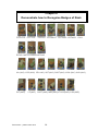
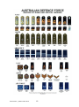
Demonstrate how to Recognise Badges of Rank
CDTLCPL CDT CPL
CDTSGT CDTSSGT CDTWO2 CDTWO1 CUO
RCUO NATCDTRSM NATCUO
UA (AAC) LCPL(AAC) CPL AAC) SGT(AAC) SSGT(AAC) WO2 (AAC) WO1(AAC)
2LT(AAC)
LT(AAC) CAPT(AAC) MAJ(AAC)LTCOL(AAC) COL(AAC)
Trial version – printed June 2013
14
Trial version – printed June 2013
15
Chapter 7
HOW TO WRITE A MINUTE
Introduction
7.1
Defence writing aims to transmit information effectively and efficiently. As with most things in
the Army, set formats and procedures apply to all correspondence sent within the Defence Forces.
7.2
This chapter will explain the format for the "Minute", which is the most common type of
correspondence you will use. During the course, you will be required to write a minute, so you should
make sure that you understand the format.
When the Minute is used
7.3
Minutes are used for correspondence within and between all parts of the Defence organisation.
Some examples of situations where you might use the minute format are:
a.
writing to your unit’s OC to suggest a training activity;
b.
writing to your unit’s GRES foster unit to organise a visit; or
c.
writing to another Army cadet unit to arrange a joint activity.
Format
7.4. An explanation of the format for a minute is set out at pages 9 and 10 of this module. Notes on
the sample minute explain its various parts. An example of a minute without the margin notes (so you
have a clearer idea of what a minute looks like) appears at page 11 of this module.
7.5. .A minute can either be typed or handwritten. If you decide to hand write your minute, make
sure your writing is easy to read.
Style
7.6. Minutes can be written in either the first, second or third person depending upon your
preference. You must try to write clearly and concisely. Other points to remember are:
7.7.
a.
The "KISS" principle – keep it simple stupid. Use short words in simple sentences. Avoid
using two words when one will do.
b.
Keep to the point and don't waffle. Say what you have to say briefly.
c.
Think of your audience. In other words, who will be reading your minute? Try to be
neither too formal, nor too casual.
An example of a Minute is at annex A.
Trial version – printed June 2013
16
EXAMPLE OF A SIMPLE MINUTE
Department of Defence
Cadet Wing
MINUTE
C-1-225-1
OC
555 RCU
For information:
CO - CDT WING
APPROVAL TO CONDUCT ACTIVITY
References:
A.
Discussion LT(ACC) Smith/WO1 Wiggins 20 Jan 00
B.
AAC Policy Manual 2004
Your request to conduct field training at the Bindoon Army Training Area between 23 – 25
May 00 in accordance with ref A is approved.
1.
2.
The Activity is to be conducted according to the principles set out within ref B.
3.
Please forward the Risk Analysis Work Sheet for the activity to Cadet Wing as soon as
possible.
M.A. SNETTERTON
MAJ(ACC)
SO2 TRG
Tel 9311 2364
22 Jan 00
Trial version – printed June 2013
17
MODULE TWO
FIELD CRAFT
CONTENTS
Patrol Orders - SMEAC
1
Demonstrate selection and preparation of a sleeping area
2
Demonstrate Erection of Shelters
3
Explain the purpose & requirements of fieldcraft
4
Explain why things are seen
5
Camouflage & concealment of self & equipment
6
Explain methods of observation & detection by day
7
Explain methods of judging distance
8
Explain target indication
9
Explain methods of observing at night
10
Explain the requirements of health & hygiene in the field
11
Trial version – printed June 2013
18
Chapter 1
PATROL ORDERS - SMEAC
1.1 As a Ranked cadet, you will be required to give orders to members of your Section/platoon in
many situations, (eg: before the start of a navex). You need to be able to give your orders in a clear,
concise and confident manner using a blueprint that ensures that nothing gets left out. Your orders
are a short and accurate summary of the task to be completed.
1.2 To help you, the method used to give orders groups in the Australian Army Cadet Corps is
called the SMEAC method. Each letter of SMEAC stands for a different heading in the orders group.
The headings are as follows:
SITUATION
-
short statement of the conditions under which the patrol, task etc will be
completed, (eg: terrain,ect).
Mission
-
a one or two sentence statement of what you want to achieve. The
mission statement is repeated so that everyone is clear about what has
to be done.
Execution
-
sets out how the patrol, task etc will be conducted, individual tasks, coordination details.
Administration & Logistics -
rations, dress/equipment, medical details, equipment needed
Command & Signals
radio frequencies, net diagram, testing of radios, alternative Signals
communications, patrol seniority list, synchronize watches.
-
1.3 You take questions 1 minute after you have finished your orders. Then you ask questions of
the people you are giving your orders to, so that you ensure that your orders have been understood.
Turn the page to see the SMEAC sequence in more detail.
SMEAC ORDERS – SEQUENCE
Warning Order
1.4 The Warning Order is as follows:
a.
Situation - a brief on the situation and the ground.
b.
General Outline of Task - a brief concept of how and what is to be
achieved.
c.
Timing or Degree of Notice - This lets the section know how long
they have before departing to achieve the mission e.g. no move before
0700 hr, or the time now is 0400 hr, notice to move from now is three
hours.
d.
RV and time for 0-Group - warns the section where to be and what time
for orders e.g. OGP at the depth pit at 0545hr.
e.
Preliminary Moves - any moves to be carried out before commencing the
mission are Advised of.
f.
Administrative Instructions - warns out the 21C what stores and
equipment he may be Getting or needs to ask for, and also gives him time
to test any equipment such as radios. He can also warn out the section as
to who carries what, how many rations they are receiving, if wet weather
Trial version – printed June 2013
19
or cold weather equipment is required and so on to allow the cadets to
prepare their equipment.
g.
Acknowledgment Demanded - always demand that your WO has been
received if sent in message form and understood, if you don't there is
always the chance that someone may have not understood it, and at
worst you could return and nothing has been done.
SMEAC
1.5 Orders are given before any activity and must be passed on down to section
level. Normally, these orders will be verbal.
a.
Before giving orders, the parts of the platoon commander's orders
relevant to the section will be extracted and the detail on how the section
is to carry out its task will be added. When the section's orders have been
given, each person should know what the platoon is doing;
(1)
WHAT THE MISSION OF THE SECTION IS; and
(2)
THE PART EACH MEMBER HAS TO PLAY.
1.6 Before commencing your orders you should give a detailed explanation of your
mud model and give a topography brief. This is essential to all to allow them to
visualise the area that they are working in and get a feel for the country. The
reason we do this is because it is rare for everyone to carry a map, and such a
brief allows them to relate to certain areas and features in the area of
responsibility that are talked about in orders. It is imperative that you explain
your mud model, or you will simply confuse others and waste your time.
1.7 Topography: This can cover any aspect of topography, not merely the lay of
the land. For instance, besides the usual brief on roads, tracks, creeks, type of
vegetation, hills and other significant features, you may also include sunrise
and sunset times, first light and last light times, moon phases, moon rise and
moon set, weather aspects (predicted temperatures, humidity, rain and cloud
cover).
1.8 Situation - this is the first point in orders and includes all relevant information
on the following areas:
a.
Friendly Forces - include in here any friendly locations, other patrol
locations and fire support available.
b.
Attachments and Detachments - let the section know if there are any
attachments. Anyone left behind from the section for any reason should
also be mentioned in orders (illness etc).
1.9 Mission - should be short and clearly expressed to everyone. This is the clear
statement of what you want your section to achieve, as well as the intent (i.e. 'in
order to'). This lets the others know why they are conducting the mission. The
most satisfactory 'format' is; who, what, where, when, why. For Example,
"Section 3 is to establish a radio position on Blakely Hill by 1800h today in
order to provide communications for the unit NAVEX'. The mission is to be
stated twice.
1.10 Execution - This is basically the "nuts and bolts" or "guts" of your plan where
you explain in detail how you are going to conduct your mission, and is broken
into the following General headings
Trial version – printed June 2013
20
a.
Concept of Operations:
(1)
Commander's Intent - what your intention is and a description of
the state of play once your intent is carried out (i.e. an end state)
(2) Main Effort - what you consider to be the most important aspect of
the tasks.
(3)
Scheme of Manoeuvre - This is where you give a generalization of
how the tasks are to be achieved, usually in phases
For examples to break a simple move in to phases, you could use:
(1)
Phase One - move to Blakely Hill.
(2)
Phase Two - establish radio position.
(3)
Phase Three - return to unit HQ.
b.
Detailed Grouping and Tasks - give the strength of the group and its
composition. ,
c.
Coordinating Instructions - give all the relevant information relating to
all your Phases e.g.
(1)
Phase One - move to Blakely Hill.
(i)
route,
(ii)
navigation responsibilities,
(iii)
boundaries,
(iv) bounds,
(v)
RVs,
(vi) formations,
(vii) order of march, and
(viii) action at firm base.
(2)
Phase Two - and so on, covering all phases in your execution.
1.11 Administration and Logistics - this is where you include all administration
that is required for your mission, such things as:
a.
Transport.
b.
Rations and water.
c.
Equipment and dress.
d.
Medical.
e.
Relief’s.
f.
Administration areas.
g.
Inspection of equipment.
h.
Equipment testing.
1.12 The administrative requirements will be dictated largely by your mission,
different tasks requiring different requirements
Trial version – printed June 2013
21
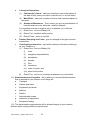
1.13 Command and Signals - included in command and signals should be such
things as:
a.
Location of commander.
b.
Any signal information such as:
(1)
Type of radio.
(2)
Frequency.
(3)
Codes.
c.
Radio silence, etc.
d.
Any codeword's, nicknames and passwords.
e.
Chain of command (seniority).
f.
Synchronise watches.
1.14 Questions - always give a set time for the cadets to take in orders then ask
questions e.g. "I will take questions in five minutes". After that ask each cadet a
question that relates to his task in orders that you have prepared prior to giving
orders. It is important to note that only the signaller and 21C need to take written
notes.
Trial version – printed June 2013
22
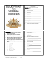
BLUEPRINT
FOR
VERBAL
ORDERS
Verbal Orders
Preliminaries:
1. Seat the members of the Orders Group in
sequential arrangement.
2. Check that they have all the equipment
necessary for the orders.
3. Make sure that they ail can see the model and
that the sun is not in their eyes.
4. Make sure that the model is orientated to the
north or south point when you construct it.
5. Make sure that there are no distractions before
commencing the orders.
6. Stick to the correct sequence of delivery of the
orders.
a.
Topography
b.
Statement
c.
Situation
d.
Mission
e.
Execution
f.
Admin & Log
g.
Command & Sigs
h.
Statement
Trial version – printed June 2013
23
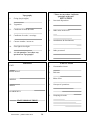
Verbal Orders
Mud Model: Explain features of the model.
1.
North Point
___________________________________________
2.
Rivers/water/creeks
___________________________________________
3.
Roads/tracks
___________________________________________
4.
Boundaries
___________________________________________
5.
Main features
___________________________________________
6.
Built up areas
___________________________________________
7.
No go areas
___________________________________________
8.
Are there any questions on the Model
1.
Verbal Orders
Topography
Current Location
2.
North point
3.
Key features outside the exercise area
4.
Key features inside the exercise area
5.
Areas out of bounds
6.
Areas of concern
7.
Boundaries
8.
Ground
Verbal Orders
STATEMENT
"These are my orders I will take
questions at the end"
Topography
9.
Going (day & night)
10.
Vegetation
11.
Condition of roads & tracks
12.
Condition of creeks / crossings
13.
Current weather / moon etc
14.
First light & last light
15.
Ask the question "Are there any
questions on Topography?'
SITUATION
1.
Own unit disposition
2.
Other units in the area
3.
Attachments & detachments
4.
Other personnel
MISSION
EXECUTION
UNIT
DOES WHAT
WHERE
WHEN
1.
Commanders intent
2.
End state
3.
Main effort
4.
Concept of operations
5.
Groupings & tasks
IN ORDER TO
STATE MISSION TWICE
Trial version – printed June 2013
24
EXECUTION
Coordinating instructions
6.
ADMINISTRATION & LOGISTICS
1.
Dress & equipment
2.
Radios
3.
Rations
4.
Water
5.
Water re-supply
6.
Medical
1.
Radio frequencies (say twice)
Key timings
7.
Boundaries
8.
Routes
9.
Action on
7.
ADMINISTRATION & LOGISTICS
CONTINUED
Casevac
COMMAND & SIGNALS
a. Primary
__________________________
b. secondary
OTHER
8.
_________________________
Transport
2.
Call signs
a. Commander
b. 21C
9.
Hygiene
c. Medic
d. 1/P1t
e. 2/P1t
10.
Ablutions
f. 3/Pit
g. Other
Trial version – printed June 2013
25
COMMAND & SIGNALS
3.
Passwords
4.
Nicknames (bounds on Nav Ex etc)
5.
Locations of Command
6.
Time Check (15 seconds, 10 seconds,
count down last five seconds)
7.
STATEMENT "That concludes my orders,
questions in _____ minutes".
MUD MODEL
Definition
1.15 Mud Models are three-dimensional representations of a piece of ground, made
of earth and natural materials which show manmade and natural features.
Preparation
Clear an area of suitable size (relative to the size of the O GP and area to be
shown).
1.16 Construct the border of sticks, rope or stones, ensuring it is large enough to
contain the model.
1.17 Orientate the map to the model; it should face the direction of travel.
1.18 Construct the areas of high ground as shown on the map, by placing mounds of
dirt on the model as they are shown on the map.
1.19 Depict other natural features on the model as they appear on the map. These
would include waterways which can be shown by either using a section of blue
coloured tape or ribbon or by simply scraping the water courses into the ground
of the model. Vegetation can be shown by either using scrim or green wool or
natural foliage can also be used.
1.20 Artificial features can be shown on the model by the use of any of the following:
Trial version – printed June 2013
26
a.
Roads can be shown as red coloured tape or ribbon or simply breaking up
some twigs and joining them in a line along the path the road takes.
b.
Railway and Power lines could be shown by the use of black coloured
tape or ribbon. They can also be shown simply by using a length of
perimeter cord or pushing small sticks into the ground of the model. Twigs
used the same way as above are also quite effective.
c.
Buildings can be shown by blocks of wood painted black (conventional
signs can be marked on then), however stones or pieces of paper with
conventional signs marked on then work just as well.
d.
Defensive obstacles can be shown by card with the correct military
symbol shown on them, or just a piece of paper with the military symbol
marked on it and placed on the model works just as well.
e.
Feature names or Spot Height numbers can be shown with either a piece
of card or paper with the name or number written on them and placed on
that feature.
f.
Artillery/Mortar Targets are shown with either a piece of card or paper with
the target number written on
g.
Them and placed on the target. Remember when using pieces of paper
they should always be anchored down.
h.
North Points are always shown on a model and can be shown by many
methods, some of which are as follows:
(1)
Place a compass on the model with the North points aligned showing
North.
(2)
Place a fighting knife on the model to indicate the direction of North.
(3)
Form an arrow with three sticks and indicate the direction of north
with them.
(4)
On a piece of card or paper draw an arrow and a North symbol and
place it on the model showing the direction of North.
North points are always placed on the inside of the Mud Model.
Use
1.21 When using the Mud Model the following actions must occur prior to and during
your Verbal Orders:
a.
Select a pointer that is long enough to reach all the points on the model
without you having to step on the model.
b.
Scat the participants, so that all can see the model, orientated to the
direction of travel and in formation.
c.
Explain what each symbol on the model represents, this must include both
natural and artificial features in a logical sequence, normally starting with
the North Point.
d.
Whichever method is used, everything on the model must be explained.
e.
Once the model is explained asked for any questions of the group, and
Trial version – printed June 2013
27
f. By the use of the pointer the model should be used constantly throughout
the orders group.
Mud Model Kits
1.22
A model kit can be made to suit each individual and for specialist
situations, but a model kit should only contain what you require to construct an
effective model. Your model kit should contain the following:
1.23 2 metres of the following coloured wools:
a.
Red - roads.
b.
Black - railway and power lines.
c.
Blue - watercourses.
d.
Green - vegetation.
1.24 Qty of card and of varying sizes of the following:
a.
Small pieces to show buildings or bridges.
b.
Medium pieces to show cuttings, obstacles and target numbers.
c.
Larger pieces to show North Points, airfields and towns.
If using card it should be covered with clear contact to save it from the
conditions and will also allow it to be written on and erased for each
orders group.
1.25 Chinagraph pencils to mark the card; they may need to be cut to fit your model
kit. Colours and qty will depend on the size of your model kit.
1.26 A number of varying coloured buttons are useful to indicate targets, RVs and
proposed halts (golf tees are ideal).
1.27 Qty of matches can be useful to show power lines, small tracks and can also be
used to prop up any card symbols.
1.28 A waterproof container should be selected to maintain your model kit, and its
contents in a serviceable manner.
Trial version – printed June 2013
28
Chapter 2
Demonstrate selection and preparation of a Sleeping Area
First Things First -Site Selection
2.1 When you become a CUO one of your jobs will be (or at least should be!) to select and site
campsites for your platoon/Section. The first thing you have to do is to select your campsite. Keep
three points in mind:
2.2
a.
Don’t rush the selection process – a better site may suggest itself if you take time;
b.
Selecting a site is important – you may have to occupy the site for several days; and
c.
Consider health and welfare aspects carefully.
Factors to Consider, are
a
b.
c.
Terrain, including:
(1)
security considerations
(2)
Platoon/Section assembly areas
(3)
Latrines
(4)
Safe cooking
Vegetation/ Environmental (minimal destruction), including:
(1)
Irritants (thorny vegetation)
(2)
Ticks (avoid blackboys/zania palms)
Slope, including
(1)
Gentle slope/higher elevation better
(2)
Determines location of facilities
d.
Prevailing Winds . (i.e. Shelter from the weather)
e.
Shade
f.
Drainage
g.
Size of site, including:
Important in summer
Soil (loam preferred to gravel or sand)
(1)
Enough room for Platoon HQ
(2)
Enough Room for the sections
(3)
Site must be large enough to allow expansion
h.
Siting of facilities (eg: rubbish/ water points, latrines not too close etc.)
i.
Access, including:
(1)
Can you get into the area easily
(2)
Resupply
(3)
Not too close to busy transport routes
(4)
Avoid dusty/boggy tracks
j.
Control Communication/control/security
k.
Local Resources Medical/Medivac facilities
Trial version – printed June 2013
29
Campsite layout
2.3
Having selected a site it is now your job to "lay out" the various facilities and your people within
the area you have selected. A commonly used method of laying out your platoon area is called the
"clockray method". Imagine that the platoon area is a giant clock. Site your platoon HQ at the centre
of the clock and then divide up the clock face to site each of your sections. Each section occupies a
third of the clock face which is broken down into 3 sectors as follows: 12 o’clock to 4 o’clock, 4o’clock
to 8 o’clock and 8 o’clock to 12 o’clock.
2.4
You should consider:
a.
HQ Area
b.
Section Living Area, including;
c.
(1)
location of section commander
(2)
section members in pairs
(3)
shelters sited according to wind
Latrines
(1)
d.
e.
f.
g.
h.
i.
j.
located at centre of the clock face for ease of communication;
down wind for obvious reasons!
(2)
down slope, away from living/stores/cooking areas
(3)
down stream, away from water course
Cooking Area;
(1)
decide if central or sections areas to be used
(2)
up wind/slope from latrines/ablution area
Ablutions;
(1)
outside living area
(2)
down wind/slope, up wind of latrines
(3)
well drained/avoid old foul ground
Water point
(1)
within living area
(2)
on opposite side to latrines
(3)
if bulk (water bladder) close to transport/access
Fire wood
(1)
outside but close to perimeter
(2)
upwind of camp fire
Rubbish Point
(1)
outside perimeter
(2)
down wind/clear of access paths
(3)
bash, burn, carry or bash, burn and bury
Platoon
(1)
adjacent/close to campsite assembly area
(2)
upwind of fire hazards,
(3)
shade would be an advantage
Store
(1)
within camp site
Trial version – printed June 2013
30
k.
(2)
clear of fire/flood hazard
(3)
within control of platoon HQ/good access
Transport
access/safety/noise/dust
Trial version – printed June 2013
31
Chapter 3
Demonstrate Erection of Shelters
3.1 The standard field shelter that you and your platoon will use in the AAC is of course the shelter
individual or "hootchie".
3.2 The hootchie is a waterproof, lightweight, oblong shaped shelter. It has stud fasteners, webbing
loops and rivet holes located around it’s outer edge and can be joined up with any number of other
hootchies. Most commonly it is joined with another hootchie to make a sleeping area for two people.
When erected properly the hootchie provides a very good level of protection from the elements.
3.3 You are responsible for ensuring that your people have a comfortable and dry night’s sleep.
Therefore check the following points:a.
Wind direction and prevailing winds.
b.
Hootchies have been joined correctly. Many recruits will do it wrong and get wet!
c.
Avoid ants nests, rocky ground, zania palms and blackboys (ticks)
d.
Dig hip and shoulder holes to make sleeping on the ground more comfortable.
e.
Look up for dead fall. Dead overhead twigs or branches which may fall in high winds.
Even a small piece of wood falling from a height can do real damage.
f.
Check that drainage has been considered.
g.
Are drainage ditches (shallow trenches) needed around the hootchie?
h.
ensure sides of the hootchie are taut to ensure good water run-off.
i.
Use quick release knots (ie: slip knots).
Shelter construction
3.4
There are three basic types:
a.
Lean-To;
b.
Inverted V; and
c.
Double Inverted V.
Lean To
3.5
The Lean-To is ideal for hot
climates as it provides a greater area for
shade and breeze. The drawback lies when
heavy rain and wind combine as the rain
can be easily swept into the sleeping area.
Trial version – printed June 2013
Lean to with sides off the ground and top at
least 80cm off the ground
32
Alternate lean too configurations
Inverted V
3.6 The Inverted V is far sturdier in a variety of climatic conditions; being erected closer to the ground to
counter the effects of wind and rain. It does not, however, allow the maximum cooling effect of any
breeze or the erection of a mosquito net.
Double Inverted V
3.7 The Double V is useful for two people. It is constructed by simply joining long sides of two
hootchies together, using the male and female studs. The construction is similar then to the single
inverted V. Make sure that the bottom hootchie is tied off through its loop to a tree at the apex, as this
will stop a gap occurring between the press-studs. Keep the shelter sides as straight and as tight as
possible. This will aid in water run off and prevent pools of water forming. Any object touching the
underside of the hootchie when it is raining will cause a leak.
Minimum height of centre is 90cm
and side seam may touch the
ground
Knots
3.8 The only knot to use when tying off a shelter is the quick release knot (slip knot). It has a single bow and
is similar to tying a shoelace. This allows the shelter to be dropped quickly to the ground if you have to leave
quickly.
SAFETY: DO NOT USE OCCY STRAPS!* Occy straps are banned in the ACC and must not be
used. Occy straps are very dangerous and have been know to cause eye injuries and even death.
Trial version – printed June 2013
33
Chapter 4
Explain the Purpose and Requirements of Field craft
THE PURPOSE OF FIELD CRAFT
4.1 Field craft is the use of natural and artificial cover to provide a measure of protection for the
cadet. Field craft and target detection training enables the cadet, by day and night to:
a.
use his senses to find the target without being seen himself;
b.
always make best use of the ground;
c.
move silently, with or without stores and equipment;
d.
judge distances accurately;
e.
be alert, confident and cunning whatever the situation may arise; and
f.
recognise and indicate targets.
THE REQUIREMENTS OF FIELD CRAFT
4.2 Training in field craft will develop the qualities of self-reliance and mental toughness required in
a cadet and will impart the confidence to exploit fully the terrain to survive and win. It will also educate
the cadet to use nature to his advantage.
4.3
There will always remain the need for individual cadets to be trained in the skills of field craft.
TERMINOLOGY
4.4 To avoid misunderstanding it is important that the meaning of the terms commonly used in field
craft is understood. Common terms are as follows:
a.
Concealment: concealment is protection from observation and surveillance. It may also
be achieved naturally or artificially. Natural concealment may be provided by the surrounding
vegetation such as trees, bushes and grass. Artificial concealment consists of camouflage nets,
camouflage cream and other materials. Whether natural or artificial, concealment hides or
disguises a cadet, a position, a vehicle or a route. Concealment is aided by avoiding light,
noise, movement and strange smells. Concealment from ground observation may not prevent
observation from the air.
b.
Detection: detection is the discovering the existence of an object and its location. It may
be the result of a deliberate search or come from the appearance of dust, flash, noise or
movement.
c.
Observation: observation involves a careful study of the terrain and vegetation. Good
observation will allow a composite picture to be built up. It may occur over a long time or may
require the employment of a number of techniques before the full situation is revealed.
Trial version – printed June 2013
34
Chapter 5
EXPLAIN WHY THINGS ARE SEEM
5.1 Valuable information will continue to be gained by the individual cadet who uses the skills of field
craft in conjunction with his sense of sight, hearing, smell and touch. Every cadet must therefore be
trained to use his natural senses.
Why Things are Seen
5.2 The use of sight is the primary means by which man gathers and assimilates information. An
understanding of why things are seen will help the cadet to conceal himself and his equipment. It will
also assist the cadet in searching for and detecting others. It is therefore important that the cadet be
taught how best to use his sight to his advantage.
5.3
The following factors will make an object easier to see:
a.
Shape: military equipment and the human body are familiar outlines to all cadets. They
can be recognised instantly particularly when they are in contrast with their surroundings.
Distinctive Shapes which are easily detected unless concealed are: head dress, basic
webbing equipment, and boots.
b.
Shadow: there are different types of shadows. Shadows are seen as follows:
(1)
Cast Shadow: in sunlight/moonlight an object casts a shadow which may give
away its presence. An object which is concealed in other shadows is harder to
detect and does not cast a shadow of its own. As the sun/moon moves so do the
shadows. Objects which were concealed by shadows may be revealed as the
shadow moves. They may also be revealed by their own distinctive shadow which
reappears.
(2)
Contained Shadow: shadow that is contained within a space, for example, in a
room, a cave mouth or under an individual shelter. It is normally darker than other
shadows, therefore, attracts attention.
c.
Silhouette: any object silhouetted against a contrasting background is conspicuous.
Smooth, flat backgrounds such as water, a field, or worst of all, the sky should be
avoided. An object may also be silhouetted if it is against the background of another
colour. An uneven background such as a hedge, bush, trees or broken ground will
provide the best concealment.
d.
Surface: if the colour and texture of the surface of an object contrasts with its
surroundings it will be conspicuous. Shiny helmets and white skin contrast violently with
most backgrounds and need to be disguised to assist concealment.
e.
Spacing: natural objects are rarely, if ever, regularly spaced. Regular spacing draws
attention to the fact that something other than a natural object is present. It is
conspicuous and should be avoided.
f.
Movement: sudden movement attracts the eye. Slow and careful movement is much
less likely to disclose the location of a well concealed position than quick and short
movement.
Trial version – printed June 2013
35
Chapter 6
CAMOUFLAGE AND CONCEALMENT OF SELF AND
EQUIPMENT
General
6.1. Personal camouflage techniques are designed to deceive. A cadet must learn how to guard
against observation.
6.2. Effective camouflage of the individual depends mainly on the choice of background and its
correct use. The term "background" is used to describe the area surrounding an object when seen
from the ground or the air. It is the controlling element in personal camouflage. The clothes that are
worn must blend in with the predominant colour of the background. Skin and light coloured equipment
are toned down for the same purpose. The individual cadet must practice blending with the
background by hiding in shadows and avoiding contrast between their silhouette and the background.
To enable them to do this they must be practiced in the skills of camouflaging themselves and their
equipment.
Skin
6.3. Exposed skin reflects light and contrasts with the surrounding background. Face, neck, hands
and lower arms, (which may be exposed below the shirt), should be toned down by painting them in a
disruptive pattern, by toning them down in an even colour or by wearing additional accessories, such
as scarves and gloves. When using disruptive painting the patterns should be cut across nose lines,
cheek bones, eye sockets and chin lines. A darker treatment of the skin will be necessary for night
work. Camouflage cream, burnt charcoal and dirt can all help to tone down skin colours.
6.4. Individual camouflage requires planning, thought and imaginative use of materials at hand. This
applies to camouflage of clothing also. In the absence of issued camouflage uniforms the cadet can
make his own camouflage suit, adapting its colour and pattern to the terrain in which it is to be worn.
Remember that the use of camouflage clothing and equipment is only the basis for good
concealment.
6.5. Boots. shiny boots look good on the parade ground but are out of place on a soldier in the field.
Polish or dubbing should be applied to preserve the waterproofing of boots but they should not be
shined.
Bush hat
6.6. The floppy cloth bush hat has a distinctive shaped crown which can be broken up by the use of
garnishing or a small amount of vegetation.
Webbing Equipment
6.7. The solid green colour of the webbing equipment can be modified by irregular painting using
colours such as brown, black, ochre, grey and light green. The shape of webbing equipment such as
packs, pouches and water bottles can be broken up by using hessian garnishing & foliage.
Shiny Objects
6.8. All shiny objects must be concealed. This includes such items as watches, belt buckles and
messing items.
Trial version – printed June 2013
36
Chapter 7
EXPLAIN METHODS OF OBSERVATION AND DETECTION
BY DAY
Scanning and Searching.
7.1 To find an object hidden by those skilled in camouflage and concealment, you must learn how
to observe by scanning and searching. You must also know how to apply the factors which determine
why objects are seen, as this knowledge will assist in finding the object.
7.2 Scanning is a general and systematic examination of an area to detect any unusual or significant
object or movement. Searching, on the other hand, involves a detailed look at an area where the
object is suspected to be. Both require complete concentration combined with knowledge of why
things are seen and the principles of camouflage and concealment.
7.3
Scanning. To scan an area the following actions must be undertaken:
a.
Divide the area into foreground, middle distance and distance;
b.
Scan each area horizontally starting with the foreground. To obtain maximum efficiency,
move the eyes in short overlapping movements. Moving the head will minimise eye
fatigue. The speed at which scanning is carried out will depend on the type of country
and the amount of cover it affords to possible targets;
c.
When horizontal scanning is completed, scan along the line of any features which are
angled away from the observation position.
7.4 Searching. Searching may take place at any stage during scanning. That is, if your attention is
dominated by a piece of ground, you should search that area thoroughly before continuing with
scanning. Furthermore, any significant movement or object, suspected camouflage, etc spotted during
scanning would require an immediate search of that area. Binoculars are a useful aid when searching
ground in detail.
7.5 In turn search for each of the factors that make an object visible. The weather may assist when
searching an area. For example, frost will reveal tracks made during the night or a hot sun will alter
the tone and colour of cut foliage used for camouflage by ageing the leaves more quickly.
Trial version – printed June 2013
37
Chapter 8
EXPLAIN METHODS OF JUDGING DISTANCE
General
8.1
When an object is detected it is important to be able to estimate the range correctly. There are
two main methods of judging distance without aids. They are;
a.
by the unit of measure, and
b.
the appearance method.
The Unit of Measure Method
8.2 To use the unit of measure method, visualise a known distance on the ground and calculate
how many of the units would fit between the observer and the object. An easy figure to use is a unit of
100m. This method gives acceptable results when:
a.
the observer can see all the intervening ground, and
b.
the distance to be estimated is not greater than 400m.
The Appearance Method
8.3 The appearance method of judging distance is based on what an object looks like compared to
its surroundings. To become proficient in judging distance by this method a great deal of practice is
required, under varying conditions of ground and observation.
8.4 The amount of visible detail of a cadet at various ranges gives a good indication of the distance
they are away. An observer with good vision should be able to distinguish the following detail:
8.5
a.
At 100m; clear in all detail.
b.
At 200m; clear in all detail, colour of skin and equipment identifiable.
c.
At 300m; clear body outline, face colour good, remaining detail blurred.
d.
At 400m; body outline clear, remaining detail blurred.
e.
At 500m; body begins to taper, head becomes indistinct.
f.
At 600m; body now wedge shaped, no head apparent.
Conditions effect the appearance of objects as follows:
a.
b.
Objects seems closer than they are, when:
(1)
the light is bright, or the sun is shining from behind the observer;
(2)
they are larger in comparison with the surroundings;
(3)
there is dead ground between the object and the observer; or
(4)
they are higher up than the observer.
Objects seem farther than they are, when:
(1)
the light is bad or the sun is shining in the observers eyes;
(2)
they are small in comparison with the surroundings;
(3)
looking across a valley or down a road or tack, or
(4)
the observer is lying down.
Trial version – printed June 2013
38
AIDS TO JUDGING DISTANCE
8.6 Accurate judging of distance is a skill that you must develop in order to be able to estimate a
distance to an object effectively. It is important that you know all the recognised methods of judging
distance and any aids which can be used to help you.
8.7 Bracketing. is the method most likely to prove the best under all conditions. You should decide
on the furthermost possible distance and the nearest possible distance to the object. The average of
these is taken as the range. For example, if the furthest estimated distance is 1000m and the nearest
distance is 600m then the range is therefore 800m.
8.8 Halving. The halving method is useful for judging distance up to 1000m. The observer estimates
the distance to a point half way and in a direct line to the object he then doubles it. The main
disadvantage of this method is that any error made in judging the distance to the halfway point is
doubled for the full distance.
8.9 Key Ranges. When the range to any point within the arc of observation is known, the distance
to another object can be estimated from it. This method is successful provided that the object is
reasonably near to the key range object.
8.10 Unit Average. Provided that there is sufficient time available, the observer should get several
cadets to estimate the distance to the object. He should then take the average of their answers. If all
the cadets are practiced in the skills of judging distance this method can be particularly accurate.
8.11 Binoculars. Binoculars can be used to estimate distance, particularly at long range. Using the
sub tension rule that one mil subtends 1m at 1000m the graticules of the lens of the binoculars can be
used provided the height of an object is known. If an object is known to be 4m high and it is exactly
covered by the smallest graticule it will be about 1000m away. If the object is 8m high then it will be
2000m away if it is exactly covered by the small graticule.
8.12 Range Cards. Range cards enable estimated or measured ranges of specific features to be
used as indicators to the range of an object. Normally they are used in a static position, however,
patrols should prepare them when time allows.
Trial version – printed June 2013
39
Chapter 9
EXPLAIN TARGET INDICATION
9.1 The methods of target indication are as follows:
a.
Direct Method
b.
Reference Points
c.
Clock Ray
d.
Hand Angles
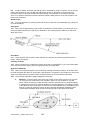
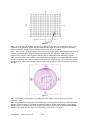
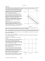
9.2 Direct Method. The direct method is used to indicate an obvious target. Only the range, where
to look and a description of the target are given. Terms used to describe where to look are as follows:
a.
"Axis" for target on or very near the centre line of the sector.
b.
"Left" or "Right" for targets 1600 mils from the axis of the sector.
c.
"Slightly left/right" for targets between the axis and "left" or "right".
d.
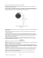
An example of the direct method given from an observer where the sector covers 3200
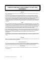
mils is detailed in figure 1.
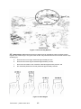
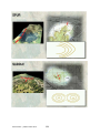
Figure 1- The Direct Method
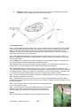
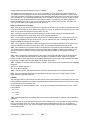
9.3 Reference Points. To indicate less obvious targets, a reference point may be used together
with the direct method. To use this method:
a.
give the range to the target,
b.
nominate the reference point and use it as the axis,
Trial version – printed June 2013
40
c.
give a direction as in the direct method, and
d.
briefly but accurately describe the target.
e.
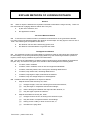
An example of the Reference Point method is shown at figure 2
Figure 2- The Reference Point Method
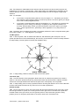
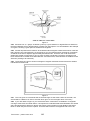
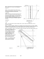
9.4 Clock Ray. To indicate more difficult targets the reference is combined with a clock ray. During
indication it is imagined that there is a clock face standing up on the landscape with its centre on the
reference point. To indicate a target:
a.
give the range to the target;
b.
nominate the reference point;
c.
imagine the reference point as the centre of a vertical clock face. Imagine a straight line
from the reference point to the target and state the direction either "right" or "left" and
"time" (to the nearest hour); and
d.
describe the target briefly but accurately.
c.
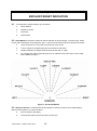
An example of the clock ray method is shown at figure 3.
Trial version – printed June 2013
41
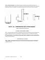
Figure 3- The Clock Ray Method
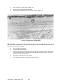
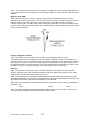
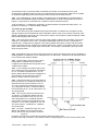
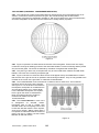
9.5 Hand Angles. Difficult targets at longer ranges may be indicated by using a reference point
together with a hand angle. As a guide, with the arm fully outstretched from the shoulder and one eye
closed (fig 4):
a.
the thickness of one finger subtends approximately 20 mils;
b.
the thickness of two fingers subtends approximately 40 mils;
c.
the first two knuckles of the closed fist subtends approximately 50 mils; and
d.
the closed fist (without the thumb) subtends approximately 150 mils.
Figure 3- Hand Angles
Trial version – printed June 2013
42
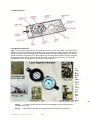
9.6 Viewing Instruments. The graticule (scale) on the lens of the binoculars are spaced at
intervals of approximately 10 mils across a field of view of about 80 mils and these may be used when
appropriate to assist in indication. The detail of the graticules in the binocular is shown in figure 5.
Figure 3- Graticules on a binocular
FAILURE TO RECOGNIZE A TARGET
9.7 If an observer fails to recognize a target being indicated he should tell the person indicating the
target to repeat his instructions. He does this by calling "NOT SEEN" or "AGAIN NOT HEARD".
9.8 The originator must if the observer failed to understand the indication indicate the target again
by a different method, or if the observer simply failed to hear the indication he must indicate the target
again by the same method.
RECOGNITION OF A TARGET
9.9 An observer should always tell the person indicating the target that it has been recognized by
calling "SEEN". If time permits, the observer should check back the target using any of the target
indication methods.
Trial version – printed June 2013
43
Chapter 10
EXPLAIN METHODS OF OBSERVING BY NIGHT
10.1 The Human Eye. Light enters the eye through the pupil. The amount of light is controlled by
the iris. The light passes through the lens and is focused on a sensitive area called the retina. From
here the optic nerve transmits electrical impulses to the brain. In fact it is the brain which sees rather
than the eyes. The retina is composed of two sets of cells, named for their shape. There are rod cells
and cone cells. The cone cells are used in daylight, they see colour, sharp contrast and shape. The
cone cells are found predominantly behind the pupil in an area called the cone region. There are
approximately seven million cone cells in the human eye.
10.2 The rod cells are used at night. These cells are located around the cone region on the outer
portion of the retina. There are few rod cells in the cone region but they are of an insufficient number
to allow night vision for any period of time. There are 130 million rod cells in the eye. They only see
black and white and shades of grey. In order to see effectively at night the rod area of the eye must
be used.
10.3 Dark Adaptation. Dark adaptation is allowing the eyes to become capable of seeing under low
illumination conditions. Most people have wondered what happened to their ability to see when they
have gone into a matinee movie on a bright sunny day. They probably not only had difficulty trying to
find a seat but were completely unsure of themselves. These few minutes of blindness were caused
by the following:a.
all of the cone cells are blind in the darkness;
b.
a chemical compound called visual purple is being manufactured in the eye to sensitise
the rod cells enabling them to see; and
c.
the pupil of the eye must expand to allow light to enter the eye.
d.
The amount of time it takes to become dark adapted depends upon the individual’s
physical make up. Some people become partially night adapted in six to ten minutes;
others take much longer. However, to become 98 percent dark adapted, it takes the
average individual approximately 30 minutes.
10.4 "Off Centre" Vision. If at night an observer looks directly at a small or dim object it may not be
seen at all as only the cone region of the eye is being used. Off centre vision is used to put the rod
region of the eyes into play instead of using the blind cone cell area directly behind the lens.
10.5 To achieve off centre vision the eye should be “aimed away” from the object about a fist’s width
to arms length (100 to 130 mils). Only by experiment can the cadet find out which direction is most
suitable for his "aim off" ie. above, below or to one side of the object. It is important that the cadet
resists the temptation of a direct look "just to make sure".
10.6 Scanning. Scanning is the short, abrupt movement of the eye over or around an area of
observation or an object that is being kept in view. The reason that an observer must apply scanning
is that the visual purple which sensitises the rod cells will bleach out after being exposed from 4 to 10
seconds. When the one group of rod cells are no longer sensitive to night light objects, another group
of rod cells must be brought into use by shifting the visual axis. Therefore, every four to ten seconds
an observer must shift his visual axis. Another reason for scanning is that the rod cells can see
something that is moving but are not capable of seeing while they themselves are in motion.
Therefore an observer must move his eyes quickly so that a new group of rod cells is stimulated to
allow detection of movement. Scanning is used in conjunction with off centre vision to gain the
maximum use of the eyes at night.
10.7 It is important to note that this technique differs from daytime scanning. In daylight the observer
searches by moving his eyes from left to right in overlapping parallel bands from near to far. If he
uses this method at night he would tend to be using the same set of rod cells constantly and would
have his eyes in movement most of the time. Therefore he would achieve nothing.
Trial version – printed June 2013
44
10.8 Staring. It is important to realise that when staring at a stationary light or prominent object in an
otherwise black scene the object may start moving. This happens because the eye has no bearings
on which to check the exact position. This can be prevented by "placing" an object against something
else such as a finger at arms length.
10.9 Confidence. To gain confidence in the ability to see under low light levels you must use your
eyes properly. You must believe what his eyes tell you. Because the rod cells don't work in the same
way as the cone cells, objects at night tend to be fuzzy and hazy around their edges and not as clear
cut. Through practice you will learn to recognize objects at night and know how they differ from their
daytime appearance. Night familiarity only comes with constant practice. Once you are familiar with
the techniques of seeing at night, confidence for night operations will quickly follow.
Trial version – printed June 2013
45
Chapter 11
EXPLAIN THE REQUIREMENTS OF HEALTH AND HYGIENE
IN THE FIELD
General
11.1. Personal hygiene can be defined as "Those individual measures, primarily within the
responsibility of the individual, which promote health and limit the spread of infectious diseases,
chiefly those transmitted by direct contact".
11.2. Personal hygiene measures include:
a.
washing your hands in soap and water immediately after going to the toilet and before
handling or eating food.
b.
keeping your hands and unclean articles, or articles that have been used for toilet
purposes by others, away from your mouth, nose, eyes, ears, genitals & wounds.
c.
avoiding use of unclean eating utensils, drinking cups, towels, handkerchiefs, combs and
hairbrushes.
d.
avoiding exposure to other persons spray from the nose and mouth, as in coughing,
sneezing, wheezing, laughing or talking.
e.
wash hands thoroughly after handling a patient or his belongings, and
f.
keep your body clean by frequent soap and water baths or showers.
11.3. The Skin. The skin is the largest organ of the body and is necessary to life. Its primary
function is to protect the tissue beneath and in spite of its thinness furnishes a surprising amount of
protection against:
a.
blows and friction;
b.
the chemical action of certain chemicals;
c.
bacteria, and
d.
other hazards which may be harmful to life.
11.4. The skin also:
a.
regulates body temperature, heating & cooling the skin by altering blood flows;
b.
possesses sensory functions - warning of touch, pressure, heat, cold and pain;
c.
is a secretory and excretory organ (eg: sweat, oil);
d.
is fairly waterproof - few substances can be absorbed through the skin; and
e.
stores fat and can manufacture Vitamin D when exposed to sunlight.
11.5. Where possible, therefore, all parts of the body should be washed daily, paying particular
attention to the parts where sweat collects (eg. armpits, waist, crotch, and feet). The hair should be
kept short.
11.6. Soap. To help maintain the skin it is essential to remove accumulated fatty deposits, dirt and
cellular debris. This is done by using soap and water. T he soap must:
a.
wet both the dirt and the surface to lower surface tension;
b.
reduce the force of attraction which holds the dirt on the surface to allow the dirt to be
displaced; and
c.
keep the dirt particles dispersed so they can be washed away.
11.7. Showers/Baths. In warm and especially humid climates it is natural to perspire freely and parts
Trial version – printed June 2013
46
of the body subject to this need special attention. Daily washing and careful drying are essential to
protect against Tinea and similar fungal infections, as well as the usual bacterial and parasitic
problems. Whether a bath or shower is taken is irrelevant but what should be remembered is that a
warm or hot bath or shower relaxes and soothes where as a cold one stimulates.
11.8. Ears. The ears are very sensitive organs and require gentle care. The normal secretions of wax
in the ear prevent the skin from cracking and drying out and therefore prevents infection which may
occur in the cracks. Ear infections can be very painful and are common in hot and humid climates.
Swimming in dirty water and the collection of sweat and dirt in the ears can be a cause. In instances
where problems occur medical attention should be sought.
11.9. Eyes. Healthy eyes need little special care. Using them for reading or watching television will
not harm them though overuse may cause general fatigue. There are however several precautions
which may help maintain optical health:
a.
when reading or writing make sure lighting is adequate by using bulbs of 75-100 watts.
Sit so that light shines onto your work without causing shadows or glare;
b.
hold reading material 40 to 45 cm away for normal vision;
c.
rest the eyes occasionally by looking away into the distance at a dark object; and
d.
use your own flannel and towel.
11.10.
Teeth. Teeth should be cleaned each night and morning and after meals. At least once
a day five minutes should be set aside for care of teeth. The teeth and gums should be brushed,
using a circular motion, both inside and out. Dental floss should be used between the teeth to prevent
the plaque in places where the tooth brush cannot reach. A soft toothbrush and fluoride toothpaste
should be chosen.
11.11.
Hair. Hair should be brushed twice daily and combed as often as required. It should also
be washed regularly depending on the weather, the work done by an individual and the make up of
the hair (greasy/dry). Usually two separate washings with warm water and shampoo are required to
remove oil and dirt from the hair. Thorough rinsing is essential after the second wash.
11.12.
Dandruff (Seborrhogic Dermatitis) is a chronic oiliness and scaling of the scalp which
produces a degree of inflammation. The cause is unknown but the condition is not contagious or
infectious nor does it cause permanent hair loss. A medicated shampoo, prescribed by a Doctor, will
control dandruff.
11.13.
Hands And Feet. When operational circumstances permit always:-
a.
keep nails short and clean;
b.
wash hands before eating and after every visit to the latrines or urinal;
c.
wash feet daily, and
d.
change socks daily.
e.
Failure to comply with the last two items may lead to fungal infections such as Tinea.
11.14.
Tinea is a fungal infection that is very infectious. Tinea can be passed on by direct
contact, but is more commonly contracted through infected baths, showers (especially communal),
bath mats or even floors. Once it develops it can only be eradicated completely and permanently by
prolonged and persistent treatment which, apart from washing of the feet and changing socks daily,
involves:
a.
drying feet thoroughly after washing (especially between the toes);
b.
if you sweat a lot, bath the feet in a solution of salt and water (2 dessert spoons of salt/1
litre of water) with sufficient Condy’s crystals dissolved in it to make it bright pink in
colour;
c.
after bathing and thorough drying sponge with methylated spirits (after shave lotion has
this as a base) and dust with talc powder (issued through Q store);
d.
expose the feet to air as much as possible, wear sandals instead of shoes/boots;
Trial version – printed June 2013
47
e.
don't wear thick woollen socks in hot weather;
f.
disinfect socks, slippers, shoes and boots regularly;
g.
soak socks before washing in a 20% solution of disinfectant;
h.
ensure that shoes/boots fit properly and do not chafe anywhere, and
i.
avoid going barefoot in public bathing areas.
11.15.
Clothing and Footwear. Along with body cleanliness, attention to clothing is a vital part
of personal hygiene. This is especially true in Australia, where high temperatures and humidity are
found throughout the country. Heavy perspiration may be experienced without exercise or
occupational influence and underclothing must be changed regularly as part of the general routine of
personal cleanliness.
11.16.
Dirty clothing can contain bacteria which when rubbed against the skin can find a way
through minute cracks, abrasions and the pores of the sweat glands and cause boils, carbuncles and
other skin infections. Clothing should be changed and washed as often as possible. Modern
detergents and washing powders allow clothes to be washed more completely and more easily than
before. Care must be taken however to rinse thoroughly, as residues of detergent will irritate sensitive
skin.
11.17.
Choice of Clothing. Clothing choice will depend upon:
a.
Insulation ability. air is a poor conductor of heat. Closely woven garments prevent
cooler outside air mixing with warmer air trapped close to the body. Conversely, open
weave garments allow considerable transfer of heart from the body to the outside air and
are best suited to warm climates.
b.
Absorbency. the extent to which clothing absorbs moisture will influence it’s suitability
under various conditions. Water is a better conductor of heat than is air. Garments which
become wet quickly, will cling to the skin and conduct heat away from the body.
c.
Colour. dark coloured clothing absorbs heat, light colours reflect heat away;
d.
Movement. clothing which restricts body movement is to be avoided.
e.
Boots. should be properly fitting and kept pliable and in good repair. They should not be
shared. Foot wear such as rubber boots should, if possible, only be worn for short
periods and thoroughly dried inside afterwards because they do not allow perspiration to
evaporate and escape and therefore must be treated carefully.
11.18.
Exercise. Exercise is part of healthy living. It stimulates the various body functions and
provides mental and physical charge, as well as relaxation for people employed is desk type jobs.
The importance of regular exercise is today unquestioned in regard to prevention of heart disease and
digestive problems. Forced exercise is always unpalatable and may be dangerous if consideration is
not given to the suitability, physically and mentally, of the subject.
Trial version – printed June 2013
48
MODULE THREE
INSTRUCTION MATERIALS
CONTENTS
Chapter
Steps in the Development of Instruction
1
Lesson Structure Checklist
2
The Data projector
3
Effective Speaking
4
Communication Techniques
5
Communication DO’s and DONT’s
6
Questioning techniques
7
Training Aids
8
Trial version – printed June 2013
49
Chapter 1
STEPS IN THE DEVELOPMENT OF INSTRUCTION
[Taken from the Instructor’s Handbook, paragraphs 301-313]
INTRODUCTION
1.1 Developing a lesson consists of a series of common sense steps. This chapter describes the
steps which apply to the preparation of all methods of instruction. These steps will help you to prepare
lessons based on the best sequence for learning and mean that your lessons can be given in the
most efficient and effective manner.
Development of Instruction
1.2
There are 10 steps in developing a lesson. These steps are:
a.
Examine the Instructional Objective ("IO")
b.
Study the subject
c.
Design the test
d.
Prepare the body
e.
Prepare the introduction
f.
Prepare the conclusion
g.
Prepare the training aids
h.
Prepare the lesson plan
i.
Rehearse the instruction
j.
Prepare the location
1.3 Step 1: Examine the Instructional Objective (IO). IO’s ensure that the lesson is planned to
achieve specific new learning which can be confirmed by the test of objective. The IO is the learning
target for the lesson. The columns on the IO contain the following information:
a.
Task: what the students will perform as a result of the lesson.
a.
Conditions: the aids or material that the students can or can’t use to achieve the learned
performance. Also describes the setting for the lesson.
b.
Standards: the level of performance the students must reach as a result of the lesson.
1.4 The use of IO’s in developing instruction is contained in Annex A to Chapter 3 of Instructor’s
Handbook.
1.5 Step 2. Study the subject. Instructors must thoroughly study their subject and know how to
perform the skills required. This step involves gathering materials and information that will give the
instructor the expertise to conduct the instruction. Where physical skills are involved, most of the
necessary information is contained in the relevant Manual of Land Warfare (MLW) pamphlets. MLW
pams dealing with weapons and equipment contain training chapters which will help you with this
step. The instructor must become experienced in handling the weapons or equipment that will be the
subject of the lesson. It is no good fumbling when you are trying to teach someone else! Practice and
seeking help from experienced instructors before the lesson is the key.
1.6 Step 3. Design the test. Every period of instruction must have a test of objective to confirm
that the students have understood the lesson. The test is the focus for the planning of instruction and
is based on the information in the IO. The steps in preparing tests of objective are shown in Annexes
A to C, Chapter 10 of the Instructor’s Handbook.
1.7 Step 4. Prepare the body. The body contains the teaching and practice stages of the lesson.
The lesson content must be aimed at helping students achieve the performance specified in the IO.
The five steps in preparing the body are:
Trial version – printed June 2013
50
a.
Derive teaching points: teaching points are the knowledge and skills required by students
to achieve the task specified by the IO. For example, the following are some of the
teaching points applicable to the performance statement "Interpret the conventional signs
used in map reading";
(1)
Identify the legend of a map,
(2)
Identify written descriptions and corresponding symbols used in a legend,
(3)
Identify the colour coding of conventional signs, and
(4)
Identify natural/man-made features on a map using conventional signs.
b.
Sequence teaching points: teaching points must be arranged in a logical sequence. For
example, simple skills should be taught first followed by more complex skills. Presenting
information in a logical order helps students to learn in a step by step manner. After the
teaching points are arranged in a logical sequence they are grouped together into
stages.
c.
Plan the Stages: each stage should be taught and confirmed before the next is
undertaken. The practice stage starts with a talk-through practice, moves on to an
abbreviated talk-through practice, and then finally to a to controlled practice.
d.
Plan the Training Aids: the instructor should decide on the training aids that are needed
to support the presentation and practice of teaching points.
e.
Plan the Location: the setting for the lesson is very important. A recce of possible
locations helps the instructor to select the best site to deliver the lesson. The recce also
helps the instructor to decide where to put the training aids and whether any preparation
of the site is required.
1.8 Step 5. Prepare the introduction. Once the body has been finished, it is time to prepare the
introduction. The introduction has three parts, the preliminaries, revision and the approach. The
revision you choose should be something which helps to prepare students for the lesson you are
about to give. In other words, the revision will be some skill or knowledge which is a prerequisite for
the lesson you are about to give. The approach is made up of the reason for learning and statement
of objective. The reason for learning is a statement about what is being taught in the lesson and why.
The statement of objective tells the student the standard of performance he or she must achieve at
the end of the lesson. You will find most of this information in the IO.
1.9 Step 6. Prepare the conclusion. The conclusion includes the test of objective and reinforces
the teaching stages of the body of the lesson. Planning the conclusion at this point ensures that it is
relevant to the content of the lesson. For example, the statement of relevance is based on the reason
for learning.
1.10 Step 7. Prepare the training aids. Training aids are things which are designed to assist in
training and the process of learning (eg: OHP’s, models, videos, slides etc). They add interest, appeal
to the senses and save time and money. The preparation of training aids is described in chapter 6 of
the Instructor’s Handbook.
1.11 Step 8. Prepare the lesson plan. Once you have prepared the body, the introduction and the
conclusion, and you have decided what training aids you will use, it is time to prepare the lesson plan.
The lesson plan is a permanent record of the content of your lesson which includes the IO, the
introduction, body and conclusion. It is an aid for instructors. It helps you to ensure that the lesson is
delivered efficiently and effectively. A suggested layout for the lesson plan is shown in Annex B,
Chapter 3 of the Instructor’s Handbook.
1.12 Step 9. Rehearse the lesson. It is important to rehearse the lesson before you deliver it to
students. If possible, it is a good idea to record the lesson on videotape. It can also helpful to
rehearse your lesson with a fellow instructor present to obtain feedback on the:
a.
timing of each stage,
b.
use of training aids,
c.
choice of location and layout,
d.
suitability of the test of objective, and
Trial version – printed June 2013
51
e.
overall conduct.
1.13 Step 10. Prepare the location. Ideally, the location should be prepared before the rehearsal
but, in any case, you must prepare the location before your lesson. Make sure that all your training
aids work (eg: OHP's are plugged in etc), there is enough ventilation and light and that the desks and
chairs are laid out how you want them.
Trial version – printed June 2013
52
Chapter 2
LESSON STRUCTURE CHECKLIST
[Instructor’s Handbook Annex A to Chap 2]
INTRODUCTION
1.
Preliminaries
Attendance check
Position students
Allocate weapons, equipment, materials
Safety precautions
2.
Revision
3.
Approach
Reason for learning
Statement of objective
BODY
4.
Teaching Stages
Open
Present
Practice
Confirm
Close
Link
5.
Practice Stages
Talk-through practice
Abbreviated talk-through practice
Controlled Practice
CONCLUSION
6.
Clear up doubtful points
7.
Test of objective/provide feedback
8.
Summary
9.
Statement of Relevance
1 0 . Safety Precautions (if applicable)
1 1 . Preview of next instruction: follow-up lesson, next period of instruction (time, location, instructor,
dress) or activity
1 2 . Dismissal
Trial version – printed June 2013
53
Chapter 3
THE DATA ROJECTOR
3.1 Computer driven training aids such as PowerPoint are now having a big impact on the delivery
of training. However, given the cost of the hardware needed to run such programs, most cadet units
will continue to rely on the data projector.
3.2 The data projector is a machine designed to project information from plastic sheets onto a
screen/wall etc. behind the instructor, who faces the class.
3.3
The data projector is a popular training aid for several reasons:
a.
Readily available: most cadet units have access to at least one data projector.
b.
Class control: the instructor does not have to turn away from the class when speaking,
as happens with a chalkboard etc.
c.
Legibility: the data projector can be used in daylight because of the powerful light
source it uses. You don’t need special screens because any clean, light, even surface
will do.
d.
Ready reference: the flexability of a data projector allows lessons to be updated and
used many times.
LETTERING
3.4 Make your presentations readable otherwise they will frustrate your students and spoil your
lesson! Remember the following points:
a.
Select a readable letter style, i.e:
THE ANPRC-77
THE ANPRC-77
THE ANPRC- 77
Readable
Not so easy to read
Hard to read
b.
Use capital letters for short titles: for longer captions/phrases (6 words or more) use
lower case letters and capitals, for example
SETTING UP
AN ANPRC-77
c.
The Repair and Maintenance
of the 84mm Carl Gustav
Contrast the colour or tone of the lettering to the background. For crisp clear OHP’s it is
best to use black lettering on a clear or light background. Black on blue, or white lettering
on light backgrounds should obviously be avoided. See example below
The Repair and
Maintenance of the
84mm Carl Gustav
The Repair and
Maintenance of the
84mm Carl Gustav
Readable
Harder to read
Note: It is good idea to use colour to highlight important parts of your presentation!
3.5 Avoid lettering that is too small and don’t try to put too much on one page: make sure that the
size of the letters you use is not too small and don’t put too much writing on each page. It is far better
to have less writing and a few more pages. Also watch the spacing between letters. Equally measured
Trial version – printed June 2013
54
spaces between letters don’t always look equal to the eye. Space the letters by eye rather than by
using a ruler and you’ll get a more natural looking.
THESE LETTERS
THESE LETTERS
ARE A BETTER
SIZE
ARE TOO SMALL
BETTER
STILL!
Trial version – printed June 2013
55
Chapter 4
EFFECTIVE SPEAKING
SPEAKING IN PUBLIC
More men have achieved success by their ability to speak than through any other means. Effective
speakers have always ruled the world. The wise thing to do is to join them.
-Bruce Barton
All the great speakers were bad speakers at first.
-Ralph Waldo Emerson
4.1. Rationale. Speech is particularly important for you because as a leader you must be a
competent communicator. The primary task of every commander, staff officer or supervisor is to get
things done through other people. This means there is a need to speak clearly, concisely and
accurately.
4.2 AIM. The aim of this document is to outline the preparation and presentation skills required of
an effective speaker.
4.3. Overview. This document will cover the ten steps for preparing an effective presentation
including:
a.
types of oral presentations, and
b.
planning and preparation.
PUBLIC SPEAKING DEFINED
4.4. Speech, public or private, is the use of spoken words accompanied by visible actions to obtain
a desired response from your listener. In the light of this definition, there is no essential difference
between the face-to-face conversation between you and another person and a public speech.
However, ordinary conversation tends to be careless and casual whilst public speaking has more
formal guidelines for organisation and delivery.
4.5. Public speaking should include the best elements of conversational styles, including:
a.
spontaneity,
b.
intimacy,
c.
good communication,
d.
directness,
e.
more volume,
f.
a slower delivery,
g.
more frequent pauses, and
h.
more bodily action which supports your presentation.
4.6. In summary, public speech is private speech elevated and enlarged by combining all the
elements mentioned above.
Trial version – printed June 2013
56
4.7. Throughout your career, you will be expected to give several different types of presentation.
These include:
a.
formal briefs;
b.
information briefs;
c.
decision briefs;
d.
operational briefs;
e.
ground/ situation/ handover briefs;
f.
impromptu speeches;
g.
formal speeches;
h.
reports; and
i.
lessons.
4.8. The list above is a guide to the types of presentations. As a leader, you will be called upon to
give oral presentations to superiors, subordinates and peers in several different settings. If you
remember the differences between oral communication and written communication, speak clearly,
and be confident, you will successfully survive all speaking tasks. Above all else, when you have the
opportunity...
REHEARSE.
STEPS IN PREPARING A PRESENTATION
4.9
There are 10 steps required when preparing for a presentation, these are:
Step One
Choose the topic
Step Two
Determine the purpose / message / scope
Step Three
Know your audience
Step Four
Research / gather information
Step Five
Develop an outline
Step Six
Assemble the material
Step Seven
Arrange the material
Step Eight
Write the manuscript
Step Nine
Prepare visual / presentation aids
Step Ten
Rehearse the presentation
Step 1
4.10. Choose the topic. More than likely, you will be given the topic about which you must speak.
However, there may be occasions where you can choose the topic. The following guidelines may
assist you when completing this task:
a.
Choose something that interests you or that you know something about.
b.
If you need to research the topic, be sure that the necessary sources of information are
available.
c.
Your topic should suit the occasion.
d.
Be careful not to choose a topic that cannot be covered in the time you have been given.
4.11
If you are given a topic, make sure you read it over several times to make sure you fully
understand it. Use a dictionary to define the key words if necessary. Once you are sure you have
grasped the meaning of the topic, consider the purpose of your presentation as well as the audience.
Trial version – printed June 2013
57
Step 2
4.12 Determine the message /purpose / scope. After you have selected your topic, you need to
decide the purpose of your presentation. For example, are you trying to obtain a decision from or
inform, persuade or entertain your audience? You may choose to use a combination of these
purposes, depending on your topic.
4.13 Once you have determined your purpose, you will need to define your message. (What
information / ideas do you want to put across to your audience?)
4.14 In defining your message, you will need to take into consideration the scope (depth) of the
presentation. The depth that will be required to explain each point will limit the number of points you
will need to cover.
PRESENTATION TYPES
4.15 At this stage, it might be a good idea to consider the type of presentation you have been asked
to prepare. In the military, there are general presentation types: formal, informal and ‘regimental’.
These are outlined in the table below.
Formal Presentations
Formal presentations require the use of correct grammar and pronunciation. The speaker uses
‘formal language’ and leaves out slang, jargon and poor grammar. They require prior planning
and preparation and often the use of detailed notes. The introduction of a formal presentation
must state the purpose of the presentation.
Informal Presentations
Informal presentations include those speeches given in response to a toast, introducing a guest
or speaker, making and announcement etc. Usually the speaker has not had the time for
detailed preparation of an address and would be expected to deliver the speech without formal
notes. The level of language can vary, depending on the audience and the situation.
Regimental Presentations
Regimental presentations include speeches, lessons and addresses given within certain
military contexts. The tone used in regimental presentations is similar to the formal style, but it
has its own idiosyncrasies (special characteristics). This type of presentation uses a very
deliberate and predictable set of behaviors’ and language.
Step 3
4.16 Consider your audience. When preparing your presentation, you may need to consider all or
some of the following characteristics of your audience:
a.
Size,
b.
average age,
c.
educational level or technical expertise,
d.
rank,
e.
general make up,
f.
skills, and
g.
interests or hobbies.
4.17 It is necessary for you, as the presenter, to involve your audience in your presentation. If you
consider these factors, then your audience will be interested in taking your ideas and actively
participating in discussions.
Trial version – printed June 2013
58
Step 4
4.18 Research. You should always do research to support your ideas and concepts. In this way,
you will be able to get background information, actual examples, different viewpoints or just
reinforcement of your own knowledge.
4.19 Time Management. One of the most important things to consider when collecting information
and planning a presentation is your management of time. Without enough time to complete your
presentation, you will find it difficult to succeed. In the military, you will often be given a time limit for
your presentation. It is important to remain within the limits set.
4.20 Gathering Information. Researching means obtaining information about a particular topic. It
can take many forms. For example, research may include:
a.
observing people and events
b.
searching the internet
c.
conducting experiments
d.
checking Defence publications
e.
holding interviews
f.
checking sitreps
g.
reading books and magazines
h.
confirming details marked on map
i.
Watching television
j.
revising yourself of commander’s
k.
listening to the radio intent looking at newspapers
4.21 You should also be aware that all research sources have strengths and weaknesses. Some of
the sources of information are listed below.
Trial version – printed June 2013
59
Source
Characteristics
Books
Books are an excellent source of information because of their diversity and
universal use.
One of the minor limitations of books is that they often contain more
information than you require, some of which is not related to your specific
research topic.
Be aware that ideas, concepts, arguments and theories date with the
passing of time, so it is important to recognise this when searching through
a book.
Magazines
Magazines, journals, periodicals are very similar in nature to books.
Their weakness is that they are sometimes less authoritative as a reference
than a book because of their brevity or technical language.
Their strength is that the information may be more up-to-date than in a
book.
Newspaper
Newspapers provide a wealth of information on contemporary issues.
However, they usually only provide limited information on a specific topic
and additional sources of background information are often required.
Television
As a research source, they often provide exceptionally good information
because the content is succinct, yet detailed enough, and enjoyable to
watch. Beware of bias and sensationalism! As with newspapers, some
television programs are trying to get a particular reaction from viewers, and
their presentation of information cannot always be trusted.
Interviewing
People
Often one of the most readily available information sources for researcher is
other people. To gather reliable information from people, the researcher
must make sure that the person (s) providing the comments has appropriate
level of subject knowledge on the topic they are being questioned about.
Radio
Radio programs, particularly those of the ABC, regularly discuss a diverse
range of topics; however, you must be aware of what is being broadcasted
during the period in which you are conducting your research.
Internet
Information on the internet is continually updated and can be downloaded for
further use. It is also important to note that anyone has access to publish
information on the internet, so the credibility of information and its publishers
is not guaranteed.
Military
Pamphlets
These are authoritative references, which are updated regularly. Keep in
mind modern versions such as ADEL.
Libraries
As well as using the sources of information mentioned above for your
research, you should also use libraries (both civilian and Defence libraries)
and their staff. Larger libraries contain books, videos, magazines and
newspapers, as well as access to the internet. If you have not been involved
in researching for some time, you should use this centralised professional
service in the initial stages of your information-gathering.
Trial version – printed June 2013
60
4.22 choosing, organising, interpreting, assessing and analysing information.
STEP 5
4.23 Develop an Outline. Now that you have researched your topic and considered the make up of
your audience, try to plan a very basic outline of the presentation. This should be in the format of an
introduction, a body and a conclusion.
4.24 Presentation Format. Generally, all presentations have the same basic format: an
introduction, a body and a conclusion. This format is essential as it allows for the smooth transfer of
information from you to the audience. Each part of the presentation is briefly detailed in the
paragraphs that follow:
Presentation Section
Description
You should introduce yourself, the topic, aim/purpose, key
elements and gain the attention of your audience.
Introduction
The introduction provides the framework for the body of the
presentation.
The body is the main part of your presentation. It contains the
major points and relevant information, which explain and
support your ideas.
Body
The points in the body of your presentation must be arranged in
logical order.
The conclusion is the final part of your presentation. It should
restate your purpose and include a brief summary of the main
points.
Conclusion
Depending on the type of presentation, you may be required to
express your opinion.
EXAMPLE OF AN ORAL BRIEF FORMAT
1.
2.
3.
Introduction
a.
Greeting/introduce self eg Good Morning, Sir. I am the AADJT, LT X.
b.
Background/ arousal eg In the past 12 months, 11 Bde has had 15 soldiers seriously
injured in vehicle accidents
c.
Title eg This brief is on the most recent vehicle accident involving members of Admin
Coy
d.
Reason/ purpose/relevancy eg The aim of this brief is to outline the events of last night
as pertaining to the vehicle accident involving members of Admin Coy.
e.
Scope (if appropriate) eg In this brief, I will cover the following points... NB Some briefs
will have specific subject areas eg a CP handover brief
f.
End of introduction eg Sir, if you have no questions at this point, please hold all
questions until the end of the brief.
Body
a.
Introduce each idea as identified in the introduction
b.
Present ideas and supporting information/ examples
c.
Confirm/ consolidate
d.
Link to next idea
e.
Repeat steps 1 - 4 for each new idea
Conclusion
Trial version – printed June 2013
61
a.
SummariseIn this brief I have outlined the incident involving members of Admin Coy last
night. I have discussed....
b.
Recommendations (if appropriate) Practical/ Applicable
c.
Quest ions/ Decision Sir, I now require your decision. (if appropriate)
STEP 6
4.25 Assemble the Material. Whilst assembling your material, carefully select your references (do
not try to cover too much information), take into account the audience and how much you are capable
of delivering considering other constraints.
4.26 Once you have gathered the information, you must sort through it to determine its usefulness. It
is important to remember that you follow a standard plan when doing this. The following stages could
be helpful when sorting information:
Technique
Description
Skimming
Skimming requires you to concentrate on finding the most important
parts of the material without having to read every word. When you
skim, you read and glance, attempting to obtain the basic meaning
and organisational structure of the material without having to read
every word.
Scanning
Scanning is a valuable method for locating reference material or a
relevant section in a textbook. When scanning, you look further into
the text located in the particular section of the book or reference
material that you are interested in. At this stage, you may not be
reading every word, rather you would be looking at paragraph
headings or topic sentences.
Deeper Reading
This type of reading requires careful checking of most of the material,
so the rate of reading is substantially slower that if you were carrying
out a general reading activity (eg. Reading the newspaper on a daily
basis). The important point to
remember is that you are reading to commit subject matter knowledge
to long-term memory.
Notetaking
Notetaking is an effective way to remember the specific details of
what you have read. With notes, you have the advantage of a
summarised version of a text, which can be referred to at some later
time.
GENERAL COMMENTS ON ANALYSING INFORMATION
4.27 It is important for you to realise that you must consciously weigh up the credibility of the
reference material when preparing for your presentation. In order to do this, you should be asking
yourself the following types of questions:
a.
Does the source contain an appropriate level of detailed information for my purposes?
b.
Are the viewpoints/arguments being put forward by the author (s) convincing?
c.
Is there an apparent bias towards a particular opinion or argument in the author’s work?
d.
How do I work with this?
e.
Does the source provide additional references that may help me improve my
understanding of the topic?
Development of Ideas
4.28 The next stage in developing your presentation is to organise your thoughts, ideas, opinions
and findings into a logical order. You should do this before you begin to write or construct your oral
Trial version – printed June 2013
62
presentation.
Step 7
4.29 Arrange the Material. As part of the arrangement of material, you must consider the purpose of
your presentation. Refer to your outline, and arrange the information under the appropriate headings.
Step 8
4.30 Arrange the Manuscript. The crucial part of your research is putting together your manuscript.
At this stage, you should write down the exact words that you want to speak. Many effective speakers
include pauses, list of visual / presentation aids, cues for assistants and key timings within the
manuscript.
Step 9
4.31 Prepare Presentation Aids. Now that you are aware of how to logically write your speech, it is
important to consider those aids that, when used effectively, can enhance your presentation. Some
presentation aids that can assist you in giving an effective presentation are described below.
Presentation Aid
Description / Use
Prompts
Prompts allow the speakers to deliver presentations without reading and/or
putting their heads down. Examples include: palm cards, notes, visual aids
and handouts.
Notes
Reading from notes to the audience may seem like the safest way to give a
speech, but it may also be the most difficult. Speakers using this form of
prompt often forget to maintain eye contact and the audience can easily
lose interest.
Palm Cards
Palm cards are good for maintaining your train of thought and allow you the
flexibility to talk to, rather that at, your audience. Only the major points
should be included on your palm cards. When using palm cards, use
headings, large text, number the cards and only write on one side.
Visual / Presentation
Aids
Visual and presentation aids are anything your audience can see which will
aid in your presentation. Visual / presentation aids include: 1. Handouts 2.
Models / diagrams 3. Projected images 4. Electronic presentations freelance & powerpoint 5. Film/video 6. Directly projected images Your
visual / presentation aids should be relevant, well prepared and well used.
They must serve to emphasise a concept related to the topic being
covered.
Handouts can be used to confirm ideas from the presentation. They should
be prepared well in advance, be free from errors, easy to read and look
professional. The handout should be distributed when it relates to the
idea/s being discussed.
Handouts
4.32 Regardless of which style of prompt you choose, the most important thing to rehearse is your
presentation. The more comfortable you are with the information, the less chance you have of
forgetting what to say, relying on notes or losing the audience’s attention.
USING NOTES
4.33 Using notes rather than a full script has a number of benefits for you as a speaker:
a.
It enables you to maintain eye contact with your audience.
b.
You do not have to erect a barrier between you and your audience.
c.
It builds confidence in your ability to present.
d.
It leaves you additional flexibility.
e.
Notes are easier to handle than a full manuscript.
Trial version – printed June 2013
63
4.34 The following are some guidelines for the use of notes on palm cards:
a.
Palm cards should fit easily into one hand.
b.
Cards should be held slightly above waist height.
c.
When you need to, take a good look at your notes - do not try to be ‘sneaky’.
d.
Write on one side of the cards only, and write in large letters.
e.
Clearly number your cards.
f.
Do not join cards together.
4.35 Write only in point form. (This does not mean simply shrinking down your entire script and
sticking it t o palm cards!)
4.36 Use codes, such as symbols or colours to remind you to think about the rate of your speech or
highlight a main point after which you should pause.
4.37 Write in mixed case, not all capitals.
Step 10
4.38 Rehearsal. A rehearsal, preferably with others, is essential. Speaking into a tape recorder or
giving the presentation in front of a sympathetic friend is advisable. Ask for honest comments and
useful suggestions. If possible, use videotaping equipment and practise using visuals during the
rehearsal.
4.39 Non-verbal Communication. Communication is more than just words. Public speaking
involves more than opening your mouth and saying the right words clearly and audibly.
4.40 The other aspects of communication are the non-verbal forms. Non-verbal communication
relates to what the audience sees and feels while you are passing information to them. The key to
maintaining the audience’s interest does not just lie in speaking loudly enough so that they will not fall
asleep. The key to effective non-verbal communication is to show your audience that you are
interested in what you have to say and to give your audience’s other senses something to do. Just
listening is almost impossible, but watching and listening is easier.
4.41 You must be aware of the following list of non-verbal aspects, which affect communication:
Type of non-verbal
communication
Explanation
Gestures and movement
A gesture is a significant movement of the body, head, arms, hands
or face, which expresses an idea or emotion. A gesture must have
significance and must serve a purpose.
Appearance
Respect is an important element of public speaking, and having the
appropriate appearance is a step towards gaining your audience’s
respect.
Bearing
Bearing refers to the manner in which you carry yourself. How you
stand, sit, walk and the impression you create. It includes posture.
Eye contact is an important element of non-verbal
Eye Contact
communication. With a look or a glance you can establish who is
paying attention, strike fear and regain listeners’ attention.
4.42 Articulation and pronunciation are not exactly the same. Pronunciation means the correct way
to say words. Articulation, on the other hand, is the formation of particular speech sounds.
VERBAL COMMUNICATION
Trial version – printed June 2013
64
4.43 In order to communicate a message to an audience during a presentation effectively, you must
consider the following aspects of verbal communication:
a.
Volume - The most important part of the voice is the ability to adjust the volume to suit
the requirements of the surroundings and the audience. Linked to volume is the
emphasis you place on certain words or phrases. Volume and emphasis aid you in
sounding interested in the information you are presenting.
b.
Pitch - Pitch refers to the highness or lowness of your voice, eg. Tone - the higher the
pitch, the more excited a presenter may appear.
c.
Rate (or pace) - Rate is the speed at which you talk. If you vary the pace of a
presentation, you can influence the audience’s interest in what you are saying.
d.
Pause - Pausing is just as necessary as speaking during a presentation. Appropriate
pauses allow the absorption of information, and keep the audience interested with the
most routine of subject matter.
e.
Bearing - Bearing refers to the manner in which you carry yourself. How you stand, sit,
walk and the impression you create. It includes posture.
AVOID DISTRACTIONS
4.44 When you are rehearsing your presentation, you need to consider the possible distractions,
which your audience may face. Even though many distractions are outside your control the following
list may assist you in preparing the best presentation environment:
a.
Dress well. Dirty shoes or sloppy uniforms can be a distraction. Looking smart
means you are professional about your work,
b.
Do not stand in front of a window or door when you are delivering a speech. Your
audience will watch what is going on outside,
c.
Attempt to control the temperature of the room so that it is comfortable,
d.
Consider the layout of your audience,
e.
Provide visual aids that are easy to read,
f.
Do not try to talk in competition with a visual aid. People can read faster than you speak,
so do not read your visual aids word for word, rather expand upon the highlighted points.
Do not speak over your visual aids, if it is important enough to be on the screen, allow
the audience time to read,
g.
Hide visual aids until you are ready to use them,
h.
Talk to the audience and not the visual aid. Do not let your notes be a distraction. If you
use large sheets of paper, do not staple them as audiences will be distracted then you
turn the page,
i.
If you are using palm cards, make them discreet.
j.
If you hand out notes to the audience, it is often better to leave it until after you have
finished talking. Otherwise, your audience will be reading your notes and not listening to
you, and
k.
Remember, as far as humanly possible, lessen distractions and help your audience
focus on you and what it is you are communicating.
CONCLUSION
4.45 Public speaking and oral communication as a whole is an extremely important skill. Every time
you speak to someone, you communication skill is on display
Trial version – printed June 2013
65
Trial version – printed June 2013
66
NON VERBAL COMMUNICATION
4.46 Believe it or not, the use of gestures, facial expressions and body movements can help you get
your message across. However, try to avoid mannerisms that distract the class – clicking a pen,
saying "OK" after every sentence or tapping the side of the lectern. If you don't avoid these
mannerisms, students will lose interest in the lesson and start to keep score (One instructor I counted
said 63 "OK's" in a 40 minute period!!).
4.47 Try to remember the following points about non-verbal communication:
a.
Body movement - try to avoid becoming a “robot” when you are instructing. Move about
in front of the class in a natural and relaxed manner [or at least try to look as if you
relaxed!]. Although it is probably better to remain still when you are presenting new or
complicated information, it is quite OK to move naturally about in front of the class at
other times.
b.
Eye contact - when you are instructing it is important to look at the class and maintain
eye contact with them. Don’t just stand out the front and read from your notes!
Maintaining eye contact will tell you if you are going too fast or too slow and whether you
are being understood. You can keep an eye out for blank stares and also make sure that
the class is still awake!!
c.
One way of maintaining eye contact in a natural way without staring at people is to divide
the class up into thirds in your mind’s eye. Spend some time glancing at students in the
front third, then look at those in the middle third and finally look at those in the rear third.
d.
Hand Gestures - again, the idea is to make your gestures natural and not forced. Try to
avoid pointing at students with your index finger - this can be intimidating.
Trial version – printed June 2013
67
Chapter 6
COMMUNICATIONS DO’s and DONT’s
DO’s
Use humour
DONT’S
Resort to sarcasm
Keep your cool
Belittle your students
Be direct and honest
Get flustered if you make a mistake
Be yourself
Bluff, bully or patronise
Speak clearly, concisely & simply
Be vague or beat around the bush
Use personal pronouns - I, We, You
Lose control of the class
Be friendly
Tolerate discourtesy
Be as informal as the lesson & the class Lose your patience
allow
Go as slowly as the class needs
Tolerate insubordination
Be sincere
Be intimidated
Trial version – printed June 2013
68
Chapter 7
QUESTIONING TECHNIQUES
7.1 The correct sequence for asking a question is as follows:
a.
ASK THE QUESTION,
b.
PAUSE,
c.
NOMINATE THE STUDENT,
e.
LISTEN TO THE ANSWER,
f.
EVALUATE THE ANSWER,
g.
RESPOND WITH FEEDBACK
CHARACTERISTICS OF A GOOD QUESTION
7.2 You can tell a good question because it:
a.
is concisely worded
b.
is easily understood
c.
starts with either Why, What, When, How, Who or Where
d.
requires more than a one word answer
e.
relates to the information being taught
f.
has been prepared in advance
Trial version – printed June 2013
69
Chapter 8
TRAINING AIDS
WHAT ARE TRAINING AIDS
8.1 A training aid is anything which helps an instructor to present a lesson in more effective and
interesting way.
WHY USE TRAINING AIDS?
8.2
Training aids are used to help you present information in a more interesting and effective way.
TYPES OF TRAINING AIDS
8.3
Some common types of training aids are:
a.
Hand-outs
b.
Chalkboards/White boards
c.
Magnetic boards
d.
Maps/Charts
e.
Slides
f.
Films/Videos
g.
Computers &*Models/Simulators, power point presentations
h.
Data projectors
WHICH TRAINING AID TO USE DEPENDS ON:
8.4 The type of learning: for example, if you are teaching a weapons lesson, it is a bit hard to do so
without weapons, or at least models of the weapons as training aids. For a map reading lesson would
need a map, and might support you lesson with by a combination of OHP’s Data Projectors, charts,
models or slides.
8.5 The ability of your students: training aids should be designed to simplify the lesson, add interest
and cut down on instruction time. The training aids you select will depend on the training level of your
students. For example, aids such as maps, videos, charts and models may be needed to explain map
reading to recruits, whereas second or third year cadets doing a revision lesson may only need the
maps themselves.
8.6 The visual content of the training aid: the most powerful learning sense is sight. Therefore, your
training aids should be well presented, with a visual content that is simple, easy to see, colourful and
relevant.
Trial version – printed June 2013
70
Module 4
LEADERSHIP
CONTENTS
Chapter
Human Behaviour
1
Approaches to Leadership
2
Leadership Qualities
3
Functional Leadership
4
Communications
5
Discipline
6
Morale & Esprit de Corps
7
Trial version – printed June 2013
71
Chapter 1
HUMAN BEHAVIOUR
INTRODUCTION
1.1
The art of influencing people is the very essence of leadership. Before we can hope to
influence a person effectively we must have some idea of what influences his behaviour. Groups
consist of a number of individuals who communicate with each other, have some influence on each
other and hopefully, can work together. Leaders therefore must not only have some knowledge of the
behaviour patterns of individuals, but also knowledge of group interaction.
1.2
Evidence from psychological studies has increased our understanding of individual and group
behaviour in relation to leadership. This understanding allows the leader to predict and control the
behaviour of his men more fully.
1.3
This chapter presents some of that information which, if used wisely, can be of great value to
the leader.
THE INDIVIDUAL
1.4
All men are different, but despite these individual differences there are a number of basic
factors common to all. Some of these are present at birth and are called hereditary factors. These
include a person’s basic physical structure, his capacity to learn and some basic features of his
emotional make-up. Because he is born with these features they set certain limits beyond which
experience and training will produce no further change.
1.5
Within those limits, however, individual characteristics do develop and they develop differently
depending on the situation or environment at the time. When a man joins the Army he enters a new
environment and the way he adapts to this, and the way he is able to satisfy the needs which arise
from his life in that environment will determine how able he is as an individual and as a soldier.
NEEDS
1.6
Behaviour may be described as a person’s continuing attempt to satisfy needs – whether these
are needs existing within himself or arising from the environment in which he lives. Although all
individuals have similar needs, the urgency with which each particular need has to be satisfied differs
greatly from person to person and from situation to situation.
1.7
Needs can be broadly classified into two kinds, basic or
inherited needs such as the needs for food, drink, sleep and protection
from danger, and a second or higher level of needs termed social
needs. Though a person is born with basic needs, in the process of
satisfying these in society he develops social or higher level needs
which include the desire for approval, self-respect and recognition.
1.8
It is generally accepted that basic needs are more urgently felt,
and that it is not until these needs are more or less satisfied that the
higher level needs become important. This is shown in the diagram
below which illustrates the priority of needs. The leader should
understand these priorities and should recognize the needs his men are
likely to have, and if he is trying to make sure his men are satisfied in
their need for recognition, for example, he should as a matter of course
check that the more obvious, basic needs are satisfied first.
1.9
While behaviour can be explained in terms of man's attempts to
satisfy needs, it can perhaps be more easily understood and even
predicted, if the broad, psychological factors of capacity, personality, his
relationship to other people (termed social interaction) and motivation
are taken into account.
Figure 2 Hierarchy of Needs
CAPACITY
1.10
As explained above, a man is born with certain basic capacities; as well as physical capacity,
Trial version – printed June 2013
72
which sets an obvious limit on his behaviour, his mental capacity will determine to just what level he
can perform. In general terms mental capacity or capacity to learn can be said to consist of
intelligence, aptitudes and reaction time (called quickness of capprehension).
1.11 Intelligence is a man's basic general ability. It sets the limit on his performance where
reasoning or ‘brain power' is required. Intelligence, however, does not work on its own, and a man
with limited intelligence can perform very well in many circumstances where special aptitudes and
skills he may have are used in conjunction with his intelligence.
RESERVED APTITUDES
1.12 The second component of mental capacity is aptitude, or potential skill in a particular field. The
particular ability of a soldier to understand the workings of an engine is probably an indication of his
mechanical aptitude. Examples of other aptitudes are clerical aptitude and verbal aptitude.
SPEED OF REACTION
1.13 Speed of reaction, commonly called quickness of apprehension, is another component of
mental capacity. This is the speed with which a person grasps a particular point and is able to act on
it. Even with good intelligence and aptitudes, a soldier may be inefficient at a particular job because
he is a slow thinker and unable to quickly understand what he is required to do. In the opposite case,
a person with limited intelligence may be more valuable in a particular job because of the speed with
which he is able to react, provided the job is within the range of his intellectual capacity.
1.14 So a soldier's capacity depends on a number of things, and his intelligence, aptitudes and
speed of reaction should be considered together when trying to determine his overall capacity. Even if
his capacity is known however, more knowledge of the individual is necessary before his behaviour
can be predicted.
PERSONALITY
1.15 317. The study of personality is a complex subject which cannot be covered in any depth in this
chapter. We will deal with only two areas of personality that are relatively easy to observe, and assist
the leader in his understanding of individual soldiers.
1.16 Firstly, the terms Introvert and Extrovert are two words which cover a scale of personality
types, and are worth understanding. An introverted person is quiet and reserved, and is normally
content to be alone. An extroverted person is outgoing, happy-go-lucky and is usually the ‘life of the
party'. While even these extreme cases are considered normal in personality, most people can best
be described as being somewhere between the introvert and extrovert.
1.17 The second personality factor is that of Stability. The stable person is most able to cope with
frustration, and still perform efficiently. The unstable person is one who, when frustrated in attempting
to satisfy his needs or goals, is unable to perform efficiently and usually shows signs of a changed
emotional state. Some of the more common signs are:
a.
weeping,
b.
repeated loss of temper,
c.
drop in appetite or ability to sleep,
d.
depression,
e.
AWOL (in the military situation), and
f.
other unusual or unexplained behaviour.
1.18 Introversion – Extroversion and Stability. Instability combine to form different personality
types. For example, a stable and reasonably extroverted soldier is usually an asset in any group,
whereas an unstable type, whether he be introverted or extroverted is likely to be regarded as
unreliable and a poor soldier in most cases. By combining the two personality factors in different
ways, most soldiers in any group can be put into different categories.
Trial version – printed June 2013
73
Factors in Personality
Figure 3 Instability
Social Interaction
1.19 For a person to be part of a group, he must react with other members of that group, and they in
turn must react with him. The way each member reacts with others depends on a factor called social
interaction.
1.20 Each person develops a characteristic way of reacting to others in the group. He falls into a
pattern of behaviour in a group, and to understand this pattern for each individual we must examine
two components of social interaction called Dominance – Submissiveness and Friendliness –
Hostility.
Dominance Versus Submissiveness
1.21 This factor is simply a measure of how much the member tries to openly influence others in the
group. A dominant group member will boss his way around and soon have more submissive members
doing what he wants.
Friendliness Versus Hostility
1.22 Similarly a group member will adopt an approach to other members which shows if he is
friendly or hostile. A hostile group member is likely to show this behaviour not only to other members
but also the leader.
1.23 If the two social interaction factors are combined, the leader is able to categorize members of
his group and is better able to predict their behaviour as individuals and as a group reacting together.
A dominant – friendly type is likely to be accepted as an informal leader of a group, and is worth
paying special attention to. More will be said about this later in our discussion of group behaviour.
Factors in Social Interaction
Submissiveness
Figure 4
Motivation
1.24 The fourth broad psychological factor to be examined in any attempt to explain behaviour is
motivation. While this will be covered more fully in the section on Human Relationships it is worth
noting the following points here.
1.25
Motivation refers to those factors which increase the willingness of the individual to give his full
Trial version – printed June 2013
74
capacity to a task or to the group to which he belongs.
1.26 It can be seen, therefore, that whilst motivation is related to the satisfaction of individual needs;
it can also apply to group needs. If the needs of the group as a whole can be identified, it is easier for
the leader to motivate that group to achieve its goal.
THE GROUP
1.27 Leadership implies group activity, and for a group goal to be achieved, not only must the leader
react effectively with the group, but members of the group must interact effectively among
themselves. To understand the influence and importance of groups we can use the example of one
individual, looking at the group he belongs to and his various roles within those groups.
1.28 From the moment of birth a person is a member of his family group. As he grows, he moves in
and out of groups in his neighbourhood. He is a member of a group at school, and simultaneously will
belong to a class, sporting teams, recreation groups, ‘gangs', and boy-girl groups, while still belonging
to the family and neighbourhood groups. He leaves school, finds a job, and the number of different
groups he belongs to at the one time multiplies.
1.29 Within each group the person has a role. He is the son in the family group; the leader, perhaps,
of the neighbourhood group; the clown in the classroom; the halfback in the football team; the most
junior member of the group at work; and so on.
1.30 By occupying different roles in a variety of groups, the individual becomes more able to adjust
to new situations and be accepted by others, but at the same time this increases the likelihood of role
conflict, eg, he may be leader of a neighbourhood gang which decides to throw stones on the roof of
the church where he is a Sunday-school pupil. His membership of different groups can provide such
conflicts.
1.31 Then he joins the Army. He is immediately required to adjust to a whole new set of groups –
and possibly for the first time he is separated from the family group and other groups which have
been satisfying his needs for security, love and belonging. The quicker he can identify with his new
group – the Army – and the quicker this group can satisfy most of his needs, the quicker he will
become an effective soldier.
1.32 The effective leader realizes the importance of understanding the group and recognises it as
not only a means to keep individuals satisfied but also, if used wisely, as a means of achieving goals
more efficiently.
Formal and Informal Groups
1.33 Formal groups are created from outside, and are recognized by all as groups. The Army, the
platoon and the section are all examples of formal groups of different sizes. Formal groups normally
have a leader who is given his authority from outside the group.
1.34 Informal groups are usually smaller than formal groups. They form because all members share
a common interest or goal. Their leaders emerge naturally and are not always easily recognized. To
become a member of an informal group a person must be accepted by other members, and if a
person is rejected by the rest of the group, he ceases to become a member.
1.35 We all belong to many informal groups, most of which we are not aware exist. For example, the
group that assembles regularly every ‘smoko'; the group who all dislike a particular NCO – these are
informal groups.
1.36 If the leader can identify the different informal groups and their leaders within his men, it follows
that by influencing the informal group leaders, and being careful that as far as possible the aims of the
formal and informal groups do not conflict, he will be much more effective as a leader.
1.37
Characterization of a Group
1.38 A group is composed of individuals who each brings to the group his own distinct abilities,
attitudes, needs and personality. However, a group can become more than just the sum of the
individual components of its members.
1.39 As a group develops and becomes more efficient in the performance of its tasks, group
standards become yardsticks by which the individual in the group can measure his own performance.
Standards accepted by the group to achieve a common group aim provide a basis for common
understanding. This does not mean that the members lose their individuality, but that they have a set
Trial version – printed June 2013
75
of standards by which they can understand one another
1.40 As each man learns the abilities and personalities of the other members, personal relations and
loyalties develop in the group. Trust and mutual dependence grow, and the group increasingly
becomes a cohesive unit.
1.41 Members of a group tend to identify themselves closely with their group's achievements, and
group solidarity and morale tend to improve steadily as their success as a group increases. This
process is a major element in development of the abstract quality known as esprit de corps.
1.42 The enduring nature of this quality is expressed in the historical traditions and performance of
famous service units. Although individual members are continually changing, the performance and
esprit de corps of these units can remain remarkably unchanged over long periods. Such a unit or
group has become more than just a well-trained collection of individuals.
The Individual Member
1.43 Each member of a group retains his individuality, and this is an important fact to remember. If
he enjoys good relationships, plays a useful role, and has a sense of identity with the group, he will
probably fulfil his needs for status, security and personal satisfaction.
1.44 In return for the satisfaction of these needs, he must act in accordance with the standards of
the group and do his part in achieving the group’s goals. Thus the individual must in some ways
subordinate his own interests to those of the group as a whole. Again, this does not mean that he
loses his individuality. What it does imply is a willingness to place a worthwhile group goal before
personal interests when the occasion demands.
1.45 A group does not have a mind of its own. It needs the individual attributes and talents of each
member to be fully effective.
HUMAN RELATIONSHIPS
1.46 The effective leader knows how to start his group working and how to maintain it. This involves
skill in handling the human relationships within the group, and comes from an understanding of
motivation and reaction to frustration.
Motivation
1.47 Motivation was described as the willingness of an individual to give his full support to a task. In
other words if he accepts group goals as his own, or identifies with the group, he is well motivated.
Lack of motivation is likely to be due to lack of group identification.
1.48 By recognizing individual and group needs, a leader can best decide how to motivate his men,
as individuals or as a group. If an individual has a need for recognition and advancement in the group,
he could be given a responsible task which, once successfully completed, will give him this
recognition and chance of advancement. Similarly if a group, through lack of achievement, has a need
for recognition and self esteem, by introducing an element of intergroup competition into the task, the
group should become motivated.
1.49 Motivation is a two-way process. It is not only a matter of a leader manipulating his followers to
perform tasks and reach objectives, but, ideally,
the two should reach agreement so that the
energies of the person being motivated are
released to achieve the task as shown in the
following diagram.
The Process of Motivation
GROUP
1.50 Throughout the whole process, feedback
occurs so that objectives and stimuli can be
changed as necessary. Feedback ensures that
the process is a dynamic one and that objectives
and priority of needs are met.
Figure 5
Positive and Negative Motivation
Trial version – printed June 2013
76
1.51 Although the existence of one factor may not have much effect in improving motivation, if it is
taken away it becomes a strongly demotivating, ie, negative, factor. For example, good working
conditions, ie, positive motivation, may not in themselves motivate people to work harder, but poor
working conditions may become strongly demotivating.
Reward and Punishment
1.52 A similar case occurs when considering reward and punishment as means of motivating.
Where reward or incentive can be a strongly motivating factor, punishment, although it may correct a
fault, does not motivate the person to perform more effectively. He will be more inclined to perform at
a level good enough to avoid punishment instead of aiming for a level good enough to attract reward.
This is an important factor in motivation.
Frustration
1.53 When individuals or groups are motivated to achieve a task and they fail, frustration tends to
develop. Frustration in an individual was mentioned earlier. Frustration within the group can lead to a
breakdown in group relations which a leader may have been cultivating so carefully. Members
become irritable and argue amongst themselves, group identification suffers and motivation is lost.
1.54 If the group reacts ineffectively to frustration, as described in paragraph 354, future tasks will
be difficult to achieve. The leader must recognize that when frustration occurs new individual and
group needs are created. With some thought, it is possible to re-motivate before the group relations
deteriorate too much.
1.55 If frustration persists, an outlet should be considered by the leader so that his group can ‘let off
steam' in a harmless way. Sport, or other competitive physical activity, is an ideal way of reducing
frustration amongst soldiers.
1.56 Frustration can arise through criticism which is careless and destructive. In handling soldiers or
any group of men, a leader must respect their individuality and their needs for recognition and selfrespect. As well as criticism then, which should be fair and constructive, both individuals and the
group should be praised when this is deserved, and treated with sincerity and courtesy. This will result
in individuals being satisfied and the group being more desirous of staying together.
Trial version – printed June 2013
77
Chapter 2
APPROACHES TO LEADERSHIP
INTRODUCTION
2.1
. Students of leadership (and institutions or organizations interested in developing the
leadership capacity of their executives) have traditionally analysed proven leaders such as Hannibal,
Alexander, Wellington, Churchill and Slim in an attempt to achieve an understanding of the nature of
leadership. From these studies have evolved different approaches to leadership, and these
approaches provide a basis for leadership training in the military environment.
QUALITIES APPROACH
2.2
Perhaps the oldest and most widely followed approach to leadership training is that which may
be described as the ‘qualities approach'. In an attempt to develop their leadership capacity, potential
leaders are encouraged to emulate great leaders of the past. To enable the embryonic leader more
readily to understand what is required for successful leadership, the proven leader is analysed and
described in terms of the character traits or ‘qualities' possessed.
2.3
The qualities approach undoubtedly contributes to an understanding of the nature of
leadership, and it has some useful application in that:
a.
it helps to identify leadership potential,
b.
it upholds the importance of character in leadership, and
c.
it provides a model for emulation.
2.4
These advantages have long been recognized and employed. However, as a basis for
leadership training, the qualities approach has some serious shortcomings which include:
a.
Lack of Agreement. Most armed forces of the western nations have prescribed a list of
qualities considered to be necessary in a leader. Although there are areas of agreement,
the lists tend to differ widely, even between the various forces of the same nation. The
writers of one article on this subject have listed 17,000 words which may be used to
describe qualities of personality. Which are the significant qualities?
b.
Description Rather Than Training. A list of qualities provides a description of what a
leader should be like, but how can these qualities be used in leadership training?
Potential leaders may be selected on the basis of their possession, to some degree, of
the desired traits, but the qualities approach pro-vides only a limited basis for leadership
training. To counsel a potential leader by informing him that he must develop a sense of
humour, display more initiative or be more confident is apt to leave him more confused
and less confident than he was before receiving such well-meant guidance.
2.5
Because the qualities approach is of assistance particularly in selecting and assessing leaders
it has been developed further in the next chapter.
Situational Approach
2.6
The effect of the situation in determining who will emerge as the leader of a group also has
been recognized for some time, but it has been only in recent years that social scientists have begun
to emphasize the significance of the situation. One researcher concluded that, although certain
qualities were found to bear some relation to leadership, the evidence suggests that leadership is a
relationship that exists between persons in a social situation, and that persons who are leaders in one
situation may not necessarily be leaders in other situations'.
2.7
This theory is well-illustrated in the leadership structure of some early North American Indian
tribes which appointed hunting chiefs, war chiefs and so on. This approach to the study of leadership
is known as the ‘situational approach'. Although a valid theory, the implications of changing leadership
to conform with fluctuations in the situation negate its application to the military environment.
Functional Approach
Trial version – printed June 2013
78
2.8
The qualities approach to leadership training evolved from studies which were aimed at
determining what kind of man makes a good leader. The ‘functional' approach to leadership training
concentrates on what a leader must do in order to be effective in that role. To understand this
approach to leadership it is necessary to look, first of all, at the theory of group needs.
2.9
Extensive study of group behaviour indicates that, within any group that has come together to
achieve some common goal, certain needs will arise. The type and extent of these needs vary
extensively from situation to situation (and even from group to group within the same situation), but
they may be grouped into three broad areas of need:
a.
needs relating to the task itself (definition of the task, the need for a clearly
understood plan etc);
b.
the need to maintain the group as a cohesive working unit; and
c.
the basic human needs of the individual members of the group.
2.10 These three areas of need are very closely interrelated; they cannot be segregated into watertight compartments because each exerts an influence, or will have some effect, upon the other. Thus
the theory of group needs may be represented diagrammatically by three over-lapping circles.
(From John Adair, Training for Leadership, Macdonald, 1968)
2.11 If a coin is placed over the ‘Task' circle it will also cover segments of the other two circles as
well. In other words, the lack of a clearly defined task, or failure to achieve it, may affect group
maintenance by increasing disruptive tendencies, and also the area of individual needs by lowering
member satisfaction within the group. Conversely, where a group achieves its task the job satisfaction
derived by the individuals and the degree of group cohesiveness is likely to be enhanced.
2.12 Move the coin to cover the ‘Group Maintenance' circle and the effect of a fragmented group
upon the task and individual needs can be readily envisaged. Groups may be threatened from without
by forces aimed at their destruction or from within by disruptive people or ideas. If the members of a
group happen to get on extremely well together and find that they can work closely as a team, this will
increase their work performance and also meet some important needs which individuals bring with
them into the common life.
2.13 The human needs of each individual within the group may be many and varied, and these
needs influence the individual's approach to both the task and team maintenance.
2.14 Thus the three interlocking circles illustrate the general point that each area of need exerts an
influence upon the other two. Clearly, in order that the group should fulfil its task and be held together
as a working team, certain functions must be performed to provide for the needs of the group. The
individual who begins to perform these functions emerges as the group leader. Conversely, if the
appointed leader of a group is to be accepted and effective in that role, he must be able to identify,
and then provide for, the needs of the group. This theory forms the basis of the functional approach to
leadership training.
2.15 Function in this context is defined as any behaviour, word or physical act which meets or
provides for one or more of the group's needs or ‘areas of leadership responsibility' as they may also
be called.
Trial version – printed June 2013
79
Chapter 3
LEADERSHIP QUALITIES
INTRODUCTION
3.1
Those personal characteristics which are desirable in a leader can be described as leadership
qualities. If demonstrated in daily activities these distinguishing personality traits help the leader to
earn the respect, confidence, willing obedience and loyal cooperation of his men. Demonstrated traits
also help the commander to select and assess his subordinate leaders.
3.2
The leadership qualities demonstrated by a leader directly affect the behaviour of his men and
their willingness to accomplish a task, thus leadership traits have some relevance to functional
leadership. Further, it is essential that a leader know himself. To know himself fully, it is important that
he make an honest self-evaluation which will allow him to exploit his strong qualities and minimize his
weak ones.
DESIRABLE LEADERSHIP QUALITIES
3.3
Most of the qualities which are commonly listed as ‘leadership qualities' are desirable in any
individual and particularly in soldiers. If an NCO is to lead individuals who possess these qualities,
sometimes to a marked degree, it is clear that he must have the same qualities developed to a high
degree himself. It is highly doubtful that the mere possession of these qualities is sufficient to make a
leader successful. Yet, at the same time there appears little doubt that the absence of these qualities
will hinder a person from becoming a successful military leader. These qualities are those which
would be desired of any good soldier, regardless of rank; they are an essential part of the soldier's
role.
3.4
The qualities listed below, although not all-inclusive, represent those that are most desirable,
and provide a good guide for the personality development of the military leader.
LEADERSHIP QUALITIES
MOTIVATION
INTEGRITY
COURAGE )PHYSICAL
JUDGEMENT
)MORAL
KNOWLEDGEMENT
DECISIVENESS
LOYALITY
RESPONSIBILITY
SELFLESSNESS
INITIATIVE
ABILITY TO COMMUNICATE
Motivation
3.5
Motivation is that quality which gives a member, or a group, the desire and determination to be
successful in all of the tasks which are attempted.
3.6
Motivation is a very personal and individual matter, thus, it is very difficult to identify any
guidelines; however, it is important for the leader to demonstrate keenness and interest in the task at
hand. This is expressed by his cheerfulness, optimism and enthusiasm.
Courage
3.7
Courage is a mental quality that recognizes the fear of danger or criticism, but enables a man
to proceed in the face of it with calmness and firmness. In simple terms, courage is the control of fear.
It is a quality of mind that gives a man control over himself, enabling him to accept responsibility and
act properly in a threatening situation.
3.8
The leader must have moral as well as physical courage. Moral courage means knowing and
standing for what is right in the face of popular disfavour. A leader who has moral courage is also
prepared to admit his mistakes, but will enforce his decisions when he is sure they are correct.
Decisiveness
3.9
The leader should have the ability to make decisions promptly and to announce them in a clear
Trial version – printed June 2013
80
forceful manner.
3.10 Many situations have more than one solution. The wise leader gathers all the facts, weighs one
against the other, then calmly and quickly arrives at a sound decision. Decisiveness is largely a matter
of practice and experience
Responsibility
3.11 A clear understanding of where responsibility lies and a constant endeavour to discharge these
responsibilities are basic requirements for successful command.
3.12 The responsible leader can be relied upon to carry out actively, intelligently and with willing
effort the intent of his commander.
3.13 The leader who has a sense of responsibility will continually attempt to achieve the highest
standards of performance and put the good of the Army ahead of his personal interests.
Initiative
3.14 Initiative is seeing what has to be done and doing it, even in the absence of orders. Soldiers
unite quickly behind the commander who meets new and unexpected situations with prompt action
3.15 Closely allied with initiative is resourcefulness, the ability to deal with a situation in the absence
of normal means or methods. Inactivity or passive acceptance of an unsatisfactory situation, because
of the lack of normal means of coping with it, is never justified, particularly in battle.
Integrity
3.16 Integrity, the uprightness of character and soundness of moral principles, the quality of
absolute truthfulness and honesty, is an indispensable trait in a leader.
3.17 The stakes in the Army are too high to place the lives of its members in the hands of men with
questionable integrity. Unless a man is honest he cannot be relied upon. There is no compromise and
the Army cannot permit deviation from the highest standards of personal integrity from its leaders.
Judgment
3.18 Judgment is the quality of logically weighing facts and possible solutions and basing sound
decisions upon these considerations.
Knowledge
3.19 Nothing inspires confidence and respect more quickly than demonstrating professional
knowledge and ability. The individual who knows his job develops self-confidence, at the same time
gaining the confidence of others.
3.20 Knowledge should not be limited to military subjects only, such subjects as national and
international events amongst others should be studied.
Loyalty
3.21 Loyalty is the quality of faithfulness to country, the Army, your superiors, subordinates and
associates. This quality alone can do much to earn for you the confidence and respect of others. Your
every action must reflect loyalty to your command.
Selflessness
3.22 The unselfish leader is one who avoids providing for his own comfort and personal advantage
at the expense of others. A leader must place the comfort, pleasure and recreation of his
subordinates before his own and share the same dangers and hardships. Nevertheless, you should
be aware that this quality can be overdone if it is carried to the point where the leader neglects his
own well-being to the point where his condition prevents him from exercising effective command. It is
essential to consciously monitor your own well-being.
Ability to Communicate
3.23 It is vitally important to a leader that the message he wishes to get across to his subordinates is
received and interpreted as he intends.
Trial version – printed June 2013
81
Chapter 4
FUNCTIONAL LEADERSHIP
INTRODUCTION
4.1
The functional approach to leadership training does not introduce a new style or method of
leadership. What it does provide is a rational explanation of what has always happened in effective
leadership. By promoting a deeper understanding of the nature of leadership and by providing a basis
for the logical analysis of leadership functions, the young leader is able to develop his skill and
capacity for leadership much more quickly.
THE PRIORITY OF NEEDS
4.2
From our consideration of the theory of group needs we saw that the functions required of a
leader are determined by the needs arising within a group. Frequently these needs may be in conflict
– a function performed by the leader to satisfy one need may have adverse effects on some other
need. Consequently the successful leader must be able not only to identify accurately the needs
existing within his group, but he must also be able to recognize which needs warrant priority of
attention at any given time.
4.3
Groups are formed to achieve tasks and there will be times in every organization when the task
needs must predominate. This is especially so in organizations that exist to deal with emergencies
where in moments of crisis, in life and death situations, or in operational matters, the leader will have
to concentrate every effort upon the task. Indeed the members of the group in these circumstances
will look to the leader to be single-minded, vigorous and decisive in dealing with the situation. In such
circumstances:
a.
The leader must give priority to task needs at the expense of the other two areas of need.
b.
The skilled leader will have used slack periods to build up reserves, or credit, within the
group and individual areas in preparation for the crisis periods when the group must
concentrate on the task. In this sense the group and individual areas could be looked
upon as batteries to be charged up in quiet periods.
c.
Similarly, after long periods of high task priority, the skilled leader is aware that he must
find and seize opportunities to look to his group maintenance and individual needs – to
recharge his batteries.
4.4
While it is important that the leader gets the job done, he still has to be careful that he does not
sacrifice the longer-term interests of the group maintenance and individual needs – and hence longterm task effectiveness – for a spectacular but short-term advantage in task needs. It is an essential
part of a leader's job to have a correct sense of proportion about the needs of his group and the
functions he should perform to meet those needs. This requires a fine sense of judgment on the part
of the leader. An effective leader develops skill in getting his timing and his priorities right in relation to
the situation. The following illustrations show the relationship of the areas of need in different times of
priority.
Priority of Needs
Slack Periods
Priority Task
Intensive Training
Figure 7 From A. Adamson, The Effective Leader, Pitman 1970.
Trial version – printed June 2013
82
Analysing the Working Situation
4.5
To determine what function is required of him and how he should go about performing it, the
leader must analyse his working situation. In the case of a simple, uncomplicated situation the needs
existing in the group may be few and readily identifiable. In more complex working situations the real
needs may not be so obvious and a logical, systematic analysis may be necessary to identify them.
4.6
To illustrate the basic elements that exist in any leadership situation, let us examine in some
detail just one of a leader’s functions – that of decision making by asking the question: ‘What factors
will determine the extent of group participation in the decision making process?' The answer to the
question may be summarized as follows:
a.
the leaders knowledge and experience;
)
b.
the leaders sense of security;
) The leader
c.
the leaders personality;
)
d.
the size of the group;
)
e.
the skills, knowledge and experience of the
)
group;
) The group
f.
The attitude of the group to the task;
)
g.
the attitude of the members of the group to
)
each other;
) The situation (ie, the task
h.
the complexity of the task;
)
and the environment)
i.
the level of risk or consequence;
)
in which it must
j.
the amount of time available; and
)
be achieved
k.
the physical ability to communicate within the
)
group.
)
4.7
Thus the leader, in carrying out his leadership ‘appreciation', must consider the three basic
factors or elements of his working situation:
a.
the leader,
b.
the group, and
c.
the situation.
THE LEADER
4.8
The skills, ability and personality of the leader will in themselves have an effect on what the
leader has to do and how he goes about it. For this reason it is potentially dangerous for the
inexperienced leader, after having observed some other leader successfully perform some function, to
attempt to do precisely the same thing when faced with a similar situation. It may not have the same
effect. For example, the use of humour is a good way of relieving tension in a group. Some people are
able to amuse others quite easily; others because of their personality can do or say precisely the
same thing but achieve nothing more than to look slightly ridiculous. The latter type, as a leader, may
have to take some other step to relieve tension in his group, such as diverting their attention to some
other useful activity.
4.9
The characteristics of the leader which may either give rise to needs within the group or, more
particularly, influence the way he may go about performing his functions, are:
a.
Knowledge and general experience.
b.
Technical skill or experience in the specific task at that time.
c.
Status or security in his position as leader. Is he well established, accepted by the group
and secure or is he newly arrived and having difficulty in establishing credibility?
d.
Personality and Temperament. Each individual human being has his own personality, his
own way of doing things. The overall situation should eventually determine just how the
Trial version – printed June 2013
83
leader will go about achieving the desired effect, but by nature he may tend to be
dogmatic, and insistent upon doing things his way. On the other hand he may be more
democratic in his approach, more willing to consult with others. A sound leader must be
prepared to vary his ‘style' to suit the situation, but this factor will still remain a significant
one in determining how any given leader will go about his task.
THE GROUP
What is a Group
4.10 A group may be defined as a number of people who either have come or have been put
together. There may be a variety of reasons why this has occurred, for example, to earn money or
play sport; the crucial point to bear in mind is that the group has been formed for a purpose and that
the individual members of the group either expect to, or are receiving, some reward as a result of their
membership. Work groups come together for economic and security reasons; leisure groups form so
that social activities may he pursued: street gangs emerge as a result of parental indifference or
neglect, provide excitement and comradeship and give the individual the status which is denied him in
other groups such as family, church and school. Incentive, reward and protection are three
fundamental reasons for groups forming.
Types of Groups
4.11 In our society there are many groups in existence, such as the family group, the school group,
the church group, the sporting club, the workers union and the political party to name a few.
4.12 The family group is an important group and the individual always remains part of that group.
Other groups may be described as of lesser importance, eg, the school and church groups. Some
groups are voluntary, there being no compulsion for individuals to join or indeed remain, against their
will; the sports club normally falls into this category. Still others are compulsory groupings, individuals
being required to join for various reasons, and such groupings as workers unions and schools fall into
this category.
4.13 Within organizations individuals are members of numerous ‘compartments of people' or
groups, each group having a particular purpose justifying its existence and each satisfying various
needs which individuals have.
4.14
Generally groups can be classified as follows:
a.
formal, and
b.
informal.
Formal Groups
4.15 Formal groups are those which are authorized by an organisation and which are formed as part
of policy requirements. These groups in totality within an organization comprise what is known as the
organizational structure. Groups are normally structured in a hierarchical fashion, with individuals
being appointed to head the various subgroups within the organization. Appointment to these
positions of leadership is normally done after a selection process and, in some organizations such as
the Army, after a process of training has been completed. The basis for appointment as head of a
group is the competence of the individual to fulfil the functions required to complete the job.
4.16 Although it is desirable that the individual appointed to head the group be accepted by the
group as its leader, this acceptance is the prerogative of the group and has to be earned by the
appointed head. Initially therefore, the leadership of formal groups may be described as imposed
leadership.
Informal Groups
4.17 Informal groups form within and outside formal groups. Informal groups which emerge within
formal groups do so to meet various needs of the individuals who comprise the formal group. These
needs are normally socially oriented although they may be task orientated if the appointed leader is
unable to perform the functions necessary for the accomplishment of the mission.
4.18 The five soldiers who form a ‘car club' to get to their place of work, and the group which goes to
the canteen for lunch every day, are two examples of informal groups. Although informal groups may
be technically leaderless, there is normally one member of the group who is more influential than the
others and it is he who finally determines what the group should do. Informal groups also form ‘on the
Trial version – printed June 2013
84
job' within the formal group and can normally be identified by observing the voluntary associations
which arise among individuals.
4.19 Within the informal groups leaders emerge and they are those who are best able to meet the
needs of the group. It should be noted that the position of leadership has been conferred on these
emergent leaders by the members of the group, and the position they hold can have considerable
ramifications on the workings of the formal group. The fact that emergent leaders are able to perform
the functions necessary to fulfil the needs of the group may indicate they have greater intellectual
capacity than other members of the group.
4.20 If the emergent leaders are working harmoniously with the imposed leader the group should
function smoothly. If there is a clash between imposed and emergent leaders the effect of this clash is
likely to reverberate through the group, to the detriment of the group's effectiveness.
4.21 The ultimate object of the imposed leader must be to gain acceptance as a leader in his own
right by the group, including the emergent leaders within the group, so that the group is able to work
harmoniously in successfully completing all its tasks.
4.22 The informal group can be used to fortify the formal group by judicious placement of individuals
within the groups, and by retaining individuals within the group. The stability gained provides the
foundation from which mutual confidence, firm friendship, teamwork and team spirit emanate.
GROUP PRESSURES
4.23 Regardless of the degree of harmony which exists in a group, pressures, both internal and
external, will continually be exerted on the group. If left unchecked these pressures can have serious
effects on the group’s effectiveness. In the Army, many pressures may be applied ‘in the interests of
the Service' and will produce a conflict of interests within the group. Unrelenting pressures can be
reduced to a certain extent if all members of the group understand the reason for the pressure.
Cliches such as ‘exigencies of the Service' or ‘in the interests of the Service' are not good enough and
do not reduce the insecurity caused by these pressures. The leader must establish reliable
communication links within his group so that pressures which arise are brought to his attention.
4.24 The leader's judgment is critical in determining what can be corrected and what cannot; the
action taken in relation to both will determine the future effectiveness of the group.
4.25 It should also be emphasized that it is most unlikely that a particular disruption to a group will
be the result of one pressure alone; it is more likely that the cause will be several pressures acting on
the group.
4.26 Finally, although most pressures on a group tend to be disruptive, there are pressures which
result in increasing the cohesion of the group, for example, an outside body which threatens group
integrity is likely to be repelled.
Internal Pressures
4.27 These are the pressures which are generated within the group and their source is usually
traceable to an interaction factor among members of the group. Some likely sources are:
a.
personality clashes
b.
mistrust,
c.
conflicting ideas,
d.
ambition,
e.
frustration resulting from individual and group needs not be ing met,
f.
lack of independence, and
g.
insecurity of individuals.
External Pressures
4.28 These are pressures which are generated outside the group. The group reaction to these
pressures will vary depending on morale, esprit de corps and on the confidence which the group has
in its leader's ability to manage the situations during the time the pressure is acting on the group.
Some examples of external pressures are:
Trial version – printed June 2013
85
a.
the environment,
b.
challenges to group integrity,
c.
hostility from other elements in the organization,
d.
unnatural stress and danger,
e.
threats to the security of the group,
f.
competition, and
g.
failure of other (superior) groups to acknowledge the achievements of the group.
4.29 The important thing to remember about the group is that it is not an inanimate body–the basis
of the group is the individuals within it.
The Situation
4.30 By ‘situation' in this context, we mean the task and the general environment in which it must be
carried out. Thus some of the sub-factors which may have to be considered are:
a.
the complexity of the task;
b.
the degree of stress, risk or danger of death or injury;
c.
time available; and
d.
general working and living conditions – food, shelter, recreation facilities and so on.
THE FUNCTIONS OF A LEADER
4.31 Let us look in greater detail at the kinds of functions that a leader may have to perform.
Obviously they could be multitudinous in their variety, but the major functions that may be required of
a leader in the military environment are shown in Figure 8 together with the area of need for which
they would provide. In the diagram, the functions of a leader are related to group needs. The
Handbook on Leadership examines the functions of a leader under simple function headings so that
they may be easily remembered. Instructors should also read Chapter 3 of the Handbook for a
complete coverage of leadership functions.
Figure 8 Functions of a Leader
Task Functions
4.32
Defining the Task. In defining the group's tasks the leader must understand:
a.
and
b.
how his particular task fits into his superior's overall aim and long-term objectives,
what limitations are placed on his method of accomplishing the task.
Trial version – printed June 2013
86
4.33 Making a Plan. In deciding upon a plan for the achievement of his task, the leader should call
on all the experience and specialist advice available to him, consider all the possible courses of action
and their probable outcomes, decide on the best course of action and make provision for possible
changes of plan. The effectiveness of this function will depend upon the leader's own ability and
training and the degree to which he has trained group members for participation in the decisionmaking process.
4.34 Allocating Work and Resources. This is achieved by the issuing of orders – what is to be done,
why, when and by whom. In allocating work and resources the leader should normally:
a.
give background information on the reason for the task,
b.
give the aim of the task and explain how it fits into the larger organization plans,
c.
allocate work and resources to individuals and/or sub-groups,
d.
delegate the necessary responsibility and authority to sub-leaders,
e.
arrange communications, and
f.
check that his orders are understood.
4.35 Controlling the Quality and Tempo of Work and Checking Performance Against the Plan.
Having decided how the task is to be achieved and then passed his plan on to the group for
execution, the leader must:
a.
personally check standards of work performance,
b.
instill a sense of urgency where necessary,
c.
coordinate the work of various sub-groups, and
d.
measure the achievement of the group against the effort, time and resources used.
4.36 Adjusting the Plan. Frequently it may he necessary, in other than simple tasks completed over
a short period of time, to amend the original plan. The leader does this by continually reviewing his
priorities, examining external factors and checking the progress of his original plan. The actions
necessary to adjust the plan are a repetition, to a greater or lesser degree, of those actions taken for
the original plan.
GROUP MAINTENANCE FUNCTIONS
4.37 636. Setting Standards. The leader performs this function in two ways; by personal example
and by quickly and constantly correcting faults in individuals.
4.38 Whether he intends to or not, a leader inevitably sets group standards by displaying his own
attitudes, conduct and performance of duties. A group is highly perceptive of its leader's behaviour
and will react quickly to it. To some extent, ability to set high standards will depend upon the personal
qualities and knowledge he brings to his work.
4.39 Maintaining Discipline. The maintenance of group discipline and the development of selfdiscipline are very important functions of the military leader.
4.40 Building Team Spirit. Team spirit is a state of mind in a group that indicates that group
cohesiveness has been achieved and that internal frictions have been reduced to a minimum. This
may be achieved by:
a.
Fostering pride in achievement by reminding the group of its past successes and
traditions.
b.
Developing a feeling of belonging to an honorable and unique organization. In doing
this, the leader should be careful not to develop a group approach which could lead to
harmful or disruptive competition with other groups within the organization. He should
focus attention on the achievements of the whole organization as well as those of the
group itself, and emphasize the need for cooperation and team spirit at all levels.
c.
Reducing competition within the group by showing each individual how the work of other
members of the group coordinates with his work towards group effectiveness.
d.
Encouraging group participation in decision making.
Trial version – printed June 2013
87
e.
Avoiding unequal treatment of members of the group.
f.
Representing the group's interests.
4.41 Encouraging, Motivating and Giving a Sense of Purpose. Good team spirit alone is not enough.
The group exists to perform tasks and its motivation must be channeled towards this. The leader can
encourage team members by stressing how they are contributing towards the aims of the organization
and by the use of praise and rewards. However, the latter should not be overdone or they quickly lose
their effect.
4.42 The group’s sense of purpose can be reinforced by keeping them fully informed of changes in
the situation, of the plans and long term objectives of the organization and how these may affect the
group. This information helps to give meaning to the group's work and makes the members better
able to contribute ideas and suggestions and more receptive to changes.
4.43 Appointing Sub-leaders. Army units are structured in such a way as to facilitate the
achievement of most tasks that are likely to be allotted to them. However, the allocation of a special
task may require the formation of a new temporary group and, unless the group is a very small one,
the appointment of sub-leaders to assist in the control of the group. By appointing sub-leaders, the
leader establishes realistic spans of control and he should create a structure in keeping with subgroup specializations. He should seek out and develop potential leaders within the group.
4.44 Ensuring Communication Within the Group. In ensuring communication within the group the
leader must make sure that his communications downwards to the group are clear and accurate; that
he trains and encourages his group members to discuss problems with each other; and that he
conditions his subordinate leaders and specialists to pass up understandable and relevant information
and opinions.
4.45 Training the Group. In performing this function the leader must arrange group practice in
situations that simulate tasks, aiming at the development of group knowledge, skill and attitudes.
4.46 Summary. The leader is aiming at two aspects of group needs when performing these
functions. On the one hand he is concerned with team work and he controls, organizes and trains the
group to create a dynamic, flexible and durable organization. On the other hand he is concerned with
team spirit and he provides for the material and psychological needs of the group sufficiently to
remove frictions and to harness their motivational energies for the
4.47 mutual benefit of the organization, the group and the group members. He achieves these two
aims of team work and team spirit by setting standards, maintaining discipline, appointing subleaders, ensuring communication within the group and training the group.
Individual Functions
4.48 Attending to Personal Problems. An individual’s ability to work to his normal potential may be
affected adversely by personal problems. These could include bad working or living conditions,
insecurity of employment, and friction with other members of the group, pay, administrative, health or
family problems. The removal of such problems may not necessarily make the individual cooperate or
work significantly harder because it appears that more positive motivations have had to be found to
bring this about, but their continued existence will make the application of positive motivation difficult
to achieve. The leader’s first individual function is to remove these problems either by direct action if it
is within his authority or by representing the problem to the appropriate authority.
4.49 Encouraging Individuals. Praise as a means of recognizing successful performance can be a
positive motivating factor if handled correctly. Excessive praise, if it seems to be insincere or without
foundation in achievement, is useless; it can even be dangerous if it brings about complacency in the
recipient.
4.50 Correction of faults can also have an encouraging effect. Individuals do not always do things
wrongly from malice; quite often they are unaware and if corrected they are grateful for the
opportunity of improving their performance.
4.51 Giving Status. People need status because it is a measure of their achievement in comparison
with other people and because it bolsters their self-esteem. It can take tangible form in material
rewards such as pay or rank, or it can be intangible in the form of public praise and recognition. To
avoid danger to group maintenance needs, such rewards must be justifiable in the minds of the other
members of the group.
Trial version – printed June 2013
88
4.52 Recognizing and Using Individual Abilities. An important function of a leader is to assess
individual expectations and abilities and to give individuals appropriate opportunities and
responsibilities. This presupposes a detailed knowledge of each member of the group which can only
be achieved by studying personal documents, talking to them informally on the job and, if necessary,
by formal interview.
4.53 Training the Individual. Before collective or group training can be undertaken it is necessary to
ensure that group members are adequately trained in their individual tasks and responsibilities. In
training the individual the leader should encourage both the reluctant and the ambitious to undertake
additional training and he should attempt to create an atmosphere that encourages individuals to use
new skills and to test themselves in realistic situations.
4.54 Summary. The leader’s performance of his individual functions depends on his attitude to
people. Although this meeting of individual needs is for the purpose of achieving the task aim, most
leaders are morally involved with their subordinates’ welfare and the subordinates’ perception of how
much their leaders really care about them has far reaching effects on the organization’s morale.
LEADERSHIP STYLES
4.55 All men, to a greater or lesser degree, have the ability to influence the behaviour of others. In
other words while a man in one group may be one of the followers, given a changed set of
circumstances he could be appointed leader if he was perceived to:
a. possess the necessary knowledge and competence, or
b. be capable of satisfying group needs.
4.56 In the military environment many people are both leaders and followers. In a rifle company, for
example:
4.57
It is evident therefore that there is a distinct relationship between leaders and followers.
4.58
Two needs which all individuals in any organization have are security and self-confidence.
4.59
Security. There are two aspects to security:
4.60
a.
regular pay, insurance, medical protection, provision for pensions and retirement, etc;
and
b.
the creation of a working environment where task needs are being met and in which:
(1)
mutual trust exists between superiors and subordinates,
(2)
a firm but friendly attitude prevails,
(3)
individuals are kept informed of future activities, and
(4)
there is constant supervision to correct actions which are wrong.
Self-Confidence. A sense of self-confidence is a natural flow on from security. If a person feels
Trial version – printed June 2013
89
safe in his environment and believes he has some measure of control over his working conditions, he
will feel confident to a greater degree than if this situation does not exist. From an Army viewpoint this
creates an environment favorable to the better development of self-discipline.
4.61 Follower Participation (Sharing Decision Making). By recognizing that there is a distinct
relationship between leaders and followers and by acknowledging the need of all individuals in a
group for security and self-confidence, it follows that the members of the group will work better if their
views and opinions are recognized as being important to the successful accomplishment of the
mission.
4.62 Leaders must realize that a great deal of benefit can occur if the decision making process is
shared among their followers whenever the situation allows. The degree to which the leader retains
control of the decision making or shares/delegates control to his followers can be described as the
leadership style.
4.63
There are three main styles:
a.
authoritative,
b.
participative, and
c.
free rein.
Authoritative
4.64
4.65
This style implies that the leader retains complete control himself by such means as:
a.
determining all policies,
b.
directing all activities step by step so that his followers may not know what future
activities will be, and
c.
assigning tasks to individuals and allotting work companions.
The authoritative style is suitable in the Army when:
a.
in combat;
b.
there is stress and/or danger;
c.
time is short;
d.
engaged in tactical exercises;
e.
there is a requirement for conditioning men to quick response, eg. drill; and
f.
there are large numbers of men involved.
4.66 If the authoritative style is adopted by a leader when he more properly should have adopted
another approach, the following results may be noticed:
a.
performance goals will be achieved,
b.
recreational goals will not be achieved,
c.
performance will drop off significantly in the absence of the leader,
d.
the followers may demonstrate aggression or apathy, and
e.
the followers will undervalue their work performance.
Participative
4.67
This style implies that the leader will or may:
a.
encourage suggestions from his followers so that they will identify themselves with the
plan;
b.
plan future activities by discussing them with the group;
c.
permit the followers to choose their own work companions and divide work as they see
fit, provided that proper use is made of available skills;
d.
when advice is needed, suggest a number of alternatives from which the followers can
select the one which seems best; and
Trial version – printed June 2013
90
e.
4.68
4.69
include himself in the task in a cooperative and helpful fashion but still retain his position
as leader.
The participative style is suitable when:
a.
teaching complex skills and knowledge,
b.
problem solving in other than a stress situation,
c.
instructing,
d.
under personal hardship, and
e.
interviewing and counseling.
The following results may be observed when the participative approach is correctly adopted:
a.
work goals will be achieved,
b.
recreational goals will be achieved,
c.
performance will continue up to standard in the leader’s absence,
d.
hostility and aggression will be minimal,
e.
friendliness will predominate among the group with a willingness to cooperate, and
f.
the followers will place a high value on performance and will take pride.
Free Rein
4.70 The free rein style is unsuited to the Army. It implies that the leader leaves the decision making
to his followers, even to the extent that he may not set performance goals for the group. In general,
performance goals are not met whilst recreational goals are.
Principles of leadership
4.71
The nine principles of leadership are:
a.
appreciate your own strengths and weaknesses and pursue self-improvement;
b.
seek and accept responsibility;
c.
lead by example;
d.
make sure that the task is understood, supervised and accomplished;
e.
know your men and look after their welfare;
f.
develop the leadership potential of your men;
g.
make sound and timely decisions;
h.
train your men as a team and employ them up to their capabilities; and
i.
keep your men informed of the mission, the changing situation and the overall picture.
Trial version – printed June 2013
91
Chapter 5
COMMUNICATION
INTRODUCTION
5.1
Communication is essential in influencing human behaviour. Unless a leader can effectively
convey information, intention and emotion to those he leads, he will not be an effective leader.
Furthermore, the leader must be able to establish, maintain and respond to communication from
others (‘feedback').
5.2
Communication is a continuing process and takes many forms: whether we read a newspaper,
listen to the radio, watch a film or TV, wink at a pretty girl, kick a dog or simply talk to someone else,
we are communicating with others. We must realize that every act, whether intentional or not, will
have a message for someone else. This is particularly significant to the military leader when he is
transmitting his plans and requirements to his men in the form of orders.
Communication of Meaning
5.3
The effectiveness of leadership depends upon the effectiveness of communication. The leader
wishes to influence, or bring about a change, in the follower. If his communication is to be effective
and thereby influence the behaviour of the recipient, the leader must ensure that accurate
transmission, receipt and interpretation of his message occurs. He must ensure that the meaning of
his message is understood. Many factors are involved in communication, each influencing the final
interpretation placed on the communication. To understand these influences it is necessary to
understand the communication process.
THE COMMUNICATION PROCESS
5.4
Communication is a very complicated process involving at least two people – a sender or
communicator and a receiver or recipient. The sender and receiver communicate through a medium
or channel.
The Sender
5.5
The process commences in the mind of the sender, who then selects the means of
communication or transmission and then transmits the message. The mind is the store house of the
sender's knowledge, attitudes and past experience. From this source the sender selects or formulates
an idea. The idea can be inaccurate even at this stage. The process of communicating with others
must first be preceded by logical thought processes.
5.6
After selecting the information the sender estimates the receiver's knowledge of the subject. If
the sender fails to estimate this knowledge correctly then further breakdown in the process will occur.
5.7
Selection of the most appropriate means of transmission is very important in the
communication process. Involved in this selection is the use of appropriate symbols such as words
and gestures, which can trigger different interpretations of the message's meaning. The words used
are particularly important in communication. The meaning of words varies from individual to individual,
thus semantics plays an important part in the process and can act as a block.
5.8
A commonly forgotten fact is that words convey emotions, thus words such as black, peace
and pig have different emotional effects on different people depending upon their environment and/or
past experience.
5.9
The sender next organizes his message. For example, he can organize a message in
chronological order, into categories or he can give important information first. It is important to
remember that the first and last portions of a long communication are remembered better than
information in the middle of a message.
5.10 The message is now transmitted to the receiver using the most appropriate means or channel
available. The sender must be aware that many factors such as voice quality, language and gestures
enhance or detract from his presentation.
Trial version – printed June 2013
92
The Receiver
5.11 The message is detected through the senses, mainly the senses of hearing and vision. The
incoming signals are decoded and the separate signals organized into thoughts.
5.12 Understanding the message depends upon the receiver's past experience, knowledge and
attitudes. The message may be received and decoded, but the receiver will not necessarily
understand the idea(s) it was meant to convey. The originator of a message must take into account,
whenever possible, the receiver's background and experience.
Feedback
5.13 Feedback is the process whereby the ‘originator' receives an indication of the effect of his
message on the recipient. The most effective feedback is obtained from face to face relationships
where the communicator can observe the receiver's facial expressions and gestures, etc. The more
complete and immediate the feedback, the better the communication.
BARRIERS TO COMMUNICATION
5.14
There are two groups of barriers in the process of communication:
a.
physical, and
b.
psychological.
Physical Barriers
5.15 Physical barriers are those barriers that exist in the channel between the sender and receiver
and block or distort the transmission of the message. Such barriers in this category are:
a.
Distance -preventing clarity, frequency of communication and feedback.
b.
Time delays.
c.
Size of group. In a group of two men there is one possible interaction, ie, 0
0.
In a group of three men there are seven:
0000000
0
0
5.16 In a four man group there are 25 possible interactions and in a five man group there are 90.
The number and complexity of possible interactions increases far greater than the actual size of the
group. This illustrates the great difficulty that exists in getting coordinated group activity from a large
group and the increasing degree of cross talk that can distort and even totally block out a message.
5.17
Leaders must be constantly aware of the physical barriers and strive to overcome them.
Psychological Barriers
5.18
as:
Psychological barriers are present in both the sender and the receiver. They can be classified
a.
conceptual,
b.
perceptual, and
c.
cultural barriers.
5.19 Conceptual barriers are those which are raised by the failure of the communicator to get his
ideas over to the receiver largely because of the use of unfamiliar language. In this situation the
sender and receiver are working at different levels of understanding.
5.20 Perceptual barriers affect the interpretation of messages by the receiver. Because of different
experiences or status, or in the Army because of disparity in rank, messages are interpreted in the
Trial version – printed June 2013
93
wrong way which may result in wrong action being taken.
5.21 Cultural barriers are both perceptual and conceptual in nature and are due to social group
differences between sender and receiver.
5.22
5.23
Psychological barriers can be reduced by:
a.
Interpersonal trust and confidence.
b.
Empathy or framing communication in accordance with the receiver’s language,
knowledge and experience. This will ensure that emotional, semantic and value
differences are kept to a minimum.
c.
Removing or reducing prejudices.
d.
Learning to listen properly.
The total communication process is shown in Figure 9. The Art of Listening
5.24 Inattentiveness and poor listening habits are major factors in poor communication. Our listening
habits need constant correction as nearly half our working time is spent in listening to others
communicating with us.
5.25
Bad listening habits and their remedy are:
a.
Habit. Questioning speaker’s credentials. Remedy. Concentrate on what is being said
and not on the speaker himself.
b.
Habit. Criticizing speaker’s delivery. Remedy. Concentrate on message and not delivery.
c.
Habit. Opposition to subject. Remedy. Concentrate on understanding whole argument
before making judgment.
d.
Habit. Concentrating on minor details and missing main point. Remedy. Relate detail to
speaker’s main argument.
e.
Habit. Detailed note taking. Remedy. Concentrate on grasping main points and how
speaker organizes
supporting facts.
f.
Habit. Mind wandering.
Remedy. Concentrate on
central idea of supporting
facts.
g.
Habit. Unquestioning
acceptance of unclear or
unsupported facts or words.
Remedy. Participate and
become involved in the
feedback process.
The Communication Process
5.26 Proper order giving is important to
the leader as it ensures that his men are
always clear as to what they should or
should not do. There are four types of
orders that a leader may use:
a.
Direct. This order is specific,
concise and definite. It is not
open to question or
interpretation, eg ‘PTE
Brown, clean your shoes
now!’
b.
Request. This is a direct
Trial version – printed June 2013
Figure 9 The Order Giving Process
94
order softened by expressions such as ‘will you', ‘would you', ‘I want you', eg, ‘PTE
Brown, will you clean your shoes soon?’
c.
Implied. This order leaves a lot of the initiative for an action up to the recipient. This type
of order is not often used, eg, ‘PTE Brown your shoes need cleaning.'
d.
Call for volunteers. This type of order is most ineffective, eg, ‘Who will clean these
shoes?'
5.27 Orders may be either written or verbal or a combination of both. Written orders should conform
to the requirements of good Service writing and should be clear, concise, correct and coherent.
Written orders are issued:
a.
for permanence;
b.
when communicating to other locations;
c.
where complex, detailed orders are involved; and
d.
where strict adherence is necessary.
5.28 Verbal orders have the advantage of allowing the leader to impress his personality on the
recipient. Orders wherever possible, should be given by the leader personally.
5.29 A combination of written and verbal orders allows the leader to impress his personality and at
the same time achieve the advantages of written orders.
5.30
The following order-giving procedure should be followed:
a.
Planning –ask ‘what', ‘when', ‘where', ‘why', ‘how’ and ‘who'.
b.
Preparation– orders should be complete and not ambiguous.
c.
Delivery – clear, concise, correct and coherent.
d.
Confirmation – to ensure recipient fully understands the order.
e.
Follow up –whilst order is being carried out, to ensure actions are correct.
f.
Evaluation–-through observation and feedback to determine efficiency of orders.
5.31 Good orders are clear and precise. The art of giving orders is one that all leaders should
constantly practise to develop their own skill.
COMMUNICATION IN AN ORGANIZATION
5.32 Communication in the Army consists of a highly complex system of vertical and lateral, official
and unofficial, formal and informal channels.
5.33 Official communications are the life stream of any organization and generally follow the chain of
command, particularly in hierarchical organizations such as the Army. However, informal channels are
also important because formal organizations are composed of individual people who establish their
own informal system of communication, thus we get the establishment of ‘grapevines' and
subsequently the spread of rumors. Informal communication is important as it gives the leader
feedback as to the attitudes and interests of his men as well as the identity of the leaders of informal
groups. These emergent leaders can be used to further influence the opinion and attitudes of the
group. Rumors allow the leader to assess those areas where information may be deficient. Rumors
can be a problem to the leader as, unlike the grapevine, they are usually not based on fact and the
leader should use the formal organization to prevent, quash or answer any rumors.
5.34 In the formal organization upward communication is very important. It gives the subordinate
opportunity to contribute ideas and participate in the group's activities and produces a feeling of
mutual trust and confidence. Effective leaders have an ‘open door' policy to stimulate upward
communication. This policy is productive provided the leader realizes the psychological and social
barriers that may exist between his subordinates and himself. The leader can overcome this
forbidding atmosphere if he supplements his formal open door policy with frequent informal visits and
talks to his subordinates in surroundings familiar to the latter. A leader must act promptly upon, or
answer, any ideas or complaints he receives. If he does not respond then his subordinates will cease
their upward communication.
Trial version – printed June 2013
95
Chapter 6
DISCIPLINE
INTRODUCTION
6.1
In combat a man must obey orders immediately although the result may lead to his injury or
death.
6.2
This unquestioning obedience has its roots in Service discipline which is not synonymous with
enforced control and corrective punishment, but rather is based upon good training, self-discipline,
high morale and the recognition of just treatment.
6.3
The existence of discipline ensures a readiness to obey willingly and to take appropriate and
intelligent action. Since all military training is aimed, in the final analysis, at success in battle, the need
for discipline is obvious.
FACTORS UPON WHICH DISCIPLINE IS BASED Discipline Training (Imposed Discipline)
6.4
Discipline has been defined as both ‘mental or moral training' and ‘a system of rules for
conduct'. Either definition satisfies the Army's requirement, since its discipline training is, in fact,
mental and moral training towards voluntary and swift compliance with a code of behaviour.
6.5
This is the crux of the issue. Discipline is a matter of persuasion rather than force; an attitude
which can be encouraged by example. It involves the conscience of the person who conforms to it–in
other words he submits because he wants to.
6.6
Such compliance may be against his personal and selfish desires, but his training enables him
to put what he knows to be his duty before his inclinations.
6.7
The basis of discipline training is the imposed discipline that the recruit receives in basic
training. In this training he learns the discipline of obedience and the basic standards of behaviour
which form part of Army life.
6.8
The recruit is taught how to dress himself uniformly and smartly. Mental alertness and
instinctive obedience to the spoken word of command can be developed through parade ground
training. He learns to persevere in adversity during training which is physically challenging.
6.9
As training progresses, the recruit meets both physical and mental challenges. In mastering
them he gains satisfaction and a sense of achievement. Ultimately, he will begin to perform effectively
on his own because he wants to; because his own self-discipline is asserting itself.
Self-Discipline
6.10 The basis of all order is self-discipline. All men have inbuilt sets of standards governing their
behaviour. These vary from individual to individual and depend on a number of factors such as early
home life, influence of parents, teachers and other authorities. Thus most individuals learn to accept
authority in its various guises from their earliest years. As the individual develops he learns to
discipline himself rather than be disciplined.
6.11 In any group there may be a resistive minority. In the attempt to positively motivate them
towards acceptable attitudes and behaviour it may be necessary to resort to a system of punishment.
This means that although individuals have the power to disobey, they must accept the consequences
of their actions. The penalties along with a person's natural conscience, will generally prove sufficient
to achieve obedience.
6.12 It is well known that the restraints of conscience vary with the individual, but even the most
resistant individual who decides upon illegal action must feel the gnawing of his own conscience at
the moment of decision.
Obedience and Habit
6.13 Trained obedience requires both mental and physical effort. The necessary mental alertness
must be cultivated so that the meaning of an order can be grasped and the requisite mental and
physical reaction obtained to ensure that the order is carried out quickly.
6.14
By making these conditions habitual, the basis of obedience is established. In difficult or
Trial version – printed June 2013
96
dangerous situations men always tend to act in accordance with a pre-established drill and therefore,
if attention to duty and the smart execution of orders are habitual in normal circumstances, men will
act in the same way in times of stress. Hence the aim must be to ingrain these habits thoroughly.
Collective Discipline
6.15 Pride in shared accomplishment helps stimulate and gives members of a group a feeling of
belonging which directly affects group solidarity.
6.16 A man joining a group will be subjected to the rules and behaviour patterns of the group and to
be accepted and to become an effective member he must comply.
6.17 In a group where self-discipline is high the objectives of the group will be more readily attained,
as the individual group members will sacrifice their self-interests in favour of group interests and
become willing participants of the group’s objectives.
The Progression from Imposed to Self-Discipline
6.18 When a recruit finishes his basic training he has acquired the necessary mental attitude to
imposed discipline. However, on first arriving at his unit he may have difficulty in adjusting himself as
he has moved from an environment of imposed discipline to one where self-discipline becomes much
more important.
6.19 The leader, by interpreting the regulations consistently and fairly will assist the soldier in this
transitional period.
6.20 The real test, both of the soundness of basic training and the leader’s capacity to maintain and
extend the principles taught, comes when the soldier leaves the somewhat artificial atmosphere of the
recruit training establishment and joins his unit. The leader’s responsibility at this stage is a heavy one
and to a large extent his success will be reflected in the self-discipline exercised by his men.
6.21 When resistance to self-discipline is reflected in repeated offences by a soldier, the leader must
be aware of the possible causes of this behaviour and must endeavour to remove them. The leader
should concentrate on preventative, rather than remedial, measures and thus initially should counsel;
however, when resistance continues, he must resort to the imposition of disciplinary measures.
6.22 Constant attention to the teaching, motivating and training of the man, along with the influences
of environment, customs and traditions, will mould all except the most intractable into a person of
resilient physical vitality confident of his own ability. This self-reliant, self-disciplined, well-trained man
is the product of creative training.
GUIDE TO EFFECTIVE DISCIPLINE
Understanding
6.23 The leader must understand his disciplinary responsibilities. He earns the respect of his men
largely through his judgment, fairness and example. Once men have learnt from experience that their
leader knows his business, they will trust his decisions.
6.24 The good leader realizes that success is not earned by being liked, but rather through skilled
performance which earns respect, and this in turn ensures the discipline of his men.
Standards
6.25 High standards must always be insisted upon. The man who is allowed to get away with a
below average performance has little incentive to improve, and in fact his performance is likely to
deteriorate.
Maintenance of Communications
6.26 The leader must maintain effective communications with his men. They must know what is
expected of them and be told when their performance does not come up to standard.
6.27 Men must know the rules and the reasons for them. They must be encouraged to suggest ways
and means to improve not only their own performance but also the efficiency and effectiveness of the
unit.
Trial version – printed June 2013
97
Enforcement
6.28 Discipline must be enforced fairly. The leader cannot afford to close his eyes to any lack of
discipline, and all orders must apply equally to all men.
6.29 When a disciplinary offence occurs, the leader must quickly gather the facts before making a
decision. This includes listening to the offender’s story.
6.30 The leader should always point out a man’s faults when they occur and base his action on the
seriousness of the offence, the circumstances and the record of the offender. He should always try to
find out the facts behind the act, because if he can discover the reason for the man’s attitude or what
causes him to disobey an order, he will be better able to give constructive advice which, in turn, will
help to improve standards of discipline.
Personal Example
6.31 Discipline begins with the leader. He must set the example. Without self-discipline, he cannot
hope to discipline his men.
6.32 The disciplined leader plans and organizes his tasks; he knows what he wants and how he
wants it done. There is no wasted effort, no indecision. Such a leader realizes that effective
leadership is based on personal consistency. Pressure for top performance is steady, and orders are
always enforced with appropriate firmness.
6.33 This kind of leader asks much of his men and gets it; the reason–he asks more of himself; his
method – discipline.
Summary
6.34 Discipline and morale, have substantial influence upon each other. When morale is high, men
accept the demands of discipline and necessary burdens and deprivation, and take pleasure in doing
a good job. When morale is low, duty becomes irksome and the sense of compulsion which exists
results in lack of effort, selfishness, cautions, complaints and discord.
6.35 In the final analysis a lack of discipline can result in panic in conditions of stress; panic, in turn,
results in confusion initially and chaos eventually; the value of discipline is thus paramount.
Trial version – printed June 2013
98
Chapter 7
MORALE AND ESPRIT DE CORPS
INTRODUCTION
7.1
Morale and esprit de corps are two factors which directly affect the efficiency of a unit.
Consequently, the leader must consider the complex of attitudes which constitute morale and esprit
de corps and understand how they affect the approach of a man towards his duties and his way of
life. By considering how these attitudes may be developed and influenced, it is possible to make a
systematic and fruitful effort to build and maintain morale.
7.2
Esprit de corps obviously is strongly affected by individual morale. It would be unusual to find
high esprit de corps in a group made up of persons having low morale.
7.3
In the same way, because most of the men in a unit display good morale, it does not mean that
the morale of every member is good. If those of low morale are overlooked, their attitudes may
influence and impair the morale of the other men and the esprit de corps of the whole unit.
MORALE
7.4
Morale is an attitude of confidence in the mind of an individual and is closely related to the
satisfying of a man's basic needs. If the training, administration and fighting of a unit is conducted so
as to assist in satisfying these needs, a favourable attitude will be developed.
7.5
Any consideration of morale must take into account the needs of the group and differing
individual needs, both of which are influenced by external factors which are constantly changing from
situation to situation.
7.6
High morale is a positive state of mind which gives a man a feeling of confidence and wellbeing that enables him to face hardship with courage, endurance and determination. Its requirements
in a military organization are detailed below:
a.
Leadership. It is essential that a soldier should have confidence in his leaders; hence
leadership becomes the most important single factor in the attainment and maintenance
of high morale. By failing to set a good example and not practicing what is taught, a
leader can destroy morale. Successful leaders effectively contribute to good morale,
whereas the inept commander destroys the consciousness of well-being and gives rise
to the feeling that ‘nothing is going right'.
b.
Unity of Purpose. Men must feel that they are members of a team working towards
team objectives. Leaders at all levels must endeavour to instil this unity of purpose in
their men.
c.
Discipline. Good discipline and high morale are inseparable – without one you cannot
have the other.
d.
A Sense of Belonging (Self-Respect). Individual self-respect is necessary before high
morale can be generated. There is a normal human need to belong and contribute to a
group, and the leader should encourage and use this need. By ensuring that tasks
assigned are commensurate with a man's training and ability, that the man is
encouraged, that praise is given when deserved and that criticism is constructive, the
leader can lay the foundations upon which a man can build this self-respect.
e.
Comradeship. This is intangible but nevertheless very real. The leader can do much to
encourage a sense of loyalty, belonging and humour in the group. This gives a reserve of
strength to the group in difficult times.
f.
Mutual Confidence. In any team, it is important that the individual members have
confidence in each other's ability. In the Army, where a man’s life often depends on the
actions of his comrades, such confidence is essential. It must exist at all levels and
between all ranks.
g.
Dependants’ Well-Being. Personal and domestic problems, particularly when men are
separated from their families, can grow to disproportionate size and ruin morale and
Trial version – printed June 2013
99
efficiency. The leader must be aware of the ways his men can be assisted, and he must
act promptly and with sincerity.
7.7
h.
Spiritual Beliefs. The leader is under an obligation to his subordinates to see that their
spiritual needs are met. He must ensure that his men are able to practise their particular
beliefs and are not subject to prejudice or derision. The leader’s personal feelings are not
particularly important; it is his duty as a leader to encourage and support anything within
reason, which enables his men to perform their task with maximum efficiency.
i.
Comfort and Welfare. Material comforts are important and desirable when the situation
permits, but they themselves mean very little and must not take the place of other
factors. Men will work long hours under bad conditions without their morale being
adversely affected, provided that they know why the hardship is necessary and they are
satisfied that their leaders have a sincere interest in their welfare.
The state of a man’s morale at any time depends upon, and is measurable by, his attitude to:
a.
the Army,
b.
himself,
c.
his companions, and
d.
his leader.
ESPRIT DE CORPS
7.8
Esprit de corps is best described as a sense of pride in belonging to a unit. It is built on the
foundation of morale and discipline and is more than just group solidarity. It also includes a strong
identification with the formal organisation – the pride, loyalty and enthusiasm that members show for
their unit.
7.9
As explained a man will identify himself with a group when it satisfies his needs. The informal
group provides many satisfactions of social needs, and it is easy for a soldier to identify with the
informal group when it accepts him.
7.10 Similarly, the formal organization can provide many satisfactions both to the individual and the
group. When this occurs, both the individual and the group will identify strongly with the formal
organization. The result is esprit de corps. If, on the other hand, the formal organization fails to
provide the required satisfactions, the individual will retreat to the security of his informal group and
esprit de corps will be non-existent.
7.11 To build identification with the formal organization, the leader can contribute in the following
ways:
7.12
a.
The formal organization must become an important group in a soldier's life. If this is to
occur it is important that the soldier receives his orders and performs his duties within the
framework of that organization. By ensuring that, wherever possible, unit integrity is
maintained in all possible activities and within all possible tasks, the leader will assist in
building this identification.
b.
The men must be provided with concrete and worthwhile goals. This is mainly a matter of
communication. The leader's role is to ensure that the mission and goal are understood
and that the individual feels these are important, not only to the organization, but also to
his group. The individual must also know where his role fits into the overall effort.
c.
Symbols are an important means of getting individuals to identify with the formal
organization. Symbols, such as unit insignia and mottoes, help the members feel they
are accepted in the organization. The most important symbol of the formal organization is
the leader himself. If he is a man who is respected by his men, who is solicitous of their
welfare and who brings them success, then they will identify with him and thus with the
formal organization. The result is esprit de corps.
Other factors which assist in the development of esprit de corps include:
a.
traditions,
b.
a unique experience common to the group, and
Trial version – printed June 2013
100
c.
competition.
7.13 Whilst esprit de corps will compensate for many adverse factors in the short term, it will be
difficult to maintain it over a long period unless the following problems which may arise are overcome:
a.
lack of confidence in the leadership;
b.
presence in the unit of groups of men in conflict;
c.
presence of unwilling members who hamper unit performance;
d.
rapid turnover of personnel, especially of the leaders; and
e.
lack of proper recognition for unit achievement.
Summary
7.14 Individual morale is the complex of a man’s attitudes towards his Service life. Esprit de corps
consists of group solidarity and strong identification with the formal organization. There is a dynamism
about esprit de corps; it fosters faith, loyalty, pride, confidence, unity and even a feeling of invincibility
– a feeling of ‘oneness'.
7.15 It is the leader's task to build the climate in which individual morale, group solidarity and esprit
de corps can develop. He must constantly relate the needs, feelings and attitudes of his men (the
factors that make up the foundation of morale) to the accomplishment of the mission if he is to employ
them to maximum effect.
HOW TO BOOST MORALE
7.16 High staff morale is the life-blood of any successful organisation because it refers to the
cheerfulness, confidence and achievement motivation of the staff which, in turn, affect the quality of
the job performed. Managers who are able to boost the morale of their staff help to create a climate
which is conducive to achieving great results. Here are some ways in which you can generate high
morale among your staff:
a.
Create a physical environment where ‘ people want to be. A workplace which is
conducive to getting results helps to bring the staff together with a common purpose.
Find out what staff need to improve their personal comfort and productivity and, where
possible, undertake to have these needs met.
b.
Cater for the social context of work. Provide opportunities for staff (and their families) to
meet socially so that people get to know and understand their workmates a little better.
c.
Involve staff in decision making. A useful rule to follow is that staff who are likely to be
affected most by a decision should, if possible, be involved in the decision making
process. These people will then feel ownership of the decision and will be committed to
its execution.
d.
Encourage team identity. Refer to staff as a team and encourage members to see
themselves as important parts of this functioning group. Use ‘We’ instead of’ I’ when
talking about things to be done. Encourage the use of performance statements like:
‘We’re No.1’, as a way of promoting cohesiveness and group identity.
e
Communicate clearly. Make certain that staff who need in formation to function effectively
have all then necessary data. Morale is boosted in an open, honest and caring
environment.
f.
Provide assistance when required.. Performance is important to most staff, so be
available to coach them in areas where help is needed. Give suggest ions that will further
improve performance. Be around to provide feedback.
g.
Design work groups. Build interdependence among staff members so that the group
can apply its own code of performance. In most situations staff will pull together a little
harder when they are working closely with a small group of workmates.
h.
Reprimand on the run if necessary. Let staff know where they stand and, if their
performance demands a reprimand — do it. However, don’t dwell on this negative
behavior. Tell them that you value their input and want to work with them to help achieve
full potential.
Trial version – printed June 2013
101
i.
Encourage flexibility. Instil in staff that, when an approach they are using is not
working, they should do anything other than continue this approach. Flexible staff will try
other approaches until they succeed.
j.
Recognize top performance. When individuals and groups achieve new heights,
recognize this in some way. You will find that if the form of recognition is valued by the
staff, they will be eager to volunteer their success stories to you in the future. This, in
turn, will make your supervisory task easier.
Trial version – printed June 2013
102
MODULE FIVE
SAFETY IN TRAINING
CONTENTS
Chapter
What is safety awareness
1
Principles of safety awareness
1
Hazards in training
1
Trial version – printed June 2013
103
Chapter 1
SAFETY IN TRAINING
What is the aim of safety awareness
1.1 To preserve life, prevent injury to members of the Unit and to avoid damage to Unit equipment
and resources.
Principles of safety awareness
1.2 Foresight: consider all the possible hazards in the proposed training, especially those that are
life threatening. Remember the 7 P’s to successful planning - prior preparation and planning prevents
pathetically poor performance! By thinking about potential problems before they happen. Then you
will be able to prepare an accident prevention plan, so that the hazard can hopefully be avoided.
1.3 Supervision: make sure that your people are supervised properly. By monitoring activities
carefully, you will be able to prevent a dangerous situation and you will also be able to correct
dangerous practices. These bad habits can be hard to break if left unchecked (eg: lighting small fires
within the platoon harbour etc.)
1.4 Incident analysis: if an accident does happen, it is important that you find out why it
happened. If you don’t, you won’t be able to stop the same thing happening again. Your investigation
may reveal a dangerous practice, or a faulty piece of equipment which was not noticed before.
Include your findings in future accident prevention plans.
1.5 Safety education: many accidents happen because cadets adopt slack attitudes towards
routine tasks. Safety education is an ongoing process - make sure that it is something that you are
always reminding your people about. Hold regular refresher lectures on safety, and re-brief your
people on safety procedures. For especially dangerous activities, your briefing will need to be more
detailed. Always try to make sure that your people are aware of possible dangers in the platoon
training.
1.6 Individual protection: it is essential that your people are provided with the right safety gear,
and of course that they use it: (eg: eye glasses if using power tools, pot mitts if lifting hot cooking pots
from fires etc). It is up to you to lead by example by making sure that you are seen to be using the
correct safety gear at all times.
Hazards in training
1.7 Cadet training can at times be dangerous. For example, abseiling, water crossings and
range practices all have the potential to cause serious injury, and possibly death. It is
therefore essential that you identify potential dangers in the training your platoon is about to
engage in. Some of the common hazards in cadet training are:
HAZARD
POTENTIAL RISK
PRECAUTIONS
FIRE
Death, serious burns,
scalds, scarring
Briefing, supervision, fire
pits, fire fighting gear,
fire piquet, 1st aid gear
WATER
Death by drowning,
loss of equipment
Briefing, supervision,
swimming lessons, life
saving gear, trained life
savers, life jackets
Trial version – printed June 2013
104
WEAPONS
Death, serious injury by
gun shot wounds
Briefing, weapons
training, TOET’s,
supervision, range
coaches, confidence, ear
protection, safety officer
HORSEPLAY
Death, serious injury,
minor injury, damage to
unit gear
Self discipline, high
morale, supervision,
interesting training,
alternative training,
1st aid gear
USE OF TOOLS
Death, serious injury,
minor injury, damage to
Unit gear
Training in proper use,
supervision,
maintenance,
1st aid Gear
Trial version – printed June 2013
105
MODULE SIX
NAVIGATION
Trial version – printed June 2013
106
MODULE SIX
NAVIGATION
CONTENTS
Chapter
MAPCRAFT
1
NAVIGATION PLANNING
2
CONDUCT OF NAVIGATION
3
GPS BASICS
4
Trial version – printed June 2013
107
Chapter 1
Mapcraft
1.1
Objective:“Navigate by day or night using a compass and topographic map”
1.2
Reference:
A.
Manual of Land Warfare
B.
Part 2 – Infantry Training
C.
Volume 3, Pamphlet No 1, Navigation (All Corps)
1.3 It is not sufficient for a student of map reading to be
able to extract information shown on a map, give grid
references, read and plot bearings and measure distances.
Mapcraft involves being able to relate the map to the
ground and the ground to the map. However much is
known about the technicalities of map reading, it will be
largely wasted and even dangerous without a mastery of
mapcraft.
1.4 The nature of field exercises can cause extreme
dispersion of personnel. Any cadet can be required to
navigate as part of their duty, or simply for their own
survival. All cadets should learn map reading as part of
their initial training so that, by the time they are junior
commanders, they are well practiced in mapcraft.
1.5
Mapcraft is:
a.
The ability to relate symbolic information on a
map to the corresponding features in the
terrain.
b.
The ability to relate features in the terrain
back to the symbols on the map.
Military Uses for Maps
1.6 There are two main military uses for maps:
a.
Enable military movements using a common
reference.
b.
Enable assessment of the tactical and
logistical possibilities and limitations of the
terrain, without having to visit the area.
1.7 The second one is particularly important in a military
sense, in that the terrain we are most interested in may
well be unreachable.
Trial version – printed June 2013
108
MAP CHARACTERISTICS
The Formal Definition of a Map is:
A visual representation of the Earth’s
surface, usually drawn to scale, on any
suitable material, showing natural and
man-made features.
LIMITATIONS
1.8 The Earth is a sphere. Any representation of a sphere on a flat piece of paper will be distorted. If
the area covered is very small, the distortion is negligible and can be ignored.
CARE OF MAPS
1.9 Maps are valuable
limited, therefore, they
prevent damage. Most
they are opened fully in
in the breeze.
documents and their supply is
must be treated with care to
damage to maps occurs when
the open air, and the maps tear
1.10 To prevent tears, maps should be folded in such a
way that any part can be referred to without having to
open the map fully. First fold it in half with the map detail
outwards. Then fold across in concertina fashion. The
number of folds in the ‘concertina’ will depend of the size
of the map. The aim is to reduce the map for a
convenient size for carrying, and at the same time ensure
that there is a reasonably large area for studying when
two folds are opened like a book.
1.11 Once the map has been folded, leave it folded.
The detail at the creases is bound to deteriorate, but less
than if the map were constantly unfolded and folded.
Protect the folded map by placing it in a plastic bag or
map case when not in use. Other methods to protect a map include stick on plastic (contact) or plastic
lamination.
Step 1
Trial version – printed June 2013
Step 2
109
Topographic Maps
1.12 Topographic maps are the basic
military maps which may be produced at any
of the standard scales, such as 1:25 000,
1:50 000, 1:100 000 and1:250 000. They
show both natural and man-made features,
with the density of detail depending upon the
map scale. In addition to horizontal position,
vertical position is also depicted by means of
contour lines drawn at varying intervals,
depending on the scale of the map and the
nature of the terrain. Topographic maps are
generally produced in five or six colours and
carry the Universal Transverse Mercator
(UTM) grid and reference system
MARGINAL INFORMATION
1.12 Printed around the margin of the map
is the information needed to interpret the
map. This is referred to as marginal
information. The type of information and the
layout may differ slightly from one map to
another. Marginal information includes:
1.13 Map Title. May be the name of an
important town or area, and indicates roughly
the location of the map.
Map Sheet and Edition Number.
North Points Diagram. Shows, for a given year, the direction of true, magnetic, and grid north. The
diagram is a representation only, and states the angular relationship between the three. The annual
magnetic variation is also given.
1.14
Universal Grid Reference. Describes how to calculate a grid reference.
1.15 Legend. Below the scale is the legend, which contains the colours and symbols which make
the detail on a map easy to read. These symbols are called conventional signs and are purely
representative. Care should be taken when using them, as they are not always to scale (for example,
buildings and the width of roads).
1.16 Control and Production Block. The production information at the bottom left of the map shows
when, by whom and under what authority the map was made. The method of production and an
indication of the accuracy are also shown.
1.17 Index to Adjoining Sheets. Provides the titles for adjoining maps. Representative Fraction. A
method of indicating the scale of the map.
1.18
Linear Scale. Eg one centimetre on the map may represent 1 kilometre on the linear scale.
1.19
Contour Interval. The vertical distance between contour lines.
Trial version – printed June 2013
110
Trial version – printed June 2013
111
LEGEND
1:50 000 Topographical Map
Trial version – printed June 2013
112
Trial version – printed June 2013
113
Sheet & Edition
North Pt Diagram
Control & Production Block Grid Reference System
Legend
Representative Fraction
Contour Interval
Linear Scale
Rule One
Read the Marginal Information FIRST when you look at a map for the first time.
Rule Two
Be wary of the ACCURACY OF ANY MAP, especially regarding man made features. Trust
natural features before man-made ones.
Map Reliability
1.20 No matter how accurately a map was made, it is only a plan of the ground at a certain date. If it
is several years since the map was made or revised, much may have changed: towns grow, roads
and railways are built, woods grow and are cut down. Only the main physical features should be
regarded as absolutely reliable, and even these may change slowly (coastlines may erode and rivers
can change their course). It is very important that the production notes be examined to note the date
on which a map was produced or revised to judge its reliability. Large scale maps are sometimes
made from enlargements of smaller scale maps, with more detail added. Consequently, these maps
may be no more reliable than the original map. When a cadet is required to navigate, they may find
that a more recently produced, smaller scale map is more useful than a map with more detail, but with
dubious reliability. Whatever their decision, they should place their trust only in the natural land-forms
and not the man-made features.
Understanding Scale
1.21 The scale of a map is the relation between the horizontal distances between two points
measured on the ground and between the same two points measured on the map. There are two
methods of expressing the scale on a map - the Representative Fraction and the Linear Scale.
Representative Fraction (RF)
1.22 An RF expresses the distance on a map as a fraction of the corresponding distance on the
ground. If the scale is 1:100 000, every distance on the map is 1:100 000th of the distance on the
ground (for example, 1 cm on the map represents 1 km on the ground). The numerator of the RF is
always 1. The larger the denominator of the RF, the smaller the scale.
A Handy Tip!
To find out what 1 cm on the map represents in metres, cross off the last two zeros in the RF.
Eg.
1 : 25 000
1 :25 0ØØ
1cm = 250 m
1 : 100 000
1 : 100 0ØØ
1 cm = 1000 m or 1 km
Graphic Scale
1.23
The graphic scale shows how distances are represented on the map and assists in the
Trial version – printed June 2013
114
measurement of distances. On topographic survey maps, the scale is in kilometres with secondary
divisions in 100 m. On smaller scale maps, generally there are three graphic scales for statute miles,
kilometres and nautical miles. Care should be taken to ensure that all measurements are taken from
the zero mark which, on some maps, is in from the left of the scale.
MEASURING DISTANCES
Straight Line Distances
1.24
To measure a straight line you require;
a.
Piece of Paper, and
b.
Romer Scale on a compass
Curved Distances
1.25
To measure a straight line you require;
a.
Piece of String
b.
Piece of paper, taking short straight segments
Trial version – printed June 2013
115
Remember
Distances measured from a map do not take into account vertical distances
travelled, ie. walking up and down hills. Remember, allow for contours.
GRID REFERENCES
1.26
Grid refererences are used to identify points on the map in an unambiguous way.
1.27 Superimposed over the entire map are equally spaced vertical and horizontal lines intersecting
to form squares. For 1:25 000 and 1:50 000 scale maps, the distance between adjacent lines
represents 1000 m or 1km. Therefore, each square represents 1 km2. (Note: Other scales use
different intervals) Grid lines enable users to report an exact and unique map position.
1.28 Grid lines are printed so that one set of lines run approximately north-south (or from bottom to
top) and the other set run approximately east-west (or from left to right).
1.29 Eastings. The vertical grid lines that run north-south, and divide the map from east to west, are
known as EASTINGS. Their value increases towards the East.
1.30 Northings. The horizontal grid lines, which run east-west, and divide the map from north to
south, are known as NORTHINGS. Their value increases towards the north.
To avoid confusion over the direction of Eastings and Northings, remember:
The value of Eastings increase towards the East
The value of Northings increases towards the North.
1.31 The squares which are formed where Eastings and Northings cross are known as Grid
Squares.
1.32 There are three methods used to indicate position on a map. The method used depends on the
degree of accuracy required, and to a large extent, the scale of the map being used.
1.33 Four Figure Grid Reference. Indicates the position of one grid square only (1 km ) and is
therefore useful when identifying major features and localities. To indicate a particular square, first
select the easting which forms the left (West) of the square and then the northing which forms the
bottom (South) of the square. The two figures for the easting and the two for the northing are
Trial version – printed June 2013
116
combined to give the four figure grid reference.
1.34 Six Figure Grid Reference. Much more accurate than a four figure reference. Used to
indicate the position of an object within a grid square. The Easting and Northing borders of the grid
square are divided into tenths, dividing the grid square into 100 smaller squares. Each smaller square
represents an area of 100m2. The numbering of the smaller squares indicates the number of tenths of
a unit there are east of an Easting, or north of a Northing. The three figures of the Easting and
Northing are combined to form a six figure grid reference.
Trial version – printed June 2013
117
1.35 Eight Figure Grid Reference. This method is similar to the six figure method explained above,
except that each of the smaller squares is divided into 100 smaller squares. The result is that the
Eastings and Northings are calculated to four figures, forming an eight figure grid reference. This
method has limited practical use, suitable only for maps of scale 1:50 000 or larger, and is not
commonly used for navigating in the field.
Note:
(1)
Always deal with Eastings first, then Northings.
(2)
When transmitting grid references in the first instance, always include the map sheet
number and title.
(3)
Grid References should always commence with the letters GR to show they are grid
references and nothing else.
Romer
1.36 A Romer is a simple device used for accurately measuring
the position of a point within a grid square instead of estimating
the tenths. To use a Romer, place the corner against the
required point with the edges parallel to the grid lines. The
distance east and north within the grid square can be read off
against the west and south grid lines of the square. Clearly, a
different Romer is required for each scale of a map.
Trial version – printed June 2013
118
Contour Lines
1.37 Lines joining points of equal elevation above a given reference datum, usually Mean Sea
Level.
1.38 Contours are the most common way of showing relief on modern maps (the shape of the
ground is often referred to as relief). They not only give a representation of height, but also indicate
the shape of the ground. Adjacent contour lines represent a fixed change in elevation.
Interval
1.39 Every fifth contour may be drawn heavier to aid measuring height. These are known as index
contours. Some contours have the height shown at intervals along their length.
Contour Patterns
1.40 Each topographical feature, such as spur or knoll, is represented by its own particular contour
pattern. The most important points to remember about contours are:
a.
Contour lines close together indicate steep slopes. Contour lines far apart indicate gentle
slopes. Evenly spaced contour lines indicate uniform slopes.
b.
When the spacing of contour lines, reading from high to low, decrease, the slope is
convex.
c.
When the spacing of contour lines, reading from height to low, increase, the slope is
concave.
Trial version – printed June 2013
119
Limitations of Contours
1.41 The features that can be shown by contours are limited by the vertical interval. If the vertical
contour interval is 10m, features of less prominence than 10m may not appear on the map. Such
features may be of tactical importance, particularly on relatively flat ground.
Other Methods of Showing Relief
Hachures
1.42 Hachuring is a method of showing hill features by shading in short lines drawn in the direction
of the slope. These lines show rising ground by shading up the line of slope, the shading becoming
heavier as the ground rises. Hachuring gives a good impression of the shape of the ground as hills
and valleys stand out clearly. It has several disadvantages:
a.
Hachuring gives no exact information about height. Therefore, heights and slopes cannot
be measured accurately.
b.
Hachuring tends to obscure other detail on the map.
c.
Hachuring varies with the type of country (for example, in flat country, quite small
features have to be given a prominence equal to that of much larger features in hilly
country).
Hill Shading
1.43 Hill shading shows by colouring what hachures show in line. The shading is applied so that
depth of tint indicates the steepness of the slope, the general tint becoming deeper as the ground
rises. Hill shading obscures detail less than hachures, but otherwise has the same disadvantages.
1.44 A second method of hill shading depicts the shadows that would be cast by high ground if light
was shining from a certain direction. This method can also be used in conjunction with contour lines.
Spot Elevations
1.45 Spot elevations are points on the map with the height of the particular feature shown alongside.
This gives accurate information when used in conjunction with contours. Other types of spot
elevations are horizontal control points, trig points and bench marks.
Layer Tints
1.46 Layer tints are used in conjunction with contours. The space between the contours is coloured
with tints that vary according to heights above sea level, the colours becoming deeper as the height
increases. Each tint may cover the vertical interval of several contours. This makes the high ground
obvious at a glance.
Trial version – printed June 2013
120
Form Lines
1.47 Form lines are approximate contours that have not been accurately surveyed. They show the
shape of the grounds in a similar manner, but cannot be relied upon for accurate information about
heights, slopes and visibility.
TOPOGRAPHICAL TERMS
1.48 The topographical terms given below are fairly well known, but are not always used correctly.
Terms such as hill, mountain, river, stream and valley are in common use and need no definition.
1.49 Basin. An area of fairly level ground surrounded or nearly surrounded by hills; or an area
drained by a river and its tributaries.
1.50 Crest. The highest part of a hill or mountain range. That line on a range of hills or mountains
from which the ground slopes down in opposite directions.
1.51 Defile. A natural or artificial feature which causes a body of troops to contract its front during its
passage through it, for example, natural defile - gorge or mountain pass; artificial defile - bridge.
1.52
Divide. The line along a range of hills from which water flows in opposite directions.
1.53
Escarpment. An extended line of cliffs or bluffs.
1.54
Estuary. The tidal mouth of a river.
1.55
False Crest. The line along which a lower steep slope changes to an upper gentle slope.
1.56
Gorge. A rugged and deep ravine.
1.57
Knoll. A low and detached hill.
1.58 Main Features. Those important forms such as ridges, drainage systems, etc, which determine
the shape of the country. Sometimes called ‘salient features’.
1.59
Minor Feature. An offshoot of a main feature.
1.60
Pass. A road or track over a mountain ridge or range.
1.61
Plateau. An elevated plain; an elevated region of considerable extent, generally fairly level.
1.62 Ravine. A long
deep valley worn by a
stream.
1.63 Re-entrant. A
valley or ravine,
usually between two
spurs, turned inwards
towards the main
feature.
1.64 Ridge. The line
along a hill or range of
hills or mountains;
sometimes the crest of
a line of hills as it
appears on the
horizon.
1.65 Saddle. A neck
or ridge of land
connecting two
mountains or hills, a
depression between
high features; also
called a ‘col’.
1.66
Spur. A minor feature, generally in the form of a ridge, running out from the main feature.
1.67
Undulating Ground. Ground which alternately rises and falls gently.
Trial version – printed June 2013
121
1.68 Watercourse.
or not.
The line defining the lowest part of a valley, whether occupied by a stream
1.69 Watershed. A ridge of land separating two drainage basins; the summit of land from which the
water flows in two directions. A watershed does not necessarily include the highest point of a chain of
mountains or a range of hills.
Trial version – printed June 2013
122
Trial version – printed June 2013
123
Trial version – printed June 2013
124
Gradients
1.70 The slope of the ground may be expressed as the angle the ground makes with the horizontal,
but more commonly it is expressed as a gradient. A gradient of 1 in 10, written as 1:10, means that in
a distance of 10 units horizontally, the ground rises or falls 1 unit.
1.71 Gradients may be measured on a map by comparing the vertical distance (VD) to the
horizontal distance (HD) for a particular slope. VD is the difference between the highest and lowest
elevations of the slope and is determined from the contour lines. HD is measured between these
highest and lowest elevations. Both the vertical and horizontal distance must be expressed in the
same units. For example, if the vertical distance is 40m and the horizontal distance is 240m, the
1
average gradient of the slope is 40/240 or /6, expressed as a gradient 1:6.
The Degree System
1.72 In the degree system, the circle is divided into 360 degrees, with 360 degrees being the north
point. The four quadrants of the circle are each 90 degrees and therefore, the east, south and west
points are at 90, 180 and 270 degrees respectively.
Trial version – printed June 2013
125
1.73 Each degree is subdivided into 60 minutes, and each minute into 60 seconds. Degrees are
marked thus: O ; minutes ‘; and seconds “. When map reading, the subdivisions of a degree are too
small for practical use and measurements to the nearest degree or half of a degree are generally
sufficient.
1.74
For example:
a.
If you follow a compass bearing which is only one degree + or - the bearing you should
have followed, after travelling 1000m you will end up about 17m left or right of your target
area. This is a fairly insignificant error.
b.
If you follow a compass bearing which is ten degrees + or - the bearing you should have
followed (eg error in taking your bearing or forgetting to take magnetic variation into
account), after travelling 1000m you will end up about 175m left or right of your target
area - a more significant error, particularly if thick vegetation or very steep terrain is
involved.
1.75 Therefore, when navigating in the field, it is generally sufficient to have a compass bearing that
is accurate to within + or - a few degrees or your target.
The Mil System
1.76 In the mil system, 360° is divided into 6400 mils, with 6400 being the north point. The mil
system provides far more accurate bearings, but accuracy to the nearest 10 mils is normally sufficient
for map reading. The mil system is used by the Australian Army.
NORTH - WHICH ONE?
1.77
In map reading, reference may be made to three north points:
True North (TN)
1.78 TN is the direction of the geographic North Pole from an observer anywhere on the earth’s
surface. A line which passes through any point and the North and South Poles is called a meridian.
These lines converge towards each other at the poles and, consequently, are not parallel.
1.79 In map reading, there is rarely a practical need for knowing the direction of TN. As the direction
of GN is more easily found and is very close to TN, it is used in preference.
Grid North (GN)
1.80 GN is the direction in which the north-south grid lines point towards the top of the map. Under
the UTM grid reference system, the central grid line of each grid column coincides with a particular
meridian. Within each grid column, this one grid line points to TN, but all other grid lines, being
parallel, point to an imaginary point either to the east or west of the True North Pole.
Trial version – printed June 2013
126
1.81 The variation between GN and TN is called grid convergence. The size of this angle depends
on how far the particular map sheet is from the selected meridian. Its value is shown in the north point
diagram.
Magnetic North (MN)
1.82 MN is the direction in which a compass needle points when affected only by the earth’s
magnetic field. As the magnetic pole is not the True North Pole, there is a variation between TN and
MN at any place. The angle made at the observer between TN and MN is called the magnetic
variation of that position. As GN is used in map reading more often than TN, it is more useful to know
the size of the angle between GN and MN. This is called the grid-magnetic angle and its size is shown
in the north point diagram.
Change in Magnetic Variation
1.83 The position of the magnetic pole is not fixed, it moves slightly from year to year.
Consequently, the direction of magnetic north, and therefore magnetic variation, also changes by a
small amount each year. The annual change is not constant, although it can be forecast with sufficient
accuracy over a number of years. The annual change is shown below the north point diagram, in the
marginal information. If the annual change is in the same direction as the grid-magnetic angle, it must
be added. If they are in opposite directions, the annual change must be subtracted.
Bearings
1.84 The purpose of bearing is to give an accurate indication of the direction of one point from
another. A bearing is the angle, measured clockwise, that a line makes with a fixed zero line. When
reading maps, the zero line is always taken to be north.
1.85 The essential point to remember is that bearings are always measured clockwise from north,
and therefore bearings of any direction to the east of the north-south line fall between 0 and 180°, and
any bearings west of the north-south line fall between 180° and 360°.
1.86 When giving a bearing it is essential to indicate the reference point from which the bearing has
been taken, eg:
245°T
007°M
075°G
1.87 The letter following the bearing defines which North reference is being used - T for true (not
commonly used for map bearings), M for magnetic, and G for grid.
Trial version – printed June 2013
127
Conversion of Bearings
Compass bearings taken on the
ground must be converted to grid
bearings for plotting on a map.
Conversely, grid bearings taken from a
map will have to be converted to
magnetic bearings before they can be
used with a compass on the ground.
You must add or subtract the amount
of magnetic variation to get an
accurate heading.
Variation East
1.88 When the grid - magnetic angle is to the east, that is, when magnetic north is east of grid north,
convert bearings as follows:
1.89
1.90
a.
To convert grid to magnetic - subtract the magnetic variation.
b.
To convert magnetic to grid - add the magnetic variation.
A simple way to remember these conversions is:
a.
Grid to Magnetic – Subtract (GMS) or Grand Ma’s Sister, and
b.
Magnetic to Grid – Add (MGA) or My Great Aunt
For example, if variation is 8° East, then;
090G = 082M
216M = 224G
Variation West
1.91 When the grid to magnetic angle is to the west, that is, magnetic north is to the west of grid
north, the opposite conversions are true:
Magnetic to Grid - subtract the magnetic variation
Grid to Magnetic - add the magnetic variation
Eg, if variation is 8º West, then
090G = 098M
1.92
216M = 208G
Remember the saying,
Variation East, Magnetic Least
(Variation East - Grid to Magnetic Subtract)
Variation West, Magnetic Best
(Variation West - Grid to Magnetic Add)
1.93 When the variation is East, convert Grid to Magnetic by subtracting the variation. That is, if the
variation is east, Magnetic bearings are less (least) than Grid bearings.
1.94 When the variation is West, convert Grid to Magnetic by adding the variation. That is, if the
variation is West, Magnetic bearings are greater (Best) than Grid Bearings.
Trial version – printed June 2013
128
The Silva Compass
Local Magnetic Attraction
1.95 Local magnetic attraction is due to the presence of iron or iron ore nearby. The compass is a
delicate instrument and quite small quantities of iron have a surprisingly large effect on its behaviour.
A wrist-watch, steel-framed spectacles or steel helmet will affect the compass reading. Precautions
should be taken to see that all iron or steel objects are at a safe distance before using the compass.
Small articles will be safe in a trouser pocket but larger articles should be placed 2 or 3 m away.
Listed below are the safe distances from various common objects.
To
Take
a
Grid
Beari
ng
1.96 T
he
follow
ing is
the
proce
ss to
take
a
Grid
Beari
ng;
Step
1:
Step 2:
Turn the compass housing so that the orientating lines are parallel with the
eastings on the map.
Step 3:
Read the grid bearing on the housing where the lubber line intersects.
Trial version – printed June 2013
129
Pla
Step 4:
The bearing calculated is the GRID BEARING. This must be converted to a
magnetic bearing if going from Map to ground.
Setting the Compass to March on a Magnetic Bearing
1.97 The following is the process for setting a Magnetic
Bearing;
2
Step 1 Convert the grid bearing to a magnetic bearing.
Set the Magnetic Bearing on the compass by rotating the
compass housing until the required bearing is in line with
the lubber line on the compass plate.
3
Step 2 Holding the compass level in the palm of the
hand, turn around until the red end of the compass
needle points to the orientating arrow on the compass housing.
4
Step 3 Keeping the compass needle aligned with the orientating arrow, follow the direction arrow
and luminous mark.
To Take a Magnetic Bearing (Using a Compass without a Map)
4.1 The following is the process for taking a Back Bearing;
Step 1
Select a landmark along the
route you want to travel. Hold the
compass with the direction arrow pointing
to the landmark.
Step 2
Rotate the compass housing
until the orientating arrow is directly
beneath the red (north) end of the
compass needle.
Step 3
Read the magnetic bearing
on the housing where the lubber line
intersects it.
Step 4
Keeping the compass needle
aligned with the orientating arrow, follow
the direction arrow and luminous mark
Backbearings
4.2 A bearing gives the direction of a line from the point of observation to an object. A back bearing
gives the direction from the object back to the point of observation. If you want to head backwards
along your original bearing (eg you realise you have gone too far), simply turn the compass 180º so
the direction arrow is pointing directly at you. Keep the needle aligned with the directional arrow, and
backtrack along your original bearing.
Trial version – printed June 2013
130
Chapter 2
NAVIGATION PLANNING
Considerations
2.1
Study the map noting the main features in the general area to be
covered e.g. direction of flow of rivers, heights of hills, artificial objects,
variations in vegetation.
2.2
Using a sharp pencil (or chinograph pencil if map is covered with
plastic) draw in the route to be taken.
2.3
Mentally traverse the route and note the nature of the 'going' and
the main obstacles. The best way to avoid 'bad going' and negotiate
obstacles should be decided now and the final route plotted on the map.
2.4
Select bounds. Unmistakable objects such as a river junction, road
junction or hill should be used as bounds. These should be about one
hour's march apart, so as that one's exact location can be pinpointed at
regular intervals.
The Navigational Data Sheet
2.5
As an aid in planning navigation, and to record the bearing and distance between bounds, a
navigational data sheet should be produced. The navigational data sheet can be written on any
notepaper, but should be legible so that it can be checked and copied by a check navigator.
2.6
To write down all the information about going and the shape of the ground that can be
determined from a map would take a prohibitive amount of time. Consequently, a navigational data
sheet can never replace the map. Its information is only to aid the memory.
Trial version – printed June 2013
131
Chapter 3
CONDUCT OF NAVIGATION
MAINTAINING DIRECTION BY DAY
3.1
When moving through close country, continuous checks must be made using the compass. To
maintain direction, a prominent object (such as a tree), which lies on the magnetic bearing, is
selected. Once the navigator has reached this object, they select another object which is on the
bearing and move to it. This method is continued until the destination is reached.
3.2
In open country, direction can be maintained by reference to prominent landmarks which can
be easily read from the map. Although continual reliance upon the compass is not necessary, it
should still be regularly checked to ensure an error in map reading has not occurred.
3.3
In daytime navigation, knowledge of the sun’s movement provides the navigator with a double
check on their direction.
MAINTAINING DIRECTION BY NIGHT
3.4
Before any night activity, the luminous strips on a compass should be exposed to light to
ensure their maximum brightness. If the skyline or prominent objects are visible, direction can be
maintained by methods similar to those employed in daylight.
3.5
Often due to fog or cloud cover, no stars or prominent objects are visible. If this occurs, another
cadet should be sent in the approximate direction until they are just visible. The navigator then notes
by means of the compass whether the cadet is standing on the true bearing or to the right or left of it.
The navigator moves up and places themselves on what they judge to be the correct alignment. They
then send the cadet forward again. When the conditions are very dark, the cadet can hold luminous
tape to greatly increase the rate of advance.
Checking
3.6
During movement, make the following checks on navigation:
a.
Nominate Pacers: distance travelled must be estimated as well as measured by paces.
A number of personnel should be detailed as pacers. Where the going is slow or difficult,
a person will take shorter paces and there is a tendency to overestimate the distance
traveled,
b.
Check Compass, Map and Data Sheets: direction should be checked against the
compass at regular intervals. Prominent landmarks must be checked and identified on
the map as they are passed. There is often a tendency in close country to take the
easiest route. This must be resisted,
c.
Locate each Bound before Proceeding to the Next: if, at the end of the required time
and distance, a bound is not located, there has been an error in navigation which must
be corrected before continuing. A temporary halt is necessary, while reconnaissance is
carried out to find the bound. Reconnaissance parties, sent out to locate a bound must
be given a definite duration of movement, e.g. 'move down this creek for 15 minutes to
see if this creek junction exists'; and
Map Orientation
3.7
A map is much easier to compare with the ground if north on a map corresponds (points in the
same direction) with North on the ground. When this is done the map is said to be set or orientated.
Objects on the ground are in the same direction from the observer as they are on the map from the
observer's position on the map.
Trial version – printed June 2013
132
3.8
A map is readily, accurately and quickly set or orientated by using a compass. This is done by
placing the compass on the map with the edge along the line of Grid North. Turn the dial of the
compass until the 'N' and the meridian lines are pointing to the direction of the travel or direction
arrow. Turn both the map and compass until the magnetic needle points to 'N' on the compass. The
map is now orientated.
Attack Points
3.9
Find your objective by locating a point that is easy to find near your destination (eg a large hill
or unusual feature).
Aiming Off
3.10 When you are approaching a point which is situated on a linear feature, you should aim off to
hit the line feature to the left or right of your destination. On reaching the line feature you will know
which way to turn.
Hand Rails
3.11 Linear features can be used to help maintain your direction in the bush (eg following rivers,
ridges, valleys and spurs).
Catching Features
3.12 Select a feature on the map that is further away than your destination. If you reach this feature,
you know that you have gone past your target point and must head back.
Bypassing Obstacles
3.13 When an unexpected object is encountered eg. swamp or bamboo forest etc, a decision must
be made to bypass the object or go through. If the decision is to bypass it, any tendency to cling to the
edge of the object and feel a route round it must be avoided, as a loss of direction will result.
3.14
There are two methods to bypass obstacles. These are;
a.
Method 1: From the edge of the area, plot a fresh course at 90° from the line of march,
i.e. using the rear of the base of the compass, and move a pace distance, say 500
paces. When the 500 pace mark has been reached, swing back on the original heading
or parallel line of march for sufficient distance to ensure bypassing. Then swing back 90°
in the direction of the original line of march for the desired distance e.g. 500 paces to get
back to a point from which the march can be continued. Remember to add the paces
counted while travelling along the march bearing as part of the distance travelled;
Trial version – printed June 2013
133
b.
Method 2: Select an object to a flank. Plot a new course to this object and from it plot
another course to another object on the line of the march.
Terrain Appreciation
3.15 It is essential that before setting off on a course, detailed planning is carried out. This will save
unnecessary hardship and greatly reduce the changes of error. The map should be studied in detail,
making note of the main features, the direction of river flow and changes in vegetation. In most
instances, the route taken is determined by the task and the tactical situation. The following factors
will have an influence upon the final decision:
3.16 The grain of the country. It is physically easier to follow the grain of the country than to go
against it. Although crossing-graining may be slower, if often provides more navigation checks, such
as spurs and streams.
3.17 Ridges. The vegetation along ridges is generally less dense than in valleys. The ridge serves
as a direction guide and makes observation of landmarks easier.
3.18 Rivers. While rivers are useful aids to direction keeping, it is not advisable to follow them. In
rugged country, they are winding and are usually bordered by dense vegetation.
3.19 Close Country. As movement through close country is slow, the distance travelled is often
over-estimated. As visibility is limited through the vegetation, a small undulation can often be mistaken
for a significant spur. Unless the navigator is experienced in close country navigation, a straight route
on a compass bearing should be followed rather than navigating from feature to feature.
3.20 Once the route has been selected, it should be mentally traversed to check for obstacles and
difficult terrain, and altered if necessary.
3.21 Unmistakable objects, such as river junctions or hills, should be selected as bounds. Where
possible, they should not be more than one hour's march apart, so that the navigator's position can be
pin-pointed regularly.
3.22 Linear features which cross the proposed route should be noted
for use as navigation checks.
3.23 Finally, the detail of bearings, estimated distance, marching time
between check points and expected terrain should be worked out.
When travelling, the distance can be measured by pacing and time.
Pacing
3.24
Pacing is the most reliable method of measuring the distance
Trial version – printed June 2013
134
travelled. As each individual takes a different length of stride, everyone must determine the average
number of paces that they take for every 100m over varying types of ground. With experience, the
counting of paces and their conversion to metres will give the individual an accurate gauge of the
distance covered. Even so, it is always advisable for the leader to nominate a check pacer.
3.25 There are various techniques for pacing. Some people find it easier to count every time their
right foot hits the ground, that is, every second pace. Their pace count must of course be doubled
before they can covert paces to metres.
3.26 Whatever technique is adopted, a reliable method must be used to record the total paces so
they are not forgotten when the pacer is distracted. One approach is to use pace counting beads. Two
sets of beads are placed on hootchie chord or similar, one group of 9 beads (100’s) and the other of 5
th
(1000’s). For every 100m travelled, one of the 100’s beads is pulled down. After the 9 bead has been
moved (signifying 900m has been travelled) the next bead to be moved upon completion of another
100m is the first 1000’s bead. This continues, and at any time the number of km’s and 100’s of metres
can be read directly from the pace counter, in a similar manner to that in which an abacus is read.
Time
3.27 Time is a good check on the
distance travelled when movement is
continuous and does not involve the
crossing of many obstacles. The
following rates of movement are
provided only as a guide:
I’m Lost
3.28 As soon as you realise you don’t
know where you are, STOP!
3.29 Think about your movements
since you last positively knew your
location. Have you drifted left or right,
or badly estimated distance and time?
3.30 Go
to
RELOCATE.
high
ground
to
3.31 Carry out a resection using the
techniques detailed below (Where am
I?).
3.32 If still lost, STAY in one location.
Don't risk wandering even further away
from your target, and making it more
difficult for a rescue party to locate you.
3.33 Section Commanders must
always brief their members on actions
if separated from the group.
Trial version – printed June 2013
135
Where am I
3.34 Once you have orientated your map, it is possible to locate your position by comparing features
on the map with features on the ground. If you are still not sure of your position, carry out a resection.
The method of carrying out a resection is as follows:
3.35
a.
Select three prominent, widely spaced features that can be clearly recognised on the
map and on the ground.
b.
On the ground, take magnetic bearings to these features with a compass.
c.
Covert these magnetic bearings to grid bearings.
d.
Convert the grid bearings to back bearings.
e.
Plot on the map the back bearings from the identified features.
These lines will either intersect to locate your position, or form a small triangle of error.
3.36 If the triangle of error is inside the triangle formed by the three features, your true position will
be inside the triangle of error.
3.37
If the triangle of error is outside the triangle formed by the three main features, then:
a.
You have made a gross error in one or more of your bearings and should take them
again, or
b.
You have not correctly identified the features you have taken your bearings from on the
map. Have a closer look at the map!
Trial version – printed June 2013
136
Chapter 4
GPS- BASICS
INTRODUCTION
4.1
Global Positioning System (GPS) technology is a great boon to anyone who has the need to
navigate either great or small distances. This wonderful navigation technology was actually first
available for government use back in the late 1970s. In the past ten or so years, it has been made
available to the general public in the form of handheld receivers that use this satellite technology
provided by the U.S. government.
4.2
Through the use of these handheld receivers, one can navigate back to a starting point or other
predetermined locations without the use of maps or any other equipment. In conjunction with accurate
maps, and other basic tools like a compass and Lat/Long or UTM scales, one can navigate to
identified locations on maps or take readings from a location that they are at or have been at and plot
those locations on a map.
4.3
All of these features make it a very desirable and useful technology for a mirid of activities
including Search and Rescue, Aviation and Nautical navigation, hiking, hunting, camping, fishing, and
many more. All of these various GPS users have unique needs which require different levels of
understanding and skill in using this technology.
4.4
At the most basic level, the GPS user needs to be able to set-up and initialize the unit and
SAVE and GOTO a waypoint. For many users, this is all that they really need to do. For others, it is
important to understand the coordinate grid systems and to be able to plot and read position
coordinates on a map. Being able to plot and read position coordinates, enables the user to make the
optimum use of this technology for more sophisticated applications.
4.5
In Chapter one, we will cover the fundamental concepts of what makes GPS work, the basics
of setting up the receiver, taking a position fix, and activating the GOTO navigation function to a given
waypoint. For some, this may be all they need to know for the applications that they are interested in.
4.6
The second Chapter will cover the concepts of the Latitude and Longitude Grid system and
how to plot and read the coordinates of positions on a map.
4.7
Chapter three covers these same concepts using the Universal Transverse Mercator (UTM)
metric grid system.
HOW GPS WORKS & BASIC NAVIGATION
Operating Principles:
4.8
The basis of the GPS technology is a set of 24 satellites that are continuously orbiting the
earth. These satellites are equipped with atomic clocks and send out radio signals as to the exact
time and their location. These radio signals from the satellites are picked up by the GPS receiver.
Once the GPS receiver locks on to four or more of these satellites, it can triangulate its location from
the known positions of the satellites. This is a very simple explanation, but unless you are a surveyor
or engineer who needs to understand how to use GPS to locate within fractions of an inch, this is all
you really need to know.
4.9
Regarding the issue of time, UTC time is the basis of all GPS time functions and calculations. If
nothing else, in owning a GPS receiver, you have in your possession the most accurate time piece
available. Your receiver updates itself from the atomic clocks on the satellites. It is also very important
for you to understand that your receiver must know the time difference between your location and of
Greenwich England or UTC time. This is a function in the set-up of all GPS receivers. With many GPS
manufacturers, this is referred to as Offset which is referring to the offset or difference in time zones
from the present location to UTC time.
4.10 The functionality of a receiver is dependent on the ability to receive signals from the satellites.
Certain locations such as under very thick foliage or down in the bottom of a slot canyon will preclude
your receiver from getting a good signal from enough satellites to determine your location. With many
of the newer receivers however, these problems are minimal. All receivers have warning messages
when they are not getting sufficient signal to properly navigate.
Trial version – printed June 2013
137
Accuracy:
4.11 The accuracy of the receivers is dependent on the number and quality of the signals it is
getting from the satellites and from a factor called Selected Availability. (This has since 2000 , been
removed as an error)
4.12 Selected Availability is an intentional error that is introduced into the signals coming from the
Satellites that create readings that can be off as much as 300 feet. Even so, the accuracy levels with
Selected Availability turned on, is usually within 100 ft. or better.
4.13 Other factors effect accuracy such, quality of GPS signals from the satellites, and operator
error. Operator error can include such things as inputting the wrong values for position coordinates
and as using the wrong datum for the map being referenced. These issues will be covered in Chapter
two.
GPS Receiver Set-Up:
4.14 To be able to properly use a GPS receiver, it needs to be set-up and initialized. Set-up
establishes the basic information about the units of distance, speed, Map Datum, Navigation Grid
system, time difference from Greenwich England or UTC time, and other basics.
4.15 The user’s manual that comes with each GPS receiver gives detailed instructions on the
process of selecting the options for initialization and set-up. This must be done to be able to use the
unit for navigation.
Most Common Set-up Components:
4.16 Initialization. Initialization is the process of telling the receiver your approximate location on
the surface of the earth. This must be done the first time you use the receiver or if it has moved more
than 300 miles from the last location where it was being used. Otherwise, it will take an unreasonable
amount of time for the receiver to establish what is called a Position Fix. Areas that need to be
actioned are”:
a.
Units for speed, distance etc. - self explanatory, units of feet, meters, miles.
b.
Grid System - Latitude & Longitude or UTM can be selected. Lat./Long usually has
choices of Degrees, Minutes, & seconds or Degrees, Minutes, and ,oo Minutes (instead
of seconds).
c.
Datum. - This references the map that coordinates will be plotted on or taken from. A
common datum is NAD27 (see glossary).
d.
North reference. - Either Magnetic North (same as compass) or True North.
e.
Time Offset. From UTC - Time zone difference from Greenwich England.
Once the set-up has been completed and the unit has been initialized, it will then lock on
the signals of three or more satellites and establish a Position Fix. The Position Fix is the
calculated position of the receiver’s current location.
GPS Receiver Basic Use :
4.17 Once the receiver is initialized and set-up, the most useful and immediate function is to save
the current position as a waypoint.
Saving Current Position as a Waypoint:
4.18 To save the current position as a named or numbered waypoint you must access the function
for your unit that does this. On many of the Garmin units, the "MARK" button is specifically for this
purpose. Other units may access a menu first where "Create Waypoint" or some other related option
is available. Usually, the current position coordinates are then displayed and can be edited if you
choose to create a waypoint that is not the current location. If you are saving the current position, you
then proceed with the menu choices to name and save the waypoint. With many units available, the
waypoint will automatically be assigned a sequential number that can be changed to a name of your
choosing. This is so a waypoint can be saved quickly and the name noted. You can go back later and
rename it if you choose or you can rename it as you are saving it initially. The naming process is
usually simple using the up and down arrows of your keypad to choose various letters and the left and
right arrows being used to move to the different characters. This process will be adequately described
Trial version – printed June 2013
138
in the user’s manual.
GOTO
4.19 Once a location has been saved as a waypoint, the next obvious activity will be to navigate to
that waypoint when you are away from it. In almost all GPS units this is called the "GOTO" function.
4.20 A classic example would be if you were going hiking or camping and acquired a position fix at
your camp and named it something like "CAMP399". Try and use something descriptive enough so as
not to be confused with other names. In our example, we put the month and year at the end of the
name so we will know more about it.
4.21 It is important for you to understand that you will get confusing headings and distances using
the GOTO, if you don’t get more that about 1/2 mile away first. If you activate the GOTO right after
saving the waypoint and are essentially in the same location, you are very likely to get indications that
it is .2 to .3 miles away. This is primarily due to Selected Availability errors, but may be confusing if
you don’t understand the problem.
4.22 When you activate the GOTO, the receiver will then go into the navigation mode and you will
have on your display any of a number of "Navigation Screens" available. There are options to select
various Navigation Screens and a default one can usually be established in Set-up. The main types of
screens available are:
a.
Highway - This screen looks like a highway and shows the direction you are progressing
toward the destination. You will have values displayed for Heading, Distance, and
Speed.
b.
CDI - Course Deviation Indicator: This has a horizontal graph usually towards the bottom
of the screen with the center representing being on course. If you deviate to the left or
right, a pointer or vertical line will indicate that you are to the left or right of course and a
numeric value will usually indicate by how much. This screen also has values displayed
for Heading, Distance, and Speed.
c.
Compass Card - This display shows a set of compass values with a pointer indicating
what direction you are traveling. This screen also has values displayed for Heading,
Distance, and Speed.
4.23 There is some variety in Navigation Screens, but the essential information on Bearing,
Heading, Distance and Speed are always displayed.
4.24 It is important to understand the difference between Bearing and Heading when navigating to a
waypoint.
4.25
a.
Bearing - This is the compass heading (When Magnetic North is in Set-up) to the
waypoint.
b.
Heading - This is the direction you are traveling.
Ideally if terrain were not a consideration, the Heading would be the same as the Bearing.
Notes on Navigation:
Compass
4.26 Most GPS receivers do not have an internal compass although a very few have that as an
added feature. Therefore, the receiver does not act as a compass and only indicates Bearing and the
direction you are traveling no matter which way it is being pointed.
4.27 A compass is a very handy tool to have with you. When you choose a GOTO and get a Bearing
to the waypoint, you can check your compass so you can start out on the right direction. Otherwise,
you can spend some time walking in different directions until your receiver can pick up your Heading
which you will be likely to need to correct significantly.
Battery Life
4.28 Battery life of the receivers varies drastically from one model to another so conserving batteries
may or may not be a concern to you. Also, there may be a large discrepancy between what the
manufacturer states as battery life and what you really get. Therefore, in many instances, you may
want to turn your unit on at a given location, get a position fix and save it as a waypoint and then turn
Trial version – printed June 2013
139
the unit back off. This is good when you want to save a waypoint such as camp or someplace you
later want to return to.
4.29 When navigating however, unless you have large distances or blocks of time where you know
you will be on the same course, you probably will leave the unit on the whole time.
Backtrack
4.30 Most receivers have a plotting function which plots your course of travel if you leave the unit
turned on while you are travelling. By choosing the Backtrack function, the unit will create multiple
waypoints from your route of travel and automatically navigate you from one to the next in reverse
order that they were originally travelled. These Backtrack waypoints are automatically numbered by
the receiver in sequential order so when you get to the first one, you will be back at your starting
position when the unit first established a Position Fix for that session.
Summary of Basic GPS Use:
4.31 For Basic GPS use, you only need to understand the most basic of the receiver’s functions.
Setup and initialization functions, Saving a Waypoint, and using the GOTO feature. For this level of
use, you don’t need to understand the coordinate grid systems, datums or how to use maps.
Therefore, a new GPS user can make good use of the unit with the minimal amount of experience
reading the manual and working the menus and keypad.
4.32 Those who need to refer to maps and use them to plot and read position coordinates must
understand at least one of the coordinate grid systems. Once the grid system is understood and its
coordinate references can be identified on maps, it is a simple matter to learn to use the tools and
techniques to properly identify coordinates.
THE LAT/LONG GRID
Grid Systems
4.33 The two most common grid systems in use in Australia and are referenced on maps are the
Latitude Longitude (Lat/Long) grid and the Universal Transverse Mercator (UTM) grid.
4.34 The Lat/Long grid has been in use for centuries and most people have heard of the basic terms
of latitude or longitude.
4.35 The UTM grid is a metric grid system based on 60 grid zones around the globe and a set of
values in meters from reference points of the grid. There are some aspects to this grid that make it
very simple and easy to use even though the basic terminology is foreign to most people.
4.36 We will discuss the principles of how these two grids are set up and used to determine a set of
coordinates for an exact location
4.37 Any grid consists of reference points, units of measurement, and some designation of direction
to clearly identify a position.
4.38 A classic example is the basic X, Y graph as seen in Fig. 1 below. The horizontal line is the "X"
axis and the vertical line is the "Y" axis. The two axis are the reference points. Direction is indicated
by + and - on either side of the axis. Therefore, the Point "A" would be defined as +5,-4.
Trial version – printed June 2013
140
Figure 1
4.39 The Lat/Long grid consists of all the same elements. The axis are the Equator running in an
east/west circle around the globe, and the Prime Meridian which is a line running north and south
through Greenwich England. Figure 2 below shows these axis on the globe.
4.40 There are two unique things about this grid in that it is spherical instead of flat and the units of
measure are ANGULAR in Degrees, Minutes and Seconds. The significant issue than must be
understood in using the Lat/Long grid is that the units of measurement are defined in Degrees.
4.41 Almost everyone knows that a circle is divided into 360 degrees. In working with the Lat/Long
grid, we are dealing with a sphere where the reference axis are two circles. The one circle is around
the center of the globe at the equator, and the other running vertical or North and South at the Prime
Meridian.
Figure 2
4.42 The angular measurement is considered from the centre of the earth for both of these
reference circles.
4.43 Any given point of the globe can be defined by measuring degrees West or East of the Prime
Meridian to get the value for Longitude, and degrees North or South of the Equator to get Latitude.
Figure 3 shows a simplified view of the angular measurement from the Equator and Prime Meridian
with the centre point of these reference circles being in the centre of the earth.
Trial version – printed June 2013
141
Figure 3
4.44 Much like our X, Y graph, we define a point by a given distance in degrees East or West from
the Prime Meridian and in degrees North or South from the Equator. This is illustrated in the example
on Figure 2 showing a given point of Latitude and Longitude.
4.45 Another important issue needs to be understood about angular measurement which is the fact
that if we were only using degrees, we would not be very accurate because one degree of longitude
or latitude at the axis is equal to approximately 69 statute miles. Therefore, the circle needs to be
divided into smaller components to give us more accurate coordinates. Therefore, the Degree has
been divided into 60 smaller units called Minutes and furthermore, these Minutes are divided into 60
Seconds (nothing to do with time).
4.46 The drawing in Figure 4 shows one degree of angular measurement and how that is divided
into Minutes and Seconds.
Figure 4
4.47 This now gives us increments that are small enough so that at the surface of the earth, one
second will be a distance of around 100 feet which gives us a much higher level of accuracy.
4.48 If you refer back to Figure 2, you will notice that the vertical lines or Meridians of Longitude
converge at the North and South Poles. It is important to understand that those Meridians are still the
same angular distance apart even though they will be closer together in linear distance the further
North or South they are from the equator. This issue will become more apparent and have to be
Trial version – printed June 2013
142
accounted for when you plot and read coordinates from maps. Linear distances for a given
measurement of Degrees will be shorter for Longitude than the same angular distances for Latitude
for positions significantly North of the Equator which includes all of North America.
4.49 The coordinates for a given location is the intersection of the Meridian of Longitude East or
West of the Prime Meridian and the Parallel of Latitude North or South of the Equator as shown in
Figure 2. A typical set of coordinates for a position in North America would be;
112E 27N 55O W - 112 Degrees, 27 Minutes, 55 Seconds West Longitude 34E 33N 15O N - 34
Degrees, 33 Minutes, 15 Seconds North Latitude.
The Lat/Long grid on Maps
4.50 There are many maps available that provide information on Latitude and Longitude so that
specific locations can be identified by their coordinates. Some of the most common of these are the
USGS Topographical maps and U.S. Forest Service maps. These maps are made at different scales
that provide varying levels of detail.
4.51 One of the most common of these maps is the USGS 1:24000 scale Topo Map. This is also
called the 7 1/2 Minute Topo or the 7 1/2 Minute Quadrangle because it covers 7 1/2 Minutes of
Latitude and 7 1/2 Minutes of Longitude. This map is popular with hikers, hunters, and others who
need a significant amount of detail. One problem with having a map in such detail is that you need
quite a few of them to see a larger area of the terrain. The average 7 1/2 Minute Topo only covers
about 49 square miles.
4.52 Regardless of the size of the map and its scale, the basic principles are the same for plotting or
reading position coordinates. For our examples here, we will use a 7 1/2 Minute Topo because its use
is so common and readily available.
4.53 The first step in using a map to plot or
read position coordinates is to locate the
Longitude and Latitude reference points and 2
1/2 Minute tick marks.
4.54 In our example, the bottom right corner
of the map gives us the reference coordinates
of 112° 15’ West Longitude and 34° 07’ 30”
North Latitude. Notice since the Longitude is in
even Minutes, the seconds are not given.
North is always at the top of the map.
4.55 The first tick mark up from the bottom of
the map will be at 2 1/2 Minutes (2 Minutes, 30
Seconds) more than the reference or at 34°
10'. The 34° degrees is assumed so only the
10' is displayed. Another 2 1/2 Minutes North
from that will be at 34° 12' 30" with only the 12'
30" being printed.
4.56 The very top of the map will show 34°
15' which is 7 1/2 Minutes greater than the
reference at the bottom of 34° 07' 30". The
same progression of 2 1/2 Minute intervals
can be seen across the top and bottom of the
map from 112°15' West Longitude to 112° 22'
30" which is also 7 1/2 Minutes or 7 Minutes
and 30 Seconds.
4.57 On most 7 1/2 Minute Topos, the 2 1/2
Minute Tick Marks are not connected from
side to side or from top to bottom, but this is
Figure 5
necessary for measuring coordinates in positions other than right by the
borders of the map. Therefore, you will want to take a straight edge and connect the tick marks at the
Trial version – printed June 2013
143
2' 30" (two Minute, thirty Second) intervals so that your map will look like the one in Figure 4.
Reading a Lat/Long Coordinate
4.58 Now that you understand the layout of the typical map, you
are ready to measure the coordinates of a given location on the
map. Lets take an example where our location (indicated by "+") is
somewhere in the middle section of the map as in Figure 5.
4.59 We can see by simple observation that the position is
somewhere between 112° 17’ 30” and 112° 20’ West Longitude.
The position is also between 34° 10’ and 34° 12’ 30” North
Latitude.
4.60 What we need to do is get exact coordinates, but you will
notice that the map does not give any further breakdown than the 2
Min. 30 Sec. intervals. Therefore, an additional tool is needed in
conjunction with the map to measure this position.
4.61 The Waypointer " is such a tool that is designed to measure
the individual Minutes and Seconds for the 2 1/2 Minute interval
between the tick marks. A picture of one of the Waypointer " scales
is pictured here in Figure 6.
Figure 6.
Latitude
4.62 The Waypointer scale is
designed to fit exactly between the 2
Min. 30 Sec. Intervals on the 7 1/2
Min. Topo. If the scale is placed
vertically with the Zero mark at one of
the 2 1/2 Min. tick marks or reference
lines that you drew, the 2 Min. 30 Sec.
line will then exactly align with the
next tick mark or reference line above
it.
4.63 To measure Latitude with the
Waypointer scale is then very simple.
All you have to do is to place the zero
end of the scale at the first reference
line below your Position and measure
up from the reference line to the
desired position. Then add the amount
measured to the value of the
reference line.
Figure 7
4.64 For our example, the nearest reference line below our desired position is 34° 10' if we measure
up from that line to the "+" at our desired location, we will get a value of 50" as seen in a magnified
view Figure 7.
4.65 So our coordinate for Latitude will be 34° 10' 50". We arrive at this by adding the 50" our
measurement up from the reference of 34° 10'.
34° 10' 00"
+50"
Trial version – printed June 2013
144
34° 10' 50"
Longitude
4.66 Unfortunately, the Longitude coordinate is not as easy to measure. The reason is the fact that
we mentioned earlier that the Meridians of Longitude converge at the poles and therefore, come
closer together in linear distance the farther north
your position is above the equator. Their angular
distance is the same, but when we are trying to
measure with a tool such as a Waypointer scale,
we are measuring linear distance.
4.67 It can be easily proven that the same
number of degrees of Latitude is shorter in linear
distance than that value of Longitude by simply
taking a tape measure and measuring the vertical
distance of a 7 1/2 Minute Topo and then
measuring the horizontal distance. The horizontal
or Latitude measurement will be significantly less
even they both represent 7' 30" of angular
measurement.
4.68 So, it will be easily understood that our
Waypointer scale will not fit within the 2' 30"
increments between the vertical lines on our map.
It will be significantly too long. The simple solution
to this problem is presented in Figure 8. If we
Figure 8
skew the scale at an angle such that the zero mark is on the vertical line to the right and the 2' 30"
mark is on the other line we will be able to read any value in between.
4.69 We have to adjust the scale up and down until both ends are aligned properly and such that we
have the desired position next to the scale so we can read its position from the right reference line.
4.70 In this example, we read on the scale 1' 15". If we add that to the reference line value to the
right we get the following:
112° 17’ 30" + 1' 15" =112° 18’45"
4.71 That is all there is to reading the coordinates of a position from the map. So the final set of
coordinate in our example is:
112° 18’45" West Longitude 34° 10’ 50” North
Latitude
Using the Coordinates with your GPS receiver:
4.72 Once you have determined a set of
coordinates for a location or waypoint on the map,
you can input them into your GPS receiver so that
you can navigate to that location.
4.73 In using your GPS to navigate to a position
obtained from a map, you need to be careful
about several concerns.
4.74 The main concern is that you review the
set-up of you GPS receiver and make sure that
the Map Datum that is referenced on the map that
you took the coordinates from is the same map
datum selected in set-up on your receiver.
Differences from one datum to another can create
an error as much as a mile difference.
4.75 The other concern, is that you are careful in
determining the coordinates from the map and
Trial version – printed June 2013
145
equally careful with the data input process in creating
Figure 9
the waypoint on your GPS unit. As you go out in the field, you can make some approximations of
your distance from the waypoint as you reach certain readily recognizable landmarks. Use the map,
scale, and compass or protractor to determine the distance bearing and see if your GPS unit confirms
your calculations. If you see large differences in your calculations, check your figures. It pays to have
more than one way to determine the accuracy of your data. If you find that your data agrees from
known landmarks, then when you are out in the woods and not sure where you are, you know you
can rely on the data you are getting from your GPS unit.
Plotting Coordinates on a Map:
4.76 One other very useful function that you will want to be able to do is to take coordinates that you
have saved from being out in the field and plot them on a map. Or possibly even plot them on the map
while you are still in the field just to know where you are.
4.77 Although it would seem logical that plotting a position on the map from coordinates is the
reverse of reading them from the map, there are a few little differences.
4.78 You first have to determine which map that the coordinates will be on. This is easy since your
map gives coordinates of all four of its corners, you can determine if your coordinates fit within the
range of latitude and longitude of that map
4.79 The Longitude coordinates need to be greater than the longitude reference at the right of your
map and less than the value at the left of the map. The longitude increases from right to left.
4.80 The Latitude of your position needs to be greater than the reference at the bottom of the map
and smaller than the latitude reference at the top of the map. Latitude increases from bottom to top.
This is of course for locations in West of the Prime Meridian and North of the equator like North
America.
4.81 With a map that is prepared with the tick marks connected with reference lines as explained
earlier, you can determine the section of the map that your position is within. Again for longitude,
looking for values of the right line to be smaller and the left line to be larger. And for latitude the lower
line having a smaller value and the upper line having a larger value.
4.82 Lets take an example from our typical 7 1/2 Min. Topo. with a set of coordinates of the following
waypoint:
112° 21’15" West Longitude
34° 14’10” North Latitude
4.83
Look at Figure 9 and determine which section of the map this set of coordinates will be in.
4.84 Those coordinates are located in the upper left section of the map so that is where we will
begin working to plot the waypoint.
Latitude
Our first step will be to plot a line across the section at the proper latitude. Our first step to do this is to
find the difference between the value of latitude and the reference line below it so we know how much
to measure above the reference line.
In our example, we have the latitude of 34° 14'10", and our reference line below that is at 34° 12'30".
If we subtract:
34° 14’10"
- 34° 12’30"
1’40"
4.85 Remember that we are dealing with a base of 60 for 60 Seconds in a Minute and 60 Minutes in
a Degree.
4.86 Now that we know that we are going to have to measure up 1’40" (one Minute, forty Seconds)
from our reference line of 34° 12'30". We will make this measurement on the 112° 20’ reference
meridian and again on the 112° 22’30" meridian. Now we will draw a light pencil line between these
two measurements.
Trial version – printed June 2013
146
4.87 We now have a line in the upper left section
of the map at 34° 14’10" as in our example in
Figure 10.
4.88 We know that the exact location of the
waypoint is somewhere on this line. Once we plot
the longitude we will have it pinpointed.
Longitude:
4.89 To start with we will again find the amount
we need to measure from the closest reference
line like we did with latitude. The closest reference
line to the latitude coordinate is the 112° 20’
reference meridian so we subtract this value from
the value of the longitude coordinate to get the
following:
112° 21’15"
112° 20
1’15"
Figure 10
4.90 This means that we need to measure 1Min. 15 Sec. West or to the left of the 112° 20’
reference meridian.
4.91 To plot the longitude coordinate, we will again use the same technique as we did in reading
longitude previously. Remember, we have that problem of the meridians converging at the poles, so
they are closer together than they were at the equator and our 2’30" scale will be too long.
4.92 As illustrated in Figure 11, we skew the scale such that the zero end is aligned with the 112°
20’ reference meridian line and
the 2’30" mark on the 112°
22’30" meridian line. Now we
move the scale up and down
so that we make our 1’15"
mark on the scale cross the
latitude pencil line we
previously drew. Once we have
placed the scale to measure
this 1’15" mark on the 34°
4.93 14°10’ parallel we drew
earlier, we have located the
exact position on the map.
Figure 11
Trial version – printed June 2013
147
THE UTM GRID (UNIVERSAL TRANSVERSE MERCATOR)
4.94 The UTM grid is a metric grid system based on 60 grid zones around the globe and a set of
values in meters from reference points of the grid. We are still working with the same basic
components of a grid as we explained in Chapter 2. with a set of references, units of measurement,
and some designation of direction from the references to clearly identify a position.
Figure 12
4.95 Figure 12 pictures how these 60 zones look like around the globe. These zones are simply
numbered 1 through 60 starting just east of the International Date Line and continuing easterly all the
way around the globe. The zones are defined by meridians of longitude that are 6E apart.
4.96 They don=t go all the way to the poles but only to around 84E North Latitude and 80E South
latitude. The Poles are covered by a separate grid.
4.97 Figure 13 shows how several of these zones would appear if they were flattened out. Notice
that the lines of the grid do not all run parallel to the bordering meridians. They are only parallel to the
meridian in the center of the grid which is called the Central Meridian.
4.98 This Central Meridian is the vertical axis or reference line for each zone. The horizontal
reference line for each zone is the equator,
see Figure 14. For the areas in the Northern
Hemisphere, the Equator is considered zero
and everything above it is in meters North.
For the Southern hemisphere, the equator,
but it is given the value of 10,000,000 m
North. Everything below the equator is
measured in meters less than the
10,000,000 North.
4.99 The Central Meridian in each zone
is
designated
as
500,000
meters.
Everything east of this is greater than
500,000 meters and everything west of this
is less than 500,000 meters. At the equator,
each zone is almost 1 Million meters wide. It
is important to understand that the reference
point is not zero or 1 Million, but the Central
Meridian at 500,000 meters.
Figure 13
Trial version – printed June 2013
148
4.100 The meters Easting never gets to zero or to 1 Million.
4.101 Any position is defined as meters Easting and meters Northing. The rule for reading UTM
coordinates is to read right then up.
4.102 There is also a Latitude Band Letter which is assigned to areas of latitude starting with the
letter C way down at the bottom of the zone going up through N at the Equator continuing to letters X
in northern Canada. North America in generally bands R,S,T,U and so on.
Figure 14
4.103 Often your GPS receiver will not reference the Band Letter only Zone, and Meters Easting and
Meters Northing.
4.104 A typical coordinate that you might see on a GPS receiver would look like the one below:
12 59095E:3785889N
4.105 This means that the location is in Zone 12 and is 59,095 meters Easting, and 3,785,899
meters Northing. Your map will have grid tick marks something like the ones for Lat/Long except the
numbers are large so they often enlarge and bold numbers for the thousands of meters like this
A0564000mE@ or A4728000mN@.
4.106 It is a simple exercise to then use a scale that measures meters for that scale of map to
measure meters East of a reference line and North from a reference line to get the exact meters
Easting and Northing for the coordinate.
GLOSSARY
Active Log - The segment of a route currently being travelled.
Backtrack - Navigation of a route in reverse order from the last position fix in succession to the first.
Reverse of navigating a route in normal sequence.
Bearing - For G.P.S. navigation, it generally refers to the compass reading to navigate from one
position to another measured to the nearest degree. In traditional nautical navigation, it is referenced
a differently in degrees from quadrants of the compass. See G.P.S. for Land Navigation by Michael
Ferguson for more details on this topic.
Coordinates - A set of numbers that describes a given position for a given coordinate grid system.
Examples of coordinate grids are Latitude/Longitude and Universal Transverse Mercator (UTM).
Course - The direction in degrees between two waypoints or the course indicated by a G.P.S.
receiver when the "GOTO" function is activated.
COG - C - ourse O - ver G - round: The actual direction you (G.P.S. receiver) are travelling.
Trial version – printed June 2013
149
Datum - A reference system for vertical and horizontal positions. Different datums have different
positions for the physical location of their origins, thus different datums will represent coordinates in
different positions. Differences can be as much as a mile. All reliable maps that show coordinate
systems provide Datum information.
Declination - The angular difference between True North and some other reference for north such as
Grid North or Magnetic North.
Differential G.P.S. - A means of compensating for Selected Availability error in G.P.S. locating using
radio transmissions.
Elevation - The distance above mean sea level usually in meters or feet.
Equator - The Latitude reference point for the Lat/Long grid system. Other positions of latitude are
referenced as degrees of North Latitude if they are north of the equator and degrees of South Latitude
if they are south of the equator. Also see Latitude.
ETA - E - stimated T - ime of A - rrival: The estimated time of your arrival computed at your present
speed toward the destination.
ETE - E - stimated T - ime E - n route: The projected travel time it will take to arrive at your destination
or waypoint.
GIS - G - eographic I - nformation S - ystem: A category of computer programs and applications that
are used to organize, analyze and display geographic information.
0
GMT - G - reenwich M - ean T - ime: Time at 0 or the Prime Meridian passing through Greenwich
England. A - lso Universal T - ime C - oordinated (UTC). In aviation Zulu Time.
G.P.S. - G - lobal P - ositioning S - ystem: A generic term for satellite based positioning system.
Grid - A system of horizontal and vertical lines used to chart specific position coordinates i.e. the
Latitude/Longitude Grid system.
Grid North - The direction that north/south lines of a grid point.
Grid Zone - One of the 60 zones covered by the Universal Transverse Mercator (UTM ) grid system
of navigation.
Heading - The direction that you are facing or travelling see Bearing.
Initialization - The initial orienting process that a G.P.S. receiver does when it is first turned on. If it is
the first time the receiver has been turned on or if the receiver is more than a few hundred miles from
the last location it was used, it will take some time or help from the operator by inputting or selecting
from a menu the approximate location.
Landmark - A specific location or identifiable natural or man-made geographic feature. Also referred
to as a waypoint in G.P.S. navigation.
Latitude - The angular distance north or south of the equator when using the Latitude/Longitude grid
system. These latitude lines are parallel to the equator and often referred to as "Parallels".
Legend - Information on a map for such things as scale, datum, and other details.
MGRS - M - ilitary G - rid R - eference S - ystem: A metric grid system that is a subset of the UTM
system. It uses letter pairs to represent 10km squares.
Magnetic Declination - The difference between True North and the direction that a magnetic
compass points for a given location. Magnetic declination varies from place to place and can change
as much as a degree in a year.
Magnetic North - The direction that a magnetic compass will point. Can be 10°, 15° or even more
different than True North.
Mean Sea Level - M - ean S - ea L - evel: The average level of the ocean.
Meridian - A line of longitude going north and south from pole to pole measured in degrees from the
Prime Meridian or 0°. See Longitude.
MOB - M - an O - ver B - oared: A feature in G.P.S. receivers to quickly mark a given location as you
are traveling. Some receivers then activate a GOTO navigation function to that waypoint.
Trial version – printed June 2013
150
NAD27 - N - north A - Mercian D - atom of 1927: The datum used on most large scale USGS
topographic maps.
NAD83 - N - north A - Mercian D - atom of 1983: A newer datum than the NAD27. Almost identical to
WGS84.
NAVSTAR - The name of the United States Department of Defense satellite navigation system.
Northing - A term used to denote positions north of the origin in the UTM coordinate grid system.
Parallel - A line of latitude. See latitude.
Position Fix - The calculated position of the current location by a G.P.S. receiver.
Prime Meridian - The reference line for Longitude in the Lat/Long grid system. All other meridians of
longitude are designated in degrees East or West of the Prime Meridian up to 189°. The Prime
Meridian is 0° Longitude.
Route - A series of progressive waypoints stored in a G.P.S. receiver which can be activated and
navigated.
Scale - The ratio between actual distance and that same distance represented in a map.
SA - S - elected A - availability: The intentional error introduced in G.P.S. signals by the government
to degrade accuracy.
SOG - S - peed O - ver G - round: The speed the G.P.S. receiver is traveling.
Topographic Map - A map that gives not only locations of roads, landmarks and other features, but
also gives contour lines at different elevations to show valleys, hills and other topography of the area.
True North - The geographic north of the globe and represented on the Lat/Long grid by the lines of
longitude or meridians.
USGS - U - noted S - tats G - ecologic S - purvey: A part of the U.S. Department of Interior and the
primary mapping agency for the U.S. government.
UTC - U - universal T - ime C - oordinated: The time on which all G.P.S. signals are synchronized..
The same as Greenwich Mean Time.
UTM - U - universal T - transverse M - reactor: A metric grid system consisting of 60 zones to cover
the earth’s surface.
VMG - V - velocity M - adze G - old: The speed at which you are progressing toward the destination or
the GOTO waypoint.
Waypoint - A location designated by a set of coordinates and stored in a G.P.S. receiver to be later
used as a GOTO destination or as part of a route.
XTE - Cross Track Error: The amount deviated to the left or right from the true course.
Trial version – printed June 2013
151