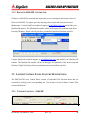
1
DISCOVER 4200-MP SIDE SCAN PROCESSOR SOFTWARE USER’S MANUAL Revision: 2.0 / February 2008 Email: [email protected] Web: http://www.EdgeTech.com 4 Little Brook Road West Wareham, MA 02576 Tel: (508) 291-0057 Fax: (508) 291-2492 141 Holland Drive, Suite 1 Boca Raton, FL 33487 Tel: (561) 995-7767 Fax: (561) 995-7761 DISCOVER 4200-MP PROCESSOR TABLE OF CONTENTS 1 - INTRODUCTION ............................................................................................................ 7 1.1 System Description ..................................................................................................... 7 1.2 High Definition and High Speed Modes..................................................................... 9 1.2.1 High Definition Mode (HDM) ........................................................................... 9 1.2.2 High Speed Mode (HSM)................................................................................... 9 1.3 Theory of Operation ................................................................................................. 10 1.3.1 Background....................................................................................................... 10 1.3.2 Transmit Signals............................................................................................... 14 1.3.3 Array configuration .......................................................................................... 14 1.3.4 Receiver processing.......................................................................................... 15 1.3.5 Range / Pulse / Bandwidth Coupling................................................................ 16 1.4 Remote Control Socket ............................................................................................. 17 2 - GENERAL DATA FLOWS........................................................................................... 19 2.1 key features............................................................................................................... 20 2.1.1 Data Sources..................................................................................................... 20 2.1.2 Recording of "raw" data ................................................................................... 20 2.1.3 Record while Playback ..................................................................................... 20 3 - SONAR CONTROLS..................................................................................................... 22 3.1 Menus ....................................................................................................................... 23 3.1.1 Configuration Menus........................................................................................ 23 3.1.1.1 Display Setup................................................................................................ 23 3.1.1.2 Record Setup ................................................................................................ 25 3.1.1.3 Printer Setup ................................................................................................. 26 3.1.1.4 Navigation Setup .......................................................................................... 28 3.1.1.5 Navigation Offsets:....................................................................................... 28 3.1.1.6 Target Logger ............................................................................................... 30 3.1.1.7 Triggering Options ....................................................................................... 30 3.1.1.8 Network ........................................................................................................ 32 3.1.1.9 Serial Ports.................................................................................................... 32 3.1.1.10 MultiPulse Calibration.............................................................................. 33 3.1.1.11 Layback .................................................................................................... 33 3.1.2 Control Menus .................................................................................................. 35 Document: 990-0000047-1000 Rev: 2.0 3 DISCOVER 4200-MP PROCESSOR 3.1.2.1 Advanced Sonar Controls............................................................................. 35 3.1.2.2 External Device Controls ............................................................................. 36 3.1.2.3 Diagnostic Information................................................................................. 36 3.1.2.4 XTF Controls................................................................................................ 39 3.1.3 Discover 4200-MP –restricted- ........................................................................ 40 3.2 Lower Control Panel Feature Descriptions ............................................................. 40 3.2.1 Towfish Control – 4200-MP ............................................................................ 40 3.2.2 Video Gains ...................................................................................................... 42 3.2.3 Display.............................................................................................................. 43 3.2.4 Disk................................................................................................................... 44 3.2.4.1 XTF Support:................................................................................................ 45 3.2.5 Bottom Tracking............................................................................................... 47 3.2.6 Grids ................................................................................................................. 48 3.2.7 Printer ............................................................................................................... 49 3.2.8 Status ................................................................................................................ 49 3.2.9 Signal................................................................................................................ 50 3.3 Lower Indicator Bar Feature Descriptions.............................................................. 50 3.4 Shortcut Bar.............................................................................................................. 51 3.5 Screen Clicks and Other Shortcuts........................................................................... 51 3.5.1 Bottom Tracking............................................................................................... 51 3.5.2 Zoom................................................................................................................. 53 4 - NAVIGATION & ANNOTATION INTERFACE ...................................................... 55 4.1 NMEA Approved Sentence Structure........................................................................ 55 4.2 Port Parameters ....................................................................................................... 56 4.3 Port Selection ........................................................................................................... 56 4.4 Inputs ........................................................................................................................ 57 4.4.1 GLL – Geographic Position – Latitude/Longitude........................................... 57 4.4.2 GXY-Geographic Position-X and Y Coordinates ............................................ 57 4.4.3 GGU - Geographic Position - X and Y Coordinates ........................................ 58 4.4.4 GGA – Global Positioning System Fix Data.................................................... 58 4.4.5 RMA – Recommended Minimum Specific Loran-C data................................ 59 4.4.6 RMC – Recommended Minimum Specific GNSS Data .................................. 59 4.4.7 VTG – Track Made Good and Ground Speed.................................................. 59 4.4.8 ZDA - Time & Date ......................................................................................... 59 4.4.9 HDG - Heading, Deviation and Variation........................................................ 60 4.4.10 EVT - Event & Annotation (EdgeTech custom) .............................................. 61 4.4.11 EMA - Event, Set Mark, and Annotation (EdgeTech custom)......................... 61 4.5 Serial Port Connections ........................................................................................... 62 4.6 Troubleshooting........................................................................................................ 63 Document: 990-0000047-1000 Rev: 2.0 4 DISCOVER 4200-MP PROCESSOR 5 - COVERAGE MAPPER................................................................................................. 66 5.1 Introduction .............................................................................................................. 66 5.2 Operation.................................................................................................................. 69 5.2.1 Window Layout ................................................................................................ 70 5.2.2 Control Icons: Left to Right ............................................................................ 70 5.2.3 File Menu.......................................................................................................... 71 5.2.4 Configuration Men ........................................................................................... 72 5.2.5 View ................................................................................................................. 72 6 - TARGET LOGGER....................................................................................................... 74 6.1 Introduction .............................................................................................................. 74 6.2 Operation.................................................................................................................. 74 6.2.1 Window Layout ................................................................................................ 75 6.3 File Menu.................................................................................................................. 76 6.4 Configuration Menu ................................................................................................. 77 6.4.1 Target Settings.................................................................................................. 77 6.4.2 Log File Configuration ..................................................................................... 78 6.4.3 Navigation Overrides........................................................................................ 80 6.4.4 Maptech® Mark file Format............................................................................ 80 6.4.5 Log File Format ................................................................................................ 80 6.4.5.1 Default File................................................................................................... 81 6.4.5.2 All Fields ...................................................................................................... 81 6.5 View Menu ................................................................................................................ 82 6.5.1 Target Information............................................................................................ 82 6.5.2 Measurements................................................................................................... 83 6.5.3 Navigation Offsets............................................................................................ 84 6.6 Icons on the Taskbar ................................................................................................ 85 6.7 Target Image ............................................................................................................ 87 6.8 Bottom Tracking ....................................................................................................... 87 6.9 Remarks Field........................................................................................................... 87 6.10 Target Candidates .................................................................................................... 88 6.11 HTM File Output ...................................................................................................... 88 7 - CALIBRATION ............................................................................................................. 89 8 - OVERLOAD ................................................................................................................... 93 9 - COMPASS CALIBRATION......................................................................................... 94 Document: 990-0000047-1000 Rev: 2.0 5 DISCOVER 4200-MP PROCESSOR 9.1 Calibration Method .................................................................................................. 94 10 - CUSTOMER SERVICE ................................................................................................ 98 10.1 Statement .................................................................................................................. 98 10.2 Returned Material Authorization ............................................................................. 99 Document: 990-0000047-1000 Rev: 2.0 6 DISCOVER 4200-MP PROCESSOR 1 - INTRODUCTION This manual describes the operation of EdgeTech’s Discover side scan acquisition software, as configured for the 4200-MP series side scan sonar. The Discover software is also used in slightly different configurations to support other EdgeTech side scan and Sub-bottom sonar products, with a great deal of commonality in functionality and appearance. The end user benefits flow directly from this common approach. One key element of commonality is a standardized Ethernet based input /output for sonar data. 1.1 SYSTEM DESCRIPTION The EdgeTech Discover based 4200-MP topside processor may be used with 2 possible system configurations: 1. Using a 4200 “Rack mount” Topside 2. Using a 4200P “Portable” Topside In the 4200P "portable" configuration, the towfish power supply, and digital telemetry system are housed in a watertight plastic carry case. Connection to the Discover Processor (usually a Laptop style PC) is made through an ETHERNET cable or wireless LAN. In the 4200 configuration, the processor houses the display and acquisition processing hardware and software. The towfish power supply and telemetry system are housed in a 19" rack. Both configurations use a single wire (nominally co-axial) tow cable. Navigation and auxiliary inputs are all made to this common processor. Document: 990-0000047-1000 Rev: 2.0 7 DISCOVER 4200-MP PROCESSOR The software environment for these 2 cases is shown in the diagrams below. Model 4200 Rack Mount Topside Processor with EdgeTech DISCOVER Software Tow cable Ethernet 4150 Towfish Network address = 192.9.0.101 Rack Mount Configuration Model 4200 Portable Topside Processor with EdgeTech DISCOVER Software Tow Cable Ethernet 4150 Towfish Portable Configuration Document: 990-0000047-1000 Rev: 2.0 8 DISCOVER 4200-MP PROCESSOR 1.2 HIGH DEFINITION AND HIGH SPEED MODES The 4200-MP series sonar is unique in its ability to provide both high speed and high definition modes of operation. The mode chosen will depend on the users task at hand, and tow speed requirements. 1.2.1 HIGH DEFINITION MODE (HDM) In the HDM mode, the system performs as a conventional, simultaneous dual frequency side scan sonar, using linear FM chirp pulses for improved range and signal to noise ratio operation. The system’s array elements are configured and utilized to provide the best along track resolution of the system. The maximum tow speed of the system is proportional to the conventional sonar update rate. This update rate is in turn relative to the time it takes for the transmitted signal to travel from the tow fish to the maximum range and back again. This “ping rate" is what sets the maximum tow speed, given a user requirement for "hits on target". The 4150-FS System has a maximum tow speed of 4.8 knots and meets the NOAA Shallow Water Survey Specification of three pings on a one meter target at 100 meters range. The system may be operated as a single frequency system, or as a simultaneous dual frequency system. Independent range operation for the 2 frequencies is also provided. See Section 2. 1.2.2 HIGH SPEED MODE (HSM) In the HSM mode, use is made of the EdgeTech MultiPulse technique to provide for doubling the update rate of the sonar. This allows twice the tow speed, given the same constraint for "hits on target". See Section 1.3 below. In this mode the system's array elements are re-configured to provide a transmit-while-receive capability, and a small penalty is paid in along track resolution. At high tow speeds (8 knots), this is more than compensated for by the higher update rate of the system, with a much improved Document: 990-0000047-1000 Rev: 2.0 9 DISCOVER 4200-MP PROCESSOR image, allowing for better detection and classification than conventional side scan sonar at these speeds. In the HSM mode, ONLY one frequency may be operated at any one time. 1.3 THEORY OF OPERATION This section details the underlying theory and principles of the MultiPulse operation of the MP-X ® sonar. The same principles apply to the 4200-MP series, when operated in High Definition Mode with the restriction that a maximum of 2 pulses may be used, and the technique is extended to both the 410 KHz and 120Khz channels of the 4200MP.. 1.3.1 BACKGROUND Conventional side scan sonar (SS) system has a maximum tow speed, Vmax, if it is desired not to miss any area of the sea floor. The following diagram indicates the array and beam positions when this condition is reached. R d Critical Speed = Vmax In this case the array displacement per ping (d) is approximately the arrays' acoustic length. A typical array length for 500Khz SS systems with 0.8 degree beamwidth is 20cms. The ping cycle time for such a system is: t1p = 2*R/C (1) Document: 990-0000047-1000 Rev: 2.0 10 DISCOVER 4200-MP PROCESSOR where C is the speed of sound, nominally 1500m/s. For such a system the maximum displacement per ping is : d = v1p*t1p (2) where v1p is the maximum tow speed. Thus v1p = d *C / (2R) (3) = 0.2 *1500/(2*100) = 1.5m/s = 3 knots (approx) If this speed is exceeded the beam diagram will be as below. Missed target area Above Critical Speed The maximum tow speed limit may, alternatively, be specified by the survey requirement, where it is typical to specify a minimum "number of hits" on a target to ensure suitable probability of detection. Then v = L * C/2 * 1.94 / (R * H) (4) where: L = Target size H = hits on target R = range in meters Document: 990-0000047-1000 Rev: 2.0 11 DISCOVER 4200-MP PROCESSOR v = speed in knots For this condition, v = 4.8 knots for a 1 meter target at 100m range scale for 3 hits on target, which is a common NOAA survey requirement. See: http://usace.army.mil/inet/usace-docs/eng-manuals/em1110-2-1003/c-12.pdf The maximum speed allowed for 150m range is 3.2 knots. The tow speed may be increased, in both cases, if the effective ping repetition rate of the sonar could be increased, independent of the range setting. This is accomplished in the MP-X sonar by transmitting multiple, distinct pulses at a higher rate than dictated by t1p, (Equation 1). The beam diagram for a MP-X using 4 pulses is: Direction of travel Pulse =A Pulse =D Pulse =C Pulse =B Pulse =A Multi pulse fill in The timing diagram for the transmit and receive functions is shown below. Document: 990-0000047-1000 Rev: 2.0 12 DISCOVER 4200-MP PROCESSOR Range Scale = Rmax T = (2*Rmax)/C T x A T x A Rx A Period t T x B T x B Rx B Period t t = (2*Rmax) 4*C T x C Rx C Period t T x D Rx D Period T x C T x D t The tow speed limit is now increased fourfold, so that Equation 4 becomes vmp = M *L * C/2 * 1.94 / (R * H) (5) where: M = number of pulses. The NOAA requirement for "3 hits on a 1m target" at the 150m range setting is now exceeded at 12knots. It is important to note that the pulse timing is evenly distributed in time, and the effective scrolling rate of the MP-X sonar is increased by the number of pulses employed. Any speed increase or decrease simply results in image stretching exactly as it does for standard one pulse systems. Any deviations from a straight line path do not affect the image any more than they do a standard system, and provided accurate heading information is logged, may be properly compensated for during image mosaicing. Furthermore, unlike the multibeam approach, tow speed or bottom speed input is not required at any time for the basic image formation. Speed input is required only if the image is to be speed corrected. Document: 990-0000047-1000 Rev: 2.0 13 DISCOVER 4200-MP PROCESSOR 1.3.2 TRANSMIT SIGNALS MP-X transmit signal are linear frequency modulated (FM) "chirp" pulses, with near gaussian amplitude weighting. The inter pulse discrimination/rejection required is achieved by constraining the energy for each pulse to unique non overlapping frequency bands. The total bandwidth available for the pulses is limited by the array's combined transmit/receive (tx/rx) sensitivity. Figure 5 indicates the pulse bandwidth allocation for 2 pulses. The center frequency of the array's combined Tx/Rx response is at f0. The available spectrum is evenly divided between the 2 pulses A and B with minimal guard band separation. The pulse energy must be constrained to lie inside the desired regions A and B, but there will be some leakage or sidelobe levels as shown in the diagram. These are kept to a very low level by using suitable pulse shaping. Transmit Pulse Frequency Content, 2 pulses Useful Array bandwidth B A Frequency guardband f0 A 4-pulse frequency allocation is shown in Figure 6. 1.3.3 ARRAY CONFIGURATION The difference between the transmit voltage and the received echo levels in a system using piezo-electric transducer elements is very large. Typical transmit levels may be several hundred volts or more, while the receive signals are in the micro-volt region. It Document: 990-0000047-1000 Rev: 2.0 14 DISCOVER 4200-MP PROCESSOR is not possible therefore to share the same piezo-electric elements for these functions as is common in most side scan sonar systems. The MP-X sonar uses a separate element for each of the transmit and receive functions, all contained within one physical array construction, with careful attention to acoustic isolation within the array. Pulse Generator Pulse A&B Pwr Amp Fwd Direction Tx Element Rx element Reciever Amplifier 1.3.4 RECEIVER PROCESSING The essential elements of the receiver processing are shown in the figure below: Document: 990-0000047-1000 Rev: 2.0 15 DISCOVER 4200-MP PROCESSOR Rx element Pre Amp BandPass Normal Rx Period T t0 pulse A MF A A/D MF B t0 pulse B The echo signals from the receive element are amplified and band-limited to encompass the useable array bandwidth. After suitable amplification, the combined echo signals are digitized with one high dynamic range A/D converter. It is important to realize that the echoes being received at any instant may come from up to 4 different ranges, one from each transmitted pulse, ensonifying different areas of the sea floor. The inter pulse discrimination and echo separation is achieved in the FM (chirp) matched filtering. For each transmitted pulse, A, B and C or D, a corresponding matched filter (MF) is implemented in digital signal processing (DSP), where the echo data is digitally correlated with a replica of the transmit signal. The chirp waveform processing provides both signal gain during compression, and the required inter pulse discrimination. 1.3.5 RANGE / PULSE / BANDWIDTH COUPLING At short ranges, the ping (or firing) rate of the sonar is naturally very high. For example at 25m range the ping rate is about 1500 / 2 / 25 = 30/second. As the range is increased, the ping rate for a single pulse system drops linearly to about 5/second at 150m. It is here where the MP-X's multiple pulses can be best employed. For a 4pulse mode the ping rate can be restored to 20/s. As shown in Section 1.3.2, these multiple pulses are achieved by utilizing LESS bandwidth per pulse, so that the total array bandwidth available is divided equally among the 4 pulses. Document: 990-0000047-1000 Rev: 2.0 16 DISCOVER 4200-MP PROCESSOR It is a natural consequence then, that using more pulses reduces the across track resolution, and explains partially why using the maximum number of pulses (4) is not always the best choice. However, this situation also arises in all other side scan sonars. Take for example the conventional (non chirped) CW (continuous wave) sonar, where for longer range operation, a longer pulse is used, normally to emit more energy. A natural consequence of this is reduced range resolution since range resolution ( rr) is proportional to pulse length (t) rr = C *t 2 This longer pulse also has narrower bandwidth so the full available bandwidth is NOT being used. The MP-X has the advantage of always fully utilizing the available system bandwidth. At long ranges this bandwidth is exploited to achieve a higher update rate, exactly when it is needed. In general the following "rule of thumb" is valid: "At shorter ranges, fewer pulses with higher bandwidth are used, and at longer ranges, more pulses with lower bandwidth should be used. " This can be further modified by considering the tow speed. If the tow speed for the survey is going to be very fast, i.e > 8-10knots) then the image will be greatly enhanced by employing more pulses (4) albeit with less bandwidth. However, if the survey will be conducted at slows speeds, i.e < 4 knots, then the image will be better using less pulses but with more bandwidth, e.g. 2. pulses. 1.4 REMOTE CONTROL SOCKET The system may be optionally controlled in a limited manner (On/OFF, Range selection), and data recorded by 3rd party Topside controller systems. This is accomplished via a second dedicated Ethernet port on the Discover processor. These 3 rd party systems are available from Triton Elics International, (ISIS®, see: www.tritonelics.com ) and CodaOctopus Ltd. Document: 990-0000047-1000 Rev: 2.0 17 DISCOVER 4200-MP PROCESSOR (Coda GeoSurvey, See www.CodaOctopus.com.). These systems provide advanced survey functionality such as real-time mosaics, and pipeline tracking. Document: 990-0000047-1000 Rev: 2.0 18 DISCOVER 4200-MP PROCESSOR 2 - GENERAL DATA FLOWS The flow diagram below shows the general processing concepts and data flows associated with the Discover Acquisition software. User Inputs Gain TVG Pallete Balance Zoom User Inputs Range Set Pulse Select Power Set G Tow Fish Interface TCP/IP Source n ai Display Processing TVG,Gain,Palette Acquire/ Input Data Record Processing (XTF) Playback data Disk Store Disk Store Record Processing (JSF) Nav Input Processing Direct to Display Display Com Port Primary Data Flow Record/Playback Discover Processing Diagram Document: 990-0000047-1000 Rev: 2.0 19 DISCOVER 4200-MP PROCESSOR 2.1 KEY FEATURES 2.1.1 DATA SOURCES All data and command interfaces with the sonar sub-system are implemented using TCP/IP (Transport Control Protocol/Internet Protocol). The source for Navigation (and other auxiliary data) is via serial ports on the processor. 2.1.2 RECORDING OF "RAW" DATA To the fullest extent possible, the data received from the sonar system is recorded to disk in the native EdgeTech format ".jsf " without any of the user's run time displayprocessing options applied, such as screen gain, software TVG etc. The only User settings which unavoidably affect the recorded data are those implemented by the sonar system, such as range settings, pulse power levels and pulse selection. This is only true for native format recorded data which supports a floating exponent format. For those post processing packages that do not support the new version 18 of XTF, the user's Gain setting must be applied to the data before fixing and truncating the data to 16 bits. Other valuable system setting information is also lost, which may be valuable for later system error diagnosis. 2.1.3 RECORD WHILE PLAYBACK The independent operation of the playback and recording modules of the Discover software allow some very useful data operations. 1) During real-time data acquisition, only the record module is available. This may be engaged to log data in native JSF format or XTF format. This may be started, paused or stopped at anytime during acquisition. 2) During Playback, the record operation may be started, paused and stopped at any time. 3) During Recording, the Playback operation may be started, paused and stopped at any time. The data file source for playback may also be changed. Document: 990-0000047-1000 Rev: 2.0 20 DISCOVER 4200-MP PROCESSOR 4) When recording to a file the format may be specified to be either native JSF or XTF format. This allows for transcription of JSF file to XTF format at any time. The reverse is NOT true. For this reason we recommend that all data is acquired and archived on the native JSF format, as nothing is lost during record. Items 2) and 3) above allow the user to concatenate (join together) several input files into one output file, and also to "snip" a section out of an input file to make shorter output file. Notes: - When recording in XTF, Discover automatically records in JSF as well. - XTF flies can not be played back on Discover. Document: 990-0000047-1000 Rev: 2.0 21 DISCOVER 4200-MP PROCESSOR 3 - SONAR CONTROLS This document describes the DISCOVER™ Software features and operation. The Discover Software is a Side Scan Sonar Digital Data Acquisition program The Discover Software is designed to have a very easy to operate graphical user interface: Upper Menu bar Upper Shortcut Port HF Signal Amplitude Display Stbd HF Signal Amplitude Display Port High Freq Display Window Stbd High Freq Display Window Port LF Signal Amplitude Display Stbd LF Signal Amplitude Display Port Low Freq Display Window Stbd Low Freq Display Window Lower Control Panels Document: 990-0000047-1000 Lower Status Bar Rev: 2.0 22 DISCOVER 4200-MP PROCESSOR The main display window area is split into four resizable sub windows. Each displays High or Low frequency, Port (left side) or Starboard (right side) waterfall data. When only one system is active, only that sub-systems window is shown, maximizing the area available. 3.1 MENUS The Discover Configuration Settings and other Controls are accessible by selecting the pull down menus at the top of the screen marked “Configuration” and Control respectively. 3.1.1 CONFIGURATION MENUS The Configuration pull down sub menu is shown above. NOTE: Not all Discover versions implement every feature described herein. If an item is not applicable to all versions, this is noted as a footnote to each control. Each sub menu item is described below. 3.1.1.1 Display Setup Document: 990-0000047-1000 Rev: 2.0 23 DISCOVER 4200-MP PROCESSOR TVG START [Toggle]: This selection allows the user to select the starting point of the Time Varied Gain (TVG). The TVG can be applied beginning at the towfish (“origin”) or seafloor. The seafloor location is determined by the bottom tracking. In order for the Sea Floor setting to be used the software must be bottom tracking reliably. Recommended setting = Origin. SLANT RANGE CORRECTION ON [Check Box]: This selection allows the user to toggle the slant range correction on/off separately for the high and low frequencies. In order for the data to be slant range corrected the software must be bottom tracking reliably. If checked, the sea floor altitude from the bottom tracking feature is used to convert the standard slant range sidescan data to a ground range data using a flat bottom assumption. The bottom track data may be overridden using the Manual entry box and checking the Override option. SPEED CORRECTION ON [Check Box]: This selection allows the user to toggle the speed correction on/off separately for the high and low frequencies. A speed corrected image is adjusted in the along track dimension to make the vertical display pixel cover the same length of ground as the CURRENT across (horizontal) track pixel size to present a geometrically correct image. i.e. square objects should appear square in the image. Consequently, changing the across track ZOOM factor will automatically affect the vertical display zoom. In order for the data to be speed corrected the system must be receiving a valid GPS (NMEA) input for speed over the ground or using manual speed override. SUBSAMPLE METHOD [Drop Down Menu]: This selection allows the user to choose separately for each the high and low frequencies, which Subsample Method being used. Maximum is recommended. TEMPERATURE SOURCE [Toggle]: This selection allows the user to choose the source of the temperature data. There are two places where the temperature can be measured, the first being the wall of the bottle, this gives the water temperature. And the second giving the ambient temperature inside the bottle (the electronics). SOUND SPEED [Numeric Display, Entry]: This selection allows the user to adjust the sound speed in water. Adjusting the Speed of Sound will affect the range scale and size Document: 990-0000047-1000 Rev: 2.0 24 DISCOVER 4200-MP PROCESSOR dimensions. Unless you have an accurate measurement of the sound speed then this value should remain at the default value of 1500m/sec. MANUAL ALTITUDE [M]: This feature allows the user to manually force the Slant Range correction to use a certain fish altitude. In order to make the software accept the new value you must enable the override selection box. This feature is not recommended for use during real-time data acquisition. This feature is best used during playback in areas where it is difficult to automatically bottom track due to soft seafloor materials or suspended sediments in the water. MANUAL SPEED [Kn]: This feature allows the user to manually force the towfish speed to a certain value. In order to make the software accept the new value you must enable the override selection box. This feature is not recommended for use during real-time data acquisition. This feature is best used during playback on data that lacks the proper speed input from the navigation system. This value affects the image only when speed correction is enabled. 3.1.1.2 Record Setup MAXIMUM FILE SIZE (MB): This selection allows the user to set the maximum size of the recorded data file. When the maximum file size is reached the software will automatically close the current file and open another file with a 001, 002, 003 etc appended to the end of the file name. This feature is very useful for breaking long survey lines into small easily managed data files. Setting a size greater than 600 MB may prevent the resulting files from being copied onto CD-ROM disks. FREE DISK SPACE WARNING (MB): This selection allows the user to set a minimum limit for the disk space warning indicator. This indicator will alert the operator when the available disk space is approaching zero (disk is nearly full). Default value is 10 Megabytes. Document: 990-0000047-1000 Rev: 2.0 25 DISCOVER 4200-MP PROCESSOR XTF OUTPUT [CHECK BOX]: Checking this box will force the data Recording subsystem to produce an XTF (eXtended Triton Format) format output, in addition to the native jsf format. See also: Section 3.1.2.4. 3.1.1.3 Printer Setup Note: Printing is not supported on the 4200P portable topside. This configuration window is for selecting one of the supported thermal printers. Currently the following printers are supported: • Ultra 120 (and HD version) • Ultra 200 (and HD version) • EPC HSP 100 • EPC 1086-NT • EPC 1086 • EPC 1086 (early models) • EPC 9206 • TDU-850 • ISys V8.5 • GeoPrinter 975 INVERT PRINT [Toggle]: This selection allows the user to mirror the sidescan data on the printout. This will flip the port and starboard channel positions on the paper. Use to get the correct orientation for your installation. Document: 990-0000047-1000 Rev: 2.0 26 DISCOVER 4200-MP PROCESSOR INVERT GRAYSCALE [Toggle]: This selection allows the user to select dark output for low back scatter areas. SLANT RANGE CORRECTION [Toggle]: This selection allows the user to correct for slant control during printing. ACTIVE BANNER [Toggle]: This selection allows the user to show the banner at the footer of the data record on the printout. REVERSE BANNER [Toggle]: This selection allows the user to mirror the banner at the footer of the data record on the printout. Depending on the orientation of the printer, you may need to select this option. Note: Invert Print and Reverse Banner work together to select the orientation of the data printout. DEPTH SCALE [Toggle]: This selection allows the user to: • ACTIVE –Activates the Depth Scale on the printout. • LABELS – Toggles on/off the Labels on the printout. • BACKGROUND – Toggles on/off background of the depth scale on the printout. • INVERT SHADE – When selected inverts the shade of depth scale on the printout. ANNOTATION [Toggle]: This selection allows the user to: • ACTIVE – Activates the annotation on the printout. • TEXT – Toggles on/off the annotation text on the printout. • EVENT NUMBER – Toggles on/off the event number on the printout. • BACKGROUND – Toggles on/off background of the annotation on the printout. • INVERT SHADE – When selected inverts the shade of annotation on the printout. Document: 990-0000047-1000 Rev: 2.0 27 DISCOVER 4200-MP PROCESSOR PORT [Drop Down Menu]: This selection allows the user to select the proper printer interface. 3.1.1.4 Navigation Setup See also Navigation Interface Section BAUD RATE: This selection allows the user to select the navigation input port baud rate. The default is 4800. Serial Port Selection is made through settings in the Discover_Defaults.jni, DiscoverLast4200-MP.Jni or other *.jni file. Note: The large window in the middle of the navigation Configuration panel will display the last valid NMEA 0183 message that the Discover Software detected. Using the scroll down option will show more messages. 3.1.1.5 Navigation Offsets: Navigation Offsets are used only for target location determination using the Target Logger. These values are NOT recorded with the data, only the raw navigation data from the GPS or Navigation Interface such as Hypack® is recorded to disk. The navigation information displayed in the Status Tab is the raw navigation information. There are 3 sets of Fixed Offsets: One related to the position of the towfish versus the GPS antenna, one related to Hull mounted systems and one when raw navigation information is known to have errors. Document: 990-0000047-1000 Rev: 2.0 28 DISCOVER 4200-MP PROCESSOR Note: The operator should log the Navigation Offsets and insert them every time the data is being played back. SENSOR DISPLACMENT AFT OFFSET (M): This selection box allows the user to enter a layback distance value for the towfish. A towfish attached to the bow of the vessel will have negative value. This info is also recorded with the XTF. Note this information is very important if the Discover Coverage Mapper application is being used. STARBOARD OFFSET (M): This selection box allows the user to enter a fixed distance value for the towfish. A towfish towing from the port side of the vessel will have negative value HEADING OFFSET (DEGREE): This selection box allows the user to enter a fixed offset for the heading information coming from the towfish. (Such as to correct for magnetic variation to get a true north estimate) DEPTH OFFSET (UP IS NEGATIVE): This selection box allows the user to enter a fixed offset for the towfish depth. HULL MOUNT ADJUSTMENT In hull mount configuration the towfish Pitch and Roll information needs to be corrected to the Pitch and Roll of the survey vessel to account for lever effect, hence the need to make some adjustments. PITCH OFFSET (NOSE UP IS POSITIVE): This selection box allows the user to enter a fixed offset for the pitch information coming from the towfish. ROLL OFFSET (PORT SIDE UP IS POSITIVE): This selection box allows the user to enter a fixed offset for the roll information coming from the towfish. Document: 990-0000047-1000 Rev: 2.0 29 DISCOVER 4200-MP PROCESSOR INPUT NAVIGATION CORRECTIONS Depending of the type of input navigation, UTM or Lat/Long, either the X & Y field or the Lat/Long fields need adjustment for known errors in the raw navigation input. X OFFSET (M): This selection box allows the user to enter a fixed offset for the Easting information. Y OFFSET (M): This selection box allows the user to enter a fixed offset for the Northing information. LATITUDE OFFSET (DEGREE): This selection box allows the user to enter a fixed offset for the latitude information. LONGITUDE OFFSET (DEGREE): This selection box allows the user to enter a fixed offset for the longitude information. 3.1.1.6 Target Logger If this box is checked, then a mouse RIGHT click on the scrolling display window will invoke the Target Logger application, and transfer the selected region to the Target Logger for measurements and analysis. See Section:5 Target Logger. 3.1.1.7 Triggering Options The 4200-MP system supports either single frequency or simultaneous dual frequency operation. Document: 990-0000047-1000 Rev: 2.0 30 DISCOVER 4200-MP PROCESSOR In the simultaneous dual frequency mode, the 2 systems must be arranged to transmit at the same time to minimize inter-system interference. This menu control allows this as follows: Trigger Master Selection: • Sidescan High. If selected, this will allow the system to automatically trigger itself at the maximum rate allowed by the Sidescan High system range setting. The Low Frequency system will run at this rate, OR an integer sub multiple of this rate, using the Divisor setting. Example 1: Sidescan High range = 100m. Ping Rate = 7.5 / second. Sidescan Low (SSL) Range = 200m, Ping Rate = 3.75/s with Trigger Divisor = 2 in this case there may be some interference at 100m in the SSL record, when the SSH system fires. Example 2: Sidescan high = 50m, Ping rate = 15/sec, SidescanLow = 100m, Divisor = 1. The SSL will fire at 15/sec, and will only display 50m of data. • Sidescan Low. If selected, the system will automatically trigger itself at the maximum rate allowed by the Sidescan Low range setting. The Sidescan high (SSH) subsystem will trigger at this rate as well, since the SSH range is normally less than the SSL range. There will now be no interference between systems, but the SSH system will run slowly. • External: If selected the system will ONLY trigger itself in the event of an externally supplied trigger signal. The external trigger is user supplied at the "topside" via the Telemetry interface. NOTE: If selected, the system WILL NOT RUN unless there is a valid external input. If only one subsystem is active (high or low) the selection of Sidescan High or Sidescan Low as the master system will have no effect, and the system will run at the supported range rate. EXTERNIAL DELAY (ms): This allows the external trigger event to be delayed by this amount with respect to the trigger event. INTERNAL DIVISOR: If set to 1, the subsystem will fire once for every internal trigger event. The maximum range the system can achieve is thus set by the trigger rate. If set to 2, a Document: 990-0000047-1000 Rev: 2.0 31 DISCOVER 4200-MP PROCESSOR longer range may be digitized as the sub-system will now fire once for every 2 trigger events. This is true for higher divisors. This is true for subsystem and external trigger selections. EXTERNAL DIVISOR: If set to 1, the subsystem will fire once for every external trigger event. The maximum range the system can achieve is thus set by the trigger rate. If set to 2, a longer range may be digitized as the sub-system will now fire once for every 2 trigger events. This is true for higher divisors. This is true for subsystem and external trigger selections. 3.1.1.8 Network This dialog allows the user to change the IP (internet protocol) address and control port of the towfish. DO NOT change this parameter unless a corresponding change has been made to the towfish subsystem. This should only be done in truly exceptional circumstances, by expert users or system administrators. 3.1.1.9 Serial Ports This menu allows the user to configure the serial ports and adjust relative baud rates for the primary and secondary navigation inputs and also the cable counter monitoring. Discover allows for two separate Navigation Devices coming in on different serial ports. Remote COM Document: 990-0000047-1000 Rev: 2.0 32 DISCOVER 4200-MP PROCESSOR ports give the user the ability to link a serial device in the bottle to Discover via the telemetry link. 3.1.1.10 MultiPulse Calibration This is applicable to the MP-X (4300) and 4200-MP versions only. See Section: 7Calibration. 3.1.1.11 Layback Layback is the horizontal distance (in meters) from a reference on the survey vessel to the towfish. The layback function is for tracking the sonar towfish, this is done by inputting or calculating the offsets of the towfish. Depending on the available sensors the surveyor may choose one of three methods for calculating the layback. 1. manually 2. using the hypotenuse equation 3. using a catenary factor Notes: • Sonar data collected with will layback will have the layback values permanently stored in the JSF file. • Layback information can be modified during playback to generate corrected maps. • Layback values entered during playback do not override the existing numbers. • All values entered in this menu are expected to be in meters. • During playback the software defaults to playing back the data without any layback. Document: 990-0000047-1000 Rev: 2.0 33 DISCOVER 4200-MP PROCESSOR • To use the originally recorded layback values customer must select playback form the drop down menu in ‘layback calculations’. • The Catenary value is expected to be between 0 and 1; with 0 representing the towfish directly below towpoint and 1 representing the angle of attack to be zero degrees (horizontal). • For exact layback reading a USBL (Ultra-short baseline, a method of underwater acoustic positioning) is required. Figure 3.1 Layback Cable Out Towfish Depth Towpoint Offsets Layback Calculations Manual User manually inputs the estimated amount of cable out. MacArtney The cable out comes in through a serial port to (counter) Discover from a counter on the winch. Playback Originally calculated cable out value is used Manual User manually inputs the estimated depth of the towfish. Pressure Depth comes in through a serial port to Discover from a Sensor pressure sensor in the towfish. $-DPT Depth comes in as a NMEA string through a serial port to Discover from a pressure sensor in the towfish. The format expected is $--DPT,x.x,x.x,x.x*hh<CR><LF> Playback Originally calculated towfish depth value is used This is the offset (distance in meters) from the GPS to the tow point manually inputted by user. Note: height should be from sea level. Manual The user manually inputs the estimated layback and that value is used by Discover Hypotenuse Using the equation that Layback equals the square root of the difference between the square of the cable out and the square of the sum of the depth and towpoint height. L = C − ( d + h ) 2 Catenary Playback Document: 990-0000047-1000 2 Layback equals the line out times the catenary factor (angle of attack) Originally calculated layback value is used Rev: 2.0 34 DISCOVER 4200-MP PROCESSOR Warning: Layback calculations are set up for surveys preformed in a straight line. When turning layback calculations are not valid. 3.1.2 CONTROL MENUS The Control menus provide access to more advanced features not commonly used in the software. 3.1.2.1 Advanced Sonar Controls This pull down menu option allows access to the transmit Power Level controls. POWER LEVEL [%] : This allows the transmit power to be reduced in those circumstances where the full power setting (100%) overloads the receivers, typically when running very close to a hard seabed. Useful range for the control is typically 50 to 100%. The Power Level warning indicator (Lower Indicator Bar) will turn RED when the power is NOT 100%. This should only be used if you are sure that the transmit pulse amplitudes are too high and are overloading the receiver. Document: 990-0000047-1000 Rev: 2.0 35 DISCOVER 4200-MP PROCESSOR 3.1.2.2 External Device Controls Allows control over external devices. 3.1.2.3 Diagnostic Information This Status window shows the state of the connection between the Discover application and the sonar unit being controlled. The display shown below is for a 4200-MP system. The state of the telemetry link is shown to the left. Here the system is fully operational with no problems. The connection to the towfish is good, the cable current is reported to be 97mA (good values are between 80 to 180mA for a 4200MP towfish). Other reported data are : • Power (V) : nominally 48VDC. This is the primary internal supply voltage for the towfish and should be between 44 to 52 VDC. • Ambient ( C) : This is the internal ambient temperature of the towfish. This shold be between 0 and 60deg C max. A value of 65C and over will prevent correct towfish operation. • Bottle ( C) : Not used. Document: 990-0000047-1000 Rev: 2.0 36 DISCOVER 4200-MP PROCESSOR • Error Count: A non zero value is O,K but it should NOT BE INCREASING during normal operation. If it is it indicates and internal software error or an inadequate telemetry uplink rate. • Activity: Shows CPU activity counter. has no specific meaning but should be steadily increasing. • Surface ( C): This is the ambient temperature of the topside interface electronics. • Supervisor: Not used. Here are some other diagnostic displays with some errors. In this case the software communication between the topside and the towfish has been lost. (no TCP/IP PING connectivity). The Cable Current is reported as 97mA (Normal) so the towfish is attached to the cable and drawing normal power. This indicates either a telemetry problem, possibly due to cable noise, excessive length or signal attentuation, or possibly a complete failure of the towfish computer to boot properly. Sometime a power cycle of the topside interface unit will correct this error. Document: 990-0000047-1000 Rev: 2.0 37 DISCOVER 4200-MP PROCESSOR This case looks very similar to the previous case, but there is one crucial difference: The cable current is excessively low (2mA), and the system reports (lower left) that the Fish power has been Turned Off as the cable current was detected to be undercurrent. For safety, at all times the cable current is continuously monitored, and if detected to be too low (cable disconnected) or too high (cable loose in the water) the power is automatically turned off. To help determine the cause of the power OFF state, the system will report either Under or Over current as the reason. The Diagnostics message reported in the Top Right section (in RED if a problem is detected) is a vita clue for diagnosing connectivity problems. Possible sates for this are: 1) Network Configuration Error 2) Cannot Ping Towfish Electronics 3) No Socket Connection The system level diagnosis for each State is: 1) Network Configuration Error: The Towfish and telemetry system are not powered on, or the Ethernet connection between the Discover computer and the telemetry system is not correct. This error is reported if there is no valid Ethernet connection at the Discover computer on the TCP/IP 192.9.0.xxx subnet. ( a Ping command to this connection will return the Windows message: Hardware Error.) 2) Cannot Ping Towfish Electronics: The ADSL link between the telemetry system and the towfish is not established OR the towfish computer has not booted. These can both take take about 1 minute and 20 seconds after power on to be established. Document: 990-0000047-1000 Rev: 2.0 38 DISCOVER 4200-MP PROCESSOR 3) The ADSL link is up and correct but the sonar application in the towfish is not running correctly. This connection should be established about 1min 30 seconds after towfish power on. 3.1.2.4 XTF Controls This Dialog window provides user control over the production of the XTF recorded data for both the high and low frequency, (if it is enabled, See 0). USE DISPLAY GAINS [Check Box]: The XTF file format only supports 16 bit data, whereas the native EdgeTech format (*.JSF) is 16 bits with a block floating scale factor for each ping and supports much higher dynamic range data. Consequently the data must be scaled to an absolute 16-bit number before recording in XTf format. It is normal to leave this box checked and use the current display gains so the XTF file is WYSIWYG (what you see is what you get). However in some circumstances it may be desirable not to let user applied gain changes affect the recorded data, in which case this should be unchecked and the desired fixed gain can be applied. GAIN [dB]: The user specified gain is applied to the JSF format data before being truncated to fixed 16 bit values and written to the XTF file. STARBOARD GAIN [dB]: A gain offset ( + or - ) maybe applied to correct for port / starboard imbalances. (Normally = 0). NEWFILE ON RANGE CHANGE [Check Box]: The generation of a new file can be forced on a range scale change by checking this box. This ensures the production of XTF files without any range scale changes inside the file. Document: 990-0000047-1000 Rev: 2.0 39 DISCOVER 4200-MP PROCESSOR 3.1.3 DISCOVER 4200-MP –RESTRICTEDIf Discover 4200-MP is restricted this means that you are running an unlicensed version of Discover 4200-MP. To register go to the help drop down menu and click on Password Maintenance. Contact EdgeTech technical support at [email protected] and include your Machine ID number. The Machine ID number will be in the upper left quadrant of the Insert Password Window. EdgeTech will provide a personalized password (machine specific). Contact EdgeTech technical support at [email protected] and include your Machine ID number. The Machine ID number will be in the upper left quadrant of the Insert Password Window. EdgeTech will provide a personalized password (machine specific). 3.2 LOWER CONTROL PANEL FEATURE DESCRIPTIONS The DISCOVER Lower Control Panel consists of individual Tab selection sheets that are activated by clicking on the corresponding tab. The Features of each of theses Control Tabs are described below: 3.2.1 TOWFISH CONTROL – 4200-MP Document: 990-0000047-1000 Rev: 2.0 40 DISCOVER 4200-MP PROCESSOR The 4200-MP system provides two basic modes of operation, these being conventional, simultaneous, dual frequency operation, and the other being single frequency, dual pulse operation. These are referred to as High Definition Mode (HDM) and High Speed Mode (HSM) respectively. In the HDM mode the best possible along track resolution is achieved using conventional single pulse operation. In the HSM mode the system's ability to simultaneously transmit and receive signals is exploited to achieve double the update rate for double the tow speed operation while still meeting survey requirements for specified "hits on target". The range for each frequency is retained when changing modes. High Definition Mode If any of the following 2 selections are active, they will preclude the use of the High Speed Mode. HF ON: This selection allows the user to toggle the high frequency system on and off. If on, the system will fire in accordance with the trigger selection. LF ON: This selection controls the On/OFF state of the Low Frequency system in HDM mode. These 2 controls are independent and may be both Off, both On, or only one enabled. RANGE (M): These selections allow the user to select the operation range for each frequency. Please note that the HF system is limited to around 150 meters maximum range, while the LF system ha a maximum useable range of less than 500m. The firing rates will depend on the maximum ranges and the Trigger Master selection. High Speed Mode If the system is operating in the High speed mode, this will preclude the use of the HDM mode. In this mode the system transmits at twice the conventional rate, ( PR = C / R where C = 1500m/s (nominal) and R = range setting), to provide double the system update rate HF ON: This selection allows the user to enable the High Frequency system to run in high speed mode. ALL trigger inputs are ignored. Document: 990-0000047-1000 Rev: 2.0 41 DISCOVER 4200-MP PROCESSOR LF ON: This selection controls the On/OFF state of the Low Frequency system in HSM mode. These controls are mutually exclusive. To swap between HF and LF systems in this mode, OR to swap to HDM mode, the active system must be turned Off, and then the alternate selection made. 3.2.2 VIDEO GAINS NORMALIZE [Button] : Automatically Sets the Display gain of each channel to a value suitable for the current maximum echo levels. For very weak signals a high gain will be applied, and for strong signals, a low gain. The value chosen is shown in the Gain box and may be adjusted by the user. Note: It is this display gain that is applied to data recorded in the XTF format. The native EdgeTech format data is unaffected by this display scaling. The gain set automatically may now be manually modified to suit, using the Gain edit box or spin buttons. GAIN (dB) [Display, Entry]: This selection allows the user to adjust the overall video gain for both the port and starboard signals. TVG (dB/100m) [Display, Entry]: This value is used to apply exponential time varying gain to the Displayed WATERFALL data for both the port and starboard signals. This gain is NOT applied to the recorded data in any format, nor is it applied to the data displayed in the top amplitude vs range display window. The Origin for the start of the gain may selected to be the time origin or the sea floor. (See Sound Speed entry above) MAX TVG (dB) [Display, Entry]: To enter the slope or the limit of the TVG ramp, click on the value to be changed and enter the new value. The time-varying gain slope is used to adjust the image gain with increasing range to compensate for signal loss with range. The TVG limit stops the gain increasing with range at the displayed limit. Document: 990-0000047-1000 Rev: 2.0 42 DISCOVER 4200-MP PROCESSOR COMPRESSION (dB) [Display, Entry]: This entry supports a value of 0, 5, 10 or 15dB. A value of zero causes the display palette to be used in a linear fashion, mapping the input signal range to 256 shades of color/gray scale. A value > 0 causes the palette to be warped progressively so as to emphasize small signals while relatively reducing the intensity of stronger signals. STARBOARD GAIN (dB) [Display, Entry]: This selection allows the user to adjust the individual gain of the starboard signal so that the data display can be corrected for any imbalance between the port and starboard channel. 3.2.3 DISPLAY ZOOM (%): There are two of these selection boxes located in the control panel, one for port and one for starboard. These selections allow the user to adjust the Horizontal Zoom factor for the port and starboard displays. A factor of 100% maps one sonar sample to one screen pixel. A value of 10% maps 10 sonar samples to one screen pixel. On screen zooming using the mouse is more efficient, and affects these values. See section 3.5.2 LINES/RETURN: There are two of these selection boxes located in the control panel. These selections allow the user to adjust the Vertical Zoom for the port and starboard displays. If set to one the one echo set is mapped to one line of screen pixels. If set to 2, then the echo data is duplicated and written to 2 horizontal lines of screen pixels. Useful for seeing details in the echo data. VIDEO DELAY (Samples): There are two of these selection boxes located in the control panel. These selections allow the user to adjust the video delay from the centerline for the port and starboard displays. On screen zooming using the mouse is more efficient, and affects these values. See section 3.5.2 Document: 990-0000047-1000 Rev: 2.0 43 DISCOVER 4200-MP PROCESSOR PALETTE: This pull down menu allows the user to a pre-defined color palette for the data that is being displayed. This feature also allows the user to inverse the image by selecting the desired inverse color palette from the list. LINK PORT AND STARBOARD: This selection allows you to link both the port and starboard displays so that all the changes that you make within this control panel will affect both channels. Note: None of these settings affect the stored data. 3.2.4 DISK PLAYBACK FILE: This feature allows the user to enter a path and filename or select “Browse” and look for a specific file to be replayed. The VCR type controls below this box are used to control the selected data file. You can also control this file from the VCR controls located in the Upper Shortcut Menu. Document: 990-0000047-1000 Rev: 2.0 44 DISCOVER 4200-MP PROCESSOR RECORD FILE: This feature allows the user to enter a path and filename or select Browse and look for a specific directory and enter the name in the “Select any Discover Data File” pop up window. The VCR type controls below this box are used to control the selected data file. You can also control this file from the VCR controls located in the Upper Shortcut Playback Speed Filename Menu. 3.2.4.1 XTF Support: The Discover software provides support for writing XTF (eXtended Triton Format) files for use with other 3rd party topsides for post processing and mosaicing. XTF File Output (Real Time): Document: 990-0000047-1000 Rev: 2.0 45 DISCOVER 4200-MP PROCESSOR By default, sonar data stored by the Discover software is in EdgeTech native format (a modified Segy format, *.JSF ), however the system will store data in XTF format if so enabled (See Section 0). The native 'JSF' format also supports a higher dynamic range than is achievable in XTF format. If XTF is required, the systems' current gain settings are applied to the native data before scaling and fixing to 16 bit XTF records. XTF File Conversion (Playback) To support XTF output of native format (JSF) recorded data, the system provides simultaneous playback and recording capability. The input file format MUST BE native format data (.JSF). The output file format may either native or XTF format. The data recording may be started and stopped at ANY time during (and before or after) playback, and thus supports creating "snippets" of arbitrary length from the input data file that may support only small screen shots of valuable or interesting data, or the entire input file in XTF format. The navigation data, and roll, pitch motion sensor data acquired during recording will be reproduced in the XTF output. Sections of Data files may also be concatenated in this manner, by keeping the recording file open and selecting various input files for playback. NOTE: The XTF format does NOT support sidescan data with dual frequency operation at independent or differing ping rates. There are many post processing packages that read the XTF format but do not properly support range scale changes within a file. A new file can be forced on a range scale change. See 3.1.2.4. Document: 990-0000047-1000 Rev: 2.0 46 DISCOVER 4200-MP PROCESSOR 3.2.5 BOTTOM TRACKING TRACK BOTTOM: This selection allows the user to toggle the bottom tracking feature On and Off. Bottom Tracking is required for proper operation of the TVG (seafloor), Image Correction, and Towfish Altitude Display features. Once the bottom track feature is turned on you will need to use the following control features to adjust it so that it is tracking reliably. TRACKING INDICATOR: This Feature is not currently implemented. DETECTION THRESHOLD [%] [Display, Entry]: This selection allows the user to limit the bottom tracking to a user-defined percentage of the sonar signal display window. This setting will vary depending on bottom types but a good place to start is about half of the peak signal displayed in the sonar signal amplitude display window. To enter a threshold for bottom tracking, click on THRESHOLD and enter the new threshold. The threshold refers to the position of the threshold in the top trace display window. These values are more efficiently set graphically using the mouse. e.g. Double clicking the mouse in the window sets Document: 990-0000047-1000 Rev: 2.0 47 DISCOVER 4200-MP PROCESSOR the threshold at that horizontal level. For very small bottom returns temporarily expand the top window to accurately place the threshold using the mouse. See Section 3.5.1 INDICATOR OFFSET [pixels]: This selection allows the user to offset the Tracking Indicator by a user-defined # of pixels. This feature is helpful when you have a very hard bottom material which makes it is hard to see the tracking indicator. (not currently implemented) HOLDOFF [M]: This selection allows the user to manually force the tracking algorithm to exclude a region out to a certain distance from the towfish from consideration in choosing bottom candidates. The region extending from 0 meters out to the hold off range are excluded from the bottom tracker. This feature is very helpful when there is a large amount of clutter in the water column below the towfish that makes bottom tracking difficult. It is important for the operator to monitor the tracking indicator frequently when this feature is used. If the water below the towfish gets shallower than the Holdoff setting then the bottom-tracking feature will be operating incorrectly. TRACKING RANGE [M] [Display, Entry]: This slider is used to adjust the width of the tracking window in meters. Bottom candidates meeting the threshold requirement outside of this window are not valid. This window can also be set graphically using the mouse by clicking at the start point and "dragging" to the end point. TRACK: This selection allows the user to select the channel (Port or Starboard) for bottom tracking. This feature is very useful if you have excessive noise on one channel and not the other. An example of this would be; if you are towing the fish near the surface off of the port side you may encounter some vessel wake noise on the starboard side. 3.2.6 GRIDS GRIDS: This sections allows the grids for both high and low can be altered. HORIZONTAL: This selection allows the user to toggle the Horizontal Scale Lines On or Off. Please note that in order for the Horizontal Scale Lines to be displayed you must have a navigation with valid speed, or Manual speed, input. Document: 990-0000047-1000 Rev: 2.0 48 DISCOVER 4200-MP PROCESSOR INTERVAL (METER): This selection allows the user to select the desired spacing between the Horizontal Scale Lines. VERTICAL: This selection allows the user to toggle the Vertical Scale Lines On or Off. These Scale Lines will work with or without a navigation input. INTERVAL (METER): This selection allows the user to select the desired spacing between the Vertical Scale Lines. SCALE: This selection allows the user select the units for the Horizontal and Vertical Scale Lines. Notes: • The Discover Software is written predominately for the metric system, this is the only are where the user can choose to display or use yards or feet. • Scale Lines are for the video display of the data only and do not affect the recorded data in any way. 3.2.7 PRINTER PRINTER ON: This toggles on and off the printer. GAIN (DB): Offers additional adjustment to the gain positively or negatively for printout. This gain selection only affects the printout. 3.2.8 STATUS The Status Display Panel provides a comprehensive view of all the important system information. This panel requires no input from the user. NAVIGATION: This section of the Status Display Panel will display all the navigation information that the software is receiving from the navigation input. Document: 990-0000047-1000 Rev: 2.0 49 DISCOVER 4200-MP PROCESSOR TOWFISH SENSORS: This section of the Status Display Panel will display the towfish altitude in meters. This feature requires the bottom tracking feature to be activated. It is very important for the operator to periodically verify that the bottom tracking feature is tracking the bottom reliably. If the bottom tracking feature is not properly tracking the bottom it will cause this display to indicate a false altitude value. 3.2.9 SIGNAL The signal display panel shows the signals and frequencies from the port and starboard sides of both the high and low arrays. 3.3 LOWER INDICATOR BAR FEATURE DESCRIPTIONS SSL: (SSH:) This Section of the Lower Indicator Panel displays the current ping number since the DISCOVER Software started, for each of the 2 subsystems. Cursor: Ping: When the cursor is positioned over the waterfall screen, the System Ping number associated with the position will be displayed in this area. MARK: This section of the Lower Indicator Panel displays the current Event Mark number. LAT / LONG, COURSE AND SPEED : Displays current data from the GPS. HEADING, PITCH AND ROLL: Displays the towfish compass data. ALTITUDE: Displays the current fish altitude as calculated from the Bottom Tracker function. DEPTH: Displays the depth of the towfish in meters (if the optional pressure sensor is present). FREE SPACE: This section of the Lower Indicator Panel displays the remaining amount of data storage space on the current drive in Megabytes. SONAR, GPS, RECORD, AND NET: This section of the Lower Indicator Panel displays the status of the indicated feature. RED indicates a state of Off or Not Active. During Document: 990-0000047-1000 Rev: 2.0 50 DISCOVER 4200-MP PROCESSOR Normal operation all these indicators should be on (WHITE). Of course if you do not want to record data then a RED indicator here is acceptable. 3.4 SHORTCUT BAR Reduce Current Increase Gain Gain Gain Playback Pause Stop Faster Reduce Current Increase TVG TVG TVG dB dB / 100m Insert mark Normalise Display Auto scale Auto TVG Set Speed Correction Toggle ON/OFF 3.5 SCREEN CLICKS AND OTHER SHORTCUTS 3.5.1 BOTTOM TRACKING With the Bottom Tracking Feature activated you can adjust the threshold by double clicking the left mouse button in the sonar signal amplitude display window. See the image below. Document: 990-0000047-1000 Rev: 2.0 51 DISCOVER 4200-MP PROCESSOR The Tracking Range can be adjusted by single Clicking and Holding the left mouse button while dragging the cursor across the signal to the desired range and releasing. This may take a couple of tries to get the desired result. See image below. Document: 990-0000047-1000 Rev: 2.0 52 DISCOVER 4200-MP PROCESSOR Summary: The search routine looks for the first sample that passes the operator entered threshold value within the track window (and outside of the Holdoff range) displayed as red dash lines in the scope display. The current tracked position of the seafloor is indicated by a solid red line. The threshold and tracking window can be set using the mouse via the top "scope" graphic display: Double click to set the threshold Click and drag to set the window start and end points Double clicking at the correct height in the track window, sets the threshold but will NOT affect the window width. 3.5.2 ZOOM To zoom into a target on the data display, press and hold down the left mouse button, drag across the screen (Horizontal or Diagonal) and release. Double-clicking the left mouse button in the data area will return the sonar data to full resolution. Note: You Document: 990-0000047-1000 Rev: 2.0 53 DISCOVER 4200-MP PROCESSOR can use the scroll bars at the bottom of each data display to scroll horizontally through the zoomed data. Document: 990-0000047-1000 Rev: 2.0 54 DISCOVER 4200-MP PROCESSOR 4 - NAVIGATION & ANNOTATION INTERFACE Connect any industry-standard NMEA 0183 GPS to the Navigation COM port on the EdgeTech Processor (Com 1 is default). Most GPS receivers made in the past 5+ years output the NMEA 0183 (version 1.5, 2.0/2.1, or 2.3) data language. GPS receivers can be connected by a serial cable (provided by the GPS manufacturers) to the EdgeTech topside through a standard 9- pin serial port. Refer to section 4.5 below for the pin out of the 9 pin serial connector. The following information describes the serial port interface parameters for acquiring navigation strings from a connected GPS unit or integrated navigation computer to the Discover processor serial port. The system will also accept Annotation and Event mark strings in accordance with Section 4.4.10. Several of the messages conform to the NMEA 0183 protocol. For additional information refer to: NATIONAL MARINE ELECTRONICS ASSOCIATION NMEA 0183 STANDARD FOR INTERFACING MARINE ELECTRONICS NAVIGATIONAL DEVICES Version 2.00 January 1, 1992 4.1 NMEA APPROVED SENTENCE STRUCTURE The following provides a summary explanation of the approved sentence structure: $aabbb,c---c*hh<CR><LF> ASCII “$” HEX 24 DESCRIPTION Start of Sentence aa Dummy characters to start the Address Field (e.g. GP), not used by EdgeTech products. bbb Sentence Formatter. Mnemonic code identifying the data type and the string format of the successive fields. “,” 2C Document: 990-0000047-1000 Field Delimiter. Starts each field except Address and Checksum Rev: 2.0 55 DISCOVER 4200-MP PROCESSOR fields. If it is followed by a null field, it is all that remains to indicate no data in the field. c---c “*” Data Sentence Block. Data field(s) preceded and separated by delimiters. 2A hh <CR><LF> Optional Checksum Delimiter. Optional Checksum Field 0D 0A Terminates Sentence 4.2 PORT PARAMETERS Interface: RS-232C Com Port: User Choice limited to installed serial ports Baud Rate: 4800 Data Bits: 8 Start Bits: 1 Stop Bits: 1 Parity: none Handshaking: none 4.3 PORT SELECTION The port assigned to receive the navigation messages is assigned in a supporting file for the Discover application or any other user named *.jni file. This is a simple text file with many system settings and parameters, to set the assigned port, edit the file and make the changes as below: The section and syntax for the serial port assignment and configuration is: [Nav0] Baud=4800 Port=1 Enable=1 The file is large so it is easiest to search for the Keyword [Nav0] to find this section. The baud rate and port number to use are set here. Valid Baud rates are 4800 to 19200 depending on your NMEA source. Document: 990-0000047-1000 Rev: 2.0 56 DISCOVER 4200-MP PROCESSOR The Discover software will support up to 3 serial ports for connecting to any sources of these serial data strings. The messages may come in on any enabled port, or they may all be input via one port. No distinction or priority is given to any port over another. It is safest to only enable those ports you need that are supplying valid data. The format for the remaining ports is as above with the keywords, [Nav1, Nav2]. 4.4 INPUTS The following are the approved NMEA sentences recommended for use with the DISCOVER based systems. 4.4.1 GLL – GEOGRAPHIC POSITION – LATITUDE/LONGITUDE Latitude and Longitude of the present vessel position, time of position fix and status. $--GLL,xxxx.xxx,a,yyyyyy.yyy,b,hhmmss.ss,A*hh<CR><LF> xxxx.xxx a yyyyy.yyy b hhmmss.ss A Degrees|Minutes.decimal - 2 fixed digits of degrees, 2 fixed digits of minutes and a variable number of digits for decimal fractions of minutes. Leading zeros always included for degrees and minutes to maintain fixed length. N for North Latitude or S for South Latitude Degrees|Minutes.decimal - 3 fixed digits of degrees, 2 fixed digits of minutes and a variable number of digits for decimal fractions of minutes. Leading zeros always included for degrees and minutes to maintain fixed length. E for East Longitude or W for West Longitude Time of position fix. Hours|Minutes|Seconds.decimal - 2 fixed digits of hours, 2 fixed digits of minutes, 2 fixed digits of seconds and a variable number of digits for decimal fractions of seconds. Always pad with leading zeros. This field is optional Status. Single character field: A = Yes, Data Valid, Warning Flag Clear V = No, Data Invalid, Warning Flag Set NOTE: Other supported navigation strings for position are: GGA, RMA, RMC 4.4.2 GXY-GEOGRAPHIC POSITION-X AND Y COORDINATES X and Y coordinates of the present vessel position, time of position fix and status. $--GXY,xxxxxx.xxx,a,yyyyyy.yyy,b,hhmmss.ss,*hh<CR><LF> xxxxxx.xxx Floating point numeric, may have leading negative sign. Represents Document: 990-0000047-1000 Rev: 2.0 57 DISCOVER 4200-MP PROCESSOR a yyyyyy.yyy b hhmmss.ss horizontal axis of plane (X coord) Character label for X (Must be valid ASCII character, but value is ignored) Floating point numeric, may have leading negative sign. Represents horizontal axis of plane (Y coord) Character label for Y ( Must be valid ascii character, but value is ignored) Time of position fix. Hours|Minutes|Seconds.decimal - 2 fixed digits of hours, 2 fixed digits of minutes, 2 fixed digits of seconds and a variable number of digits for decimal fractions of seconds. Always pad with leading zeros. NOTE: The hhmmss.ss field is optional. 4.4.3 GGU - GEOGRAPHIC POSITION - X AND Y COORDINATES X and Y coordinates of the present vessel position, time of position fix and status. NOTE: GGU string has a similar format as GXY but provides support for larges planes. $--GGU,xxxxxxxx.x,a,yyyyyyyy.y,b,hhmmss.ss,*hh<CR><LF> xxxxxxxx.x a yyyyyyyy.y b hhmmss.ss Floating point numeric, may have leading negative sign. Represents horizontal axis of plane (X coordinate). Character label for X (Must be a valid ASCII character, but value is ignored). Floating point numeric, may have leading negative sign. Represents vertical axis of plane (Y coordinate). Character label for Y (Must be a valid ASCII character, but value is ignored). Time of position fix. Hours|Minutes|Seconds.decimal - 2 fixed digits of hours, 2 fixed digits of minutes, 2 fixed digits for seconds and a variable number of digits for decimal fractions of seconds. Always pad with leading zeros. NOTE: The hhmmss.ss field is optional. 4.4.4 GGA – GLOBAL POSITIONING SYSTEM FIX DATA Time, Position and fix data for a GPS receiver. $--GGA,hhmmss.ss,llll.ll,a,yyyyy.yy,a,q,nn,d.d,a.a,M,g.g,M,e.e,rrrr,*hh<CR><LF> llll.ll Latitude Document: 990-0000047-1000 Rev: 2.0 58 DISCOVER 4200-MP PROCESSOR a yyyy.yy q nn d.d a.a g.g e.e rrrr Character label for N/S or E/W Longitude Quality indicator Number of satellites in use Horizontal dilution Altitude Geoidal separation (meters) Age of differential data Reference Station ID 4.4.5 RMA – RECOMMENDED MINIMUM SPECIFIC LORAN-C DATA Position, course and speed from a Loran-C receiver $--RMA,A,llll.ll,a,yyyyy.yy,a,d.d,.e.e,f.f,g.g,h.h,j,k*hh<CR><LF> For fields see NMEA 0183 Specification 4.4.6 RMC – RECOMMENDED MINIMUM SPECIFIC GNSS DATA Time, Date, Position, course and speed provided from a GNSS receiver $--RMC,hhmmss.ss,A,llll.ll,a,yyyyy.yy,a,d.d,e.e,ddmmyy,g.g,j,k*hh<CR><LF> For fields see NMEA 0183 Specification 4.4.7 VTG – TRACK MADE GOOD AND GROUND SPEED The actual track made good and speed relative to the ground $--VTG,x.x,T,x.x,M,x.x,N,x.x,K*hh<CR><LF> x.x T M N K NOTE: Floating point numeric Degrees True Degrees Magnetic knots Kilometer/hour Magnetic heading corrected for local deviation and Easterly/Westerly variation would provide more accurate True vessel heading in degrees. 4.4.8 ZDA - TIME & DATE UTC, day, month, year, and local time zone $--ZDA,hhmmss.ss,dd,mm,yyyy,ll,zz*hh<CR><LF> Document: 990-0000047-1000 Rev: 2.0 59 DISCOVER 4200-MP PROCESSOR hhmmss.ss dd.mm yyyy ll zz Universal Time Coordinated (UTC). Hours|Minutes|Seconds.decimal 2 fixed digits of hours, 2 fixed digits of minutes, 2 fixed digits of seconds and a variable number of digits for decimal fractions of seconds. Always pad with leading zeros. Day(01 to 31)|.Month(01 to 12) Year Local zone description, 00 to ±13 hour. This field is optional and ignored. Local zone minutes description, same sign as local hours This field is optional and ignored. NOTES: Zone description is the number of whole hours added to local time to obtain GMT, Zone description is negative for East longitudes. The GLL string provides a more accurate time reference since it is related to the position fix. Time and date from the computer CPU are also recorded and could be displayed if GPS time and date are not available. Fix marks are bars across the time zero line in all channels. 4.4.9 HDG - HEADING, DEVIATION AND VARIATION Heading (magnetic sensor reading), which if corrected for deviation, will produce Magnetic heading, which if offset by variation will provide True heading. $--HDG,x.x,x.x,a,x.x,a*hh<CR><LF> Magnetic Variation, degrees, E/W(2,3) Magnetic Deviation, degrees, E/W(1,3) Magnetic Sensor Heading, degrees Notes: 1. To obtain Magnetic Heading: Add Easterly deviation (E) to Magnetic sensor Reading Subtract Westerly deviation (W) from Magnetic Sensor Reading 2. To obtain True Heading: Add Easterly variation (E) to Magnetic Heading Subtract Westerly variation (W) from Magnetic Heading 3. Variation and deviation fields shall be null fields if unknown. Document: 990-0000047-1000 Rev: 2.0 60 DISCOVER 4200-MP PROCESSOR 4.4.10 EVT - EVENT & ANNOTATION (EDGETECH CUSTOM) Event mark and related annotation provided by an integrated navigation system $EGEVT,S,<Message>,*hh<CR><LF> S Message ASCII character status flag. M = Print and Store event mark Event annotation or just annotation message up to 23 characters long. NOTES: Annotation and event marks are placed on the starboard display screen when received, printed on the printer, if on, and stored on disk along with time, date and coordinates. Event marks are displayed on the port display screen as a tick mark and mark number. 4.4.11 EMA - EVENT, SET MARK, AND ANNOTATION (EDGETECH CUSTOM) Event mark number and annotation provided by an integrated navigation system $ETEMA,NNNNNN, <Message>,**hh<CR><LF> NNNNNN Message Mark number to use for this event. Event annotation message up to 23 characters long. NOTE: This message should only be used if it is imperative that the event mark number be externally controlled, otherwise the $EGEVT message should be used. If the mark number sent is the same as the current mark number the message will be ignored. NOTE: A shortcut to the Windows HyperTerminal application is provided to check the navigation input. You must quit the Discover application before running, and may need to modify the properties if not running at 4800 baud. A sample display is shown below. $GPGLL,2600.0100,N,800000.0000,W,151228.99,A*67 $GPVTG,315.65,T,314.15,M,3.8,N,7.0,K*48 $GPZDA,151229.25,28.08,1997,06,00*45 $EGEVT,M,EventNo,Time,Position,Annotation,*73 $GPGLL,2600.0125,N,8000.0025,W,151229.50,A*84 Document: 990-0000047-1000 Rev: 2.0 61 DISCOVER 4200-MP PROCESSOR $GPVTG,316.65,T,315.15,M,3.9,N,7.1,K*33 $GPZDA,151229.75,28.08,1997,06,00*45 $EGEVT,M,EventNo,Time,Position,Annotation,*48 $GPGLL,2600.0150,N,800000.0050,W,151229.99,A*12 $GPVTG,315.85,T,314.65,M,3.8,N,7.0,K*58 $GPZDA,151230.25,28.08,1997,06,00*72 $EGEVT,M,EventNo,Time,Position,Annotation,*48 NOTE: The number of incoming strings should be limited to the four mentioned above. For accurate fixes, the navigation strings should be updated once a second (1 Hz) or faster. 4.5 SERIAL PORT CONNECTIONS The following chart depicts the pinout of the male DB9, RS232 connector found on the computer. 9 pin male pin-out Pin 1 - Carrier Detect (CD) input Pin 2 - Receive Data (RD) input Pin 3 - Transmitted Data (TD) output Pin 4 - Data Terminal Ready (DTR) output Pin 5 - Signal Ground Pin 6 - Data Set Ready (DSR) input Pin 7 - Request To Send (RTS) output Pin 8 - Clear To Send (CTS) input Pin 9 - Ring Indicator (RI) input The following outlines the different pins from the comport connection that EdgeTech processor uses for communication Pin # 2 (usually brown) is Receive (which would connect to the transmit pin on the GPS). This connection will take the position data from the GPS for use in the Discover software. This is a necessary connection for GPS communications Pin # 5 (usually green) is Ground. This can be connected to the common ground from the GPS wiring. This is a necessary connection for GPS communications Document: 990-0000047-1000 Rev: 2.0 62 DISCOVER 4200-MP PROCESSOR Pin # 3 (usually red) is Transmit. This connection will go back to the GPS. Pin # 3 is not a necessary connection for using Discover software for Real-Time positioning. Only proper connections to pins number 2 and 5 are needed for to log navigation data. 4.6 TROUBLESHOOTING Problem: When connected to a GPS, the computer’s mouse acts erratically and seems to be 'jumping' around Solution: A Windows bug discovered by Microsoft where Windows detects a connected GPS as a mouse--this produces a jumping cursor problem. The following are the directions supplied by Microsoft support to correct the problem: 1. Turn off the GPS and close Discover Software. 2. Right-click on the My Computer icon and select Properties. 3. Select the Hardware tab, and click the Device Manager button. 4. Next to "Mice and other pointing devices," click the plus button to expand this list. You should see at least two items listed. One is the mouse you normally use, and the other will probably be listed as "Microsoft Serial Ball Point." 5. Highlight "Microsoft Serial Ball Point" and click the Disable button at the top of the window (it is usually the second button from the right; hover the cursor over it and read the Tool Tip to verify). 6. In the confirmation message window that appears, click Yes. 7. Close the Device Manager. 8. Plug in/turn on your GPS. 9. Restart Discover Software. Problem: No communications between GPS and Discover Software Solution: When Discover isn't getting the GPS data during data acquisition, it's a good idea to check outside of Discover to be sure the serial port is receiving the data. If the ports do not see any GPS data coming in, then Discover will not be able to see Document: 990-0000047-1000 Rev: 2.0 63 DISCOVER 4200-MP PROCESSOR the signal. HyperTerminal, one of the programs which come with Windows, is a useful troubleshooting utility, since it reads any information being received by the system through any available COM port. Here are the steps: Notes: Discover and all other programs, especially any that use COM ports for other connections, should be closed while running the HyperTerminal program. The GPS should be set to its NMEA mode in its Interface Setup area for this test. The GPS should be set to its Simulator mode if indoors or having difficulty obtaining the GPS Sat. fix. 1. Click Start, then Programs, then Accessories, then Communications, then HyperTerminal 2. In the window that opens titled HyperTerminal, double-click on the icon which says "Hyperterm", the one with the monitor sitting next to a phone. 3. If a window comes up asking if you want to configure a modem now, select "No" or "Cancel". Otherwise, proceed to the next step. 4. Another window titled "Connection Description" appears. In the Name: box, type in the letter t for "test". Click on OK. 5. Another window pops up with the title "Phone Number". The only field of interest here is Connect Using:, which must be set to "Connect to COM1". Click on OK. 6. The window "COM1 Properties" appears. The only field to change here is Bits per second:, which should be set to "4800", since the NMEA 0183 standard specifies 4800 baud rate. Click on OK. 7. The main white HyperTerminal window becomes completely visible, hopefully with GPS data scrolling upward. Every sentence must begin with a dollar sign and five letters. If the screen is blank, this means no data is coming in through the port. 8. When finished viewing the screen, select "Exit" from the File menu. When asked if you want to disconnect now, click on Yes. When asked if you want to save session, click on No. Document: 990-0000047-1000 Rev: 2.0 64 DISCOVER 4200-MP PROCESSOR Repeat the above steps for other COMs, replacing COM1 with COM2, COM3 and COM4. If none of these will reveal GPS input, then the problem lies in the physical serial port, the GPS receiver, or the connection between the two. At this point, one of three things can happen: 1. I get an error message. This means that the COM port you have selected is not available or functioning properly. Close HyperTerminal and repeat the process, trying a different COM port. If you are certain that you are selecting the proper COM port, contact EdgeTech for further troubleshooting tips. 2. I get a blank screen with a flashing cursor. The COM port you've chosen is not currently receiving NMEA data. Close HyperTerminal and repeat the process, trying a different COM port. If you are certain that you are selecting the proper COM port, check the output settings on the GPS. If you are certain that the GPS is outputting NMEA strings, use a Null Modem to swap pin 2 and 3 (TX & RX). 3. I get a screen with text scrolling upward. You're successfully connected to your GPS unit. Good GPS data will look like the following: $GPRMC,201502,A,4251.2939,N,07054.4254,W,000.0,000.0,291002,016.3, W*7C $GPGGA,201502,4251.2939,N,07054.4254,W,1,07,1.7,55.6,M,-32.7,M,,*4A $GPGLL,2600.0100,N,800000.0000,W,151228.99,A*67 $GPVTG,315.65,T,314.15,M,3.8,N,7.0,K*48 $GPZDA,151229.25,28.08,1997,06,00*45 The data you see scrolling by indicates your current position (among other things). Note the COM port used and exit HyperTerminal. When asked if you want to disconnect now, click on Yes. When asked if you want to save session "Test", click on. Document: 990-0000047-1000 Rev: 2.0 65 DISCOVER 4200-MP PROCESSOR 5 - COVERAGE MAPPER 5.1 INTRODUCTION EdgeTech’s Discover Coverage Mapper is used primarily to assist in performing side scan surveys and ensuring adequate overlap on adjacent runs. The towfish position (as calculated from GPS co-ordinate history, with user entered layback and offsets) is plotted in real-time on a 2-Dimensional latitude and longitude grid, along with the current bottom track coverage of the side scan sonar. Targets marked and then saved in the Target Logger application, (Sees Section 5,) are also displayed on the same latitude/longitude grid as the towfish track and coverage data. The Coverage Mapper application is separate executable, normally located in the same folder as the Discover.exe application. (Typically: C:\Edgetech\Discover xxxxFS\DiscoverCoverageMapper.exe ). There is normally a shortcut on the user Desktop to the application. It needs to be independently started either before or after Discover Sidescan is running. The two applications share data to present the fish track history and coverage, and the Target Logger application provides marked and saved Target positions to the Coverage Mapper application. The Discover Sidescan application must have a GPS receiver connected, providing valid position data during the survey. The Coverage Mapper application will also show the fish position and coverage history during playback of user created JSF files in Discover-side scan, provided the data had good GPS position data during the survey. Coverage history is also saved in a user designated folder in a file such as 20051220212635.enl. The file name represent the date and time of the history file creation (not data acquisition date). Such files may be created and re-loaded at any time. Document: 990-0000047-1000 Rev: 2.0 66 DISCOVER 4200-MP PROCESSOR An example of the Coverage Mapper screen is shown below: Fish Track Actual Ground Range, Port Side Marked Target Position Current Cursor Position The Coverage Mapper can be user configured to: • Auto Pan (follow ship with fixed zoom factor) • Auto Zoom (shrink scale as region is expanded) for larger areas of coverage. The user may customize all the colors of the Coverage Mapper display such as: background, targets, grids, towfish position, high and low frequency coverage, port and starboard, etc… Document: 990-0000047-1000 Rev: 2.0 67 DISCOVER 4200-MP PROCESSOR Coverage marks for indicating both the High Frequency and Low Frequency System ranges (if simultaneous dual frequency operation is supported by the towfish, e.g. 4200-MP) is also provided. Target Position (Cursor) Range to Target Direct measurement of distance between two points on the mapper screen, in meters, is provided by using the mouse RIGHT “click and drag” function. See above. Other features and controls provided are: • Zoom IN/Zoom OUT • Re-center screen on Fish Position • Pan Up/Down (North/South) • Pan Left/Right (East/West) • Measure Area or Length Users may also select the track items to be displayed or hidden (such as Boat Position, Fish Position, Targets, Coverage, etc.). Document: 990-0000047-1000 Rev: 2.0 68 DISCOVER 4200-MP PROCESSOR The coverage mapping feature uses significant amount of the CPU's resources.The following are the recommended minimum system specifications: • Display: • Memory (RAM): 512 Mbytes minimum • CPU: Dual Screen Support Pentium 4 5.2 OPERATION As the sonar data is being acquired by the Discover Side Scan application, the following data is sent in real-time to the Mapper application: • Current true ground range of the side scan (which is affected by the bottom tracker or manual fish height estimate) • Navigation position of the survey vessel • User entered towfish layback (see Navigation Offsets in Section 3). These parameters are used to plot the position of the ship, towfish, and coverage area on the 2D lat/long based grid. Since the towfish's internal compass is used to show the its heading, it is important that the compass is properly calibrated. (See the Towfish Manual for instructions on how to do this). Targets marked and saved in the Target Logger application (See Section 5), are sent to the Mapper application for plotting on the 2D grid. All data used to construct the coverage map are saved as *.enl files for later recall. These files are not large, so do not consume much space; however they will need to be erased periodically to keep the disk clutter down. Document: 990-0000047-1000 Rev: 2.0 69 DISCOVER 4200-MP PROCESSOR 5.2.1 WINDOW LAYOUT Measure Length (Right Mouse) Re-Center Screen Pan Left, Up, Down, Right Measure Area (Right Mouse) Zoom In/Out Open Mapper File Start New Mapper File 5.2.2 CONTROL ICONS: LEFT TO RIGHT Start New Mapper File: This clears the display screen of all information, closes the current file, and starts a new file. Open Mapper File: This opens an existing file, and displays the data onscreen. Subsequently acquired data is augmented to the display. Zoom In/Out: These change the scale factor of the display. The mouse scroll button (if equipped) performs the same function. Measure Length: LEFT click on this to change the mouse right click function to measure linear length in meters. Document: 990-0000047-1000 Rev: 2.0 70 DISCOVER 4200-MP PROCESSOR Measure Area: LEFT click on this to change the mouse right click function to measure area square kilometers. Pan Left, Up, Down and Right: Moves the center of the display to the side shown by the arrow. Re-center Screen: Forces the screen to be re-centered on the current fish position. 5.2.3 FILE MENU Menu New Action Performed Click this to clear the screen and start a new file. Open Select a file for Display Exit Select ‘Exit’ to exit the Discover Coverage Mapper application Document: 990-0000047-1000 Rev: 2.0 71 DISCOVER 4200-MP PROCESSOR 5.2.4 CONFIGURATION MEN Menu Action Performed Folder Selection This allows selection of the folder for storage of the Coverage Mapper files Automatic Zoom Automatic Pan When selected, the display zoom factor is adjusted to ensure the towfish position is displayed on screen When selected, the display zoom factor is kept constant and the display is panned to ensure the towfish position is displayed on screen 5.2.5 VIEW Configuration Parameter Toolbar Ship Position Meaning or Action Performed Toggles display of the shortcut toolbar on the top of the screen Toggles display of the ships position on/off Document: 990-0000047-1000 Rev: 2.0 72 DISCOVER 4200-MP PROCESSOR Fish Position Targets Toggles display of the tow fish’s position on/off Toggle suppression or display of target position on display Coverage HF Toggle suppression or display of HF system coverage on display Coverage LF Toggle suppression or display of LF system coverage on display Zoom IN Zoom OUT Colors Re-Center Display Zoom IN one scale factor Zoom OUT one scale factor Allows user selection of each of the color of each of the displayable parameters Forces the display to be re-centered on the current or latest fish position Document: 990-0000047-1000 Rev: 2.0 73 DISCOVER 4200-MP PROCESSOR 6 - TARGET LOGGER 6.1 INTRODUCTION EdgeTech’s Discover Target Logger is used for feature mensuration, logging and recall. Right clicking on the sonar image in the Discover software launches the Target Logger. If the Target Logger is already running when a feature is selected from the waterfall (right click) Target Logger becomes the active window. If Discover software is not running, Target Logger can be initiated by clicking on the desktop shortcut. A right click action on the sonar data waterfall causes Discover to define an area of imagery, centered about the current cursor location. This area of imagery is displayed in full resolution in the Target Logger main window. The default window size of the target image is 200 Display lines by the full sonar range. The vertical size for the window can be changed by modifying the ‘TargetWindow’ line in the active Discover Software initiation file (DiscoverLastxxxx.Jni). 6.2 OPERATION As the sonar data is scrolling down the display, a target of interest may become visible. By placing the cursor over the target and right clicking, you will activate the Target Logger; log the target into the candidate directory, and open a target window. If the target is saved, you will also generate a mark file that can be imported into the Maptech® ® Software and plotted on a chart. Within the target window you can zoom, pan, save, get the exact location, and measure dimensions and height. Document: 990-0000047-1000 Rev: 2.0 74 DISCOVER 4200-MP PROCESSOR 6.2.1 WINDOW LAYOUT Target Image Target Candidates Bottom Tracking Window Document: 990-0000047-1000 Rev: 2.0 75 DISCOVER 4200-MP PROCESSOR 6.3 FILE MENU Menu Action Performed Open Close Save Delete Click this to get a Windows dialog box where you can specify a target or a target candidate file to open. Make sure the File Type is set to the file type you are opening or to “All Files” Removes from the working window the target image that has the active focus. This does not delete the image. The image can be re-opened from the candidates or targets directory This saves the currently loaded target window. The target name is “Target-X-Y.tgt” Where X is the sequence number and Y is the target number. The sequence number is set from the Target Setting Configuration menu If the target has already been saved it will be resaved as “Target-X-Y-Z.tgt” Where Z is a number appended to the original target file name. Each time a target is saved 3 files are generated: • Target-X-Y.tgt Actual Sonar data around the target • Target-X-Y.jpg Image of the target • Target-X-Y.htm Target Image with info and annotation in htm format for easy printing and sharing. This button will delete the selected target from the candidate directory if has not been saved yet or from the target directory if it was saved and re-loaded. Document: 990-0000047-1000 Rev: 2.0 76 DISCOVER 4200-MP PROCESSOR Exit Select ‘Exit’ to exit the Discover Target Logger application 6.4 CONFIGURATION MENU 6.4.1 TARGET SETTINGS Configuration Parameter Meaning or Action Performed Sequence Number This value is associated with the Target File Name. The target name is “Target-X-Y.tgt” Where X is the sequence number and Y is the target number. Next Target Number This value is associated with the Target File Name. The target name is “Target-X-Y.tgt” Where X is the sequence number and Y is the target number. Target Number Increment Use this field to set the number increment for the file name, or decrement if negative. Target Log File Name Use this field to set the name of the Target Log File. Refer to section 6.4.5 for a description of the file Format Document: 990-0000047-1000 Rev: 2.0 77 DISCOVER 4200-MP PROCESSOR Target Directory Path Use this field to set the directory where the target files will be saved. The default path is: C:\Targets Next Candidate Number Next candidate number to be used Use this field to set the directory where the candidate target files are Candidate Directory saved. The default path is: C:\Targets\Candidates Path Note: Candidate files remains in this directory unless saved or deleted. 6.4.2 LOG FILE CONFIGURATION Configuration Parameter Meaning or Action Performed ASCII Logging Check this box to enable logging to the Target log selected in the configuration menu Column Headers Check this box to enable the output of column headers to the log file Maptech® Output Check this box to enable the generation of the ‘marks32.txt’ Maptech® mark input file. Channel Check this box to enable output of channel information (e.g. Port ) Length Check this box to enable output of measured target length Width Check this box to enable output of measured target width Area Check this box to enable output of measured target surface area Document: 990-0000047-1000 Rev: 2.0 78 DISCOVER 4200-MP PROCESSOR Height Check this box to enable output of calculated target height Altitude Check this box to enable output of sonar height from the seafloor. Note: Proper bottom tracking is required to get meaningful altitude information. Sonar Position Check this box to enable output of the raw towfish navigation information before any offset implementation. Heading Check this box to enable output of Sonar towfish heading at the target location. This information is from the heading sensor, if present on the towfish. Pitch Check this box to enable output of towfish pitch at the target location. This information is from the motion sensor, if present on the towfish. Roll Check this box to enable output of towfish roll at the target location. This information is from the motion sensor, if present on the towfish. Ground Range Check this box to enable output of the actual ground distance between the towfish and the target. Slant Range Check this box to enable output of the distance between the towfish and the target. Shadow Range Check this box to enable output of the calculated ground distance between the towfish and the beginning of the target shadow. Shadow Length Check this box to enable output of the measured target shadow lenght Sensor Speed Check this box to enable output of the towfish speed at the location of the target. This information is from the GPS or Navigation input. Sound Speed Check this box to enable output of the Sound speed used for range calculation. The default value is 1500m/s. This values is changed from the Discover software. Navigation Offsets Remarks Check this box to enable output of the Pitch, Roll, Aft and Starboard offsets as inserted in the Discover software during acquisition. Check this box to enable output of any remarks added to the target file. Ping Number Check this box to enable output of the ping number at the location of the target File Name Check this box to enable output of the sonar data file name associated with the target. Document: 990-0000047-1000 Rev: 2.0 79 DISCOVER 4200-MP PROCESSOR 6.4.3 NAVIGATION OVERRIDES If the sonar towfish is not equipped with a heading sensor, check this box to use the survey vessel course (GPS or Boat Gyro) for calculations. 6.4.4 MAPTECH® MARK FILE FORMAT Maptech® is navigation software that is provided as an option with the EdgeTech Discover software. Maptech® software real-time viewing of the ship track lines superimposed on navigation charts. Please refer to the Maptech® web page for a complete description of the format http://www.Maptech.com/support/doc.cfm?docid=137&plid=24&CFID=135562&CF TOKEN=74009708 Note: The row was transposed to column for display purposes. Record Version 4005 Always 1 1 Symbol 10 Color 255 Name 48sgw20 Note Unidentified manmade target Latitude 3097.59 Longitude -233.266 Time/Date 0 PositionLocked 1 6.4.5 LOG FILE FORMAT If the ASCII Logging is enabled from the Configuration menu, a comma separated vector file is created. The target ID, Longitude, Latitude and Time & Date are always Document: 990-0000047-1000 Rev: 2.0 80 DISCOVER 4200-MP PROCESSOR default. Other information is added to the file by checking the appropriate box in the ASCII Logging Configuration menu. 6.4.5.1 Default File Tgt ID 6.4.5.2 Target Lon Target Lat Date & Time 24 80:04.7962 E 26:06.3056 N 20021581609 All Fields Note: The row was transposed to column for display purposes. 26 Target Lon 80:06.5379 E Target Lat 26:05.5793 N Date & Time 20021581549 Channel Starboard Length 5.71 Width 9.08 Area 23.46 Height 0.82 Shdw Len 3.6 Shdw Rng 40.49 Altitude 10.7 G Range 38.7 Heading 103.59 Speed 5.4 Nav Lon 80:06.5434 E Nav Lat 26:05.5996 N S Range 40.1 Ping Num 13412 W spd 1500 Pitch -0.2 Roll -1.2 Hd Off 0 P Off 0 R Off 0 Aft Off 0 Stb Off 0 File Name intra1000.jsf Remarks Navigation hazard Tgt ID Document: 990-0000047-1000 Rev: 2.0 81 DISCOVER 4200-MP PROCESSOR 6.5 VIEW MENU Three sets of windows can be opened to display target position, target dimensions and navigation offsets. 6.5.1 TARGET INFORMATION Item Meaning Target Lon Target X Target Longitude or X Position corrected for offsets Target Lat Target Y Target Latitude or Y Position corrected for offsets Altitude Towfish height from seafloor. Proper bottom tracking is required to get meaningful altitude information Ground Range Ground distance between the towfish and the target. A “P” after the range indicates Port Side, while an “S” indicates Starboard Side. Slant Range Actual distance between the towfish and the target. A “P” after the range indicates Port Side, while an “S” indicates Starboard Side. Navigation Lon Navigation X Raw longitude information from GPS or Navigation input Navigation Lat Navigation Y Raw longitude information from GPS or Navigation input Document: 990-0000047-1000 Rev: 2.0 82 DISCOVER 4200-MP PROCESSOR Heading Ping Number Sonar towfish heading at the target location. This information is from the heading sensor on the towfish if available. Ping number at the location of the target 6.5.2 MEASUREMENTS Item Meaning X Distance Temporary value that measures the cursor across track (X) displacement. Right click and drag cursor. Y Distance Temporary value that measures the cursor along track (Y) displacement. Right click and drag cursor. Total Distance Temporary value that calculated from the X & Y values that measures the cursor actual displacement. Right click and drag cursor. Length icon then right click and drag the cursor over the Press first the longest dimension of the target to measure its length. Width Press first the icon then right click and drag the cursor over the shortest dimension of the target to measure its width. Area icon then right click and drag the cursor over the Press first the over the target of interest to measure its approximate surface area. Document: 990-0000047-1000 Rev: 2.0 83 DISCOVER 4200-MP PROCESSOR Shadow Range Press first the icon then right click the cursor at the beginning or the far end of the target shadow to get its ground range (nearest point) form the sonar towfish. Shadow Length Press first the icon then right click the cursor at the beginning of the target shadow and drag until the end of the shadow to get its ground length. Height is the distance which an object stands above the seabed. An object on the seafloor casts an acoustic shadow on the side facing away from the towfish. The length (or across track range) of this shadow is used along with the towfish altitude and ground range to calculate the target height. Height 6.5.3 NAVIGATION OFFSETS The Target Logger uses the navigation offsets entered in the Discover Configuration/Navigation Offsets tool to determine the target position. Please refer to the proper section of the manual for an explanation of these fields. Document: 990-0000047-1000 Rev: 2.0 84 DISCOVER 4200-MP PROCESSOR 6.6 ICONS ON THE TASKBAR Immediately underneath the menu list is the taskbar of icons (see above picture). The first set of icons has to do file management. The second set is associated with the measurement tools operated by using the right mouse button. The third set is related to the zoom feature. Document: 990-0000047-1000 Rev: 2.0 85 DISCOVER 4200-MP PROCESSOR Open icon. Click this to get a Windows dialog box where you can specify a target file to open. Make sure the File Type is set to the file type you are opening or to “All Files” This icon is equivalent to choosing File ♦ Open from the main menu. Save icon. This saves the currently loaded target window. The target name is “Target-X-Y.tgt” Where X is the sequence number and Y is the target number. The sequence number is set from the Target Setting Configuration menu If the target has already been saved it will be resaved as “Target-X-Y-Z.tgt” Where Z is a number appended to the original target file name. Each time a target is saved 3 files are generated: • Target-X-Y.tgt Actual Sonar data around the target • Target-X-Y.jpg Image of the target • Target-X-Y.htm Target Image with info and annotation in htm format for easy printing and sharing. Delete icon. This button will delete the selected target from the candidate directory if has not been saved yet or from the target directory if it was saved and re-loaded Lenght icon. Press this icon then right click and drag the cursor over the longest dimension of the target to measure its length. Width icon. Press this icon then right click and drag the cursor over the shortest dimension of the target to measure its width. Area icon. Use this measurement pointer tool by right clicking and dragging the shaded box over the target to get an approximate measure of the surface area of the target. Height icon. Use this measurement pointer tool to find the height of an object by measuring it shadow. Proper bottom tracking indicator is necessary for accurate measurement. Zoom out icon. Reduces the size of the displayed image. The aspect ratio of the image is preserved, as the target data is always speed and slant range corrected. Zoom in icon. Enlarges the size of the displayed image. The aspect ratio of the image is preserved, as the target data is always speed and slant range corrected. Document: 990-0000047-1000 Rev: 2.0 86 DISCOVER 4200-MP PROCESSOR 6.7 TARGET IMAGE A right click action on the sonar data waterfall causes Discover to define an area of imagery, centered about the current cursor location. The default window size of the target image is 200 lines by the full sonar range. The vertical size for the window can be changed by modifying the ‘TargetWindow’ line in the active Discover Software initiation file (DiscoverLastxxxx.Jni). The target location can be adjusted by zooming in and double right clicking the cursor over the target location. Note: For better target image the Discover image should be speed corrected. 6.8 BOTTOM TRACKING The Bottom Tracking confirmation window allows fine adjustment of the seafloor location for proper target measurement. Note: The target image will be distorted if the bottom tracking was disabled or improperly tracking the seafloor in the area where the target was selected 6.9 REMARKS FIELD Insert annotation related to the target in the remarks field. When loading a saved target the remarks field is populated with the target’s associated annotation. You can modify this text or type new text. If you click SAVE, any text that may be present here will then be associated as an annotation to the currently displayed target. The annotation will be available for the currently displayed file whenever that file is opened. Document: 990-0000047-1000 Rev: 2.0 87 DISCOVER 4200-MP PROCESSOR 6.10 TARGET CANDIDATES Every time there is a right click action on the sonar data waterfall, a candidate target is created. Up to 7 candidates can be displayed at one time on the Target Logger. If more candidate targets are generated the 6 most recent one are displayed. All candidates are stored in C:\targets\Candidates the default directory or any other directory selected in the Configure\Target Setting Menu. The candidate file stored ‘Candidate???.cdt’ is the actual sonar data in the area of the target. The operator can either save the candidates, which delete the candidate file and create a target file, or delete the candidate. 6.11 HTM FILE OUTPUT If a target is saved, an htm file containing a link to the target image along with navigation and target position is generated (see below). Any Internet browser can be used to view and print the target. Document: 990-0000047-1000 Rev: 2.0 88 DISCOVER 4200-MP PROCESSOR 7 - CALIBRATION The MultiPulse technique used in the HSM mode of the 4200-MP, transmits 2 separate pulses during a receive cycle to provide the high update rate data. These pulses each use a different section of useable frequency range of the system's transducer. However the transmit/receive sensitivity of the transducer is NOT the same for each of these pulses, resulting in possible strong horizontal banding in the image if not compensated for during transmit. The system is factory tested and calibrated before delivery, but some calibration may be required from time to time to offset component aging and drift. A built in Calibration routine allows for user level, field calibration to be performed. Data before Pulse Calibration Document: 990-0000047-1000 Picture 1: Pulse Calibration Rev: 2.0 Good Calibrated Data 89 DISCOVER 4200-MP PROCESSOR Horizontal banding, as seen in the bottom half of the screen shot above, is an indication that the pulse calibration settings are imperfect and calibration is required. All that is required to properly recalibrate a Pulse Set is for the system to be towed over a reasonably flat section of semi-uniform sea bottom, at 5 to 15 meters altitude. Note each Pulse set of the system has its own set of calibration parameters. You may only need to calibrate those pulses you will use, or you may choose to do each set in turn. To calibrate a Pulse, follow the steps below: • Access the |Configuration|MultiPulse Calibration dialog tab via the pull down menus • Select an area on the seafloor safely AFTER the first return with a minimum of strong features (20 to 25 m in the example,) and not too close to the far range extremity (> 60m for 410Khz and 120m for 120Khz frequency). • Set the across track distance in “Seafloor Offset [M]” to the start of the selected area, (20-25m for the sample data shown) • Set the width of the selected area in “Region Size [M]”. A region about 20m width is sufficient for the image above, although 30-40 would also suffice. • Press the “Reset Power” button to change the system to use full pulse power for both pulses. • Allow the system to gather statistical data for about 5-10s (must be running normally) • Press “Calibrate Power” button • Repeat the last two steps if the displayed blended data is not satisfactory. In order to not overshoot the ideal calibration values, it is recommended to use a Convergence setting of 80% and recalibrate the pulse a few times until a uniform screen appearance is achieved • If the results are acceptable, Press “Accept Calibration” to save the settings or Press “Use Last Accepted” to revert to the latest saved calibration settings. Document: 990-0000047-1000 Rev: 2.0 90 DISCOVER 4200-MP PROCESSOR • The "Use Factory Settings" button will force the system back to the factory shipped values. The Last Accepted user settings will be retained and can be restored as described above. Notes: To calibrate another pulse set, select the pulse from the towfish control menu and repeat the above steps. Automatic Gain Control AGC should always be checked ON. See Advanced Sonar Control Document: 990-0000047-1000 Rev: 2.0 91 DISCOVER 4200-MP PROCESSOR 8 - OVERLOAD In the HSM mode of operation there is a possibility that high signal levels reflected from the sea floor or other reflectors can overload the system receiver. This is referred to as “overloading”. The banding shown in the below picture shows this, and is typically due to presence of strong reflectors in the water column (e.g. wake of the boat) or it may occur under conditions of very high bottom reflectance (rocks) coupled with low fish altitude (few meters). The image below shows a system overload. There will be a vertical interference line at the instants of transmission of the out of band pulse. This is interference is caused by the system receiver electronics being overloaded by very strong echoes from the nearby reflectors, (wake, bubbles or sea bottom). Mid range Banding Document: 990-0000047-1000 100%power Rev: 2.0 60% Power setting 93 DISCOVER 4200-MP PROCESSOR 9 - COMPASS CALIBRATION The towfish is fitted with a Honeywell Digital Compass Module (HMR3000). This unit provides magnetic heading, pitch and roll information via an RS232 interface. The RS232 data stream from the HMR3000 is read and interpreted by the Sonar.exe application running in the towfish. The compass interface parameters are: • RS232 : 19200 bit/s, 8 bit, 1 stop bit , No Parity • Output Message Format: NMEA, HPR, 120/second (See HMR3000 manual, Section 3.10) 9.1 CALIBRATION METHOD To calibrate the compass module, the Honeywell PC application software (PCDEMO.EXE) must be executed on the towfish computer. Access the towfish computer using the Sonar.rdp shortcut on the topside computer. This activates the Remote Desktop feature of the EdgeTech supplied topside which allows direct access and control of the remote towfish computer using the telemetry link. It is therefore NOT necessary to open the towfish unit for this purpose. See typical remote desktop view below. The IP Address of the towfish computer is: 192.9.0.101. User Name: Administrator Password: admin These should be stored with the sonar.rdp shortcut, but may be needed if this has been removed. Document: 990-0000047-1000 Rev: 2.0 94 DISCOVER 4200-MP PROCESSOR The EdgeTech Sonar.exe application which normally executes on the towfish computer can be seen. This application must be shutdown so that the Com 2 Port is accessible by the Honeywell application. This can be done by clicking the top right [ X ] button, or via the |File | Exit pull down tabs. Now locate the PCDemo.exe application using Windows Explorer running in the towfish, and start it by double clicking the file as shown. Document: 990-0000047-1000 Rev: 2.0 95 DISCOVER 4200-MP PROCESSOR The following startup banner should appear: Document: 990-0000047-1000 Rev: 2.0 96 DISCOVER 4200-MP PROCESSOR At this point the user is referred to the HM3000 manual for calibration; see section 2.12, PC Demo Software Interface Method. A copy of the HMR3000 Users Manual is stored on the towfish in the HMR3000 directory. After calibration, the towfish should be shut down (turned off) and restarted. Notes: The towfish should be about 10m from the towing boat. The boat and the fish should be towed in slow, steady circles, at least 2 complete circuits, each circle taking more than 3 minutes to complete. Rate of change of heading should be kept nearly constant. Provided an excessive amount of saturated readings are not encountered, the data acquired should be applied and accepted. Once the data gathered is adequate, the number of valid readings acquired should start to slow down to a trickle. Document: 990-0000047-1000 Rev: 2.0 97 DISCOVER 4200-MP PROCESSOR 10 - CUSTOMER SERVICE 10.1 STATEMENT All equipment manufactured by EdgeTech is warranted against defective components and workmanship for a period of one year. In order to be able to serve you faster, please address any concerns related to the 4200MP system to the plant in West Wareham, MA If the situation requires sending equipment back for repair please refer to the following page for detailed shipping procedures. Our customer service personnel in both plants enjoy hearing from the people who uses our products. Your experience with our products is an invaluable source of information that we can use to continuously improve what we manufacture. We encourage you to contact or visit us to discuss any issues whatsoever that relates to our products or application. To contact technical support personnel at EdgeTech. EdgeTech 4 Little Brook Rd. West Wareham, MA. 02576 Tel: (508) 291-0057 Fax: (508) 291-2492 After Hours: 508-942-8043 Email: [email protected] 1141 Holland Drive, Suite 1 Boca Raton, FL 33487 Tel: (561) 995-7767 Fax: (561) 995-7761 After Hours: 561 995-7606 Document: 990-0000047-1000 Rev: 2.0 98 DISCOVER 4200-MP PROCESSOR 10.2 Returned Material Authorization All Returned Material It is necessary to obtain a Returned Material Authorization (RMA) number prior to returning any equipment to EdgeTech. This is to assist EdgeTech to recognize your equipment when it arrives at our receiving dock, and to assist us in tracking your equipment while it is at our facility. The material should be shipped to the address indicated above. Please refer to the issued RMA number on all documents and correspondence as well. All returned material must be shipped prepaid. Freight collect shipments will not be accepted Outside Continental United States The following steps apply only to material being returned from outside the Continental United States. These steps should be followed carefully to prevent delays and additional costs. 1. All shipments must be accompanied by three copies of your proforma invoice, showing the value of the material and the reason for its return; If the reason is repairs it has to be clearly stated in order to come through customs faster and without duties being charged. Whenever possible, please send copies of original export shipping documents with the consignment. 2. If the value of the equipment is over $1000, the following Shipper’s oath must be sent with the invoice. This oath can be typed on the invoice, or on a separate letterhead. “I, ______________________________, declare that the articles herein specified are the growth, produce, or manufacture of the United States; that they were exported from the United States from the port of _____________________, on or about _______________; that they are returned without having been advanced in value or improved in condition by any process of manufacture or any other means; and that no drawback, or allowance has been paid or admitted hereof.” Signed ______________________________ 3. If there is more than one item per consignment, a packing list must accompany the shipment. It is acceptable to combine the proforma invoice and packing list as long as the contents of each carton are clearly numbered and identified on the invoice. 4. Small items can be shipped prepaid directly to EdgeTech by FedEx, DHL, UPS, Airborne, etc. 5. If the equipment is the property of EdgeTech (formerly EG&G Marine Instruments Division) please insure for full value. 6. Fax one invoice, packing list, and copy of airway bill to EdgeTech upon shipment. Document: 990-0000047-1000 Rev: 2.0 99