1
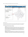
Guide for the Development of the Digitized Mapping Platform RFP/15/147 May 2015 TABLE OF CONTENT 1 2 3 4 5 Introduction ........................................................................................... Error! Bookmark not defined. 1.1 Purpose .......................................................................................... Error! Bookmark not defined. 1.2 Scope .............................................................................................. Error! Bookmark not defined. 1.3 Abriviations and acronyms............................................................. Error! Bookmark not defined. Requirements of the system .................................................................. Error! Bookmark not defined. 2.1 Current infrastructure .................................................................... Error! Bookmark not defined. 2.2 CEC Webpage ................................................................................. Error! Bookmark not defined. 2.3 Hosting .......................................................................................................................................... 4 Map and functional elements of the DMP............................................. Error! Bookmark not defined. 3.1 Elements of DMP .......................................................................................................................... 5 3.2 Sessions of information.................................................................. Error! Bookmark not defined. 3.2.1 Election information .............................................................. Error! Bookmark not defined. 3.2.2 Disability access ..................................................................... Error! Bookmark not defined. 3.2.3 Election results ....................................................................... Error! Bookmark not defined. 3.3 Time slider ...................................................................................... Error! Bookmark not defined. 3.4 Navigation ..................................................................................................................................... 6 3.5 Save and download function ......................................................... Error! Bookmark not defined. 3.6 Zoom function ................................................................................ Error! Bookmark not defined. 3.7 Search function .............................................................................. Error! Bookmark not defined. 3.8 Legend of the map ......................................................................... Error! Bookmark not defined. Non-functional and other requirements ............................................... Error! Bookmark not defined. 4.1 Languages....................................................................................... Error! Bookmark not defined. 4.2 Ownership costs ............................................................................. Error! Bookmark not defined. 4.3 Security .......................................................................................... Error! Bookmark not defined. 4.4 Architecture, interaction and integration ...................................... Error! Bookmark not defined. 4.5 Design............................................................................................................................................ 9 4.6 Consistence .................................................................................... Error! Bookmark not defined. 4.7 User training................................................................................... Error! Bookmark not defined. 4.8 User manual ................................................................................... Error! Bookmark not defined. 4.9 Codes and intellectual property..................................................... Error! Bookmark not defined. DMP interface ........................................................................................ Error! Bookmark not defined. 2 1 INTRODUCTION 1.1 PURPOSE This document continaing a functional and technical guide is part of the project for the devlopment of the Digitized Mapping Platform (DMP). The purpose of this document is to offer clear guidelines to potential vendors, one of which will be contracted for the development of the platform. This document contains a functional and technical guide, visuals of internal components of the software, and describes the relationship between different components. It is expected that this document is used as a foundation for the development of the DMP. 1.2 SCOPE This web-based platform will present the data in a visual and user friendly format, so that persons with little experience with such platforms, find it easy to use. The platform should have the ability to import data and manually add, amend and delete data and other necessary information. The platform will be developed independently, and then be integrated in the Central Election Commission (CEC) website. 1.3 ABBREVIATIONS AND ACRONYMS Abbreviation DMP IBM IFES CEC PC SQL TCO PS Description Digitized Mapping Platform The International Business Machines Corporation ( Computer/Server brand) International Foundation for Electoral Systems Central Election Commission Polling Center ( In Kosovo, schools serve as polling centers) Structured Query Language Total Cost of Ownership Polling Station ( In Kosovo, class rooms serve as polling stations) 3 2 REQUIREMENTS OF THE SYSTEM 2.1 CURRENT INFRASTRUCTURE The Central Election Commission has its own functional infrastructure, including here computers, software, and network, and is able to locate web services like the DMP there. The table below contains the specifications and relevant information about the server that will host the DMP. SERVER 1 – Information about the server Operational System Windows Server 2008 R2 Enterprise 64-bit (6.1, Build 7601) Service Pack 1 (7601.win7sp1_gdr.140303-2144) Server Model IBM System x3550 M4 Server Processor Intel(R) Xeon(R) CPU E5-2630 0 @ 2.30GHz (24 CPUs), ~2.3GHz RAM Memory 16.0 Gb Network Gigabyte The server currently does not host any other service. The operating system of the servers is Microsoft Windows Server 2008 R2, whereas RDBMS in Microsoft SQL server 2008 R2. The CEC has the license to use the abovementioned versions. This information should guide potential vendors in determining the technology to develop the DMP, but not limit them in specific technology or versions. 2.2 CEC WEBSITE The CEC website was developed in ASP.NET, and the data is in the platform Microsoft SQL Serer 2008 R2. 2.3 HOSTING After the development of the DMP, it will be hosted on the CEC Server. The CEC will do the necessary technical preparations for the online launch of the DMP, by ensuring space on the disc, internet network, web servers, and the necessary services for the public. 4 3 THE MAP AND THE FUNCTIONAL ELEMENTS OF THE DMP The development of the DMP and the selectiton of the platform is the direct responsibility of the vendor. There are different mapping platforms available, and it is important that the proposed platform does not have any limitations in terms of closure of the platform and/or limited access due to time or access based payment requirements. The vendor needs to ensure that the DMP is fully coordinated with the law on municipal border administration. CEC has the information on geographical coordinates (latitude and longitude) of polling centers and Municipal Election Commission (MEC) offices, and will provide that information to the vendor in Microsoft Excel format. Coordinates of other lcoations such as political party offices are currently being obtained. 3.1 ELEMENTS OF THE DMP In order to present the data in a visual format and enable DMP users to interact with the data, the DMP should contain at a minimum the following information to enable a user to find the information being sought: a) b) c) d) e) f) g) Information Section/Panel Time slider Navigation Save and Download Function Zoom Function Search Functions Legends 3.2 INFORMATION SEGMENTS The information segments show the division of the groups of data into sub groups, which will be presented in the interface of the DMP. The information segments of the DMP should be organized into three parts: 3.2.1 Election information In this segment, the general election information will be presented in these levels: a. Kosovo wide level b. Municipality level c. Polling Center level The information presented will contain the number of polling centers and their locations, the number of polling stations, the number of voters, the area from which voters will be drawn for that polling center, and the contact information of the Municipal Election Officers (MEOs). The second section will offer more information about electoral services at the municipal and central level to citizens, CSOs, and political entities. 5 3.2.2 Disability Access This segment will present information about the level of access for persons with disabilities in the following levels: a. Kosovo wide level b. Municipal level c. Polling Center level. 3.2.3 Election results This segment will present the information about election results at the following levels: a. b. c. d. Kosovo wide level Municipal level Polling Center level Polling Station level 3.3 TIME SLIDER There will be a time slider that will enable users to move through different time periods. By moving the time slider to a specific year or by clicking on the arrow that takes users through different time periods, the data wiill change to show users the information for different years. For example, by moving the time slider to 2014, the interface will filter the data and present the information about 2014. Where there is more than one election in a year a facility such as a drop down box will be required so that the user can select the election required. 3.4 NAVIGATION By clicking in a place or a zone on the map, a pop-up will appear that will contain the general election information about that particular place or zone. For example, if a user clicks on the municipality of Prishtina, then depending on which information section they chose, they will receive information related to the municipality of Prishtina. 3.5 SAVE AND DOWNLOAD FUNCTION The system should contain the function to save and export data, through which users can save and download maps as images or as data in Microsoft Excel format. 6 3.6 ZOOM FUNCTION Through the zoom function the user can change the position and size of the map. They can zoom in and zoom out by moving through the zoom slider. If the user has a rollerball mouse, they can use the rollerball to zoom in and out the map. Moving through the map: By clicking with a mouse in the map, users can move to any position on the map they want. 3.7 SEARCH FUNCTION The system should have a search function to enable users to search and find any information they need. 3.8 LEGEND OF THE MAP The DMP will have a legend with colors, which will present data series according to the geographic divisions or locations on the map. For example, in the section with information about disability access, the polling centers that do not have access will be marked with red, the ones that have partial access will be marked with orange, and the ones that have full access will be marked with green. The panel of colors should be editable, with the option of changing colors. 7 4 NON FUNCTIONAL AND OTHER REQUIREMENTS 4.1 LANGUAGES USED The DMP should be supported in three languages: 1) Albanian, 2) Serbian, and 3) English. 4.2 TOTAL OWNERSHIP COST The total cost of ownership (TCO) of this platform must be as little as possible. CEC and/or IFES shall not invest additional funding in new hardware and software. Also, the vendor needs to install and maintain the platform for the agreed period and train CEC staff and other users. After that CEC should takeover without the need to employ additional people to maintain the platform or the backend database. 4.3 SECURITY The role of the users will determine what priviledges they have from the system, depending on their level of engagement in the process. CEC and IFES have identified two categories of users. a) System administrator: IT Officers will serve as system administrators and will work directly under the authority of the Head of the IT Department in the CEC. Privileges for this user group include: Deleting/adding/changigng the data in the system, creating new categories and similar functions Reviewing the log history Similar IT competencies. b) Data entry personnel: Specific staff responsible for data entry. Their privileges include: Data entry for each section Updating and changing the data 4.4 ARCHITECTURE, INTERACTION, AND INTEGRATION The DMP is to be web-based and easy to use for all internet users through web-browesers. DMP is to be compatible with all common browsers (Google Chrome 4.0.201.1 and newer versions, Mozilla Firefox 3.0.6 and newer versions, Internet Explorer versions newer than 6 ) 8 DMP is to be able to support platforms like Windows , Linux , Macintosh as well as have responsive design in Android and iOS platforms. It is to support web server/application standards like: Microsoft IIS, Apache, Tomcat, Web Sphere, Web logic, Oracle HTTP server. DMP is to have the option of adding data in each segment in any time period, in subsequent years or processes. There are not to be limitations in terms of not being able to add, change, or delete data for each segment or subgroup of data. 4.5 DESIGN The information in the webpage is to be easy to read with reasonable contrast in colors to meet the needs of persons with visual disabilities. The colors of the DMP interface are to be in harmony with the colors of the CEC webpage. There is to be sufficient contrast between the text and the background. The size of the font in the regular text of the application is to be 12 pixel. 4.6 CONSISTENCY User interface (UI) and user experience (UX) are to be compatible throughout the application. The name of tags, graphics, tables, columns, as well as the presentation of search results, buttons, colors, and orientation are to be standardized. 4.7 TRAINING OF USERS There is to be a training of all users of the system, after the development of the DMP. The vendor is repsonsible to organize the training sessions with user groups. The system administrators will require advanced training in order to understand all functions of the sysems, and the options of making changes to the system. 4.8 USER MANUAL The user manual will be a necessary reference for users to understand how to use the system. The manual is to be integrated with the system in a way that is easy accessible for users, in a PDF format. 4.9 CODES AND INTELLECTUAL PROPERTY After the DMP is developed and its final version is installed, the codes and all intellectual property rights of the system will pass to the CEC. 9 5 DMP INTERFACE The DMP interface will be integrated in the CEC website. When opening the DMP there will be an initial interface with the Kosovo map and the functions/tools of the DMP. The wireframes presented below illustrate to potential vendors the functions and tools required from the DMP. It is important to emphasize that these functions are fundamental and necessary. However, their forms, organization, and position in the interface do not necesarily have to be the same as portrayed in the instructions and wireframes. There are also no limitations to additional functions that may add value to the DMP. DMP SECTIONS All segments of the DMP will have three sections: Section A: General Information Section B: Statistics Section C: Map Section A will be used for contact information in the Election Information module, disability assessment criteria in Disability Access module, and for presenting results in the Election Results module. Section B and Section C will present statistics and the map, respectively, throughout the three modules. The specific sections are illustrated in the wireframe below. SEGMENT I: GENERAL ELECTION INFORMATION Kosovo-wide Level The defaul view of the DMP will be the General Election Information segment, at the Kosovo wide level. The information presented in this level is as follows: Section A: Contact information for the CEC Section B: Statistics for 1) Number of municipalities, 2) Number of voters, 3) Number of polling centers, 4) Number of polling stations. Section C: The map of Kosovo, with borders for specific municipalities 10 Figure 1- The default view of the DMP, with the three sections specified. Municipality Level After the default view is presented, the user can click any municipality. Upon the click, an image of the municipality will be shown, with pins on specific polling centers and a special pin for the MEO office. The information presented in this level is as follows: Section A: Contact information for the MEO Section B: Statistics for the specific municipalities 1) Number of voters, 2) Number of polling centers, and 3) Number of polling stations. There will be a sub section here, where the list of the polling centers will be shown with the polling center number and school/building name. The user should be able to click on the school/building name, and the system will take the user to the pin in the map, where the school/building is located, where the box with information (see Section C) will be opened.* Section C: The map of the municipality with pins on polling centers. When clicking on the pin of a polling center, a box will be opened to show 1) the polling center number, 2) the name of the school/building, 3) number of voters in that polling center, 4) number of polling stations, and 5) 11 geographic area for voters who vote in this polling center. A function for uploading and attaching pictures to each location should be provided, so that the CEC can upload pictures at a latter time. * Upon clicking on the school/building name from the list in Section B or clicking directly on the pin, the system will zoom in to show the polling center cadastral area, which is the area from which voters are assigned to the polling center. SEGMENT II: DISABILITY ACCESS SEGMENT Kosovo-wide Level The default view for the Disability Access segment will be at the Kosovo-wide level. The information presented for each section are as presented below: Section A: This section will provide the percentages in specific locations and overall accessibility at Kosovo-wide level. Specifically, information will be provided for 1) Access to MEC Offices, 2) Access to Polling Centers, 3) Access to Political Entity Offices, 4) Access to Electoral Campaign Venues, and 5) Overall Accessibility. Section B: This section will provide information for the 11 disability access assessment criterion. The percentages shown will reflect the level of access per criterion in each of the location types throughout Kosovo. The assessment criteria include: 1. Number of accessible polling stations (polling centers only) 2. Number of non-accessible polling stations (polling centers only) 3. Accessible toilets/washrooms 4. Level access 5. A suitable ramp or lift 6. Obstacle free maneuverability for wheelchair users 7. No low hanging objects on wall 8. Non-slippery floors 9. Accessible tables 10. Accessible road to the entrance of the building 11. Accessible parking Section C: The Kosovo map will be shown with borders of municipalities. 12 Figure 2: The view of the Disability Access segment at Kosovo wide level. The information/criteria in Section A and B will have check boxes, which users can use to interact with the map. If they want information about a specific criterion in a specific location type, they will only check the check box, and the information will be presented visually in a map. For example, one user would like to know the percentage of accessible toilets in Kosovo. The user would click on the “Accessible Toilets” criteria in Section B, and check all types of locations in Section A, after which the muncipalities in the map of Kosovo would have different colors based on the percentage of accessible toilets they have in their polling centers and other election related locations. The percentage ranges would be shown in a legend on the side and can be different shades of one color or different colors. For instance, if only 7 % of toilets are accesible in one municipality, that would fall in the range of 0-10%, which would be marked with color A. Another municipality, where 15 % of the toilets are accesible would fall under the range of 11-20%, and as such that municipality would be marked with color B. Therefore, there would be different shades of the same color or different colors for different ranges of percentages. The specific percantages would also be written as drop down data for each respective municipalities. The users should also be able to generate more specific reports. For example, a user would like to know what municipalities have accessible parking in more than 50% of polling centers. The user should be able 13 to click on the “Accessible Polling Centers” in Section A, the criteria “Accessible Parking” and the ranges above 50% in the ledger with percentages. Through this comand, the system will highlight only the municipalities that have more than 50% accessible parking. Users should be able to do the same with more than one criterion. For instance, the user can look for municipalites that have have MEC offices with less than 30% “Obstacle free maneuverability for wheelchair users”, “A suitable ramp or lift” and “Non-slippery floors”. They would click on “Accessible MEC Office” in Section A, “Obstacle free maneuverability for wheelchair users”, “A suitable ramp or lift” and “Non-slippery floors” in Section B, and the ranges below 30 in the legend with percentages. Through this command, the system will highlight the municipalities that have less than 30% of the specified location that meet each of these three criteria jointly. Municipality Level From the Kosovo-wide level, users can click on a specific municipality, which will take them to a map of the municipality, with different type of pins for different election related locations. The information per section will include: Section A: This section will provide the percentages in specific locations and overall accessibility at the municipal level. Specifically, information will be provided for 1) Access to the MEO Offices (here with a yes/no, not percentages), 2) Access to Polling Centers, 3) Access to Political Entity Offices, 4) Access to Electoral Campaign Venues, and 5) Overall Accessibility per municipality. Section B: This section will provide information for the 11 disability access assessment criterion. The percentages shown will reflect the level of access per criteria in all location types in that municipality. The assessment criteria include: 1. 2. 3. 4. 5. 6. 7. 8. 9. 10. 11. Number of accessible polling stations Number of non-accessible polling stations Accessible toilets/washrooms Level access A suitable ramp or lift Obstacle free maneuverability for wheelchair users No low hanging objects on wall Non-slippery floors Accessible tables Accessible road to the entrance of the object Accessible parking Section C: The map of the municipality will be shown with different markers in different location types. The users will have to be able to derive user defined reports, just like in the Kosovo wide level, with different colors per location type, based on what color range the location type falls under. Polling Center/Other Location Type Level Upon clicking in the specific location type, the system will zoom in that mark. The information per section are as follow: 14 Section A: 1) Overall accessibility in location type and 2) Number of polling stations. Section B: This section will provide information for the 11 disability access assessment criterion, but in this case, not using percentages, but number for criteria 1 and 2 and Yes or No for the remaining criteria. The assessment criteria include: 1. 2. 3. 4. 5. 6. 7. 8. 9. 10. 11. Number of accessible polling stations Number of non-accessible polling stations Accessible toilets/washrooms Level access A suitable ramp or lift Obstacle free maneuverability for wheelchair users No low hanging objects on wall Non-slippery floors Accessible tables Accessible road to the entrance of the object Accessible parking Section C: The zoom in of the location type and the surrounding area. SEGMENT III: ELECTION RESULTS Upon clicking On the Election Results Segement, there will be two categories users can select from: 1) General Elections, and 2) Municipal Elections. Within the category of Municipal Elections, there will be four sub-categories: a) Municipal Assembly Elections, and b) Mayor Elections First round Second round. By election Next to these categories, there will be a time slider. The time slider will show the election years for each category. For General Elections, it will have the following years: 1) 2) 3) 4) 5) 2001 2004 2007 2010 2014 For Municipal Elections, it will have the following years: 1) 2000 15 2) 3) 4) 5) 6) 7) 8) 9) 10) 2002 2004 2007 2009 2011 2012 2013 2014 2015 Additional future years must be able to be added for each category of election General Elections: Kosovo wide level This will be the default view upon opening the General Elections segment, and will by default present the data for the latest General Elections. The information at the Kosovo wide level, per specific section will include. Section A: The results section will present the results of different political entities for specific elections. There will be two buttons that will enable the user to view the results in a 1) Chart Format as well as 2) Statistics Format. The Chart Format, which will serve as the defult format, will use charts to present the percentage of votes that political parties received. The Statistics Format, which will be presented after clicking the button, will have the following information per party: 1) Number of votes 2) Percentage of votes 3) Number of seats gained There will be a button assigned to each political entity, which when clicked will provide a pop- up screen with results for candidates for that party. The system should have the option to present the results in an ascending and descending order with a click. Section B: Statistics included at a Kosovo wide level on 1) Number of registered voters, 2) Number of voters who voted, 3) Overall turnout as a percentage. Section C: The map of Kosovo, divided with internal borders. General Elections: Municipality Level Upon clicking on the municipality, a map of the municipality will appear with marks/pin per polling center. The information per section will be as follows: Section A: The results of the political entities at the municipal level will be shown in the same format as in the Kosovo-wide level above. There will be a button assigned to each political entity, which when clicked will provide a pop- up screen with municipal results for candidates for that party. 16 Section B: Statistics at the muncipal level with be shown in the same format as per Section B in the Kosovo wide level. Section C: The map of the municipality with marks/pins per location type. General Elections: Polling Center Level Upon clicking on the polling center, there will be a zoom in to indicate the polling center and the sorrounding area. The information per section will be as follows: Section A: The results of the political entities at the polling center level will be shown in the same format as in the levels above. There will be a button assigned to each political entity, which when clicked will provide a pop- up screen with results for candidates for that party. Section B: Statistics at the polling center level with be shown in the same format as per Section B in the levels above. A drop down will provide access to text of results for each polling station within the polling center. Section C: The polling center with the surrounding area. The same format as for General Elections will be used for Municipal Elections. 17 Figure 3: The default view of the Election Results module. Statistical Information to be Available in Map, Graphics and/or Tabular Format Different forms of information are to be available by interacting with the map. For example: Individual party votes at national and municipal elections – national level : by clicking on political party name, a Kosovo wide presentation on the map and in tabular form of percentages of votes for this political party in each municipality for an election chosen through the slider Individual party votes at national and municipal elections – municipal level : by clicking on political party name, a Kosovo wide presentation on the map and in tabular form of percentages of votes for this political party in each polling station in chosen municipality for an election chosen through the slider Mayoral elections: municipalities won by each politcal party ( from first round election result or where held, second round election result) displayed with municipalities colored according to winning party. 18