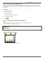
1
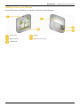
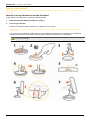
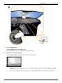
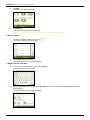
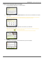
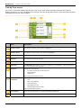
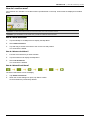
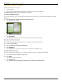
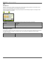
F15 User Manual en English Navman F15 | Important safety information Important safety information PLEASE READ CAREFULLY BEFORE INSTALLING PRODUCT IN VEHICLE This is the safety alert symbol. It is used to alert you to potential personal injury hazards. Obey all safety messages that follow this symbol to avoid possible injury or death. WARNING indicates a potentially hazardous situation which, if not avoided, could result in death or serious injury. CAUTION indicates a potentially hazardous situation which, if not avoided, may result in minor or moderate injury. CAUTION used without the safety alert symbol indicates a potentially hazardous situation which, if not avoided, may result in property damage. Removing original equipment, adding accessories or modifying your vehicle could affect the vehicle’s safety or make it illegal to operate in some jurisdictions. Follow all product instructions and all instructions in your vehicle owner’s manual regarding accessories or modifications. Consult your country’s and/or state’s laws regarding operation of a vehicle with any accessories or modifications. It is your sole responsibility to place, secure and use your Navman in a manner that will not cause accidents, personal injury or property damage. Always observe safe driving practices. Do not mount your Navman in a way that may interfere with the safe operation of the vehicle, the deployment of air bags or other safety equipment. Do not operate your Navman while driving. Before you use your Navman for the first time, familiarize yourself with your device and its operation. On main roads, the distance to an exit calculated by the Navman may be further than the distance shown on road signs. Road signs show the distance to the start of an exit while the Navman shows the distance to the next intersection, i.e., the end of the exit ramp or road. To prepare to exit a road, always follow distance information on road signs. Do not handle the Navman while it is hot. Let the product cool, out of direct sunlight. Do not expose the Navman to direct sunlight in an unattended vehicle for prolonged periods. Overheating may damage the unit. To discourage theft, do not leave your Navman, mounting bracket or any cables in plain view in an unattended vehicle. 2 Navman F15 | Important safety information Internal battery-specific safety information The Navman contains a non-replaceable internal lithium-ion polymer battery. The battery may burst or explode if mishandled, releasing hazardous chemicals. To reduce the risk of fire or burns, do not disassemble, crush or puncture the battery. Recycle or dispose of the battery safely and properly according to local laws and regulations. Do not dispose of the battery in fire or water. Only use the correct in-vehicle charger supplied by Navman to charge the Navman internal battery. Only use the Navman internal battery with the Navman unit. The Navman battery will stop charging when the ambient temperature is less than 0ºC (32ºF) or more than 45ºC (113ºF). Warning Notice to Drivers in California and Minnesota State law prohibits drivers in California and Minnesota from mounting objects on their windshields while driving. Other Navman mounting options are recommended and an alternative mounting option is included in this box. Navman does not take any responsibility for any fines, penalties, or damages that may be incurred as a result of disregarding this notice. See California Vehicle Code Section 26708(a); Minnesota Statutes 2005, Section 169.71. Failure to adhere to these warnings and cautions may lead to death, serious injury or property damage. Navman disclaims all liability for installation or use of the Navman that causes or contributes to death, injury or property damage or that violates any law. 3 Navman F15 | Important safety information Contents Important safety information...................................................................................................................2 Welcome................................................................................................................................................6 Getting to know your Navman ................................................................................................................7 How do I get started?.............................................................................................................................8 How do I turn my Navman on for the first time? ................................................................................8 How do I adjust the volume?...........................................................................................................10 How do I monitor the battery status?...............................................................................................11 What are the main screens I will use?..................................................................................................12 How do I navigate with GPS? ..............................................................................................................13 How do I go from A to B? .....................................................................................................................14 What if I miss a turn? ......................................................................................................................14 How do I search for an address? ....................................................................................................15 Case Study: How do I search for an address?............................................................................15 Using the Keyboard screen ........................................................................................................17 Using the Destination Search screen..........................................................................................17 How do I create a trip with multiple stops? ......................................................................................19 Case Study: How do I navigate to multiple addresses? ..............................................................19 How do I skip a waypoint during a multi-stop trip? ......................................................................23 How do I search for a Point of Interest (POI)?.................................................................................24 Case Study: How do I search for a Point of Interest?..................................................................24 How do I save Favorites and My Home?..............................................................................................27 How do I save a Favorite or My Home? ..........................................................................................27 How do I navigate to a Favorite?.....................................................................................................28 How do I navigate to My Home? .....................................................................................................28 How do I edit the name of a Favorite? ............................................................................................29 How do I delete a Favorite? ............................................................................................................30 How do I navigate to a recent location? ...............................................................................................31 How do I view my route?......................................................................................................................32 3D Map screen ...............................................................................................................................32 2D Map screen ...............................................................................................................................34 Route Overview screen...................................................................................................................36 Turn-by-Turn screen .......................................................................................................................38 How do I use the Map Menu? .........................................................................................................40 How do I avoid an area? .................................................................................................................41 How do I add an Avoid Area? .....................................................................................................41 How do I delete an Avoid Area? .................................................................................................41 How do I delete all Avoid Areas? ................................................................................................41 How do I preview a route? ...................................................................................................................42 How do I view my route statistics? .......................................................................................................43 How do I view statistics on my current route? .............................................................................43 How do I view statistics of my trips to date?................................................................................44 What can I customize?.........................................................................................................................45 Route Options.................................................................................................................................46 Route Calculation 1/4 .................................................................................................................46 Road Types 2/4 ..........................................................................................................................47 Driver Alerts 3/4..........................................................................................................................48 Data Recording 4/4.....................................................................................................................49 Map Display ....................................................................................................................................50 Map Display 1/3..........................................................................................................................50 Map Display 2/3..........................................................................................................................51 Select Map 3/3............................................................................................................................52 4 Navman F15 | Important safety information Map POIs........................................................................................................................................53 Volume ...........................................................................................................................................54 Screen Display................................................................................................................................55 GPS ................................................................................................................................................56 GPS Status 1/2...........................................................................................................................56 Set GPS Mode 2/2......................................................................................................................57 Language........................................................................................................................................58 Start-up...........................................................................................................................................59 Power .............................................................................................................................................60 Keyboard ........................................................................................................................................61 How does predictive text (abc, def…) work?...............................................................................61 Units ...............................................................................................................................................62 Units 1/2 .....................................................................................................................................62 Units 2/2 .....................................................................................................................................63 Tutorial............................................................................................................................................64 About ..............................................................................................................................................65 Saved Information...........................................................................................................................65 Reference ............................................................................................................................................66 Point of Interest categories .............................................................................................................66 For more information............................................................................................................................69 5 Navman F15 | Welcome Welcome Thank you for purchasing this Navman. This manual has been prepared to guide you through the operation of your Navman from first set-up through to continuous use. Please read this manual carefully before using your Navman for the first time. Keep this manual in a safe place and use as your first point of reference. Important information for using the manual It is important to understand the terms and typographical conventions used in this manual. Formatting The following formatting in the text identifies special information: Convention Type of Information Bold Navman components or items displayed on screen, including buttons, headings, field names and options. Italics Indicates the name of a screen. Icons The following icons are used throughout this manual: Icon Description Case study Warning Terms The following terms are used throughout this manual to describe user actions. Term Description Tap Press and release an item displayed on the touch screen. Tap and hold Tap and hold an item displayed on the touch screen for 2-3 seconds. Select Tap an item in a list or tap a command from a menu. 6 Navman F15 | Getting to know your Navman Getting to know your Navman We recommend that you familiarize yourself with your Navman’s basic operations. Power switch Speaker Battery indicator Socket for in-car charger Cradle socket 7 Navman F15 | How do I get started? How do I get started? Note: The first time you use your Navman, it may take several minutes to establish a GPS connection. For more information about GPS, see page 13. How do I turn my Navman on for the first time? To get started for the first time, complete the following steps: 1. Read the Important Safety Information on page 3. 2. Position your Navman Follow the instructions below to position your Navman in your vehicle: Note: Ensure that your Navman does not obstruct the driver's view, or interfere with the operation of the vehicle airbags and safety devices. If you are driving in California or Minnesota, you should NOT have the Navman mounted to your windshield. Instead you should use the enclosed mounting disc to attach the Navman to your dashboard. This is a permanent solution - the adhesive tape on the bottom of the mounting disc cannot be removed once fixed to your dashboard. WARNING 8 Navman F15 | How do I get started? 3. Turn your Navman on Slide the Power switch to the ON position. Your Navman will turn on and display the Language screen. 4. Select your preferred language From the Select Language screen, tap your preferred language. To prevent the Select Language screen from displaying on each start-up, clear the Show on start-up check box. You can change your preferred language while using your Navman (see "Language" on page 58). 9 Navman F15 | How do I get started? 5. 6. Read the warning message a) The Safety Agreement screen will display after you have selected your preferred language. Read the Safety Agreement message. b) To confirm that you have read and understood the message, tap Accept. The Tutorial will display. View the Tutorial When you have accepted the Safety Agreement, the first Tutorial screen will display. To prevent the Tutorial from displaying again on start-up, clear the Show on start-up check box. To move forward through the Tutorial screens, tap To view the previous screen, tap . To view the Tutorial again while using your Navman, see "Tutorial" on page 64. . When you have finished the Tutorial, the 3D Map screen will display. If you have a GPS fix, your current location will be displayed on the map. How do I adjust the volume? The volume on your Navman can be adjusted by the volume control on the Volume preference screen. To mute the volume from the map screens, tap To adjust the volume, tap and hold and then tap . to display the Volume preference screen. For more information on how to adjust the volume on your Navman, see “Volume” on page 54. 10 Navman F15 | How do I get started? How do I monitor the battery status? Your Navman has an internal battery that when fully charged, should provide power for up to 3 hours. The battery indicator light indicates the level of internal battery charge: Green - battery full Orange - battery charging You can monitor battery power status on the Power screen. To access the Power screen, tap and hold on the map screens. How do I charge the battery? The Battery Status bar displays External Power while the battery is charging; when the battery is fully charged, the Battery Status bar will display at 100%. To charge your Navman in a vehicle, plug the in-vehicle charger into on the bottom of your Navman and the other end into the vehicle power socket. 11 Navman F15 | What are the main screens I will use? What are the main screens I will use? Main Menu screen The Main Menu screen is your starting point for searching for a destination and allows you to customize preferences. The Main Menu can be accessed from the map screens by tapping of any screen. or by tapping the status bar at the bottom Map screens There are four map screens used to view the route to your destination: 3D Map 2D Map Route Overview Turn-by-Turn The Map screens can be accessed from the Main Menu screen by tapping You can cycle through the different map screens by pressing will display briefly as your cycle through). . on any map screen (the name of the map screen For more information on the map screens, see "How do I view my route?" on page 32. For information on using the Map menu from the 3D Map and 2D Map screens, see "How do I use the Map Menu?" on page 40. 12 Navman F15 | How do I navigate with GPS? How do I navigate with GPS? The Global Positioning System (GPS) is available at any time, free of charge, and is accurate to within 5m (15ft). GPS navigation is made possible by a network of satelites that orbit the Earth at around 20,200km (12,552mi). Each satelite transmits a range of signals which are utilized by GPS receivers, such as your Navman, to determine an exact location. Although a GPS receiver can detect signals from up to 12 satelites at any time, only four signals are required to provide a position or "GPS fix" (latitude and longitude), for vehicle navigation systems. How does my Navman receive GPS signals? Your Navman receives GPS signals via the internal GPS antenna. To guarantee the optimum GPS signal strength, ensure your Navman is outdoors, or in a vehicle outdoors, and has an unobstructed view of the sky. GPS reception is not usually affected by weather, however, very heavy rain or snow may have a negative effect on your reception. How do I view my GPS status? You can view your GPS status at any time from the map screens or the Viewfinder screen. displays green when a GPS fix is established and red when a GPS fix is unavailable. To indicate the reception strength of a GPS fix, displays between one and four green vertical bars. To view your GPS status in more detail, see "GPS Status" on page 56. To set your GPS mode, see “Setting your GPS mode” on page 57. For more information about GPS, refer to the GPS Navigation - Frequently Asked Questions guide at support.navman.com. 13 Navman F15 | How do I go from A to B? How do I go from A to B? Your Navman is equipped with maps that provide street-level detail for door-to-door navigation, including Points of Interest such as accommodation, parking areas, gas stations, railway stations and airports. When you ... Then ... know the address of your destination use the address-entry wizard to enter the address on page 15. want to make multiple stops use the Multi-stop Trip Planner screen to enter multiple waypoints on page 19. need to find a named site, feature, landmark or public venue search for a Point of Interest on page 24. WARNING For your safety, enter destination information before you start a journey. Do not enter a destination while driving. What if I miss a turn? Back-On-Track™ Automatic Rerouting You will be redirected if you make a wrong turn. A message informing you that your route is being re-calculated will display at the top of the screen. To cancel a route re-calculation tap . A warning will display, asking you to confirm the cancellation. If confirmed, both the re-calculation and your current route will be cancelled. 14 Navman F15 | How do I go from A to B? How do I search for an address? Enter a destination using the Destination Search, Keyboard and Preview screens, which used together form an address-entry wizard. This section provides a case study to help guide you through setting your destination. Quick Steps 1. Open the Destination Search screen 2. Select the country 3. Search for the city/area 4. Search for the street 5. Search for the house number 6. Tap . Case Study: How do I search for an address? This case study will show you how to enter an address and how to navigate to it. The address we will be using in this example is: 89 Navman Street Staten Island New York 10304 USA. Note: The above address is fictitious and used as an example only. Tip: Before you enter your destination address, ensure that you have set your route preferences. For more information, see “Route Options” on page 46. 1. Open the Destination Search screen The Destination Search screen will display. 15 Navman F15 | How do I go from A to B? 2. Select a state a) From the Destination Search screen, tap The Select a state screen will display. b) Select New York from the list. The Destination Search screen will display. . 3. Search for the City/Area a) From the Destination Search screen, tap City/Area. The Keyboard screen will display. b) Use the Keyboard screen to search for New York as the city or area of your destination, then tap the search result. The Destination Search screen will display. 4. Search for the street name and house number a) From the Destination Search screen, tap Street Address. The Keyboard screen will display. 16 Navman F15 | How do I go from A to B? Using the Keyboard screen The Keyboard screen will display when you are required to enter text, such as when searching for a street name. Search results will be listed in matching order, with the closest matches appearing at the top of the list. A maximum of 99 results will display. The Keyboard screen can display with various layouts depending on the information you need to enter, including alphabet, number, alternate characters and combinations of these. You can also choose the type of keyboard you prefer from alphabetic, QWERTY and keypad. For more information, see “Keyboard” on page 61. As you select each character, the first two results will display. Tap , then scroll to see more search results. To select a character or a search result, tap the character or search result. To delete a character, tap To display more characters, tap 123, alt or abc, if available. . Using the Destination Search screen The Destination Search screen is used to select your destination by area, street, ZIP code, Points of Interest, intersection, city, area or state. As you specify each part of the address, it will display at the top of the screen. The available options will change to reflect the parts of the address still to be completed. 17 Navman F15 | How do I go from A to B? b) Use the Keyboard screen to enter Navman Street as the street name of your destination, then tap the search result. Note: There may be multiple matches for a particular street name. Long streets that run through several neighboring areas, and common street names will produce search results ordered by their city or area name. c) Use the Keyboard screen to enter 89 as the house number of your destination, then tap the search result. The Preview screen will display. Note: If house numbers are available, but not the one that you require, you may have to choose the same street in a neighbouring area. Press and select another search result. If house numbers are not available for your selected section of the street the Preview screen will display. d) Complete one of the following: If you want to ... navigate to your selected destination Then ... tap . Your route is calculated; the 3D Map screen will display. view the position on the map screen tap the map to display the position on the 2D Map screen. view more information about your destination tap More. The Destination Details screen will display. add the destination to a multi-stop trip tap Add. The Multi-stop Trip Planner screen will display. The address is listed as a waypoint on the multi-stop trip. See “How do I create a trip with multiple stops?” on page 19. save the destination as My Home save the destination as a favorite tap Save. The New Favorite screen will display. tap Save as My Home. tap Save. The New Favorite screen will display. tap Save as Favorite. 18 Navman F15 | How do I go from A to B? How do I create a trip with multiple stops? You can use the Multi-stop Trip Planner screen to set multiple stops or waypoints for your trip. Your route will be calculated to go via each of these points in the specified order. You can save up to 198 multi-stop trips, each with up to 14 waypoints. Note: Waypoints added, updated or deleted after a multi-stop trip has commenced will not affect the current route. Quick Steps 1. Start your Multi-stop trip 2. Select the country 3. Search for the city/area 4. Search for the street and house number 5. Add additional waypoints 6. Tap . Case Study: How do I navigate to multiple addresses? This case study will show you how to set a multi-stop trip by entering multiple waypoints. The address we will be using in this example is: Note: The below address is fictitious and used as an example only. 124 Navman Street New York New York 10002 USA. Tip: Before you enter your destination address, ensure that you have set your route preferences. For more information, see “Route Options” on page 46. 1. Open your Multi-stop Trip screen The Multi-stop Trip Planner screen will display. 19 Navman F15 | How do I go from A to B? a) Tap Add. The Add to Trip Menu will display. b) Tap Address. The Destination Search screen will open. Note: You can also add waypoints using favorites, recent destinations and POI locations. 2. Select a state c) From the Destination Search screen, tap The Select a state screen will display. d) Select New York from the list. The Destination Search screen will display. . 3. Search for the City/Area a) From the Destination Search screen, tap City/Area. The Keyboard screen will display. b) Use the Keyboard screen to search for New York as the city or area of your destination, then tap the search result. The Destination Search screen will display. 20 Navman F15 | How do I go from A to B? 4. Search for the street name and house number a) From the Destination Search screen, tap Street Address. The Keyboard screen will display. b) Use the Keyboard screen to enter Navman Avenue as the street name of your destination, then tap the search result. Note: There may be multiple matches for a particular street name. Long streets that run through several neighbouring areas, and common street names will produce search results ordered by their city or area name. c) Use the Keyboard screen to enter 124 as the house number of your destination. The Preview screen will display. Note: If house numbers are available, but not the one that you require, you may have to choose the same street in a neighbouring area. Press and select another search result. If house numbers are not available for your selected section of the street the Preview screen will display. d) Tap Add. The waypoint is automatically saved and the Multi-stop-Trip screen will display. 21 Navman F15 | How do I go from A to B? e) Complete one or more of the following: If you want to ... Then ... add another waypoint Note: Waypoints added after a multi-stop trip has commenced will not be included in the current route. navigate to your selected destination tap . The Preview screen will display. tap . The 3D Map screen will display the calculated route. tap a destination point to move. The Preview screen will display. tap Up or Down. The Multi-stop Trip Planner screen will redisplay. change the order of your waypoints tap Add. The Add To Trip Menu will display. return to step 1a. delete all waypoints tap Clear. delete one waypoint save the multi-stop trip as a favorite tap a destination point to delete. The Preview screen will display. tap Delete. The Multi-stop Trip Planner screen will redisplay. tap Save. The New Favorite screen will display. tap Save as Favorite. The Favorite will be saved. 22 Navman F15 | How do I go from A to B? How do I skip a waypoint during a multi-stop trip? To skip a waypoint during a multi-stop trip, complete the following: 1. Tap the map. The Map Menu will display. 2. Tap Route, then Skip Waypoint. The next waypoint will be skipped and the route recalculated to the following waypoint. 23 Navman F15 | How do I go from A to B? How do I search for a Point of Interest (POI)? A POI is a named site, feature, landmark or public venue which can be displayed as an icon on the map. POIs are grouped by type, such as gas stations, parks, beaches and museums. Select a POI using the Destination Search, Keyboard and Preview screens, which used together form a POI-entry wizard. Tip: You can also quickly search for certain POIs based upon your current location via the Main Menu screen. This section provides a case study to help guide you through finding or setting your POI as a destination. Quick Steps 1. Open the Destination Search screen 2. Select a country 3. Search for the City/Area 4. Search for a POI 5. Tap . Case Study: How do I search for a Point of Interest? This case study will show you how to enter an address and navigate to it. The address used in this example is: Note: The below address is fictitious and used as an example only. Central Park New York New York 10024 USA Tip: Before you enter your destination address, ensure that you have set your route preferences. For more information, see “Route Options” on page 46. 1. Open the Destination Search screen The Destination Search screen will display. 24 Navman F15 | How do I go from A to B? 2. Select a state a) From the Destination Search screen, tap The Select a state screen will display. b) Select New York from the list. The Destination Search screen will display. . 3. Search for the city/area a) From the Destination Search screen, tap City/Area. The Keyboard screen will display. b) Use the Keyboard screen to search for New York as the city or area of your destination, then tap the search result. The Select POI Category screen will display. Tip: The list of categories is divided into Enabled Categories which are set to display an icon on the map screens, and Other POI Categories which will not display an icon. 4. Search for a POI a) Either tap Search by name to search in all POI categories, or select a category from the list. The Keyboard screen will display. 25 Navman F15 | How do I go from A to B? b) Use the Keyboard screen to search for Central Park as your destination, then tap the search result. The Preview screen will display. c) Complete one of the following: If you want to ... navigate to your selected destination Then ... . tap Your route is calculated and displayed on the 3D Map screen. view your position on the map screen tap the map to display the position on the 2D Map screen. view more information about your destination tap More. The Destination Details screen will display. add the destination to a multi-stop trip tap Add. The Multi-stop Trip Planner screen will display. The address is listed as a waypoint on the multi-stop trip. See “How do I create a trip with multiple stops?” on page 19. save the destination as My Home save the destination as a Favorite tap Save. The New Favorite screen will display. tap Save as My Home. tap Save. The New Favorite screen will display. tap Save as Favorite. 26 Navman F15 | How do I save Favorites and My Home? How do I save Favorites and My Home? You can save up to 200 destinations as favorites, one of which can be saved as My Home. You can save a favorite from the Preview screen after searching for an address, or from the Map Menu on the 3D or 2D Map screens. For more information, see "How do I use the Map Menu?" on page 40. How do I save a Favorite or My Home? 1. Search for an address until the Preview screen is displayed. 2. Tap Save. The New Favorite screen will display. 3. To change the name of the favorite, tap The Keyboard screen will display. 4. After you have entered a name for the favorite, tap The New Favorite screen will display. 5. Complete one of the following: . . If you want to ... Then ... save as a Favorite tap Save as Favorite. The favorite is saved. The Preview screen will display. save as My Home tap Save as My Home. The favorite is saved as My Home. The Preview screen will display. 27 Navman F15 | How do I save Favorites and My Home? How do I navigate to a Favorite? 1. Tap the Favorite destination you want to travel to. The Preview screen will display. 2. . Tap Your Navman will calculate the route from your current location. The 3D Map screen will display. How do I navigate to My Home? If you have not set an address as My Home, the first time you try to navigate to My Home you will be prompted to search for an address using the address-entry wizard. Option 1 - Via the Main Menu Your Navman will calculate the route from your current location. The 3D Map screen will display. Option 2 - Via the Favorite Destinations screen 1. From the Favorite Destinations screen, select My Home. The Preview screen will display. 2. . Tap Your Navman will calculate the route from your current location. The 3D Map screen will display. 28 Navman F15 | How do I save Favorites and My Home? How do I edit the name of a Favorite? 1. From the Favorite Destinations screen, select a favorite to edit. The Favorite Preview screen will display. 2. Tap Edit. The Edit Name screen will display. 3. To edit the name of the favorite, tap 4. After you have edited the favorite name, tap The Edit Name screen will display. 5. Complete one of the following: . . If you want to ... Then ... rename the Favorite tap Save. The favorite is saved. The Favorite Preview screen will display. save as My Home tap Save as My Home. The favorite is saved as My Home. The My Home Preview screen will display. 29 Navman F15 | How do I save Favorites and My Home? How do I delete a Favorite? 1. From the Favorite Destinations screen, select a favorite to delete. The Preview screen will display. 2. Tap Delete. The favorite is deleted. The Favorite Destinations screen will display. 30 Navman F15 | How do I navigate to a recent location? How do I navigate to a recent location? To make navigating to an address easier, your Navman will automatically save all your start locations and destinations in a list of recent locations. 1. Tap a recent location. The Preview screen will display. 2. Complete one of the following: If you want to ... calculate the route and open the 3D Map screen Then ... Tap . The 3D Map screen will display. view the full address details of the recent location tap More. The Recent Destination Details screen will display. save the recent location as My Home save the recent location as a favorite tap Save. The New Favorite screen will display. tap Save as My Home. tap Save. The New Favorite screen will display. tap Save as Favorite. 31 Navman F15 | How do I view my route? How do I view my route? When a route has been calculated, the 3D Map screen will display. You will be directed to your destination by spoken and visual instructions. The Map button cycles through the 3D Map, 2D Map, Route Overview and Turn-by-Turn™ screens. 3D Map screen The 3D Map screen displays your current position and follows your direction of travel. Tap and drag the screen, to move across the map. Tap the map to view the Map Menu (see "How do I use the Map Menu?" on page 40). Note: Depending on the country you are traveling in, the color of the direction and distance buttons may differ from the above example. Item Description Next instruction The direction and name of the street to turn in to. Direction and distance of next turn The direction and distance to your next turn. Route Your current route is highlighted. Current position Speed indicator Status bar Note: To repeat the spoken prompt of your next turn, tap the turn arrow. Your current position is marked with . Displays when you exceed your set speed limit. For more information, see “Driver Alerts 3/4” on page 48. Displays one of the following: The name of the street you are located on Speed warnings Active POIs. Tap to display the Main Menu screen. Main Menu Distance and Time Information The Main Menu button allows you to enter an address for your destination, customize preferences and receive updated traffic information. Tap to expand and see the following options: Time km/h or mph (Speed) TTG (Time to Go) DTG (Distance to Go) ETA (Estimated Time of Arrival). Tap to cycle through the options. Cancel route Cancels your current route. 32 Navman F15 | How do I view my route? Item Zoom Description . To view zoom options, tap To zoom out, tap To zoom in, tap . . Map The Map button allows you to cycle through different map screens. Mute/unmute volume, battery and GPS information. Tap to expand and see the following options: Mute/unmute volume Battery charge indicator GPS status indicator The icon displays green when a GPS fix is established and red when a GPS fix is unavailable. To indicate the reception strength of a GPS fix between one and four green vertical bars are displayed. 33 Navman F15 | How do I view my route? 2D Map screen The 2D Map screen shows your current position (if a GPS fix is active) and surrounding street names. If a route has been calculated, the route and turns are highlighted. Tap and drag the screen, to move across the map. Tap the map, to view the Map Menu (see "How do I use the Map Menu?" on page 44). Item Description Next instruction The direction and name of the street to turn in to. Direction and distance of next turn The direction and distance of your next turn. Current position Route Status bar Note: To repeat the spoken prompt of your next turn, tap the turn arrow. Your current position is marked with . Your current route is highlighted. Displays one of the following: The name of the street you are located on Speed warnings Active POIs. Tap to display the Main Menu screen. Main Menu The Main Menu button allows you to enter an address for your destination, customize preferences and receive updated traffic information. Distance and Time Information Tap to expand and see the following options: Time km/h or mph (Speed) TTG (Time to Go) DTG (Distance to Go) ETA (Estimated Time of Arrival). Tap to cycle through the options. Cancel route Zoom Map Cancels your current route. To view zoom options, tap To zoom out, tap To zoom in, tap . . . The Map button allows you to cycle through different map screens. 34 Navman F15 | How do I view my route? Item Description Mute/unmute volume, battery and GPS information. Tap to expand and see the following options: Mute/unmute volume Battery charge indicator GPS status indicator The icon displays green when a GPS fix is established and red when a GPS fix is unavailable. To indicate the reception strength of a GPS fix between one and four green vertical bars are displayed. 35 Navman F15 | How do I view my route? Route Overview screen The Route Overview screen gives you a bird’s eye view of your trip. Note: A route must first have been calculated for this screen to be available. Tap and drag the screen, to move across the map. Tap the map to view the Map Menu (see "How do I use the Map Menu?" on page 40). Item Next instruction Description The direction and name of the street to turn in to. Note: To repeat the spoken prompt of your next turn, tap the turn arrow. Direction and distance to next turn The direction and distance of your next turn. Note: To repeat the spoken prompt of your next turn, tap the turn arrow. Your final destination. Route Current position Main Menu Status bar Your current route is highlighted. Your current position is marked with ; if visible. The Main Menu button allows you to enter an address for your destination and customize preferences. Displays one of the following: The name of the street you are located on Speed warnings Active POIs. Tap to display the Main Menu screen. Distance and Time Information Tap to expand and see the following options: Time km/h or mph (Speed) TTG (Time to Go) DTG (Distance to Go) ETA (Estimated Time of Arrival). Tap to cycle through the options. Cancel route Zoom Cancels your current route. To view zoom options, tap To zoom out, tap To zoom in, tap . . . 36 Navman F15 | How do I view my route? Item Description Map The Map button allows you to cycle through different map screens. Mute/unmute volume, battery and GPS information. Tap to expand and see the following options: Mute/unmute volume Battery charge indicator GPS status indicator The icon displays green when a GPS fix is established and red when a GPS fix is unavailable. To indicate the reception strength of a GPS fix between one and four green vertical bars are displayed. 37 Navman F15 | How do I view my route? Turn-by-Turn screen The Turn-by-Turn screen displays the next four turns of your route, the turn direction, the street name and the distance to the turn. You can view all the turns in the list, using the up and down arrows. A route must first have been calculated for this screen to be available. Note: A route must first have been calculated for this screen to be available. Item Direction of turn Description The direction of the turn. Your next turn is highlighted. Note: To Repeat the spoken prompt of your next turn, tap the turn arrow. Distance to turn The distance to your next turn. Your next turn is highlighted. Instruction The direction and name of the street to turn in to. Your next turn is highlighted. Next turn Your next turn is at the top of the list. Upcoming turns The direction and distance of upcoming turns. Main Menu The Main Menu button allows you to enter an address for your destination, customize preferences and receive updated traffic information. Status bar Displays one of the following: The name of the street you are located on Speed warnings Active POIs. Tap to display the Main Menu screen. Distance and Time Information Tap to expand and see the following options: Time km/h or mph (Speed) TTG (Time to Go) DTG (Distance to Go) ETA (Estimated Time of Arrival). Tap to cycle through the options. Scroll buttons Allow you to view each turn by moving up and down through the list. Map The Map button allows you to cycle through different map screens. 38 Navman F15 | How do I view my route? Item Description Mute/unmute volume, battery and GPS information. Tap to expand and see the following options: Mute/unmute volume Battery charge indicator GPS status indicator The icon displays green when a GPS fix is established and red when a GPS fix is unavailable. To indicate the reception strength of a GPS fix between one and four green vertical bars are displayed. 39 Navman F15 | How do I view my route? How do I use the Map Menu? The Map Menu allows you to access navigational functions from the 3D Map and 2D Map screens. Displaying the Map Menu 1. Tap 2. Tap and drag to move around the map to your selected location. 3. Tap the map. The Map Menu will display. to display the 3D Map or 2D Map screen. Map Menu options The following options are available via the Map Menu: Menu Option Description Navigate To Calculates a route from your current location, if your Navman has a GPS fix. Show Details Displays the Preview screen from where you can: View details of the location Add the location to your multi-stop trip Save the location as a favorite Navigate to the location. Nearest POI Displays the Select POI Category screen. Select the Category, then Search for a POI to navigate to. For further information, see "How do I search for a Point of Interest?" on page 24. Avoid Area Allows you to add an Avoid Area by tapping and dragging the map. Un-Avoid Area Deletes the selected Avoid Area. Add to Trip Adds the location to your multi-stop trip. Route Displays the Route sub-menu from where you can: Set as Start. Sets the location as your departure point. Demonstrate. Starts the route demonstration, demonstrating navigation from your current position or departure point. Stop Demonstration. Stops the route demonstration. Skip Waypoint. Skips the next stop on your multi-stop trip. Show Summary. Displays a summary of your route, including your departure and destination addresses, total distance and total estimated time to your destination. Detour. Detours your route to avoid the next 1, 2, 5, 10 or 20 kilometers or the next 1, 2, 5, 10 or 20 miles. 40 Navman F15 | How do I view my route? How do I avoid an area? Your Navman can calculate a route that avoids a specified area on the map. Avoid Areas are displayed as shaded areas. CAUTION If no alternative route around an Avoid Area exists, the route calculation will fail. CAUTION If your destination is in an Avoid Area, you will be routed into that Avoid Area. How do I add an Avoid Area? 1. Tap the 3D Map or 2D Map screen to display the Map Menu. 2. Select Add Avoid Area. 3. Tap and drag to set the Avoid Area to the correct size and position. The Avoid Area is added. How do I delete an Avoid Area? 1. Find the Avoid Area that you want to delete. 2. Tap the Avoid Area to display the Map Menu. 3. Select Un-Avoid Area. The Avoid Area is deleted. How do I delete all Avoid Areas? The Saved Information screen will display. 1. Tap Delete Avoid Areas. 2. When the Caution dialog-box opens, tap Yes to confirm. All Avoid Areas are permanently deleted. 41 Navman F15 | How do I preview a route? How do I preview a route? Route demonstration allows you to: Preview a route. Plan and view a route without a GPS fix, such as when you are inside a building. The following steps will show you how to preview one route. 1. Select a departure point If you have a GPS fix, you do not need to select a departure point unless you want the demonstrated route to start elsewhere. a) Tap the 3D Map or 2D Map screen at your departure point. The Map Menu will display. b) Tap Route. The Route submenu will display. c) Tap Set As Start. The Map Menu will close, and the selected point is set as your departure point. 2. Select a destination point Set a destination either by using the address entry wizard or by using the Map Menu: a) Locate your destination. b) Tap your destination to display the Map Menu. c) Tap Navigate To. The Map Menu will close and the map screen will display the calculated route. 3. Demonstrate the route Once the route has been determined, you can demonstrate the route by completing the following: a) Tap the map screen to display the Map Menu. b) Tap Route. The Route submenu will display. c) Tap Demonstrate. The 3D Map screen will display the calculated route in Route Demonstration mode. 42 Navman F15 | How do I view my route statistics? How do I view my route statistics? Your Navman provides information on your: distance traveled average speed maximum speed time taken for trip stationary time. Trip information is presented in two different ways. These are: information for the current trip information for all trips to date, or since the tripmeter was last reset. How do I view statistics on my current route? The Tripmeter - Current Route screen is used to view statistical information for your current trip. a) Press and hold the Information button. The Tripmeter - Current Route screen will display. b) Complete one of the following: If you want to ... Then ... view statistics for your trips to date tap reset the tripmeter to display the Tripmeter - Global screen. tap Reset. tap Yes to reset. The Tripmeter - Current Route screen will display. 43 Navman F15 | How do I view my route statistics? How do I view statistics of my trips to date? The Tripmeter - Global screen is used to view statistical information for all of your trips to date, or since the trip meter was last reset. a) From the Tripmeter - Current Route screen, tap The Tripmeter - Global screen will display. b) Complete one of the following: If you want to ... Then ... view statistics for your current route tap reset the tripmeter . to display the Tripmeter - Current Route screen. tap Reset. A Warning dialog box will display. tap Yes to reset. The Tripmeter - Global screen will display. 44 Navman F15 | What can I customize? What can I customize? There are various customization options available to enhance your navigation experience. The Preferences menu screens are accessed by pressing To move forward through the Preferences screens, tap To revisit the previous screen, tap . 45 . Navman F15 | What can I customize? Route Options You can enhance your navigation experience by modifying aspects of your route and route calculation. Route Calculation 1/4 Complete the following: If you want to... Then... change the route type move the Route Type slider towards Fastest time to give high priority to the fastest time when calculating a route. move the Route Type slider towards Shortest distance to give high priority to the shortest distance when calculating a route. Note: Changing shortest distance over faster time can cause much longer journey time. change the preference for freeways move the Preference for Freeways slider towards Less often to use roads other than freeways where possible when calculating a route. Note: This option may not completely remove Freeways from a route. move the Preference for Freeways slider towards More often to use freeways where possible when calculating a route. Your preferences are automatically saved. 46 Navman F15 | What can I customize? Road Types 2/4 Complete the following: If you want to... Then... avoid toll roads select the Toll roads check box in the Avoid column. receive a warning if your route includes toll roads select the Toll roads check box in the Warn column. The warning will display at the start of every trip containing a toll road. avoid unsealed roads select the Unsealed roads check box in the Avoid column. receive a warning if your route includes unsealed roads select the Unsealed roads check box in the Warn column. The warning will display at the start of every trip containing unsealed roads. avoid ferry routes select the Ferry routes check box in the Avoid column. Note: Selecting Ferry routes does not allow you to travel between continents or even countries. receive a warning if your route includes ferry routes select the Ferry routes check box in the Warn column. The warning will display at the start of every trip containing ferry routes. Your preferences are automatically saved. 47 Navman F15 | What can I customize? Driver Alerts 3/4 Complete the following: If you want to... Then... enable a visual warning if the Main Menu screen is accessed in a moving vehicle select the Warn me not to operate my Navman while driving check box. enable a warning chime when traveling at or above a designated speed select the Alert me when my speed exceeds check box. select your preferred speed select your preferred speed from the Speed box. Your preferences are automatically saved. 48 Navman F15 | What can I customize? Data Recording 4/4 Complete the following: If you want to... Then... record a GPS log of your trips select the Enable GPS data logging check box. Your preferences are automatically saved. 49 Navman F15 | What can I customize? Map Display You can change the look and behaviour of the Map screens by customizing the Map Display preferences. Map Display 1/3 Complete the following: If you want to... Then... change the map colour scheme select your preferred scheme from the Map Scheme box. set the screen contrast to automatically adjust select the Auto day/night option. improve screen contrast in light or dark conditions select either the Day or the Night option to manually adjust the contrast. Your preferences are automatically saved. 50 Navman F15 | What can I customize? Map Display 2/3 Complete the following: If you want to... Then... enable automatic zooming during navigation select the Auto-zoom on main map screens check box. If selected, the 3D Map screen will automatically zoom in or out, depending on your speed, to allow optimal viewing of your route. display North at the top of the 2D Map screen select the Keep North at top of 2D Map screen check box. display “no entry” icons on “no entry” roads on the 2D Map and 3D Map screens select the Show no-entry road signs check box. Note: If not selected, the direction you are travelling in will display at the top of the 2D Map screen. Your preferences are automatically saved. 51 Navman F15 | What can I customize? Select Map 3/3 Complete the following: If you want to... Then... use maps from a different continent select a different continent from the maps you are currently using. When selected, the maps for the new continent will load and the 3D Map screen will display. Your preferences are automatically saved. 52 Navman F15 | What can I customize? Map POIs Points of Interest (POIs) are grouped into categories. You may choose to either display (or hide) icons of all POI categories on the map screens, or only display the icons from selected categories. For example, you may only be interested in entertainment venues and want to disable other categories such as schools. Complete the following: If you want to... Then... display all POI icons (ie, icons from all categories) Tap Turn All On. display no POI icons Tap Turn All Off. select a specific POI category icon for display on the map screens select the required POI category checkbox; repeat until all required categories are selected. Your preferences are automatically saved. 53 Navman F15 | What can I customize? Volume Complete the following: If you want to... Then... increase or decrease the volume move the Volume slider towards High to increase the volume. hear a tone when you tap the touch screen select the Audio check box. hear keyboard characters spoken to you select the Speak keyboard letters check box. move the Volume slider towards Low to decrease the volume. Your preferences are automatically saved. 54 Navman F15 | What can I customize? Screen Display Complete the following: If you want to... change the screen brightness Then... move the Screen Brightness slider towards Bright to increase screen brightness. move the Screen Brightness slider towards Dim to decrease screen brightness. Warning: Your Navman can heat up when the Brightness scale is set above 70% - i.e., when more than seven rectangles are colored - therefore, use lower brightness whenever acceptable. Your preferences are automatically saved. 55 Navman F15 | What can I customize? GPS GPS Status 1/2 Signals are transmitted by Global Positioning System (GPS) satelites orbiting the Earth. The GPS Status screen provides a visual representation of the information being received. Latitude and longitude are displayed, along with ground speed and the heading in degrees. The strength of each satelite is displayed on a bar chart. The satelites available from your current position are shown as gray, red and green colored bars: Bar color Description Gray No signal. Red A valid signal, but not being used to fix your position. Green A valid signal being used to fix your position. Resetting your GPS fix Occasionally, the GPS fix may need to be reset. This may occur if the receiver has been transported a long distance since last being used; for example, to a different country, and is still trying to establish the previous position. Complete the following: If you want to... Then... reset the GPS tap Reset GPS. 56 Navman F15 | What can I customize? Set GPS Mode 2/2 Complete the following: If you want to... Then... use GPS select the Normal option. use WAAS select the WAAS (only available in USA) option. use EGNOS select the EGNOS (only available in Europe) option. Note: WAAS - Wide Area Augmentation System is a navigation system developed for civil aviation by the Federal Aviation Administration (FAA), a division of the United States Department of Transportation (DOT). EGNOS - European Geostationary Navigation Overlay Service is a satelite based augmentation system (SBAS) under development by the European Space Agency, the European Commission and EUROCONTROL. Tip: You should only change the default setting if you are experiencing poor GPS performance. Your preferences are automatically saved. 57 Navman F15 | What can I customize? Language Complete the following: If you want to... Then... enable voice guidance select the Enable voice guidance check box. change the voice scheme select your preferred voice scheme from the Voice Guidance box. change the on-screen language select your preferred language from the Language box and tap Yes. Note: Only voice schemes that are compatible with the chosen language are displayed. Your language preference is saved and the map screen is displayed. Your preferences are automatically saved. 58 Navman F15 | What can I customize? Start-up Complete the following: If you want to... Then... show the Tutorial when you turn on your Navman select the Show the Tutorial checkbox. show the Language Selection screen when you turn on your Navman select the Show the Language Selection screen checkbox. Your preferences are automatically saved. 59 Navman F15 | What can I customize? Power The Battery Status bar shows the percentage of power left in the Navman battery; the words External Power will display when the battery is charging from an external power source. To charge the battery, see "How do I monitor the battery status?" on page 11. 60 Navman F15 | What can I customize? Keyboard Complete the following: If you want to... Then... use an alphabetic keyboard for entering information select the Use alphabetic type (a, b, c...) option. use a QWERTY keyboard for entering information select the Use QWERTY type option. use a keypad-type keyboard (predictive text) when searching for an address select the Use keypad type (abc, def...) for address searches check box. Your preferences are automatically saved. How does predictive text (abc, def…) work? Predictive text allows addresses to be searched by a single key-press for each letter, as opposed to the multiple keypresses. As you enter a letter of an address, your Navman will compare all possible combinations against the maps you have installed and determine which address you intended to type. For example: To enter New York, tap MNO DEF WXYZ WXYZ Your Navman will compare all possible combinations and display New York as a search result. You can add further letters to narrow the search. 61 Navman F15 | What can I customize? Units You can change the units used by your Navman by customizing the measurements preferences. Units 1/2 Complete the following: 1 If you want to... Then... change the time format select either the 12 hour or 24 hour option change the distance units1 select your preferred distance unit type from the Distance Units options. Your preferences are automatically saved. Only available when AU English, UK English or US English language is selected. 62 Navman F15 | What can I customize? Units 2/2 Complete the following: If you want to ... Then ... change the latitude, longitude position format select either the Decimal degrees or the Degrees, minutes and seconds option. Your preferences are automatically saved. 63 Navman F15 | What can I customize? Tutorial The Tutorial displays when you turn your Navman on, unless you have cleared the Show tutorial on start-up check box. You can view the Tutorial at any other time: To prevent the Tutorial from displaying again on startup, clear the Show on start-up check box to clear it. To move forward through the Tutorial screens, tap To revisit the previous screen, tap . . 64 Navman F15 | What can I customize? About This preference contains copyright and trademark information. Saved Information Complete the following: If you want to... Then... delete recent locations tap Delete Recent Locations. delete favorites tap Delete Favorite Destinations. delete avoid areas tap Delete Avoid Areas. restore factory default settings tap Restore Factory Defaults. Note: The Restore Factory Defaults option does not delete recent locations or saved favorite destinations. clear all settings; for example, for use in a rental car complete all of the above. When the warning dialog box displays, tap Yes. 65 Navman F15 | Reference Reference Point of Interest categories Icon Description Icon Description Airline Access Airport Amusement Park Arts or Cultural Centre Bank Beach Boat Ramp Breakdown Service, Car Repair Facility Building Camping Ground Car Dealer Caravan Park, Trailer Park Cash Dispenser Casino Centre of Settlement Church Cinema City Centre College or University Company Concert Hall, Music Centre, Opera Convention Centre, Exhibition Centre Courthouse Cultural Centre Dentist Doctor Drive-Through Bottle Shop Embassy Emergency Medical Service Ferry Terminal Fire Station Frontier Crossing General POI Golf course Government Office Hospital/Polyclinic Hotel or Motel Ice Skating Rink Important Tourist Attraction Leisure Centre, Sports Centre Library Military Cemetery Monument Mountain Pass Mountain Peak Museum Night life Open Parking Area Park and Recreation Area Gas station Pharmacy Place of Worship 66 Navman F15 | Reference Icon Description Icon Description Police Station Post Office Railway Station Rent-a car Parking Rest Area Restaurant Area Scenic or Panoramic View School Shop Shopping Centre Stadium Swimming Pool Tennis Court Theatre Tourist Information Office Travel Agency Vehicle Equipment Provider Veterinarian Water Sports Winery Yacht Basin Zoological park (zoo) Branded Points of Interest Branded Points of Interest are available on some maps. These include well-known restaurants, accommodation providers, tourist attractions, gas stations, etc. The icon will usually display the company logo. Point of Interest categories by Navman Icon Description Favorite destination Multiple route trip My home 67 Navman F15 | Reference Disclaimer Due to continued product development this information may change without notice. Navman does not warrant that this document is error-free. The screenshots and other presentations shown in this manual may differ from the actual screens and presentations generated by the actual product. All such differences are minor and the actual product will deliver the described functionality as presented in this User Manual in all material respects. Compliance WARNING This product, its packaging and its components contain chemicals known to the State of California to cause cancer, birth defects or reproductive harm. This Notice is being provided in accordance with California’s Proposition 65. Note: For regulatory identification purposes, Navman F15 is assigned a model number of N188 The manufacturer is not responsible for any radio or TV interference caused by unauthorized modifications to this equipment. Such modifications could void the user’s authority to operate the equipment. Marking labels located on the exterior of your Navman indicate the regulations that your model complies with. Please check the marking labels on your Navman and refer to the corresponding statements in this chapter. Some notices apply to specific models only. Federal Communications Commission (FCC) Statement You are cautioned that changes or modifications not expressly approved by the part responsible for compliance could void the user’s authority to operate the equipment. This equipment has been tested and found to comply with the limits for a Class B digital device, pursuant to part 15 of the FCC rules. These limits are designed to provide reasonable protection against harmful interference in a residential installation. This equipment generates, uses and can radiate radio frequency energy and, if not installed and used in accordance with the instructions, may cause harmful interference to radio communications. However, there is no guarantee that interference will not occur in a particular installation. If this equipment does cause harmful interference to radio or television reception, which can be determined by turning the equipment off and on, the user is encouraged to try to correct the interference by one or more of the following measures: Reorient or relocate the receiving antenna, Increase the separation between the equipment and receiver, Connect the equipment into an outlet on a circuit different from that to which the receiver is connected, Consult the dealer or an experienced radio/TV technician for help. This Class B digital apparatus complies with Canada ICES-003. Cet appareil numérique de la classe B est conforme à la norme NMB003 du Canada. Operation is subject to the following two conditions: (1) this device may not cause interference, and (2) this device must accept any interference, including interference that may cause undesired operation of the device. The software is based in part on the work of the Independent JPEG Group. The software application uses a modified version of the Minimal XML Library. The Minimal XML library and its use are covered by the GNU Lesser General Public License (www.gnu.org/licenses/lgpl.html). The modified source code is available from: www.navman.com/files/mxml.zip. Copyright © 2008 MiTAC International Corporation. Navman is either a registered trademark or trademark of MiTAC International Corporation and is used under license by Navman Technology Limited. All rights reserved. The software contains proprietary information of MiTAC International Corporation; it is provided under a license agreement containing restrictions on use and disclosure and is also protected by copyright law. Reverse engineering of the software is prohibited. No part of this publication may be reproduced, stored in a retrieval system, or transmitted in any form or by any means, electronic, mechanical, photocopying, recording or otherwise, without the prior written permission of Navman. Back-On-Track, Drive-Away, Smart and Turn-by-Turn are either registered trademarks or trademarks of MiTAC International Corporation and are used under license by Navman Technology Limited. All rights reserved. Location Identifiers © 2005 International Air Transport Association. POI Data © 2007 InfoUSA. All other trademarks and registrations are the property of their respective owners. Published in New Zealand. 68 Navman F15 | For more information For more information User Manual The User Manual can be downloaded from the Navman website: www.navman.com/manuals Online support For 24/7 help and support with Navman products, visit our Technical Support website at: support.navman.com Phone support If you have a faulty product or you would like to speak to a member of our Technical Support team, please call the following number: +1-(866)-9NAVMAN Monday to Friday 10:00 – 15:00 (CST) 69 DOC-40-A