1
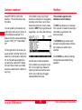
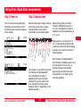
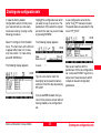
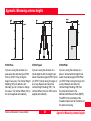
6 7 8 9 3 Step 6: Ending a survey, conts. Suggested exercise: Measure a very short baseline You can now switch off the sensor. Once power is off, put the equipment back into the shipping case. It might be a useful exercise to start with a very simple static baseline. You might now move to another site and repeat the procedure outlined in this chapter. Once your fieldwork is finished you can proceed by processing the collected data in SKIPro in order to get accurate baseline results. Choose a location which is free of obstructions. Mark two points on the ground which are a few meters apart and measure the distance by tape (for comparison later on) Transfer the data of both sensors into SKI-Pro and post-process the collected raw data. Compare the GPS results with your initial tape reading. The resulting slope distance should not differ by more than a few millimeters. Set up two System 500 sensors on tripod as explained in chapter 2. Log raw data simultaneously on each unit for about 10 minutes, using the PP_STAT configuration and newly created jobs. Measure and record the height of the antennas correctly using the height hook. Enter Point Id's of your choice Taking Static / Rapid-Static measurements 22 Static and Kinematic Surveys-2.0.0en