1
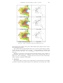
Fuzzy regional comparison of land use maps 97 template layers. The global matching results for the datasets analyzed outperform a number of commonly used overall similarity statistics. The work presented in this paper is a rst attempt at developing a fuzzy map comparison model that is a viable alternative to the Boolean map comparison procedures. Future research should be directed at several issues in order to expand the applicability of the model. First of all, the local matching process can be extended beyond the areal comparison of maps. The fuzzy inference system can be restructured to include membership functions for the matching of complex polygonal properties, such as shape and fractal dimension. These additional variables could aid in the explanation and description of the diŒerences between maps. For example, an increase in fractal dimension from one year to the next may be the result of an increase in the complexity of the land use pattern due to urban expansion. Secondly, the reliability of the fuzzy map similarity results and the performance of the fuzzy pattern matching model should be eld tested against a ground truthing dataset. Boolean comparison procedures generally assess the accuracy of change detection results with an error matrix and Kappa analysis. However, Foody (1995 ) states that a standard error matrix is inappropriate for computing the accuracy of a fuzzy change detection analysis because of its inability to accommodate the fuzziness in both the land use maps and the ground data. Ground data can rarely be assumed to be error free and often contain attribute and locational uncertainty. Therefore, a fuzzy accuracy assessment should handle the uncertainty in the agreement maps and ground data during the similarity analysis. For this project, the accuracy assessment will be a soft estimation of the closeness of the qualitative fuzzy labels assigned to the change maps and eld test sites. Note that fuzzy agreement labels will have to be qualitatively assigned to the test sites for the closeness measurement to be possible. Since the agreement maps and ground data will be fuzzy, the entropy of each data source can be calculated and used to determine an index of accuracy based on crossentropy (Zhang and Foody 1998 ). Cross-entropy will use the entropy values to measure the distance or closeness of the probability distribution of the agreement map to the probability distribution of the ground data. Formally, the closer the agreement map to the ground data, the lower the cross-entropy and the higher the map similarity accuracy. For a detailed discussion of cross-entropy see Foody (1995 ) and Chang et al. (1994 ). As a single index value, cross entropy can be readily interpreted to evaluate how well the fuzzy agreement and disagreement patterns represent change on the ground. Thirdly, research is required into the implementation of optimization techniques to obtain the best structure for the fuzzy inference system. It is possible that the local matching results are inaccurate because the shape of the membership curves and the amount of overlap between the functions are less than optimal. Preliminary research suggests that the solution may be to replace the fuzzy inference system with an Adaptive Neural Fuzzy Inference System (ANFIS). An ANFIS is functionally equivalent to a fuzzy inference system except that it uses a backpropagation neural network algorithm to ne tune the internal structure of the system. Using fuzzy agreement training data, the connective updating capabilities of the ANFIS would continually shape the membership functions of the matching system until a learning error threshold is reached (Jang et al. 1997 ). It is important to recognize that other fuzzy neural network systems, particularly fuzzy ARTMAP, are also applicable for the optimization process. The viability of fuzzy ARTMAP should be investigated because it avoids the problems of over tting and learning forgetfulness associated