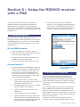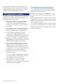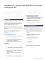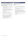
1
RD8000 SurveyCERT™
Real-time analysis software for
Pocket PCs and Desktop systems.
Operation Manual l Issue 2 l September 2008
90/SURVEYCERT-ENG/02
Preface
Before you begin
Trademarks
Please read this user manual before installing
SurveyCERT™ to your PC or PDA.
SurveyCERT is a trademark owned by Radiodetection
LTD, all rights reserved.
Read your Pocket PC user documentation thoroughly
before attempting to bond the RD8000 Receiver to your
Pocket PC or similar device.
Windows, Windows Vista, Windows Mobile, ActiveSync
and Microsoft Excel are registered trademarks of
Microsoft Corporation, all rights reserved.
Note that this manual and all its contents are subject to
change. Radiodetection products are under continuous
development.
ArcGIS is a trademark of ESRI, all rights reserved.
Radiodetection Limited reserves the right to modify the
product without notice and some product changes may
have taken place after this user manual was published.
Contact your local Radiodetection dealer or visit
www.radiodetection.com for the latest information about
the RD8000 product family, including this manual and the
bundled software
Important Notice
Radiodetection makes every effort to ensure that all
technical information, statements and recommendations
about RD8000 products are based on information
believed to be reliable, but the accuracy or completeness
thereof is not guaranteed. In no event shall Radiodetection
be liable for any loss, inconvenience, damage or problems
caused through use of any equipment or software.
Before using any RD8000 product (including
SurveyCERT™), the user should determine the suitability
of the product for its intended use. The user assumes all
risks and liability whatsoever in connection with such use.
Use of the SurveyCERT™ software is bound by
license agreement, a copy of which is included in the
SurveyCERT™ download bundle.
Copyright Statement
This manual is Copyright © 2008 Radiodetection LTD. All
rights reserved. Radiodetection LTD is a subsidiary of
SPX Corporation.
ii SurveyCERT™Operation Manual
MapInfo Professional is a trademark of MapInfo, all rights
reserved.
The Bluetooth word mark and logos are owned by
the Bluetooth SIG, Inc. and any use of such marks by
Radiodetection Ltd. is under license.
Open Office Calc is an open source project released
under the GNU Lesser General Public License.
Training
Radiodetection provides training services for most
Radiodetection products. Our qualified instructors will
train equipment operators or other personnel at your
preferred location or at Radiodetection headquarters.
For more information go to www.radiodetection.com or
contact your local Radiodetection representative.
Table of Contents
8.2 To Change the GPS port settings on the
SurveyCERT™ application
12
ii
Section 9. – ESRI ArcGIS
13
Copyright Statement
ii
9.1 Formatting the ENT file
13
Trademarks
ii
9.3 Importing data to ArcGIS
14
Section 1. – Introduction
1
Section 10. – Appendix
15
1.1 Overview
1
10.1 ENT file format
15
1.2 About this manual
1
10.2 PDA Resolution
15
1.3 Applications
1
10.3 Setting receiver model
15
Section 2. – Installation
2
2.1 System requirements
2
2.2 Installing on Windows
2
2.3 Installing on Pocket PC
2
Section 3. – Basic Operation
3
3.1 Main Menu (PC version)
3
3.2 The Toolbar
4
3.3 The Status Bar
4
3.4 Settings Menu
4
3.5 The Main Window
5
3.6 File Manager
5
Section 4. – SurveyCERT™ Charts
6
Preface
ii
Before you begin
ii
Important Notice
Section 5. – Using the RD8000 Receiver
with your PDA
7
5.1 Pairing the devices
7
5.2 Activate GPS (Optional)
7
5.3 Logging data
8
Section 6. – Using the RD8000 Receiver
with your PC
9
6.1 Pairing
9
6.2 Advanced Settings
Table of Figures
Figure 3.1: SurveyCERT™ PC Version
3
Figure 3.2: SurveyCERT™ PDA Version
3
Figure 3.3: PC Settings Window
4
Table 4.1 Locator Mode Charts
6
Figure 5.1: Windows Mobile 5 Bluetooth®
Manager
7
Figure 7.1: Reading locate data on the PDA
11
Figure 8.1 Windows Mobile GPS Setup
12
Figure 8.2 GPS and Bluetooth® Port settings
12
Table 10.1 ENT data format
16
9
6.3 Configure the SurveyCERT™ PC application
10
Section 7. – Reading data
11
7.1 Real-time viewing
11
7.2 Desktop viewing
11
7.3 Raw data view
11
Section 8. – Advanced GPS setup
12
8.1 To Check, Enable or Change your GPS port
settings
12
SurveyCERT™ Operation Manual iii
Section 1. – Introduction
Thank you for your interest in SurveyCERT™. The
RD8000 platform provides fast locate and effective
measurement of pipeline coating faults. Radiodetection
has engineered the RD8000 to communicate with
third-party devices such as PDAs using a Bluetooth®
connection.
frequency modes supported by the RD8000 receiver.
The free download bundle includes the following files:
Section 7 contains advanced GPS setup options.
• This manual in PDF format
• A readme file and EULA
Section 5 provides detailed instructions on bonding and
using your Pocket PC with the RD8000 Receiver.
Section 6 gives an overview of the methods available for
reading SurveyCERT™ logs on your PC or PDA.
Section 8 provides details on how to import the
SurveyCERT™ data log into ESRI ArcGIS and Section 9
contains Appendices for developers and advanced users.
• The SurveyCERT™ PDA application
• The SurveyCERT™ PC application
1.1 Overview
SurveyCERT™ is an application for Pocket PCs that can
read and chart logged data from the RD8000 receiver in
real-time. The application is also available as a desktop
viewer for Microsoft Windows® XP™ and Vista™. This
version is optimized for larger screens but includes all
the features of the PDA version, including the ability to
import logged data from the receiver via a Bluetooth®
connection.
1.3 Applications
The RD8000 is designed to be a flexible platform that is
interoperable with a broad range of industry applications.
One such application is the field of Geographic
Information Systems (GIS). Broadly, GIS is a discipline
dedicated to the analysis of spatial information that can
be drawn from a wide range of sources, including GPS
data, which is supported by SurveyCERT™.
Refer to Section 8 for an overview of using RD8000 locate
data with ESRI ArcGIS.
The PDA version is optimized for use on a VGA (or quarter
VGA) PDA running Windows Mobile®. To maximise
your experience using the software, Radiodetection
recommends using the software with a Bluetooth® and
GPS enabled PDA.
1.2 About this manual
This manual provides RD8000 users with instructions on
how to use your Bluetooth® and GPS enabled Pocket PC,
PDA or Smart Phone with the RD8000 Receiver.
Also included is a developer guide intended for GIS
professionals. The guide provides a brief tutorial on
how to convert the SurveyCERT™ data log to a format
compatible with ESRI ArcGIS.
Section 2 provides users with installation instructions for
desktop and Pocket PC systems.
Section 3 provides an overview of the PDA and PC
program’s basic function.
Section 4 lists the range of charts offered with the various
SurveyCERT™ Operation Manual Section 2. – Installation
SurveyCERT™ runs on either a desktop/laptop PC or a
Windows Mobile powered PDA or smart phone.
2.1 System requirements
Pocket PC
Windows Mobile 4.5 or later
Bluetooth® wireless module
GPS receiver (Optional)
PC
Microsoft Windows XP Professional with Service Pack 2*
Microsoft Windows Vista
USB Bluetooth® adapter (Optional)#
Microsoft .Net framework (or Visual C++ Redistribution
Package)
*NOTE Windows XP 64bit is not supported at this time.
#NOTE Some internal PC Bluetooth modules may not be
compatible. Radiodetection recommends using a USB
Bluetooth adapter.
2.2 Installing on Windows
NOTE: SurveyCERT™ is also installed with the
Radiodetection Enterprise Suite. You do not need to
download SurveyCERT™ if you already have this on
your system.
The PC application is distributed as a standalone
executable file. Simply copy the file to your directory of
choice and double click to run.
Note that to run the program you may also need to
install the Microsoft Visual C++ redistribution Package,
which is available as a free download from the Microsoft
website. This package is not required if you have the .Net
framework installed on your computer.
Note that at this time, Windows XP 64bit are
not supported.
SurveyCERT™ Operation Manual
2.3 Installing on Pocket PC
To install the application on your Pocket PC device,
you must use the Microsoft ActiveSync utility. This utility
is usually installed with your Pocket PCs application
suite otherwise you can download ActiveSync for free
from the Microsoft website. Consult the documentation
that accompanied your Pocket PC if you require more
information.
Windows Vista users please note that you must
synchronize your devise using Windows Mobile Device
Center.
Section 3. – Basic Operation
SurveyCERT™ is designed for rapid data capture and
analysis in the field. Most functions can be accessed
quickly using the toolbar. These functions are identical on
the PDA and PC versions of the software.
There are several layout differences to note. The PDA
version displays the file manager in a popup window and
the PC uses a split window that can be adjusted using
regular window handlers.
3.1 Main Menu (PC version)
Press the Menu button to display the following options:
• Settings – opens the Settings window.
• X-Axis – adjusts the Index and Distance values on
the x-axis.
• Autoscale – when On, forces the chart to automatically resize around the current data. Select Off to
turn Autoscale off.
The PC version also features a Menu bar situated below
the Title bar as with standard Windows applications. In
the PDA version, the button is located on the Toolbar.
• Exit – Exits the program.
2
1
1
3
4
2
3
Figure 3.1: SurveyCERT™ PC Version
Figure 3.2: SurveyCERT™ PDA
1. Main/Chart Window
2. Toolbar
3. Status Indicators
4. File Manager
SurveyCERT™ Operation Manual 3.2 The Toolbar
• Menu (PDA only) – opens the settings window.
• New – creates a new trace.
• Open – opens an existing trace saved in the ENT file
format.
• Save – saves the current trace as an ENT file on
your PDA.
• Logging Toggle – when selected, this option sends
data from the RD8000 receiver to your PDA.
• Locator Mode Toggle – changes the currently displayed locator mode.
• Chart Toggle – toggles the different charts available
to each Locator Mode (refer to Section 4).
• Grid Toggle – displays a latitudinal/longitudinal grid in
the main window.
• Range Toggle – displays the latitudinal/longitudinal
range in the main window.
3.4 Settings Menu
To access the Settings window on the PDA press the
Menu button with your stylus; on the PC version select
Menu -> Settings from the Main Menu bar. The Settings
window allows you to configure the following options:
• Grid – adjusts the number of longitude and latitude
grid lines.
• Colour – adjusts background and high/low value
colors.
• Ports – allows users to adjust the Bluetooth® and
GPS port settings of the application. These settings must match your PDA’s Bluetooth® and GPS
receiver ports; otherwise the application may be unable to communicate with the RD8000 receiver and
the GPS network.
• Test – displays raw connection data as plain text in
the main Window. Use this option to test or troubleshoot your Bluetooth® and GPS connections.
3.3 The Status Bar
The status bar on the bottom of the Main Window
provides connection and co-ordinate information. The
Status Bar includes the following indicators:
• Bluetooth® indicator – indicates that a Bluetooth®
connection is present. If this icon remains greyed
out, check your connection settings.
• GPS indicator – indicates that a GPS connection is
present. If this icon remains greyed out, check your
connection settings.
• Locator Mode indicator – indicates the RD8000
receiver’s current locator mode.
• Zoom indicator – indicates the current x-axis and
y-axis zoom settings.
• Position Indicator – displays the graph co-ordinates
when the stylus is pressed on the main window.
• Log Indicator – Indicates whether the PDA is logging
data from the RD8000 receiver. If either the GPS or
Bluetooth® link is lost during logging, the application
will continually attempt to re-establish the link.
SurveyCERT™ Operation Manual
Figure 3.3: PC Settings Window
3.5 The Main Window
3.6 File Manager
This window displays logged data in a range of charts.
The window also features navigation and zoom buttons
that allow you to pan or enlarge on a selected area. Press
the Main Window with your PDA stylus to activate the
context menu.
The File Manager displays the current active trace file
along with any other trace files you choose to open. When
you open the program, a temporary blank trace file is
created, ready to receive data from the RD8000 Receiver.
This file by default is the current active trace.
The context menu gives you the following options:
When a trace is active it can be edited with new trace
data logged from the RD8000 Receiver.
• Settings – shortcut to the applications Settings
Menu.
• X-Axis Distance – sets the X-Axis of the chart to the
distance of the first GPS co-ordinate.
• X-Axis Index - sets the X-Axis to be a contiguous
index for each data position in each locator mode.
This mode is essential if GPS is unavailable or if GPS
accuracy is insufficient.
• Zoom In – zooms in at the selected point.*
• Zoom Out – zooms out at the selected point.*
• Horizontal Shrink – zooms in along X axis.*
The File Manager allows you to load multiple locate files
and view them as an overlay on your current or active
trace. You can open additional files by pressing the Open
icon on the Toolbar and then selecting an existing ENT file
from an earlier trace.
Once multiple files are open, you can define whether a file
is visible on the main chart window, what color it is and
whether the file is active or not. To adjust these settings
on the PC version, Right Click the file name to display the
context menu. From there you can Activate the file, delete
it, display or hide it and change the color.
• Horizontal Stretch – zooms out along the X axis.*
• Vertical Shrink – zooms in along Y axis.*
• Vertical Stretch – zooms out along the Y axis.*
• Recentre – centers the current view relative to the
selected point.*
• Restore – returns the Main Window to its default
view.*
• Autoscale – when On, forces the chart to automatically resize around the current data. Select Off to
turn Autoscale off.*
*Function not available when autoscale is enabled.
SurveyCERT™ Operation Manual Section 4. – Survey charts
The primary function of the desktop and PDA version of
the software is to display locate data captured using the
RD8000 receiver. As such, both platforms are able to
display graphs corresponding to the frequency selection
modes on the RD8000 receiver.
The following table shows what information is displayed
by the various Locator Modes offered by the
RD8000 receiver.
Table 4.1 Locator Mode Charts
Available charts
Mode
Depth
Locate I
8KFF
dBMV
•
POWER
•
CPS
•
Phase
•
TSG
•
•
•
CDFF
•
•
ACTIVE
•
•
CD
•
•
SurveyCERT™ Operation Manual
•
•
•
•
•
The program allows users to import and chart survey data
collected using the RD8000 receiver using a compatible
PDA or PC. When used in the field with a Bluetooth® and
GPS compliant device, the program will chart locate data
in real-time using positional information. If using a PDA
without a GPS receiver, the PDA will only log the
receiver’s data.
Once logged, you can send this data to a PC and use it
with your company’s preferred GIS platform.
Section 5 – Using the RD8000 receiver
with a PDA
The portability of a PDA allows you to operate the
RD8000 receiver and gain real-time information for
extended periods in the field. If your PDA features a
GPS receiver, SurveyCERT™ will automatically add GPS
information. For information on the GPS data format, refer
to Appendix 9.1.
3. Once your PDA is paired with the RD8000
receiver, you can toggle the receiver’s Bluetooth®
mode to Auto. In Auto Mode, the receiver will
attempt to connect to the paired PDA when the
devices are within 10 meters of each other.
5.1 Pairing the devices
Bluetooth® devices must be paired before use. The
following procedure provides an example of how to pair
the RD8000 receiver to your PDA. For more information,
consult the RD8000 Operation Manual and your PDA’s
documentation.
On the RD8000 receiver
1. Press the Power Key to switch on the unit.
2. Press the Power Key once and then press the UP
Arrow Key once to display BLUT.
3. Press the Power Key once and then press the
DOWN Arrow Key to display PAIR.
4. Press the Power Key once to enter Pair mode.
On your Pocket PC
1. Pair your Pocket PC to the RD8000 receiver with
your Pocket PC’s Bluetooth® software. Note that
the procedure for pairing your PDA differs with
each model; consult the documentation that
came with your PDA for more information. The
following example should apply to most Pocket
PCs running Windows Mobile 5.
a.
From the Start menu on the PDA, select
Settings, then select the Connections Tab and
then select the Bluetooth® icon.
b.
Ensure the Bluetooth® Radio is on and make
the PDA visible to other devices
c.
Select the Devices tab and scan for new
partnerships.
d.
Create a partnership with the RD8000.
e.
Select the COM Ports tab and make a New
Outgoing Port with the RD8000 (RD8K_xxxx
where xxxx is the firmware version). Note the
port number of the selected COM port.
Figure 5.1: Windows Mobile 5
Bluetooth Manager
5.2 Activate GPS (Optional)
If your PDA features an integrated or external GPS
receiver you can log positional co-ordinates to your
locate data gathered with the RD8000 receiver. Note that
GPS functions differ in each PDA so check your PDA’s
documentation if you need help establishing a link to the
GPS network.
Once the GPS receiver is active, launch SurveyCERT™.
Note the Bluetooth® and GPS indicators beneath the
status bar. If either connection is established, the icons
will be bright blue. If there is no connection, the icons will
be grayed out. Note that it may take several moments to
find an active connection.
If the either connection is still inactive after several
moments, check to ensure your GPS receiver is active
SurveyCERT™ Operation Manual and your Bluetooth® radio is active and paired to the
RD8000 receiver. If problems continue, you may have
to alter the Bluetooth® and GPS port settings in the
application’s Settings Menu (See Section 3.4).
5.3 Logging data in realtime
Once Bluetooth® and the optional GPS connections are
established you can send data from the Receiver to your
PDA using the following procedure:
1. Create a New Trace by clicking on the New
Document icon on the SurveyCERT™ PDA
toolbar. This creates a new active trace and
ensures that any existing or older traces are not
overwritten.
2. On the RD8000 receiver, select the SEND option
from the settings menu. The Receiver will now
attempt to stream data to any paired device.
3. On your PDA, enable Bluetooth® logging
by pressing the Logging Toggle icon on the
SurveyCERT™ PDA toolbar. This allows the PDA
to receive data logs from the RD8000 Receiver.
4. Begin your survey with the RD8000 receiver and
a Radiodetection transmitter as described in the
RD8000 Operation Manual or User Guide.
5. When you find a reading you want to record,
press and hold the Antenna Select key on the
RD8000 receiver. The SurveyCERT™ bar graph
will spike and then return to its previous value.
The data will now be stored in your PDA’s memory
and displayed in your current active trace.
6. Continue your survey and log your findings as
described in Step 5.
7. Once the survey is completed, press the Disk icon
on the SurveyCERT™ PDA toolbar to save the
survey data as a ENT file on your PDA.
8. Once saved you can open the file using
SurveyCERT™ on your PDA or desktop
software or export it for analysis in your preferred
spreadsheet or GIS application.
SurveyCERT™ Operation Manual
Troubleshooting Log Connections
If you have correctly established the Bluetooth® and
optional GPS connections but cannot receive logged
data, please check the following:
Make sure the SurveyCERT™ PDA application is set
to receive data by press the Log mode button on the
toolbar.
Make sure the SurveyCERT™ PDA application is set to
the same locate mode as the receiver. If the modes are
different the PDA will still record the data however it will
not be displayed on-screen.
If you have trouble logging in realtime, you can conduct
your survey and send the data to your PDA or PC later.
Note that the graph doesn’t display data until a second
measurement is taken.
Section 6 – Using the RD8000 receiver
with your PC
You can send data from the RD8000 receiver straight to
your Bluetooth® compliant desktop or laptop PC. To do
this you must first pair the two devices. Once paired the
Bluetooth® link will allow you to send logged data to your
PC where you can read it using the SurveyCERT™ PC
application or import it into your preferred GIS platform.
6.1 Pairing
Bluetooth devices must be paired before use. The
following procedure provides an example of how to pair
the RD8000 Receiver to your PC. You can make the
connection using a USB Bluetooth® adapter providing it
supports the Bluetooth® Serial Port profile.
®
Note that the steps for pairing Bluetooth® devices may
differ depending on the brand of computer or the USB
adapter you have. As such, the following procedure is a
guide only.
5. A device named RD8K_xxxx should appear, if it
doesn’t make sure the RD8000 receiver is in Pair
Mode and click Search Again.
6. Select the RD8k_xxxx and click Next.
7. Tick ‘Use the passkey found in the
documentation’, enter 1234 for the passkey and
click Next to pair with the RD8000 receiver.
8. Completing the Add Bluetooth Device Wizard will
be displayed for a successful pairing.
9. Note the Incoming COM port assigned to the
device and click Finish.
6.2 Advanced Settings
Once paired, you must check to see if your PC’s
Bluetooth® port is configured to the same Baud rate and
parity settings. These settings can be adjusted as follows:
For more information, consult the RD8000 Operation
Manual and your PC or Bluetooth® module’s
documentation.
1. Right-click My Computer and select Properties.
On the RD8000 receiver
3. Expand the Ports(COM & LPT) menu tree
and double-click the device assigned to the
Bluetooth® Incoming port.
1. Press the Power Key to switch on the unit.
2. Press the Power Key once and then press the UP
Arrow Key once to display BLUT.
3. Press the Power Key once and then press the
DOWN Arrow Key to display PAIR.
4. Press the Power Key once to enter Pair mode.
On your PC
1. Connect a USB Bluetooth® adapter that supports
the Bluetooth Serial Port Profile into a USB port.
a.
Alternatively if your PC features an integrated
Bluetooth® module, switch it on following the
documentation that came with your computer.
2. Select the Hardware tab and then select Device
Manager.
4. Select the Port Settings tab and set:
a.
Bits per second to 115200,
b.
Data bits to 8,
c.
Parity to None,
d.
Stop bits to 1 and
e.
Flow control to Hardware.
5. Click OK to return to the Device Manager.
6. Close the Device Manager.
2. Select Start -> Control Panel and double click on
‘Bluetooth Devices’.
3. Click on Add to run the ‘Add Bluetooth Device
Wizard’.
4. Tick ‘My device is set up and ready to be found’
and click Next to search for Bluetooth® devices.
SurveyCERT™ Operation Manual 6.3 SurveyCERT™ PC configuration
Once the connection is established and you have
configured your Bluetooth® port settings, you must now
configure the SurveyCERT™ PC application to receive
data on the selected Bluetooth® port. To do so, please
use the following procedure.
1. If you haven’t already, open the SurveyCERT™
PC application by double-clicking its icon; this will
create a settings file,
2. Close the SurveyCERT™ PC application,
3. Locate the settings file, SurveyCERTIni.txt in the
directory where you installed the SurveyCERT™
PC application,
4. Open the settings file in Notepad,
6.4 Receiving Data
Once the connections are established, you can send the
logged data from the RD8000 receiver to the
PC application.
To do so:
1. On the SurveyCERT™ PC application, create a
new trace and press the Log button on the tool
bar.
2. On the RD8000 receiver select the SEND option
from the settings menu.
3. If the connection is successful, the PC
application’s Bluetooth® icon will become active
and the logged data will appear on-screen.
5. Find the line
PORT#BLUETOOTH#PORTNUMBER#,
4. Check to see if all data has transferred by toggling
through the receiver modes on the SurveyCERT™
PC Application.
6. Add the correct port number to the end of the
line,
5. Save the file by selecting Save As from the
File Menu.
7. Note if your PC is connected to a Bluetooth®
GPS receiver, you can also add the port
number the GPS device is using in the line
PORT#GPS#PORTNUMBER#
8. Save the file and exit; you may now reopen
SurveyCERT™ on you PC.
10 SurveyCERT™ Operation Manual
Section 7. – Reading data
You can read logged data in several ways. You can use
the SurveyCERT™ PDA application to read data in realtime or open previous trace files. For large screen viewing,
you can save the date to your laptop to desktop PC and
open it using the SurveyCERT™ PC version. Alternatively,
you can view and manipulate the raw data in a plain text
editor or CSV compatible spreadsheet application such
as Microsoft® Excel™ or Open Office Calc.
7.1 Real-time viewing
You can view the logged data as you record it in real time.
This process occurs automatically when a recorded log is
sent from the RD8000 receiver to the PDA. Each data log
will appear in the active trace window as a vector or point,
depending on the chart mode you have selected. You can
compare an active trace to historical traces saved on your
PDA, providing you with rapid analysis in the field. Refer
to Section 4 for a list of supported charts.
7.2 Desktop viewing
Away from the field, you have the option to view one or
more traces on a desktop or laptop computer using the
SurveyCERT™ PC viewer. The desktop viewer provides
you with the same analysis tools but utilizes the desktop’s
larger screen environment. Refer to Section 4 for a list of
supported charts.
Figure 7.1: Reading locate
data on the PDA
7.3 Raw data view
If required, you can view the raw data log in a plain text
editor or any spreadsheet application that supports CSV
plain text import. Microsoft Excel and Open Office Calc
are both capable of importing CSV data. This allows you
to format the data for use in GIS applications such as
ESRI ArcGIS or MapInfo Professional.
SurveyCERT™ Operation Manual 11
Section 8. – Advanced GPS setup
To use GPS with SurveyCERT™ on your PDA, you may
have to map your PDA’s GPS port to match those found
in the SurveyCERT™ setup menu. Alternatively, if your
PDA does not permit you to change its GPS port, you can
change the port settings found in the settings menu of
SurveyCERT™.
Note GPS settings will differ depending on your PDA’s
brand and as such this information is intended as a guide
only. Consult your PDA’s user documentation for more
information.
8.1 Configuring GPS port settings
1. From your PDA’s Start menu, select Settings, then
select the System Tab and then select the GPS
icon.
2. In the GPS settings page, go to the Programs
Tab.
a.
Figure 8.1 Windows Mobile
GPS Setup
Note the GPS COM port number and Baud
rate. An example is shown in Figure 7.1.
3. If applicable, ensure that this port is enabled.
4. Advanced users only. If necessary, change this
port number and baud rate to match the settings
in the SurveyCERT™ settings menu.
8.2 SurveyCERT™ GPS settings
1. Check the port number and baud rate of your
PDA’s GPS receiver.
2. Open SurveyCERT™ and press the Menu button
on the toolbar.
3. Select the Ports Tab. The PC settings page is
shown in Figure 7.2 as an example.
4. If necessary, change the GPS port number and
baud rate to match the GPS receiver’s settings.
5. Select the Test Tab and check the GPS box (and
Bluetooth® if required).
6. Press OK; if the connection is successful,
the main window will display raw GPS (and
Bluetooth®) data.
12 SurveyCERT™ Operation Manual
Figure 8.2 GPS and
Bluetooth® Port settings
Section 9. – ESRI ArcGIS
This section provides an example of how to format the
R8000 data log for export into ESRI ArcGIS.
The RD8000 receiver stores data as comma-separated
variables (CSV); the data is then saved as a plain text
file with a .ENT extension. The CSV format allows you to
import the tabular data to ArcView where you can then
convert the data to a shape file and manipulate the trace
as a map layer.
Note that there are several methods for using the RD8000
data in your GIS environment; the method outlined here is
intended as an example workflow only.
9.1 Formatting the ENT file
The ENT file is saved in CSV format with a .ENT
extension. Before importing the data into ArcView you
must add table headers to the data and give the file a
CSV extension. You can do this manually in any plain
text editor or in a spreadsheet application that supports
the CSV format. The example uses Microsoft Excel 2003
and 2007, however the process should be similar in older
versions of Excel and Open Office Calc.
Formatting in Excel
1. Copy the ENT file from your PDA or the RD8000
Receiver to your computer using Bluetooth® or
ActiveSync (Pocket PC only).
2. Open Microsoft Excel and create a new
spreadsheet.
3. In Excel 2003 and earlier, select Data -> Get
External Data -> Import Text File.
4. In Excel 2007, select the Data tab and click From
Text.
8. Press Next.
9. In Screen 2, select Comma as the delimiter and
deselect all other delimiters. You should now see
a preview of your formatted data.
10. Press Next.
11. Screen 3 allows you to change the cell type
of each column. In almost all applications, it is
sufficient to leave the default General cell type.
12. Press Finish.
13. Excel will now import your data beginning at the
row you selected. If you chose Row 2, you will
have an empty row in which to add the headers. If
you specified Row 1 then you will have to insert a
new row above your data.
Adding headers.
ArcView and other ESRI programs require that
headers are added to CSV files. The ENT file does not
include headers and so they must be added manually.
Alternatively, you could create a template with the headers
in place or you could automate the process using VBA.
Note that you can give the headers any name you wish,
however for ESRI programs they must be in CAPS and
contain no spaces.
Although the headers are not logged with the file,
SurveyCERT™ always logs the data in the same format
using pre-existing headers within the RD8000 receiver.
These headers are detailed in Appendix 9.1.
Once you have added headers you should then save the
data as a CSV file. You are now ready to import the data
to ArcView using the following procedure.
5. When the Import File dialogue box appears,
choose All Files from the Type of Files drop-down
box. Next, navigate to the ENT file, select it and
press Import.
6. Excel will then display a Text Import Wizard.
7. On the first screen, select the Delimitated radio
button. Next, choose which row you want the
data to begin at. Row 2 is recommended as you
will need to add the header columns. For file
origin, the default value is usually correct.
SurveyCERT™ Operation Manual 13
9.3 Importing data to ArcGIS
1. Open ArcMap. You can add the data to a new
map project or to an existing one. If you have
existing map data for your survey area, you can
overlay one or more RD8000 location datasets
into your project for analysis.
2. To import the data go to Tools -> Add XY data...
3. Select Choose File and select your formatted CSV
file using the file browser.
4. Once the file is selected you must then specify
your X and Y fields using the drop down menus.
The menus will list the headers you added in
Excel. Choose the headers most applicable
to your application (usually the Longitude and
Latitude data).
5. Next select the projection appropriate to
your survey.
6. Press Done, ArcMap will now import the data as a
layer in your project.
7. You can now save the layer as a shape file by
right-clicking the layer and selecting Data ->
Export Data. Choose a file name for the new
shape file and ensure the Import check box is
selected. Press Save.
Your map will now contain a new shape file layer that you
can manipulate according to your requirements. You can
now safely discard the CSV layer and save your project.
14 SurveyCERT™ Operation Manual
Section 10. – Appendix
10.1 ENT file format
This appendix provides developers with detailed
information on the SurveyCERT™ data format. The
RD8000 stores locate information as comma separated
variables using a plain text file with the extension, ENT.
These variables are formatted according to predefined
headers that carry data specific to the RD8000 receiver’s
trace information. The file also contains GPS header
information based on the NMEA specification. Note if a
GPS receiver is not used during the survey, the GPS value
data will default to NULL or 0 values.
10.3 Setting receiver model
The ini file should be set to reflect your receiver model.
1. Open the ini file in Notepad or any plain text editor
2. Find the line: UNIT#MODEL#<string>
3. Replace the string, if present, with your correct
model type i.e. either:
a.
RD8000PXL
b.
RD8000PDL
The headers are implied and are not included in the ENT
file. This allows developers to define custom headers that
best suits their host application.
Table 10.1 (overleaf) displays header information in the
Data column. The Values column lists the type of data
contained in each entry with an explanation where
applicable.
10.2 PDA Resolution
By default the PDA is set to display at VGA resolution
(640x480 pixels). If your PDA does not support this
screen size you have the option to change the size of the
application to quarter VGA. This option cannot be set in
the application itself; to do so you must edit the program’s
settings file using the following procedure.
1. First shut down the PDA application.
2. Locate the SurveyCERTIni.txt file on your PDA.
Note this file is created at first runtime and is
usually stored in the location of the exe file.
3. Open this file in any plain text editor.
4. Find the line: SCREEN#RESOLUTION#FULL
5. Change to SCREEN#RESOLUTION#QUARTER
and be sure to use all caps.
6. Save and close the file.
7. Re-launch the PDA program; the window size
should now fit you PDA screen.
SurveyCERT™ Operation Manual 15
Table 10.1 ENT data format
Col #
Data
Values
Comments
Specifies the locate mode
when reading was taken
RD8000 logging data
1
Locator mode
<String>
2
File Index
<Integer>
3
Locate Depth
<Float>
Depth in meters
4
Locate Current
<Float>
Current in mA
5
Phase
<Float>
Phase in degrees
6
Signal
<Float>
Signal level in dBmV
7
Signal strength
<Float>
8
Gain
<Float>
Optional GPS Data
9
GPS UTC
<Double>
GPS Universal Time Code
10
GPS Latitude
<Double>
Latitude in degrees
11
GPS Latitude Direction
0 – Unknown
1 – North
2 – South
3 – West
4 – East
12
GPS Longitude
<Double>
13
GPS Longitude Direction
0 – Unknown
1 – North
2 – South
3 – West
4 – East
14
GPS Fix Quality
0 – None
1 – GPS
2 – DGPS
3 – PPS
4 – Kinematic
5 – RTK
6 – Estimated
7 – Manual
8 – Simulation
15
GPS Number of Satellites
<Integer>
16
GPS Horizontal Dilution
<Double>
17
GPS Altitude
<Double>
18
GPS Altitude Units
0 – Invalid
Longitude in degrees
Specifies the type of precision
used
Altitude in meters
1 – Meters
19
GEO ID Height
<Double>
20
GEO ID Units
0 – Invalid
1 – Meters
21
DGPS Time since Update
<Integer>
22
DGPS Station ID
<Integer>
23
Time
0 – System
1 - GPS
Specifies if the time is set by
the GPS network or by the
GPS receiver’s internal clock
24
Day
Integer
Day of Month (1-31)
25
Month
Integer
Month of Year (1-12)
26
Year
Integer
4 Digit Year
16 SurveyCERT™ Operation Manual
Time in seconds
America
Europe
Asia-Pacific
Radiodetection
154 Portland Road
Bridgton, ME 04009, USA
Tel: +1 (207) 647 9495
Toll Free: +1 (877) 247 3797
Fax: +1 (207) 647 9496
Email: [email protected]
Radiodetection (UK)
Western Drive
Bristol BS14 0AF, UK
Tel: +44 (0) 117 976 7776
Fax: +44 (0) 117 976 7775
Email: [email protected]
Radiodetection (Asia-Pacific)
Room 708, CC Wu Building
302-308 Hennessy Road, Wan Chai
Hong Kong SAR, China
Tel: +852 2110 8160
Fax: +852 2110 9681
Email: [email protected]
Pearpoint
72055 Corporate Way
Thousand Palms CA 92276, USA
Tel: +1 800 688 8094
Tel: +1 760 343 7350
Fax: +1 760 343 7351
Email: [email protected]
Radiodetection (Canada)
Unit 34, 344 Edgeley Blvd.
Concord, Ontario, Canada L4K 4B7
Tel: +1 (905) 660 9995
Toll Free: +1 (800) 665 7953
Fax: +1 (905) 660 9579
Email: [email protected]
Radiodetection (France)
13 Grande Rue, 76220
Neuf Marché, France
Tel: +33 (0) 232 8993 60
Fax: +33 (0) 235 9095 58
Email: [email protected]
Radiodetection (Benelux)
Industriestraat 11, NL 7041
GD’s-Heerenberg, Netherlands
Tel: +31 (0) 314 66 47 00
Fax: +31 (0) 314 66 41 30
Email: [email protected]
Radiodetection (Germany)
Groendahlscher Weg 118
D-46446 Emmerich am Rhein, Germany
Tel: +49 (0) 28 51 92 37 20
Fax: +49 (0) 28 51 92 37 520
Email: [email protected]
To see the full range of products and
services provided by Radiodetection visit:
www.radiodetection.com
Radiodetection products are under continuous development and are subject to change, we reserve the right to alter
or amend any published specification without notice.
SurveyCERT is a Trademark of Radiodetection Ltd.
Copyright 2008 Radiodetection Limited. All rights reserved. Radiodetection Ltd. is a subsidiary of SPX Corporation.
90/SURVEYCERT-ENG/02
Radiodetection (China)
Hong Fu Group Office Building Room 322-326
Bei Qi Jia Township, Changping District
Beijing 102209, China
Tel: +86 (0) 10 8975 5540
Fax: +86 (0) 10 8975 5640
Email: [email protected]
Radiodetection (Australia)
Mactek Pty. Ltd
Unit 14, 5-7 Prosperity Parade
Warriewood NSW 2102, Australia
Tel: +61 (0) 2 9979 8555
Fax: +61 (0) 2 9979 7733
Email: [email protected]