1
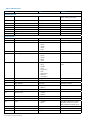
Table 10.1 ENT data format
Col #
Data
Values
Comments
Specifies the locate mode
when reading was taken
RD8000 logging data
1
Locator mode
<String>
2
File Index
<Integer>
3
Locate Depth
<Float>
Depth in meters
4
Locate Current
<Float>
Current in mA
5
Phase
<Float>
Phase in degrees
6
Signal
<Float>
Signal level in dBmV
7
Signal strength
<Float>
8
Gain
<Float>
Optional GPS Data
9
GPS UTC
<Double>
GPS Universal Time Code
10
GPS Latitude
<Double>
Latitude in degrees
11
GPS Latitude Direction
0 – Unknown
1 – North
2 – South
3 – West
4 – East
12
GPS Longitude
<Double>
13
GPS Longitude Direction
0 – Unknown
1 – North
2 – South
3 – West
4 – East
14
GPS Fix Quality
0 – None
1 – GPS
2 – DGPS
3 – PPS
4 – Kinematic
5 – RTK
6 – Estimated
7 – Manual
8 – Simulation
15
GPS Number of Satellites
<Integer>
16
GPS Horizontal Dilution
<Double>
17
GPS Altitude
<Double>
18
GPS Altitude Units
0 – Invalid
Longitude in degrees
Specifies the type of precision
used
Altitude in meters
1 – Meters
19
GEO ID Height
<Double>
20
GEO ID Units
0 – Invalid
1 – Meters
21
DGPS Time since Update
<Integer>
22
DGPS Station ID
<Integer>
23
Time
0 – System
1 - GPS
Specifies if the time is set by
the GPS network or by the
GPS receiver’s internal clock
24
Day
Integer
Day of Month (1-31)
25
Month
Integer
Month of Year (1-12)
26
Year
Integer
4 Digit Year
16 SurveyCERT™ Operation Manual
Time in seconds