1
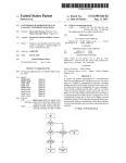
US008913552B2
(12) United States Patent
(10) Patent N0.:
(45) Date of Patent:
Agrawal et a].
(54)
SPATIOTEMPORAL ANNOTATION OF DATA
2006/0281437 A1 *
PACKETS IN WIRELESS NETWORKS
2007/0067626 A1
2007/0168524 A1
2007/0286195 A1 *
2008/0090589 A1 *
(75) Inventors: Dakshi Agrawal, Monsey, NY (U S);
Chatschik Bisdikian, Chappaqua, NY
2008/0125959
2008/0187137
2008/0305747
2009/0054074
(Us)
(73) Assignee:
International Business Machines
Corporation, Armonk, NY (US)
(*)
Notice:
Subject to any disclaimer, the term of this
patent is extended or adjusted under 35
Appl. No .:
Dec. 16, 2014
Cook ....................... .. 455/4042
3/2007 Louis Briancon et a1.
7/2007 Chao et al.
12/2007
4/2008
Ilnickl et al. ................ .. 370/392
Mikan et al. ............. .. 455/4561
5/2008 Doherty et a1.
Nikander et al.
Aaron
Aaron
8/2008
12/2008
2/2009
4/2009
10/2009
2/2010
Heater et al.
Frazier
GracieuX
(Continued)
U.S.C. 154(b) by 382 days.
(21)
A1
A1
A1
A1
2009/0104919 A1
2009/0248833 A1
2010/0048222 A1
12/2006
US 8,913,552 B2
OTHER PUBLICATIONS
Calcev, G. et al., “Method and algorithm for near real time cellular
13/012,387
network optimization using antenna tilt control,” IP.com N0.
(22)
Filed:
Jan. 24, 2011
(65)
(52)
(Continued)
Prior Publication Data
Us 2012/0188940 A1
(51)
1PCOM000132037D (Nov. 29, 2005).
Int. Cl.
H04 W 4/00
H04L 29/08
H04 W 4/18
US. Cl.
Jul. 26, 2012
Primary Examiner * Brandon Renner
Assistant Examiner * Faisal Choudhury
(74) Attorney, Agent, or Firm * Preston Young; Michael I.
(2009.01)
(2006.01)
(2009.01)
Chang, LLC
CPC ......... .. H04L 67/2819 (2013.01); H04W4/185
(2013.01)
(58)
USPC
................................ ..
Field of Classi?cation Search
CPC
......................... ..
USPC
370/328
H04W 8/12; H04W 64/00
Rice eltlal
reveals that spatiotemporal metadata is already present in the
References Cited
U.S. PATENT DOCUMENTS
2002/0023123
2005/0278375
2006/0069681
2006/0126645
4/2007
10/2008
aspect, a method for processing information streams pro
duced by end-computing devices that are transmitted over a
Wireless network having at least one network element is pro
541232011
370/328
See application ?le for complete search history.
7,203,752 B2
7,437,158 B2
tion information in Wireless networks are provided. In one
vided. The method includes the following steps. Data packets
which originate from the end-computing devices and are
received by the network element are inspected for spatiotem
poral metadata. Spatiotemporal metadata is inserted into the
data packets and the data packets are transmitted if the step of
inspecting the data packets reveals that the data packets are
missing spatiotemporal metadata. Otherwise the data packets
are transmitted if the step of inspecting the data packets
...................... .. ................................ ..
(56)
(57)
ABSTRACT
Techniques for annotating data packets with time and/or loca
A1
2/2002
A1* 12/2005 Mitchko et a1. .......... .. 707/1041
A1
3/2006 Lauper
A1* 6/2006 Devarapalli et a1. ........ .. 370/401
data Packets
18 Claims, 3 Drawing Sheets
m
I 302
PHASE 1
, 504
MW LOC'N‘RE
LANE—SETUP
SET LOCATlON
NEIWORK ELEMENT —-
PARAMETERS
(LANE)
l
we
INSPECT om PACKET FOR
m
—| LANE wms FOR DATA PACKETS I’— IUNE-OPERATION
SPATIOTEMPORAL uEnom
cousuu PERMISSION RULES
31o
coumu
PERMISSIBLE SPATIOTEMPORAL
METADATA'i
312
no
INSERT PERMISSIBLE
SPATIOTEMPORAL umom
31 ‘
PHASE 11
YES
US 8,913,552 B2
Page 2
(56)
References Cited
tional Conference on Convergence Information Technology, ICCIT
2007, Article No. 4420246, pp. 114-120, DOI 10.1109/ICCIT.2007.
U.S. PATENT DOCUMENTS
254. (Jan. 1, 2007).
2011/0026464 A1*
2/2011
Chen et al. .................. .. 370/328
2011/0078287 A1*
3/2011
Pacella et al.
2011/0080843 A1*
2011/0161427 A1*
4/2011
6/2011
Casey et a1. ................. .. 370/252
Fortin et a1. ................. .. 709/206
2011/0246866 A1* 10/2011 Abajian et al.
2011/0302308 A1* 12/2011 Prodan et al.
. 709/219
. 715/206
709/225
2012/0083289 A1*
4/2012
Li et al. ........ ..
. 455/4561
2012/0096110 A1*
4/2012
Sadovsky et al. ........... .. 709/213
OTHER PUBLICATIONS
Agosti, M. et al., “An Architecture for Sharing Metadata Among
Geographically Distributed Archives,” Springer-Verlag, First Inter
national DELOS Conference (Pisa, Italy), Digital Libraries: R&D,
LNCS 4877, pp. 56-65. ISSN: 0302-9743 eISSN: 1611-3349
ISBN19783540770879 (2007).
Kim, M. et al., “Web Services framework for geo-spatial services,”
Springer-Verlag. 4th International Workshop on Web and Wireless
Geographical Information Systems, W2GIS 2004 (Goyang Korea),
Lecture Notes in Computer Science (Lect. Notes Comput Sci.) (Ger
many) 2005 3428/-(1-13). ISSN: 0302-9743 (Sep. 19, 2005).
Choi, O.H. et al., “A Design of Location Information Management
System in Positioning Systems,” IEEE Computer Society, Interna
* cited by examiner
US. Patent
Dec. 16, 2014
2:
20:5.“
a=6::2
?g5 52 ca18-2w
cuwz w
2 :52?
I
Sheet 1 0f 3
US 8,913,552 B2
US. Patent
Dec. 16, 2014
Sheet 2 0f 3
US 8,913,552 B2
2N H
w
//:25: 826058
N.th
§g
mm358%
20:5th
?gmo zm 245
6“2.:”0 av2A05N.2:;me “23EN.s3w2t6h bv2Aom:<e E§E¢QME§S mEaz?m
=v:5.Q5ng2A<u._6“5_n0<
MEN
"HmIwaEg 55522:on
US. Patent
Dec. 16, 2014
Sheet 3 0f3
US 8,913,552 B2
FIG. 3
w
/
f 302
PHASEI <
I 304
INSTALL LOC-AWARE
NETWORK ELEMENT
LANE—SETUP
SET LOCATION
PARAMETERS
(LANE)
\
K
‘
[306
LANE WAITS FOR DATA PACKETS
LANE—OPERATION
1
INSPECT DATA PACKET FOR
/_ 308
SPATIOTEMPORAL METADATA
I
CONSULT PERMISSION RULES
’310
CONTAIN
PERMISSIBLE SPATIOTEMPORAL
METADATA?
312
PHASE 11 <
YES
INSERT PERMISSIBLE
, 314
SPATIOTEMPORAL METADATA
\
I
FIG. 4
400
[410
/
420w
PROCESSOR
425
NETWORK I/F
/
TO/FROM
A
~ COMPUTER
NETWORK
430w
MEMORY
MEDIA l/F
|-----J'-----|
4404
DISPLAY
:
l- _______ ___l
\435
‘
MEDIA
\450
US 8,913,552 B2
1
2
SPATIOTEMPORAL ANNOTATION OF DATA
PACKETS IN WIRELESS NETWORKS
cessing information streams produced by end-computing
FIELD OF THE INVENTION
the following steps. Data packets which originate from the
devices that are transmitted over a wireless network having at
least one network element is provided. The method includes
end-computing devices and are received by the network ele
ment are inspected for spatiotemporal metadata. Spatiotem
poral metadata is inserted into the data packets and the data
packets are transmitted if the step of inspecting the data
packets reveals that the data packets are missing spatiotem
poral metadata. Otherwise the data packets are transmitted if
the step of inspecting the data packets reveals that spatiotem
The present invention relates to location-aware wireless
networks and more particularly, to techniques for annotating
data packets with time and/or location information in such
wireless networks.
BACKGROUND OF THE INVENTION
Enhanced availability of mobile Internet has resulted in a
poral metadata is already present in the data packets.
A more complete understanding of the present invention,
hyper-growth of smart mobile applications. Many of these
as well as further features and advantages of the present
applications make use of spatially annotated information to
provide a broad set of location-aware services such as ?nding
the nearest (Greek) restaurant, or the nearest (cheap) gas
station, targeted mobile advertisements, and so on. The intro
invention, will be obtained by reference to the following
duction of smart, sensing-enabling technologies can only
hasten the growth trend of mobile applications.
detailed description and drawings.
BRIEF DESCRIPTION OF THE DRAWINGS
20
Many of these mobile applications can bene?t if their
present invention;
application (in the mobile device) or the application server (in
the cloud or datacenter) is aware of the spatial coordinates of
the information sources. If the source device is equipped with
a global positioning system (GPS), it can attach geo-coordi
nate metadata to application sessions. However, possessing
GPS may not always be possible (due to form factors (i.e.,
anything related to the form characteristics of an object such
as shape, size and weight), cost reasons, energy consumption,
etc.) or GPS may not be always operational, e.g., in indoor
environments.
FIG. 2 is a diagram illustrating several exemplary ways by
which a network element in a location-aware wireless net
25 work can attain location awareness according to an embodi
ment of the present invention;
FIG. 3 is a diagram illustrating an exemplary methodology
for processing information streams produced by end-comput
30
ing devices that are transmitted over a network having at least
one network element, such as the networks of FIGS. 1 and 2
according to an embodiment of the present invention; and
FIG. 4 is a diagram illustrating an exemplary apparatus for
Cellular network infrastructure can provide value-add by
estimating device location and creating location metadata for
processing information streams produced by end-computing
the device. Traditional cellular base-stations can estimate
device location using transmit power. Femto cells (e.g., in
FIG. 1 is a diagram illustrating an exemplary location
aware wireless network according to an embodiment of the
devices that are transmitted over a network having at least one
35
homes) or pico cells (e.g., in malls), and WiFi hotspots (e.g.,
network element, such as the networks of FIGS. 1 and 2
according to an embodiment of the present invention.
in airports) may be con?gured with location information.
DETAILED DESCRIPTION OF PREFERRED
EMBODIMENTS
This information can be stored in a network provider’ s infra
structure and become available through a location service to
end-user applications. The location service can query the
infrastructure of the provider to retrieve the location of the
40
As described above, in order to create open, smart, loca
source, or an estimate of it, that can then be used to customize
tion-enabled applications, the dependencies on existing loca
the location service response to the user, for example, where
tion infrastructures need to be reduced. Accordingly, pro
vided herein are techniques that allow location-based
services to exist independently of associating with a location
infrastructure that must be queried for location information.
The present techniques allow data streams to become spa
a user uses her mobile telephone to connect to a location
service provider, say, to search for movie theaters and movies
near her location. The location service provider queries the
cellular company provider for the location of the user. The
45
tiotemporally rich even when their sources are unable to
cellular company provides this information using, for
example, the cell tower information that the mobile telephone
was connected to, assisted GPS, etc.
As can be seen from this example, the location data and
hence location services are intimately tied to the cellular
provide the necessary metadata information. Further pro
50
vided herein are techniques to manage the content of meta
data added to satisfy end-user preferences, such as privacy
levels.
company provider who will also typically own the relation
According to the present techniques, the embedding is
ship with the end-user. In other words, data of spatiotemporal
performed by special network elements such as a WiFi base
signi?cance become tied to a location infrastructure and the
55
station, a gateway, a sensor network controller, etc. These
utility of these data is restricted by the access rights to that
network elements examine the traf?c that passes through
location infrastructure, e. g., requires access to location infor
mation from a cellular company provider.
them, for example using deep packet inspection (DPI), and if
Therefore, the creation of open, smart, location-enabled
applications, wherein the dependencies on existing location
the network elements ?nd location metadata missing, the
network elements insert on-the-?y the (estimated) location
60
information of the source in the data stream.
FIG. 1, for example, is a diagram illustrating exemplary
infrastructures are reduced would be desirable.
location-aware network 100. Network 100, in this case a
SUMMARY OF THE INVENTION
wireless network, includes at least one end-computing
device, i.e., user equipment (UE) 102, e.g., sensors, mobile
The present invention provides techniques for annotating
data packets with time and/or location information in wireless
networks. In one aspect of the invention, a method for pro
65
telephones, personal digital assistants (PDAs), personal com
puters, laptop computers, etc., accessing internet-based appli
cations 106 though a network element(s) 104, such as by a
US 8,9l3,552 B2
3
4
WiFi base station, a gateway, a sensor network controller
and/ or a femto cell access point (FAP) located at a home of a
user. An apparatus that may serve as a network element 104 is
impermissible location metadata (e.g., violating set privacy
policies), network element 104 can insert, remove and/or
otherwise alter on-the-?y the (estimated) location informa
provided in FIG. 4, described below. Information streams
produced by the end-computing devices are transmitted over
network 100. As will be described in detail below, according
to the present teachings the network elements examine the
information streams that pass therethrough, for example
tion of the source and/or time data in the data stream. The
concept of altering data packets on-the-?y is well known to
those of skill in the art. By way of example only, writing
on-the-?y is commonly done in routers which can even alter
information as a packet waits to be transmitted on an outgoing
using deep packet inspection (DPI), and if the network ele
mation (e.g., spatial, temporal and/or spatiotemporal meta
port. The router may, if necessary, momentarily delay the
transmission to perform this operation.
In FIG. 1, end-computing devices 102 (e.g., user equip
ment (UE)) produce sensed information that is then con
sumed by applications 106. As highlighted above, the user
data) of the source in the information stream. The concept of
equipment (UE) can include sensors. A sensor can be a
deep packet inspection by network elements with capabilities
simple, single task entities, a sensor in the strict sense, e.g., a
hazmat sensor sensing presence and/ or concentration of haz
ments ?nd location and/ or temporal metadata missing from
application data-carrying packets, the network elements
insert on-the-?y the (estimated) location and/or time infor
to read data packets (including payload) is well known to
those of skill in the art and thus is not described further herein.
The information stream may also be referred to herein as data
streams, with the understanding that the terms may be used
interchangeably. As noted earlier, the insertion (or replace
ment) of the spatiotemporal information in data packets is
done only to application data-carrying packets. Depending on
ardous material, a temperature sensor, a vibration sensor, an
acoustic sensor, etc. A mobile telephone is an example of a
multisensory device as it may include a microphone, an accel
20
the application context, there may not be a need to insert
spatiotemporal information to data packets such as system
management and control packets, set-up connection packets,
sors carried by a person (a pedometer, a heartbeat sensor, a
25
etc., not meant to be “seen” and processed by end-user appli
cations.
In the example shown in FIG. 1, there are two ?ows of data,
a ?rst ?ow and a second ?ow. The ?rst data ?ow (indicated by
dashed arrows) involves end-computing devices that do not
insert its location information as a proxy for the location of
30
embed location or time information in the data stream. These
such as sensors and/or mobile telephones (which may be
considered to be a type of sensor, see below). Network ele
40
data stream. Whether it is spatial metadata, temporal meta
data or spatiotemporal metadata, if any, that gets embedded in
the data stream depends on the design and application needs.
For example, there may be a sensor system that reports infor
45
50
room level, the apartment level, building level, street block
55
noti?cation and mapping it to a location. Thus, in this case
embedding spatial metadata would be preferable. In yet other
cases, a more powerful sensor may be equipped with a global
60
location along with the time of a sensed event (such as the
threshold crossing). In this instance, no additional spatial or
temporal metadata is needed.
By way of example only, network element 104 can be
con?gured to examine the data that passes through it, for
example using DPI, and if network element 104 ?nds location
metadata missing, incorrect existing location metadata and/or
information, the PAP could be con?gured by the user based
on various criteria, so as to satisfy privacy concerns of the
user. The FAP may be con?gured to embed home location
information at various degrees of granularity, such as at the
?cation (ID) from the packet with the threshold crossing
positioning system (GPS) device and thus can also add its
capabilities. For example, the process of embedding may be
in the data stream. For example, in the case of a FAP located
at the home of a user that is con?gured to embed location
location information. In this instance, embedding spatiotem
was noted. An application tied to the sensor measurements
would deduce the sensor location by reading a sensor identi
latter set-up would be bene?cial for situations where the
network element is moved, since it would not require any
input from the user to update its location. Exemplary embodi
ments involving such location-aware network elements
(LANEs) are described in detail below.
The location information may be coarse-grained or ?ne
grained depending on user preferences and the localization
policy-controlled (based, e.g., on a set of permission rules,
see below) to de?ne the location granularity to be embedded
may only provide the result of a temperature measurement
(e.g., 22 degrees Celsius (0 C.)), and include no time or
poral metadata would be preferable. In other occasions, a
sensor may report threshold crossings it experiences. For
example, the sensor may report that the temperature has just
gone past 50° C. and provides only the time when this event
address (or any other coarser/?ner location information, see
below). Alternatively, the PAP can have access to GPS capa
bilities and can determine its location automatically. The
rent clock time read by the network element) and/or spa
mation (e.g., temperature) only when the sensor system is
explicitly queried by the application. In this case, the sensor
the user equipment (UE) (with the assumption that the user is
close by). Accordingly, network element 104 is preferably
programmed with its location and/or has the capabilities to
determine its location. By way of example only, with a FAP in
a user’s home the user can program the PAP with a particular
35
and following consultation with privacy con?guration param
eters (see below), embeds, if necessary, spatial (e. g., location
information), temporal (e. g., a timestamp re?ecting the cur
tiotemporal metadata (e.g., spatiotemporal metadata) in the
body temperature sensor, etc.) and then pass this information
to a remote health-care monitoring application.
For the user equipment (UE) that does not embed location
information into the data stream, network element 104 can
end-computing devices can include user equipment (UE)
ment 104, e.g., a FAP, upon inspection of the ?rst data ?ow,
erometer, a GPS sensor and possibly a temperature sensor.
Hence, the mobile telephone itself is the sensor. Alternatively,
a Bluetooth®-equipped mobile telephone may collect infor
mation from multiple wearable Bluetooth®-equipped sen
level, neighborhood level or nothing at all. According to an
exemplary embodiment, when the location information is
coarse-grained the information includes only a home address
resolved to GPS coordinates, and when the location informa
tion is ?ne-grained the information has localization informa
tion, i.e., relative to the home address, such as room level.
A second data ?ow (indicated by a solid arrow in FIG. 1)
involves end-computing devices (e. g., user equipment (UE))
that can collaborate to estimate, e.g., using triangulation, their
local position, i.e., their location relative to each other. For
65
example, localization may be relative to a “local” coordinate
system. Upon transmitting their data, these end-computing
devices embed this relative location (localization informa
US 8,913,552 B2
5
6
tion) in the data stream they transmit (i.e., to network element
104). Network element 104, upon inspecting the data stream,
and following consultation with set privacy guidelines, may
re?ne the localization information. For example, network
“location awareness.” As described above, the present loca
tion-aware network includes user equipment (UE) (not
shown) accessing Intemet-based applications, in this case
element 104 may alter the relative location to a global loca
this case network element 204. As shown in FIG. 2, network
tion (e.g., while the original location may be noted simply as
“on the left side of the room,” the generic “room” may be
replaced with speci?c information such as “kitchen”) or
element 204 includes a downstream (incoming) port through
which data packets arrive and an upstream (outgoing) port
through which data packets are transmitted (see below).
FIG. 2 illustrates three non-limiting exemplary methods by
Internet applications 206, through a network element(s), in
replace altogether the location information as in the case
described above where the user equipment does not embed
location information into the data stream. User equipment
which network element 204 can acquire “location aware
ness.” A location-aware network element is also referred to
(UE) with location-awareness capabilities still only know a
herein as a “LANE.” The ?rst method involves manual con
relative location with respect to say a “generic” room. Net
work element 104 may know that these devices are within the
kitchen, so network element 104 can change the reference
coordinate system from that of the room to that of the house.
While network element 104 may insert, remove and/or
?guration of network element 204 by the user. Namely, a user
directly enters an address (e.g., “30 Main Street”) through a
LANE con?guration console (not shown) (e.g., through a
web interface or a client application interfacing to the con
?guration module of the LANE). In the example shown in
otherwise alter, supplement or replace the location informa
FIG. 2, the user accesses the LANE con?guration console
tion in the data stream as described above, other techniques
may also be used to change the location information. In one
through a web interface via the user’s personal computer (PC)
20
208. Optionally, network element 204 may consult with a
exemplary embodiment, whenever network element 104
geospatial service (having a geospatial database (GeoSp db)
identi?es missing (or non-complying, i.e., impermissible)
209) and substitute the address provided by the user with the
location information in a data packet ?ow, network element
GPS coordinates (latitude (lat) and longitude (long)) of the
104 can generate a brand new data packet to the same desti
location, or of an area containing the location (increase the
nation that includes the updated information (assuming that it
25
granularity). Google maps is such a geospatial service. With
also clears any non-compliant information). Alternatively, in
another exemplary embodiment, whenever network element
Google maps, for example, a user can provide an address and
retrieve the GPS coordinates of the address. For example, as
104 identi?es missing (or non-complying, i.e., impermis
shown in FIG. 2, the user has provided the address “30 Main
sible) location information, network element 104 replaces the
data packet with the missing (or non-complying, i.e., imper
Street” as its location and network element 204 consults a
30
missible) information with one that contains the allowable
alternatively supplement) the location information from the
location information and is otherwise identical to the original
packet. The implementation of both of these functions in a
DPI network element would be apparent to one of skill in the
art.
35
As highlighted above, the present techniques address sev
eral important aspects of spatiotemporal data transfer. The
?rst aspect is being able to allow location-based services to
exist independently of associating with a location infrastruc
ture that must be queried for location information. With ref
erence to the description of FIG. 1 presented above, the
40
present techniques provide for the embedding of spatiotem
poral metadata directly in the data (e. g., sensory data) stream.
This would satisfy the ?rst aspect as applications and services
can now extract the required spatiotemporal information
geospatial service to obtain the GPS coordinates for 30 Main
Street, which network element 204 can use to replace (or
user. This option may also be bene?cial in situations where,
for example, the user makes a mistake in inputting his/her
location and/or when the location information the user inputs
is not at the same granularity level as the set policy. By way of
example only, if the privacy policy in place is set at a coarser
granularity than what the user has inputted, the LANE can
substitute its GPS readings for that of the user’s but at the
correct privacy level. This would require that the network
element provide location information of its own, i.e., aside
from what the user provides.
The second method involves a bootstrap, or assisted con
45
directly from the data stream without requiring querying for
?guration, i.e., wherein a network provider remotely sets the
geospatial information for network element 204. Namely, a
network service provider (having a con?guration server 210)
location information from a third party, such as a cellular
of the network to which network element 204 is connected
company. The second aspect is allowing data streams to
remotely con?gures network element 204 when network ele
ment 204 powers on. According to an exemplary embodi
become spatiotemporally rich even when their sources are
unable to provide the necessary metadata information. Again
with reference to the description of FIG. 1 presented above,
50
the present techniques provide for embedding spatiotemporal
ment, an operator (from the network service provider) con
sults a geospatial database (install db) of the locations of its
installed LANEs (which may include actual subscribers’
home locations) and con?gures each LANE (remotely)
metadata to a data stream by an entity other than the source of
the stream. Serving as a surrogate of the source for the pur
accordingly.
data, spatiotemporal metadata becomes available to applica
The third method involves self-con?guration (e.g., GPS,
triangulation, etc.) by network element 204. In the third
tions and services even when the source is unable to supply
method, the LANE self-con?gures using GPS, triangulation
the required information. The third aspect is managing the
content of metadata added to satisfy end-user preferences,
such as privacy levels.Again with reference to the description
of FIG. 1 presented above, the present techniques provide for
60
information from other LANEs that already know their posi
tion, etc.
As highlighted above, the user equipment may be con?g
ured to obtain sensory information from (stationary placed)
sensors, e.g., placed in buildings, on roads, etc. As shown in
65
FIG. 2, sensory measurements obtained from these sensors
are part of the data stream to the network element. Privacy
guidelines may also be set at the sensor level.
Independently of how a LANE acquires its location infor
mation, end-users may set conditions of when and how to
pose of enriching the data stream with spatiotemporal meta
55
using con?gurable permission lists describing the allowable
information for embedding that are consulted prior to embed
ding any metadata to the data stream.
FIG. 2 is a diagram illustrating some exemplary ways by
which a network element in a location-aware network (such
as wireless network 100 of FIG. 1, described above) can attain
US 8,913,552 B2
7
8
embed location information in data streams, labeled “Privacy
with what frequency) spatiotemporal metadata may be
inserted into the data packets. For example, the permission
rules may dictate that spatiotemporal metadata may be
con?guration” in FIG. 2. In FIG. 2 this is shown as part of the
end-user manual con?guration of LANE, but alternatives are
possible. As indicated in FIG. 2, through some client appli
inserted into the data packet only once per source destination
?ow or only once per given interval of time, e.g., once every
cation running on, e. g., a personal computer, a user can manu
ally enter (type) the location information (e.g., “30 Main
10 minutes. This is done for ef?ciency sake, i.e., to prevent
Street”) to be recorded in a sensory data stream. Likewise,
taking duplicative actions.
privacy policies/con?guration may be entered manually by a
user through a client application. Such is the case, with social
With regard to the second phase, in step 306, the LANE
(e.g., network element 104) waits for data packets arriving at
network privacy rules when, for example, a social network
a downstream port, e.g., from the sensor side (see description
user speci?es who can see updates in personal status infor
of FIG. 2, above). Upon receipt of a data packet, in step 308,
the LANE inspects the packet for time and location informa
mation (friends, friends of friends, etc.). Spatial information
tion (spatiotemporal metadata). This inspection may involve
deep packet inspection (DPI) techniques, as the time and
may be treated in a very similar way, and describe under what
conditions (the clauses, see below) spatial information may
be revealed. By way of example only, a service subscriber
may provide her privacy constraints to the network provider
location information will likely be embedded in the payload
of the packet, e.g., within the payload portion of a transmis
sion control protocol/internet protocol (TCP/IP) packet.
who then con?gures LANE accordingly as part of a service
agreement the network provider has with the subscriber. In
FIG. 2, the privacy con?guration is shown as a collection of
However, the packet inspection may also include shallow
packet inspection, such as inspecting the TCP/IP packet head
<if . . . then> rules, where represent conditions, such as origin 20 ers, to extract information that could be used later.
Upon inspection of the packet, in step 310, the LANE
consults the list of permission rules for the spatiotemporal
of a data packet, destination of a data packet, application to
which a data packet relates, time and date, etc., and <then>
represent actions (shown in italics in FIG. 2) to be taken if the
conditions are satis?ed. Example actions shown in FIG. 2
include, adjusting the location granularity embedded in the
metadata in the packet and makes a determination as to
25
data stream, such as just a Zip code, or just a street name, or
embed nothing, or even remove any geospatial information
whether the packet contains permissible or impermissible
spatiotemporal metadata. As described above, the LANE
(e. g., network element 1 04) may be con?gured directly by the
user with the user’s privacy guidelines and/or the privacy
that might exist in the data stream. Using the example pro
guidelines may be set at other levels, e. g., at the sensor. Note
vided in FIG. 2, the user can designate that if the destination
that even if the data packet does contain spatiotemporal meta
data, the LANE may still consult the list of permission rules
of the data packet is XYZ, then only Zip code location infor
30
mation should be inserted into the data stream. On the other
to determine whether supplying spatiotemporal metadata is
hand, if the data packet destination is ABC, then all location
permissible (or impermissible).
information is removed. For example, a user may share his/
her full location information to a localization service for
packet contains permissible spatiotemporal metadata. If the
summoning a taxi cab, but only provide coarse location infor
mation that allows people to ?nd him/her (such as friends,
In step 312, the LANE determines whether or not the data
35
LANE transmits the packet out on an upstream port (see FIG.
2). The LANE then returns to waiting for a next packet from
downstream and steps 306-312 are repeated. On the other
where the user does not necessarily want them to know
exactly where he/ she is, but only that the user is in the area, or
in the same town). If the user con?gures these ‘customized’
privacy settings, the user can specify speci?c destinations/
40
settings, group s/types of destinations, etc. For example, a user
may specify location expression granules such as full address,
or just street name, or just Zip code, etc., and origin and
destination groups, and then (using the client application)
make statements of the form if data from group A are destined
packet contains permissible spatiotemporal metadata (i.e.,
the data packet meets all of the privacy guidelines), then the
hand, if the packet contains impermissible spatiotemporal
metadata (i.e., the data packet violates the privacy guide
lines), or if the packet contains insuf?cient or no spatiotem
poral metadata at all, then in step 314 the LANE inserts/
embeds allowable (permissible) spatiotemporal metadata in
45
the packet accordingly and transmits the packet out an
upstream port (see FIG. 2). Steps 306-312 are then repeated.
While packet inspection may be performed at each incom
ing packet, for example as in methodology 300, embedding of
to group B allow location granule C. This is how social
networks manage privacy rules for their content.
FIG. 3 is a diagram illustrating an exemplary methodology
300 for processing information streams produced by end
100 described, for example, in conjunction with the descrip
spatiotemporal metadata may occur only as often (or as fre
quent) as necessary. For example, the LANE may embed
permissible spatiotemporal metadata only once per source
destination ?ow (identi?ed by a common TCP/IP address/
tion of FIGS. 1 and 2, above. Methodology 300 includes two
phases, a ?rst phase (set-up of a LANE, steps 302 and 304)
port source and destination pair), or over a given interval of
time, e.g., once every 10 minutes. Or, as a result of DPI, the
computing devices that are transmitted over a network having
at least one network element, such as location-aware network
and a second phase (operation of the LANE, steps 306-314).
As describe above, LANE stands for location-aware network
element (i.e., a network element that has “acquired” location
awareness, see description of FIG. 2, above). With regard to
the ?rst phase, in step 302, the LANE is installed. A LANE,
such as network element 104 was described, for example, in
50
55
LANE may embed permissible spatiotemporal metadata once
per application session, or over a given interval of time, e. g.,
once every 10 minutes for packets that appear to be part of the
same application session. In this case, the step of “insert
permissible spatiotemporal metadata” is preceded by a deter
60
mination of whether embedding is necessary for reasons such
conjunction with the description of FIG. 1, above. In step 304,
the LANE (e.g., network element 104) is con?gured (“set
as the aforementioned ?ow or session rules.
location parameters”) such as acquiring location information
spatiotemporal metadata” can be interpreted quite generically
It is notable that in step 312, the term “contain permissible
based on what permissible is. Permissible will include both
for the LANE and con?guring the <if . . . then> privacy rules
(see, for example, the description of FIG. 2, above), referred
to more generally as permission rules below. As described in
detail below, the permission rules may also dictate when (i.e.,
65
the granularity of spatial information and also when the infor
mation can be permitted to be written. Hence, the example
above of writing a speci?c piece of information every 10
US 8,913,552 B2
9
10
minutes is an example of when a piece of spatial information
can be written. To be a little more speci?c, by way of example
a program con?gured to inspect data packets which originate
from the end-computing devices and are received by the
network element for spatiotemporal metadata; and insert spa
tiotemporal metadata into the data packets and transmit the
data packets if the step of inspecting the data packets reveals
that the data packets are missing spatiotemporal metadata,
otherwise transmit the data packets if the step of inspecting
the data packets reveals that spatiotemporal metadata is
already present in the data packets.
only, there might be various authors of permission conditions.
For example, end-users may specify content permissions
(what location information can be added), operators may also
provide operation permissions (when a location metadata can
be added in an information stream). A LANE device will
aggregate these permissions and when it performs step 312
the LANE device will decide what needs to be altered with
regard to spatial metadata. Thus, the permission rules, con
The machine-readable medium may be a recordable
medium (e.g., ?oppy disks, hard drive, optical disks such as
sulted in step 310 (above), may contain an aggregation of
permission rules from end-users and operators that determine
removable media 450, or memory cards) or may be a trans
the spatial information provided and the frequency by which
mission medium (e.g., a network comprising ?ber-optics, the
the information is provided in the sensory streams.
The above exemplary embodiments have considered the
world-wide web, cables, or a wireless channel using time
division multiple access, code-division multiple access, or
embedding or updating of permissible spatial information in
other radio-frequency channel). Any medium known or
information streams passing through a network element such
as network elements 104 or 204 employing techniques such
as DPT. In an entirely analogous manner, permissible tempo
developed that can store information suitable for use with a
ral information can also be embedded or updated in informa
tion streams. A network element, such as network elements
104 or 204, can employ a technique such as DPI to inspect a
20
430 could be distributed or local and the processor device 420
could be distributed or singular. The memory 430 could be
implemented as an electrical, magnetic or optical memory, or
any combination of these or other types of storage devices.
passing packet for temporal information. If temporal infor
mation is missing, a timestamp may be entered based on the
time indicated by the internal clock of the network element. A
user may con?gure the formatting details of the time, for
example, to provide both time and date information, or only
time, or con?gure the time granularity to be in minutes, sec
onds, milliseconds, etc. Note, that contrary to spatial infor
mation, time information can be, in general, more reliably
25
network, accessible through network interface 425, is still
30
within memory 430 because the processor device 420 can
35
retrieve the information from the network. It should be noted
that each distributed processor that makes up processor
device 420 generally contains its own addressable memory
space. It should also be noted that some or all of computer
system 410 can be incorporated into an application-speci?c
be less crucial than in the case of spatial information. None
theless, the same techniques employed for providing permis
or general-use integrated circuit.
Optional video display 440 is any type of video display
also be used to provide permission rules for temporal infor
mation used to con?gure rules for when to write and how to
suitable for interacting with a human user of apparatus 400.
Generally, video display 440 is a computer monitor or other
write (i.e., format) time information.
Turning now to FIG. 4, a block diagram is shown of an
apparatus 400 for implementing one or more of the method
40
ologies presented herein. By way of example only, apparatus
that various other changes and modi?cations may be made by
45
mitted over a wireless network having at least one network
element such as location-aware network 100 described, in
conjunction with the description of FIGS. 1 and 2. As high
by an application on end-computing devices that are trans
50
network 100.
end-computing devices and are received by the network
element for spatiotemporal metadata in the data packets
Apparatus 400 comprises a computer system 410 and
removable media 450. Computer system 410 comprises a
55
410 to interact with media, such as a hard drive or removable
60
herein may be distributed as an article of manufacture that
itself comprises a machine-readable medium containing one
or more programs which when executed implement embodi
ments of the present invention. For instance, when apparatus
400 is con?gured to implement one or more of the steps of
methodology 300 the machine-readable medium may contain
themselves;
consulting user-con?gurable permission rules that dictate
network, while media interface 435 allows computer system
media 450.
As is known in the art, the methods and apparatus discussed
mitted over a wireless network having at least one network
element, the method comprising the steps of:
inspecting, on the ?y, data packets which originate from the
con?gured to serve as one or more of the network elements in
processor device 420, a network interface 425, a memory 43 0,
a media interface 435 and an optional display 440. Network
interface 425 allows computer system 410 to connect to a
one skilled in the art without departing from the scope of the
invention.
What is claimed is:
1. A method for processing information streams produced
lighted above, network 100 includes at least one network
element (e.g., network element 104). Apparatus 400 can be
similar video display.
Although illustrative embodiments of the present invention
have been described herein, it is to be understood that the
invention is not limited to those precise embodiments, and
400 can be con?gured to implement one or more of the steps
of methodology 300 of FIG. 3 for processing information
streams produced by end-computing devices that are trans
Moreover, the term “memory” should be construed broadly
enough to encompass any information able to be read from, or
written to, an address in the addressable space accessed by
processor device 420. With this de?nition, information on a
estimated by a recipient application by simply using its own
local clock. Hence, providing rules for temporal privacy may
sion rules, such as using a browser application on a PC con
nected to the con?guration module of a network element, can
computer system may be used.
Processor device 420 can be con?gured to implement the
methods, steps, and functions disclosed herein. The memory
65
what spatiotemporal metadata is permissible and what
spatiotemporal metadata is impermissible for the appli
cation; and
inserting spatiotemporal metadata into the data packets
themselves in accordance with the user-con?gurable
permission rules and transmitting the data packets if the
step of inspecting the data packets reveals that the data
packets are missing spatiotemporal metadata, otherwise
conforming existing spatiotemporal metadata with the
user-con?gurable permission rules and transmitting the
data packets if the step of inspecting the data packets
US 8,913,552 B2
11
12
reveals that spatiotemporal metadata is already present
in the data packets themselves,
wherein the user-con?gurable permission rules further
designate a granularity of spatiotemporal metadata
12. The method of claim 1, further comprising the step of:
con?guring the network element with the permission rules.
13. The method of claim 1, wherein the step of inspecting
the data packets is performed by the network element using
deep packet inspection.
inserted into the data packets depending on one or more
of an origin of the data packets, a destination of the data
14. The method of claim 1, further comprising the step of:
packets, application to which the data packets relate,
time, and date, and wherein the steps of inserting and
conforming are performed only for application data
carrying packets meant to be processed by end-user
removing the spatiotemporal metadata already present in
the data packets if the spatiotemporal metadata already
present in the data packets is impermissible.
15. The method of claim 1, wherein the step of inspecting
the data packets reveals that spatiotemporal metadata is
already present in the data packets themselves, and wherein
applications.
2. The method of claim 1, wherein the step of inserting
spatiotemporal metadata into the data packets comprises the
step of:
inserting permissible spatiotemporal metadata into the
data packets and transmitting the data packets if the step
of inspecting the data packets reveals that the data pack
the step of conforming the existing spatiotemporal metadata
with the user-con?gurable permission rules comprises the
ets are missing spatiotemporal metadata or contain
impermissible spatiotemporal metadata, otherwise
transmitting the data packets if the step of inspecting the
data packets reveals that spatiotemporal metadata is
already present and that the spatiotemporal metadata
present is permissible.
20
the step of conforming the existing spatiotemporal metadata
with the user-con?gurable permission rules comprises the
3. The method of claim 1, wherein the permission rules are
related to privacy guidelines regarding the spatial metadata in
the data packet.
25
4. The method of claim 1, further comprising the step of:
produced by an application on end-computing devices are
transmitted, the network having at least one network element
30
at least one processor device, coupled to the memory,
5. The method of claim 4, wherein the permission rules
include inserting spatiotemporal metadata into the data pack
ets once per source destination ?ow or over a given interval of 35
time.
6. The method of claim 4, wherein the step of inserting
40
impermissible spatiotemporal metadata, otherwise
45
7. The method of claim 1, wherein the network element
comprises at least one of a WiFi base station, a gateway, a
sensor network controller and a femto cell access point.
50
8. The method of claim 1, further comprising the steps of:
con?guring the network element with spatial metadata
related to a location of the network element; and
using the spatial metadata for the network element to
supplement or replace the spatiotemporal metadata
55
already present in the data packets.
9. The method of claim 8, wherein the step of con?guring
the network element is performed by a user of one of the
end-computing devices.
60
10. The method of claim 8, wherein the step of con?guring
the network element is performed remotely by a network
using global positioning system information.
end-computing devices and are received by the net
work element for spatiotemporal metadata in the data
consult user-con?gurable permission rules that dictate
what spatiotemporal metadata is permissible and
what spatiotemporal metadata is impermissible for
the application; and
insert spatiotemporal metadata into the data packets
themselves in accordance with the user-con?gurable
permission rules and transmit the data packets if the
step of inspecting the data packets reveals that the data
packets are missing spatiotemporal metadata, other
wise conform existing spatiotemporal metadata with
the user-con?gurable permission rules and transmit
the data packets if the step of inspecting the data
packets reveals that spatiotemporal metadata is
already present in the data packets themselves,
wherein the user-con?gurable permission rules further
designate a granularity of spatiotemporal metadata
inserted into the data packets depending on one or
more of an origin of the data packets, a destination of
the data packets, application to which the data packets
relate, time, and date, and wherein the insert and
conform steps are performed only for application
data-carrying packets meant to be processed by end
user applications.
18. An article of manufacture for processing information
streams produced by an application on end-computing
service provider of a network to which the network element is
connected.
11. The method of claim 8, wherein the step of con?guring
the network element is performed by the network element
operative to:
inspect, on the ?y, data packets which originate from the
packets themselves;
ets are missing spatiotemporal metadata or contain
transmitting the data packets if the step of inspecting the
data packets reveals that spatiotemporal metadata is
already present and that the spatiotemporal metadata
present is permissible.
comprising:
a memory; and
permission rules.
spatiotemporal metadata into the data packets comprises the
step of:
inserting permissible spatiotemporal metadata into the
data packets and transmitting the data packets if the step
of inspecting the data packets reveals that the data pack
step of:
removing the existing spatiotemporal metadata to conform
with the user-con?gurable permission rules.
17. A wireless network over which information streams
consulting permission rules that dictate when spatiotem
poral metadata may be inserted into the data packets, and
wherein the step of inserting spatiotemporal metadata
into the data packets is performed in accordance with the
step of:
modifying the existing spatiotemporal metadata to con
form with the user-con?gurable permission rules.
16. The method of claim 1, wherein the step of inspecting
the data packets reveals that spatiotemporal metadata is
already present in the data packets themselves, and wherein
devices that are transmitted over a wireless network having at
65
least one network element comprising a non-transitory
machine-readable recordable medium containing one or
more programs which when executed implement the steps of:
US 8,913,552 B2
13
inspecting, on the ?y, data packets Which originate from the
end-computing devices and are received by the network
element for spatiotemporal metadata in the data packets
themselves;
consulting user-con?gurable permission rules that dictate 5
What spatiotemporal metadata is permissible and What
spatiotemporal metadata is impermissible for the appli
cation; and
inserting spatiotemporal metadata into the data packets
themselves in accordance With the user-con?gurable 10
permission rules and transmitting the data packets if the
step of inspecting the data packets reveals that the data
packets are missing spatiotemporal metadata, otherWise
conforming existing spatiotemporal metadata With the
user-con?gurable permission rules and transmitting the 15
data packets if the step of inspecting the data packets
reveals that spatiotemporal metadata is already present
in the data packets themselves,
Wherein the user-con?gurable permission rules further
designate a granularity of spatiotemporal metadata 20
inserted into the data packets depending on one or more
of an origin of the data packets, a destination of the data
packets, application to Which the data packets relate,
time, and date, and Wherein the steps of inserting and
conforming are performed only for application data- 25
carrying packets meant to be processed by end-user
applications.