1
Introduction
This document serves as field sampling procedures manual for the Deep Creek watershed restoration monitoring
program. The Deep Creek watershed is located just east Townsend, MT and flows roughly 30 river miles from the
West slope of the Big Belt Mountains to its confluence with the Missouri River. The monitoring program will
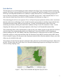
focus on the lower watershed, containing the Deep Creek WRP “project reach,” which includes about 20.7 river
miles from the United States Forest Service (USFS) boundary to the Missouri (see figure 1).
This monitoring plan will serve two purposes. First, it will provide project partners the ability to draw conclusions
about the effectiveness of the Deep Creek watershed restoration project and assess whether targets outlined in the
Watershed Restoration Plan (WRP) are being achieved. Second, it will build upon the efforts of previous
monitoring assessments, allowing for trends in the condition of Deep Creek to be evaluated over time. See the
Sampling and Analysis plan for a thorough explanation of the Deep Creek Watershed Restoration Plan.
These monitoring efforts will be implemented over the next ten years with the support of data collectors Jim Beck,
Associate Supervisor and monitoring volunteer for Broadwater Conservation District’s (BCD), Ron Spoon,
Fisheries Biologist for MT Fish, Wildlife, and Parks, Natural Resource Conservation Service (NRCS) Townsend
Field office employees, and present and future Big Sky Watershed Corps (BSWC) members and/or MSU interns.
If local volunteer’s sign up for this project and are properly trained in data collection methods in future years, their
efforts may be included in this study.
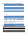
The techniques described herein depict the methods for data collection for each monitoring parameter addressed in
the SAP. All who collect data for the Deep Creek Watershed Monitoring Program are encouraged to use this as a
reference during sampling events.
Figure 1 – Deep Creek watershed and depiction of project reach
3