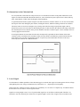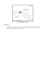
1
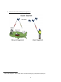
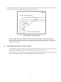
The Field Operator is to record the following information: horizontal distance and the direction (left or right) perpendicular to the direction of travel. The maximum linear offset (i.e. horizontal distance) allowable is _____ meters. Linear offset distances are to be checked and adjusted periodically. 12. It is required that supplemental traverses meet these following rules: The supplemental traverse is to begin and end on physically marked High-Significance GPS static points (PoC and PoT). The distance traversed is to be less than _______ meters. The supplemental traverse is to close between the GPS PoC and PoT by ___ meters+1:___00_ of the linear distance traversed. The supplemental traverse is to be balanced between the GPS PoC and PoT by an acceptable method (i.e., compass rule adjustment). 13. Physical reference markers are to be established every _____ meters along linear features (enter N/A if not applicable). These markers must adhere to contracting Agency standards, or be accepted before the work commences. 14. It is required that static point features be collected at all physical reference markers. These static point features are to be collected as STANDARD / HIGH (circle one) Significance points. 15. It is required that the GPS receiver’s default Signal to Noise Ratio (SNR) mask (6) for high accuracy be used. This CAN/ CANNOT (circle one) be relaxed during traversing of linear features. VII. GPS REFERENCE STATIONS 1. If the Contractor chooses to establish or use a previously established reference station and not a CORS Base station then it must be monumented (physically marked) to allow the contracting Agency or other Contractors to re-occupy the same location. Physical reference marks are to be left and the station referenced using adjacent features (i.e. road intersections, sign posts, bearing trees, etc.) to assist in the future location, and in determining that it has remained undisturbed. Suitable markers include iron bars driven into the soil, spikes in asphalt or concrete, or other markers that the Contractor and Agency determine will remain stable during and, for a reasonable time, after project completion. 2. It is required that the separation distance between the GPS Reference Station and field receivers be less than _____ kilometers, or the separation distance used during Validation, whichever is less. 3. The minimum elevation angle/mask of the GPS Reference Station should be 10 degrees. 4. If real-time corrections are used, it is required that the Contractor validate the GPS Reference Station according to accepted industry procedures. 5. If real-time corrections are used, it is required that the RTCM-Age of the rover GPS system not exceed _____ seconds. See Table IV-1: Suggested Maximum RTCM Correction Age Settings for information on correction ages appropriate for various accuracies. VIII. PROCESSING AND QUALITY CONTROL 1. All GPS positions are to be corrected by standard differential GPS methods (pseudorange or navigation corrections). If navigation corrections are used, the same set of GPS satellites are to be used at the GPS Reference Station as at the field receiver for all corrected positions. 2. If the GPS receiver and/or post-mission software provides the option for dynamic filtering, the filters are to be set to reflect the speed of the operator or vehicle, and the software versions and filter settings are to 82