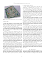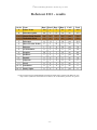
1
Proceedings of the 5th Robotour Workshop held within the Robotics in Education conference Editor: Richard Balogh Sept. 19th , 2010 Bratislava, Slovakia Published by: Robotika.SK, o.z. http://robotika.sk/robotour Credits: Cover design: David Jablonovský Cover photo: Richard Balogh LATEX editor: Richard Balogh using LATEX’s ‘confproc’ class September 2010 5th Robotour Workshop, Bratislava, Slovakia, Sept. 19, 2010 C ONTENTS About the Contest Martin Dlouhý, Jiří Iša Robotour - robotika.cz outdoor delivery challenge Robotour 2010 Pravidla Robotour 2010 Rules Robotour 2010 Team List Robotour 2010 Results 1 7 9 11 13 White papers Pavel Petrovič, Miroslav Nadhajský (Smelý Zajko Team) RoboTour solution as a learned behavior based on Artificial Neural Networks Jiří Iša, Tomáš Roubíček , Jan Roubíček Eduro Team Tomáš Ondráček, Jan Najvárek, Pavel Brzobohatý, Pavel Černocký, David Herman, Jiří Zbirovský, Vojtěch Robotka Roboauto Quido D. Herman, T. Ondráček, J. Najvárek, F. Orság, M. Drahanský (Roboauto Team) Robot pro Robotour 2010 Lukáš Čížek (Robozor Team) Robot Vector 15 21 25 33 39 Presentations Robozor České Budějovice 45 Radioklub Písek 47 Brmlab Praha 51 Tatran Team Trenčín 53 List of Authors 55 – iii – 5th Robotour Workshop, Bratislava, Slovakia, Sept. 19, 2010 – iv – 5th Robotour Workshop, Bratislava, Slovakia, Sept. 19, 2010 Robotour - robotika.cz outdoor delivery challenge Jiřı́ Iša Faculty of Mathematics and Physics, Charles University in Prague Malostranské náměstı́ 25, 118 00 Praha 1 Czech Republic Email: [email protected] Abstract—In this paper, we present an international contest for autonomous robots: Robotour – robotika.cz outdoor delivery challenge. The main task is a navigation in real-world situations. First three years were held in park Stromovka, Prague, Czech Republic and raised an interest of many teams, media and general public. Last year, the contest started to migrate. To our knowledge, there is no similar European outdoor contest for fully autonomous machines. Note, that there are some common features with American Mini Grand Challenge and a younger Japanese Real World Robot Challenge. The rules of Robotour are described in more detail together with experience gained over the past four years – both from the organizers’ and the participants’ point of view. Keywords: autonomous robots, outdoor, international competition I. I NTRODUCTION Competitions such as Eurobot [1] and DARPA Grand Challenge [2] have repeatedly shown that both young students and senior researchers are attracted by competitive research environments. Autonomous robotics is a multidisciplinary domain which offers educational opportunities and interesting realworld research topics. In 2004, the American Defense Advanced Research Projects Agency (DARPA) organized the first Grand Challenge. The goal of DARPA was to foster a research in fully autonomous vehicles. In the first year, only 11.78 km of the 240 km long route were completed by the best team. Already in the second year of the competition (2005), five vehicles finished the 212 km long route. This shows a tremendous impact the challenge has had on the field of fully autonomous ground vehicles. Since 1994, the Eurobot competition attracts many young people (more than 2000 in year 2010) [3]. Eurobot has successfully shown how an international competition can be used to teach young people how to cooperate and how to develop complex systems. In 2006, the Robotour – robotika.cz outdoor delivery challenge has been founded. In our opinion, the large gap in complexity between Eurobot-like competitions (e.g. RobotChallenge [4], Istrobot [5] and other) and competitions like DARPA Grand Challenge needed to be bridged. In about the same time, other organizers felt similar insufficiency and more competitions were born. Since 2003, Field Robot Event focuses on the agricultural automation [6]. Since 2006, European Land Robotic Trial allows research teams and industrial companies Martin Dlouhý MapFactor s.r.o. Štefánikova 24, 150 00 Praha 5 Czech Republic Email: [email protected] to demonstrate their unmanned outdoor systems in realistic scenarios and terrains [7]. One year after Robotour – in 2007 – Tsukuba Real World Robot Challenge (RWRC) took place in Japan for the first time [8]. Since 2009, a similar straight line outdoor challenge takes place in Pı́sek, Czech Republic [9]. Robotour – robotika.cz outdoor challenge is focused on autonomous ground vehicles and their orientation in the realworld outdoor environment. The robots perform a delivery task in complex environments of city parks. They are not allowed to leave paved roads. Participants of various background are welcome. In the previous years, students from high schools, university researches and hobbyists took part. In this paper, we describe the Robotour – robotika.cz outdoor delivery challenge. General rules are covered in Section II. In Section III, we share experience obtained from the organizers’ point of view. Reflections of the participants are captured in Section IV. II. RULES A. Historical Overview The rules for each year change slightly and the contest becomes more and more challenging every year. The unified theme of all years is robot’s ability to autonomously navigate in outdoor environments and to move payload from one place to another. The robots have to be fully autonomous, which means that after a task entry they have to control themselves. Since the first year, the basic requirement is to navigate on paved roads in the park without leaving them – similar to cars not leaving the streets. In the second year, a possibility of robot cooperation was introduced. In the third year, obstacles were added and robots had to deal with them successfully. In the fourth year, robots did not know exactly their start position and had to deal with obstacles more carefully. The fifth year of this contest should be a next step towards smarter and more autonomous robots. In contrast to the previous years, the robots get only a map and coordinates of the destination. The robots should be able to navigate around the park even if they have never been there before. The map and the destination should be the only information the robots get before the start. Robot successfully solving this task should be able to demonstrate its ability with a corresponding map in any park. –1– 5th Robotour Workshop, Bratislava, Slovakia, Sept. 19, 2010 Fig. 1. A simple map of the Lužánky park in Brno given to the participants in 2009. B. Detailed Rules 1) Task: The task for the robots is to deliver payload in a given limit of 30 minutes to a destination as far as 1 km. Robots must be fully autonomous, not leave a road and choose correct path on junctions. The starting place, starting time and the destination will be the same for all the robots. 2) Map: Vector map of footpaths in a park will be based on a vectorization of an ortophotomap and teams could improve it further. The basic idea is taken from Open Street Map [10]. A robot is allowed to use only this shared map – all other maps are prohibited! 3) Robots: A team can deploy multiple robots this year, but only a single designated one is used to compute a score. Every robot must have an emergency stop button, which stops its motion. The button must be easily accessible, red and must form a fixed part of the robot (aka Big Red Switch), so it could be used in a case of a danger. The team must show that it is easy to manipulate with the robot – two people must be able to carry it several tens of meters. There is also a minimal size – robot has to carry 5l beer barrel (at least an empty one). 4) Leaving the Road: The robots are expected to stay “on the road” which means to stay on the paved passage ways. If any robot leaves the road, its trial ends. The team has to take care of their robot and remove it immediately. 5) Obstacles: There could be obstacles on the road. Besides natural obstacles like benches there could also be artificial obstacles. A typical (artificial) obstacle is for example a figurant, a banana paper box or another robot. Robots must not touch an obstacle. Contact with an obstacle means an end of a trial. The robot may stop in front of an obstacle and visually or acoustically give a notice. Note, that the robot has to detect, that the obstacle is no longer present. 6) Robots Interaction: Situations, in which a faster robot catches up with a slower one, will not be explicitly handled. The faster robot can handle the slower robot as an obstacle, i.e. avoid it or wait until the “obstacle” disappears. In general, the road rules will be respected: right of way, avoidance –2– to the right, passing on the left. 7) Start: All robots will start from the same park road simultaneously. A minimum width of this road is 3 meters. The starting area for each team will measure approx. 1.5 × 1.5 meters. Starting areas will follow one after another on one side of the road. Within the starting area, each team can place its robot as they see fit. The order of the robots on the start is given by their results in the previous round (a better robot will be closer to the destination). The order in the first round will be given by the order of successful homologation. Robots start automatically via their internal timers. During the last minute before the start, no interaction with the robot is allowed. 8) Score: The team, whose robot manages to proceed along the route best, wins. The aerial distance of the last position of the robot (leaving the road, a collision or a timeout) to the destination is critical. For every meter towards the destination, a team gets one point. If the team carries a payload, its score is doubled (“points for the payload”). Each robot can carry only one “payload”. A 5l beer barrel (full) serves as a payload. In every round, a robot can obtain points at most equal to twice the aerial distance of the start and the destination. 9) Organization: The contest will consist of four trials for each team. The start and destination will be different for every trial. The selected destination will be announced to all teams 10 minutes before the start. The speed of the robots is not important (actually, it is limited to 2.5 m/s). All points gained during all trials will be summed together. The trial starts at a specified time and ends after 30 minutes. The robot must leave the starting area within 10 minutes of the start. If the robot does not move for 60 seconds its trial ends. Each team has to arrange for one person familiar with the rules that will be part of the referee team during the competition. 10) Homologation: A team can participate in the contest only if it is able to score at least one point. Another necessary condition is an ability to travel along a 10 meters long route fragment without a collision with any obstacle. The starting procedure will be tested (the automatic start) as well as the functionality of the emergency stop button. Usage of liquids, corrosive or pyrotechnic material as well as live beings is strictly prohibited. Every robot has to be accompanied by a team member, older than 18 years, who is fully responsible for the behavior of the robot. 11) Technical Documentation: Every team has to provide basic technical documentation about their robot (for presentations, general public and journalists). Three winning teams will be asked for a more detailed description for a website presentation and to make the entry of novices in the following years easier. III. O RGANIZATION Robotour is organized as a three-day event (Friday to Sunday). Friday is dedicated to the testing, clarification of rule details and homologation. During the homologation, we want to make sure that robots are not dangerous, have a functional 5th Robotour Workshop, Bratislava, Slovakia, Sept. 19, 2010 emergency stop button and are able to gain at least one point in the contest. Saturday is the contest day. Finally, there is a workshop on Sunday. It is after the contest, so the competitors have a fresh experience with their robots and algorithms. They are also not stressed any more and thus this is a good moment for sharing knowledge. We started to enforce this three-day template after the first competition in 2006. That competition ended on Saturday and most teams left without letting us and other teams know what has worked and what has not. What was even more important was that teams left exhausted from the programming marathon and one team had a car accident on the way home. Since the following year, the workshop is mandatory. The Robotour contest is relatively self-supporting and the expenses are minimal. There is no special playground – a public park is used instead. There is no need for renting a hall because the event takes place outside. To be precise, some room is necessary as a base for the teams especially in bad weather conditions. It is recommended to have a partner who provides this place, like Planetarium Praha in the first park Stromovka did. A good idea is also a combination with an exhibition of robots and a related technology parallel to the contest. There is no registration fee, but the teams have to take care of catering and pay an accommodation.1 Small items remain on the bill: leaflets printing, diplomas, cup for the winners, and a Saturday night dinner. The dinner is usually sponsored and the goal is to unite the teams and give them a chance to relax a little bit after the contest. Note, that prices are rather symbolic, which lowers expenses on one side and also reduces a potential rivalry between the teams. A. Duties over the Year The first task of the organizers is a precise specification of rules for the next contest. They are presented on the robotika.cz website in Czech and English languages. The core remains the same (autonomously navigate in a park) and the changes are usually a consequence of a discussion at the workshop and experience gained. The second task is to ensure an affordable accommodation for a relatively large group of people (50 people needed accommodation in 2009). An agreement with a university dormitory serves well. The reservation must be performed usually a month in advance and that defines a clear deadline for the registration of the teams. Finally, it is necessary to find an interesting park, manage permission for the contest day and find building with large enough room(s) for team base with many electric outlets. B. Experience of the Organizers There were couple lectures we have learnt over the last four years organizing Robotour (and previously several years of organizing Czech Cup of Eurobot). The basic scenario was already mentioned and serves good and is worth a recommendation. What has changed over the years are two major 1 Accommodation is usually partially or fully sponsored. Fig. 2. Robot of the R-team (left) leading the allied robot of RobSys (right). trends: the number of teams is increasing and the task is getting more difficult. In the first case, we tried to find some optimal timetable of the rounds and we are still not satisfied. What suits the teams does not suit a general audience and vice versa. This year, we will start all the robots from one place simultaneously, which could be attractive for spectators, but may cause problems to many teams. The task complexity is another issue. Beginners have a harder position to enter the contest every year. For 2010, we discussed a new category (WagonOpen), but we will probably cancel it. The reason is a new, for the beginners with outdoor robots highly recommended contest “Robotem rovně” (Robot, go straight!) in Pı́sek. In Pı́sek, the task is to navigate as far as possible on a 3 meters wide and 300 meters long park road. This is exactly the first stage which is necessary to enter the Robotour contest. IV. R EFLECTIONS A. Questions To reflect an influence the competition has had on its participants, we have asked some of the past successful teams few questions: 1) What did you expect from the competition? 2) What did the competition give you? 3) What were you disappointed with? B. Asked Teams The following teams were asked: • Propeler-team, Opava: A group of high school students, who placed 2nd in 2006. • LEE, Prague: Researchers and students from Czech Technical University in Prague. Winners of the year 2008 and the year 2009. • R-team, Rychnov nad Kněžnou: A team of a high school teacher. Since 2010, he organizes RobotOrienteering in Rychnov nad Kněžnou. R-team finished 2nd in 2008 (in a coalition with the RobSys team, see Figure 2). • Roboauto, Brno: A self-funded group of researchers, which ranked 2nd in 2009. –3– 5th Robotour Workshop, Bratislava, Slovakia, Sept. 19, 2010 • Radioklub Pı́sek, Pı́sek: Hobbyists and professionals, who also teach electronics in a club. Radioklub Pı́sek got a 3rd place in 2009. Since 2009, the club organizes Robotem rovně (mentioned in Section III). C. Answers 1) What did you expect from the competition?: • Propeler-team: – The competition motivated us to build our first robot. – Having almost no restriction on the dimensions of the robot allowed for a simple construction – We could use a notebook, get an image from a camera and use a bought chip to control the motor and the servo (we did not understand microchips and servos at that time). • LEE: – We wanted to see a comparison of several approaches to the mobile robotics. – The competition gives us an opportunity to have our solution judged in an unbiased fashion. • R-team: – After Istrobot and Eurobot, I wanted to try something new. • Roboauto: – The competition served as a motivation to finish a functional version of algorithms and of the robot. – We wanted to present our results to a general public. – We expected to meet with a like-minded community. • Radioklub Pı́sek: – After seeing the robots in 2007, we believed we could do better. 2) What did the competition give you?: • Propeler-team: – We met people in the same domain of interest, saw their approach and other technology. – Every year, we have a motivation to catch up with our first result. • LEE: – We have seen, how a relatively simple solution (by R-team) can solve a given task. – We realized that the increasing accuracy of hardware and sensors can have a huge impact on the accuracy of simultaneous localization and mapping. – We have been shown, how important it is to deal with the technical details and with the reliability of the robots. • R-team: – I have learned that even the hardware is not fully reliable. Indoor robots do not suffer from such problems. – I realized how difficult the task is, even though I have expected some difficulties even beforehand. • Roboauto: –4– – It has fulfilled our expectation. – The competition gave us a practical experience with deploying a robot. – We have got an inspiration for further improvements of the hardware and algorithms. – We feel in touch with people with similar interests. • Radioklub Pı́sek: – We realized the competition is not as simple as it seemed for the first look and few others. 3) What were you disappointed with?: • Propeler-team: – We are not really disappointed: When the robot works, everything is fine. – Answering the question “What does the robot do?” is difficult, when the task difficulty is not obvious. • LEE: – Although there is a lot written by the competitors at robotika.cz, every year someone new comes and repeats previous mistakes. • R-team: – In my opinion, the competition has become too difficult. Only one or two best teams can fully cope with the rules. • Roboauto: – Problems with a reliability and with a robustness are bigger than we have expected. – We are disappointed with only a small media attention. – We hoped to get an attention of potential sponsors or future team members, which has not happened so far. • Radioklub Pı́sek: – We are sad that the cooperation of multiple robots is not encouraged any more. We have learned several interesting things doing that. On the other hand, as the competition evolves, it does not suffice to copy a solution from the previous year. V. S UMMARY We have introduced Robotour – robotika.cz outdoor delivery challenge, its rules and their evolution over the time. We share experience gained while organizing several years of the competition and show several patterns worth following. The competition has been successful in attracting people to robotics and giving them an opportunity to learn. The contestants enjoy a chance to meet others, exchange ideas and compare their approaches in an independent manner. As the competitors note, while seemingly simple, the competition became difficult to participate in. This in turn led to a creation of two new robotic competitions in Czech Republic, which differ in the level of difficulty. Currently, there exists an evolutionary path for a person interested in robotics through these outdoor competitions up to Robotour and possibly even further. 5th Robotour Workshop, Bratislava, Slovakia, Sept. 19, 2010 R EFERENCES [1] Eurobot, “Contest for amateur robotics,” http://eurobot.org/, 1997. [2] DARPA, “Grand Challenge,” http://www.darpa.mil/grandchallenge/, 2004. [3] David Obdržálek, “Eurobot 2010,” Robot Revue, May 2010. [4] Robot Challenge, “Indoor robotic competitions,” http://robotchallenge.org, 2010. [5] Istrobot, “Contest for amateur robotics,” http://robotika.sk/, 2010. [6] Field Robot Event, “Agricultural robotic competition,” http://fieldrobotevent.de, 2010. [7] ELROB, “1st European Land-Robot Trial,” http://www.elrob2006.org/, 2006. [8] Real World Robot Challenge, “Outdoor robotic challenge,” http://www.ntf.or.jp/challenge/, 2009. [9] Robotem Rovně, “Outdoor robotic challenge,” http://www.kufr.cz/view.php?nazevclanku=robotem-rovne2010&cisloclanku=2010020002, 2010. [10] Open Street Map, “Public mapping activity,” http://www.openstreetmap.org, 2010. –5– 5th Robotour Workshop, Bratislava, Slovakia, Sept. 19, 2010 –6– 5th Robotour Workshop, Bratislava, Slovakia, Sept. 19, 2010 Robotour 2010 - pravidla Martin Dlouhý a Zbyněk Winkler http://robotika.cz IV. Abstrakt – Pátý ročník soutěže autonomních outdoor robotů se bude konat 18. září 2010 na Slovensku v jednom ze tří předvybraných parků v Bratislavě. Na rozdíl od předešlých ročníků roboti dostanou pouze mapu a souřadnice cíle. Roboti nebudou přesně znát svoji startovní polohu a interakce s operátorem se omezí na zadání cíle. Robot úspěšně řešící tuto úlohu by měl být schopen demonstrovat své schopnosti v jakémkoli parku s odpovídající mapou. I. CÍL Cílem soutěže Robotour je podpořit vývoj robotů schopných dopravit vás třeba ráno do práce nebo vám přivézt stavební materiál, co jste si právě objednali v online obchodě. Cesta k takovému cíli nebude ani jednoduchá ani krátká, ale věříme, že výsledek bude stát za to. II. MAPY V předchozích ročnících bylo hojně využíváno mapování soutěžního prostřední před vlastní soutěží. Tyto mapy sahaly od jednoduchých záznamů ujeté vzdálenosti (odometrie) a směru (kompas) až po netriviální analýzu obrazu z kamery a zapamatování si význačných bodů. Takový způsob navigace ale předurčoval robotům pohyb pouze tam, kde jeho tvůrce strávil často i několik dnů relativně namáhavým a vyčerpávajícím vytvářením velmi specifických map. Je poměrně zřejmé, že vytvořit tímto způsobem mapu pro robota na cestu například z Písku do Opavy, nebude práce zrovna na jedno odpoledne. Na druhou stranu ale existují dostupné mapy, na jejichž tvorbě se podílí mnoho lidí a díky tomu mají stále lepší pokrytí. To je možné jen proto, že se všichni shodli na tom, jak má taková mapa vypadat. Pokud má být malá skupina lidí někdy schopná postavit robota schopného pohybu v „našem světě”, je třeba aby tento robot využíval „naše mapy” — to jest mapy, které je schopen vytvořit i někdo jiný než autor robota. A to jsme se rozhodli v tomto ročníku podpořit… III. MOTIVACE PRO ROK 2010 Pátý ročník by měl být dalším krokem na cestě k chytřejším a autonomnějším robotům. Na rozdíl od předešlých ročníků roboti dostanou pouze mapu a souřadnice cíle. Roboti nebudou přesně znát svoji startovní polohu a interakce s operátorem se omezí na zadání cíle. Robot úspěšně řešící tuto úlohu by měl být schopen demonstrovat své schopnosti v jakémkoli parku s odpovídající mapou. Stejně jako v minulých ročnících jsou podporováni robustnější roboti schopní převážet náklad. Pro zvýšení divácké atraktivity bude start robotů hromadný. Dále bude zavedena samostatná kategorie WagonOpen pro podpoření začínajících týmů. PRAVIDLA Úkol Úkolem robotů je v zadaném časovém limitu 30min dopravit náklad do cíle vzdáleného až 1km. Roboti musí být plně samostatní, nesjíždět z cesty a správně se rozhodovat na křižovatkách podle zadané mapy. Místo startu i místo cíle bude pro všechny roboty stejné. Mapa Vektorová mapa chodníků v parku bude vycházet z vektorizace ortofotomapy a týmy si ji mohou dále zpřesňovat. Základní idea je převzata z Open Street Map. Ve výsledku budou moci roboti použít pouze tuto sdílenou mapu — jakékoli jiné mapy jsou zakázány! Roboti Tým může letos nasadit pouze jednoho robota. Každý robot musí mít EMERGENCY STOP tlačítko, které robota zastaví. Tlačítko musí být snadno přístupné, červené a musí být pevnou součástí robota (aka Big Red Switch), aby se v případě hrozícího nebezpečí dalo snadno stisknout. S robotem musí být možnost snadno manipulovat: libovolné dvě dospělé osoby ho mohou odnést několik desítek metrů. Je zároveň definovaná minimální velikost — na robotovi musí být během celé soutěže umístěn 5l pivní soudek (alespoň prázdný). Vyjetí z cesty Je dovoleno se pohybovat pouze po parkových cestičkách. Pokud robot sjede z cesty, aktuální pokus pro něj končí. O jeho včasné odklizení se musí postarat soutěžící tým. Překážky Na trase se mohou nacházet překážky. Kromě překážek přirozených (lavičky atp.) mohou být na trať umísťovány i překážky umělé. Za typickou (umělou) překážku se považuje například figurant, papírová krabice od banánů či jiný robot. Roboti nesmí vejít v kontakt s překážkou. Kontakt s překážkou znamená ukončení pokusu. Robot může před překážkou zastavit a vizuálně či zvukově upozornit, že překážka byla detekována. Fakt, že překážka už není přítomná musí roboti detekovat sami. Interakce robotů Situace, kdy rychlejší robot dojede robota pomalejšího, nebude nijak zvláštně řešena. Rychlejší robot se může k pomalejšímu zachovat například jako k překážce — tj. objet ho nebo počkat, až odjede sám. Obecně budou respektována pravidla silničního provozu: přednost zprava, vyhýbání se vpravo, předjíždění vlevo. Start Všichni roboti budou startovat současně na jedné z parkových cest (všichni stejné). Minimální šířka cesty, na které se bude startovat, je 3 metry. Startovní oblast pro jeden tým bude mít velikost cca 1.5x1.5 metru. Startovní oblasti budou umístěny těsně za sebou při jedné straně cesty. V rámci startovní oblasti může tým umístit robota podle vlastního uvážení. Pořadí robotů na startu bude dané výsledky v předešlém kole (lepší robot bude blíže k cíli). V prvním kole bude pozice určena pořadím úspěšné homologace. Roboti startují automaticky pomocí vnitřních časovačů. Minutu před startem už nesmí docházet k žádné interakci s robotem. –7– 5th Robotour Workshop, Bratislava, Slovakia, Sept. 19, 2010 Bodování Vyhrává tým, jehož robot bude trasu nejlépe zdolávat. Rozhodující je vzdušná vzdálenost poslední pozice (vyjetí z cesty, kolize či vypršení časového limitu) k cíli. Tým získává 1 bod (tzv. „bod za cestu”) za každý metr směrem k cíli = vzdálenost(start,cíl)-vzdálenost(konečná pozice,cíl). Za vezení nákladu získává tým dvojnásobek („body za náklad”). Každý robot může vézt jeden „náklad”. Nákladem se rozumí 5l pivní soudek (plný). V daném kole tedy robot může získat nejvýše počet bodů roven dvojnásobku vzdušné vzdálenosti start-cíl. Pokud robot neopustí startovní oblast, získá 0 bodů. Organizace Soutěž bude mít 4 kola. Pro každé kolo bude vybrán jiný start a cíl. Vybraný cíl bude oznámen 10 minut před startem kola. Rychlost v této soutěži nehraje roli (je omezena na 2.5m/s). Do celkového výsledku se sčítají body za všechna kola. Kolo začíná vždy v určený čas a končí po 30 minutách. Robot musí opustit startovní oblast nejpozději do 10 minut od startu. Pokud se robot mimo startovní oblast nebude 60 sekund pohybovat, bude aktuální pokus ukončen. Každý tým musí zajistit jednu osobu znalou pravidel, která bude během soutěžního dne patřit do týmu rozhodčích. Homologace Tým se může zúčastnit soutěže, pokud ukáže, že je schopen získat alespoň jeden bod. Nutnou podmínkou je projet desetimetrový úsek bez kontaktu s překážkou. Testována bude startovací procedura (automatický start) a funkčnost EMERGENCY STOP tlačítka. Použití tekutin, žíravin, pyrotechnických materiálů a živých bytostí je zakázáno. Každý robot bude během jízd doprovázen jednou osobou z týmu, starší 18 let, která je za jeho chování zcela zodpovědná. Technická dokumentace Každý tým dodá ke svému robotu (robotům) základní technickou dokumentaci (pro prezentace, veřejnost a novináře). Vítězné týmy (1. až 3. místo) pak budou požádány o podrobnější dokumentaci pro webovou prezentaci a tedy zjednodušení zapojení nováčků do soutěže v následujícím roce. Kategorie VagónkyOpen roboti BODY a TAIL z minulých ročníků se mohou zůčastnit nové kategorie „WagonOpen”. Její hodnocení bude nezávislé na hlavní soutěži a hlavní motivací je umožnit zapojení nováčků. Tato soutěž bude mít 3 kola a cílem bude se udržet za vedoucím robotem. Každý robot (vagónek) bude mít rampu na umístění majáčků pro napojení více robotů v kolonu. Detaily budou upřesněny v FAQ1. Omezení rozměrů a bodování za inteligenci a za náklad –8– bude převzaté z hlavní soutěže tak, aby hardware robota mohl být využit v dalším ročníku v hlavní kategorii. V. • • • • • • • • • • • • ODLIŠNOSTI OPROTI MINULÉMU ROČNÍKU Hromadný start všech robotů z jednoho, předem neznámého, místa. Je zakázáno mapovat si soutěžní prostor před vlastní soutěží. Místo toho mohou týmy využívat mapu, na jejíž tvorbě se mohou aktivně podílet. Kolona robotů HEAD, BODY a TAIL již není nijak podporována. Každý robot musí být schopen uvést 5l sud piva (alespoň prázdný). Přesná poloha cíle bude známá 10min před startem. Automatický start pomocí časovače. Místo PAUSE tlačítka bude pouze vyžadováno EMERGENCY STOP tlačítko, které může kdokoliv použít v případě nebezpečné situace — například poruše robota. Jeho stisk znamená ukončení pokusu. Za Big Red Switch není možné považovat klávesnici (ano, je pozoruhodné, že i po těch letech to pořád některým týmům není jasné). Prostě dejte na svého robota snadno dostupný červený vypínač. Bez odpovídajícího BRS nebude robot do soutěže připuštěn. Není omezení na velikost překážky. Mohou tedy nastat situace, kdy bude celá cesta blokovaná a překážku není možné objet. Nebude k dispozici referenční maják. Nebude kategorie „volná jízda”. Troubit na překážku je i nadále možné, ale efekt to bude mít pouze v případě, kdy je překážkou například zvědavá babička. Naopak lavička (přes zvukovou podobnost obou zareagovat cizí robot nebo krabice od banánů. 5th Robotour Workshop, Bratislava, Slovakia, Sept. 19, 2010 Robotour 2010 - rules Martin Dlouhý a Zbyněk Winkler http://robotika.cz Abstract – Fifth year of this autonomous outdoor robot contest will be held on 18th September 2010. It will take place in Slovakia in one of the preselected parks in Bratislava. In contrast to previous years robots will get only map and coordinates of destination. Note, that robots will not know their exact starting position and interaction with operator will be reduced to entering destination. Robot successfully solving this task should be able to demonstrate its navigation in any park with corresponding map. I. GOAL The objective of the Robotour contest is to encourage development of robots capable of transporting you to work in the morning or to deliver the building material you have just purchased in an online shop. The path to this goal is neither easy nor short, but we believe that the outcome is worth it II. MAPS In the previous years there was an abundant mapping of the environment shortly before the contest itself. These maps spread from simple records of the traveled distance (odometry) and direction (compass) to a non-trivial image analysis saving notable points along the way. This technique of navigation restricts the robots only to places where their creator spent often several days of relatively tiring and exhausting work to build a very specific map. It is relatively clear, that to create a map for a robot to travel from Písek to Opava won't be a one afternoon job with this technique. But there is a map available to the general public, where many people cooperate on its creation and this way the coverage is getting better every day. This is possible only because everybody agreed on how the map should look like. If ever a small group of people should create robot able to move in “our world” it is necessary that this robot uses “our maps” — this means to use maps created by somebody else than the robot's author. This is something we would like to endorse this year... III. MOTIVATION FOR YEAR 2010 The fifth year of this contest should be a next step towards smarter and more autonomous robots. In contrast to the previous years robots get only a map and coordinates of the destination. The robots should be able to navigate around the park even if they have never been there before. The map and the destination should be the only information the robots get before the start. Robot successfully solving this task should be able to demonstrate its ability with a corresponding map in any park. Robust robots able to carry a payload are preferred as in previous years. The start will be concurrent from one place to increase spectators attractiveness. There will be also new category WagonOpen to support novice teams. IV. RULES Task The task for the robots is to deliver payload in given 30 minutes time limit to destination as far as 1km. Robots must be fully autonomous, not leave the road and choose correct path on junctions. The place of start and destination will be the same for all robots. Map Vector map of footpath in park will be based on vectorization of ortophotomap and teams could further improve it. The basic idea is taken from Open Street Map. At the end robot could use only this shared map — all other maps are prohibited! Robots Team can deploy only one robot this year. Every robot must have EMERGENCY STOP button, which stops its motion. The button must be easy accessible, red and must be fixed part of the robot (Big Red Switch), so it could be used in case of danger. The team must show that it is easy to manipulate with the robot — two people must be able to carry it several tens of meters. There is also minimal size — robot has to carry 5l beer barrel (at least an empty one). Leaving the road The robots are expected to stay “on the road” which means to stay on the paved passage ways. If any robot leaves the road, the trial ends. The team has to take care of their robot and remove it immediately. Obstacles There could be obstacles on the road. Besides natural obstacles like benches there could be also artificial obstacles. A typical (artificial) obstacle is for example a figurant, a banana paper box or other robot. Robots may not touch an obstacle. Contact with an obstacle means end of the trial. The robot may stop in front of the obstacle and visually or acoustically give notice. Note, that the robot has to detect, that the obstacle is no longer present. Robots Interaction In the cases where a faster robot catches up a slower one won't be explicitly handled. The faster robot can handle the slower robot as an obstacle, i.e. avoid it or wait until the „obstacle” disappears. In general the road rules will be respected: right of way, avoidance to the right, passing on the left. Start All robots will start simultaneously from the same park road. A minimum width this road is 3 meters. Start area for each team will have approx. 1.5x1.5 meters. Start areas will follow one after another on one side of the road. In the start area each team can place its robot as they see fit. The order of robots on start is given by the results the in previous round (a better robot will be closer to the destination). The order in the first round will be given by the order of successful homologation. Robots start automatically via their internal timers. A minute before the start is allowed no interaction with the robot. –9– 5th Robotour Workshop, Bratislava, Slovakia, Sept. 19, 2010 Score The team whose robot manage best to proceed along the route wins. Critical is the aerial distance of the last robot position (leaving the road, a collision or a timeout) to destination. For every meter towards the destination team gets one point. If the team carries payload it is awarded twice (“points for the payload”). Each robot can carry only one “payload”. Payload is 5liter beer barrel (full). In every round a robot can get at most twice the aerial distance of the start and the destination. Organization The contest will consist of 4 trials for each team. The start and destination will be different for every trial. The selected destination will be announced to all teams 10 minutes before the start. The speed of the robots is not important (actually it is limited to 2.5m/s). All points gained during all trials will be summed together. The trial starts at a specified time and ends after 30 minutes. The robot must leave the start area within 10 minutes of the start. If the robot does not move for a 60 second its trial ends. Each team has to arrange for one person familiar with the rules that will be part of the referee team during the competition. Homologation A team can participate in the contest if it is able to score at least one point. Necessary condition is the ability to travel 10 meters long route fragment without collision with an obstacle. The start procedure will be tested (automatic start) as well as the functionality of the EMERGENCY STOP. Usage of liquids, corrosive, pyrotechnic material and live beings is strictly prohibited. Every robot has to be accompanied by a team member, older 18 years, who is fully responsible for the robot behavior. Technical documentation Every team has to provide basic technical documentation about their robot (for presentations, general public and journalists). Three winning teams will be asked for more detail description for website presentation and easier entry of novices in the next year. Category WagonOpen Robots BODY a TAIL from previous years can participate in a new category „WagonOpen”. Scoring of this category will be independent of the main contest and the primary motivation is to give a chance to novice teams. This contest will have 3 rounds and the goal is to follow a leading robot. Every robot (wagon) will have a ramp for placing beacons to link together several robot in a convoy. • Details will be specified in FAQ1. Robot restrictions and score for intelligence and payload will be adopted from main contest, so that the robot hardware could be used for the next year participation in the main category. – 10 – V. BASIC DIFFERENCES AGAINST THE PREVIOUS YEAR • Simultaneous start of all robot from one, beforehand unknown, place. • It is prohibited to map contest area before contest itself. Teams can instead use shared map on which creation they can actively participate. • Convoy of robots HEAD, BODY a TAIL is not supported. • Every robot must be able to carry 5l barrel of beer (at least empty). • Exact position of destination will be known 10min before start. • Automatic start via timer. • Instead of PAUSE button only EMERGENCY STOP button is required. It could be used in any dangerous situation — for example in case of robot failure. Pressing it means end of trial. • For the Big Red Switch is not possible to use a keyboard (yes, it is remarkable, that still after several years some teams do not get it). Just attach to your robot easily accessible red switch. Without this BRS robot won't be accepted to the contest. • There is no restriction of an obstacle size. There could be even cases, when the whole path is blocked and it is impossible to avoid it. • There will be no extra beacon available. • There will be no category „free style”. • It is still possible to honk on an obstacle, but it will have effect only in cases of curious grandma. On the other hand bench won't notice honking. The same holds for other robots or banana paper boxes. 5th Robotour Workshop, Bratislava, Slovakia, Sept. 19, 2010 Robotour 2010 – Team List BestBase (Bratislava) Daniel Žilinec Róbert Najvirt Brmlab (Prague) Michal Tuláček Václav Hula CGS Robotics (Italy) Matteo Unetti Nicola Giordani Torquato Cecchini Eduro (Prague) Tomáš Roubíček Jiří Iša Jan Roubíček Istrobotics (Bratislava) Pavol Boško Peter Boško Odysseus (Prague) Jaroslav Halgašík Lenka Mudrová Matouš Pokorný Petra Kaplanová Propeler (Opava) Tomáš Kotula Martin Kotula Eva Kotulová Roboauto (Brno) Jan Najvarek Tomáš Ondráček Pavel Brzobohatý Vojtěch Robotka Roboauto Quido (Brno) David Herman Jirka Zbirovský Sirael (Praha) Kamil Řezáč Jaroslav Sládek Robozor (České Budějovice) Martin Kákona Jakub Kákona Martin Povišer Lukáš Čížek Josef Szylar Roman Dvořák Kryštof Celba Radioklub Písek Martin Černý Pavel Hubka Karel Kozlík Milan Říha Antonín Seiner Blanka Seinerová Martin Stejskal Short Circuits (Praha) Pavel Jiroutek Dan Polák Lukáš Polák Smelý Zajko (Bratislava) Pavel Petrovič Miroslav Nadhajský Tatran Team (Trenčín) Michal Kukučka Juraj Ečery Marek Šutliak URPI Team (Bratislava) Marian Kľúčik Michal Bachraty Organizers Martin Dlouhý Zbyněk Winkler David Obdržálek Ondřej Luks František Duchoň Richard Balogh – 11 – 5th Robotour Workshop, Bratislava, Slovakia, Sept. 19, 2010 – 12 – 5th Robotour Workshop, Bratislava, Slovakia, Sept. 19, 2010 Robotour 2010 – results Order 1. 2. 3.-4. (*) 3.-4. (*) 5. 6. 7. 8. 9. 10. 11. 12. 13. 14.-15. 14.-15. Team Run 1 Run 2 Run 3 Run 4 Eduro Team 100 0 73 49 Roboauto Quido 84 0 53 16 Tatran Team Trenčín 28 0 17 23 Radioklub Písek 0 0 1 65 Roboauto 11 11 1 34 Short Circuits Praha 17 2 43 9 Robozor 1 0 0 34 CGS Robotics 0 2 27 0 Propeler 20 2 5 19 BestBase 5 2 3 2 Brmlab 9 0 0 9 Odysseus 0 2 4 11 Sirael 0 0 2 0 Istrobotics 0 0 0 0 Smelý Zajko 0 0 0 0 Full? yes no yes yes yes no yes yes no yes no no no no yes Total 444 153 136 132 114 71 70 58 46 24 18 17 2 0 0 (*) Tatran Team Trenčín and Radioklub Písek delivered full tanks, and the total difference was only 2 meters (under the measurements resolution). So we decided to join these two places. – 13 – 5th Robotour Workshop, Bratislava, Slovakia, Sept. 19, 2010 – 14 – 5th Robotour Workshop, Bratislava, Slovakia, Sept. 19, 2010 Robotour Solution as a Learned Behavior Based on Artificial Neural Networks Miroslav Nadhajský and Pavel Petrovič Department of Applied Informatics, Faculty of Mathematics, Physics and Informatics, Comenius University, Mlynská dolina, 842 48 Bratislava, Slovakia, [email protected], [email protected], Abstract—Our contribution describes a mobile robot platform that has been built for the purpose of the contest Robotour – robotika.cz outdoor delivery challenge. The robot is a standard differential-drive robot with a good quality consumer market digital video camera with a lightweight, but high-performance laptop computer used as the main control board. Supplementary board is used to control motors and sensors of the robot. The robot utilizes a behavior-based architecture and its vision module that is responsible for track-following is utilizing an artificial neural network that was trained on a set of images. This is a novel solution that has not been used in Robotour contest previously, and our early experiments demonstrate promising results. Keywords – robotour, navigation, artificial neural networks, learning robots I. INTRODUCTION Applications of robotics technology in both production and personal use are becoming possible with the development of new materials, motors, sensors and vision, ever decreasing cost of computing and memory capacity, and development of new algorithms and control strategies. Robots must be able to operate in dynamic and unpredictable environments. Therefore, one of the most important challenges to be solved reliably is robot navigation – in both indoor and outdoor environments. The robots must be able to localize themselves on a supplied map, create their own map representations of the explored environment, and they must be able to navigate their environments safely, without colliding with obstacles, or failing to follow the paths, roads, trails, and tracks. The real improvements in the technology typically occur when there is a large motivational pressure to produce a working solution. This might either be a goal to produce a final product, or alternately, with somewhat more relaxed requirements and settings, which are suitable for experimentation, and research, when the goal is to develop a robot to participate in a robotics contest. Robotour – robotika.cz outdoor delivery challenge, organized by the Czech association robotika.cz, is an annual meeting of teams building and/or programming outdoor robots that navigate in a city park filled with trails, trees, grass, benches, statues, water ponds, bridges, and people. The task changes every year, but the main challenges are 1) be able to localize and navigate on a map supplied by the organizers, and 2) be able to follow the trails and paths without colliding with the obstacles or leaving the path without reaching the goal. See [1] for the exact rules of this year's contest. Various solutions for the challenge were developed, however, in most cases, they did not take advantage of advanced artificial intelligence algorithms. In particular, only few different vision algorithms were developed until today, several teams shared the successful solution of [2], and many solutions rely on the use of odometry, compass, and GPS. We would like to address this area, and prepare a solution for the contest in 2010 or 2011 that will utilize AI algorithms. The second author has participated in the competition team several times in the past, and collected some experience and motivation for a new attempt. In this article, we describe the principles our solution is based on and is currently being built. In the following sections, we describe the mechanics and the hardware, robot overall architecture, the software components, and the AI methods that we aim to use. Finally we summarize the experience with building and programming the robot up to date. II. MECHANICS The robot is a simple robot with differential-drive kinematics with one supporting free-rolling caster wheel. The length of the sides of its square base is 45 cm; the air-inflated wheels of a diameter 15.3 cm are mounted on the outside of the base, in the front of the robot. The total weight is about 6 kg without any load. The robot provides a storage space of ca. 20 x 20 x 45 cm to carry a heavy load (approx. 5 kg), which can be placed close to the center of rotation, above the propelled wheels, so that it does not have a negative impact on maneuverability of the robot. The main control unit is a portable computer, mounted in a flat plastic frame with a foam to compensate the shocks. The lead acid 12V 9Ah rechargeable battery, being the heaviest component, is stored under the base, between the wheels, keeping the centre of gravity low. Color camera with a true optical image stabilizer and CCD image sensor is mounted using anti-shock foam on a U-shape construction frame built of aluminum profiles, together with GPS and IMU sensor, see Fig.1. The camera is inclined 10° downwards. The IMU sensor must be mounted far from any sources of electric and magnetic fields, such as motors and wires. Placing GPS high compensates also for obstacles in the surrounding terrain, which may hinder the GPS satellites signal. The robot is built from raw materials, except of the motors, wheels and consoles that hold them, which are all part – 15 – 5th Robotour Workshop, Bratislava, Slovakia, Sept. 19, 2010 of a set from Parallax. The aluminium framework allows mounting a rain shield for the computer and the camera when necessary. dynamically respond to the visual feedback when it has to align its movement with the shape of the path. Fortunately, Parallax makes the source-code for the encoders firmware available, and thus we could modify it to suit our application and support immediate smooth changes of the instant speed. The obstacles are detected using the standard SRF-08 and Maxbotix LV EZ1 ultrasonic distance sensors that are connected to the main control board. Figure 1. 3D Model of the robot showing main parts. In real implementation, we have mounted only one caster wheel as it proved to be sufficient, and allowed more accurate control. Figure 2. The resulting constructed robot from the side, front, and back. The control electronics is installed under the PC. The robot has already been tested in outdoor settings and has traveled a distance of several km. III. HARDWARE ARCHITECTURE The robot is propelled by two 12V DC motors with built-in transmission, rotating at up to 150 rpm and consuming 1.5A at no load. The encoders with 36 ticks per rotation are used for speed and position feedback and are equipped with on-board microcontrollers that are directly connected to the motor drivers HB25, supplying them with the proper PWM signal to keep the requested speed. In this way, the main microcontroller board, which is the SBot control board, designed in our group originally for SBot mobile robot, is freed from the low-level motor control, and dedicates this task to both of the encoders that have an implementation of a standard P (proportional) controller and are connected using the same 1-wire serial bus. Unfortunately, we found that the original firmware for the encoders supplied by Parallax did not satisfy our needs for several reasons. Most importantly, the encoders were not designed for dynamic change of speed, but only for simple positional commands that accelerate from zero speed to a fixed predefined speed, and then decelerate after traveling the required distance. They do not allow to change the speed in the middle of such positional command. However, movements, where the speed and rotation is changed arbitrarily at any time, are required in the Robotour task, where the robot has to – 16 – Outdoor robots are typically equipped with a global positioning device, i.e. GPS, and it is the case for our robot too. Information from the GPS module that is connected directly to the main computer using USB port, however, is not so reliable due to atmospheric and other occlusions, and serves only as a guidance for map localization. It is confronted with visual input and complemented by the current heading obtained from compass sensor. The compass sensor is part of the complex 9 DOF IMU sensor that includes several axes of gyroscopes, accelerometers, and magnetometers, thus compensating for various robot inclinations when traveling uphill or downhill. This is important since the simple compass sensors provide incorrect information once the robot and thus also the sensor is tilted. Finally, for the visual input, we chose to use a standard video camera Panasonic SDR-T50, due to a very good ratio of parameters/price. The video camera is built around a CCD sensor, which has the advantage over the CMOS image sensors of taking the image instantly. Cheap CMOS cameras therefore suffer from a serious vertical distortion when the camera is moving, since the different rows of the image are scanned at different times. In addition, the camera has a built-in true optical image stabilizer, which further compensates for distortions due to the movement. Unfortunately, we found this stabilizer to be insufficient, and thus we have supported it with an anti-shock foam placed between the camera and the platform where it is tightened using flexible textile tape. The camera renders its image either as 16:9 or 4:3 image, however, it sends a wider signal down to its video output jack connector, which is further connected to a USB frame grabber card and the main computer. The main computer is a 2-core powerful PC with a GPU that can be used for the intensive image processing computation. The computer and the Sbot control board are connected using a serial port or a virtual serial port over radio BlueTooth connection. In debugging and testing applications, the robot can be controlled using a wireless gamepad connected using a proprietary 2.4GHz radio link. In general, the robot is designed in such a way that it can be used in many different applications. For instance, a stereo vision system or an arm with a gripper can be installed in the cargo hold area. Additional sensors can be easily mounted on the aluminum profiles or wooden base. Fig. 3 shows overall system architecture. 5th Robotour Workshop, Bratislava, Slovakia, Sept. 19, 2010 The obstacle recognition module is responsible for detecting obstacles in the planned path of the robot and for stopping the robot in case of a possible collision early enough so that avoidance could be attempted by the coordination module. The robot is currently equipped with three ultrasonic distance sensors (front ahead, front left, front right), and thus the module reports on its output whether the path is blocked completely, or only partially, and also what is the size of the expected free buffer in front of the robot. Figure 3. System hardware architecture. IV. SOFTWARE CONTROLLER ARCHITECTURE The software architecture is tailored for the Robotour contest. In this year's contest, the goal for the robot is to navigate to the target without knowing its starting location. It is only given the target coordinates and an official map of the park. It may not use other map information. The software controller is logically divided into five main components, see Fig.4. The first component, planning, uses the map with the destination location and generates a path plan for the robot to follow. It tries to minimize the number and complexity of the crossings as these are the most critical places and candidates for navigational errors. The component outputs a sequence of locations that are to be visited by the robot. Whenever requested, the module can generate a new plan after a problematic place in the map has been reached. The second component, localization using map, is responsible for the most accurate localization of the robot on the map. It is using the information from the compensated compass (IMU) for heading, from GPS for position estimation, and from the position encoders to estimate the distance traveled and turns made. All the information is integrated and with the help of the map and the path plan, the target distribution is determined using a probabilistic Monte-Carlo estimation. The output of the localization module is a probabilistic distribution over the expected heading in the very next correct movement, and the expected distance to the next crossing or target. The third module, path recognition, is the most important one for the actual control of the motors, and has a priority over the localization module. It receives the image from the front camera and recognizes which parts of the image correspond to the path, and which of them correspond to other surfaces. The next section explains this procedure in more details. The output of this module is again a probabilistic distribution over the space of possible headings that can be projected to the input frame, where the headings leading to more “path” areas are more likely than those leading to less “path” area. Input from the odometry and gyroscopes helps this module to improve its estimation of the path using its previous estimations and the relative displacement of the robot. Figure 4. Overall controller architecture. The most complex module is the coordination module. Its purpose is to take the prioritized outputs from the other three modules, and to determine the best possible angular and linear velocity for the next instant movement. When the confidence of the module is getting low, the robot slows down. If the confidence falls even lower, the robot stops, and starts rotating left or right, depending, which direction is expected to be more promising, until it finds a heading, where the module confidence is sufficiently high again. If such heading is not found, the robot attempts to return back in the reverse direction as it arrived to the problematic location, possibly moving in the reverse of the planned direction on the map. After returning back a short distance, it retries. The retries are repeated several times while gradually extending the back-up distance. If all attempts to pass the problematic location fail, the planning module is asked to generate a different path. The controller is arranged in a behavior-based manner, individual behaviors are developed and tested independently before they are integrated in a common controller. V. PATH RECOGNITION Our goal was to use artificial neural networks in order to help the robot navigate and stay on the path. We obtained many images from a park with trails, and we have manually marked the regions in these images that correspond to the traversable path. This input was used to train the neural network (a standard multi-layer perceptron) to recognize the path. See figure 5 for an example of such manually classified image. – 17 – 5th Robotour Workshop, Bratislava, Slovakia, Sept. 19, 2010 various path surfaces, light and shadow conditions. Since this is still an ongoing work and only preliminary results are available, we restrain from a statistical analysis of the results at this moment, and refer the reader to the page dedicated to the project with detailed results and data [5]. Figure 5. Manual preparation of training images. Sending the whole image to the network as the input would obviously be infeasible. Instead, we first tried to scale the image to a lower resolution of 400x300 pixels, and divide it into 100 rectangular regions of equal sizes that covered the whole image. Each region formed an input to a neural network, and the whole region was about to be classified as “path” or “not path”. However, the resulting resolution of the classified image was not satisfactory, even after a further reduction of the region size so that the image was divided into 2500 segments. Therefore, we decided to use a sliding region. For almost every pixel in the image, we define a corresponding region – it's larger neighborhood, which forms the input vector. The classification output produced by the network for each pixel in the image is then a real number from 0 to 1, estimating how much the network believes the pixel lies on the path. Two examples of images that were not used in the training phase are shown in the Fig.6. Once the network is trained and produces the classifications for the image frame pixels, the path recognition module enters a second phase, when it tries to evaluate all possible travel directions (headings) with respect to the chances that the robot will stay on the path. For this purpose, the module analyzes a family of triangles of the same area with the base at the bottom of the frame and the third vertex placed in the middle of the image. For each such triangle, we compute an average path likelihood. The triangle for which the path is most likely, i.e. where most pixels lay on the path, is likely to be the correct new heading. However, the module outputs a full distribution over all possible headings so that the coordination module can take advantage of this information, for instance to determine different directions at a heading, or when trying to resolve ambiguous cases. Fig.7 depicts the analyzed family of triangles. Two example pictures are further analyzed in Fig. 8, where the bars show how “likely” it is that following in the various directions is a “good” idea in order for the robot not to leave the path. Figure 7. Triangles representing different turning projected to the image of recognized path. VI. Figure 6. Examples of path recognition. We used the RPROP training algorithm for multilayer perceptron, in particular the implementation that is present in the OpenCV package. The training used tens to hundreds of manually classified images from various places in a park with – 18 – CONCLUSIONS AND FUTURE WORK We have designed and implemented a robotic hardware and software platform to be used in the Robotour contest for outdoor robots navigating in park environment. The hardware platform is implemented in a general way and most components of the software platform can be reused in other applications, the robot can be extended with stereo vision or manipulator. We have designed, implemented and tested in this context a new method for path recognition, which is based on artificial neural network that is trained on a set of static images that are similar to the environment where the robot is to be operating. We are currently working on integrating all the components of our prototype so that it could perform in its first 5th Robotour Workshop, Bratislava, Slovakia, Sept. 19, 2010 Robotour contest this year. In the remaining 10 months of the project, we will analyze the results from our participation, and propose, implement, and verify improvements so that the robot can serve both as a competitive platform in the contest and as an educational tool in the course Algorithms for AI Robotics, which is provided at our department to students of Applied Informatics. ACKNOWLEDGMENT This work has been done with the support of the grant “Podpora kvality vzdelávania na vysokých školách“ from Nadacia Tatra banky. REFERENCES [1] [2] [3] [4] [5] Robotour - robotika.cz outdoor delivery challenge, Rules, online: http://robotika.cz/competitions/robotour/cs last accessed: August 1st 2010. K. Košnar, T. Krajník, and L. Přeučil, “Visual Topological Mapping,” in European Robotics Symposium 2008, Heidelberg: Springer, 2008, pp. 333–342. G. Bradsky, A. Kaehler, Learnning OpenCV: Computer Vision with the OpenCV Library, O'Reilly Media, Inc., 2008. D. Guštafík, SBot v2.0 – Educational Robot for Clubs and Classrooms, User manual to Sbot robot, 2008, online: http://webcvs.robotika.sk/cgibin/cvsweb/~checkout~/robotika/sbot/2.0/doc/dokumentacia_en.pdf M. Nadhajský, Robotour diploma project page, 2010, online: http://virtuallab.kar.elf.stuba.sk/~mnadhajsky/ Figure 8. Two scenes after path recognition. The bars show the average pixel intensity of pixels inside of triangles for a range of different rotations for both of the resulting images (blue/dark for the left image, red/bright for the right image). – 19 – 5th Robotour Workshop, Bratislava, Slovakia, Sept. 19, 2010 – 20 – 5th Robotour Workshop, Bratislava, Slovakia, Sept. 19, 2010 Eduro Team Jiřı́ Iša Tomáš Roubı́ček Jan Roubı́ček Abstract—Eduro Team won Robotour – Robotika.cz Outdoor Delivery Challenge 2010. To make the life of future participants easier and to satisfy a curiosity of current participants, we describe our hardware, software and the whole approach in this article. I. I NTRODUCTION In Robotour – Robotika.cz Outdoor delivery Challenge [1], fully autonomous robots deliver objects (5l beer barrels in 2010) from a starting point to a specified destination. On their journey through a city park, the robots must not leave paved roads. Points are awarded for a distance traveled towards the destination point. Before the competition, the robots are given a map (Open Street Map), which they can use for navigation. The robots need to perceive their environment (e.g. where the road is and where the obstacles are) to deal with the task successfully. Our team (Eduro Team) won this competition in 2010. In this article, we explain our approach (Sec. II) and introduce the team members (Sec. III), who developed the hardware (Sec. IV) and the software (Sec. V), which we describe too. Fig. 1. There are two basic paths from an unreliable dumb solution (lower left) to a reliable smart solution (upper right): (i) The attractive path suggest focusing on the complex stuff first and making it work later. (ii) The working path advises to keep improving reliable solutions. and see their immediate impact. This is much more rewarding than digging five tunnels from five directions and praying they meet in the end (and in time). II. A PPROACH Reliability beats smartness any time. The only better thing is reliability with smartness on top. Smartness with an added reliability does not exist. Over the last years, we have seen over and over again, that reliable partial solutions outperform incomplete advanced solutions. Simply put: The robot which moves is better than the one which does not. This is especially important for us, amateur roboticians with an extremely restricted time budget. Fig. 1 depicts two distinct paths we can take. In the beginning, we do not have any robot – we start in the lower left corner of the diagram with an extremely dumb and unreliable solution (none). We want to reach the upper right corner with a reliable smart solution. The attractive path seduces us to the interesting difficult problems first, suggesting that we can make it work in the end. Our team focuses on the other path. We keep combining reliable blocks and adding reliable improvements over the time. This path has two key advantages over the attractive one: 1) It works. If we run out of time at any moment, we have a working solution which can compete. 2) It is more fun. Because the robot moves from the very beginning, it provides a motivation to add improvements III. T EAM Our team is a mixture of hardware and software experts, who have been involved in robotics for about a decade. Jan Roubı́ček designed the winning platform for Cleaning Contest 2002 Lausanne, and constructed several more successful platforms (Explorer, Eduro, Eduro Maxi, . . .) for several more competitions (Eurobot, RobotChallenge, Field Robot Event, . . .) later. Tomáš Roubı́ček focuses on electronics and lowlevel software (CANopen, firmware for sensors and actuators). Jiřı́ Iša keeps an eye on artificial intelligence (computer vision, probabilistic reasoning, etc.). We also build on an extensive work by Martin Dlouhý. His long experience in robotic systems reflects itself in the framework he developed for Eduro and Eduro Maxi for RobotChallenge, Field Robot Event and few other robotic competitions in 2010. Sadly, he cannot be a team member for Robotour. IV. H ARDWARE A. Platform Eduro Maxi is a modular mid-size mobile robotic platform designed as both a teaching tool for higher education and a research platform for academia and industry [2]. The platform is designed around a tricycle base with two differentially driven wheels and one caster wheel (Fig. 2). The on-board electronics – 21 – 5th Robotour Workshop, Bratislava, Slovakia, Sept. 19, 2010 Fig. 2. inter-integrated circuits), therefore it is used for short local buses only. The 1-wire is used for a diagnostic network and advanced power management. Distributed power switches, thermometers, battery chips and other simple sensors and modules are connected via the 1-wire bus. I2C and 1-wire bus are connected to the CANopen network through gateways. The power supply is provided by two 12 V/8 Ah sealed lead acid batteries. The whole robot uses a single power source to simplify management. The motors are powered from 24 V supply branch, directly from batteries. The main computer, CAN network and most of sensors are powered from a stabilized 12 V branch. The auxiliary 5 V power supply is present for simple connection of the low cost sensors. Eduro Maxi B. Sensors Fig. 3. Hardware structure consists of smart sensors and actuators connected by a CAN bus. The main controller module is implemented as a single board x86-based computer running Linux OS. The base of the robot is a construction module that includes a battery and motors. Modules such as the caster wheel or the control panel with buttons and indicators are attached to the base. These modules are made from aluminium profiles and sheets and have many mounting points for simple extending. Eduro robots use SMAC (Stepper Motor - Adaptive Control) drives. This is an original Robsys technology for gearless drives, which is based on closed loop controlled stepper motors. Eduro Maxi has the motors attached by a simple belt transmission. The brain of the robot is a single-board computer running Linux OS. The computer is equipped with AMD Geode CPU running at 500 MHz, with 256 MB RAM, compact flash card, wi-fi, 3 Ethernet, 1 RS232 and 2 USB ports. RS232 port is dedicated for CAN bus connection via transparent RS232CAN bridge. High data throughput without data loss is secured by real-time serial driver. Eduro uses CAN bus as its main communication network. All sensors and actuators with low data rate requirements are connected through the CAN. CANopen is the preferred communication protocol. Camera and laser range finder are connected directly to the main computer via Ethernet. Except for CAN and Ethernet, I2C and 1-wire Dallas buses are used in the robot. I2C is not designed for large distances (I2C = – 22 – The Eduro carries many sensors but only few of them were really used in Robotour contest. The collision avoidance system employs laser range finder, the road detection algorithm uses data from camera and global navigation was based on compass and odometry. The GPS, sonar and other robot sensors were not used. The data for odometry is acquired from drives. The drives send actual extended shaft angles every 50 ms with resolution of approximately 0.2 mm. The relative position and orientation of the robot is calculated from this data. The absolute robot orientation is determined by a compass. The compass is a part of the inertial unit. Currently, we use the two-axis compass HMC6352 from Honeywell. It is a one chip solution with I2C bus, however the chip is not visible from CAN. The data from compass and other sensors are periodically polled by the CAN module, processed and then forwarded to the central unit. The azimuth readings from the sensor are converted into 1/100th of degree and sent over CAN bus as a 16bit integer. The update rate is 20 Hz. The HMC6352 is only a two-axis magnetometer, therefore tilt compensation is not possible. The inertial unit including the compass is mounted on top of the pole away from sources of magnetic fields and ferromagnetic objects. The module itself is covered by a plastic case and no steel parts are used. During experiments, we observed substantial changes in sensor readings caused by even seemingly minor attachments to the pole such as a small umbrella, therefore a caution is needed. A presence of ferromagnetic objects can be compensated by the system, but that requires recalibration and usage of non-linear transformation. The robot vision uses data from CCTV IP camera with fisheye lens. The camera offers resolution of 1280x1024 pixels with frame rate 30 fps, but due to limited processing power, the quarter resolution (640x512) jpeg images with much lower frame rate are taken. The last but very important sensor on Eduro Maxi robot is the laser measurement system SICK LMS100. We used it only for collision avoidance system in Robotour contest, but its applicability is much wider. It is a relatively expensive sensor, but provides very useful data. The LMS100 scans robot neighbourhood in a plain and gets distances to the nearest 5th Robotour Workshop, Bratislava, Slovakia, Sept. 19, 2010 We can even stop the code in a debugger and inspect the variables without being afraid of any timeout kicking in and influencing the behavior. In the default configuration, when replaying data streams from logs, we verify the determinism of the code: If a command different from a logged one is produced, an error occurs. This works as a great test-case for code refactoring. We relax this condition when developing new code with a new behavior: The real-world data stream is fed into the new code to check for coding errors and strange conditions, but the new commands are not compared to the old ones. • Fig. 4. Software architecture when connected to the real hardware (left) and when reading data from logs (right). objects. The field of view is 270 degrees with a resolution of 0.5 or 0.25 degree. The detectable distance is up to 20 m, which is sufficient for most small mobile robotic applications. The data is provided by a simple TCP/IP interface with an update frequency of 25 Hz. The LMS100 is appointed for indoor use, but it is usable in outdoor environment too. Only a strong direct sunlight can make troubles. The sensor is reliable enough, therefore we do not use any other sensor for obstacle detection. V. S OFTWARE Our high-level code is a combination of C, C++ and Python modules. C is used for parts with strict timing requirements (e.g. real-time communication over the serial line). Visionbased road recognition is programmed in C++. The biggest part of code is formed by our self-made Python framework. The specialized Python code for Robotour is just a thin layer on top of the aforementioned modules (Fig. 4). A. Logging Every single data source (CAN network, camera, LIDAR and GPS) is logged into a separate log file. Further, the framework keeps another log to record the order of arrival of the data frames from different sources. This allows us to (i) check, process and debug each data source independently on the other sources, (ii) replay the whole information stream for debugging of the whole code. To make it possible to debug the program, it must be fully deterministic – given the same inputs, it must send exactly the same commands to the actuators of the robot. For this reason, there must not exist any non-seeded random number generator in the code and only the appropriate (logged) CAN messages are used for timing information. The (logged) GPS signal can be used for a global time coordination with the outer world. The computer clock must not be used anywhere in the code (or a new logged computer clock data source must be created). If multiple threads are to be used, a rigorous synchronization or logging of the interaction must be performed to guarantee the determinism. These seemingly strict requirements implicate several crucial properties of the code: • If a (possibly rare) problem occurs during a test run, we have the data ready to reinvoke it. • When replaying from a log, we can add testing statements without influencing the perceived timing. B. Robotour module The code for Robotour consists of four parts: • Obstacle avoidance • Road recognition • Global localization • Navigation. The main requirement of the 2010 rules is the obstacle avoidance. During the start of each round, there are many robots in a confined area. Some of the robots try to move, other robots are broken and form fixed obstacles. Before we even start to think about global navigation and road following, we need to get out of the starting area. For this reason, we implemented a modified VFH+ algorithm [3]. As an input of the algorithm, we do not use a local map, but a current laser scan. After the robot gets out of the starting area, we expect to have several meters (or tens of meters) to the first junction. To keep the robot on a road, we combine the VFH+ obstacle avoidance (typically, there are objects, such as shrubbery, along the road) with a vision-based road recognition (a heritage from our Short Circuits and Cogito MART history). We also tried to detect a roughness of a surface with the laser scanner, but we did not succeed. Three key observations from past competitions formed our opinion about global localization for this year: 1) A well-kicked ball could rank third or second in 2009. 2) Under the trees, GPS error of 30 m is no exception. 3) Purely odometric robots (with a compass) can travel several hundred meters in our conditions (Robotour 2006 and 2007). Aiming for a good competitive behavior (not a winning one), we see, that our desired traveled distance is comparable with a possible GPS noise. On the other hand, odometry allows us tu travel such a distance safely. For these reasons and because of our general approach of iterative improvements, we decided to use odometry for the global localization. For navigation, we developed a simple application, which allows us to enter waypoints manually. We would prefer an autonomous planning instead of the manual mode, but this is the point where the competition deadline stopped our efforts. The basic submodules are combined in a straightforward manner. Global localization together with the predefined trajectory give us a direction of the current segment. Given – 23 – 5th Robotour Workshop, Bratislava, Slovakia, Sept. 19, 2010 the direction information from the odometry with the compass, we know our directional deviation. Next, the road-recognition algorithm gives us another hint where to go. We merge these two using a weighted average. The resulting desired direction is put into the obstacle avoidance algorithm, which finds the most appropriate collision-free direction. VI. F UTURE IMPROVEMENTS build and use a local map for obstacle avoidance, run an autonomous trajectory planner. Without the local map, it is possible for our robot to leave the road while avoiding an obstacle. With the map, the standard VFH+ can be used to prevent this issue. During the competition, after the robot turned wrong, the absence of a planner prevented it from recovering and going back. • • VII. S UMMARY A. Hardware During the competition, we observed our robot to be confused on steep surfaces. The 2D compass is influenced by its tilt and our robot entered a junction in a very unfortunate direction, which in turn forced the robot to leave by a wrong road. Because Eduro Maxi is a grown-up “small” Eduro, it could be reasonable to change the motors for stronger ones. This year, we also enjoyed a very nice weather during the competition, but we cannot rely on it for the next year. We need to make the robot more water-proof. We are also running on the performance limits of the on-board PC. B. Software Our incremental development stopped at the point of navigation and localization. For the next year we wish to: • tune the odometry (possibly with the 3D compass), • develop a more complex localization, possibly incorporating the inaccurate GPS, – 24 – In this article, we have described our focus on reliability and incremental improvements (Sec. II) and how it was reflected in our (Sec. III) hardware (Sec. IV) and software (Sec. V). We also reveal current weaknesses of the robot and how we want to handle them (Sec. VI). We hope this helps current and future teams to organize their work and choose such solutions, that there are more reliable and better robots in the next years. R EFERENCES [1] J. Iša and M. Dlouhý, “Robotour – Robotika.cz Outdoor Delivery Challenge,” in Proceedings of Robotics in Education (RIE 2010), Bratislava, Slovakia, September 2010, pp. 89–93. [2] M. Dlouhý, J. Roubı́ček, and T. Roubı́ček, “EDURO – Mobile Robotic Platform for Education,” in Proceedings of Robotics in Education (RIE 2010), Bratislava, Slovakia, September 2010, pp. 107–111. [3] I. Ulrich and J. Borenstein, “VFH+: Reliable Obstacle Avoidance for Fast Mobile Robots,” 1998. 5th Robotour Workshop, Bratislava, Slovakia, Sept. 19, 2010 Projekt automatického řízení vozidla ROBOAUTO (ROBOCAR) Model Quido Robotour 2010 Členové týmu: Tomáš Ondráček, Jan Najvárek, Pavel Brzobohatý, Pavel Černocký, David Herman, Jiří Zbirovský, Vojtěch Robotka Občanské sdružení Roboauto: [email protected] Abstrakt Tento článek popisuje architekturu modelu robotnického vozidla Quido vytvořeného v rámci projektu Roboauto a použitého na soutěži Robotour 2010. Základem modelu je modelářský podvozek, který je osazeno těmito snímači: LIDAR, odometr, GPS, IMU(inerciální jednotka), elektronický kompas. – 25 – 5th Robotour Workshop, Bratislava, Slovakia, Sept. 19, 2010 Úvod V rámci projektu Roboauto bylo v 2. fázi vytvořeno modelové vozítko, které dostatečně simuluje chování reálného vozidla a je schopno nést snímače a zařízení posléze použitelné i na reálném vozidle. Toto modelové vozidlo je pracovně pojmenováno Quido. S vozidlem se tým účastnil soutěže Robotour 2010. Technické provedení vozítka Jako základ pro vytvoření pohyblivého vozidla (modelu) je použit modelářský podvozek 1:10, který je původně určen pro modely se spalovacím motorem. Podvozek má pohon na všechny 4 kola, dobré odpružení a byl upraven na elektrickou pohonnou jednotku. Pro bezpečné uchycení snímačů na vozidle byl do vozidla přidán kovový hliníkový rám. Na něm jdou přípravky s navrtanými otvory umožňující přichycení i těžkých snímačů pomocí metrických šroubů. Kovový rám je pevně spojen s autem (způsobem kov-plast-kov). Řídicí systém Pro řízení jsou využity (1-2) notebooky s příslušnými rozhraními USB-RS232, USB-RS422, USB-I2C. Notebooky fungují pouze na svoje baterie. Počítače jsou spojeny v lokální ethernet síti přes malý LAN a Wifi router. V současné době výkonnostně postačuje pro kompletní řízení vozidla jediný notebook, druhý se používá v případě verze důkladnějšího zpracování videa. Senzory Na vozidle jsou instalovány následující senzory: • Optický radar Lidar LMS 100, připojen do notebooku přes TCP/IP • GPS pro určení globální polohy • IMU(inerciální jednotka) obsahující 3D akcelerometry a 3D gyro připojené k notebooku přes CAN bus a RS232. V současnosti použita pro měření náklonů a jako gyrokompas. • Odometer na převodovce připojen do notebooku přes RS232 • Magnetický kompas – připojen do notebooku přes I2C • Kamera – pro lokální orientaci a určení pozice připojená přes FireWire • krátko-dosahovéch UZ snímačů pro bezpečné couvání připojené přes I2C Softwarové řešení Samotné softwarové řešení je koncipováno formou nezávislých aplikací, které spolu spolupracují přes protokol TCPIP. – 26 – 5th Robotour Workshop, Bratislava, Slovakia, Sept. 19, 2010 TCP/IP VideoMap LIDAR (zpracování videa) SensorPad Odometr (získání dat a předzpracování) LidarMap GPS (zpracování LIDARu) INS TCP/IP Kompas Řízení volantu a motorů RoboDriver (ovládání volantu, motorů) TCP/IP RoboMap (plán trasy, mapa okolí, řízení) Architektura aplikací Základními softwarovými moduly jsou: SensorPad – zajišťuje připojení a získání dat ze všech snímačů. Tyto data pak poskytuje pomocí TCPIP streamu dalším aplikacím. Každá aplikace si může vybrat, která data chce ze SensorPadu získávat. Aplikace vytvořena v Delphi. RoboDriver – zajišťuje spojení s výkonovou elektronikou vozidla, přijímá požadavky na řízení a ty aplikuje. Dokáže přijímat více zdrojů řízení a podle priority je aplikovat (např. Collision Avoidance modul zabraňující srážce má vyšší prioritu než samotné inteligentní řízení). Aplikace vytvořena v Delphi. Videomap – zpracování videa, identifikace cesty a překážek, využívá i informací z Lidaru. Vytvořeno v jazyce C++ s využitím knihovny OpenCV. LidarMap – používá informací z Lidaru pro rozpoznání cesty a překážek. Vytvořeno v jazyce Delphi. RoboMap – zajišťuje zpracování vstupních dat, díky nimž modeluje mapu okolí vozidla, a plánuje budoucí trasu. Pomocí propojení na RoboDriver řídí samotné vozidlo. Aplikace vytvořena v jazyce Java. – 27 – 5th Robotour Workshop, Bratislava, Slovakia, Sept. 19, 2010 SensorPad Aplikace zajišťuje připojení a získání dat ze všech snímačů. Přehledně zobrazuje stav spojení se snímači a také slouží k vizualizaci základních měřených veličin (např. Lidar). Umožňuje i ukládání všech dat a jejich přehrání později (vhodné pro diagnostiku a simulování testovacích případů). Hlavní obrazovka SensorPadu – 28 – 5th Robotour Workshop, Bratislava, Slovakia, Sept. 19, 2010 VideoMap Modul pro zpracování video vstupu z kamery umístěné na stožáru vozidla (pro lepší rozhled). VideoMap Rozpoznaná cesta v parku – 29 – 5th Robotour Workshop, Bratislava, Slovakia, Sept. 19, 2010 RoboMap Aplikace zajišťuje zpracování vstupních dat, díky nimž modeluje mapu okolí vozidla, a plánuje budoucí trasu. Aktuální verze dokáže rozpoznat vozovku (dle mapy sjízdnosti a tvaru), identifikuje křižovatky včetně výjezdů a rozpoznává statické a dynamické překážky. RoboMap – orientace v globální mapě RoboMap – identifikace křižovatky – 30 – 5th Robotour Workshop, Bratislava, Slovakia, Sept. 19, 2010 Průběh soutěže Pro tento rok jsme zcela přepracovali řídicí software Robomap, který nově: - rozpoznával vozovku podle tvaru v mapě sjízdnosti - rozpoznával křižovatky a výjezdy z nich v lokální mapě a ty pak mapoval na globální OSF mapu - uměl naplánovat trasu jízdy pomocí manévrů, které je vozidlo schopno provést, a to včetně couvacího manévru v případě, že rozpoznal odbočku příliš pozdě Soutěže Robotour jsme se zúčastnili již potřetí, používáme tedy nabytých zkušeností z předchozích ročníků k tomu, abychom neopakovali klasické chyby (neotestované změny těsně před soutěží, spoléhání na GPS či magnetický kompas). Nicméně běžnému problému – nedostatku času na přípravu nové verze – se ubránit neumíme. Ten nám v letošním ročníku způsobil, že automatické řízení vozidla nebylo odladěno tak dobře, jak by mohlo. Proto jsme během všech kol měli následující potíže: - objíždění překážky nebylo přesné, naráželi jsme do objížděné překážky z boku (senzor již překážku neviděl) - některé překážky byly špatně identifikovány či neidentifikovány vůbec - při couvání reagovaly ultrazvukové snímače pomalu, takže jsme do překážky narazili V letošním ročníku jsme skončili na 2. místě, což vzhledem k nesladěnosti nového software bereme jako úspěch. Závěr Ačkoli účast v soutěži není primárním cílem projektu, poskytuje nám velmi cenný „reality check“ a motivaci dokončit fungující řešení v pevném termínu. Díky tomu se naše práce posouvá rychleji, i když týden před soutěží je velmi hektický, což je ale asi případ každého týmu. Se současnou architekturou systému a algoritmy jsme koncepčně spokojeni, nicméně je nutné dopracovat detaily. Naše cíle na nadcházející období: • vyladění stávající verze software, vyřešení slabých míst • další vylepšení algoritmů • příprava na vytvoření roboauta na platformě osobního vozidla Závěrem bychom rádi poděkovali organizátorům za výbornou organizaci soutěže a vůbec za realizaci tohoto zajímavého setkání nadšenců v oblasti robotiky. Sponzoři Děkujeme za podporu našich sponzorů: - Artin spol. s r.o. – vývoj software - Sick spol. s r.o. – senzory a senzorické systémy – 31 – 5th Robotour Workshop, Bratislava, Slovakia, Sept. 19, 2010 Reference [1] S. Thrun, M. Montemerlo, and A. Aron. Probabilistic Terrain Analysis For High-Speed Desert Driving. Proc. Robotics Science and Systems, Philadelphia, PA, USA, August, pages 16--19, 2006 [2] D. Stavens, G. Hoffmann, and S. Thrun. Online Speed Adaptation using Supervised Learning for High-Speed, Off-Road Autonomous Driving. In Proceedings of the International Joint Conference on Artificial Intelligence 2007 (IJCAI07). Hyderabad, India. [3] Občanské sdružení Robotika. Sborník Robotour 2007. sborník ze soutěže ve Stromovce r. 2007 [4] D. Herman, Lokální navigace autonomního mobilního robota, Diplomová práce, VUT v Brně, Fakulta Informačních Technologií, Ústav Inteligentních Systémů, Brno, 2010 – 32 – 5th Robotour Workshop, Bratislava, Slovakia, Sept. 19, 2010 Robot pro Robotour 2010 D. Herman, T. Ondráček, J. Najvárek, J. Zbirovský, P. Brzobohatý, V. Robotka, F. Orság a M. Drahanský Vysoké učenı́ technické v Brně, Fakulta informačnı́ch technologiı́, Božetěchova 2, 612 66 Brno, Česká republika {iherman,orsag,drahan}@fit.vutbr.cz [email protected] http://www.fit.vutbr.cz,http://www.roboauto.cz Abstrakt Tento článek popisuje architekturu robotického systému pro Robotour 2010, který byl vytvořen pod záštitou projektu Roboauto. Základem modelu je podvozek automobilového typu, jenž nese celou řadu senzorů pro detekci cesty a lokalizaci robota v parkovém prostředı́. V tomto ročnı́ku soutěže byli nasazeni dva velikostně rozdı́lnı́ roboti, aby se ověřila obecnost vytvořeného konceptu. Keywords: robot, robotour, navigačnı́ architektura, UKF, lidar, kamera 1 Úvod V poslednı́ch letech je v civilnı́ sféře populárnı́ výzkum autonomnı́ch mobilnı́ch vozidel sloužı́cı́ch pro transport osob nebo zbožı́. S problematikou všech pohybujı́cı́ch se systémů úzce souvisı́ otázka jejich navigace, jež zastřešuje velice složitou sekvenci podúloh, počı́naje sběrem dat ze senzorů, lokalizacı́, tvorbou modelu okolnı́ho prostředı́, plánovánı́m a konče samotnou realizacı́ ustanoveného plánu. Nadto je třeba, aby robot uměl řešit nečekané situace, kolize s překážkami apod., nebot’ reálné prostředı́, v němž se pohybuje, představuje vysoce dynamický systém. 2 Experimentálnı́ platforma Jako základ pro vytvořenı́ pohyblivého vozidla s pracovnı́m názvem Karlı́k je použito modifikované dětské vozı́tko PégPerego z tvrzeného plastu. Pro bezpečné uchycenı́ senzorů byl přidán kovový rám z ohýbaného plechu, který je pevně spojen s kostrou robota. K rámu je připevněna přihrádka pro uchycenı́ notebooků. Kvůli přemı́stěnı́ těžiště byly přesunuty baterie z přednı́ části auta do části zadnı́. Dále bylo nahrazeno hřebenové řı́zenı́ servomotorem, který je přı́mo připojen na táhla kol. Snaha o potlačenı́ otřesů vedla k výměně originálnı́ch plastových kol za kola gumová a také k odpruženı́ podvozku (viz obr č. 1, mechanická konstrukce robota). – 33 – 5th Robotour Workshop, Bratislava, Slovakia, Sept. 19, 2010 Senzorický systém robota tvořı́ optický dálkoměr od firmy SICK LMS 221, barevná kamera SONY FCB-IX11AP, inerciálnı́ jednotka s čipem ADIS163262 a GPS přijı́mač s čipem SIRF3. Dále je robot vybaven odometrem a elektronickým kompasem CMPS03. Druhá robotická platforma se jménem Quido vycházı́ z modelářského podvozku 1:10 s pohonem na všechna čtyři kola. Na vozı́tko byl vyroben hlı́nikový rám, který je s podvozkem pevně spjat a jenž dovoluje uchycenı́ i relativně těžkých senzorů pomocı́ metrických šroubů. Senzorický systém vozidla Quido je obdobný jako u vozidla Karlı́k. 600 550 10,86° Compass 9° Odometer Lidar Camera Local position estimator (UKF) synchronize Sensor interface layer Road & obstacles detector Perception layer 750 1050 Map layer IMU local position Local map (grid based) 19 0 GPS 750 Obrázek 1. 3 Global position estimator (fuzzy logic, NFS) map matching global position Global map (RNDF) W o r l d m o d e l Planner Control layer Vehicle controler Mechanická konstrukce (robot Karlı́k) a navigačnı́ architektura robota. Navigačnı́ architektura Autonomnı́ řı́zenı́ musı́ být spolehlivé, robustnı́ vůči chybám a musı́ běžet v reálném čase. Navržená navigačnı́ architektura pokrývá tyto požadavky pomocı́ distribuovaných softwarových modulů. Architektura vycházı́ z paralelnı́ho řetězeného zpracovánı́, a proto je komunikace mezi moduly odlišné vrstvy seřazená a bufferovaná (viz obr č. 1). Vstupnı́ data senzorů jsou postupně transformována do internı́ch modelů, plánů činnosti a nakonec konkrétnı́ch pohybových úkonů. Koncept navigačnı́ architektury sestává ze třinácti modulů běžı́cı́ch souběžně ve čtyřech vrstvách. – Senzorická vrstva zahrnuje moduly rozhranı́ k dı́lčı́m senzorům, které provádı́ nı́zkoúrovňové předzpracovánı́ dat (např. odstraněnı́ chyby způsobené unášenı́m u gyr) a data časově orazı́tkujı́. – Percepčnı́ vrstva transformuje měřenı́ do internı́ch datových struktur, respektive vykonává vysokoúrovňové zpracovánı́ dat. Primárnı́mi moduly této vrstvy jsou moduly pozičnı́ estimace, která je dvojı́ho typu - lokálnı́ a globálnı́. – Mapovacı́ vrstva se skládá ze dvou vnitřnı́ch modelů světa, jednak pro lokálnı́ navigaci, jednak pro globálnı́ navigaci. Lokálnı́ model je budován mapovánı́m výsledků z modulů detekce sjı́zdného povrchu dle polohy zı́skané z lokálnı́ho – 34 – 5th Robotour Workshop, Bratislava, Slovakia, Sept. 19, 2010 odhadu pozice do vnitřnı́ reprezentace založené na mřı́žce obsazenosti. Globálnı́ mapa nenı́ autonomně tvořena, ale je do systému dodána z vnějšku ve formátu OSM. – Kontrolnı́ vrstva se stará o plánovánı́ a řı́zenı́ robota jak na lokálnı́ úrovni (vyhýbánı́ se překážkám, udrženı́ robota na cestě, detekce křižovatek), tak i na globálnı́ úrovni (rozhodovánı́ na křižovatkách, naplánovánı́ trasy do cı́le). Kognitivnı́ systém se dvěma vnitřnı́mi modely světa dle měřı́tka navigace představuje účinnou architekturu řešı́cı́ celou řadu stěžejnı́ch problémů v autonomnı́ch mobilnı́ch systémech pohybujı́cı́ch se v rozsáhlých nestatických prostředı́ch (vı́ce viz [2]). 4 Detekce sjı́zdného povrchu Detekce sjı́zdného povrchu v parkovém prostředı́ se řadı́ k nejnáročnějšı́m pasážı́m kognitivnı́ho systému autonomnı́ho robota, přičemž robustnost, přesnost a spolehlivost zvolených klasifikačnı́ch metod implikuje úspěšnost celé platformy. Bez dostatečné úrovně rozpoznánı́ scény a jistoty rozpoznávacı́ch metod je delšı́ pohyb v dynamickém prostředı́ pro robota takřka nemyslitelný. V detekci sjı́zdného povrchu a překážek se uplatňujı́ data z laserového dálkoměru a barevné kamery. Vlastnı́ metoda detekce cesty je vybudovaná na těchto předpokladech: – – – – cesta je tvořena prostorově souvislou množinou bodů s význačnou barvou, cesta má nı́zkou mı́ru hrbolatosti“ a nulový, nebo velmi malý sklon, ” cesta je nejméně tak široká, jako je šı́řka robota, cestu lze aproximovat rovinou. Dı́ky uvedeným předpokladům lze definovat dostatečně diskriminativnı́ přı́znaky jako jsou hrbolatost, prostorová souvislost, barevný profil cesty aj., které umožňujı́ relativně úspěšnou detekci sjı́zdného povrchu (viz obr. č. 2). 5 Lokálnı́ navigace Pod pojmem lokálnı́ navigace se skrývá problematika řešenı́ odhadu relativnı́ pozice robota vůči okolnı́m objektům a způsob interakce s blı́zkým okolı́m, jmenovitě detekce sjı́zdného povrchu, volba lokálnı́ho cı́le atp. Jako abstraktnı́ model prostředı́ pro fúzi zpracovaných senzorických dat byla zvolena 2D mřı́žka obsazenosti, kde hodnoty buněk reprezentujı́ mı́ru jistoty rozpoznávacı́ch algoritmů cesty (věrohodnostnı́ přı́stup). Klı́čovým prvkem senzorické mapy je pevná souřadná soustava určená počátečnı́m bodem, ke kterému jsou lokalizována všechna měřenı́. Mapovánı́ výstupu detekce probı́há dle dat z lokálnı́ho pozičnı́ho estimátoru (obr. č. 1, navigačnı́ architektura). Lokálnı́ pozičnı́ estimátor je de facto virtuálnı́m senzorem agregujı́cı́m data z odometrie, kompasu a inerciálnı́ jednotky na základě dynamického modelu robota s využı́tı́m UKF (Unscented Kalman Filter, [1]). Data z GPS senzoru nejsou – 35 – 5th Robotour Workshop, Bratislava, Slovakia, Sept. 19, 2010 9.0 8.0 Traversable segments 7.0 x (m) 6.0 5.0 4.0 3.0 2.0 1.0 Roughness groups 0.0 -5 -4 -3 -2 -1 0 1 2 3 4 5 y(m) Obrázek 2. Detekce cesty pomocı́ lidaru, detekce cesty pomocı́ kamery. dı́ky své povaze chyb agregována kalmanovým filtrem již v tomto bodě, nebot’ pro přesnost lokálnı́ mapy při lokálnı́ navigaci v jednotkách metrů nenı́ rozhodujı́cı́ a ani podstatná akumulačnı́ chyba, ale plynulá změna mezi udávanými polohami vozidla pro zajištěnı́ korektnı́ho mapovánı́ výsledků detekce. Samotné plánovánı́ pohybu robota je postaveno na sadě předem definovaných manévrů, jež odpovı́dajı́ fyzickým možnostem platformy, a na algoritmu A*. Volba lokálnı́ho cı́le souvisı́ s estimovanou pozicı́ robota na globálnı́ mapě. Pakliže se robot nacházı́ v blı́zkosti křižovatky a byla-li detekovaná tato křižovatka i v lokálnı́ mapě, tak výběr lokálnı́ho cı́le reflektuje požadované odbočenı́ vozidla správným směrem. V opačném přı́padě se lokálnı́ cı́l volı́ na střed cesty ve vhodné vzdálenosti od robota. 6 Globálnı́ navigace Kombinace globálnı́ho polohovacı́ho systému a internı́ho navigačnı́ho systému (INS) má doplňujı́cı́ se vlastnosti. GPS poskytuje globálnı́ pozičnı́ informaci s nı́zkou frekvencı́, avšak bez integračnı́ chyby. Právě nı́zkou frekvenci a občasnou nedostupnost dat lze kompenzovat INS, jenž nenı́ závislý na vnějšı́ch signálech a představuje spojitý měřı́cı́ systém. Navržená lokalizačnı́ metoda pro globálnı́ lokalizaci slučuje pozičnı́ informaci z vı́ce zdrojů pomocı́ fuzzy logiky a využı́vá metrických a topologických informacı́ obsažených v mapě. Globálnı́ odhad pozice robota je nejprve zı́skán z GPS senzoru. Následně je provedena konfrontace výsledku s dodanou mapou ve formátu OSM aplikovánı́m porovnávacı́ techniky point-to-line a přı́padná korekce globálnı́ pozice (obr. č. 3). Pro nalezenı́ cesty z počátečnı́ pozice do cı́lové byl použit Dijkstrův algoritmus. – 36 – 5th Robotour Workshop, Bratislava, Slovakia, Sept. 19, 2010 in inh ibit zon e ﬧin ibit zon e inh ﬧin (GPS, COMPASS) Junction example ﬧin inhibit zone Init localization, line-to-line ib inh e on it z Tracking, fuzzy logic, point-to-line in inhibit zone Junction, point-to-line ﬧin inhibit zone Localization, point-to-line (INS) (INS) in inhibit zone (GPS, INS) Inhibit zone in inhibit zone Obrázek 3. 7 Metoda globálnı́ lokalizace, lokálnı́ mapa. Závěr Navigace autonomnı́ch mobilnı́ch robotů představuje komplexnı́ úlohu, jež se koncentruje do schopnosti přesunu robota z aktuálnı́ pozice na pozici cı́lovou. Pouze běh robota v reálném prostředı́ může zaručit správnost a použitelnost uvedených metod, protože samotná počı́tačová simulace nenı́ schopna postihnout všechny aspekty, které mohou ve skutečném okolı́ robota nastat. A proto ačkoliv účast v soutěži nenı́ primárnı́m cı́lem projektu Roboauto, poskytuje nám velmi cenný reality check“ a motivaci dokončit navržená řešenı́ v pevném termı́nu. ” V letošnı́m ročnı́ku soutěže byl nastı́něný přı́stup použit nezávisle na dvou odlišných robotech, aby se ověřila obecnost celého návrhu. Mimo vlastnı́ soutěž byl každý robot schopen bezchybně absolvovat desı́tky metrů dlouhou dráhu. Bohužel komplikacı́ se stal hromadný start, kdy byl většı́ robot (Karlı́k) prakticky vyřazen ze hry kvůli nedostatku snı́mačů pro detekci velmi blı́zkých a malých objektů. Nicméně menšı́ robot (Quido) se umı́stil na pěkném druhém mı́stě. V dalšı́m roce se zaměřı́me předevšı́m na vývoj protikoliznı́ho systému, lepšı́ plánovánı́ pohybu robota a odladěnı́ nı́zkoúrovňového řı́zenı́, nebot’ právě tyto části se ukázaly v tomto ročnı́ku soutěže jako kritickými a nejméně odladěnými. Poděkovánı́ Rádi bychom poděkovali pořadatelům za výbornou organizaci soutěže a vůbec za realizaci tohoto zajı́mavého setkánı́ nadšenců v oblasti robotiky. Tato práce vznikla částečně za podpory grantu FIT VUT v Brně, FIT-S-10-1 Bezpečné, spolehlivé a adaptivnı́ počı́tačové systémy“ a výzkumného záměru ” Výzkum informačnı́ch technologiı́ z hlediska bezpečnosti“ MSM0021630528. ” Reference 1. S.J. Julier and J.K Uhlmann. A new extension of the Kalman filter to nonlinear systems. In Proc. of AeroSense: The 11th International Symposium on Aerospace/Defence Sensing, Simulation and Controls, 1997. 2. D. Herman, Lokálnı́ navigace autonomnı́ho robota, diplomová práce, Brno, FIT VUT v Brně, 2010. – 37 – 5th Robotour Workshop, Bratislava, Slovakia, Sept. 19, 2010 – 38 – 5th Robotour Workshop, Bratislava, Slovakia, Sept. 19, 2010 Dokumentace robota Vector Lukáš Čížek [email protected] 24. srpna 2010 Robot Vector je outdoorový robot vyvíjený od roku 2007 členy klubu Robozor (Jakub Kákona, Martin Povišer, Kryštof Celba, Roman Dvořák, Lukáš Čížek) pod vedením Ing. Martina Kákony. Byl vyvíjen pro soutěž Robotour, ale v roce 2010 odstartoval i na soutěži Robotem rovně v Písku. Robot je postaven na čtyřkolovém podvozku z invalidního vozíku s náhonem předních kol, která jsou poháněna elektrickými motory s převodovkou napájenými z 12V olověného akumulátoru, který zajišťuje napájení všech elektronických součástí robota. Řídící elektronika se skládá z několika modulů MLAB, jejichž výčet najdete níže, a počítače (NetTopu) Prestigio Ion. NetTop Prestigio Ion disponuje dvoujádrovým procesorem Intel Atom taktovaným na frekvenci 1,6 GHz, pamětí RAM DDR2 o velikosti 2GB (2x1024MB) a integrovanou grafickou kartou nVidia GeForce 9400. Pro ukládání dat slouží 2,5" pevný disk s kapacitou 250GB. Počítač navíc disponuje šesti USB konektory, jedním konektorem RJ-45 pro ethernet, HDMI konektorem, výstupem pro sluchátka a vstupem pro mikrofon. K tomu, aby se robot udržel na cestě, slouží trojice teplotních senzorů MLX90247. Navigaci v terénu robotovi zajišťuje GPS navigace a kompas CMPS03. Kromě čidel pro jízdu po cestě jsme museli robota vybavit i čtyřmi ultrazvukovými senzory SRF02 a dvěma ultrazvukovými senzory MaxSonar-EZ3, neboť je potřeba detekovat různé překážky, které se na cestě mohou objevit (náhodní chodci, lavičky, odpadkové koše, figurant, zvědavá babička atd). Dále jsme robotovi implementovali dva modifikované senzory z inkoustové tiskárny HP pro měření rychlosti otáčení hřídelí obou motorů, a tak by při dorovnání počtu otáček měl robot jet rovně, ale v praxi se ukázalo, že rozdílný tlak vzduchu v pneumatikách způsobuje nezanedbatelnou výchylku, kterou tímto způsobem nelze kompenzovat. Robot Vector dosahuje hmotnosti téměř 40kg a rozměrů 0,674m x 1,1m x 1,2m (šířka x délka x výška. Komunikace mezi robotem a programátory je zajištěna pomocí WiFi Access Pointu. Dále je k robotovi připojen upravený joystick s pěti tlačítky. Na robotovi je nainstalován Linux s jádrem verze 2.6.31.16. Konkrétně se jedná o distribuci Ubuntu (10.04 Lucid Lynx). Při programování robota bylo použito několik programovacích jazyků: C, C++, Lula a Python. – 39 – 5th Robotour Workshop, Bratislava, Slovakia, Sept. 19, 2010 Nyní následuje několik fotografií, kde jsou vyznačené důležité součásti robota. celkový pohled na robota – 40 – 5th Robotour Workshop, Bratislava, Slovakia, Sept. 19, 2010 Pohled na řídící elektroniku a senzory Pohled na řídící elektroniku a senzory – 41 – 5th Robotour Workshop, Bratislava, Slovakia, Sept. 19, 2010 Pohled na řídící elektroniku a výkonové H-můstky – 42 – 5th Robotour Workshop, Bratislava, Slovakia, Sept. 19, 2010 Pohled na senzory snímající počet otáček hřídelí motorů – 43 – 5th Robotour Workshop, Bratislava, Slovakia, Sept. 19, 2010 Na robotovi byly použity tyto moduly MLAB: HB1FET01A (Výkonový H-můstek) http://www.mlab.cz/Server/GenIndex/GenIndex.php?path=/Modules/H_Bridge&lang=cs RS232SINGLE01A (Převodník RS-232 na TTL úrovně) http://www.mlab.cz/Modules/CommSerial/RS232SINGLE01A/DOC/RS232SINGLE01A.cs.pdf USB232R01B (Převodník USB na RS-232 s TTL úrovněmi) http://www.mlab.cz/Modules/CommSerial/USB232R01B/DOC/USB232R01B.cs.pdf PIC16F84SO1801A (Modul pro procesor PIC) http://www.mlab.cz/Modules/PIC/PIC16F84DIL1801A/DOC/PIC16F84DIL1801A.cs.pdf PIC16F87xDIL2801A (Modul pro procesor PIC) http://www.mlab.cz/Modules/PIC/PIC16F87xDIL2801A/DOC/PIC16F87xDIL2801A.cs.pdf PIC16F87xTQ4401B (Modul pro procesor PIC) http://www.mlab.cz/Modules/PIC/PIC16F87xTQ4401B/DOC/PIC16F87xTQ4401B.cs.pdf BATPOWER02A (Modul spínaného 5V zdroje) http://www.mlab.cz/Modules/PowerSupply/BATPOWER02A/DOC/BATPOWER02A.pdf NFET4X01A (Modul výkonových spínačů se čtyřmi N-FET tranzistory) http://www.mlab.cz/Modules/PowerSW/NFET4X01A/DOC/NFET4X01A.cs.pdf Jako nosná deska pro elektronické moduly byla použita základní deska 1621 MLAB. http://www.mlab.cz/Modules/Universal/BASE162101A/DOC/BASE162101A.cs.pdf Kontakty: Martin Kákona: Jakub Kákona : Martin Povišer: Kryštof Celba: Roman Dvořák: Lukáš Čížek: [email protected] [email protected] [email protected] [email protected] [email protected] [email protected] – 44 – 5th Robotour Workshop, Bratislava, Slovakia, Sept. 19, 2010 Robozor České Budějovice Martin Kákona, Jakub Kákona, Martin Povišer, Lukáš Čížek, Josef Szylar, Roman Dvořák, Kryštof Celba http://www.robozor.cz – 45 – 5th Robotour Workshop, Bratislava, Slovakia, Sept. 19, 2010 – 46 – 5th Robotour Workshop, Bratislava, Slovakia, Sept. 19, 2010 Radioklub Písek Martin Černý, Pavel Hubka, Karel Kozlík, Milan Říha, Antonín Seiner, Blanka Seinerová, Martin Stejskal http://www.kufr.cz/ – 47 – 5th Robotour Workshop, Bratislava, Slovakia, Sept. 19, 2010 – 48 – 5th Robotour Workshop, Bratislava, Slovakia, Sept. 19, 2010 – 49 – 5th Robotour Workshop, Bratislava, Slovakia, Sept. 19, 2010 – 50 – 5th Robotour Workshop, Bratislava, Slovakia, Sept. 19, 2010 Brmlab Praha Michal Tuláček, Václav Hula http://brmlab.cz – 51 – 5th Robotour Workshop, Bratislava, Slovakia, Sept. 19, 2010 – 52 – 5th Robotour Workshop, Bratislava, Slovakia, Sept. 19, 2010 Tatran Team Trenčín Michal Kukučka, Juraj Ečery, Marek Šutliak http://www.tatran-team.szm.com/ – 53 – 5th Robotour Workshop, Bratislava, Slovakia, Sept. 19, 2010 – 54 – List of Authors D Dlouhý, Martin . . . . . . . . . . . . . . . . . . 1 Drahanský, M. . . . . . . . . . . . . . . . . . . 33 H Herman, David . . . . . . . . . . . . . . . . . 33 I Iša, Jiří . . . . . . . . . . . . . . . . . . . . . . 1, 21 N Nadhajský, Miroslav . . . . . . . . . . . . 15 Najvárek, Jan . . . . . . . . . . . . . . . . . . 33 O Ondráček, Tomáš . . . . . . . . . . . . . . . 33 Orság, F . . . . . . . . . . . . . . . . . . . . . . . 33 P Petrovič, Pavel . . . . . . . . . . . . . . . . . . 15 R Roubíček , Tomáš . . . . . . . . . . . . . . 21 Roubíček, Jan . . . . . . . . . . . . . . . . . . 21 Č Čížek, Lukáš . . . . . . . . . . . . . . . . . . . 39