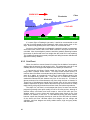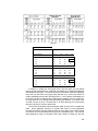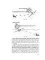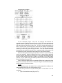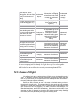
1
CIVIL AIR PATROL
U.S. Air Force Auxiliary
Mission Aircrew
Reference Text
October 2004
This text is designed to provide: 1) the minimum academic knowledge
required by the Civil Air Patrol (CAP) Mission Scanner, Observer and SAR/DR
Pilot task guides and 2) knowledge beyond that required by the aircrew task
guides that will serve as a reference and assist those who wish to learn more
about the various subjects.
Scanning is a systematic method of looking for objects such as downed
aircraft or missing persons. The Mission Scanner’s primary responsibility is to
maintain constant visual contact with the ground while over the search area. This
responsibility makes each scanner a key member of the search aircrew.
The Mission Observer is a scanner with expanded duties who usually sits in
the right front seat. In addition to the primary duty of scanning while in the search
area, the observer assists the pilot with planning, navigation, and communication.
The observer may also server as mission commander, ensuring that all mission
objectives are met.
The Mission SAR/DR Pilot is the aircraft commander and is responsible for
the safety of the crew and the aircraft. The Mission Pilot must fly the aircraft
precisely in order to execute mission procedures and search patterns so that the
scanners have the best possible chance to achieve mission objectives. Naturally,
as Pilot-in-Command the pilot must satisfy all pertinent FAA and CAP regulations
pertaining to certification, currency and the operation of the aircraft; this text
concentrates on mission-specific duties and responsibilities.
The importance of safety is emphasized throughout the text. Lessons learned
in this text will enable aircrew members to operate in a safe and efficient manner,
thus reducing accidents and incidents.
Before beginning training in any of the aircrew ratings you should review and
understand the current CAP 60-series regulations, which provide current
operations and training guidance and requirements. Trainee prerequisites for
each rating are provided in CAPR 60-3 Chapter 2 and SQTR for Mission
Scanner, Mission Observer, and Mission Pilot.
i
Acknowledgements
Many dedicated persons have contributed to the development of the text,
slides, and attachments that make up the CAP Mission Aircrew Reference Text.
Material was taken from CAP sources all over the country. There are too many to
thank, but we will mention several important contributors.
The core of this text was developed from the Southwest Region
Scanner/Observer Course.
Developed, maintained and taught by several
Reserve Officers in the CAP/RAP program that serves Texas Wing and
Southwest Region, the course has been in existence for several years. Lt. Col.
Robert H. Castle, USAFR led this effort.
The text was then modified and expanded to serve as the classroom material
for the National Emergency Services Academy (NESA) Mission Aircrew School,
which was begun in 2000. One of the school co-founders, Lt. Col. Rich Simerson,
developed this text and the associated slides; he now maintains and updates the
materials. The other co-founder, Lt. Col. Mike DuBois, provided invaluable input
and was indispensable in shaping the course. Several instructors and students of
the first two schools also contributed greatly, particularly Major Arden Heffernan,
Major Earl Burress, Captain Galen Hall, and Major Scott Lanis. The NESA
Director, Major John Desmarais, provided unstinting support and assistance.
This text and associated training materials were developed under the
auspices of the National Emergency Services Curriculum Project. Valuable input
was provided by one of the Middle East Region representatives, Lt. Col. Robert
Ayres. This is a 'living' document that is being tested and improved through its
use at the NESA Mission Aircrew School and through field-testing by units
throughout the country as part of the Emergency Services Curriculum Project.
Please direct comments (via e-mail) to the text administrator, Lt. Col. Rich
Simerson, at [email protected]. Please be specific and provide justification for
your comments. If you refer to specific text or figures, please identify them
clearly. If you have better pictures or slides than the ones appearing in the text or
slides, or have others that you feel will improve the text and/or slides, please send
them electronically and include explanatory notes or annotation.
ii
Organization & Guidance
One major requirement is that all students complete the Mission Scanner
course first: the knowledge gained in the scanner course is a prerequisite for both
the Observer and Pilot courses. This is consistent with the fact that Mission
Scanner qualification is a prerequisite on both the MO and MO SQTRs.
This text is augmented by three sets of slides: Scanner, Observer and Pilot.
Using this text and the appropriate slide set(s), any of the three mission
specialties can be taught separately or in any combination.
Each chapter has a list of objectives to assist school directors, project leaders
and instructors. Each objective is tied to one or more of the three mission
specialties (i.e., S = Scanner; O = Observer, and P = Pilot). The associated slides
also reference applicable objectives in the 'Notes' section of the slides.
The table lists the objectives that each mission specialty has in a particular
chapter of the text (if any). Some chapters have objectives for more than one
specialty; the associated slides recognize this and only contain material that
addresses that specialty's objectives (and subsequent depth of knowledge). The
shaded cells indicate that all or the great majority of the chapter is not applicable.
Chapter
Scanner (Objectives)
Observer (Objectives)
1
1, 3 - 5
2
2
ALL
3
ALL
4
1, 3 - 6, 9 - 11
5
ALL
6
8, 9
1 - 7, 10, 11
7
4, 5
1 - 3, 6
8
1, 2, 6 - 9, 11, 12
3 - 5, 10, 13, 14
13, 14
9
1, 5 - 9
2-4
2-4
ALL
ALL
ALL
ALL
10
11
Basic knowledge
2, 7, 8, 12
12
1.d, 2, 8
ALL
13
14
Pilot (Objectives)
1
ALL
ALL
2-5
2-5
To further help both student and instructor, each objective is linked to the text
section that supports it. For example, Objective 4 of Chapter 2 (Aircraft
Familiarization) says to discuss the consequences of exceeding the gross weight
limit. Following the Objective is {S; 2.3.1}, which means that this is a Scanner
objective and the discussion can be found in Section 2.3.1 of the text.
iii
If an objective applies to more than one specialty, this will be identified. For
example, {O & P; 10.3.1} means that both observers and pilots need to know how
the aircraft DF works in both the Alarm and DF modes.
Suppose you want to conduct a Mission Scanner course. From the Table,
above, you know that you will be instructing from Chapters 1 - 9, 11 and 14. You
will also see that the Scanner slides only contain material germane to the Scanner
course.
You may also notice that there is considerable overlap between the Observer
and Pilot objectives from Chapter 8 onward; you may elect to take advantage of
this and combine the two groups at this point (it allows the pilots to help the nonpilots). [Note: because of this overlap, many of the Observer and Pilot slides are
identical.]
Example Classroom Schedules
To further aid course directors and instructors, the following three pages
contain example course schedules. Each table lists the:
•
Subject (chapter number and title)
•
Time (hours and minutes format; minimum required for a knowledgeable
instructor to cover the subject, based on experience from the Mission
Aircrew School)
•
Objectives (chapter)
•
Sections (header numbers of the chapter sections that support the
associated chapter objectives)
•
Slides (that support the associated chapter objectives; from applicable
slide set -- Scanner, Observer or Pilot)
The schedules are constructed as if each course (Scanner, Observer, and
Pilot) will be taught separately. If directors or instructors wish to combine
Observer and Pilot students when covering those subjects applicable to both, the
schedules indicate (with an asterisk) the objectives that are shared by both the
Observer and Pilot.
Although not covered in the text, both the Observer and Pilot course
schedules add time for tabletop exercises to give students practice planning the
various visual search patterns.
[NOTE: Attachment 2, the Flight Guide, is provided separately. Attachment 2 of
this text provides a Table of Contents.]
iv
Scanner Course Classroom Schedule (example)
Subject
Time
Sign-in / Welcome / Overview
CAPR 60-series review slides
Chapter 1
Scanner Duties & CAP Missions
0.30
0.30
0.30
Objectives
1, 3, 4, 5
Chapter 2
Aircraft Familiarization
Chapter 3
Survival & Urgent Care
Chapter 4
Communications
0:55
Sections
Slides
1&2
3
4 - 24
1-9
1.1
1.4 - 1.5
1.7.1
All
25 - 80
0:55
1-3
All
81 - 98
1:35
1, 3 - 5, 8 - 10
99 - 161
Chapter 5
Scanning Techniques & Sighting
Characteristics
Chapter 6
Weather
Chapter 7
High Altitude & Terrain
Considerations
Chapter 8
Navigation & Position Determination
2:00
1-8
4.1.1,
4.1.4 - 4.1.8,
4.2.1 - 4.2.7
All
0:15
8&9
0:15
4&5
1:35
1, 2, 6 - 9, 11
Chapter 9
Search Planning & Coverage
0:30
1, 5 - 9
Chapter 11
Visual Search Patterns
Chapter 14
Crew Resource Management
Scanner Course Review
Scanner Exam
Exam Review
0:30
Basic knowledge
305 - 313
0:30
Basic knowledge
313 - 325
TOTAL
v
0.30
1:00
0:30
12:30
6.4
6.5
7.3
8.1
8.2.3
8.6
8.7.2
8.8
8.9
8.10.1
9.1
9.4.1
9.4.5
9.5
162 - 225
226 - 232
233 - 238
239 - 264
265 - 304
Observer Course Classroom Schedule (example)
Subject
Time
Sign-in / Welcome / Overview *
CAPR 60-series review slides *
Chapter 1
Observer Duties & Responsibilities
Chapter 4
Communications
0.30
0.30
0:30
Objectives
Sections
Slides
2
1.2
1-3
4
5 - 14
0:45
2 *, 7, 8 *, 12
15 - 34
Chapter 6
Weather
2:00
1 - 7, 10, 11
Chapter 7
High Altitude & Terrain
Considerations
Chapter 8
Navigation & Position Determination
0:30
1 - 3, 6
4.1.2 & 4.1.3 *
4.1.7
4.1.8 *
4.3
6.1.3
6.1.5
6.2.1 - 6.2.3
6.3 - 6.4
6.6 - 6.7
7.1 - 7.2
7.4
2:00
3 - 5, 10, 12 *, 13 *
75 - 96
Chapter 9
Search Planning & Coverage
Chapter 10
Electronic Search Patterns
Chapter 11
Visual Search Patterns
Chapter 13
Step Through a Typical Mission
Chapter 14
Crew Resource Management
Flight Planning for a Route search
Flight Planning for a Grid search
Flight Planning for a Creeping Line
search
Flight Planning for a Point-Based
search
Observer Course Review
Observer Exam
Exam Review
TOTAL
0:30
2-4*
8.4
8.5
8.8.1
8.10.1, Attch. 1 *
8.11 *
9.2.1 - 9.2.4 *
97 - 110
1:45
1-7*
All *
111 - 212
1:35
1-6*
All *
213 - 234
2:00
1 - 11 *
All *
235 - 286
0.50
1-5*
14.2 - 14.8 *
287 - 311
0:25
0:25
0:25
Tabletop exercise *
Tabletop exercise *
Tabletop exercise *
0:25
Tabletop exercise *
35 - 58
59 - 74
0:30
1:00
0:30
17:10
* Objective is the same for both Observer and Pilot
vi
Pilot Course Classroom Schedule (example)
Subject
Time
Sign-in / Welcome / Overview *
CAPR 60-series review slides *
Chapter 12
Pilot Duties & Responsibilities
Chapter 4
Communications
0.30
0.30
0:15
Chapter 7
High Altitude & Terrain
Considerations
Chapter 8
Navigation & Position Determination
Chapter 9
Search Planning & Coverage
Chapter 12
Mission Pilot
Chapter 10
Electronic Search Patterns
Chapter 11
Visual Search Patterns
Chapter 13
Step Through a Typical Mission
Chapter 14
Crew Resource Management
Flight Planning for a Route search
Flight Planning for a Grid search
Flight Planning for a Creeping Line
search
Flight Planning for a Point-Based
search
Pilot Course Review
Pilot Exam
Exam Review
TOTAL
Objectives
Sections
Slides
1
12.1
1-3
4
5 - 13
0:30
1.d *, 2 *, 8 *
0:15
Optional (review)
0:50
12 - 13 *
0:30
2-4*
4.1.1 *
4.1.2 - 4.1.3 *
4.1.8 *
7.2.3 *
7.2.4 *
7.4 *
8.9.1 & Attch. 1 *
8.10 *
9.2.1 - 9.2.4 *
47 - 61
2:30
2 - 21
All
62 – 125
1:45
1-7*
All *
126 – 228
1:35
1-6*
All *
229 – 250
1:00
1 - 11 *
All *
251 – 303
0.50
1-5*
14.2 - 14.8 *
304 - 327 **
0:25
0:25
0:25
Tabletop exercise *
Tabletop exercise *
Tabletop exercise *
0:25
Tabletop exercise *
0:30
1:00
0:30
15:05
* Objectives are the same for both Observer and Pilot
** Extra slides (328 - 346) cover Pilot Records and a CAPF 91 Review
vii
14 - 23
24 - 42
43 - 46
References
1.
2.
3.
4.
5.
6.
7.
8.
9.
10.
11.
12.
13.
14.
15.
The following CAP Regulations (CAPR):
a. 60-1, CAP Flight Management, 6/10/04 (includes Change 1, 10/19/04).
b. 60-3, CAP Emergency Services Training and Operational Missions, 5/26/04.
c. 60-5, Critical Incident Stress Management, 8/17/2002.
d. 62-2, Mishap Reporting and Investigation, 11/8/2002.
e. 66-1, CAP Aircraft Maintenance Management, 2/1/2000, with Letters.
f. 100-1 Volume I, Communications, 8/1/1996, with Letters.
g. 173-3, Payment for Civil Air Patrol Support, 5/3/2002.
h. 900-5, CAP Insurance/Benefits Program, 9/1/2003.
CAPP-2, ELT/EPRIB Search, 10/15/91.
Southwest Region Scanner/Observer Course, Version 3.0, 7/4/2000.
Mountain Fury, First Edition, 1999.
United States National Search and Rescue Supplement to the International Aeronautical
and Maritime SAR Manual, May 2000.
EA-AC 00-6A, Aviation Weather.
AC 00-45E, Aviation Weather Services.
FAA-H-8083-3, Airplane Flying Handbook.
Federal Aviation Regulations.
Aeronautical Information Manual.
AOPA/ASA Safety Advisors.
Cessna Pilot Operating Handbooks.
Cessna Pilot Safety and Warning Supplements.
Pocket Guide to USAF Operational Risk Management, John D. Phillips, Air Force Safety
Center.
CAP Operational Mission In-Flight Guide and Aircrew Aid, Scott E. Lanis, MAJ, CAP
viii
Table of Contents
List of Acronyms _______________________________________ xiii
1. Scanner/Observer Duties and CAP Missions ______________ 1
1.1 Mission Scanner duties and responsibilities __________________________ 2
1.2 Mission Observer duties and responsibilities__________________________ 3
1.3 The Observer Log ______________________________________________ 4
1.4 CAP missions _________________________________________________ 5
1.5 Liability_______________________________________________________ 8
1.6 Operational Agreements _________________________________________ 9
1.7 Forms _______________________________________________________ 9
1.8 MIMS _______________________________________________________ 10
2. Aircraft Familiarization________________________________ 11
2.1 Basic aircraft structure__________________________________________ 12
2.2 Aircraft instruments ____________________________________________ 16
2.3 Weight and Balance ___________________________________________ 20
2.4 Preflight inspection ____________________________________________ 23
2.5 Ground Operations and Safety ___________________________________ 25
2.6 Wake turbulence ______________________________________________ 33
3. Survival and Urgent Care______________________________ 39
3.1 Post-crash Actions_____________________________________________ 40
3.2 Survival equipment ____________________________________________ 40
3.3 Urgent care __________________________________________________ 41
4. Communications_____________________________________ 43
4.1 Electronic Communications ______________________________________ 44
4.2 Non-verbal communication ______________________________________ 56
4.3 In-flight services_______________________________________________ 64
5. Scanning Techniques and Sighting Characteristics________ 69
5.1 Scanning ____________________________________________________ 70
5.2 Vision_______________________________________________________ 70
5.3 Fixation Points and Line of Scan __________________________________ 71
5.4 Scanning patterns _____________________________________________ 75
5.5 Atmospheric and lighting conditions _______________________________ 78
5.6 Visual clues __________________________________________________ 81
ix
5.7 Wreckage patterns (accident signs) _______________________________ 83
5.8 Reducing fatigue ______________________________________________ 85
5.9 Directing the Pilot _____________________________________________ 86
6. Weather ____________________________________________ 89
6.1 Basic weather ________________________________________________ 90
6.2 Icing ________________________________________________________ 94
6.3 Frontal activity ________________________________________________ 96
6.4 Reduced Visibility ____________________________________________ 101
6.5 Turbulence__________________________________________________ 103
6.6 Windshear __________________________________________________ 104
6.7 Thunderstorms ______________________________________________ 105
7. High Altitude and Terrain Considerations _______________ 107
7.1 Atmospheric pressure _________________________________________ 108
7.2 Aircraft performance limitations __________________________________ 109
7.3 Effects on crewmember performance _____________________________ 111
7.4 Mountainous terrain___________________________________________ 114
8. Navigation and Position Determination _________________ 115
8.1 Navigation Terms ____________________________________________ 117
8.2 Latitude and longitude _________________________________________ 118
8.3 Magnetic variation ____________________________________________ 120
8.4 Airspace____________________________________________________ 120
8.5 Electronic Aids to Navigation (Navaids) ___________________________ 124
8.6 Sectional Charts _____________________________________________ 133
8.7 Chart Interpretation ___________________________________________ 135
8.8 Chart Preparation ____________________________________________ 139
8.9 Tracking and Recording Position_________________________________ 143
8.10 Standardized Grid Systems____________________________________ 143
8.11 Standardized Lat/Long Grid System _____________________________ 147
9. Search Planning and Coverage________________________ 149
9.1 Search Terms _______________________________________________ 150
9.2 Search Planning _____________________________________________ 151
9.3 Probability of Detection example _________________________________ 158
9.4 Disaster Assessment__________________________________________ 159
9.5 Missing Person Search ________________________________________ 163
x
10. Electronic Search Patterns ___________________________ 165
10.1 ELTs and SARSAT __________________________________________ 166
10.2 Locating the ELT Signal ______________________________________ 167
10.3 Aircraft Direction Finder_______________________________________ 168
10.4 Homing Method _____________________________________________ 172
10.5 Wing shadow method (signal null)_______________________________ 173
10.6 Aural (or hearing) search______________________________________ 176
10.7 Metered search _____________________________________________ 177
10.8 Night and IFR electronic search ________________________________ 178
10.9 Signal Reflection and Interference ______________________________ 179
10.10 Silencing an ELT ___________________________________________ 181
11. Visual Search Patterns_______________________________ 185
11.1 Planning Search Patterns _____________________________________ 186
11.2 Track line (route) search ______________________________________ 187
11.3 Parallel track or parallel sweep _________________________________ 187
11.4 Creeping line search _________________________________________ 190
11.5 Expanding Square search (a Point-Based search) __________________ 193
11.6 Sector search (a Point-Based search)____________________________ 195
11.7 Contour search _____________________________________________ 195
11.8 Other SAR-related GPS Features _______________________________ 197
12. Mission Pilot _______________________________________ 199
12.1 Mission Pilot duties and responsibilities __________________________ 200
12.2 Safety ____________________________________________________ 200
12.3 Types of Flights _____________________________________________ 205
12.4 Security Concerns and Airspace Restrictions ______________________ 211
12.5 Phases of Flight_____________________________________________ 213
12.6 The Mission Pilot and POD ____________________________________ 222
12.7 Flying the Mission ___________________________________________ 223
13. Step Through a Typical Mission _______________________ 227
13.1 Leaving Home for Mission Base ________________________________ 229
13.2 Arrival at Mission Base _______________________________________ 233
13.3 Operational Risk Management Overview _________________________ 234
13.4 General Briefing_____________________________________________ 235
13.5 Aircrew Briefing _____________________________________________ 236
13.6 The Mission Flight Plan / Briefing Form___________________________ 236
xi
13.7 Preparing to Leave on a Sortie _________________________________ 239
13.8 During the Sortie ____________________________________________ 239
13.9 Return From the Sortie _______________________________________ 240
13.10 The Mission Debriefing Form _________________________________ 241
13.11 Aircrew Debriefing __________________________________________ 242
13.12 End of the Mission and the Return Home ________________________ 243
13.13 Conduct Local Drills and Exercises _____________________________ 244
14. Crew Resource Management__________________________ 247
14.1 Statistics __________________________________________________ 248
14.2 Failures and the Error Chain ___________________________________ 249
14.3 Situational Awareness ________________________________________ 249
14.4 Overcoming Loss of SA_______________________________________ 250
14.5 Barriers to Communication ____________________________________ 251
14.6 Task Saturation _____________________________________________ 252
14.7 Identification of Resources ____________________________________ 253
14.8 Assignments and Coordination of Duties__________________________ 253
Attachment 1
Gridding (Appendix E of U.S. SAR Supplement,
chart tables provided separately)
Attachment 2
Flight Guide TOC (Guide provided separately)
Index
xii
List of Acronyms
A/C
Aircraft
A/P
Airport
ADF
Automatic Direction Finder
AFAM
Air Force Assigned Mission
A/FD
Airport/Facility Directory
AFRCC
Air Force Rescue Coordination Center
ARTCC
Air Route Traffic Control Center
AGL
Above Ground Level
AIM
Airman's Information Manual
AM
Amplitude Modulated
ASAP
As Soon As Possible
ASOS
Automated Surface Observing System
ATC
Air Traffic Control
ATD
Actual Time of Departure
ATIS
Automatic Terminal Information Service
AWOS
Automated Weather Observing System
C172/182/206 Cessna aircraft models
CAPF
CAP Form
CAPR
CAP Regulation
CD
Counterdrug
CDI
Course Deviation Indicator
COM/COMM Communication
CONUS
Continental United States (excludes Alaska and Hawaii)
COSPAS
Cosmicheskaya Sistyema Poiska Avariynich Sudov
(Space System for the Search of Vessels in Distress)
CTAF
Common Traffic Advisory Frequency
CRM
Crew Resource Management
DCO
Defense Coordinating Officer
DF
Direction Finder
DME
Distance Measuring Equipment
DoD
Department of Defense
DR
Disaster Relief
DUAT
Direct User Access Terminal
EFAS
Enroute Flight Advisory Service
ELT
Emergency Locator Transmitter
EPIRB
Marine Emergency Position Indicating Radio Beacon
ES
Emergency Services
ETD
Estimated Time of Departure
ETE
Estimated Time Enroute
FAA
Federal Aviation Administration
FAR
Federal Aviation Regulation
xiii
FBO
FCC
FECA
FEMA
FM
FRO
FSS
FTCA
GPS
HIWAS
IAW
IFR
LED
LDG
LFA
MEF
MHz
MIMS
MO
MOA
MOU
MP
MRE
MSCA
MS
MSL
MTR
NESA
NOS
NOTAM
NTSB
NWS
ORM
PA
PIC
PIREP
PLB
RA
RCC
ROA
SA
SAR
SARDA
SARSAT
Fixed Base Operator
Federal Communications Commission
Federal Employee Compensation Act
Federal Emergency Management Agency
Frequency Modulated
Flight Release Officer
Flight Service Station
Federal Tort Claims Act
Global Positioning System
Hazardous In-Flight Weather Advisory Service
In Accordance With
Instrument Flight Rules
Light Emitting Diode
Landing (time)
Lead Federal Agency
Maximum Elevation Figure
Megahertz
Member Information Management System
Mission Observer
Military Operations Area
Memorandum of Understanding
Mission SAR/DR Pilot
Meals Ready to Eat
Military Support to Civil Authorities
Mission Scanner
Mean Sea Level
Military Training Route
National Emergency Services Academy
National Ocean Service
Notice to Airmen
National Transportation Safety Board
National Weather Service
Operational Risk Management
Prohibited Area
Pilot-in-Command
Pilot Weather Report
Personal Locator Beacon
Restricted Area
Rescue Coordination Center
Radio Operator Authorization
Situational Awareness
Search and Rescue
Support State and Regional Disaster Airlift
Search and Rescue Satellite-Aided Tracking
xiv
SCATANA
SQTR
SO
SUA
TPA
TFR
TWEB
USAF
UTC
UHF
VHF
VMC
VOR
VOX
ZULU
xv
Security Control of Air Traffic and Air Navigation Aids
Specialty Qualification Training Record
Safety Officer
Special Use Airspace
Traffic Pattern Altitude
Temporary Flight Restriction
Transcribed Weather Broadcast
United States Air Force
Coordinated Universal Time
Ultra High Frequency
Very High Frequency
Visual Meteorological Conditions
Very High Frequency Omnidirectional Range
Voice Activated
Coordinated Universal Time
Intentionally blank
xvi
Chapter
1. Scanner/Observer Duties and
CAP Missions
1
OBJECTIVES:
1.
2.
3.
4.
5.
State mission scanner duties and responsibilities. {S; 1.1}*
State mission observer duties and responsibilities. {O; 1.2}
Discuss CAP missions. {S; 1.4}
Discuss liability coverage and applicability. {S; 1.5}
List the general rules for entering data into forms. {S; 1.7.1]
* Throughout this text, each objective is followed by:
a. The mission specialty rating to which the objective applies (S =
Scanner; O = Observer; P = Pilot).
b. The section in the text where the answer to the objective may be found.
1
1.1 Mission Scanner duties and responsibilities
The scanner’s primary mission role is effective visual search. “Scanning” is a
method of looking for downed aircraft (or other objects) that makes it possible to
search an assigned area in a systematic way. Scanners are those people trained
in these methods and whose primary responsibility is to maintain constant eye
contact with the ground while flying over the search area. This responsibility
makes the scanner a key member of each aircrew. While the mission observer
has further duties, his or her primary responsibility while in the search area is also
visual search.
The following outlines the duties and responsibilities of scanners for a typical
mission:
•
Report for duty IAW the "IM SAFE" criteria (CAPR 60-1):
Illness - Even a minor illness suffered in day-to-day living can seriously degrade
performance of many piloting tasks vital to safe flight. The safest rule is not to
fly while suffering from any illness. If this rule is considered too stringent for a
particular illness, the pilot should contact an Aviation Medical Examiner for
advice.
Medication - Pilot performance can be seriously degraded by both prescribed and
over-the-counter medications, as well as by the medical conditions for which
they are taken. Federal regulations prohibit pilots from performing crewmember
duties while using any medication that affects the faculties in any way contrary to
safety.
Stress - Stress from everyday living can impair performance, often in very subtle
ways. Stress and fatigue (lack of adequate rest) can be an extremely hazardous
combination.
Alcohol - Extensive research has provided a number of facts about hazards of
alcohol consumption and flying. As little as one ounce of liquor, one bottle of
beer or four ounces of wine can impair flying skills.
Fatigue - Fatigue and lack of adequate sleep continue to be some of
the most treacherous hazards to flight safety, as it may not be
apparent to a pilot until serious errors are made.
Emotion - The emotions of anger, depression, and anxiety may lead
to taking risks that border on self-destruction.
•
Wear appropriate dress for the mission (e.g., gloves, sunglasses, and
uniform appropriate for climate and terrain).
•
Carry and properly use equipment (e.g., charts and maps, headsets,
binoculars, camera, clipboard, and survival equipment).
•
Carry current credentials (e.g., CAP membership card, CAPF 101, and
CAPF 76).
•
Assist in avoiding obstacles during taxiing.
2
•
Obey sterile cockpit rules. These require the crew to limit conversation to
mission- and safety-related topics while in critical phases of flight. They
are typically enforced during taxi, takeoff, departure, approach, and
landing, as well as anytime the crew is executing a high-workload task.
•
Employ effective scanning techniques.
•
Report observations accurately and honestly. Record all sightings to
include the time and geographical location. Include such things as other
aircraft, ground parties, descriptive information concerning your search
area, weather conditions (e.g., sun position, clouds, and search visibility),
old wreckage, and possible sightings.
•
Keep accurate sketches and notes.
•
Properly complete all pertinent paperwork associated with the mission.
•
Report availability for additional assignments.
•
On completion of the day's assignments, return borrowed or assigned
equipment.
1.2 Mission Observer duties and responsibilities
The mission observer has a key role in CAP missions, and has expanded
duties that mainly pertain to assisting the mission pilot. This assistance may be in
the planning phase, handling radio communications, assisting in navigation, and
crew management (i.e., mission commander). The proficient observer makes it
possible for the pilot to perform his duties with a greater degree of accuracy and
safety by assuming these aspects of the workload.
In addition to the scanner duties, observers must also:
3
•
Depending on conditions, you may report with the mission pilot for
briefing.
•
Assist in planning the mission.
commander for the sortie.
•
Assist in avoiding collisions and obstacles during taxiing.
•
Assist in setting up and operating aircraft and CAP radios.
•
Assist in setting up and operating aircraft navigational equipment (e.g.,
VORs and GPS).
•
Assist enforcing the sterile cockpit rules.
•
Maintain situational awareness at all times.
•
Assist in monitoring fuel status.
•
Monitor the electronic search devices aboard the aircraft and advise the
pilot when making course corrections in response to ELT signals.
•
Keep mission base and/or high bird appraised of status.
•
Coordinate scanner assignments and ensure proper breaks for the
scanners (including you). Monitor crew for fatigue and dehydration
(ensure the crew drinks plenty of fluids).
•
Maintain a chronological flight log of all observations of note, including
precise locations, sketches and any other noteworthy information.
The observer may act as mission
•
Depending on conditions, report with the mission pilot for debriefing
immediately upon return to mission base. The applicable portions on the
reverse of CAPF 104 should be completed prior to debrief.
• Keep track of assigned supplies and equipment.
Once team members have been briefed on the mission and accomplished the
necessary planning, observers determine that all necessary equipment is aboard
the airplane. Checklists help ensure that all essential equipment is included, and
vary according to geographic location, climate, and terrain of the search area.
Items on the observer's checklist should include CAP membership and specialty
qualification cards, current charts and maps of the search area, flashlights,
notebook and pencils, binoculars, and survival gear (prohibited items, such as
firearms, should be listed too, to ensure none is included). A camera may be
included to assist in describing the location and condition of the search objective
or survivors. Unnecessary items or personal belongings should be left behind.
The mission observer also assists the pilot in ensuring that all equipment aboard
the search aircraft is properly stowed. An unsecured item can injure the crew or
damage the aircraft in turbulence.
Once airborne, the observer provides navigation and communication
assistance, allowing the pilot to precisely fly the aircraft with a greater degree of
safety. The observer also assists in enforcing "sterile cockpit" rules when
necessary. In flight, particularly the transit phase, the observer maintains
situational awareness in order to help ensure crew safety.
The mission observer divides and assigns scanning responsibilities during her
mission observer briefing, and ensures each scanner performs their assigned duty
during flight. She monitors the duration of scanner activity, and enables the
scanners to rest in order to minimize fatigue.
1.3 The Observer Log
The observer must become proficient in using an in-flight navigational log. A
complete chronological log should be maintained from take-off until landing, and
should include all events and sightings. Skill in maintaining the log requires
training and experience. Remember, proficiency and confidence is gained through
practice and application.
It is important to log the geographical location of the search aircraft at the time
of all events and sightings (as a habit, always log the Hobbs time each time you
make a report or record an event or sighting). This information is the basis of
CAP Form 104, which is passed back to the incident commander and general
staff after the debriefing and becomes a part of the total information that is the
basis for his subsequent actions and reports. Good logs give the staff a better
picture of how the mission is progressing.
If sketches or maps are made to compliment a sighting, note this and attach
them to the log. The log and all maps and sketches will be attached to the CAPF
104.
A sample Observer Log (and instructions) is included in Attachment 2, Flight
Guide.
4
1.4 CAP missions
As a review, the Civil Air Patrol (CAP) has three equally important missions:
Aerospace Education, the Cadet Program, and Emergency Services. The
Mission Aircrew course involves all aspects of the Emergency Services mission,
including search and rescue (SAR), disaster relief (DR), life support, civil defense,
and emergency communications.
As the civilian noncombatant auxiliary of the United States Air Force (USAF)
and a private nonprofit corporation, the CAP was established under Federal law
by Congress (36 U.S.C. 201-208 1101). The CAP is tasked with a wartime
mission, peacetime disaster relief mission, a SAR mission, a counter-drug (CD)
mission, support of the American Red Cross, and U.S. Customs support. A
Memorandum of Understanding (MOU) between the USAF and CAP was
instituted on 25 Jan 91 that defines the current duties and responsibilities of the
CAP.
CAPR 60-1 prescribes the responsibilities of CAP personnel as applicable to
the control and management of CAP flying programs, aircraft, and aircrew. CAPR
60-3 prescribes concepts, policies and standards that govern all CAP supervisory,
ground, and flight personnel in the training, qualification and execution of CAP
operational missions. Task guides and reference texts contain CAP ES forms.
Supplements or operating instructions (OI) to these regulations may exist, but
they may only be issued by Wings and then only with prior written approval of
National Headquarters/DO.
1.4.1 The Wartime Mission
CAP OPLAN 1000 provides for CAP support to the National Command
Authorities (NCA) in a declared national emergency operation — in other words,
war. The CAP would supplement the military defense with a civil defense for the
protection of life and property in the event of an attack on the U.S. Specifically,
the CAP would:
•
Provide a communications network (fixed, mobile, and airborne).
•
Provide assessment of damage to highways and facilities.
•
Support State and Regional Disaster Airlift (SARDA).
• Provide radiological monitoring and decontamination teams.
Command and control during these operations remains within the CAP chain
of command at all times. Although operational control of a particular mission may
rest with another agency, CAP directives apply to CAP resources.
A national emergency may also invoke the Security Control of Air Traffic and
Air Navigation Aids (SCATANA) plan. The purpose of this plan is to provide
security control of civil and military air traffic, navigational aids, and airspace use.
It may involve the use of military interceptors, directed dispersal, landing, or
grounding of aircraft, shutdown of navigational aids, or IFR-only operations.
Mission records are to be kept for seven years and reimbursement for fuel,
oil, and maintenance is IAW CAPR 173-3, Payment for Civil Air Patrol Support.
1.4.2 Peacetime Disaster Relief
Information concerning the CAP peacetime disaster relief mission is
contained in CAPR 60-3. During a peacetime disaster, CAP resources are tasked
5
for assistance as a component of the Federal Emergency Management Agency
(FEMA) Urban Search and Rescue Program, or under USAF auspices for military
assistance to civil authorities. These operations could involve assistance during
flood, forest fires, toxic spills, earthquakes, storms, etc. It does not include
unlawful civil violence or enemy attack.
Command and control of CAP resources always remains with CAP. If the
CAP is the lead agency, the CAP incident commander may be assigned as the
overall incident commander.
CAP assistance to law enforcement agencies is restricted to patrol,
reconnaissance, and reporting only. CAP members may not be deputized,
actively arrest or detain individuals, nor do they have any authority to restrict
persons by means of force, actual or implicit. The senior CAP member on duty
will ensure these restrictions are understood by both the CAP member and law
enforcement agencies.
A Natural Disaster Employment Report is called a Tempest Rapid I or III
(final). The IC sends it to the CAP-USAF liaison officer. Mission records are to be
kept for 7 years and reimbursement for fuel, oil, maintenance, and
communications is IAW CAPR 173-3.
1.4.3 Search and Rescue (SAR)
Information concerning the CAP search and rescue mission is contained in
CAPR 60-3. The USAF is the SAR coordinator for the Inland Region of the
Continental United States (CONUS). The Coast Guard controls the Maritime
Region and the Overseas Unified Command controls the Overseas Region.
Within the CONUS, the Air Force Rescue Coordination Center (AFRCC) of
the USAF carries out the National Search and Rescue Plan. As an auxiliary of the
USAF, CAP provides the primary resources (4 out of 5 searches) for SAR. CAPR
60-3 sets out specific guidance for air and ground operations, including activation
procedures, command and control, mission management, air and ground
operations, and mission suspension or closure.
Records are to be kept for seven years and reimbursement is IAW CAPR
173-3.
1.4.4 Counterdrug operations (CD)
Information concerning the CAP counterdrug mission is contained in the
CAPR 60-6 and the Counterdrug Handbook. The CAP, with the concurrence of
the USAF, has established national agreements with the U.S. Customs Service,
the Drug Enforcement Administration and the U.S. Forest Service to participate in
a program of air reconnaissance to assist in locating illicit drug traffic and growing
activities. The CAP role is limited to data gathering and supporting base
communications. Actual CAP emergency services missions have priority over CD
operations for the use of CAP resources.
No CAP region, wing, or other unit may supplement, amend, restrict or
change these agreement guidelines or procedures. CAP members may not
participate in arrest, seizure, or detention operations. Command and control
remains within the CAP chain of command. Mission execution is IAW CAP 60series regulations. Missions are debriefed to the applicable CAP CD officer.
6
1.4.5 Homeland Security
TBD.
CAP is now coordinates with USAF Homeland SEcurity(AF/XOS-HA).
CAP National HQ has established the Counter Drug / Homeland Security
department under the Operations directorate, and a National Operations Center
that is manned 24 hours a day (1-888-211-1812).
The CAP assists the President and/or Secretary of Defense during national
security emergency preparedness (NSEP) operations. NSEP operations are those
that take place either during or immediately preceding a major disaster, national
emergency or national security emergency, as defined by the President.
CAP participates in Military Support to Civil Authorities (MSCA), as well as
providing direct support of the Air Force and Department of Defense (DoD)
components during national security emergencies.
CAP personnel and equipment may be requested to support the Secretary of
Defense, DoD combatant commands, and other DoD, federal, state and local
agencies. Depending on the size of the disaster or contingency to be supported,
CAP forces may range from elements of a single squadron to multiple wings
across the country. If CAP assistance is requested by the Lead Federal Agency
(LFA) and/or the Defense Coordinating Officer (DCO), those units closest to the
scene will be the first to be called upon.
1.4.6 National Agencies
The CAP has Memorandums of Understanding (MOUs) with national
agencies such as the DEA, Customs, U.S. Forest Service, FEMA, Red Cross,
Salvation Army, Department of the Interior, Federal Aviation Administration,
Federal Highway Administration, NASA, National Communication Systems,
National Weather Service, National Transportation Safety Board, and the U.S.
Coast Guard Auxiliary. CAP Wings may have MOUs with state agencies such as
the Department/Division of Emergency Management, Department of Public
Services, State Forest Service, and State Park Service.
Air Force assigned mission status may be extended to national, state, and
local MOU missions. The basic USAF/CAP MOU provides that Air Force nonreimbursed assigned mission status will apply to “support missions requested by a
state/local government or private agencies which are specified in memoranda of
understanding or letters of agreement that have been signed and approved by
appropriate Air Force authority.”
Air Force mission numbers will not be issued for CAP missions in support of
other federal, state, local or private agencies unless there is a MOU or letter of
agreement with that agency or organization. Each MOU addresses the issues of
third party liability coverage, Workmen’s Compensation benefits, and expense
reimbursement, and specifies if the Air Force or the supported agency/activity will
provide the coverage.
All of the MOUs make it clear that support is given on an “as available” basis,
and that U.S. Air Force missions have top priority.
CAP’s MOUs can be found on the national web site (http://level2.cap.gov)
under “General Counsel.”
7
1.5 Liability
CAP, along with the Air Force, provides liability coverage for the organization
and members. The Air Force coverage applies when CAP is engaged in missions
certified by CAP-USAF as an Air Force Assigned Mission (AFAM); CAP coverage
applies when CAP is engaged in corporate activities or missions. The following is
taken from CAPR 900-5, The CAP Insurance/Benefits Program.
Federal Employee Compensation Act (FECA) coverage is provided for all
AFAMs as defined in CAPR 60-1 and the USAF/CAP MOU. This is the
Workmen's Compensation Program for federal workers. The coverage provides
full medical benefits, plus death, burial and disability benefits.
State and local missions are not covered by FECA; these missions are
designated as CAP “Corporate (C)” missions IAW CAPR 60-1 and are covered by
commercial insurance; if an injury or death occurs, this insurance provides a
$10,000 death benefit and up to $6,000 medical expenses. Coverage is provided
so long as proper CAP authority authorizes the mission and the PIC is licensed
and certificated as required by Federal Aviation Regulations. This liability
coverage also applies to member owned/furnished aircraft.
The Federal Tort Claims Act (FTCA) offers liability protection on AFAMs. CAP
members are covered by "Good Samaritan" laws, but should only attempt the
most basic urgent care procedures (unless specifically trained otherwise). There
is no FTCA coverage on corporate missions; if a non-member’s property is
damaged or a non-member is injured, CAP’s liability insurance will cover CAP and
the member in the event of a lawsuit against CAP or the member.
A CAPF 78, Mishap Report Form, must be submitted promptly in all cases
involving reportable CAP mishaps (see CAPR 62-2, Mishap Reporting and
Investigation). All CAP aircraft and vehicles must have a copy the latest CAPF 78
(sent by the respective wing) in the aircraft/vehicle at all times; this form contains
the relevant telephone numbers you will need in the event of a mishap.
It is vitally important that CAP members follow all rules and regulations during
missions. This includes wearing the proper uniform and carrying the proper
credentials, and filing a CAPF 78 when necessary. Not following the rules may
make you ineligible for coverage under FECA, FTCA, and corporate insurance,
and can result in a member being held personally responsible for the damages or
medical expenses incurred as a result of a mishap.
Wing and Region Commanders may assess CAP members for the cost of
repairs due to damage of CAP aircraft (see CAPR 60-1).
Another important item for insurance coverage involves protecting the
aircraft's avionics and instruments. It is mandatory that the crew properly secures
the avionics lock and locks the doors anytime the aircraft is left unattended.
8
1.6 Operational Agreements
To facilitate mission execution, once tasking is received by the CAP
prearranged agreements are already in place to cover most contingencies. These
exist at the national, regional and state/local levels so that we do not reinvent the
wheel for each new tasking. These agreements are formalized through the
respective agencies’ chains of command and signed off at all levels so that
everyone understands their responsibilities and actual level of involvement for
each contingency.
1.7 Forms
OPLANs, MOUs, regulations and agreements do not get the work done—
people do. To ensure standardized training and mission accomplishment, a
series of forms facilitate scanner and observer upgrade and mission execution.
Some of these forms are the CAPF 76 (ROA), CAPF 101, Aircrew SQTRs, the
CAPF 104, FAA Flight Plan 7233-1, and CAPF 108.
CAPF 76 is a Radio Operator Authorization (ROA). Requirements are set
forth in CAPR 100-1 Volume I, Communications.
CAPF 101, the Specialty Qualification Card, is used to identify missionqualified personnel. Wing ES staff complete this form. Each member is required
to have a valid 101 card to participate in missions.
Aircrew Specialty Qualification Training Records (SQTR), are available in
MIMS or can be issued by the unit commander to define and document training
toward qualification in an ES specialty. Scanners use the MS SQTR, Observers
the MO SQTR, and SAR/DR Pilots the MP SQTR.
CAPF 104 is the Mission Flight Plan/Briefing Form; the pilot usually fills out
this form with the observer's assistance. The mission usually begins with a
general briefing, followed by an individual sortie briefing. The briefing section of
the CAPF 104 is used to ensure that critical aspects of the upcoming mission are
covered. An accurate mission log, kept by the observer during the flight, allows
the mission debriefing section (the back of the CAPF 104) to be filled out.
The CAP Flight Plan is also contained on the front of the CAPF 104, primarily
on the right-hand side. It is prepared and filed by the mission pilot and must be
closed out with the Flight Release Officer after landing. For cross-country flights
greater than 50 nm, a FAA Flight Plan must be filed if a CAPF 104 or 84 are not
used. Both show the intended route of flight, details about aircraft markings and
performance, anticipated flight time, available fuel, and souls on board to facilitate
rescue efforts in case of an emergency.
The FAA Flight Plan and CAPF 104 are covered in Chapter 13.
The CAPF 108 is used to claim reimbursement for CAP missions IAW CAPR
173-3.
Generally, fuel, oil, limited maintenance, and mission-essential
communications expenses are covered by the tasking agency.
1.7.1 Entering Data into Forms
The most basic rule for filling out forms is to enter data accurately and legibly.
Remember that the customer can't read your mind and shouldn't have to resort to
9
an ouija board to decipher your handwriting. So, if your handwriting is poor, print;
if your printing is poor, have another crewmember fill out the form.
CAP forms are available in electronic format (link from the CAP national
website: www.capnhq.gov), and many are capable of performing necessary
calculations and the like as you enter data. Presently only certain CD forms are
required to be computer or typewriter generated, but CAP will eventually require
most forms be filled out in this manner. [If feasible, make templates of the forms
you use the most: filling in data that doesn't change (e.g., local and aircraft
information) and then using the SAVE AS feature each time you use the form will
save you lots of time.]
Some general rules to follow are:
•
Avoid the use of "Liquid Paper" when making corrections to any forms.
•
To correct mistakes draw a single line through the error and initial.
•
Do not use signature labels or stamped signatures.
•
Do not submit CAPF 108s that have things copied onto them, such as
receipts or notes.
•
Attach copies of all receipts that support expenses claimed on the CAPF
108.
•
Attachments (e.g., expense receipts or maps) should have your name,
the date, aircraft 'N' number, mission and sortie numbers, and Hobbs time
on them so they can be tied to the CAP form if they become separated.
•
Always have another crewmember review the form before submittal. If
there are any blanks or 'N/A' entries, make sure that is what you intended.
1.8 MIMS
New members must go to http://www.capnhq.gov and sign up for CAP
eServices. Once you have your password, bookmark the page and then spend
some time familiarizing yourself with the available features, particularly the “CAP
Utilities” on the left side of the page. You should also review the “MIMS Tutorials”
Training requirements for emergency services specialty qualifications are
transitioning from the old CAPF 101Ts to those found in the appropriate Task
Guides for ES specialties. Task Guides are now available electronically for all
specialties with other curriculum (including this Reference Test and the Flight
Guide) at http://level2.cap.gov/index.cfm?nodeID=5312 and will soon be available
for purchase from CAPMart (www.capmart.org).
As you go through your emergency services qualifications, enter task
completions into the applicable 101T (SQTR). When you have completed a
qualification, you can then print your new CAPF 101(e).
10
Chapter
2. Aircraft Familiarization
OBJECTIVES:
1.
2.
3.
4.
5.
6.
7.
8.
11
State the basic function of the following aircraft components:
{S; 2.1.1 - 2.1.5}
a.
Ailerons
b.
Elevator
c.
Rudder
d.
Trim tabs
e.
Fuel selector
Discuss the relationship between the magnetic compass and heading
indicator. {S; 2.2.1 & 2.2.2}
State the basic function of the altimeter, airspeed indicator, attitude
indicator, GPS, nav/comm radios, audio panel, and transponder.
{S; 2.2.3 - 2.2.11}
Discuss the consequences of exceeding the gross weight limit.
{S; 2.3.1}
Discuss the importance of maintaining proper balance (c.g.), and
factors in computing weight and balance. {S; 2.3.2 & 2.3.3}
State the purpose of the preflight inspection, and discuss the items
checked during the preflight inspection. {S; 2.4}
Discuss ground operations and safety, including: {S; 2.5}
a.
Ramp safety
b.
Moving and loading an aircraft
c.
Entry and egress
d.
Fuel management
e.
Taxiing, including airport signs and markings
f.
Flightline hand signals {Figure 2-9}
Discuss wake turbulence, including where it is most likely to be
encountered. {S; 2.6}
2
2.1 Basic aircraft structure
An understanding of the basic elements that make up the structure of most
general aviation aircraft will help you understand how the aircraft is controlled.
When executing search patterns, the aircrew should know the aerodynamic parts
that cause the aircraft to turn, climb, and roll.
The basic structure of a conventional airplane is the fuselage, and all other
parts are attached to it. This is true for most single-engine aircraft. The primary
source of lift is the wing while other parts provide stability and control. The tail, or
empennage, consists of the horizontal stabilizer with its attached elevators and
the vertical stabilizer with its attached rudder.
The basic aircraft control surfaces can be seen in Figure 2-1, along with a
general aircraft design. The effects of aileron, elevator, and rudder movements
can be seen in Figures 2-2 through 2-4.
Vertical stabilizer
Empennage
Rudder
Right aileron
Right wing
Elevator
Landing flap
Horizontal stabilizer
Left aileron
Fuselage
Left wing
Figure 2-1
12
Right aileron
UP
Left aileron
DOWN
Longitudinal axis
Figure 2-2
Horizontal axis
Center of gravity
Center of gravity
Figure 2-3
13
Center of
gravity
Push right
rudder pedal
Push left
rudder pedal
Figure 2-4
2.1.1 Ailerons
Ailerons are movable surfaces attached to the trailing edge of the wing,
toward the wing tip from the flaps. They control roll or movement around the
longitudinal axis. When the aileron on one wing goes down, the aileron on the
other wing automatically goes up. If the pilot wants to roll to the right, he turns the
yoke to the right, and the right aileron goes up. This will create a loss of lift on the
right wing and result in a roll to the right. At the same time the left aileron goes
down and increases lift on the left side, assisting in the roll action to the right.
2.1.2 Elevator
An elevator is a control airfoil attached to the trailing edge of the tail's
horizontal stabilizer. It controls pitch, or movement of the nose up or down.
When the stick, or wheel, is moved back, the elevators are raised. The raised
elevators and actions of relative winds cause a down force on the tail and raise
the nose. The relative wind causes an opposite action when the pilot pushes the
yoke forward.
2.1.3 Rudder
The rudder is an airfoil attached at the trailing edge of the tail's vertical fin. It
is designed to control the yawing, or side-to-side action around the vertical axis of
the aircraft. The action is controlled through right and left pedals at the pilot's feet.
If she pushes the left pedal the rudder swings to the left, creating a force that
pushes the tail to the right. The nose of the aircraft then moves, or yaws, to the
left.
2.1.4 Trim tabs
A trim tab is used for fine control. It is an auxiliary surface attached to trailing
edges of airfoils. When a continuous but slight pressure on the controls is
required for straight and level flight, the pilot might adjust a trim tab to get the
14
proper balance and be free from exercising continuous control on a long, tiring
flight. Small knobs, or wheels, in the cockpit are provided to affect some of these
adjustments in flight. Other tabs are adjustable only when the aircraft is on the
ground. If the pilot lands and reports tail, nose, or wing heaviness, the remedy
might be an adjustment of the tabs according to the need. Trim tabs are
sometimes combined with balancing tabs and flying tabs.
Rudder trim
tab
Elevator trim
tab
Aileron trim
tab
This brief look at the basic structure of an airplane does not explain all there is
to know about the control surfaces. With this familiarization you should be able to
recognize these parts and understand in a general way how they function.
2.1.5 Fuel Selector
Although not part of the aircraft structure, the fuel selector is very important.
The POH checklist details when the switch must be in BOTH (e.g., for takeoff and
landing) but the PIC will often position the switch to RIGHT or LEFT to even out
fuel consumption. The switch is also placed in RIGHT or LEFT prior to refueling.
If you move this switch during flight, log it.
15
2.2 Aircraft instruments
2.2.1 Magnetic compass
The magnetic compass shows the aircraft’s heading in relationship to the
earth’s magnetic North Pole. This instrument requires no power or vacuum,
so it can be used even in the event of complete electrical or vacuum system
failure. However, it is not as stable as gyro-driven heading indicators, and
does not show heading well during turns. It also is affected by the metal
structure of the aircraft and by the magnetic fields produced by electronic
equipment. It is primarily used to calibrate the other heading systems and as
a backup in case they fail.
2.2.2 Heading Indicator
The heading indicator is easier to use than the magnetic
compass. Because it is gyroscope-driven it provides a
steady, reliable indication during turns. Since gyroscopes
can develop errors over time, this instrument must be aligned
periodically during a flight. It may be automatically updated
through a “slave” connection to a magnetic compass, or the
pilot may manually set it. The gyroscope that powers this
instrument is normally driven by a vacuum pump but may be
electrically powered.
2.2.3 Altimeter
The altimeter shows pressure altitude, and is usually set to show altitude
above Mean Sea Level (MSL). If the local barometric pressure is not set in the
instrument, the altitude reading will not be correct.
2.2.4 Turn Coordinator
The turn coordinator combines two instruments. The miniature aircraft
indicates the direction and rate at which the aircraft is turning. The ball on the
bottom is a slip indicator that indicates whether the aircraft is flying straight or is
yawed to one side or another.
16
2.2.5 Airspeed indicator
The airspeed indicator shows the speed at which the aircraft is moving
through the air. It is normally calibrated in nautical miles per hour (knots),
although some indicate statute miles per hour. There are colored arcs around the
outside of the dial indicating certain operating limits for the aircraft. These may
include flap operating range, normal operating range, and maximum speed. Refer
to the aircraft’s operating manual for a complete description of the colored arcs
and their meaning.
2.2.6 Vertical speed indicator
The vertical speed indicator indicates the rate at which the aircraft is climbing
or descending. It is usually calibrated in feet-per-minute. This instrument is most
often used while flying in instrument conditions. Because of its design, it has a
one or two second lag before an accurate indication is displayed.
2.2.6A Attitude Indicator
The attitude indicator is highly reliable and the most realistic flight instrument
on the panel. Its indications are very close approximations of the actual
attitude of the airplane. It is normally powered by the vacuum system.
17
2.2.7 Engine instruments
Each aircraft has a different set of engine instruments. These may include a
tachometer to show engine speed (rpm), oil pressure gauge, oil temperature
gauge, and cylinder head temperature. Many engine instruments have colored
arcs to show normal operating ranges.
2.2.8 Global Positioning System (GPS)
The GPS is a satellite-based system that provides highly accurate position
and velocity information. GPS is unaffected by weather and provides a common
grid reference based on latitude and longitude. GPS receivers (ARNAV Star 5000
and Apollo GX55 shown below) measure the distance from the satellites (usually
the best four) using the travel time of radio signals. The receiver computes
navigational values such as distance and bearing to a point, ground track and
speed, and estimated time-in-route by using the airplane's known position and
referencing this to its database. This database also contains much other useful
information concerning airports and navigational aids.
A typical VFR-rated GPS will provide horizontal position accurate to within 30
meters and vertical position accurate to within 160 meters.
18
2.2.9 Navigation/Communications Radios
Most civil aircraft use VHF (AM) for short-range communications; military
aircraft use UHF (AM) or VHF. Most CAP aircraft are equipped with dual
navigation/communications transceivers (Nav/Comm). These allow the pilot to
talk to ground agencies, other aircraft and navigate the aircraft. The figure below
shows a typical nav/comm radio (KX 155); the one in your aircraft may be slightly
different. The communication side allows the pilot to tune in a voice frequency
and have another in "standby" mode. The navigation side works the same way,
allowing the pilot to tune the specific frequency for an electronic navigation aid.
Either frequency can easily be transferred into the active window by the push of a
button (this function is often referred to as "flip-flop").
2.2.10 Audio Panel
The audio panel (KMA 24 and PMA7000MS shown below) serves two primary
functions: it selects which radio(s) the crew will be transmitting on and listening to,
and allows various communication and navigation instruments to be directed to
the aircraft's overhead speaker or to the headphones. Because improper setup of
the audio panel can lead to confusion and missed radio calls, do not reposition the
switch or any of the pushbuttons without consulting with the Pilot-in-Command!
Operation of the audio panel is covered in detail in Chapter 4.
19
2.2.11 Transponder
The Mode C altitude-reporting transponder provides a strong signal to ground
radar and provides air traffic controllers with information such as airplane
identification, position and altitude.
The transponder is usually warmed up in the Standby position while taxiing; it
is turned on (ALT) just before you take the active runway. CAP aircraft
transponders must be on during flight.
Knobs allow you to select the desired (or assigned) code on the transponder.
The normal code for VFR flight is 1200, although ATC will assign a different code
when you are in a terminal radar service area or have requested flight following.
Also, ATC may request that you "Ident"; pressing this switch (or button) will send
a pulse that causes a special symbol to appear on the radar screen to allow
positive identification by the controller.
There are some codes used only for special situations or emergencies, and
you should avoid passing through these codes when you are setting or changing
your assigned code. These codes are 7500 (for hijacking), 7600 (for lost
communications), and 7700 (for emergency).
2.3 Weight and Balance
You will often hear the phrase “weight and balance” used in conjunction with
preflight planning and preparation of the aircraft. Aircraft are designed to operate
within specific design criteria, and exceeding these criteria can have devastating
consequences. This section will discuss these issues in general terms. For
information relating to weight and balance for a specific make and model of
airplane, you should refer to the aircraft’s flight manual.
2.3.1 Weight
The force of gravity continually attempts to pull the aircraft toward the ground.
The only force that counteracts weight is the lift generated by the wings.
However, the amount of lift produced by an airfoil is limited by the airfoil design,
angle of attack, airspeed, and air density. Therefore, you must avoid overloading
the aircraft to ensure sufficient lift is generated to counteract the weight. If aircraft
20
weight exceeds the manufacturer’s recommendations, the aircraft may not be able
to take off, or may exhibit unexpected and potentially lethal flight characteristics.
Every item on the aircraft contributes to its weight. Each aircraft is weighed
after production and the figures are recorded in the maintenance log. When extra
equipment, such as radios or other instruments, is added to the aircraft, the
aircraft’s weight is adjusted in the log. This figure is commonly referred to as
“empty weight.” For each flight, the pilot computes further increases in the weight
for items that are required for that flight. The first of these is oil and fuel for the
engine. Fuel weighs approximately 6 pounds per gallon, so this is a very
important consideration. If a large load is carried in the aircraft, the pilot may elect
to only partially fill the fuel tanks. This, of course, limits range and must be done
very carefully because the fuel gauges are not accurate enough to indicate small
quantities of fuel.
2.3.2 Balance
Balance refers to the location of the center of gravity (c.g.) of an airplane and
is critical to airplane stability and safety of flight. While gravity obviously affects
the entire aircraft, for computations it can be assumed that the aircraft’s weight is
concentrated at the center of gravity. Figure 2-5 shows that gravity pulls down on
the center of gravity, and the wings produce lift to counteract that force. The
horizontal tail surface produces lift in a downward direction to balance weight and
lift and keep the aircraft level. The pilot can change the force created by the
horizontal tail by deflecting the elevator, and that causes the nose of the aircraft to
go up and down. The purpose of planning aircraft balance before flight is to
ensure the horizontal tail can generate enough lift to balance the aircraft and
provide sufficient pitch control. The pilot controls the balance of the aircraft by
calculating the center of gravity and loading the airplane to keep the c.g. within
certain limits.
Lift
Weight
Force from horizontal
tail surface
Figure 2-5
If the c.g. is not adjusted properly before flight, it can affect the stability of the
aircraft. Modern civilian aircraft are designed to be stable in flight; this makes the
aircraft safer and easier to operate. Positive pitch stability causes the aircraft to
stay in a stable pitch attitude without constant manipulation of the controls, and
pitch stability depends on the location of the c.g. in relationship to the center of lift.
If the aircraft is loaded “tail heavy,” the center of gravity will move aft toward the
21
center of lift, and the aircraft will become less stable. In worse case conditions
this can make stall recovery difficult or impossible.
Incorrect balance can also affect the control of the aircraft. The elevator on
the horizontal stabilizer is used to vary the force on the tail and thereby change
the pitch attitude of the aircraft. If the aircraft is loaded “nose heavy,” it could
result in a condition where the horizontal tail surface cannot generate enough
force to raise the nose. This is especially noticeable at the slow airspeeds that
are used during takeoff and landing, and that is the worse possible time to
discover you have a balance problem.
The manufacturer establishes limits for the location of the airplane's center of
gravity. There are fore and aft limits beyond which the c.g. should not be located
for flight. For some airplanes, the c.g. limits, both fore and aft, may be specified to
vary as gross weight changes. They may also be changed for certain operations
such as acrobatic flight.
Every item in a balance problem has two components, a weight and a
moment arm. Even the empty aircraft has both of these components. The
moment arm is the item’s distance from a specified point on the aircraft called the
datum. In civilian aircraft the datum is often located at the aircraft’s firewall, but
that is not always the case. Figure 2-6 shows the parts of a typical balance
problem. The pilot begins with the weight and moment arm of the empty airplane,
and then makes changes for the oil, fuel, passengers and baggage. The result
must fall within the published limits for the aircraft, or something will have to be
moved until the c.g. falls within those limits.
Datum
Pilot
Oil
Fuel
Empty
Airplane
Baggage
Figure 2-6
2.3.3 Computing weight and balance
Computing weight is very simple. The pilot starts with the documented empty
weight of the aircraft and adds the weight of any items that are loaded for the
flight. This figure should not exceed the published maximum gross weight for the
aircraft.
Computing balance is a little more involved. Each item’s weight and moment
arm must be used to determine whether the loaded aircraft falls within the
manufacturer’s limits. Here’s an example problem:
22
Item
Weight
Empty airplane
Oil
Pilot and front
passenger
Fuel
Rear seat passenger
Baggage
Totals
Moment /
1,000
1340
15
320
51.6
-0.3
11.2
240
300
60
2,275
11.6
21.6
5.5
101.2
The moment for each item is determined using another chart in the aircraft
manual. Then, the total weight and moment are used to enter the chart shown
below and determine whether the aircraft is properly loaded. In this case, the
aircraft falls within the c.g. envelope for normal operations.
2400
2300
Normal
Category
2200
Loaded
Aircraft
Weight
(LBS)
2100
2000
Utility
Category
1900
1800
1700
1600
1500
50
55
60
65
70
75
80
85
90
50
100 105 110 115
Loaded Aircraft Moment/1000 (LB INS)
Notice the moment arm for the oil is a negative value. This happens because the
datum for this aircraft is located at the firewall, and the oil is located in the engine,
which is in front of the firewall. The moment for the oil is subtracted from the total
moment, and all other calculations proceed as normal.
2.4 Preflight inspection
The act of preflighting an airplane is no more than a safety check and
evaluation of the craft's condition for the flight. This is the pilot's responsibility, and
exactly how it is done will depend on the pilot's individual routine. Normally, the
rest of the aircrew stands well clear as this preflighting process is carried out. If
23
you are asked to help, you probably will call out each item on the checklist. When
the pilot has examined the item called out, he or she will give a signal such as
"check" or "OK." This means the pilot is ready for the next item to be called out.
This method of checklist accomplishment is called “challenge and response.”
Figure 2-7 shows the major parts of the aircraft that are included in the preflight
inspection.
Right
Aileron
Vertical
Stabilizer
Empennage
Right
Flap
Rudder
Trim Tabs
Right
Wing
Elevator
Left Flap
Left
Aileron
Propeller
Nose
Gear
Main
Gear
Landing
Light
Left Wing
Figure 2-7
The walk-around inspection is the major portion of preflighting (remember that
looking for potential obstructions in the parking area is part of the preflight). A
visual inspection will be made to ensure the aircraft is airworthy. Condensation
can accumulate in the fuel tanks, and water in the aircraft’s fuel can result in a
reduction or complete loss of power. Aircraft fuel tanks have a drain at the
bottom, and the pilot will use a "fuel sampler" to extract a small amount of fuel
from each tank and inspect it for water contamination. Note: for environmental
reasons, fuel that is 'sumped' in this manner should be placed in a designated
container rather than being thrown out on the ramp.
Fuel gauges sometimes malfunction, so a visual check of the fuel quantity is
accomplished. On high wing aircraft the pilot may have to use a stepladder to get
to the fuel filler caps. Remove each cap and peer in the tank to make certain that
it is filled. Normal procedure is to fill the tanks upon completion of each sortie, but
larger aircraft may not fuel "to the top" after each flight: in this case, each aircraft
should have a measuring device to accurately determine fuel levels. As the walkaround continues, every movable, attached part will be tested for freedom of
movement. Also hinges will be scrutinized closely to see that they are fully in
place and not worn thin.
The propeller and its attachment to the engine receive careful attention. A
large nick or hairline crack in a propeller could cause it to fail in flight. There are
many other items to check as the pilot continues the walk-around inspection.
When it is completed you will be instructed to board the airplane. Remember to
fasten your seat belts securely.
24
More preflighting will take place after the crew is in the airplane. Other
checklists are followed to start the engine, adjust radios and electronic navigation
equipment, and check control surfaces. This is the before-takeoff checklist that
must be completed upon reaching the runway. It is a short one and is used to see
that the engine is working properly, the controls are free, and that the control
surfaces (ailerons, elevator, and rudder) are moving in the right directions. In
addition to what is on the checklist, every pilot will take a last-minute look at
certain items before the actual takeoff is started.
2.5 Ground Operations and Safety
Safety begins when you arrive at the airport. We will discuss operations and
safety practices that apply from the time you arrive until takeoff.
NOTE: The most dangerous part of any mission is driving to and from the
airport or mission base. Even though you should treat every callout as an
emergency, you should always obey traffic signs and speed limits. An accident,
even a minor fender bender, will delay you far longer than if you had stopped at all
traffic lights and stayed within posted speed limits.
2.5.1 Ramp safety
Safe activity in the vicinity of aircraft depends on everyone knowing certain
“do's and “don'ts.” Memorizing a list of what one should and should not do is
desirable, but everything that could happen in a situation cannot be contained in a
list. So, knowing certain basics are a beginning only; from this point on the
person must be observant and think! Distraction and hurrying are part of a sure
formula for mistakes.
In addition to remembering some very important do's and don'ts, and thinking,
it is good practice to demonstrate courtesy. The Civil Air Patrol and individual
aircraft owners who lend their craft to missions have a lot of money invested.
Remember, aircraft and the equipment on them are fragile. Because of high
investment and the fragility of the craft, owners are very protective of their
property. Your demonstration of respect for their property will cause them to
accept you quickly as one of the team.
No smoking
You will see "No smoking within 50 feet" signs at aviation gasoline pumps.
This distance is stated because of the possibility of igniting gasoline fumes when
any closer to the pumps. Such signs will not be displayed on SAR aircraft. Yet,
the same rule applies. Why? All aircraft have fuel overflow vents through which
gasoline may spill onto the ground when heat causes it to expand. As the
gasoline evaporates its fumes may travel in any direction. Therefore, an open
flame anywhere near the airplane could cause the airplane to catch fire.
The best or safest precaution is to forget about smoking when you are
anywhere near aircraft or gasoline pumps or better yet - the flight line. There may
be specially designated smoking areas at your mission headquarters. If so, use
them. After all, they were designated for a special purpose - to avoid the loss of
valuable property and, possibly, life.
Keep clear
You should always remember that an aircraft that is moving on the ground
(taxiing) is a dangerous vehicle. You could be injured if struck by any part of the
25
airplane, but the propeller is a real killer. The propeller spins so rapidly it is
invisible most of the time, and this may be part of the explanation of why so many
people have been killed by propellers. Still another part of the explanation must
be that the victims were not paying attention to what they were doing - they were
not thinking!
The airplane does not have to be moving for its propeller to be spinning.
When a pilot starts the engine the propeller starts spinning. Before the airplane
begins to taxi, the pilot lets the engine run while he makes adjustments to radios
and other items in the cockpit. The reverse process takes place at the end of the
flight. Engine shutdown is one of the last items on the pilot's checklist, so the
engine may be kept running for several minutes after the airplane stops moving.
Because of the design of an aircraft electrical system, it may be possible for
an engine to start by itself. Therefore, never touch or even get close to a stopped
propeller (resist the impulse to position the propeller so that it "looks nice").
Remember, keep well clear when the airplane is moving or when its engine is
running, and always stay clear of the propeller even if it is stopped.
The trailing edges of the wings, flaps, and ailerons may be very sharp and are
often right at head level. You should take extra care when moving around the
aircraft and looking at some other item of detail.
Fire on the ground
As a general rule, the action to take in case of fire on the ground is to get
away from the airplane. Whether you should run is a matter of judgment. After
all, the fire may be a very small one that is confined to the engine compartment. If
this is the case, the fire could be extinguished if action is taken quickly. Know
where the nearest fire extinguisher is (each airplane has a small fire extinguisher
on board, but it is of little use in this situation).
Remember, however, to use your head. If there is a small fire, but gasoline is
pouring out of the fuel tanks and if it isn't necessary to help other members of the
aircrew get away, then move away from the aircraft as fast as safely possible.
2.5.2 Moving and loading the aircraft
Aircraft, unlike automobiles and other vehicles, seem very flimsy to us.
Actually, they are extremely strong, but only when the loads and forces acting on
them are applied in the amounts and directions for which their designers intended.
Other forces and loads can easily cause minor or major damage to the aircraft.
Due to the complexity of their structure, even minor damage can be very
expensive to repair.
When ground handling and pushing an airplane, never push or pull on the
propeller. Also, don’t rotate, hold, or stand near the propeller. Aircraft ignition
systems are designed differently from those in cars, and even slight propeller
movement, especially when the engine is still warm, can sometimes cause the
engine to “fire” momentarily, hurting anyone in the propeller’s path. Few
individuals survive being struck by a propeller with anything less than major
injuries. If you must push the aircraft, first check the aircraft operating manual or
handbook to determine the proper locations for ground handling. Never push the
aircraft at any point that has "No Push" painted on it.
When loading the aircraft, ensure all loose items are stowed or secured. In
moderate to severe turbulence, loose objects in the airplane cabin can suddenly
become projectiles that can hurt cabin occupants or damage the aircraft. If the
26
aircraft is equipped with cargo nets or cargo straps, use them. Also, make sure
that you do not overload the baggage compartments, as this will affect c.g.
2.5.3 Entry and egress
Be very careful where you step when boarding or exiting the aircraft. Most
aluminum wing skin will not support the weight of even a small adult without
dimpling or distorting. On low-wing aircraft like the Cherokee, the portion of the
wing that will support such weight is usually covered with black or gray nonskid
material and is known as the wing walk. On high-wing aircraft like single-engine
Cessnas, never step on the pod or "pant" that often covers each main wheel and
tire assembly: wheel pants and mounting supports are not designed as steps, and
will be bent or damaged if used as such. You may also see parts of the aircraft
labeled “No Step” and “No Handhold.” It is very important to follow the warnings
given by these placards.
Entering or exiting an airplane while the engine is running is highly
discouraged. Spinning propellers are nearly invisible and can easily injure or kill
an inattentive person. If you must board while the engine is running, make sure
the aircraft is stopped and pilot has you in sight, and approach the airplane from
behind the wing. Also remember that propellers can throw up dust and dirt even
when spinning at idle power settings. As a habit, you should also depart an
aircraft toward the rear.
Normally, the scanner(s) enter the aircraft's back seat first, followed by the
observer in the right front seat. The first thing that one should do upon taking a
seat in any aircraft is to fasten your seat belt and shoulder harness. It is good
sense and good safety to keep them fastened at all times. In flight, especially
low-level flight, there is almost always some degree of air turbulence. Even when
taxiing, there is the possibility of a sudden stop. You normally exit the aircraft in
the reverse order: the observer or pilot leaves the front seat forward while
crewmembers in the back seat exit.
Always wear your seat belt and shoulder harness in the aircraft. CAP
regulations require all occupants to wear seat belts and shoulder harnesses
anytime the aircraft is at or below 1000 feet AGL. Once above 1000′ AGL you
may remove the shoulder harness, but it makes good sense to leave it fastened in
case unexpected turbulence is encountered. Also, don’t touch anything in the
aircraft, especially knobs and switches, unless you are familiar with its purpose
and use.
Part of the preflight briefing by the pilot will concern emergency egress. Pay
attention, because you don't want any confusion when exiting an aircraft during an
emergency. As a rule (Cessnas), in an emergency all crewmembers will remove
their headsets. The pilot will leave her seat full forward while the back-seat crew
exit through the pilot's door. The pilot will follow the observer out the right door
(either may grab the fire extinguisher on the way out).
Fuel management
The pilot is responsible for ensuring there is enough fuel on board to complete
the flight safely, while maintaining an adequate reserve. Sometimes, the weight
of the passengers and equipment needed for a sortie will necessitate taking off
with less than full tanks. The pilot should brief you on the fuel situation before
leaving on a sortie, including his assumptions on how much fuel will be needed
and where you will refuel, if necessary. Never be hesitant to ask questions about
the fuel status. This topic will be covered in more detail in Chapter 13.
27
2.5.4 Taxiing
While taxiing the aircraft, all crewmembers should watch in all directions for
any obstacles that might contact and damage the airplane, such as other
airplanes, fuel trucks, signposts, linemen, cadets, or fence posts. Frequently, in
crowded parking areas, it may be necessary for the pilot to taxi the airplane near
an obstruction. Anytime the aircraft is within 10 feet of obstacles the pilot should
stop, and then taxi at a speed not to exceed a slow walk.
If the obstacle is very close the crew should not attempt to taxi the aircraft;
they should get out and push the aircraft clear of the obstacle. The crew can also
obtain the assistance of a marshaller or "wing walker" to visually confirm the
airplane will clear an obstruction. When in doubt, get out and push!
Ground crew use hand signals to help pilots during taxi operations. These
signals can be found at the end of this chapter (Figure 2-9).
In addition to avoiding obstacles, aircrews must assist the pilot while taxiing
around the airport in order to prevent collisions with other aircraft and vehicles.
Additionally, all crewmembers should assist the pilot in finding and staying on a
taxiway, especially during bad weather or at night on unlighted airports. In order
to do this, you should have a basic knowledge of airport signs and markings.
Airport signs and markings
Runway markings are white and taxiway markings are yellow.
Taxiway centerlines are solid yellow lines, while taxiway edges are double
yellow lines (if dashed, can cross).
May have blue taxiway edge lights or unlighted blue cones.
May have green lights imbedded in the centerline (as well as taxi paths) to
assist taxiing aircraft in darkness and low visibility conditions.
May be enhanced on light-colored pavement with a black border.
Mandatory signs have a red background with a white inscription, and are used
to denote an entrance to a runway or critical area where an aircraft is prohibited
from entering without ATC permission.
28
Holding position for a runway. Located next to yellow holding position
marking on taxiways and on runways that intersect other runways. Do Not Cross
without ATC permission!
May have a row of red stop bar lights, embedded in the pavement and
extending across the taxiway at the runway holding position. When
illuminated they designate a runway hold position. NEVER cross a red
illuminated stop bar, EVEN if ATC clearance has been given to proceed.
Holding position for approach area, located next to the yellow holding position
markings. Do Not Cross without ATC permission!
Holding position for Instrument Landing System. ATC may hold you at this
sign when the instrument landing system is being used.
29
No Entry. Typically located on a one-way taxiway or at the intersection of
vehicle roadways with runways, taxiways or aprons where the roadway may be
mistaken for a taxiway.
Remember, the aircrew must back up the pilot during heavy workload
conditions. If you see the pilot about to cross a holding position without ATC
permission, speak up!
Holding position marking for runway boundary.
Four yellow lines: two solid and two dashed. The aircraft stops behind the
solid line (which ensures you are still on the taxiway). Do Not Cross without
ATC permission! [Note: When exiting the runway, make sure you cross the
solid lines before stopping; see the runway boundary sign, below.]
May have yellow clearance bar lights embedded in the pavement. When
installed with geographic position markings they indicated aircraft hold points.
May have flashing yellow runway guard lights elevated or in-pavement, at
runway holding positions.
30
Location signs are used to identify either a taxiway (letters) or runway
(numbers) on which an aircraft is located, or to provide a visual clue to the aircrew
when the aircraft has exited an area.
Shows which taxiway or runway you're on.
May be co-located with direction signs or runway holding position signs.
Runway boundary signs have a yellow background with a black inscription.
Located adjacent to the holding position marking on the pavement and visible
when exiting the runway, they provide a visual clue in determining when you
are clear of the runway.
ILS Critical Area boundary signs have a yellow background with a black
inscription, and are visible when exiting the runway. Make sure you pass
before stopping.
31
Direction signs indicate the direction of intersecting taxiways or runways, and
are used in conjunction with location signs (like the black 'A' taxiway location sign
shown below).
Airport-related ATC clearances
You also need to be familiar with certain ATC ground clearances that involve
these airport signs and markings in order to back up the pilot when taxiing.
Controllers are required to get an acknowledgement of "hold short"
instructions, so a "hold short" clearance must be read back.
You should read back every clearance. For example, "cleared to taxi" or
"taxi" (clearance implied), "cleared for takeoff, turn right on course," "enter a right
downwind for 22" (clearance implied), or "cleared to land 22." Other examples:
"Taxi to.." Cleared to taxi to any point other than an assigned takeoff runway.
Cleared to cross all runways that intersect the taxi route to that point. DOES NOT
include authorization to taxi onto or cross the assigned runway.
"Taxi to.. hold short of .." Clearance to begin taxiing, but enroute to the taxi
clearance limit you must hold short of another taxiway or a crossing runway as
specified by the controller.
"Cross runway.." Cleared to taxi across the runway crossing your taxi route and
continue to the taxi clearance limit.
"Hold short.." DO NOT enter or cross the taxiway or runway specified by the
controller. If there is a painted hold line, do not cross it.
"Report location." Identify your location on the airport.
32
2.6 Wake turbulence
All crewmembers must be alert to prevent the CAP aircraft from taxiing
closely behind any large aircraft, either jet or prop, which has its engines running.
Thrust produced by the operating engines, even at very low power settings, can
blow the light airplane out of control. Rotor "down wash" from an operating
helicopter can have a similar disastrous effect. Noise level from both the engines
or props and air movement is one means you have of estimating the large
aircraft’s power setting and thus any danger from turbulence.
Wake turbulence is the disturbance of air caused by a large airplane's
movement and is sometimes called “used air.” This is a major cause for concern
to all aircrew members. It develops when the motion of the aircraft structure,
especially at the wing tips, disrupts normal air movement. Higher-pressure air
beneath the wing continuously "spills" upward and around the tip to the lower
pressure area above the wing. This creates a spiral vortex that, if visible, would
resemble a horizontal tornado. Figure 2-8 depicts the generation of wing-tip
vortices by an aircraft.
Figure 2-8
The amount of wake turbulence an aircraft produces is directly related to the
amount of lift the aircraft's wings must produce. All aircraft wings, even the
lightest ones, produce some amount of wake turbulence, but it is not normally a
danger unless the aircraft creating it is large, or heavy, and its wing is creating lift.
Vortex strength varies with the size, speed, and shape of the wing. Large or
"jumbo" jets create the most severe wing-tip vortices when they are taking off or
landing. In a no-wind condition, the vortices spread outward and away from, and
sink beneath the parent aircraft where normal atmospheric turbulence eventually
disperses them. Vortices may remain active well after the aircraft that spawned
them has passed. The duration of activity depends on the stability of the
atmosphere at vortex level.
The FAA has studied wake turbulence and has published avoidance
procedures for light-aircraft pilots. The agency recommends, when taking off
behind a large jet, to wait several minutes for the vortices to disperse, and to
make certain that the small plane lifts off the runway well before reaching the point
where the jet's nose wheel lifted off. A large airplane does not create strong
vortices until its wing makes lift, which generally begins at nose wheel lift off.
When landing behind a large jet, the small plane should stay well above the jet's
33
flight path and land beyond the jet's touchdown point. Once the jet's main and
nose wheels are on the pavement, the wings produce only negligible lift and wing
tip vortices. Turbulence can even be a problem when a large aircraft departs or
lands on a runway that is parallel to or intersects the runway you are using.
Wake turbulence is a consideration to CAP aircrews when departing and
arriving at low altitudes. Light aircraft must stay clear of the area behind and
below the larger aircraft. The pilot of the smaller airplane should climb to an
altitude above the large airplane's flight path. One thousand feet below the larger
aircraft's flight path is also considered safe vertical separation for avoiding wake
turbulence. The pilot might consider descending more to allow for misjudging the
large aircraft's altitude, if uncertain. If it's not practical to climb or descend, the
light aircraft pilot should slow or turn the aircraft as required to increase the
distance between his aircraft and the larger airplane. Operations from parallel
runways can also be dangerous. Wake turbulence can move laterally if a
crosswind is present, and may drift across to affect an aircraft on another runway.
Air traffic controllers normally allow two to three minutes for the vortices to
disperse, but it is the pilot’s final judgment to continue the takeoff or approach and
landing.
34
Outward motion with thumbs.
PULL CHOCKS
Thumb Up.
OK or YES
Arms a little aside, palms
facing backwards and
repeatedly moved upward
and backward from shoulder
height. MOVE AHEAD
35
Circular motion of right hand
at head level with left arm
pointing to engine.
START ENGINE
Thumb Down.
NOT OK or NO.
Arms down with palms
toward ground, then
moved up and down
several times.
SLOW DOWN
Raise arm, with fist clenched,
horizontally in front of body, and
then extend fingers.
RELEASE BRAKE
Arms above head in vertical
position with palms facing
inward. THIS MARSHALLER
Arms extended with
forearm perpendicular
to ground. Palms
facing body.
HOT BRAKES
Arms extended with forearm
perpendicular to ground.
Palms facing body. Gesture
indicates right side.
HOT BRAKES - RIGHT
Right or left arm down, other arm
moved across the body and
extended to indicate direction of
next marshaller. PROCEED TO
NEXT MARSHALLER
Arms crossed above
the head, palms facing
forward.
STOP
Arms extended with forearm
perpendicular to ground.
Palms facing body. Gesture
indicates left side.
HOT BRAKES - LEFT
Waiving arms overhead.
EMERGENCY STOP
Point right arm downward, left
arm repeatedly moved upwardbackward. Speed of arm
movement indicating rate of turn.
TURN TO THE LEFT
Make a chopping motion with one hand
slicing into the flat and open palm of the
other hand. Number of fingers extended
on left hand indicates affected engine.
FEATHER / FUEL SHUT-OFF
Point left arm downward, right
arm repeatedly moved upwardbackward. Speed of arm
movement indicating rate of turn.
TURN TO THE RIGHT
Either arm and hand level
with shoulder, hand moving
across throat, palm
downward.
CUT ENGINES
36
Make rapid horizontal figure-ofeight motion at waist level with
either arm, pointing at source
of fire with the other.
FIRE ONBOARD
Raise arm and hand, with
fingers extended
horizontally in front of the
body, then clench fist.
ENGAGE BRAKE
Right arm raised with elbow at
shoulder height with palm facing
forward.
MARSHALLER FINISHED
Figure 2-9
Flightline (Marshalling) Hand Signals
37
Inward motion with thumbs.
INSERT CHOCKS
Intentionally blank
38
Chapter
3. Survival and Urgent Care
3
This chapter introduces the fundamentals of aircrew survival, and is not
meant to make you a survival expert. Your most important survival tool is your
attitude -- having a positive mental attitude is often the difference between life and
death in a survival situation.
Fundamental knowledge varies from region to region, depending on terrain,
weather or other unique circumstances. When flying, pack for the worst-case
scenario. If you depart Houston (flat, hot, humid) for Alpine (mountainous, cool,
dry), you must prepare for the entire flight and include the items that you may
need should an incident occur.
Preparation is important, and something you control. The aircraft should have
a survival kit -- how long has it been since you inspected its contents? Are the
flashlight batteries dead or corroded? Are medicines past their expiration date?
Is it still packed for summer, even though it's January?
Also, everyone on board should know the location of the ELT and know how
to activate it manually. They should know how to fashion a basic antenna for the
ELT.
Finally, take advantage of modern technology and carry a cell phone with
fresh batteries. You may not get a signal in remote areas, but most accidents
occur near civilization so the odds are with you.
OBJECTIVES:
1.
2.
3.
39
Discuss basic post-crash actions. {S; 3.1}
Concerning survival equipment (aircraft & personal), discuss:
{S; 3.2}
a.
The importance of water.
b.
Types of signaling devices (CLASS).
c.
Basic survival equipment.
Concerning urgent care, discuss: {S; 3.3}
a.
The four most important measures (moving the victim, airway,
pulse and bleeding).
b.
Post-urgent care directions.
3.1 Post-crash Actions
In the event of an off field landing (OK, OK, a crash), there are some basic
actions you need to take. Before the off field landing, follow the aircraft checklist; it
will have the crew prop open doors (headsets work nicely), tighten seatbelts and
shoulder harnesses, secure loose items, and turn off electrical equipment and fuel. If
the doors become jammed, kick them open or kick out the windows; it is also possible
to exit through the baggage door.
Familiarize yourself with how the front seats move, paying particular attention
to the left seat-rail latch. Neither front seat can be moved from the rear seat, so it is
important to agree on the sequence of events for emergency egress (this should be
briefed during preflight). Also discuss what to do if one or more of the crew is
incapacitated.
After the controlled off field landing, get clear of the aircraft if there is any
danger of fire or a chance that the aircraft may fall on you. Check everyone for
injuries and apply first aid. As a precaution, treat yourself for shock by sipping water.
Once the immediate danger has passed, you need to consider rescue.
Hopefully, you were able to communicate your position. In either case, don't get
impatient and leave the site -- your best chance of discovery is to stay with the
aircraft.
Try your cell phone. If that doesn't work, activate the ELT.
Finally, if rescue is not immediately expected, consider what you are going to
do about water, shelter, and food (in that order). If you don't panic, you should
survive. Remember that your will to survive is your greatest asset.
3.2 Survival equipment
Water is your most important survival resource. If you fly over regions where
water is plentiful, have some means to purify water such as a filter or purification
tablets or carry a metal cup for boiling water.
Signaling equipment is also a must. For daytime use, nothing beats a signal
mirror (in a pinch, you can use a CD or a mirror). For nighttime, a beacon or strobe
works well, but nearly anything that produces light will do. Personal ELTs are also
becoming popular.
If you have no signaling device and you need to improvise one, use the
CLASS acronym:
•
Color: Make it an unnatural or highly contrasting one (not one your see in nature).
•
Location: Put it where it can be seen most easily, usually high and open areas.
•
Angles: These do not appear in nature, so it can be noticed.
•
Size: Large enough to be seen from the air (at least twelve feet in height).
•
Shape: Eye-catching.
Put ten people into a room and ask what should be in a survival kit. Come
back a week later and they will still be fighting. There are many good articles (and
even books) on the subject, so please study the topic and come to a consensus
among your aircrew members.
40
Some areas, particularly mountainous, desert or coastal areas, have very
special needs (and some requirements, like for the equipment required for over water
flight beyond gliding distance of land). These are not discussed here.
That said, as a minimum an aircraft survival kit should contain:
•
Water (or purification tablets or a filter).
•
Signal mirror.
•
Space blankets (one for each crewmember).
•
Rations like MREs (Meal Ready to Eat).
•
First aid kit and manual.
•
Survival manual (written for your region).
•
Matches.
•
Compass.
• Knife.
It’s a very good idea to carry a personal survival kit. There is no official
definition for the items in such a kit, but the following list contains important items:
•
Multi-function tool (e.g., Leatherman) that includes knife blades and
needle-nosed pliers with side cutters.
•
Pocket compass.
•
Match safe with matches.
•
Plastic or metallic container.
•
Sewing needles and thread.
•
Chapstick and sun block lotion, SPF 30 or greater.
•
Bar surgical soap or hand soap containing physohex.
•
Small shelter.
•
Personal medicines.
• Water purification tablets or water filter.
In addition, here are some good-to-have items:
•
Pen-gun and flares.
•
Colored cloth or scarf for signaling.
•
Plastic water bottle.
•
Flexible saw (wire saw).
•
Travel razor.
•
Small steel mirror.
• Aluminum foil.
Remember, survival items will do you no good if they are out of date, spoiled,
or inoperable. Check the kits periodically and replace items as necessary.
3.3 Urgent care
Per CAPR 60-3 Chapter 1, CAP is not an emergency medical care or
paramedic organization and will not be the primary provider of medical support.
The only type of medical aid that should be administered by CAP personnel or by
41
any other person at CAP's request is reasonable urgent care deemed necessary
to save a life or prevent human suffering. Approximately 60% of those who
survive an aircraft crash will be injured.
However, if you are prepared to help others you will be better able to care for
yourself in case of injury. Even if your condition is so bad that you are unable to
care for yourself, you may be able to direct others in the correct procedures. Here
are the most important measures to take in the event of an accident, assuming
you have the proper training:
•
Do not move the person unless it is absolutely necessary to save a life
(e.g., fire, smoke or noxious fumes, falling, or flooding).
•
Ensure the victim has an open airway and give mouth-to-mouth artificial
respiration if necessary.
•
Check for a pulse and give CPR if necessary.
• Locate and control severe bleeding.
The following procedures provide additional directions once emergency
measures have been taken to ensure victim's safety:
•
Do not move the victim unless it is necessary for safety.
•
Do not let the victim get up and walk around.
•
Protect the victim from unnecessary manipulation and disturbance.
•
Avoid or overcome chilling by using blankets or covers.
•
Determine injuries and administer required urgent care.
•
Plan actions according to the nature of injury, the needs of situation and
the availability of human and material resources.
•
Remain in charge until the victim can be turned over to qualified persons.
•
Do not discuss the victim’s condition with bystanders or reporters.
•
Know the limits of your capabilities and make every effort to avoid further
injury to the victim in your attempt to provide the best possible emergency
care.
42
Chapter
4. Communications
4
Airmen use several means to communicate, whether they are flying, taxiing,
or stranded after an accident. Aerial communication has grown from simple
techniques of dropping messages from airplanes to the use of highly sophisticated
transceivers. In order to fulfill communication responsibilities involving the aircraft
radio, mission aircrew must study basic communication techniques that are
applicable to general aviation. This chapter will discuss radio communication
techniques, and examine other non-verbal communication methods that may be
used when circumstances don't permit two-way radio use.
OBJECTIVES:
1.
2.
3.
4.
5.
6.
7.
8.
9.
10.
11.
12.
43
Describe how to use the aircraft radio: {S; 4.1.1}
a.
Frequency increments and number of digits displayed.
b.
Importance of listening before transmitting.
c.
Basic message format (i.e., who, where, and what).
d.
Pronouncing the CAP Flight callsign (group format).
Describe how to use the audio panel and FM radio. {O & P; 4.1.2 & .3)
Describe how numbers are pronounced. {S; 4.1.4}
Describe how characters are pronounced (phonetic alphabet).
{S; 4.1.4}
Discuss the use of "prowords," particularly: affirmative and negative;
figures; out and over; read back and say again; and roger versus wilco.
{S; 4.1.5}
Discuss the use of code words. {S; 4.1.6}
Describe how to recognize a stuck mike, and corrective actions.
{O; 4.1.7}
Discuss CAP FM radio reports, and list the minimum required reports.
{O & P; 4.1.8}
Identify light gun, body, Paulin, emergency distress, and air-to-ground
signals. {S; 4.2.1 - 4.2.5}
Discuss air-to-ground coordination techniques. {S; 4.2.6}
Discuss airdrop procedures and safety concerns. {S; 4.2.7}
Discuss in-flight services: {O; 4.3}
a.
Flight Service Station purpose and how to contact.
b.
ATIS information and how to obtain it.
c.
AWOS/ASOS information and how to obtain it.
d.
The importance of PIREP'S.
4.1 Electronic Communications
The aircraft radio is the primary means of communication in aviation. To
effectively use the radio, mission pilots and observers must be knowledgeable not
only of how to communicate, but when communication is required during CAP
missions. Observers may operate the aircraft communications radios in order to
reduce pilot workload, and they use the FM radio to communicate with ground
units. The techniques covered in this section were developed to improve clarity,
to help keep communications transmissions brief, and as a means of giving words
standardized meanings. Necessary communication should never be delayed
while mentally searching for the appropriate terminology or phrase. If in doubt,
always use plain language. Keep your radio transmissions clear, simple, and
accurate, and practice using the radio so that you will be ready to go into action
when the situation arises.
CAP FM radio frequencies for are for official business only; they are assigned
to us by the Air Force and should be used properly. Other frequencies
programmed into the CAP FM radio are to be used only when authorized (e.g.,
police, fire, and other emergency departments). Follow the communications plan;
if you hear others using the frequencies improperly, inform your communications
officer. NOTE: Do not publish or reveal frequencies to unauthorized personnel.
Some aviation frequencies are designed for air-to-air communications and
may be used by CAP aircraft (or any other general aviation aircraft). 123.1 is the
official SAR frequency. 122.75 and 122.85 MHz are air-to-air communications
frequencies (and for use by private airports not open to the general public).
122.90 MHz is the Multicom frequency; it can be used for search and rescue, but
is also used for other activities of a temporary, seasonal or emergency nature
(note, however, that it is also used by airports without a tower, FSS or UNICOM).
Follow your communications plan, if applicable, and don't abuse these
frequencies. Look at the sectional to see if 122.90 MHz is used by nearby
airports, and always listen before you transmit.
4.1.1 Using the aircraft communications radio
To establish radio communications (a KX 155 is shown in Figure 4-1), first
tune the communications radio to the frequency used by the clearance or ground
station. Almost all general-aviation aircraft transmitters and receivers operate in
the VHF frequency range 118.0 MHz to 136.975 MHz. Civil Air Patrol aircraft
normally have 720-channel radios, and the desired frequency is selected by
rotating the frequency select knobs until that frequency appears in the lightemitting diode display, liquid crystal display, or other digital frequency readout or
window.
44
Figure 4-1
The 720-channel radios are normally tuned in increments of 50 kilocycles
(e.g., 119.75 or 120.00). They can be tuned in increments of 25 kilocycles (e.g.,
119.775) pulling out on the tuning knob, but the last digit of the frequency will not
be shown in the display (e.g., 119.775 will be displayed as 119.77). [Sometimes,
for brevity, air traffic controllers assign such frequencies as "one-one nine point
seven seven," meaning 119.775, not 119.770. The operator cannot physically
tune the radio to 119.770, and this may be confusing.]
Before transmitting, first listen to the selected frequency. An untimely
transmission can "step on" another transmission from either another airplane or
ground facility, so that all the transmissions are garbled. Many pilots have been
violated for not complying with instructions that, it was later determined, had been
blocked or "stepped on" by another transmission. Next, mentally prepare your
message so that the transmission flows naturally without unnecessary pauses and
breaks (remember "Who, Where and What"). You may even find it helpful to jot
down what you want to say before beginning the transmission. When you first
begin using the radio, you may find abbreviated notes to be a convenient means
of collecting thoughts with the proper terminology. As your experience level
grows, you may find it no longer necessary to prepare using written notes.
Some radios have a design limitation that causes a slight delay from the
instant the microphone is "keyed" until the radio actually starts transmitting. If you
begin to speak before the radio has actually started to transmit, the first few
syllables of the transmission will be lost. Until you become familiar with the
characteristics of the individual radio, you may find it desirable to make a slight
pause between keying the microphone and beginning to speak. When you are
prepared to transmit, place the microphone close to your mouth and speak in a
normal voice.
Callsigns
CAP aircraft have been authorized to use FAA callsigns, just like the major
airlines and commuter air carriers (CAP National Board, February 1996). This
helps differentiate us from civil aircraft, air taxis, and many other commercial
aircraft. Our FAA authorized callsign is "Cap Flight XX XX," where the numbers
are those assigned to each Wing's aircraft. The numbers are stated in 'group'
form. For example, the C172 assigned to Amarillo, Texas is numbered 4239,
where 42 is the prefix identifying it as a Texas Wing aircraft. The callsign is thus
pronounced "Cap Flight Forty-Two Thirty-Nine." It is important to use the group
form of pronunciation because FAA air traffic controllers expect it of us. [NOTE:
There are a few exceptions to this rule, such as when you perform certain counter
drug operations. In these rare cases you may be directed to use the aircraft 'N'
number as your callsign.]
The initial transmission to a station starts with the name of the station you’re
calling (e.g., Amarillo Ground), followed by your aircraft callsign. You almost
always identify yourself using your aircraft's CAP flight designation. Once you’ve
identified the facility and yourself, state your position (e.g., "at the ramp") and then
make your request.
CAP aircraft should use the word "Rescue" in their callsign when priority
handling is critical. From the example above, this would be "Cap Flight Forty-Two
Thirty-Nine Rescue." DO NOT abuse the use of this code; it should only be used
when you are on a critical mission and you need priority handling. NEVER use
the word "rescue" during training or drills.
45
4.1.2 Using the aircraft audio panel
The audio panel serves as the "hub" for the aircraft's communication and
navaid equipment. Whatever type of audio panel is installed in the aircraft, it
serves two basic functions:
•
Selecting the 'active' radio (COM 1, COM 2, etc.). This is the radio over
which you will transmit when you use the push-to-talk switch or the hand
mike.
•
Allows communication and navigational instruments to be directed to the
aircraft's overhead speaker or to the headphones.
The position of the switch and the pushbuttons on the audio panel should be
checked as part of each preflight. There is no set rules on how they should be
set, and settings may vary according to the mission and the airspace you will be
flying in. The important thing is to realize how the panel is set up so that your
equipment will function as you need and expect them to function.
There are several types of audio panels installed in CAP aircraft: the older
type is the King KMA 24 (Figure 4-2) and the newest type is the PMA7000MS
(Figure 4-3). [Note: Both have controls and indicators on the left-hand side (MKR
or Marker) that are associated with instrument approaches, and will not be
covered here.]
KMA 24
One of the most common older audio panels, the KMA 24 is still found in
many CAP aircraft. The switch on the right-hand portion of the panel determines
which radio you will transmit on; also, if none of the pushbuttons are depressed,
the switch setting (e.g., COM 1) determines which radio you are listening to. The
pushbuttons are arranged in two rows: the upper row is associated with the
aircraft's overhead speaker, and depressing these pushbuttons will direct their
associated equipment to the speaker (e.g., press the ADF pushbutton and the
ADF will be heard on the speaker); the bottom row is associated with the
headphones and serves the same function.
Depressing a pushbutton routes the signal from the associated instrument
(e.g., a com radio or the ADF) to the speaker or your headphones, regardless of
the setting on the COM switch. This comes in handy when you want to monitor
two frequencies at the same time. For example, you have Center on the #1 radio
and the COM switch in the COM 1 position. You will be flying near a local airport
and want to listen to its CTAF. Set the CTAF in the #2 radio and depress the
COM 2 PHONE pushbutton. You will now be able to hear both frequencies, but
still will only be able to transmit on Center frequency.
The CAP FM radio is usually routed through the TEL pushbuttons, and the DF
unit is often routed through the ADF pushbuttons.
Figure 4-2
The two most common mistakes made with this type of audio panel include:
transmitting on the wrong frequency because you set the desired frequency in one
46
radio but failed to select the corresponding COM channel; and failing to hear a
message over the FM radio because you failed to depress the appropriate
pushbutton (usually the TEL pushbutton) to direct the call to the overhead speaker
or headphones.
PMA7000MS
The PMA7000MS (Figure 4-3) is CAP's newest audio panel, and is installed in
conjunction with the new FM radio (TDFM-136). This audio panel was customdesigned to meet CAP SAR operational requirements. In addition to normal audio
panel functions, this unit contains an automatic voice-activated (VOX) stereo
intercom system with automatic squelch control.
Figure 4-3
Refer to Figure 4-4. Unit power is turned on and off by pushing the Volume
knob. In the Off (or Fail-Safe) position the pilot is connected directly to Com 1 to
allow communication capability regardless of unit condition (any time power is
removed or turned off the audio selector will be placed in the fail-safe mode). The
power switch also controls the audio selector panel functions, intercom, and
marker beacon receiver. Unless the Mic Selector is in Com 3 mode, at least one
of the selected audio LEDs will be on (Com 1 or Com 2).
The Volume control knob adjusts the loudness of the intercom for the pilot
and copilot only; it has no effect on selected radio levels, music input levels or
passengers' volume level. Adjust the radios and intercom volume for a
comfortable listening level for the pilot. [Most general aviation headsets today
have built-in volume controls; therefore, passenger volume can be adjusted on the
headset.] For best performance your headset microphone must be placed within
¼ inch of your lips, preferably against them. It is also a good idea to keep the
microphone out of a direct wind path.
The Operation Manual may be obtained at www.ps-engineering.com.
Figure 4-4
47
Mic Selector switch and receiver switches. Receiver audio is selected
through two momentary and six latched, push-button, backlit switches. Because
the rotary Mic (microphone) Selector switch controls what transceiver is being
heard, the Com l and Com 2 push-buttons are of the momentary type and do not
remain in when selected. Because of this, you will always hear the audio from the
transceiver that is selected for transmit by the rotary Mic Selector switch (in other
words, you can't transmit without listening to the receiver). You can identify which
receivers are selected by noting which of the switch LEDs are illuminated. Push
buttons labeled Nav 1, Nav 2, COM 3, DME, MKR (Marker), ADF and SPR
(Speaker) are "latched" type switches. When one of these buttons is pressed, it
will stay in the "in" position; press the switch again and it will be in the "out"
position and remove that receiver from the audio. When selected, the SPR button
will place all selected audio on the aircraft's overhead speaker (Note: the speaker
amplifier is not active in the split mode).
When the Mic Selector switch is in the Com 1 position, both pilot and copilot
will be connected to the Com l transceiver. Only the person that presses their
Push-to-Talk (PTT) will be heard over the aircraft radio. Turning the rotary switch
to the Com 2 position will place pilot and copilot on the Com 2 transceiver. The
PMA7000MS gives priority to the pilot’s PTT; if the copilot it transmitting and the
pilot presses her PTT, the pilot’s microphone will be heard over the selected
transmitter.
Split Mode. Turning the rotary switch to Com 1/2 places the PMA7000MS
into "Split Mode." This places the pilot on Com 1 and the copilot on the Com 2
transceiver. An example of this useful feature is when the pilot may want to talk to
Air Traffic Control while the copilot/observer is checking weather with Flight
Watch. Switching to Com 1/3, the pilot will be on Com 1 and the copilot will be on
Com 3 (the FM radio). In Com 2/3, the pilot is on Com 2 and the copilot on Com
3. [Note: In split mode the pilot and copilot are usually isolated from each other
on the intercom, simultaneously using their respective radios. Depressing the ICS
button in split mode will activate VOX intercom between the pilot and copilot
positions; this permits intercommunication when desired between the crew.
Pressing the ICS button again disables this crew intercom function.]
The com antennas are normally mounted on top of the aircraft in close
proximity to one another. As a result, if the pilot and copilot are transmitting
simultaneously (e.g., Com 1/2) and the frequencies are close together, there may
be some "bleed over." This is usually not a problem when one of the persons is
using the FM radio (e.g., Com 1/3 or 2/3)
Swap Mode. With an optional yoke-mounted switch, the pilot can change
from the current Com transceiver to the other. This "Swap Mode" can be used to
reverse transceiver selection in the split mode. For example, if the Mic Selector is
in the Com 1/2 mode, pressing the swap button will place the pilot on Com 2 and
the copilot on Com 1. When the swap mode is active, the swap indicator light
(lower right corner of the unit) will illuminate, indicating that the Mic Selector
switch position is no longer current. To cancel swap mode, the pilot may either
press the yoke mounted switch again or turn the Mic Selector switch to the Com
that is active.
The table below summarizes the transmitter combinations:
48
Intercom Mode. A 3-position toggle switch ("Intercom Mode Sel." in Figure 43) allows the pilot to tailor the intercom function to best meet the current cockpit
situation. The following description of the intercom mode function is valid only
when the unit is not in the "Split" mode (as mentioned before, the pilot and copilot
intercom is controlled with the ICS button when in the split mode).
•
ISO (up position): The pilot is isolated from the intercom and is connected
only to the aircraft radio system. She will hear the aircraft radio reception
(and side tone during radio transmissions). The copilot/observer will hear
the passengers’ intercom and the back seat scanners will hear the
copilot's intercom; neither will hear aircraft radio receptions or pilot
transmissions.
•
ALL (middle position): All parties will hear the aircraft radio and intercom.
•
CREW (down position): The pilot and copilot/observer are connected on
one intercom channel and have exclusive access to the aircraft radios.
Back seat scanners can continue to communicate with themselves
without interrupting the pilot or copilot.
The following table summarizes the intercom modes:
Because improper setup of the audio panel can lead to confusion and missed
radio calls, do not reposition the switch or any of the pushbuttons without
consulting with the Pilot-in-Command!
49
4.1.3 Using the VHF FM radio
CAP has authorization to use special frequencies in order to communicate
with government agencies and to our own ground forces. For this purpose CAP
aircraft have an FM radio that is separate from the aviation comm radios.
This radio is dedicated to air-to-ground communications, and is normally
operated by the observer or scanner. Several of the frequencies programmed
into the radio are frequencies assigned to CAP by the U.S. Air Force, and are
used to communicate with CAP bases and ground teams.
Others are
programmed at the direction of the Wing Communications Officer (e.g., mutual
aid, fire, police, park service, forest service, and department of public service);
these frequencies almost always require prior permission from the controlling
agency before use.
CAP is replacing the Yaesu and NAT NPX138 radios (see Attachment 2 for
an NPX138 operations guide or visit ntc.cap.af.mil/comm/downloads). The
TDFM-136 will be discussed here; its operating manual can be obtained at
til.ca/download/tdfm136_install.pdf.
The new PMA7000MS audio panel is
designed to work with the TDFM-136.
Figure 4-5
The TDFM-136 (Figure 4-5) is a P25-compliant airborne transceiver capable
of operating in the 136 MHz to 174 MHz range (digital or analog) in 2.5 KHz
increments. It can have up to 200 operator-accessible memory positions, each
capable of storing a receive frequency, a transmit frequency, a separate tone for
each receive and transmit frequency, an alphanumeric identifier for each channel,
and coded squelch information for each channel.
Data can be entered via the 12-button keypad but is normally downloaded
from a PC. Operating frequencies, alphanumeric identifiers and other related data
are presented on a 96-character, four-line LED matrix display. It is capable of
feedback encryption.
National will enter the first four main frequencies (Primary, Secondary,
Ground Tactical and Air-to-Ground) and the wing communications officers will
enter the rest. Guard 1 will be preset to the Air-to-Ground and Guard 2 to the
Primary frequency. Therefore, all you will just have to know is how to use the
radio.
The radio also has a scan function that can scan any or all of the main
channels stored in the preset scan lists; scan lists, if enabled, are set by the wing
communications officer.
As shown in Figure 4-5, the radio simultaneously displays two frequencies.
The upper line is the Main (MN) frequency and the lower is the Guard (GD)
50
frequency. Normally, you will be set up to transmit and receive on the Main and
be able to receive the Guard frequency. This feature allows mission base to
contact you at any time (via Guard), no matter what frequency you are using
(Main).
Controls and normal settings:
•
The knob above the MN/GD switch is the power switch and controls
volume for Main. The knob above the G1/G2 switch is the volume control
for Guard.
•
The "Squelch" pushbutton is not used (automatic squelch). Don't push it.
•
The MN/GD toggle switch selects the frequency on which you will transmit
and receive. It is normally set to MN.
•
The G1/G2 toggle switch selects the Guard frequency you are monitoring
(G1 = Air-to Ground and G2 = Primary). It is normally set to G1.
•
The HI/LO toggle switch selects transmitter power (10 watts or 1 watt). It
is normally set to HI.
Keypad operation:
•
Pressing and holding "4" (Scroll Memory Down) will let you scroll down
through the programmed memories (it wraps around). Upon reaching the
desired entry, release the button. "6" (Scroll Memory Up) lets you scroll
up. [Note: scroll speed increases the longer you hold the buttons.]
•
Pressing "5" (Scan) lets you select a scan list to scan, and to start or stop
the scan. Once the scan list you want is displayed press # ENTER to
start the scan or press * ESC to stop the scan. [Note: this function must
be enabled by the wing communications officer for it to work.}
•
Pressing and holding "2" (Display - Brighter) will increase display
brightness; "8" (Display - Dimmer) decreases brightness.
When you get in the aircraft and power up the radio it should be set to MN,
G1 and HI. Use pushbutton 4 or 6 to select the assigned Main frequency
(normally Air-to-Ground), and "004 Air/Grd 149.5375" will be displayed on the
upper line. The second line should display the Guard 1 frequency (in this case,
the same as Main).
As another example, let’s say you are working with the U.S. Forest Service
and have their frequency on Main. Mission base, noting that you have not called
in your "Operations Normal" report, calls you using the G1 frequency. You will
hear mission base over Guard (its set to G1), regardless of what is coming over
the Main frequency. You simply take the MN/GD switch to GD and answer "Ops
Normal," and then return the switch to MN and carry on with the mission.
4.1.4 Pronunciation
Radios do not always provide crystal clear sound. For example, 5 and 9, or
B, D, T, and V may sound the same on a static-filled radio speaker. To minimize
confusion, and to increase clarity, pronunciations of certain numbers and
alphabetical characters used in radio transmissions have been accentuated.
Numbers are usually transmitted digit-by-digit, but there are some exceptions
to that rule. For example, 10,000 is often transmitted as TEN THOUSAND
instead of ONE ZERO THOUSAND, and radio frequencies are usually expressed
as ONE TWENTY-EIGHT POINT ONE instead of ONE TWO EIGHT POINT ONE.
51
Table 4-1 provides a sample of how numbers are pronounced when using
either the aircraft or FM radio.
Number
Spoken As:
Number
Spoken As:
0
1
2
3
4
5
6
7
8
ZERO
WUN
TOO
TREE
FO WER
FI YIV
SIX
SEVEN
ATE
9
10
11
33
136
500
1478
2100
128.1
NINE ER
WUN ZERO
WUN WUN
TREE TREE
WUN TREE SIX
FI YIV HUN DRED
WUN FO WER SEVEN ATE
TOO WUN ZERO ZERO
WUN TOO EIGHT POINT ONE
Table 4-1
Like numbers, the letters of the alphabet carry distinctive traits of
pronunciation. When it becomes necessary to spell difficult words, groups of
words, or to identify any letter of the alphabet, the standard phonetic alphabet is
used. The word to be spelled will be preceded by the words “I spell.” If the
operator can pronounce the word to be spelled, do so before and after spelling the
word.
You should express your callsign phonetically when calling, entering,
reentering, joining, or rejoining a net, and when difficult operating conditions may
result in confusion or mistaken identity. At all other times, phonetic expression of
callsigns is not required. Table 4-2 shows the phonetic alphabet pronunciation for
each letter.
Letter
A
B
C
D
E
F
G
H
I
J
K
L
M
Word
Alpha
Bravo
Charlie
Delta
Echo
Foxtrot
Golf
Hotel
India
Juliet
Kilo
Lima
Mike
Pronunciation
AL FAH
BRAH VOH
CHAR LEE
DELL TAH
ECK OH
FOKS TROT
GOLF
HOH TELL
IN DEE AH
JEW LEE ETT
KEY LO
LEE MAH
MIKE
Letter
N
O
P
Q
R
S
T
U
V
W
X
Y
Z
Word
November
Oscar
Papa
Quebec
Romeo
Sierra
Tango
Uniform
Victor
Whisky
X-Ray
Yankee
Zulu
Pronunciation
NOE VEM BER
OSS CAH
PAH PAH
KEH BEK
ROW ME OH
SEE AIR AH
TANG GO
YOU NEE FORM
VIK TAH
WISS KEY
EKS RAY
YANG KEE
ZOO LOO
Table 4-2
4.1.5 Prowords
Prowords are pronounceable words and phrases that have been assigned a
meaning for the purpose of expediting communications on radiotelephone circuits.
Despite their economical uses, a proword, or combination of prowords should not
be used to substitute in the text of the message if they will distort, change, or
52
cause the actual meaning of the message to become unintelligible. Table 4-3
contains a sample of prowords commonly used in radio communication.
TERM
DEFINITION or MEANING
AFFIRMATIVE
ALL AFTER
ALL BEFORE
BREAK
Yes.
The portion of the message that follows (word).
The portion of the message that precedes (word).
I hereby indicate the separation of the text from other
portions of the message.
I understand.
You are correct, or what you have transmitted is correct
An error has been made in this transmission. Transmission
will continue with the last word correctly transmitted.
The last transmission was in error. Disregard it.
This transmission is in error. Disregard it. This proword
should not be used to cancel any message that has been
completely transmitted and for which receipt or
acknowledgment has been received.
The addresses immediately following are exempted from the
collective call.
Numerals or numbers follow.
The originator of this message is the address designator that
follows.
The following is my response to your instructions to read
back.
I am repeating transmission or portion indicated.
I shall spell the next word phonetically.
That which follows has been verified at your request and is
repeated. To be used only as a reply to VERIFY.
The addressees immediately following are addresses for
information.
Personal initials shall be spoken phonetically prefixed by the
word “INITIALS.”
A message that requires recording is about to follow.
Transmitted immediately after the call. (This proword is
not used on nets primarily employed for conveying
messages. It is intended for use when messages are
passed on tactical or reporting nets.)
Transmitting station has additional traffic for the receiving
station.
No or “permission not granted” or “that is not correct.”
This is the end of my transmission to you and no answer is
required or expected.
This is the end of my transmission to you and a response is
necessary. Go ahead; transmit.
Precedence PRIORITY.
Repeat my message back to me. A request to repeat
instructions back to the sender, for the purpose of
confirmation. Also, the receiver's reply, repeating the
instructions, as in: "Read back is as follows..."
Precedence RED CAP.
Re-transmit this message to...
COPY
CORRECT
CORRECTION
DISREGARD
DISREGARD THIS
TRANSMISSION
EXEMPT
FIGURE(s)
FROM
I READ BACK
I SAY AGAIN
I SPELL
I VERIFY
INFO
INITIALS
MESSAGE FOLLOWS
MORE TO FOLLOW
NEGATIVE
OUT
OVER
PRIORITY
READ BACK
RED CAP
RELAY (TO)
53
TERM
DEFINITION or MEANING
ROGER
I have received and understand all of your last transmission.
This should not be used to answer a question requiring a
yes or no answer.
Precedence ROUTINE.
Repeat all of your last transmission. Followed by
identification data means “Repeat __________ (portion
indicated).”
Your transmission is at too fast a speed. Reduce speed of
transmission.
Please spell, or "I shall spell the next word phonetically.”
I must pause for a few seconds.
This transmission is from the station whose designator
immediately follows.
That which immediately follows is the time or date-time group
of the message.
The addressees immediately following are addressed for
action.
Verify entire message (or portion indicated) with the
originator and send correct version. To be used only at
the discretion of or by the addressee to which the
questioned message was directed.
I must pause for a few seconds.
I must pause longer than a few seconds.
I have received your signal, understand it, and will comply.
To be used only by the addressee. Since the meaning of
ROGER is included in that of WILCO, these two prowords
are never used together.
The word of the message to which I have reference is that
which follows _______.
The word of the message to which I have reference is that
which precedes ______.
Communication is difficult. Transmit each phrase or each
code group twice. This proword may be used as an
order, request, or as information.
ROUTINE
SAY AGAIN
SPEAK SLOWER
SPELL, or I SPELL
STANDBY
THIS IS
TIME
TO
VERIFY
WAIT
WAIT OUT
WILCO
WORD AFTER
WORD BEFORE
WORDS TWICE
Table 4-3
As an example of using phonetic letters and numbers, consider the following
hypothetical example:
You want to fly an aircraft, Cap Flight 4239, through Restricted Area R-2403B,
just north of Little Rock, Arkansas. You must verify the status of that area before
proceeding and can do so with a transmission such as this:
"Memphis Center, CAP FLIGHT FORTY-TWO THIRTY-NINE requests flight
through Restricted Area TWO FOUR ZERO THREE BRAVO to Fort Smith at
NINER THOUSAND, FIVE HUNDRED if that airspace is not presently active."
If the area is not active, you might receive a reply like this from Memphis
Center:
"CAP FLIGHT FORTY-TWO THIRTY-NINE, Memphis Center. Restricted
Area TWO FOUR ZERO THREE BRAVO is not currently active. Proceed own
navigation to Fort Smith."
Now that the controller has answered the request, you must make one final
transmission so that the controller knows you have received and understood his
instruction:
54
"Roger Memphis. FORTY-TWO THIRTY-NINE proceeding direct Fort Smith
at NINER THOUSAND, FIVE HUNDRED."
In this communication exchange, both observer and controller were consistent
in their messages. On the initial call-up, the observer first identified the station
being called, then identified his aircraft fully before transmitting the request.
[NOTE: Sometimes a controller will ask you for the type of aircraft, especially
where speed and timing is a factor.]
The controller did the same, enabling both parties to know with certainty to
whom each was speaking. Only when that positive identification has been
established may the parties abbreviate the callsign, as in the observer’s later
transmissions of "Forty-Two Thirty-Nine."
4.1.6 Code words
Because the frequencies CAP normally uses are not secure, code words and
phrases are sometimes used to prevent unauthorized parties from obtaining the
information and possibly compromising mission integrity.
The incident
commander may assign code words and phrases for mission members to use
when transmitting important mission information, such as the sighting of the target
aircraft, its location, and whether there are survivors.
ICs and communications leaders ensure the codes provided to mission
members are exact and complete enough to relay vital information. However, the
observer must be sure all the following information is relayed, even when code
words are being used:
•
The fact that a sighting has been made.
•
Location or position of the target in accordance with the grid, map, or
chart that is standard to the mission.
• Any survivor information that is available.
Code words and phrases vary according to wing, mission and Incident
Commander. In most cases code words are not necessary.
4.1.7 Stuck mike
Occasionally, the transmit button on aircraft radio microphones gets stuck in
the transmit position, resulting in a condition commonly referred to as a “stuck
mike.” This allows comments and conversation to be unintentionally broadcast.
Worse yet, it also has the effect of blocking all other transmissions on that
frequency, effectively making the frequency useless for communication by anyone
within range of the offending radio. You may suspect a stuck mike when, for no
apparent reason, you do not receive replies to your transmissions, especially
when more than one frequency has been involved. You may notice that the 'T'
(transmit symbol) is constantly displayed on your communications radio and, in
the case of the PMA7000MS audio panel, the transmit (TX) light in the lower righthand corner is on continuously. You may notice a different sound quality to the
background silence of the intercom versus the noise heard when the microphone
is keyed but no one is talking. Often the problem can be corrected by
momentarily re-keying the microphone. If receiver operation is restored, a sticking
microphone button is quite likely the problem.
55
4.1.8 CAP FM radio reports
As a minimum, the aircrew must report the following to mission base:
•
Radio check (initial flight of the day).
•
Take off time ("wheels up").
•
Time entering a search area.
•
Time exiting a search area.
•
Landing time ("wheels down").
•
Operations normal ("Ops Normal"), at intervals briefed by mission staff.
4.2 Non-verbal communication
While you are on a mission, nonverbal signals may be the only available
method of communication with a crash survivor or with ground teams. Mission
aircrews may have to interpret these nonverbal messages and must be able to do
so accurately regardless of the method used.
4.2.1 Light gun signals
If the radio in your aircraft fails, it is still very important for you to follow
instructions from the tower at a controlled airport. In this case, you may have to
rely on light gun signals from the control tower in order to receive the necessary
landing and taxi clearances previously described. These clearance requirements
still apply despite an inoperative radio. Table 4-4 shows each light gun signal,
followed by its meaning.
Color and Type of Signal
Steady Green
Flashing Green
Steady Red
Flashing Red
Flashing White
Alternating Red and Green
On the Ground
Cleared for takeoff
Cleared to taxi
Stop
In Flight
Cleared to land
Return for landing
Give way to other aircraft and
continue circling
Taxi clear of runway area
Airport unsafe—Do not land
Return to starting place on airport Not applicable
General warning — exercise extreme caution
Table 4-4
4.2.2 Body signals
Use of the body is one of the most common means of sending messages.
These signals are called "body signals" since they involve the whole body, not just
arm movements. They are easy to use because no special materials are needed.
Body signals are shown on the last page of this chapter.
4.2.3 Paulin signals
“Paulin” is a short form of tarpaulin, which means waterproof canvas. If the
victims of an accident are fortunate enough to have some paulin material, they
may be able to aid the rescuers greatly by sending signals with it (Figure 4-6). It
56
would be better if it were large and brightly colored. If the paulins are laid in clear
areas wherein their colors cause high contrasts, they can be seen from
substantial distances.
Need Medical
Assistance
Proceeded in this
Direction
Need First Aid
Supplies
Need Warm
Clothing
Need Food and
Water
Do Not Attempt
Landing
Should We
Wait for a
Rescue Plane?
Indicate
Direction of
Nearest
Habitation
Abandoned
Plane-Walking
in This
Direction
Need Gas
and Oil
Figure 4-6
57
4.2.4 Emergency distress signals
The standard emergency distress signals shown below are another form of
ground-to-air communication. These signals may be constructed using strips of
fabric, pieces of wood, stones, wreckage parts, or any other available material.
Each letter is two to three feet wide and six to twelve feet long, with colors that
contrast with the background, if possible. Another use for these signals is to
inform aerial searchers of ground team findings and intentions, in the absence of
radio contact.
Require doctor
Serious injuries
Indicate direction
to proceed
Proceeding in this
direction
Will attempt
takeoff
Require fuel and
oil
Probably safe to
land here
All well
No
Aircraft seriously
damaged
Not understood
Require map and
compass
Yes
Require firearm
and ammunition
Require food
and water
Unable to
proceed
Require medical
supplies
Require engineer
Divided into 2
groups, in
directions as
indicated
Have found all
personnel
Unable to
continue;
returning
Operation
complete
Require signal
lamp
Information that
A/C in this
direction
Have found only
some personnel
Nothing found.
Will continue to
search
4.2.5 Air-to-ground signals
Communicating by radio is the basic air-to-ground communication method. If
this isn’t possible for any reason, the pilot has a limited number of signals that can
be given using the aircraft itself, as illustrated in Figure 4-7. These signals serve
as a standard means to acknowledge receiving and understanding signals from
the ground. An "affirmative, I understand" response to a survivor’s signal can
often be a morale booster, and renew hope for imminent rescue.
In addition to the four signals shown in Figure 4-7, there are two more that
aircrews use to communicate with ground rescue teams. First, if the crew
believes a ground team should investigate an area, the pilot may fly over the
team, “race” the engine or engines, and then fly in the direction the team should
go. The pilot may repeat this maneuver until the ground team responds or until
another means of communication is established.
Second, you may pinpoint an area for investigation by circling above the area,
continuing to do so until the ground team reaches the area and begins the search.
The better the communication from ground-to-air and air-to-ground, the more
coordinated the search will be and the greater the chances for success.
58
Figure 4-7
4.2.6 Air-to-ground team coordination
The basic plan for a combined air and ground team search is that the aircrew
locates the objective and then guides the ground team to the objective. It sounds
simple, but there are several factors to consider.
As an aircrew member, it is important to understand that you have the
advantage of perspective; the long-range visibility that is inherent to flying is
absent from the ground. You can see over the hills, trees, and other obstacles
that are blocking the ground team member's sight, so you may have to explain the
situation to the ground pounder in painstaking detail.
Another perspective problem is time: time seems to pass very slowly while
waiting for a ground team, and it is easy to get impatient and leave station
prematurely.
Naturally, the best means of working with a ground team is to use the radio.
However, communications difficulties are par for the course. This gives you
additional incentive to practice directing and working with ground teams.
Sometimes the ground team member (non-CAP, of course) may not
understand radio jargon, so use plain English. For example, if you wanted a
ground team to take a left at the next intersection, what would you say? How
about “Ground Team 1, CAP Flight 4239, turn left at the next intersection, over.”
Most often the plain English answer is the correct way to say it in radioese,
anyway.
Someone in the aircrew (often the back seat scanner) should continuously
have his or her eyes on the ground team; this frees the pilot to fly the aircraft and
allows the observer to work the radio to execute the coordination. The observer
will likely also have to be the one who keeps track of where you “left” your target.
After these tasks are delegated, the observer simply talks the ground team to
the target. What could be easier? Well, of course there are additional factors to
consider.
59
First of all, how do we get the aircrew and the ground team together in the
first place? You will often find that a poorly conducted rendezvous with the
ground team will result in a frustrating "search for the searchers." It is important to
brief the mission with the ground team, if possible, and at least agree on
communications frequencies and lost-comm procedures, maps/charts to be used
by both teams, determine what vehicle the ground team is driving (e.g., type,
color, and any markings), determine what the ground team members are wearing
(highly visible vests are preferred), and a rendezvous point and time window for
rendezvous (+/- 15 minutes).
One tried-and-true method is to rendezvous at a landmark that both the
aircrew and the ground team can easily identify. A common rendezvous point is
an intersection of prominent roads; these are easily identifiable by both the
aircrew and ground team. The rendezvous location should be set up before you
leave mission base.
Also, ground teams that have a hand-held GPS can radio their latitude and
longitude coordinates to you and say, “Come and get me!” If you are unable to
loiter over the target and bring the ground team to it, you can simply radio the
coordinates to the ground team and let them navigate to it on their own. This is
not nearly as efficient, however, as when you lead them to it. Note that two
pieces of technology have to be working properly to make this work: 1) both air
and ground operators need to be proficient with their GPS units and 2) two-way
radio communication must be established and maintained.
After visual contact with the ground team, the pilot may use flaps to reduce
groundspeed. If you lose radio communication, you can use the signals as listed
below. However, these signals may be used as a standard to be followed in
addition to two-way radio communication for additional clarity and practice. Allow
plenty of room for your maneuvers or you may confuse the ground team and do
not rush your signals.
Note: It is important to plan for a loss of communications during the briefing.
The teams should agree on pre-arranged signals such as: stopping the vehicle
means lost comm; blinking headlights indicate the message has been received;
and operating the flashers means the message hasn't been received.
60
Keeping contact with the ground team.
SAR
•
Aircraft action: Aircraft approaches the vehicle from the rear and turns in a
normal manner right (or left) to re-approach the vehicle from the rear.
Circle back as necessary using oval patterns and flying over the team
from behind, indicating that they should continue. This process may be
referred to as a “Daisy Chain.” Daisy Chain over the ground team as long
as necessary.
•
Desired team action: Continue driving in indicated direction along this
road.
Turning the ground team around.
SAR
61
•
Aircraft action: Aircraft approaches the vehicle from the rear and then
turns sharply right (or left) in front of the vehicle while in motion. Circle
back as necessary, flying against the team’s direction of travel, and then
take up the ‘keeping up’ procedure outlined above.
•
Desired team action: Turn vehicle around.
Turn.
SAR
•
Aircraft action: Aircraft approaches the vehicle from the rear and then
turns sharply right (or left) in front of the vehicle while in motion. Circle
back as necessary using oval patterns and flying over the team from
behind, indicating that they should continue.
•
Desired team action: Turn vehicle to right (or left) at the same spot the
aircraft did and then continue in that direction until further signals are
received.
SAR
Stop or Dismount.
•
Aircraft action: Aircraft approaches the vehicle low and head-on while the
vehicle is moving.
•
Desired team action: Stop the vehicle and await further instructions.
•
Aircraft action: Aircraft makes two (or more) passes in same direction
over a stopped ground team.
•
Desired team action: Get out of the vehicle, then follow the aircraft and
obey further signals (proceed on foot).
62
Objective is here.
S
A
R
•
Aircraft action: Aircraft circles one geographic place.
•
Desired team action: Proceed to the location where the low wing of the
aircraft is pointing; that is the location of the target.
Remember: Air-to-ground coordination is an art that should be regularly
practiced, both during daylight and at night.
4.2.7 Airdrops
Airdrops are an uncommon event. As such, they should be trained and
practiced before attempting. Follow FAA rules when training for airdrops.
Dropping objects from a CAP aircraft is only authorized to prevent loss of life.
The ability to drop a message or emergency equipment such as a radio or
medicine is a valuable skill. An airdrop is not inherently dangerous. Being
familiar with this procedure will allow an aircrew to conduct an airdrop safely.
An airdrop offers an alternative way of communicating with someone (e.g., a
survivor or a trapped fire crew) on the ground. Your message needs to be clear
and concise, and you should always spell out what kind of response you expect
so that you will know your message was received and understood. For example,
"if you need medical assistance, lay flat on the ground," or "help is on the way and
will arrive in three hours; wave your arms if you understand."
The message airdrop should be a light object that is safe to drop, and an
equipment airdrop should be a small, padded bag. You should attach a roll of
brightly colored tape (e.g., a roll of florescent surveyor's tape) to the airdrop; the
tape will unroll and provide a trail to the airdrop in case it lands in a tree, brush or
snow.
Some safety concerns for the pilot are:
63
•
Fly the aircraft and don't worry about what the observer is doing.
•
Do not pull back hard on the yoke or go negative 'G' after the release,
because this could cause the airdrop to hit the tail.
•
Don't look back after the drop to see where the airdrop landed. Looking
over your shoulder could cause you to pitch up. This could lead to a roll
and then to a stall/spin.
Configure the aircraft with 10º flaps and a speed of 80 knots. Fly a right-turn
pattern (assuming the airdrop will be through the right window) at 1000 AGL and
aligned so that final will be into the wind. Make the base turn so that you will have
a two-mile final to the drop point. Descend to approximately 500 AGL and open
the window (preferably, the observer's window).
While on the drop run the observer can assist in directing the pilot, particularly
during the turns. If any crewmember sees an unsafe condition, call "No drop, No
drop, No drop" and the pilot will level out and begin climbing to a safe altitude.
When the drop point is under the wheel, release the tape. Pause momentarily
and then release the airdrop (delay one or two seconds if it’s an equipment drop).
This ensures that the forward motion will carry the airdrop past the survivor and
not hit them.
After the drop, climb to a safe altitude and continue to circle until you confirm
receipt of the message or equipment.
4.3 In-flight services
Whether you are participating in a training exercise or an actual mission, the
aircraft radio is an invaluable piece of equipment. Therefore, an understanding of
the basic types of services that are provided through the radio is essential for
mission observers.
4.3.1 Flight Service Stations
The FAA maintains a number of Flight Service Stations (FSSs) that can
provide assistance both before and after takeoff. Assistance includes preflight
and in-flight briefings, scheduled and unscheduled weather broadcasts, and
weather advisories. Selected FSSs provide transcribed weather briefings.
Enroute weather information can be obtained from the Enroute Flight Advisory
Service ("Flight Watch") by tuning 122.0 into the radio and calling “Flight Watch.”
It mainly provides actual weather and thunderstorms along your route.
Additionally, Flight Watch is the focal point for rapid receipt and dissemination of
pilot reports (PIREP'S). Other flight service frequencies are indicated on the
sectional charts.
Flight service station personnel are also familiar with the general operating
areas surrounding their respective facilities, and can be helpful in determining a
pilot’s position, should he become lost or disoriented. FSS personnel are also
trained to help lost pilots establish their positions by VOR triangulation, and
direction finding. These “lost pilot” services are to be used by pilots or crews who
are genuinely lost, not those who are momentarily uncertain of their positions.
4.3.2 Transcribed Weather Broadcasts (TWEBs)
The TWEB is a continuous broadcast on low/medium frequencies (200-415
kHz) and selected VORs. Broadcasts are made from a series of tape recordings
64
and are updated as changes occur. The information varies from one station to the
next, but usually includes at least the following:
•
Synopsis.
•
Flight precautions.
•
Route forecasts.
•
Outlook (optional).
• Winds aloft forecast.
TWEB’s generally are route oriented and give area surface weather reports,
radar and pilot reports, and Notices to Airmen (NOTAMs). In most cases, you
must listen to TWEBs on the VOR or ADF receiver.
4.3.3 Scheduled Weather Broadcasts
All flight service stations having voice facilities on radio ranges (VOR) or radio
beacons (NDB) broadcast weather reports and Notice to Airmen information at 15
minutes past each hour from reporting points within approximately 150 miles of
the broadcast station.
At each station, the material is scheduled for broadcast as available in this
order:
•
Alert notice announcement.
•
Hourly weather reports.
•
Weather advisory.
•
Pilot reports.
•
Radar reports.
•
Notice to Airmen (NOTAMS).
• Alert notice.
Special weather reports and some notices to airmen data are broadcast offschedule, immediately upon receipt. If you need special forecast service en route,
you may obtain it from any flight service station. The time of observation of
weather reports included in scheduled broadcasts is understood to be 58 minutes
past the hour preceding the broadcast. When the time of observation is
otherwise, the observation time is given.
Scheduled weather broadcasts (15 minutes past each hour) begin with the
announcement “Aviation broadcast, weather.” For example:
“Aviation broadcast, Weather, Oklahoma City. Oklahoma City Wiley Post
measured ceiling one thousand broken, visibility two, fog, temperature four three,
dew point four one, wind one niner zero degrees at four. Altimeter two niner eight
seven.” The completed broadcast is ended with “The time is one eight and one
quarter.”
Reports for approximately 10 additional stations may follow. The local report
is repeated as the last station report. Temperature is not broadcast, for other than
the local report, when it is 40 degrees or less, or 85 degrees or higher.
When the temperature/dew point spread is five degrees or less, both the
temperature and dew point are given. Surface wind direction and speed is given
when it is ten knots or more (sustained). For this station, wind directions are
magnetic, that is, measured from magnetic north rather than true north. The
altimeter setting is given for the broadcast stations local report only. Special
65
weather reports and advisories are broadcast when warranted by significant
changes in the weather at a particular station or in a given area.
4.3.4 Automatic Terminal Information Service (ATIS)
At many airports, the FAA dedicates one or more transmitters and
frequencies to continuous taped broadcasts of weather observations, special
instructions, and NOTAMS that relate to the airport or nearby navigational
facilities. ATIS tapes are intended to relieve air traffic controllers of repetitively
transmitting the same data to every arriving and departing aircraft. Broadcast
weather information is about actual observations for the smaller, terminal area,
not forecasts. ATIS information is also digitized and may be received in a printed
format if your aircraft is equipped with a special receiver and printer.
ATIS information is updated hourly, but may be updated sooner if the
weather, special instructions or NOTAMs change significantly. Usually, you must
listen to ATIS recordings on the communication radio. The frequency for the ATIS
transmission is found on the sectional chart near the airport’s name, or in a table
on the reverse side of the sectional title panel. A typical ATIS transmission may
sound like this:
"Atlanta Hartsfield Airport, arrival information 'November'. 2350 Zulu weather
-- measured ceiling 800 overcast, 1 1/2 miles in fog and haze. Temperature 61
degrees, dew point 60 degrees, wind calm, altimeter 29.80. ILS approaches in
progress to Runways 8 Left and 9 Right. Landing runways 8 Left and 9 Right.
Atlanta VOR out of service. Taxiway Mike closed between taxiways Delta and
Sierra. Read back all ‘hold short' instructions. Advise controller on initial contact
you have information 'November'."
Even though you may not intend to stop at Hartsfield, this transmission
contains bits of information that may have a significant bearing on your flight. The
last weather observation, including the wind, and the fact that the VOR is out of
service could be very important to you. If you had any intention of using the
Atlanta VOR for navigation assistance on your mission, you now know to make a
different plan.
If you are conducting a search under visual flight rules that will take you in the
vicinity of Hartsfield, you know to consider a new plan because the reported
weather will not allow VFR flight. When cloud bases are more than 5,000 feet
above the terrain and visibility is better than five miles, those portions of the
weather observation may often be deleted from the broadcast.
4.3.5 In-Flight Weather Broadcasts
When Flight Service receives severe weather forecast alerts from the National
Weather Service, specialists transmit the alerts immediately and then again at
each hour, half-hour, and quarter-hour for the first hour after the alert was first
issued. The air traffic control centers also transmit the alert, but only once.
Subsequent broadcasts may advise pilots to contact Flight Service to receive the
alert text.
Alerts include SIGMETs (conditions that could be dangerous to all aircraft),
Convective SIGMETs (conditions associated with thunderstorms, such as
tornadoes or large hail, that could be dangerous to all aircraft), and AIRMETs
(hazards primarily dangerous to small aircraft).
66
4.3.6 Hazardous In-Flight Weather Advisory Service (HIWAS)
You can also receive advisories of hazardous weather on many VORs. As
the HIWAS name implies, this information relates only to hazardous weather,
such as tornadoes, thunderstorms, or high winds. If no hazardous weather is
reported, the crewmember will only hear the facility's identifier. Navaids having
HIWAS broadcast capability are annotated on the sectional chart.
When receiving a hazardous weather report, ATC or FSS facilities initiate the
taped HIWAS transmissions, and ATC then directs all aircraft to monitor HIWAS.
4.3.7 Automated Weather Observation System (AWOS)
At many airports, the FAA has installed Automated Weather Observation
Systems. Each system consists of sensors, a computer-generated voice
capability, and a transmitter. Information provided by AWOS varies depending
upon the complexity of the sensors installed. Airports having AWOS are indicated
on sectional charts by the letters AWOS adjacent to the airport name, and the
level of information is indicated by a single digit suffix, as shown below.
AWOS-A
Altimeter setting only
AWOS-1
Altimeter, surface wind, temperature, dew point, density altitude
AWOS-2
Altimeter, surface wind, temperature, dew point, density altitude, visibility
AWOS-3
Altimeter, surface wind, temperature, dew point, density altitude, visibility, clouds/ceiling
data
4.3.8 Automated Surface Observing System (ASOS)
The primary surface weather observing system in the U.S., the FAA has
installed hundreds of ASOS. Each system consists of sensors, a computergenerated voice capability, and a transmitter. Information provided by ASOS
varies depending upon the complexity of the sensors installed. ASOS can be
heard by telephone, and so is very useful in flight planning. Information includes:
wind speed, direction and gusts; visibility and cloud height; temperature and dew
point; altimeter setting and density altitude. [anyAWOS.com or call 800.any.awos]
4.3.9 Pilot Weather Report (PIREP)
Federal Aviation Administration stations are required to solicit and collect pilot
reports (PIREPs) whenever ceilings are at or below 5,000 feet above the terrain,
visibility is at or less than 5 miles, or thunderstorms, icing, wind shear, or
turbulence is either reported or forecast. These are extremely useful reports, and
all pilots are encouraged to volunteer reports of cloud tops, upper cloud layers,
thunderstorms, ice, turbulence, strong winds, and other significant flight condition
information.
PIREP's are normally given to Flight Watch. They are then included at the
beginning of scheduled weather broadcasts by FAA stations within 150 nautical
miles of the area affected by potentially hazardous weather. Pilots are advised of
these reports during preflight briefings by FAA and national weather service
stations, and by air/ground contacts with FAA stations. PIREP's can help you
avoid bad weather and warn you to be ready for potential hazards. CAP pilots are
strongly encouraged to regularly give PIREP's.
67
Wave Both arms across face
DO NOT ATTEMPT TO
LAND
Both arms held
over head
PICK UP PLANE IS
ABANDONED
Cup hands over ears
OUR RECEIVER IS
WORKING
Lie flat on back with hands above head
NEED MEDICAL ASSISTANCE
Both arms horizontal
NEED MECHANIC HELP or
PARTS - LONG DELAY
One arm horizontal
CAN PROCEED SHORTLY
WAIT IF PRACTICAL
Wave one arm over
head
ALL OK - DO NOT
WAIT
Both arms pointing in the
direction of landing while
squatting
LAND IN THIS DIRECTION
Wave cloth horizontally
NEGATIVE – NO
Wave cloth vertically
AFFIRMATIVE –
YES
68
Chapter
5. Scanning Techniques and
Sighting Characteristics
OBJECTIVES:
1.
2.
3.
4.
5.
6.
7.
8.
69
Define "scanning" and "fixation,' and describe how aircraft motion
effects scanning. {S; 5.1}
Discuss central and peripheral vision, and describe where your focal
point is when you are relaxed. {S; 5.2}
Discuss fixation points and lines of scan; define "scanning range."
{S; 5.3}
Describe the diagonal and vertical scanning patterns. {S; 5.4}
Discuss how atmospheric and lighting conditions affect scanning.
{S; 5.5}
Discuss common visual clues and wreckage patterns. {S; 5.6 & 5.7}
Discuss tips on reducing fatigue while scanning. {S; 5.8}
Describe how to give directions to the pilot while in flight. {S; 5.9}
5
5.1 Scanning
Scanning is the process of investigating, examining, or checking by
systematic search. In search and rescue operations, the scanner or observer
visually searches the search area for distress signals or accident indications by
using a systematic eye movement pattern. The observer manages all scanning
aboard the search aircraft by assigning an area of responsibility to each individual
scanner (e.g., in a C172 the observer will scan out the right side and the scanner
will scan out the left side of the aircraft). When the search aircraft nears the
designated search area, the mission observer must ensure that all crewmembers
are aware of their respective areas of responsibility and ready to begin the visual
search.
The most commonly used eye movement pattern involves moving the eyes,
and thus the field of view, laterally or vertically while pausing every three to four
degrees. This pause is known as a fixation. This pattern should be used at a rate
that covers about 10 degrees per second.
Search aircraft motion causes the field of view to continuously change,
making this scanning technique most appropriate for occupants in the front seats
of small aircraft. At side windows of larger aircraft, eye movements are directed
away from the aircraft to the effective visibility range and then back to a point
close to the aircraft’s ground track. The scanner should maintain this routine to
systematically cover an assigned sector. The mission observer determines when
rest periods are taken, or directs other fatigue-reducing measures. Scanning
patterns should be practiced often in order to maintain or increase scanning
proficiency.
Your job is to concentrate on scanning for the objective within the search
area. Anyone can "look," but scanning is more than just looking. Scanning is the
skill of seeing by looking in a methodical way, and there are certain techniques
that can help you develop this skill. In this section, we will present these
techniques. But more than knowing scanning techniques is required. You need
practice at using the techniques so that your ability to scan becomes second
nature.
5.2 Vision
The primary tools of the scanner are your eyes. Although an eye is a
marvelous device, it has some limitation even if it is in perfect physical condition.
There also is the problem of interpreting correctly what the eyes convey to the
brain.
When a person with normal eyes looks straight ahead at a fixed point, much
more than just the point is seen. The brain actively senses and is aware of
everything from the point outward to form a circle of 10 degrees (visual acuity
outside of this cone of vision is only ten percent of that inside the cone). This is
central vision, produced by special cells in the fovea portion of the eye's retina.
Whatever is outside the central vision circle also is "picked up" by the eyes and
conveyed to the brain, but it is not perceived clearly. This larger area is called
peripheral vision; cells less sensitive than those in the fovea produce it. For
example, an object that is visible one mile away using central vision would only be
70
visible 500 feet away using peripheral vision. However, objects within the
peripheral vision area can be recognized if mental attention is directed to them.
Figure 5-1 shows the span of human vision.
Span of Vision
Top View
Side View
Central Vision 10°
Central Vision
10°
Peripheral
Vision - 180°
Peripheral
Vision - 160°
Figure 5-1
Note that peripheral vision is very important at night, and is also important in
picking up structures such as towers.
The fixation area is the area in which "concentrated" looking takes place. If
the search objective happens to come within this fixation area, you probably will
recognize it. It is possible to miss a search object even if it is in the fixation area
because there are other factors such as fatigue and weather that also influence
whether the objective will be recognized (covered later).
For central vision to be effective, the eye must be focused properly. This
focusing process takes place each time the eyes, or head and eyes, are moved.
When you are not actively focusing for about a minute while looking outside the
aircraft, your focal point will shrink to a point about 30 feet out. Thus,
daydreaming or thinking about other things while you are supposed to be looking
for the target will guarantee you will not see the target even if your eyes are
pointed right at it!
Let's introduce a reason for scanners to move their heads while scanning.
Good central vision requires that the eyes be directed straight to the front. Side
looking, in other words, can reduce the effectiveness of central vision. Why?
Very simply, the nose gets in the way. Take a moment and focus on an object
well to your right, but keep your head straight. Now close your right eye. Notice
that your central vision is cut in half, although you did not realize it.
5.3 Fixation Points and Line of Scan
When you wish to scan a large area, your eyes must move from one point to
another, stopping one or two seconds at each point long enough to focus clearly
71
(a continuous scan tends to blur your vision). Each of these points is a "fixation
point." When the fixation points are close enough together, the central vision
areas will touch or overlap slightly. Focusing on these points enables your central
vision to more clearly detect objects, and increases your peripheral vision's ability
to detect contrasting objects. Spacing of fixation points should be 3 or 4 degrees
apart to ensure the coverage will be complete (Figure 5-2). Consciously moving
the fixation points along an imaginary straight line produces a band of effective
"seeing."
Fixation Area
Fixation Point or
Fixation Point
First Fixation
Area Nearest
Airplane
Figure 5-2
The fist held at arm’s length approximates the area of central vision, and you
can use this fact to help you practice your scanning technique (Figure 5-3).
Extend your arm at eye level and picture that you are looking through the back of
your fist. Look "through" your fist and focus your eyes on the center of the area
that would be covered if you were looking at instead of through your fist. Now
move your fist to the right to a position next to and touching the previous area
(refer to Figure 5-4). Again, look “through” your fist and focus on the center of the
fist-sized area on the other side of your fist. If you continue to move your fist
along a line, stopping and focusing your eyes on the center of each adjacent
fist-sized area, you will have seen effectively all of the objects along and near that
line. You will have “scanned” the line.
Figure 5-3
72
Repeat this process but establish starting and stopping points for the line of
scan. Pick out an object on the left as the starting point and an object on the right
as the stopping point. Start with the object on the left. Extend your arm and look
through your fist at that object. As practiced before, continue moving your fist to
the next position along an imaginary line between the objects. Remember to stop
briefly and focus your eyes. When your eyes reach the object on the right, you
will have scanned the distance between the objects.
Follow the same procedure but scan between the two objects without using
your fist as a guide. Move your head and eyes to each fixation point as before.
Pause just long enough to focus clearly (about 1/3 second). When you reach the
object on the right you will have scanned the line or area between the two objects
and you will have scanned the line in a professional manner.
5.3.1 Fixation area
The goal of scanning techniques is to thoroughly cover an assigned search
area. Reaching this goal on a single overflight is not possible for a number of
reasons. First, the eye’s fixation area is a circle and the search area surface
(ground) is flat. Coverage of a flat surface with circles requires much overlapping
of the circles. This overlapping is not possible on a search mission because of
the aircraft’s motion (Figure 5-4). Also, the surface area covered by the eye’s
fixation area is less for the area near the airplane and increases with distance
from the airplane. The net result is relatively large gaps in coverage near the
airplane and some overlap as distance from the airplane increases. Figure 5-2 is
not to scale, but it gives a good idea of how these gaps and overlaps occur.
Notice how the surface area covered begins as a relatively small circle near the
airplane and takes an increasingly larger and more elliptical shape farther out.
Also, Figure 5-3 shows how the forward motion of the aircraft may affect this
coverage pattern. You should be aware of this affect and not allow it to cause
major gaps in your scanning pattern coverage.
Actual Pattern
Intended Pattern
Direction of Flight
Figure 5-4
Angular displacement is the angle formed from a point almost beneath the
airplane outward to the scanning range, or beyond. By this definition, the horizon
would be at 90 degrees displacement. Although the fixation area may be a
73
constant 10-degree diameter circle, the effectiveness of sighting the objective
decreases with an increase in this angular displacement. Said another way, your
ability to see detail will be excellent at a point near the aircraft, but will decrease
as the angular displacement increases. At the scanning range, at which the
angular displacement may be as much as 45 degrees, the resolution of detail area
probably will have shrunk to a 4-degree diameter circle.
This is why having scanners looking out both sides of the aircraft is optimal.
With track spacing (explained later) proper for the given search visibility, each
scanner will look at roughly the same area (i.e., double coverage).
5.3.2 Field of scan
The area that you will search with your eyes in lines of scan is called the field
of scan. The upper limit of this field is the line that forms the scanning range. The
lower limit is the lower edge of the aircraft window, while the aft (back) limit is
usually established by the vertical edge of the aircraft window. The forward (front)
limit for a field of scan will vary. It might be established by a part of the airplane
(such as a wing strut). Or, when two scanners are working from the same side of
the airplane it might be limited by an agreed-upon point dividing the field of scan.
5.3.3 Scanning Range
We are using the term “scanning range” to describe the distance from a
moving aircraft to an imaginary line parallel to the aircraft’s ground track (track
over the ground.) This line is the maximum range at which a scanner is
considered to have a good chance at sighting the search objective.
Scanning range sometimes may be confused with search visibility, which is
that distance at which an object on the ground (CAP usually uses an automobile
as a familiar example) can be seen and recognized from a particular height.
Aircraft debris may not be as large as an automobile and may not be immediately
recognizable as aircraft debris, particularly when the aircraft is flying at 100 mph.
Therefore, scanning range may be less than but never greater than the search
visibility (in CAP searches, we rarely credit a search visibility of greater than three
or four nautical miles).
From an altitude of 500' AGL and a scanning angle of 45º, the ratio of altitude
to scanning range is one-to-one, so scanning range is only 500 feet; at 1000' AGL
and 45º, scanning range is 1000 feet. To achieve scanning ranges applicable for
typical search altitudes, the scanning angle (angular displacement below the
horizon) typically would be 10º (farther limit) and 20º (closer limit) for scanning
range at each altitude.
The following chart depicts the scanning ranges associated with various
combinations of scanning altitudes and angles. From this, scanning ranges of
one-half mile or greater would require a compromise in either higher altitudes or
low depression angles. For lower scanning angles, the fixation area within the
scanning cone would be extremely elongated (and much smaller), whereas for
higher altitudes the size of objects on the ground would be smaller and thus
harder to detect.
74
Altitude (AGL)
Scanning Range (feet)
Scanning Range (miles)
Scanning Angle (º)
500'
866
0.164
30
1374
0.260
20
2836
0.537
10
1732
0.328
30
2747
0.520
20
5671
1.074
10
2598
0.492
30
4121
0.781
20
8507
1.611
10
1000'
1500'
** Angular displacement measured from the horizon
Concerning scanning technique, with this chart representing the relationship
of altitude and angle, use of depression angle would seen to provide the most
practical approach for estimating scanning range. Thus, for a deflection angle of
70º, the depression angle is 20º (e.g., about two “fists” below the natural horizon).
To provide a reference mark of the scanning range for the scanner in the rear
seat, a piece of masking tape could be placed on the front of the window frame
equivalent to the depression angle used to estimate the scanning range. A similar
reference mark could be placed on the bottom of the window for the scanner in
the front sear.
If your pilot states that the search altitude will be 1,000' AGL, you can expect
a scanning range of between ½ and 1 mile. If you drop down to 500' AGL to
investigate a potential sighting, you can expect your scanning range to be ¼ to ½
mile. There are many variables that affect both the effective scanning range and
your probability of detecting the search objective; these are discussed later.
5.4 Scanning patterns
To cover the field of scan adequately requires that a set pattern of scan lines
be used. Research into scanning techniques has shown that there are two basic
patterns that provide the best coverage. These are called the diagonal pattern
and the vertical pattern.
Figure 5-5 illustrates the way the diagonal pattern is used when sitting in the
right rear seat of a small airplane. This line is followed from left to right as in
reading. The first fixation point is slightly forward of the aircraft's position.
Subsequent fixation points generally follow the line as indicated in the figure.
75
Direction of
Flight
Scanning
Range
Figure 5-5
The next scan line should be parallel to the first, and so on. Each succeeding
scan line is started as quickly as possible after completing the previous one.
Remember, the duration of each fixation point along a scan line is about 1/3
second. How long it takes to complete one scan line depends on the distance at
which the scanning range has been established. Also, the time required to begin
a new scan line has a significant influence on how well the area nearest the
airplane is scanned. In other words, more time between starting scan lines
means more space between fixation points near the airplane. Note that this is
why search speed control is so important; experience has shown that speeds of
80-100 knots are best, depending upon search objectives and conditions.
When the diagonal scanning pattern is used from the left rear window (Figure
5-6), the direction of scan lines still is from left to right, but each line starts at the
scanning range and proceeds toward the airplane. Each scan line on this side
terminates at the window's lower edge.
Direction of
Flight
Scanning
Range
Figure 5-6
76
Figure 5-7 gives you an idea of the surface coverage obtained with a diagonal
scanning pattern.
Figure 5-7
The second and somewhat less effective scanning pattern is illustrated in
Figure 5-8. This pattern is vertical and is basically the same as the example
shown in Figure 5-2. You should use this vertical pattern only from a rear-seat
position, and the first fixation point should be as near to underneath the airplane
as you can see. Subsequent fixation points for this first scan line should progress
outward to the scanning range and back.
Scanning Range
6
5
7
4
8
3
9
2
10
1
Figure 5-8
Figure 5-9 reveals the sawtooth shape this vertical pattern makes on the
surface. Observe how much surface area near the airplane is not covered.
Figure 5-9
77
If there are two scanners on the same side of the airplane, it is good practice
to combine the diagonal and vertical patterns. As agreed between scanners, one
would use the diagonal pattern and the other the vertical pattern. However, the
scanner using the vertical pattern would not scan to the scanning range. Some
distance short of the scanning range would be selected as the vertical-pattern
limit. This technique provides good coverage of the surface area near the search
aircraft.
When flying in the right front seat of an airplane you will use the diagonal
pattern. This is true because it is the only pattern that has a natural flow to it from
this particular position. Because of the aircraft's structure, you probably will want
to begin your scan line near the line of flight over the surface. This will be
somewhat ahead of the airplane (not much). The angle of the scan line and its
length will be determined by whatever structural part obstructs your vision. For
example, you could use the window post on some aircraft as either a starting point
or stopping point, depending on your judgment. If you are in the right front seat of
a low-wing model, the wing will be the stopping point.
Scanners, especially those with considerable experience, may use a system
or pattern that is different from the diagonal and vertical patterns discussed
above. Many search objectives were found and many lives were saved long
before there was an effort to analyze the scanning process and develop
recommendations for its improvement. On the other hand, it is possible that Civil
Air Patrol's outstanding search and rescue record would have been better had the
scanners of times past used a set pattern and used it consistently.
5.5 Atmospheric and lighting conditions
During daylight there are many factors that can affect the scanner's ability to
spot the search target. The following table shows the (approximate) distance at
which the scanner can sight various objects under average visibility conditions;
factors that can alter these distances are discussed below.
Object
Person in life jacket (open water or moderate seas)
Person in small life raft (open water or moderate seas)
Person in open meadow within wooded area
Crash in wooded area
Crash on desert or open plain
Person on desert or open plain
Vehicle in open area
Distance
1/2 mile
3/4 mile
1/2 mile or less
1/2 mile
2 miles
1 mile or less
2 miles or less
During darkness, scanners make fewer fixations in their search patterns than
during daylight because victims in distress are likely to use lights, fires, or flares to
signal rescuers. Contrast between signal light and surrounding darkness
eliminates the need for scanners to concentrate on making numerous eye
fixations. An attentive scanner or observer should be able to see a light, flare, or
fire easily during night operations. Search aircraft interior lighting should be kept
to the lowest possible level that still allows normal chart reading. This will help the
eyes adjust to the darkness and reduce glare on windshield and window surfaces.
Red or green lights are used when flying at night because that color has little or
no affect on the low-light adaptation of the human eye. Regardless of light
78
conditions, a scanner should always maintain a systematic scanning pattern with
fixations every few seconds. Darkness merely lengthens the interval between
fixations.
5.5.1 Atmospheric conditions
All aircrews hope for perfect visibility during a SAR mission. Seldom does this
atmospheric condition exist. Most of the time the atmosphere (especially the
lower atmosphere) contains significant amounts of water vapor, dust, pollen, and
other particles. These items block vision according to their density. Of course, the
farther we try to see the more particles there are and the more difficult it is to sight
the objective.
The urgency of finding a downed aircraft may require flight under marginal
conditions of visibility. An example here is flight through very light rain or drizzle.
Another example is flight during the summertime when the air is not moving
appreciably. It may become virtually saturated with pollutants.
5.5.2 Position of the sun
Flying “into the sun,” soon after it rises in the morning or before it sets in the
afternoon, poses visibility problems. No doubt you have had this experience while
driving or riding as a passenger in an automobile. Recall how difficult it is to
distinguish colors and to detect smaller objects.
Research in search and rescue techniques has determined that the best time
to fly search sorties is between mid-morning and mid-afternoon. This is when the
sun is about 30 degrees or more above the horizon. When the sun is below this
angle, it intensifies visibility problems.
As the sun climbs higher in the sky it helps to relieve visibility problems
caused by the presence of particles in the atmosphere. The sun’s rays heat the
ground and the atmosphere. This heat causes the lower atmosphere to expand.
As the atmosphere expands the particles it contains are spread farther apart,
decreasing their density within a given volume. Therefore, there are fewer
particles between the surface and the scanner’s eyes and the effective scanning
range is increased slightly.
5.5.3 Clouds and shadows
Shadows produced by clouds can reduce the effective scanning range. This
is due to the high contrast between sunlit area and shadows. Our eyes have
difficulty adjusting to such contrasts. The same effect occurs in mountainous
areas where bright sunlight causes the hills and mountains to cast dark shadows.
Heavy cloud cover can "wash out" colors on the ground, making wreckage
and colored clothes or signal devices harder to sight.
5.5.4 Terrain and ground cover
If flat, open, dry areas were the only areas to be searched, the scanner’s job
would be easy. Most aircraft crashes do not happen in such areas; when one
does happen, it usually is found quickly without an intensive search effort.
The more intensive search efforts occur over terrain that is either
mountainous or covered with dense vegetation, or both. Mountainous area
79
searches demand frequent variation in the scanning range. This you can
visualize fairly easily; at one moment the mountain or hill places the surface
within, say 200 feet of the aircraft. Upon flying past the mountain or hill the
surface suddenly may be a half-mile away.
Forested areas can reduce the effective scanning range dramatically. This is
especially true during spring, summer, and fall when foliage is most pronounced.
The situation doesn’t change for the better in the winter where trees are of the
evergreen types-pine, spruce, etc.-because the height of the trees plus their
foliage masks the search objective very effectively. Frequently the only way for a
scanner to actually spot an objective under such circumstance is to be looking
down almost vertically. There are other signs to look for in such areas, but we will
discuss them later.
5.5.5 Surface conditions
Here we are thinking of snow, primarily. Even a thin covering of new snow will
change the contour, or shape, of a search objective. Also, the light-reflective
quality of snow affects visual effectiveness. The net result is a need to bring the
scanning range nearer to the aircraft.
5.5.6 Cleanliness of windows
This might seem to be a very minor factor. On the other hand, it is estimated
that the scanner's visibility can be reduced up to 50 percent if the aircraft window
isn't clean. If you discover this to be the case in your aircraft, clean the window
yourself. However, aircraft windows are made of plastic and they are easily
scratched. Ask the pilot what cleaning materials and methods are acceptable
before cleaning the window. Window cleaning is a normal part of pre- and postflight activities.
5.5.7 Use of binoculars and cameras
Binoculars rapidly bring on eye fatigue when used in an aircraft, and may lead
to disorientation and airsickness. They should only be used for brief periods to
check sightings or for detailed viewing of an assessment area or target.
Looking through a camera or camcorder viewfinder for extended periods can
be equally as discomforting. Take breaks whenever possible.
5.5.8 Use of sunglasses
Sunglasses are an important tool for aircrew, reducing eye fatigue and glare.
However, sunglasses do have some negative aspects.
Looking through the aircraft windshield with polarized lenses can result in a
reduced retinal image. Also, color discrimination is reduced while wearing dark
lenses. And, of course, if you are looking for a lost person wearing a blue jacket,
don't wear sunglasses with "blue-blocking" lenses. Finally, no matter how cool it
may look, don't wear sunglasses while flying in low visibility conditions (i.e.,
overcast and at dawn, dusk or night).
80
5.5.9 Use of night vision devices
Approved night vision devices are for use only by scanners and observers
who have completed the national training program.
5.5.10 Condition of the scanner
Your general physical welfare will influence how well you do your job. For
example, if you have a cold or sinus trouble, you may feel so bad you cannot
concentrate on scanning. In effect, this reduces your personal effective scanning
range to "zero." Only you can determine your fitness to fly and do the job
expected of you. If you do not believe that you feel up to the job at the moment,
ask for a non-flying assignment. You will be more highly regarded if you know
your own limits.
Our discussion of variables could be extended considerably because most
anything that happens during a sortie could affect the scanning operation.
However, the variables of major importance have been discussed.
5.6 Visual clues
5.6.1 Sighting Characteristics
If you have not had much experience at "looking down" while flying, there are
some surprises in store for you. Objects appear quite different when they are
seen from above and at a greater distance than usual. Even if you are very
familiar with the territory as seen from the surface, scanning it from the air will
reveal features and objects you had no idea were there.
Experience is the best teacher, and you will soon be able to evaluate what
you see from the air. To help with your development of this ability, we will present
some visual clues, what you might expect in aircraft wreckage patterns, signals
which survivors might be expected to use, and some false clues that are common
to selected areas.
5.6.2 Typical Visual Clues
Anything that appears to be out of the ordinary should be considered a clue to
the location of the search objective. In addition to this piece of advice, the
following are specific clues for which scanners should be looking:
Light colored or shiny objects - Virtually all aircraft have white or other light
colors as part of their paint schemes. Some aircraft have polished aluminum
surfaces that provide contrast with the usual ground surface features. Also, bright
sunlight will "flash" from aluminum surfaces.
Aircraft windshields and windows, like aluminum, have a reflective quality
about them. If the angle of the sun is just right, you will pick up momentary
flashes with either your central or peripheral vision. A flash from any angle
deserves further investigation.
Smoke and fire - Sometimes aircraft catch fire when they crash. If conditions
are right, the burning airplane may cause forest or grass fires. Survivors of a
crash may build a fire to warm themselves or to signal search aircraft. Campers,
81
hunters, and fishermen build fires for their purposes, but no matter what the origin
or purpose of smoke and fire, each case should be investigated.
Blackened areas - Fire causes blackened areas. You may have to check
many such areas, but finding the search objective will make the effort worthwhile.
Broken tree branches - If an airplane goes down in a heavily wooded area, it
will break tree branches and perhaps trees. The extent of this breakage will
depend on the angle at which the trees were struck. The primary clue for the
scanner, however, will be color. As you no doubt realize, the interior of a tree
trunk or branch and the undersides of many types of leaves are light in color. This
contrast between the light color and the darker foliage serves as a good clue.
Local discoloration of foliage - Here we are talking about dead or dying leaves
and needles of evergreen trees. A crash that is several days old may have
discolored a small area in the forest canopy. This discoloration could be the result
of either a small fire or broken tree branches.
Fresh bare earth - An aircraft striking the ground at any angle will disturb or
"plow" the earth to some degree. An overflight within a day or so of the event
should provide a clue for scanners. Because of its moisture content, fresh bare
earth has a different color and texture than the surrounding, undisturbed earth.
Breaks in cultivated field patterns - Crop farmlands always display a pattern of
some type, especially during the growing season. Any disruption of such a
pattern should be investigated. A crop such as corn could mask the presence of
small aircraft wreckage. Yet the pattern made by the crashing airplane will stand
out as a break in uniformity.
Water and snow - Water and snow are not visual clues, but they often contain
such clues. For example, when an aircraft goes down in water its fuel and
probably some oil will rise to the water's surface making an "oil slick"
discoloration. Other material in the aircraft may also discolor the water or float as
debris. If the aircraft hasn't been under the water very long, air bubbles will
disturb the surface. Snow readily shows clues. Any discoloration caused by fire,
fuel or debris will be very evident. On the other hand, do not expect easy-to-see
clues if snow has fallen since the aircraft was reported missing.
Tracks and signals - Any line of apparent human tracks through snow, grass,
or sand should be regarded as possibly those of survivors. Such tracks may
belong to hunters, but it pays to follow them until the individual is found or you are
satisfied with their termination-at a road, for example. If you do find the originator
of such tracks and the person is a survivor, no doubt he will try to signal. More
than likely this signal will be a frantic waving of arms.
Birds and animals - Scavenger birds (such as vultures and crows), wolves,
and bears may gather at or near a crash site. Vultures (or buzzards) sense the
critical condition of an injured person and gather nearby to await the person's
death. If you see these birds or animals in a group, search the area thoroughly.
False clues - Examples are campfires and other purposely set fires, oil slicks
that may have been caused by spillage from ships; and trash piles or pits. Aircraft
parts may not have been removed from other crash sites, although some of the
aircraft parts may have been marked with a yellow "X" (you may not be able to
see the mark until near the site because the paint has faded or worn off with age).
In certain parts of the country, you will encounter many false clues where you
would not ordinarily expect to see them. These false clues are discarded
refrigerators, stoves, vehicles and pieces of other metal, such as tin roofing. What
makes these false clues unique is that they are in areas far from towns and cities.
82
Survivors and Signals - If there are survivors and if they are capable of doing
so, they will attempt to signal you. The type of signal the survivors use will
depend on how much they know about the process and what type signaling
devices are available to them. Here are some signaling techniques that survivors
might use:
•
A fire. Most people carry some means of starting a fire, and a fire
probably will be the survivor's first attempt at signaling. The smoke and
or flames of a fire are easily seen from the air, as we pointed out earlier.
•
A group of three fires. Three fires forming a triangle is an international
distress signal.
•
Red smoke, white smoke, or orange smoke.
•
Some types of signaling devices, such as flares, discharge colored
smoke. Other flares are rocket types, and some send up a small
parachute to which a magnesium flare is attached.
•
Signal mirrors. If the sun is shining, a signal may be used. A special
survival signal mirror includes instructions to the survivor on how to aim
the signal at the search aircraft. Pocket mirrors will also work but aiming
them may not be as easy.
•
Panels on the ground. This type signal can be formed with white panels
or with colored panels especially designed for the purpose. Of course,
survivors may be able to arrange aircraft parts as a signal.
Messages - There are a number of methods and materials which survivors
can use to construct messages. In snow, sand, and grassy areas, survivors may
use their feet to stamp out simple messages, such as HELP or SOS. More than
likely such messages will be formed with rocks, tree branches, driftwood, or any
other similar materials. Such materials may also be used to construct standard
ground-to-air signals. These signals are familiar to military and professional
civilian pilots, including CAP pilots.
Nighttime signals - For various reasons, nighttime searches are very
infrequent. If you are requested to scan for a nighttime sortie, your job will be
easy. Flights will be at 3,000 AGL, or higher, and you will not need to use the
scanning patterns discussed earlier. Light signals of some type will be the only
clue to the search objective location.
A fire or perhaps a flashlight will be the survivor's means of signaling. On the
other hand, a light signal need not be very bright; one survivor used the flint spark
of his cigarette lighter as a signal. His signal was seen and he was rescued.
5.7 Wreckage patterns (accident signs)
Frequently, there are signs near a crash sight that the aircrew can use to
locate the actual wreckage. The environment plays a major role in sighting the
signs from the search aircraft. In crashes at sea, searchers may be unable to
locate the crash site as rough seas can scatter wreckage or signs quickly. On
land, the wreckage may be in dense foliage that can obscure it in a matter of
days. By knowing signs to look for, the scanner can improve the effectiveness of
each sortie.
Common signs of accidents include:
•
83
Light colored or shiny objects.
•
Sunlight reflections from metal.
•
People.
•
Distress signals.
•
Blackened or burned areas.
•
Broken tree branches.
•
Fresh or bare earth.
•
Discolored water or snow.
•
Tracks or movement patterns in snow, grass, sand, etc.
•
Excessive bubbles in water.
•
Oil slicks, floating debris, or rafts on water.
•
Smoke.
•
Deep furrows in snow.
• Abnormalities in the environment.
In general, don't expect to find anything that resembles an aircraft; most
wrecks look like hastily discarded trash. However, certain patterns do result from
the manner in which the accident occurred.
5.7.1 Hole in the ground
Caused from steep dives into the ground or from flying straight into steep
hillsides or canyon walls. Wreckage is confined to a small circular area around a
deep, high-walled, narrow crater. The structure may be completely demolished
with parts of the wings and empennage near the edge of the crater. Vertical
dives into heavily wooded terrain will sometimes cause very little damage to the
surrounding foliage, and sometimes only a day or two is needed for the foliage to
repair itself.
5.7.2 Cork screw or auger
Caused from uncontrolled spins. Wreckage is considerably broken in a small
area. There are curved ground scars around a shallow crater. One wing is more
heavily damaged and the fuselage is broken in several places with the tail forward
in the direction of the spin. In wooded areas, damage to branches and foliage is
considerable, but is confined to a small area.
5.7.3 Creaming or smear
Caused from low-level "buzzing", or "flat hatting" from instrument flight, or
attempted crash landing. The wreckage distribution is long and narrow with
heavier components farthest away from the initial point of impact. The tail and
wings remain fairly intact and sheared off close to the point of impact. With power
on or a windmilling propeller, there is a short series of prop bites in the ground.
Ground looping sometimes terminates the wreckage pattern with a sharp hook
and may reverse the position of some wreckage components. Skipping is also
quite common in open, flat terrain. In wooded areas, damage to the trees is
considerable at the point of impact, but the wreckage travels among the trees
beneath the foliage for a greater distance and may not be visible from the air.
84
5.7.4 The Four Winds
Caused from mid-air collisions, explosion, or in-flight break up. Wreckage
components are broken up and scattered over a wide area along the flight path.
The impact areas are small but chances of sighting them are increased by the
large number of them. Extensive ground search is required to locate all
components.
5.7.5 Hedge Trimming
If an aircraft strikes a high mountain ridge or obstruction but continues on for
a considerable distance before crashing. Trees or the obstruction are slightly
damaged or the ground on the crest is lightly scarred. Some wreckage
components may be dislodged; usually landing gear, external fuel tanks, cockpit
canopy, or control surfaces. The direction of flight from the hedge trimming will aid
in further search for the main scene.
5.7.6 Splash
Where an aircraft has gone down into water, oil slicks, foam, and small bits of
floating debris are apparent for a few hours after the impact. With time, the foam
dissipates, the oil slicks spread and streak, and the debris become widely
separated due to action of wind and currents. Sometimes emergency life rafts are
ejected but, unless manned by survivors, will drift very rapidly with the wind. Oil
slicks appear as smooth, slightly discolored areas on the surface and are in
evidence for several hours after a splash; however, they are also caused by ships
pumping their bilges and by offshore oil wells or natural oil seepage. Most aircraft
sink very rapidly after ditching.
5.8 Reducing fatigue
The art of scanning is more physically demanding and requires greater
concentration than mere sight seeing. In order to maintain the effectiveness of all
scanning crewmembers, an observer must be aware of his own fatigue level, and
that of the scanner or scanners. The following tips can help the observer direct
appropriate actions and maintain scanning effectiveness:
85
•
Change scanning positions at 30- to 60-minute intervals, if aircraft size
permits.
•
Rotate scanners from one side of the aircraft to the other, if two or more
scanners are present.
•
Find a comfortable position, and move around to stretch when necessary.
•
Clean aircraft windshields and windows. Dirty windows accelerate the
onset of eye fatigue, and can reduce visibility by up to 50 percent.
•
Scan through open hatches whenever feasible.
•
At night, use red lights and keep them dimmed to reduce reflection and
glare.
•
Use binoculars (sparingly) to check sightings.
•
Focus on a close object (like the wing tip) on a regular basis. The
muscles of the eye get tired when you focus far away for an extended
period of time.
•
Rest during turns outside the search area.
5.9 Directing the Pilot
The "clock position" system is used to describe the relative positions of
everything outside the airplane. The system considers the clock positions to be
on a horizontal plane that is centered within the cockpit. Any object above or
below this plane is either "high" or "low."
Imagine yourself in the right rear seat of the airplane. Straight ahead is the
twelve o'clock position; straight to the rear is six o'clock. In a real-life situation you
probably would be able to see as far ahead as the one o'clock position and as far
to the right as five o'clock. (Caution: never divide the clock positions into minutes;
there is no such thing as a four-fifteen position.) Refer to Figure 5-10.
Figure 5-10
If you occupy the left-rear seat of the airplane, your clock positions probably
will be seven o'clock through eleven o'clock. In either the right-rear or left-rear
seat, the further designation "low" is not used for objects on the ground. They are
low, but this is understood.
The clock positions are especially helpful in designating the location of other
aircraft within your area of the airspace. Your pilot needs to see all other
airplanes in the area so that she can keep clear of them. If you see another
airplane, notify the pilot immediately. The high and low designations are also
appropriate if the other airplane is considerably higher or lower than your altitude.
For example, an airplane that is directly ahead but above your altitude should be
called out as, "aircraft twelve o'clock high."
In spite of this system's relative simplicity, experienced crewmembers still
make mistakes during stress or excitement. When reporting an observation to
another crewmember, one technique that helps keep mistakes to a minimum is to
precede the clock position with either "left" or "right" as appropriate. While many
86
people may mistake three and nine o'clock, few mistake left and right. Preceding
the clock position with the direction will more likely initially move all eyes in the
proper direction.
Let's say you see a flash of light from the right rear, somewhere near the four
o'clock position. You call out "possible target at four o'clock." The pilot starts an
immediate, medium-bank turn to the right. The pilot knows the four o'clock
position but her concept and your concept of this position may not be exactly the
same. It looks as if the pilot might swing past your four o'clock. Now what? Don't
let it happen! Say something like "straight ahead and level," or "stop turn," or
"wings level." The pilot will get the idea.
Getting close to the area of your clue will require small adjustments to
direction. Again, tell the pilot what to do. Pilots are accustomed to turning
according to numbers of degrees, as shown by the aircraft compass, so you might
want to say "five degrees right," or "ten degrees right." The pilot will turn the
number of degrees you specify, level off and hold the heading.
If you see what seems to be the search objective, again give the clock
position plus other helpful information, such as "near clump of trees." The pilot
will bank the airplane and descend to a lower altitude. At this lower altitude
identification may be possible. If the clue turns out to be the search objective,
mission base will be notified by radio. Your search aircrew will try to remain in the
area to direct ground teams to the site. If the clue is not the search objective, your
pilot will return to the search track.
When your aircrew team locates a search objective, the scanner's duties
change. He or she is no longer needed to scan the ground, but the scanner now
needs to keep a sharp lookout for other aircraft. The pilot and observer will be
very busy flying the airplane at low level and communicating with other mission
units. The preoccupation of the pilot and observer, plus the tendency of other
aircraft to congregate at a crash site, often leaves the responsibility for keeping
clear of other aircraft to the scanner.
The scanner's job of looking and seeking is not over until the aircraft is parked
at mission base.
87
Intentionally blank
88
Chapter
6. Weather
6
OBJECTIVES:
1.
2.
3.
4.
5.
6.
7.
8.
9.
10.
11.
89
Discuss how convection currents affect aircraft glide path. {O; 6.1.3}
Discuss wind patterns around high- and low-pressure areas. {O; 6.1.5}
Define "freezing level" and "lapse rate." {O; 6.2.1}
Discuss airframe icing and its affects on aircraft performance.
{O; 6.2.2}
Discuss carburetor icing and its affects on aircraft performance.
{O; 6.2.3}
Discuss the characteristics of cold, unstable cold air masses and warm,
stable air masses. {O; 6.3}
Concerning reduced visibility conditions, state the minimums for:
{O; 6.4}
a.
Visibility, under visual flight rules.
b.
Cloud bases when clouds cover over one-half the sky.
c.
How far aircraft must remain below cloud cover.
Discuss how reduced visibility affects search operations, and
precautions for flight during reduced visibility conditions. {S; 6.4}
Describe how turbulence can affect search operations. {S; 6.5}
Discuss the dangers of windshear. {O; 6.6}
Describe the 'stages' of a typical thunderstorm and discuss the dangers
of flying too close. {O; 6.7}
6.1 Basic weather
Since weather plays such an important part on any CAP operation, the
mission scanner/observer must become familiar with some basic weather
conditions. Weather can have a pronounced effect on how the search is
conducted, and is one of the most important variables that influences search
effectiveness.
This chapter covers weather effects in order to produce a more informed
aircrew. If you know what to expect, you will be better prepared. Also, remember
that the decision of whether or not to fly a particular sortie (i.e., "go, no-go") is
ultimately the responsibility of the pilot-in-command. However, any crewmember
may decline a mission that he or she considers too dangerous.
6.1.1 Sources of weather information
Sources of weather information are the National Weather Service
(http://adds.aviationweather.gov), the Weather Channel, Flight Service Stations,
and pilots during flight (PIREP). The internet has many other weather sites.
6.1.2 Atmospheric circulation
The factor that upsets the normal equilibrium is the uneven heating of the
earth. At the equator, the earth receives more heat than in areas to the north and
south. This heat is transferred to the atmosphere, warming the air and causing it
to expand and become less dense. Colder air to the north and south, being more
dense, moves toward the equator forcing the less dense air upward, thus
establishing a constant circulation that might consist of two circular paths; the air
rising at the equator, traveling aloft toward the poles, and returning along the
earth's surface to the equator. Heating at the equator would cause the air to
circulate uniformly, as shown in Figure 6-1, if the earth did not rotate.
Figure 6-1
90
This theoretical pattern, however, is greatly modified by many forces, a very
important one being the rotation of the earth. In the Northern Hemisphere, this
rotation causes air to deflect to the right of its normal path. In the southern
hemisphere, air is deflected to the left of its normal path. For simplicity, this
discussion will be confined to the motion of air in the Northern Hemisphere.
As the air rises and moves northward from the equator, it is deflected toward
the east, and by the time it has traveled about a third of the distance to the pole, it
is no longer moving northward, but eastward. This causes the air to accumulate
in a belt at about latitude 30º, creating an area of high pressure. Some of this air
is then forced down to the earth's surface, where part flows southwestward,
returning to the equator, and part flows northeastward along the surface.
A portion of the air aloft continues its journey northward, being cooled en
route, and finally settles down near the pole, where it begins a return trip toward
the equator. Before it has progressed very far southward, it comes into conflict
with the warmer surface air flowing northward from latitude 30º. The warmer air
moves up over a wedge of colder air, and continues northward, producing an
accumulation of air in the upper latitudes.
Further complications in the general circulation of the air are brought about by
the irregular distribution of oceans and continents, the relative effectiveness of
different surfaces in transferring heat to the atmosphere, the daily variation in
temperature, the seasonal changes, and many other factors.
Regions of low pressure, called “lows”, develop where air lies over land or
water surfaces that are warmer than the surrounding areas. In India, for example,
a low forms over the hot land during the summer months, but moves out over the
warmer ocean when the land cools in winter. Lows of this type are semipermanent, however, and are less significant to the pilot than the “migratory
cyclones” or “cyclonic depressions” that form when unlike air masses meet.
These lows will be discussed later.
6.1.3 Convection currents
Certain kinds of surfaces are more effective than others at heating the air
directly above them. Plowed ground, sand, rocks, and barren land give off a great
deal of heat, whereas water and vegetation tend to absorb and retain heat. The
uneven heating of the air causes small local circulation called “convection
currents”, which are similar to the general circulation just described.
This is particularly noticeable over land adjacent to a body of water. During
the day, air over land becomes heated and less dense; colder air over water
moves in to replace it forcing the warm air aloft and causing an on-shore wind. At
night the land cools, and the water is relatively warmer. The cool air over the land,
being heavier, then moves toward the water as an offshore wind, lifting the
warmer air and reversing the circulation.
Convection currents cause the bumpiness experienced by aircrews flying at
low altitudes in warmer weather. On a low flight over varying surfaces, the crew
will encounter updrafts over pavement or barren places and down drafts over
vegetation or water. Ordinarily this can be avoided by flight at higher altitudes, so
aircrews may need to climb periodically to take a break from the rough air at
search altitudes.
Convection currents also cause difficulty in making landings, since they affect
the rate of descent. Figures 6-2 and 6-3 show what happens to an aircraft on a
91
landing approach over two different terrain types. The pilot must constantly
correct for these affects during the final approach to the airport.
EFFECT OF CONVECTION CURRENTS
NORMAL GLIDE PATH
ROCKY TERRAIN
PLOUGHED GROUND
PAVED ROAD
Figure 6-2
GLIDE PATH DUE TO CONVECTION CURRENTS
NORMAL GLIDE PATH
RIVER
GROWING FIELDS
LANDING FIELD
Figure 6-3
The effects of local convection, however, are less dangerous than the
turbulence caused when wind is forced to flow around or over obstructions. The
only way for the pilot to avoid this invisible hazard is to be forewarned, and to
know where to expect unusual conditions.
6.1.4 Effect of Obstructions on Wind
When the wind flows around an obstruction, it breaks into eddies - gusts with
sudden changes in speed and direction - which may be carried along some
distance from the obstruction. A pilot flying through such turbulence should
anticipate the bumpy and unsteady flight that may be encountered. The intensity
of this turbulence depends on the size of the obstacle and the wind velocity, and it
can present a serious hazard during takeoffs and landings. For example, during
landings it can cause a sudden sinking, and during takeoffs it can cause the
aircraft to fail to gain enough altitude to clear low objects in its path. Landings
attempted under gusty conditions should be made at higher speeds in order to
maintain adequate control.
This same condition is more noticeable where larger obstructions such as
bluffs or mountains are involved. The wind blowing up the slope on the windward
side is relatively smooth and its upward current helps to carry the aircraft over the
peak. The wind on the leeward side, following the terrain contour, flows definitely
downward with considerable turbulence and would tend to force an aircraft into
92
the mountainside. The stronger the wind gets, the greater the downward pressure
and turbulence. Consequently, in approaching a hill or mountain from the leeward
side, a pilot should gain enough altitude well in advance. Because of these
downdrafts, it is recommended that mountain ridges and peaks be cleared by at
least 2,000 ft. If there is any doubt about having adequate clearance, the pilot
should turn away at once and gain more altitude. Between hills or mountains,
where there is a canyon or narrow valley, the wind will generally veer from its
normal course and flow through the passage with increased velocity and
turbulence. A pilot flying over such terrain needs to be alert for wind shifts and
particularly cautious if making a landing.
6.1.5 Winds around pressure systems
Certain wind patterns can be associated with areas of high and low pressure.
As previously stated, air flows from an area of high pressure to an area of low
pressure. In the Northern Hemisphere during this flow the air is deflected to the
right because of the rotation of the earth. Therefore, as the air leaves the highpressure area, it is deflected to produce a clockwise circulation.
H
As the air flows toward the low-pressure area, it is deflected to produce a
counterclockwise flow around the low-pressure area.
L
Another important aspect is air moving out of a high-pressure area depletes
the quantity of air. Therefore, highs are areas of descending air. Descending air
favors dissipation of cloudiness; hence the association that high pressure usually
portends good weather.
By similar reasoning, when air converges into a low-pressure area, it cannot
go outward against the pressure gradient, nor can it go downward into the ground;
93
it must go upward. Rising air is conducive to cloudiness and precipitation; thus
the general association low pressure — bad weather.
Knowledge of these patterns frequently enables a pilot to plan a course to
take advantage of favorable winds, particularly during long flights. In flying from
east to west, for example, the pilot will find favorable winds to the south of a high,
or to the north of a low. It also gives the pilot a general idea of the type of weather
to expect relative to the “highs” and “lows.”
The theory of general circulation in the atmosphere and the wind patterns
formed within areas of high pressure and low pressure has been discussed.
These concepts account for the large-scale movements of the wind, but do not
take into consideration the effects of local conditions that frequently cause drastic
modifications in wind direction and speed near the earth's surface.
6.2 Icing
6.2.1 Freezing level
As altitude increases, temperature decreases at a fairly uniform rate of 2°
Celsius or 3.6° Fahrenheit for each 1000 feet. This rate of temperature change is
known as the lapse rate. At some altitude, the air temperature reaches the
freezing temperature of water, and that altitude is known as the freezing level.
You can estimate the freezing level prior to flight by using simple mathematics.
For example, if the airport elevation is 1,000 feet and the temperature at ground
level is 12° Celsius, the freezing level would be at approximately 6,000 feet above
ground level (AGL) or 7,000 feet above mean sea level (MSL). Since the lapse
rate is 2° per thousand feet, it would take 6,000 feet of altitude to go from 12°
Celsius to 0°, the freezing temperature of water. The same technique works for
Fahrenheit, but you use 3.6° for the lapse rate. Don’t forget to include the airport
elevation in your computations: altimeters are normally set to display MSL rather
than AGL altitude. This method yields a very approximate value for the freezing
level. You are encouraged to leave a wide margin for error above and below this
altitude if you must fly through visible moisture during a search.
6.2.2 Airframe icing
When the ground cools at night, the temperature of the air immediately
adjacent to the ground is frequently lowered to the saturation point, causing
condensation. This condensation takes place directly upon objects on the ground
as dew if the temperature is above freezing, or as frost if the temperature is below
freezing.
Dew is of no importance to aircraft, but frost can be deadly. Normally we
think of frost as unimportant - it forms on cars or other cold surfaces overnight,
soon melting after the sun rises. However, frost on an airplane disturbs the
airflow enough to reduce the lift and efficiency of aerodynamic surfaces. An
airplane may be able to fly with frost on its wings, but, even with the airflow over
the wings only slightly disrupted, controllability can become unpredictable. Frost
should always be removed before flight. Some precautions should be taken if
frost is expected, such as placing the aircraft in a hangar (even a T-hangar).
Ice increases drag and decreases lift, and ice on the prop reduces thrust. Ice
decreases aircraft performance, and stall speed goes up. Ice deposits on a
94
typical C172 significantly increase the weight of the aircraft; a quarter-inch coating
of ice can add up to 150 lbs., a half-inch can add 300 lbs., and an inch of clear ice
can add 600 lbs. (approximate figures).
Ice can also accumulate on aircraft during flight, and this icing is a major
problem in aviation. It is difficult to forecast, because under apparently identical
situations the icing intensity on the aircraft can vary considerably. The ice
accumulation rate may vary from less than one-half inch per hour to as high as
one inch in a minute for brief periods. Experiments have shown that an ice
deposit of as little as one-half inch on the leading edge of a wing can reduce lift by
about 50%, increase drag by an equal percentage, and thus greatly increase the
stall speed. Obviously, the consequences of ice accumulations can be very
serious.
There are only two fundamental requisites for ice formation on an aircraft in
flight. First the aircraft must be flying through visible water in the form of rain or
cloud droplet, and second, when the liquid water droplets strike, their temperature,
or the temperature of the airfoil surface, must be 32º F. or below. Water droplets
cooled below 32º F. without freezing are called supercooled water droplets. They
often exist in clouds when the temperature within the clouds is below 32º F.
Clear ice is a transparent or translucent coating of ice that has a glassy
surface appearance. When transparent, it looks like ordinary ice, and is identical
with the “glaze” which forms on trees and other objects when freezing rain falls to
the earth. It can be smooth or stippled. However, when mixed with snow, sleet,
hail, etc., it may be rough, irregular and whitish. It has an appearance different
from that of rime ice, due to its different mode of formation and structure. It
adheres very firmly to the surfaces upon which it forms, and is very difficult to
remove. Glaze usually forms on the leading edges of wings, antennas, etc., more
or less in the shape of a blunt nose, and spreads back tapering along the wings.
When deposited as a result of freezing of super-cooled raindrops or large cloud
droplets unmixed with solid precipitation, it can be quite smooth and approximate
a streamline form. When mixed with solid precipitation the deposit can become
especially blunt-nosed and rough, with heavy protuberances that build out across
the normal streamlines of airflow.
Rime ice is a white or milky, opaque, granular deposit of ice which
accumulates on the leading edges of wings, antennas, etc., of an aircraft. Its
surface is ordinarily rough. It has a granulated, crystalline or splintery structure.
Rime ice usually accumulates on the leading edges of exposed parts and projects
forward into the air stream. It usually builds outward from the leading edge into a
sharp-nosed shape. Wherever the particles of supercooled water impinge on
surface projections of the aircraft, like rivet heads, the deposit acquires the form of
a bulge, which may cling rather firmly to the projecting parts.
When ice forms on an aircraft it can affect the flying characteristics in several
ways:
95
•
Weight is added. Clear ice can add substantial weight to an aircraft. The
added weight increases lift requirements and increases drag. This is
what makes the added weight of ice so dangerous.
•
Lift is decreased. This is caused by a change in airfoil shape when ice
accumulates on the leading edges. (The aircraft will stall at air speeds
well above the normal stalling point.)
•
The drag is increased. This results when rough ice forms in back of the
leading edges and on protuberances.
•
Propeller efficiency is decreased. Uneven ice deposits on the blades
cause vibration and blade distortion and consequent loss of effective
power. Under icing conditions all available power may be needed.
Sorties should never be flown in regions of possible icing. The only reason an
aircrew may experience icing is during transits, such as to a mission base (even
this should be avoided). However, if the pilot does encounter potential icing
conditions, he should plan your flight so as to be in the region for the shortest
possible time.
•
Caution should be exercised when flying through rain or wet snow with
the temperature at flight levels near freezing.
•
When flying into clouds above the crest of ridges or mountains, maintain a
clearance of 4,000 or 5,000 feet above the ridges if the temperature within
the cloud is below freezing. Icing is more probable over the crest of
ridges than over the adjacent valleys.
•
Watch for ice when flying through cumulus clouds with the temperature at
flight level near freezing.
•
When ice is formed on the aircraft, avoid maneuvers that will increase the
wing loading.
•
Remember that fuel consumption is greater when flying under icing
conditions, due to increased drag and the additional power required.
•
Consult the latest forecasts for expected icing conditions.
6.2.3 Carburetor icing
Although not directly related to weather, another ice problem is carburetor
icing. As air is drawn through the carburetor venturi, it expands and cools by as
much as 60º F (venturi effect). Moisture in the air can condense, then freeze,
blocking further flow of air and fuel to the engine.
Unlike aircraft structural icing, carburetor ice can form on a warm day in moist
air. In the winter when temperatures are below 40º F. the air is usually too cold to
contain enough moisture for carburetor ice to form. In the summer when
temperatures are above 85º F. there is too much heat for ice to form. So,
airplanes are most vulnerable to carburetor icing when operated in high humidity
or visible moisture with temperatures between 45º and 85º F.
Normally, an airplane engine develops sufficient heat at climb and cruise
power settings to keep carburetor ice from forming. It's most likely to become a
problem when the aircraft is operated at low power settings, such as in descents
and approaches to landings.
Many manufacturers have provided a means for selectively ducting warm air
to the carburetor to prevent ice build-up when operating at low power settings.
This feature is called carburetor heat, and the pilot may select it when starting a
low-power descent. Fuel injected engines are not vulnerable to carburetor icing.
6.3 Frontal activity
Large, high-pressure systems frequently stagnate over large areas of land or
water with relatively uniform surface conditions. They take on characteristics of
96
these “source regions” (e.g., the coldness of polar regions, the heat of the tropics,
the moisture of oceans, or the dryness of continents).
As air masses move away from their source regions and pass over land or
sea, they are constantly being modified through heating or cooling from below,
lifting or subsiding, absorbing or losing moisture. Actual temperature of the air
mass is less important than its temperature in relation to the land or water surface
over which it is passing. For example, an air mass moving from a polar region is
usually colder than the land and sea surfaces over which it passes. On the other
hand, an air mass moving from the Gulf of Mexico in winter usually is warmer than
the territory over which it passes.
If the air is colder than the surface, it will be warmed from below and
convection currents will be set up, causing turbulence. Dust, smoke, and
atmospheric pollution near the ground will be carried upward by these currents
and dissipated at higher levels, improving surface visibility. Such air is called
“unstable.” Conversely, if the air is warmer than the surface, there is no tendency
for convection currents to form, and the air is smooth. Smoke, dust, etc., are
concentrated in lower levels with resulting poor visibility. Such air is called
“stable.” From the combination of the source characteristics and the temperature
relationship just described, air masses can be associated with certain types of
weather.
When two air masses meet, they will not mix readily unless their temperature,
pressure, and relative humidity are very similar. Instead, they set up boundaries
called frontal zones, or “fronts”, the colder air mass projecting under the warmer
air mass in the form of a wedge. This condition is termed a “stationary front” if the
boundary is not moving.
Usually, the boundary moves along the earth's surface, and as one air mass
withdraws from a given area it is replaced by another air mass. This action
creates a moving front. If warmer air is replacing colder air, the front is called
“warm”; if colder air is replacing warmer air, the front is called “cold.”
Certain characteristics of frontal activities will affect search effectiveness
(primarily visibility and turbulence). For the both the mission staff and the aircrew,
these factors must be considered during mission planning.
Characteristics of a cold, unstable air mass are:
•
Cumulus and cumulonimbus clouds.
•
Unlimited ceilings (except during precipitation).
•
Excellent visibility (except during precipitation).
•
Unstable air resulting in pronounced turbulence in lower levels (because
of convention currents).
• Occasional local thunderstorms or showers - hail sleet, snow flurries.
Characteristics of a warm, stable air mass are:
97
•
Stratus and stratocumulus clouds.
•
Generally low ceilings.
•
Poor visibility (fog, haze, smoke, and dust held in lower levels).
•
Smooth, stable air with little or no turbulence.
•
Slow steady precipitation or drizzle.
6.3.1 Warm Front
When a warm front moves forward, the warm air slides up over the wedge of
colder air lying ahead of it.
Warm air usually has high humidity. As this warm air is lifted, its temperature
is lowered.
As the lifting process continues, condensation occurs; low
nimbostratus and stratus clouds form and drizzle or rain develops. The rain falls
through the colder air below, increasing its moisture content so that it also
becomes saturated. Any reduction of temperature in the colder air, which might
be caused by up-slope motion or cooling of the ground after sunset, may result in
extensive fog.
As the warm air progresses up the slope, with constantly falling temperature,
clouds appear at increasing heights in the form of altostratus and cirrostratus, if
the warm air is stable. If the warm air is unstable, cumulonimbus clouds and
altocumulus clouds will form and frequently produce thunderstorms. Finally, the
air is forced up near the stratosphere, and in the freezing temperatures at that
level, the condensation appears as thin wisps of cirrus clouds. The up-slope
movement is very gradual, rising about 1,000 ft. every 20 miles. Thus, the cirrus
clouds, forming at perhaps 25,000 ft. altitude, may appear as far as 500 miles in
advance of the point on the ground which marks the position of the front.
6.3.2 Flight toward an approaching warm front
Although no two fronts are exactly alike, a clearer understanding of the
general weather pattern may be gained if the atmospheric conditions that might
exist when a warm front is moving eastward from St. Louis, Mo., is considered.
•
At St. Louis, the weather would be very unpleasant, with drizzle and
probably fog.
•
At Indianapolis, 200 miles in advance of the warm front, the sky would be
overcast with nimbostratus clouds, and continuous rain.
•
At Columbus, 400 miles in advance, the sky would be overcast with
predominantly stratus and altostratus clouds. The beginning of a steady
rain would be probable.
•
At Pittsburgh, 600 miles ahead of the front, there would probably be high
cirrus and cirrostratus clouds.
If a flight were made from Pittsburgh to St. Louis, ceiling and visibility would
decrease steadily. Starting under bright skies, with unlimited ceilings and
visibilities, lowering stratus-type clouds would be noted as Columbus was
approached, and soon afterward precipitation would be encountered. After
arriving at Indianapolis, the ceilings would be too low for further flight.
Precipitation would reduce visibilities to practically zero. Thus, it would be wise to
remain in Indianapolis until the warm front had passed, which might require a day
or two.
98
WARM AIR
Cirrus
Cirrostratus
Altostratus
COLD AIR
Nimbostratus
St Louis
Indianapolis
Columbus
Pittsburgh
If a return flight to Pittsburgh was made, it would be recommended to wait
until the front had passed beyond Pittsburgh, which might require three or four
days. Warm fronts generally move at the rate of 10 to 25 miles an hour.
On the trip from Pittsburgh to Indianapolis a gradual increase in temperature
would have been noticed, and a much faster increase in dew point until the two
coincided. Also the atmospheric pressure would be gradually lessening because
the warmer air aloft would have less weight than the colder air it was replacing.
This condition illustrates the general principle that a falling barometer indicates the
approach of stormy weather.
6.3.3 Cold Front
When the cold front moves forward it functions like the blade of a snowplow,
sliding under the warmer air and forcing it aloft. This causes the warm air to cool
suddenly and form cloud types that depend on the stability of the warm air.
In fast-moving cold fronts, friction retards the front near the ground, which
brings about a steeper frontal surface. This steep frontal surface results in a
narrower band of weather concentrated along the forward edge of the front. If the
warm air is stable, an overcast sky may occur for some distance ahead of the
front, accompanied by general rain. If the warm air is conditionally unstable,
scattered thunderstorms and showers may form in the warm air. At times an
almost continuous line of thunderstorms may form along the front or ahead of it.
These lines of thunderstorms (squall lines) contain some of the most turbulent
weather experienced by pilots. Behind the fast-moving cold front there is usually
rapid clearing, with gusty and turbulent surface winds, and colder temperatures.
The slope of a cold front is much steeper than that of a warm front and the
progress is generally more rapid -usually from 20 to 35 miles per hour, although in
extreme cases, cold fronts have been known to move at 60 miles per hour.
Weather activity is more violent and usually takes place directly at the front
instead of in advance of the front. In late afternoon during the warm season,
however, squall lines frequently develop as much as 50 to 200 miles in advance
of the actual cold front. Whereas warm front dangers are low ceilings and
visibilities, cold front dangers are chiefly sudden storms, high and gusty winds,
and turbulence.
99
Unlike the warm front, the cold front rushes in almost unannounced, makes a
complete change in the weather within a period of a few hours, and moves on.
Altostratus clouds sometimes form slightly ahead of the front, bur these are
seldom more than 100 miles in advance. After the front has passed, the weather
often clears rapidly and cooler, drier air with usually unlimited ceilings and
visibilities prevail.
6.3.4 Flight Toward an Approaching Cold Front
If a flight was made from Pittsburgh toward St. Louis when a cold front was
approaching from St. Louis, weather conditions quite different from those
associated with a warm front will be experienced. The sky in Pittsburgh would
probably be somewhat overcast with stratocumulus clouds typical of a warm air
mass, the air smooth, and the ceilings and visibilities relatively low although
suitable for flight.
Cumulonimbus
WARM AIR
COLD AIR
St Louis
Indianapolis
Columbus
Pittsburgh
As the flight proceeded, these conditions would prevail until reaching
Indianapolis. At this point, it would be wise to check the position of the cold front
by consulting a recent weather map and Teletype sequences, or the
meteorologist. It would probably be found that the front was now about 75 miles
west of Indianapolis. A pilot with sound judgment based on knowledge of frontal
conditions, would remain in Indianapolis until the front had passed - a matter of a
few hours - and then continue to the destination under near perfect flying
conditions.
If, however, through the lack of better judgment the flight were continued
toward the approaching cold front, a few altostratus clouds and a dark layer of
nimbostratus lying low on the horizon, with perhaps cumulonimbus in the
background would be noted. Two courses would now be open:
•
Either to turn around and outdistance the storm, or
•
Make an immediate landing that might be extremely dangerous because
of gusts and sudden wind shifts.
The wind in a “high” blows in a clockwise spiral. When two highs are
adjacent, the winds are in almost direct opposition at the point of contact. Since
fronts normally lie between two areas of higher pressure, wind shifts occur in all
types of fronts, but they usually are more pronounced in cold fronts.
100
If flight was continued, entrapment in a line of squalls and cumulonimbus
clouds could occur. It may be disastrous to fly beneath these clouds; impossible,
in a small plane, to fly above them. At low altitudes, there are not safe passages
through them. Usually there is no possibility of flying around them because they
often extend in a line for 300 to 500 miles.
6.3.5 Occluded Front
One other form of front with which the pilot should become familiar is the
“exclusion” or “occluded front.” This is a condition in which an air mass is trapped
between two colder air masses and forced aloft to higher and higher levels until it
finally spreads out and loses its identity. An occluded front appears on weather
maps as shown in Figure 6-4.
Occluded Front
Cold Front
Warm Front
Figure 6-4
Meteorologists subdivide occlusions into two types, but so far as the pilot is
concerned, the weather in any occlusion is a combination of warm front and cold
front conditions. As the occlusion approaches, the usual warm front indications
prevail - lowering ceilings, lowering visibility, and precipitation. Generally the cold
front type, with squalls, turbulence, and thunderstorms, then follows the warm
front weather almost immediately.
The first stage represents a boundary between two air masses, the cold and
warm air moving in opposite directions along a front. Soon, however, the cooler
air, being more aggressive, thrusts a wedge under the warm air, breaking the
continuity of the boundary. Once begun, the process continues rapidly to the
complete occlusion. As the warmer air is forced aloft, it cools quickly and its
moisture condenses, often causing heavy precipitation. The air becomes
extremely turbulent, with sudden changes in pressure and temperature.
6.4 Reduced Visibility
According to FAA regulations, under almost all circumstances flight using
visual flight rules can only be conducted with at least three miles of visibility
(CAPR 60-1 states the minimum flight visibility for VFR flight in Class G airspace
101
is three statute miles). If clouds cover more than one-half the sky, the cloud
bases must be no lower than 1,000 feet above the terrain. In addition, search
aircraft must usually remain at least 500 feet below the cloud deck.
One of the most common hazardous-weather problems is loss of visibility.
This can happen either suddenly or very insidiously, depriving the pilot of his
ability to see and avoid other aircraft, and reducing or depriving him altogether of
his ability to control the aircraft, unless he has had training and is proficient in
instrument flying. In reduced visibility, the crew's ability to see rising terrain and to
avoid towers, power transmission lines, and other man-made obstacles is
diminished.
Visibility may be reduced by many conditions including clouds, rain, snow,
fog, haze, smoke, blowing dust, sand, and snow. A similar condition called “white
out” can occur where there has been snowfall.
In most regions of the country, fog and haze are the most common weather
conditions that cause reduced visibility. Fog, especially dense fog, can pose a
hazard to even the most sophisticated military or civilian aircraft. In thick fog,
reduced visibility may make it extremely difficult, if not impossible, to see landing
runways or areas. The crew should be alert for a potential problem with fog
whenever the air is relatively still, the temperature and dew point are within
several degrees, and the temperature is expected to drop further, as around
sunset and shortly after sunrise. This is often a factor in delaying the first sorties
of the day.
Haze, a fine, smoke-like dust causes lack of transparency in the air. Its most
often caused when still air prevents normal atmospheric mixing, allowing the
particles to persist, instead of the wind's dispersing them. Like fog, it is most likely
to occur when the air is still. The air doesn't mix to scatter the particles of dust,
smoke, or pollen. If the wind remains calm for several days, visibility will become
progressively worse. This atmospheric condition is most common in heavily
populated, industrialized areas of the country. It can also be present anywhere
there is still air and a source of particles, like near burning farm fields or thick
forests that produce large quantities of pollen. It is especially noticeable in the
early morning.
Frequently, as the sun warms the cool, hazy air and causes it to expand and
rise, visibility at the surface will improve and appear acceptable. What initially
appeared to be ample visibility can, after takeoff, become almost a complete
obstruction to lateral or forward visibility several hundred feet above the surface.
Downward visibility is satisfactory, but pilots may feel apprehensive about the loss
of a visible horizon to help judge aircraft control, and about what might come out
of the murk ahead. Visibility at this altitude may actually be more than the
minimum three miles, yet the pilot may interpret this visual range as a wall just
beyond the airplane's nose.
In summer, haze and smoke may extend upward more than 10,000 feet
during the heat of the day, hiding rain showers or thunderstorms within the haze
and presenting a special hazard. When haze and smoke are present, the best
measure a flight crew can take to minimize risk of such an encounter is to get a
thorough weather briefing before flying, and update the briefing by radio with
Flight Watch (122.0 MHz) as required.
Blowing dust is normally found in the relatively dry areas of the country, like
the desert southwest. The condition develops when strong wind picks up small
soil particles, and strong air currents carry it upward into the atmosphere. These
conditions can spread dust hundreds of miles and up to 15,000 feet. Depending
upon wind speed and particle volume, visibility in dust storms may be reduced to
102
very low levels. Blowing sand is much more localized than dust, occurring only
when the wind is strong enough to lift loose sand. Since sand particles are much
heavier than dust they are rarely lifted more than 50 feet above the surface. Still,
the condition eliminates the effectiveness of visual searches, and in many cases
can prohibit an aircraft from taking off or landing.
Strong surface winds can also cause blowing snow. Blowing snow is more
frequent in areas where dry, powdery snow is found. For the aviator, blowing
snow can cause the same problems of reduced visibility. Like dust, it can reach
thousands of feet above the surface.
Snow can cause another visibility problem, known as “white out.” This
condition can occur anywhere there is snow-covered ground, but is most common
in arctic regions. It's not a physical obstruction to visibility like earlier examples,
but an optical phenomenon. White out requires a snow-covered surface and lowlevel clouds of uniform thickness. At low sun angles, light rays are diffused as
they penetrate the cloud layer causing them to strike the snow-covered surface at
many angles and eliminating all shadows. The net effects are loss of a visible
horizon and loss of depth perception, each of which can make low-level flight and
landings difficult and hazardous.
From this discussion, it becomes obvious that each member of the aircrew
must be vigilant during all phases of the flight when visibility is less than perfect.
Crew resource management requires that each member of the crew be assigned
an area to search during the takeoff, transit and approach-to-landing phases of
the flight in order to help the pilot "see and avoid" obstacles and other aircraft.
The aircrew must also characterize visibility in the search area so as to
establish the proper scanning range (see the chapter on Scanning Techniques
and Sighting Characteristics). Search visibility may be different than expected,
and your search pattern may have to be adjusted accordingly. Be sure to cover
this during your debriefing.
6.5 Turbulence
Turbulence is irregular atmospheric motion or disturbed wind flow that can be
attributed to a number of causes. Under almost all circumstances, small amounts
of normal atmospheric turbulence can be expected and it usually poses few
problems. Previous sections covered wake turbulence and convective activity as
causes of turbulence. Convective activity was covered in the context of
thunderstorm development, but any phenomenon that causes air to be lifted up,
even a hot asphalt parking lot, can cause convective turbulence. Other causes
include obstructions to wind flow and wind shear.
Just as a tree branch dangling into a stream creates continuous ripples or
waves of turbulence in the water’s surface, obstructions to the wind can create
turbulence in the air. This type of turbulence occurs mostly close to the ground,
although depending upon wind velocity and the nature of the obstruction, it may
reach upward several thousand feet. In an extreme case, when winds blow
against a mountainside, the mountain deflects the wind upward creating a
relatively smooth updraft. Once the wind passes the summit, it tumbles down the
leeward or downwind side, forming a churning, turbulent down draft of potentially
violent intensity. The churning turbulence can then develop into mountain waves
that may continue many miles from the mountain ridge. Mountain waves may be
a factor when surface winds are as little as 15 knots.
103
Turbulence can be inconsequential, mildly distracting, nauseating, or
destructive depending on its intensity. Turbulence can often be avoided by
changing altitudes. Aircraft manufacturers publish maneuvering speeds in the
operating handbooks. If the maneuvering airspeed of an aircraft is exceeded in
turbulent air, structural damage could occur.
Turbulence can become a major factor in search effectiveness. Any scanner
or observer who is uncomfortable or nauseous cannot perform their duties at a
very high level of effectiveness. If you experience these sensations, inform the
pilot immediately. If turbulence detracted from your concentration during the
search, be sure to mention this during debriefing.
6.6 Windshear
Windshear is best described as a change in wind direction and/or speed
within a very short distance in the atmosphere. Under certain conditions, the
atmosphere is capable of producing some dramatic shears very close to the
ground; for example, wind direction changes of 180º and speed changes of 50
knots or more within 200 ft. of the ground have been observed. This, however, is
not something encountered every day. In fact, it is unusual, which makes it more
of a problem. It has been thought that wind cannot affect an aircraft once it is
flying except for drift and groundspeed. This is true with steady winds or winds
that change gradually. It isn't true, however, if the wind changes faster than the
aircraft mass can be accelerated or decelerated.
The most prominent meteorological phenomena that cause significant lowlevel wind shear problems are thunderstorms and certain frontal systems at or
near an airport.
Basically, there are two potentially hazardous shear situations. First, a
tailwind may shear to either a calm or headwind component. In this instance
airspeed initially increases, the aircraft pitches up and the altitude increases.
Second, a headwind may shear to a calm or tailwind component. In this situation
the airspeed initially decreases, the aircraft pitches down and the altitude
decreases. Aircraft speed, aerodynamic characteristics, power/weight ratio,
power plant response time, and pilot reactions along with other factors have a
bearing on wind shear effects. It is important, however, to remember that shear
can cause problems for any aircraft and any pilot.
There are two atmospheric conditions that cause these types of low-level
wind shear: thunderstorms and fronts.
The winds around a thunderstorm are complex (discussed in the following
section). Wind shear can be found on all sides of a cell. The wind shift line or
gust front associated with thunderstorms can precede the actual storm by up to 15
nautical miles. Consequently, if a thunderstorm is near an airport of intended
landing or takeoff, low-level wind shear hazards may exist.
While the direction of the winds above and below a front can be accurately
determined, existing procedures do not provide precise and current
measurements of the height of the front above an airport. The following is a
method of determining the approximate height of the front, considering that wind
shear is most critical when it occurs close to the ground.
•
A cold front wind shear occurs just after the front passes the airport and
for a short period thereafter. If the front is moving 30 knots or more, the
104
frontal surface will usually be 5,000 ft. above the airport about 3 hours
after the passage.
•
With a warm front, the most critical period is before the front passes the
airport. Warm front shear may exist below 5,000 ft. for approximately 6
hours; the problem ceases to exist after the front passes the airport. Data
compiled on wind shear indicate that the amount of shear in warm fronts
is much greater than that found in cold fronts.
•
Turbulence may or may not exist in wind shear conditions. If the surface
wind under the front is strong and gusty there will be some turbulence
associated with wind shear.
The pilot should be alert to the possibilities of low-level wind shear at any time
the conditions stated are present.
6.7 Thunderstorms
A thunderstorm is any storm accompanied by thunder and lighting. It usually
includes some form of precipitation, and can cause trouble for aircraft in many
forms: turbulence, icing, poor visibility, hail, wind shear, microbursts, lightning,
and, in severe cases, tornadoes.
Individual thunderstorms may often be very local in nature, although they
often form along weather fronts and appear to march across the land in long lines.
This is the situation when weather forecasters announce that a line of
thunderstorms is approaching, and thunderstorm warnings go into effect.
Individual thunderstorms are rarely larger than 10 miles in diameter, and typically
develop, mature, and dissipate within an hour and a half at the most. Each is
produced by the growth of a puffy cumulus cloud into a cumulonimbus cloud. The
severe elements of a thunderstorm result from the vertical air movement, or
convective activity, within the storm.
Thunderstorms may be studied by dividing them into three separate growth
stages: the cumulus, or building stage, the mature stage, and the dissipating
stage. Figure 6-5 demonstrates the physical appearances of each stage of the
developing storm.
Figure 6-5
105
Most cumulus clouds do not become thunderstorms, but all thunderstorms are
born as cumulus clouds. The main feature of this first stage of thunderstorm
development is its updraft, a large air current flowing upward from the ground
through the chimney-like cloud. The draft can reach speeds of several thousand
feet per minute, and continue to an altitude of 40,000 feet or more. During this
period, small water droplets grow into raindrops as the cloud builds upward to
become a cumulonimbus cloud.
Precipitation at the earth's surface marks the mature stage of a thunderstorm.
The raindrops (or ice particles) have now become so large and heavy that the
updraft can no longer support them, and they begin to fall. As they fall, the
raindrops drag air with them, causing the characteristic strong down draft of
mature thunderstorms. These down drafts spread out horizontally when they
reach the surface, producing strong, gusty winds, wind shear, sharp drops in
temperature (because the air was chilled at high altitudes) and a sharp rise in
pressure.
The mature stage of the thunderstorm is when associated hazards are most
likely to reach maximum intensity. Microbursts, extremely intense down drafts,
can occur during this mature phase of development. Downward wind velocities in
microbursts may reach 6,000 feet per minute, and even powerful jet aircraft may
have insufficient power to recover prior to ground impact.
As down drafts continue to spread, updrafts weaken, and the entire
thunderstorm eventually becomes an area of down drafts, which characterizes the
dissipating stage of the thunderstorm. During this stage, the cloud develops the
characteristic anvil shape at the top and may take on a stratiform or layered
appearance at the bottom. Usually this stage is the longest of the three stages of
a thunderstorm's life.
No thunderstorm should ever be taken lightly. During the cumulus stage,
vertical growth occurs so quickly that climbing over the developing thunderstorm
is not possible. Flight beneath a thunderstorm, especially in the mature stage, is
considered very foolish, due to the violent down drafts and turbulence beneath
them. Flight around them may be a possibility, but can still be dangerous. Even
though the aircraft may be in clear air, it may encounter hail, lightning, or
turbulence a significant distance from the storm's core. Thunderstorms should be
avoided by at least 20 miles laterally. The safest alternative, when confronted by
thunderstorms, is to land, tie the aircraft down, and wait for the storms to dissipate
or move on.
106
Chapter
7. High Altitude and Terrain
Considerations
7
OBJECTIVES:
1.
2.
3.
4.
5.
6.
107
Concerning atmospheric pressure: {O; 7.1}
a.
State the pressure at sea level, and describe how to compensate
for 'other-than-sea level pressures' when setting the altimeter.
b.
Discuss the three factors that affect the density of an air mass.
c.
Define density altitude.
State the phases of flight affected by a decrease in atmospheric
pressure, and how aircraft performance is affected. {O; 7.2}
Discuss strategies to compensate for high DA during searches.
{O; 7.2.1}
Discuss the symptoms and dangers of dehydration, and strategies used
to combat its effects. {S; 7.3}
Discuss the symptoms and dangers of ear block, sinus block and
hypoxia, and strategies used to combat their effects. {S; 7.3.1 - 7.3.3}
Discuss mountainous terrain precautions and strategies. {O; 7.4}
7.1 Atmospheric pressure
Pressure at a given point is a measure of the weight of the column of air
above that point. As altitude increases, pressure diminishes as the weight of the
air column decreases. This decrease in pressure has a pronounced effect on
flight.
The aircraft's altimeter is sensitive to these changes in pressure, and
displays this pressure as altitude. When the aircraft's altimeter is set to the
current reported altimeter setting (ATIS/AWOS/ASOS/FSS) it indicates the
aircraft's height above mean sea level (MSL). [If a local altimeter setting is
unavailable, pilots usually set the altimeter to indicate the airport's MSL elevation.]
Changes in pressure are registered in inches of mercury: the standard sealevel pressure is 29.92 inches at a standard temperature of 15º C (59º F). If CAP
aircraft always operated at standard conditions, the altimeter would always be
accurate. An aircraft with an indicated (on the altimeter) altitude of 5,000' MSL
will really be 5000' above the ground (AGL). However, these standard conditions
rarely exist because the density of the atmosphere is always changing as altitude
and temperature changes. [The third factor - humidity - also effects density, but
the effect is smaller and it's very hard to determine.]
Pressure altitude is an altitude measured from the point at which an
atmospheric pressure of 29.92 inches of mercury is found. A good rule of thumb
is that a 1,000' change of altitude results in a 1-inch (mercury) change on a
barometer. Another way to determine pressure altitude is to enter 29.92 into the
altimeter's window and read the resulting altitude indication.
When pressure altitude is corrected for non-standard temperature, density
altitude can be determined. There are two ways to calculate this (besides ASOS).
Chart method
108
Assume an aircraft is taking off from an airport with a pressure altitude of
3,000' and the temperature is 80º F. Draw a line straight up from 80º F to the
intersection of the 3,000' pressure altitude line. Then proceed horizontally to the
left to read the density altitude (5,000').
Flight Computer method
Set temperature at
planned search
altitude over search
altitude
Read density altitude
above triangular
density altitude index
Convert the 80º F to Celsius (27º). Position +27 on the "Air Temperature ºC"
scale over the pressure altitude of '3' (the pressure altitude scale is in thousands
of feet). Read the number ('5') in the "Density Altitude" window (5 x 1,000' =
5,000').
7.2 Aircraft performance limitations
The combined effects of high altitude and temperature (high density altitude)
can have a significant effect on performance of aircraft engines, wings, propellers,
and the pilot and crew. If all missions were conducted on cool, low humidity days
along the Gulf coast there would be no concern with air density and its
implications on flight safety. Obviously, this isn't the case. In fact, these
conditions have often been primary factors in aircraft accidents, and may result in
loss of the search aircraft, unless you pay careful attention.
The most noticeable effect of a decrease in pressure (increase in density
altitude) due to an altitude increase becomes evident during takeoff, climb, and
landing. The purpose of the takeoff run is to gain enough speed to generate lift
from the passage of air over the wings. If the air is thin, more speed is required to
obtain enough lift for takeoff: hence longer ground runs. An airplane that requires
a 1,000' run for takeoff at a sea-level airport will require a run almost twice as long
at an airport that is approximately 7,000' above sea level.
109
Elevation
Temperature
Sea Level
59°F
85°F
59°F
85°F
7,000'
Engine
Horsepower
160
140
-
Rate of Climb
(ROC)
700 feet/minute
338 feet/ minute
-
Take Off
Distance
1,627 feet
1,810 feet
3,627 feet
4,200 feet
Compiled from aircraft flight manual. Presented here for training purposes only.
It is also true that the engine is less efficient in thin air, and the thrust of the
propeller is less effective. The rate of climb is also slower at the higher elevation,
requiring a greater distance to gain the altitude to clear any obstructions. In
landing, the difference is not so noticeable except that the plane has greater
groundspeed when it touches the ground.
Most CAP airplanes can operate at speeds of approximately 120 knots, or 2
miles per minute. A rate-of-climb of 100 feet per minute at 120 knots gives a nowind climb angle or gradient of approximately 50 feet per mile, substantially less
than that required to climb over rapidly rising, mountainous terrain. See the table
below for examples at various weights (C172, 160 hp; gross weight is 2,400 lbs.).
Compared to turns at low altitude, turns in high density altitudes have larger
turn radiuses and slower turn rates. The airplane cannot reverse course so
quickly and a 180° turn requires more room. Steep-banked, tight turns should
110
also be avoided because the aircraft may have insufficient power or speed (or
both) to complete the turn without losing altitude.
Density altitude’s effect on twin-engine aircraft can be catastrophic in the
event of a power loss by one engine. Most CAP-operated “twins” would not be
able to climb at all and may not be able to maintain level flight under such
circumstances. The pilot then flies an airspeed that allows a minimum rate of
descent and starts looking for a suitable place to land. Hopefully, a runway will be
nearby.
7.2.1 Strategies
The mission staff can make a number of decisions to help minimize the
effects of high density altitude operations and thus maximize flight safety. If
aircraft having turbo-charged or super-charged engines are available, the incident
commander may assign their crews that part of the search over the high terrain.
Supercharging or turbocharging regains some of the engine performance lost with
the decrease in air density, but cannot improve upon that lost from the wings or
propeller.
Incident commanders may schedule flights to avoid searching areas of high
elevation during the hottest times of the day. This is a tradeoff though, in that the
best sun angles for good visibility often coincide with the hot times of the day.
The incident commander may also elect to limit crew size to minimize airplane
total weight. Instead of dispatching a four-seat aircraft with a pilot, observer, and
two scanners aboard, he may elect to send a pilot, observer and single scanner
only. Again, this represents a tradeoff, where some search capability is sacrificed
for a higher margin of safety.
The pilot may decide to takeoff on a mission with only the fuel required for
that mission and the required reserve, rather than departing with full fuel tanks.
Each crewmember can help by leaving all nonessential equipment or personal
possessions behind. In high density altitudes, airplane performance can be
improved significantly by simply leaving nonessential, excess weight behind.
To help remember these conditions and their effects, an observer should
remember the four "H's." Higher Humidity, Heat, or Height all result in reduced
aircraft performance. Available engine power is reduced, climb capability is
reduced, and takeoff and landing distances are increased.
7.3 Effects on crewmember performance
The factors previously discussed can have similarly degrading effects on the
ability of each crewmember to perform his or her job tasks. As air temperature
increases, so does each crewmember's susceptibility to nausea, airsickness, and
dehydration. As humidity increases with temperature, the body's ability to
regulate its own temperature by perspiration can be negatively affected also,
beginning the initial symptoms of heat exhaustion.
When operating in high temperatures, crewmembers should make every effort
to drink plenty of water, juice, or caffeine-free soft drinks prior to, during, and after
each mission to help prevent dehydration. Even though an individual may not be
physically active, body water is continuously expired from the lungs and through
the skin. This physiological phenomenon is called insensible perspiration or
insensible loss of water.
111
The loss of water through the skin, lungs, and kidneys never ceases. Water
loss is increased in flight because of the relatively lowered humidity at altitude,
particularly on extended flights. Combating the loss of water during flights
requires frequent water intake; experts recommend drinking 13-20 ounces (3-5
mouthfuls) of fluid thirty minutes before you leave, and 4-6 ounces (a couple of
mouthfuls) every 15 minutes thereafter.
Typical dehydration conditions are: dryness of the tissues and resulting
irritation of the eyes, nose, and throat, and fatigue relating to the state of acidosis
(reduced alkalinity of the blood and body tissues). A person reporting for a flight
in a dehydrated state will more readily notice these symptoms until fluids are
adequately replaced.
Consumption of coffee, tea, cola, and cocoa should be minimized since these
drinks contain caffeine. In addition, tea contains a related drug (theophyline),
while cocoa (and chocolate) contain theobromine, of the same drug group. These
drugs, besides having a diuretic effect, have a marked stimulating effect and can
cause an increase in pulse rate, elevation of blood pressure, stimulation of
digestive fluid formation, and irritability of the gastrointestinal tract.
Increasing the flow of outside air through the aircraft interior by the use of
vents, or opening windows or hatches can usually remedy heat-related problems.
If sufficient airflow cannot be gained, cooler air can usually be located by climbing
the aircraft to a higher altitude. This may be inconsistent with search altitudes
assigned by the incident commander or may be beyond the performance
capability of the aircraft.
Altitude has several affects on human performance including ear block, sinus
block and hypoxia. Observers should be aware of these factors in their own
performance and also watch for them to occur in other crewmembers.
7.3.1 Ear block
As the aircraft cabin pressure decreases during ascent, the expanding air in
the middle ear pushes the Eustachian tube open and, by escaping down it to the
nasal passages, equalizes in pressure with the cabin pressure. But during
descent, the pilot must periodically open the Eustachian tube to equalize
pressure. This can be accomplished by swallowing, yawning, tensing muscles in
the throat or, if these do not work, by the combination of closing the mouth,
pinching the nose closed and attempting to blow through the nostrils (valsalva
maneuver).
Either an upper respiratory infection, such as a cold or sore throat, or a nasal
allergic condition can produce enough congestion around the Eustachian tube to
make equalization difficult. Consequently, the difference in pressure between the
middle ear and aircraft cabin can build up to a level that will hold the Eustachian
tube closed, making equalization difficult if not impossible. This problem is
commonly referred to as an "ear block."
An ear block produces severe ear pain and loss of hearing that can last from
several hours to several days. Rupture of the eardrum can occur in flight or after
landing. Fluid can accumulate in the middle ear and become infected. An ear
block is prevented by not flying with an upper respiratory infection or nasal allergic
condition. Adequate protection is usually not provided by decongestant sprays or
drops to reduce congestion around the Eustachian tube. Oral decongestants
have side effects that can significantly impair pilot performance. If an ear block
does not clear shortly after landing, a physician should be consulted.
112
7.3.2 Sinus block
During ascent and descent, air pressure in the sinuses equalizes with the
aircraft cabin pressure through small openings that connect the sinuses to the
nasal passages. Either an upper respiratory infection, such as a cold or sinusitis,
or a nasal allergic condition can produce enough congestion around the opening
to slow equalization and, as the difference in pressure between the sinus and
cabin mounts, eventually plug the opening. This "sinus block" occurs most
frequently during descent.
A sinus block can occur in the frontal sinuses, located above each eyebrow,
or in the maxillary sinuses, located in each upper cheek. It will usually produce
excruciating pain over the sinus area. A maxillary sinus block can also make the
upper teeth ache. Bloody mucus may discharge from the nasal passages.
A sinus block is prevented by not flying with an upper respiratory infection or
nasal allergic condition.
Adequate protection is usually not provided by
decongestant sprays or drops to reduce congestion around the sinus openings.
Oral decongestants have side effects that can impair pilot performance. If a sinus
block does not clear shortly after landing, a physician should be consulted.
7.3.3 Hypoxia
Hypoxia is a state of oxygen deficiency in the body sufficient to impair
functions of the brain and other organs. Hypoxia from exposure to altitude is due
only to the reduced barometric pressures encountered at altitude, for the
concentration of oxygen in the atmosphere remains about 21 percent from the
ground out to space. The body has no built-in warning system against hypoxia.
Although deterioration in night vision occurs at a cabin pressure altitude as
low as 5,000 feet, other significant effects of altitude hypoxia usually do not occur
in the normal healthy pilot below 12,000 feet. From 12,000 to 15,000 feet of
altitude, judgment, memory, alertness, coordination and ability to make
calculations are impaired. Headache, drowsiness, dizziness and either a sense of
euphoria or belligerence may also occur. In fact, pilot performance can seriously
deteriorate within 15 minutes at 15,000 feet.
At cabin-pressure altitudes above 15,000 feet, the periphery of the visual field
grays out to a point where only central vision remains (tunnel vision). A blue
coloration (cyanosis) of the fingernails and lips develops. The ability to take
corrective and protective action is lost in 20 to 30 minutes at 18,000 feet and 5 to
12 minutes at 20,000 feet, followed soon thereafter by unconsciousness.
The altitude at which significant effects of hypoxia occur can be lowered by a
number of factors. Carbon monoxide inhaled in smoking or from exhaust fumes
lowers hemoglobin (anemia), and certain medications can reduce the oxygencarrying capacity of the blood to the degree that the amount of oxygen provided to
body tissues will already be equivalent to the oxygen provided to the tissues when
exposed to a cabin pressure altitude of several thousand feet. Small amounts of
alcohol and low doses of certain drugs, such as antihistamines, tranquilizers,
sedatives and analgesics can, through their depressant actions, render the brain
much more susceptible to hypoxia. Extreme heat or cold, fever, and anxiety can
increase the body's demand for oxygen, and hence its susceptibility to hypoxia.
Hypoxia can be prevented by: heeding factors that reduce tolerance to
altitude, by enriching the inspired air with oxygen from an appropriate oxygen
system and by maintaining a comfortable, safe cabin pressure altitude. For
optimum protection, pilots are encouraged to use supplemental oxygen above
113
10,000 feet during the day, and above 5,000 feet at night. The Federal Aviation
Regulations require that the minimum flight crew be provided with and use
supplemental oxygen after 30 minutes of exposure to cabin pressure altitudes
between 12,500 and 14,000 feet, and immediately on exposure to cabin pressure
altitudes above 14,000 feet. Every occupant of the aircraft must be provided with
supplement oxygen at cabin pressure altitudes above 15,000 feet.
7.4 Mountainous terrain
Flying in mountainous terrain requires special training that is beyond the
scope of this course. Aircrews flying the mountains must complete a course such
as Mountain Fury.
Briefly, when flying in mountainous areas it is recommended that flights be
planned for early morning or late afternoon because heavy turbulence is often
encountered in the afternoon, especially during summer. In addition, flying at the
coolest part of the day reduces density altitude. Attempt to fly with as little weight
as possible, but don't sacrifice fuel; in the event of adverse weather, the additional
reserve could be a lifesaver.
Study sectionals for altitudes required over the route and for obvious
checkpoints. Prominent peaks make excellent checkpoints, as do rivers and
passes. Be aware that mountain ranges have many peaks that may look the
same to the untrained eye, so continually crosscheck your position with other
landmarks and radio aids if possible. Also, the minimum altitude at which many
radio aids are usable will be higher in the mountains. For that reason, lowfrequency navigation, such as ADF, LORAN, or GPS tend to work best in the
mountains.
Crews must be constantly careful that the search never takes them over
terrain that rises faster than the airplane can climb. Narrow valleys or canyons
that have rising floors must be avoided, unless the aircraft can be flown from the
end of higher elevation to the lower end, or the pilot is certain that the aircraft can
climb faster than the terrain rises. Careful chart study by the crew prior to flight
will help identify this dangerous terrain.
A weather check is essential for mountain flying. Ask specifically about winds
aloft even when the weather is good. Expect winds above 10,000 feet to be
prevailing westerlies in the mountain states. If winds aloft at your proposed
altitude are above 30 knots, do not fly. Winds will be of much greater velocity in
passes, and it will be more turbulent as well. Do not fly closer than necessary to
terrain such as cliffs or rugged areas. Dangerous turbulence may be expected,
especially when there are high winds.
114
Chapter
8. Navigation and Position
Determination
8
Navigation is the process of continuously determining your position so you
can get from one place to a desired location. By correctly using various
navigational techniques, you can efficiently proceed from one point to the next
while keeping off-course maneuvering, elapsed time, and fuel consumption to a
minimum. Position determination (situational awareness) enables the crew to
accurately determine and report position, respond quickly to changes and
emergencies, locate targets, and record and report sightings. This chapter will
cover the basic tools of navigation, navigational techniques, and the use of radio
aids and instruments for navigation and position determination.
OBJECTIVES:
1.
2.
3.
4.
5.
115
Define the following navigational terms: {S; 8.1}
a.
Course, heading and ground track.
b.
Drift and drift correction.
c.
Nautical mile and knot.
d.
Latitude and longitude.
Given a map or sectional: identify an object given its latitude and
longitude; and given a position determine its latitude and longitude.
{S; 8.2.3}
Discuss considerations for operating near controlled airports, and
identify them on a sectional. {O; 8.4}
Discuss the following special use airspaces, and identify them on a
sectional: {O; 8.4.1 & 8.4.2}
a.
Prohibited and restricted areas.
b.
Military operating areas and training routes.
Discuss the uses and limitations of the following navaids: {O; 8.5}
a.
ADF {8.5.1}
b.
VOR {8.5.2}
c.
DME {8.5.3}
d.
GPS {8.5.5}
6.
7.
8.
9.
10.
11.
12.
13.
14.
Given a sectional chart, locate and discuss the following: {S; 8.6}
a.
Physical features such as topographical details.
b.
Towns and cities.
c.
Highways and roads
d.
Towers; determine height both in MSL and AGL.
e.
Airways and radio aids to navigation.
f.
Airports and airport data.
Given a sectional chart, discuss the information found in the legend.
{S; 8.6}
Given a sectional chart, locate Maximum Elevation Figures and state
their meaning. {S; 8.7.2}
Given a sectional chart, a plotter, and two points on the chart: {S; 8.8}
a.
Determine the heading.
b.
Determine the distance between the points (nautical and statute
miles).
Given a sectional chart, a plotter, and two airports: {O; 8.8.1}
a.
Plot the course.
b.
Identify check points along the route.
c.
Calculate how long it should take to get from one airport to the
other, flying at 100 knots and no wind.
Given data from navaids, track the current position of an aircraft and
determine the position of a ground feature (sectional and map). {S; 8.9}
State the size of a full and a one-quarter standardized grid. {S; 8.10.1}
Given Attachment E of the U.S. National SAR Supplement to the
International Aeronautical and Maritime SAR Manual, grid a sectional.
{O & P; 8.10.1 and Attachment 1}
Given coordinates and a sectional, use the Standardized Latitude and
Longitude Grid System to draw a search grid. {O & P; 8.11}
116
8.1 Navigation Terms
In order to effectively communicate with the pilot and ground teams, the
scanner and observer must have a clear understanding of various terms that are
used frequently when flying aboard CAP aircraft. These are not peculiar to search
and rescue, but are used by all civilian and military aviators.
Course - The planned or actual path of the aircraft over the ground. The
course can be either true course or magnetic course depending upon whether it is
measured by referencing true north or magnetic north. The magnetic north pole is
not located at the true North Pole on the actual axis of rotation, so there is usually
a difference between true course and magnetic course.
Pilots measure true course against a meridian of longitude at the midpoint of
each leg, and all of these meridians point to the true North Pole. However, since
the aircraft compass can only point at the magnetic north pole you must apply
magnetic variation to the true course to determine the magnetic direction you
must fly in order to follow the true course. East magnetic variation is subtracted
from measured true courses and west variation is added.
You can find magnetic variation factors in several places, and you will learn
more about this in the section concerning charts. Magnetic variation factors also
take into account abnormalities in the earth's magnetic field due to the uneven
distribution of iron ore and other minerals.
Heading - The direction the aircraft is physically pointed. An airplane's track
over the ground doesn't always correspond with the direction they're pointed.
This is due to the effect of wind. True heading is based on the true North Pole,
and magnetic heading is based on the magnetic north pole. Most airplane
compasses can only reference magnetic north without resorting to advanced
techniques or equipment, so headings are almost always magnetic.
Drift, or Drift Effect - The effect the wind has on an aircraft. The air mass an
aircraft flies through rarely stands still. If you try to cross a river in a boat by
pointing the bow straight across the river and maintaining that heading all the way
across, you will impact the river bank downstream of your initial aim point due to
the effect of the river current. In an aircraft, any wind that is not from directly in
the front or rear of the aircraft has a similar affect. The motion of the airplane
relative to the surface of the earth depends upon the fact that the airplane is
moving relative to the air mass and the air mass is moving relative to the surface
of the earth. Adding these two gives the resultant vector of the airplane moving
relative to the surface of the earth. The angle between the heading and the actual
ground track is called the drift angle.
Drift Correction - A number of degrees added to or subtracted from the aircraft
heading intended to negate drift or drift effect. In the rowboat example, if you had
aimed at a point upstream of the intended destination, you would have crossed in
a straighter line. The angle between the intended impact point and the upstream
aim point is analogous to drift correction.
Ground Track - The actual path of the airplane over the surface of the earth.
Nautical mile (nm) - Distances in air navigation are usually measured in
nautical miles, not statute miles. A nautical mile is about 6076 feet (sometimes
rounded to 6080 feet), compared to 5280 feet for the statute mile. Most
experienced aviators simply refer to a nautical mile as a mile. Aircrews should
remain aware of this difference when communicating with ground search teams
117
because most ground or surface distances are measured using statute miles or
kilometers. To convert nautical miles into statute miles, multiply nautical miles by
1.15. To find kilometers, multiply nautical miles by 1.85. Also, one nautical mile
is equal to one minute of latitude: this provides a convenient scale for measuring
distances on any chart. Nautical miles are abbreviated "nm".
Knots (kts) - The number of nautical miles flown in one hour. Almost all
airspeed indicators measure speed in terms of knots, not miles per hour. One
hundred knots indicates that the aircraft would fly one hundred nautical miles in
one hour in a no wind condition. Some aircraft have airspeed indicators that
measure speed in statute miles per hour, and the observer should be alert to this
when planning. Knots can be used to measure both airspeed and ground speed.
The air mass rarely stands still, and any headwind or tailwind will result in a
difference between the aircraft’s airspeed and ground speed. If you fly eastward
at 100 knots airspeed, with the wind blowing from the west at 15 knots, your
speed over the ground would be 115 knots. If you fly westbound into the wind,
your speed over the ground drops to 85 knots.
8.2 Latitude and longitude
In order to successfully navigate any vessel, the navigator must first have an
understanding of the basic tools of navigation. Navigation begins with is a
common reference system or imaginary grid "drawn" on the earth's surface by
parallels of latitude and meridians of longitude. This system is based on an
assumption that the earth is spherical. In reality, it's slightly irregular, but the
irregularities are small, and errors caused by the irregularities can be easily
corrected. The numbers representing a position in terms of latitude and longitude
are known as the coordinates of that position. Each is measured in degrees, and
each degree is divided into 60 smaller increments called minutes. Each minute
may be further divided into 60 seconds, or tenths and hundredths of minutes.
8.2.1 Latitude
Latitude is the angular distance of a place north or south from the equator.
The equator is a great circle midway between the poles. Parallel with the equator
are lines of latitude. Each of these parallel lines is a small circle, and each has a
definitive location. The location of the latitude is determined by figuring the angle
at the center of the earth between the latitude and the equator.
The equator is latitude 0º, and the poles are located at 90º latitude. Since
there are two latitudes with the same number (two 45º latitudes, two 30º, etc.) the
letter designators N and S are used to show which latitude is meant. The North
Pole is 90º north of the equator and the South Pole is 90º south of the equator.
Thus the areas between the poles and the equator are known as the northern and
southern hemispheres.
8.2.2 Longitude
We have seen how the north-south measurement of positions is figured. With
only latitude, it is still impossible to locate a point. This difficulty is resolved by use
of longitude, which indicates east-west location.
118
There is no natural starting point for numbering longitude. Therefore the
solution is to select an arbitrary starting point. When the sailors of England began
to make charts, they chose the meridian through their principal observatory in
Greenwich, England, as the zero line. Most countries of the world have now
adopted this line. The Greenwich meridian is sometimes called the first or prime
meridian (actually, the zero meridian).
Longitude is counted east and west from this meridian through 180º. Thus
the Greenwich Meridian is zero degrees longitude on one side of the earth, and
after crossing the poles it becomes the 180th meridian (180º east or west of the 0degree meridian). Therefore we have all longitudes designated either west or
east, for example, E 140º or W 90º. The E and W designations define the eastern
and western hemispheres.
8.2.3 Position location
Refer to Figure 8-1. By convention, latitude is always stated first.
Figure 8-1
This system is used to precisely locate any point on the earth's surface.
When identifying a location by its position within this latitude-longitude matrix, you
identify the position's coordinates, always indicating latitude first and then
longitude. For example, the coordinates N 39° 04.1', W 95° 37.3' are read as
“north thirty-nine degrees, four point one minutes latitude, west ninety-five
degrees, thirty-seven point three minutes longitude.” If you locate these
coordinates on any appropriate aeronautical chart of North America, you will
always find Philip Billard Municipal Airport in Topeka, Kansas.
It is important to remember that in the northern hemisphere, latitude numbers
increase as you proceed from south to north, and decrease as you move north to
south. In the western hemisphere, longitude numbers increase when proceeding
east to west, and decrease when moving west to east. Since the GPS receiver
displays latitude and longitude with a great degree of accurately, pilots can use
this tool to navigate and to fly very precise search patterns.
119
8.3 Magnetic variation
Variation is the angle between true north and magnetic north. It is expressed
as east variation or west variation depending upon whether magnetic north (MN)
is to the east or west of true north (TN), respectively. The north magnetic pole is
located close to latitude N 71º, longitude W 96º - about 1,300 miles from the
geographic or true north pole. If the earth were uniformly magnetized, the
compass needle would point toward the magnetic pole, in which case the variation
between true north and magnetic north could be measured at any intersection of
the meridians.
Actually, the earth is not uniformly magnetized. In the United States the
needle usually points in the general direction of the magnetic pole but it may vary
in certain geographical localities by many degrees. Consequently, the National
Ocean Survey has carefully determined the exact amount of variation at
thousands of selected locations in the United States. The amount and the
direction of variation, which change slightly from time to time, are shown on most
aeronautical charts as broken red lines, called isogonic lines, which connect
points of equal magnetic variation. The line connecting points at which there is no
variation between true north and magnetic north is the agonic line.
8.4 Airspace
For traffic management purposes, the FAA has designated that all airspace
within the United States falls into one of six different class designations (A, B, C,
D, E, and G). Flight within each class requires certain communication, equipment,
pilot experience, and, under some circumstances, weather requirements. Specific
requirements for each class are complex, but they can be simplified somewhat
with several broad generalizations.
Regardless of flight rules, the most stringent requirements normally are
associated with flight in airspace immediately surrounding a major airport, due to
the high density of operations conducted there. Observers must be alert for
required communication when it appears a search will be conducted within 40
miles of a major airport or within 5 miles of any airport having an operating control
tower. These are color coded blue on sectional charts. Major airports in this
context are generally near major metropolitan areas and appear at or near the
center of concentric blue-, magenta-, or gray-colored circles. Also, crew resource
management and the "sterile cockpit" environment are essential in or near these
busy airports in order to "see and avoid" obstacles and other aircraft.
When operating the aircraft under VFR, in most classes of airspace the pilot
can change the direction of flight or aircraft altitude without any prior coordination
with air traffic control. This will almost always be the case when weather allows
visual search patterns below the bases of the clouds.
8.4.1 Special Use Airspace
Although not a class of airspace, the FAA has designated some airspace as
"special use" airspace. The FAA has specifically created special use airspace for
use by the military, although the FAA retains control. Active special use airspace
can become a navigational obstacle to search aircraft and uncontrolled objects
(e.g., missiles) within the airspace can present a serious threat to the safety of
120
CAP aircraft and personnel. Special use airspace normally appears on sectional
charts as irregularly shaped areas outlined by either blue or magenta hatched
lines. It is also identified by either a name, such as Tyndall E MOA, or an
alphanumerical identifier like R-4404A.
Prohibited Areas contain airspace within which the flight of aircraft is
prohibited for national security or other reasons. An example is the airspace
around the White House.
In the first example, the letters MOA (Military Operations Area) indicate that
the Tyndall E airspace is a military operating area. Within its boundaries, the
military may be conducting high-speed jet combat training or practicing air-toground weapons attack, without objects actually being released from the aircraft.
Figure 8-2 illustrates how the MOA is portrayed on the sectional chart. MOA
boundaries and their names are always printed in magenta on the sectional chart.
Figure 8-2
Civilian aircraft operating under VFR are not prohibited from entering an
active MOA, and may do so at any time without any coordination whatsoever
(although this is considered foolish by many pilots). As stated earlier, since the
FAA retains control of the airspace, it is prudent to contact the controlling air traffic
facility before continuing a search into any MOA.
Military aircraft, often flying at very low altitudes and at high speeds, are
usually not in radar or radio contact with the air traffic controller (nor can they see
or hear you). A controller can only provide positive separation to civilian IFR
aircraft from the MOA boundary, not from the military aircraft itself. This may
force significant maneuvering off your intended course.
In the second example, the “R” prefix to the five-letter identifier indicates this
is a Restricted Area. The Army may be conducting artillery firing within this
airspace, or military aircraft may be practicing actual air-to-surface bombing,
gunnery, or munitions testing. Shells, bombs, and bullets, as well as the dirt and
fragments they throw into the air on ground impact, present a severe hazard to
any aircraft that might come in their path. Figure 8-3 illustrates how a typical
restricted area is portrayed on the sectional chart. The restricted area’s
boundaries are always printed in blue.
121
Figure 8-3
Warning Areas are similar to restricted areas, except that they are beyond the
three-mile limit from the U.S. coastline and are therefore in international airspace.
Alert Areas show airspace within which there may be a lot of pilot training or
unusual aerial activity.
Hours of use and vertical limits of special use airspace areas, as well as the
FAA facility controlling each area, are printed in one of the margins of the
sectional chart. If the CAP crew has any doubt about entering special use
airspace, it should contact the appropriate air traffic control facility first to check
the status of the area in question.
8.4.2 Military Training Routes
Although not classified by the FAA as special use airspace, military training
routes (MTRs) are for military low-altitude high-speed training. An understanding
of each type of training route, and the manner in which an active route can affect
other traffic, will help the CAP aircrew accomplish their intended mission.
Military training routes that may be used by high-speed jet aircraft are
identified by one of two designations, depending upon the flight rules under which
the military operates when working within that airspace. Instrument Routes (IR)
and Visual Routes (VR) are identified on sectional aeronautical charts by mediumweight solid gray lines with an alphanumeric designation. 4-digit numbers identify
MTRs flown at or below 1500 feet AGL; 3-digit numbers identify those flown
above 1500 feet AGL. In Figure 8-4 there are two such examples east of the
Clarksville Airport symbol -- IR-120, and VR-1102.
122
Figure 8-4
Only route centerlines are printed on sectional charts, but each route includes
a specified lateral distance to either side of the printed centerline and a specific
altitude “block”. Route widths vary, but can be determined for any individual route
by requesting Department of Defense Flight Information Publication AP-1B at the
Flight Service Station.
The letters IR in IR-120 indicate that military aircraft operate in that route
according to IFR clearances issued by air traffic control. Other non-military VFR
aircraft may enter the lateral or vertical boundaries of an active IR route without
prior coordination, while aircraft operating IFR are kept out by air traffic control.
Just as in the case of a MOA, air traffic control may not have radar and radio
contact with the military aircraft using the route. Therefore, it is necessary to
provide separation between other IFR aircraft and the route airspace regardless of
where the military aircraft may be located along the route. This may force either a
route or altitude change. Civil Air Patrol members can request the status of IR
routes from the controlling air traffic facility.
The letters VR in VR-1102 indicate that the military operates under VFR when
operating within the lateral and vertical limits of that airspace. The see-and-avoid
concept applies to all civilian and military aircraft operating there, and all crew
members must be vigilant in visual lookout when within or near a VR training
route. Many military missions go to and from visual training routes' start and exit
points on IFR clearances, and the prudent crew can inquire about the status of the
route with air traffic control when operating through or near a VR training route.
You can determine scheduled military activity for restricted areas, MOAs, and
military training routes by checking Notices to Airmen (NOTAMS) at the Flight
Service Station. However, checking with the air traffic control facilities is
preferable, since it will reveal actual, "real time" activity versus scheduled activity.
When flying through any special use airspace or training route, crewmembers
should be alert and cautious at all times, because incorrect or incomplete
coordination between the military and the FAA is the rule rather than the
exception.
123
8.5 Electronic Aids to Navigation (Navaids)
From the standpoint of a mission aircrew, navigational instruments are the
means to an end. Navigational equipment allows the aircraft to be flown to a
desired location, such as a search pattern entry point, with precision and
economy. Once in the search or assessment area, this equipment allows the pilot
to fly the assigned area precisely and thoroughly. Navaids also enable the crew
to track their position and record sightings. From the mission staff's viewpoint,
proper use of this equipment assures them that the assigned area was actually
flown -- the only variables left to accommodate are search effectiveness and the
inherent limitations of scanning.
This section will cover some of the electronic means available that can help in
navigating. These systems not only can help you determine your position in
reduced visibility or over desolate terrain, but can help you more accurately fly
search and assessment patterns and report your observations to ground
personnel or to mission base.
One drawback to all of this sophisticated equipment is that they may distract
the pilot (and observer) from looking outside of the aircraft. The great majority of
CAP missions are performed in VFR conditions, and the CAP aircrew must not
forget the importance of looking where you're going. The best way to avoid this
trap is to become and continue to be very familiar with the operation of this
equipment. Training and practice (along with checklists or aids) allows each
crewmember to set or adjust instruments with minimum fuss and bother, thus
allowing them to return their gaze outside the aircraft where it belongs. All
members of the aircrew should be continuously aware of this trap.
Additionally, it is important that observers use this equipment to help the pilot
maintain situational awareness. The aircrew should always know the aircraft's
position on the sectional chart, and these instruments enable them to do so with
great accuracy.
8.5.1 Automatic Direction Finder (ADF)
The automatic radio compass, generally known as the Automatic Direction
Finder (ADF), is used to receive radio guidance from stations such as four-course
ranges, radio beacons, and commercial broadcast facilities. The automatic
direction finder indicates the direction of the station being received. This direction
is shown in relation to the heading of the aircraft. The ADF is the least accurate of
all the navigational instruments.
Probably the most common use of the automatic direction finder is in
“homing”. The pilot tunes in a desired station, and then flies directly to that station
by keeping the ADF indicating needle on the zero mark. When the needle points
to the zero mark, the aircraft is headed toward the station. When the station is
passed, the needle will swing around to the 180-degree position, indicating that
the station is behind.
The ADF has three primary components -- a transmitter on the ground, a
receiver and an indicator, both in the aircraft. Transmitters include non-directional
radio beacons (NDBs) and commercial AM radio stations. Each transmitter emits
a single signal on a specific frequency in all directions. ADF equipment aboard
the aircraft indicates the relative bearing of the station, or its relative direction from
124
the aircraft. In Figure 8-5, the airplane is shown flying north, or flying both a
heading and a course of 000°. The ADF “indicator” illustrated shows the direction
to the transmitter is 30º to the right of the plane's nose. In the illustration only 0,
090, 180, and 270 are shown on the indicator, and that is true of many ADF
indicators. You may have to interpret index marks between these major bearings
to determine the exact bearing to the station.
Figure 8-5
If you turn the aircraft 30º to the right (heading 030), the plane will point
directly at the station, and the pointer will now point at 0º relative bearing. In a nowind condition, if you maintained that 030 heading and the pointer at 0º relative
bearing, you would fly directly to that transmitter (Figure 8-6).
125
Figure 8-6
In a crosswind, the pilot estimates the airplane’s drift, and computes a drift
correction factor to be added to or subtracted from the aircraft heading. If he
estimates 5º of drift to the right, his drift correction will be to subtract 5º from the
airplane’s heading, and turn the aircraft 5º to the left. The aircraft would thus have
a heading of 025, its course over the ground would remain 030, and the ADF
would show a relative bearing of 005, or 5º to the right. In the rowboat-crossingthe-river analogy, the boat's bow points upstream, but due to the current, it travels
in a straight line across the river. The aim point is slightly to the right of the bow
as the boat proceeds across.
All ADF stations transmit an audible identifier that you must identify before
using the signal for navigation. All ADFs are highly susceptible to interference
when thunderstorms are in the general vicinity, and their transmissions are
restricted to line-of-sight only. Signals can also be blocked by terrain or other
obstructions, especially when the aircraft is operating at low altitudes.
8.5.2 Very High Frequency Omnidirectional Range (VOR)
The very high frequency omnidirectional range (VOR) radio navigation system
operates on a specific frequency in the VHF range of 109.0 to 117.9 megahertz
and transmits 360 directional radio beams or radials that, if visible, would
resemble the spokes radiating from the hub of a bicycle wheel. Each station is
aligned to magnetic north so that the 000 radial points from the station to
magnetic north. Every other radial is identified by the magnetic direction to which
it points from the station, allowing the pilot to navigate directly to or from the
station by tracking along the proper radial. The VOR is an accurate and reliable
navigational system, and is the current basis for all instrument flight in the U.S.
126
Like the ADF, the main components are in three pieces: the ground
transmitter, the receiver, and the indicator. Controls on the receiver are covered
in the Nav/Comm section of Aircraft Instruments.
To help light plane pilots plan and chose routes, the FAA has developed the
Victor airway system, a “highway” system in the sky that uses specific courses to
and from selected VORs. When tracing the route of a missing aircraft, search
airplanes may initially fly the same route as the missing plane, so it is very
important you know the proper procedures for tracking VOR radials.
Figure 8-7 shows a VOR indicator and the components that give the
information needed to navigate, including a vertical pointer, OFF/TO-FROM flag
or window, and a course-select knob. The vertical pointer, also called a course
deviation indicator (CDI) is a vertically mounted needle that swings left or right
showing the airplane's location in relation to the course selected beneath the
course pointer. The OFF/TO-FROM indicator shows whether the course selected
will take the airplane to or from the station. When it shows “OFF”, the receiver is
either not turned on or it’s not receiving signals on the selected frequency. The
course selector knob is used to select the desired course to fly either toward or
away from the station.
Figure 8-7
Flying to the VOR station is simple. Find the station’s frequency and its
Morse code audio identifier using the sectional chart. Next, tune the receiver to
the correct frequency and identify the station by listening to its Morse code. If you
can’t positively identify the station, you should not use it for navigation.
After identifying the station, slowly turn the course selector knob until the TOFROM indicator shows TO and the CDI needle is centered. If you look at the
course that's selected beneath the course pointer at the top of the indicator, you’ll
see the course that will take you directly to the station. The pilot turns the aircraft
to match the airplane's heading with that course and corrects for any known winds
by adding or subtracting a drift correction factor. The pilot keeps the CDI centered
by using very small heading corrections and flies the aircraft directly to the station.
When the aircraft passes over the station, the TO-FROM indicator will flip from TO
to FROM.
127
To fly away from a station, tune and identify the VOR, then slowly rotate the
course select knob until the CDI is centered with a FROM indication in the
window. Look at the selected course, again normally at the top of the indicator, to
determine the outbound course. The pilot turns the aircraft to that heading,
corrects for wind drift, and keeps the CDI needle in the center to fly directly away
from the station.
Figure 8-8 shows a hypothetical VOR with the 0° inbound and outbound
courses simulating a Victor airway. In order to fly that airway, set 0° beneath the
course pointer and determine the aircraft’s position relative to the selected course.
Each airplane has the 0° course selected under its course pointer, but the top
airplane has a “FROM” indication. This indicates that the plane is north of the
station. The vertical pointer’s right deflection indicates that the desired 0° course
from the station is off to the right. Since the plane is flying about a 330° heading,
the pilot would turn back to the right to join the 0° course outbound from the
station.
Figure 8-8
The indicator in the airplane southeast of the station has a “TO” indication,
which, with the 0° course selected indicates its south of the station. The pointer’s
left deflection indicates the 0° course to the station is to the plane’s left. Since this
plane also is heading 330°, it does not need to turn farther to intercept the 0°
course to the station.
128
The display in the north plane would show the same indication if it were
heading 360° or 030°, since in any case the 0° course from the station is still to
the right. Likewise, the south plane would have the same indications regardless
of the direction it’s pointed. At any given point in space, the VOR display always
gives the same indication regardless of the direction the airplane is pointing.
VOR can be used like ADF to determine a position in relation to a selected
station, and the process is considerably simpler due to the directional nature of
the VOR’s signals. Rotate the course select knob slowly until the CDI is centered
with a FROM indication, and look beneath the reciprocal course pointer for the
radial. You can draw that radial as a line of position from the station's symbol on
the sectional chart. Even better, if you can receive two stations you can establish
position with very good accuracy by drawing the two radials: where they cross is
where you are (this is often referred to as a "cross-radial").
Each VOR station on the chart has a surrounding compass ring already
oriented towards magnetic north. Therefore, it isn’t necessary to correct for
magnetic variation. The use of the printed compass circle surrounding the station
on the chart eliminates the need for using the plotter's protractor as well. Use any
straight edge to draw the radial by connecting the station symbol with a pencil line
through the appropriate radial along the circle. The radial drawn on the chart
shows direction, but does not indicate distance from the station. But, you can get
an accurate position “fix” by repeating the procedure with another VOR.
Using VOR has several advantages over using ADF. The directional nature
of the VOR transmissions makes them easier to use for navigation than the nondirectional signal from a NDB. Signals from VOR’s are also much less
susceptible to interference from thunderstorms and static electricity produced by
weather phenomena. The directional signals from VOR’s also make it much
easier to correct for crosswinds. Like ADF, VOR is limited by signal blockage
from high terrain and obstructions or during flight at very low altitudes. Finally, if
the VOR equipment has failed you will know it.
In order to use a VOR for instrument flight, the receiver must be functionally
checked every thirty days (or prior to any instrument flight). This check must be
performed by an instrument rated pilot and logged in the aircraft's flight logbook.
8.5.3 Distance Measuring Equipment (DME)
Finding bearing or direction to a station solves only one piece of the
navigation puzzle. Knowing the distance to the station is the final piece to the
puzzle that allows fliers to navigate more precisely. You can use the cross-radial
method discussed previously to obtain your distance from the stations, but an
even easier method is provided by distance measuring equipment (DME).
DME continuously measures the distance of the aircraft from a DME ground
unit that is usually co-located with the VOR transmitter (then called a VORTAC).
The system consists of a ground-based receiver/transmitter combination called a
transponder, and an airborne component called an interrogator. The interrogator
emits a pulse or signal, which is received by the ground-based transponder. The
transponder then transmits a reply signal to the interrogator. The aircraft's DME
equipment measures the elapsed time between the transmission of the
interrogator's signal and the reception of the transponder's reply and converts that
time measurement into a distance.
This measurement is the actual, straight-line distance from the ground unit to
the aircraft, and is called slant range (Figure 8-9). This distance is continuously
129
displayed, typically in miles and tenths of miles, on a dial or digital indicator on the
instrument panel. When DME is used in combination with VOR, a pilot can tell at
a glance the direction and distance to a tuned station.
Slant range
Ground Range
Figure 8-9
DME measures straight-line distance, or slant range, so there is always an
altitude component within the displayed distance. If you fly toward a station at an
altitude of 6,000 feet over the station elevation, the DME will never read zero. It
will continuously decrease until it stops at one mile. That mile represents the
aircraft’s altitude above the station. The distance readout will then begin to
increase on the other side of the station. Under most circumstances the altitude
component of slant range can be ignored, but when reporting position using DME,
especially to air traffic controllers, it is customary to report distances in "DME", not
nautical miles, e.g., "Holly Springs 099° radial at 76 DME."
Some DME equipment can also compute and display the actual ground speed
of the aircraft, provided that the aircraft is tracking directly to or from the ground
station (and usually only after the aircraft has been stabilized on this track for one
or two minutes). In all other circumstances, the ground speed information is not
accurate and should be ignored.
8.5.4 LORAN
Long Range Navigation (LORAN) is a navigational system developed by the
maritime community that utilizes low frequency radio stations to determine the
aircraft position with, under most conditions, considerably greater accuracy than
ADF, VOR, or DME. It operates in the 90 to 110 kHz frequency band and is
based upon measurement of the difference in time of arrival of radio frequency
energy pulses. These pulses are radiated by a chain of transmitters that are
separated by hundreds of miles. Within a chain, one station is designated as the
master station (M), and the other stations are designated as secondary stations.
Signals transmitted from the secondary stations are synchronized with those from
the master station. The measurement of a time difference (TD) is made by a
receiver that compares a zero crossing of a specified radio-frequency cycle within
the pulses received from the master and secondary stations of a chain. Loran
provides predictable accuracy of 0.25 nautical miles or better, depending on the
user's location within the signal coverage area in certain coastal regions of the
chain.
130
LORAN systems, while having great utility, are vulnerable to certain system
problems that can degrade their performance. Because the transmitters are
ground-based, high terrain or obstructions between the transmitters and the
receiver can block the signal. Ground interference can similarly affect signal
reception at very low altitudes even over flat terrain, depending upon the
receiver's distance from the chain stations. Signals are also vulnerable to
interference from severe electrical storms. Frequently, when the receiver
momentarily loses one or more of the stations, the displayed position stays at the
last position prior to the signal loss. When the lost signal is acquired again, the
calculations resume and the correct position will return. In the interim, however,
the "stuck" position is not updating and can give the crew an erroneous indication.
Crewmembers are also cautioned to check the instructions of the individual
LORAN for the stored chain data. Ground station frequencies and time-delay
intervals used within the chains in many cases cannot be “tuned” by the crew,
having been permanently programmed by the manufacturer instead.
The FAA has not approved all LORAN receivers for use in instrument flight
conditions. A small placard or label on the aircraft instrument panel will list the
conditions for use. Unless you are certain the receiver and its installation are
approved for operations in instrument conditions, LORAN should only be used in
visual weather conditions.
LORAN has been replaced on most CAP aircraft by GPS.
8.5.5 Global Positioning System (GPS)
Initially developed by the Department of Defense for military users, the Global
Positioning System has become the most accurate navigational system available
to civilian aircraft operators. Certified systems will eventually replace many of the
navigational systems already discussed, as they already have replaced the ADF.
CAP GPS receivers are not certified for instrument flight, and are thus to be used
only for VFR purposes.
The system relies on a chain of 24 satellite transmitters in polar orbits about
the earth. The speed and direction of each satellite, as well as each satellite's
altitude is precisely maintained so that each satellite remains in a highly accurate
and predictable path over the earth's surface at all times.
GPS receivers process signals transmitted by these satellites and triangulate
the receiver's position, which the user again can read directly in latitude and
longitude coordinates from a digital display. Similar additional features as those
discussed in LORAN are available and vary depending upon the design and
manufacturer. The system is substantially more accurate than LORAN, VOR,
DME, or ADF and has several advantages.
Because the transmitters are satellite based, not ground based, and the
signals are essentially transmitted downward, system accuracy is not significantly
degraded in mountainous terrain. Additionally, the system is not normally
vulnerable to interference from weather or electrical storms. Receivers can
typically process as many as twelve received signals simultaneously, and can
automatically deselect any satellite whose signal doesn't meet specific reception
parameters. The system can function with reasonable accuracy using as few as
three received signals.
To a new operator, the GPS is complex and can initially increase the user's
workload. Pilots and observers must read the operating manual or instructions
and become thoroughly familiar with GPS operation before flight, so that operating
131
the GPS will not become a distraction from more important tasks. Also, many
manufacturers have CD simulators that allow individuals to practice use of the
GPS on a computer.
CAP is standardizing the fleet with the Garmin Apollo GX55 (Figure 8-10).
Even if your aircraft has a different GPS, the basic functions are the same.
Figure 8-10
All GPS units typically display bearing and distance to a waypoint, altitude,
ground speed, estimated time to the waypoint (ETE), and ground track. GPS
databases also contain extensive information about a selected waypoint (e.g., an
airport) such as runway length and alignment, lighting, approaches, frequencies,
and even FBO details such as the availability of 100LL fuel and hours of
operation.
The GPS receiver allows the pilot to:
Fly directly to any position
The ability to fly directly to any position (e.g., an airport, navaid, intersection,
or user waypoint) saves time and fuel. This reduces transit time, thus
allowing more of the crew’s allowed duty day to be spent in the search area.
Any of these positions can be entered as the destination through a simple
procedure. Additionally, all GPS have a "Nearest Airport" and "Nearest VOR"
function, where you can easily display a list of the nearest airports or VORs
and then select it as your destination. Positions can also be grouped into
flight plans.
Once the destination is entered into the GPS, the heading and the ground
track can be monitored. By matching the heading and ground track (or
keeping the CDI centered), you are automatically compensating for wind and
thus flying the shortest possible route to your destination. The GX55 has a
Moving Map feature that simplifies this task.
Fly between any two points
The ability to fly directly between any two points greatly improves search
effectiveness. These points, usually defined by latitude and longitude
(lat/long), can be flown in either of two ways:
•
The points can be entered into the GPS as user-defined waypoints. The
waypoints can then be recalled in the same manner as you would display
an airport or navaid, or they can be entered into a flight plan.
•
The pilot can fly between the points by observing the current lat/long
display (i.e., a real-time readout of latitude and longitude).
Two factors have reduced search effectiveness in the past: drifting off course
due to shifts in wind direction, and drifting off course because of the lack of
132
adequate boundaries (e.g., cross-radials or visible landmarks). Now any search
pattern can be flown precisely without relying on cross-radials or ground
references. The crew and the mission staff know that a route or area has been
covered thoroughly. Also, GPS allows the crew to remain within assigned
boundaries, which greatly improves safety when more than one aircraft is in the
search area at the same time.
Obviously, the GPS also allows the aircrew to easily and accurately determine
their current position and to determine the position of ground sightings. The GPS
will display your current position as lat/long coordinates (most accurate), or you
can determine distance and heading to airports, VORs or user waypoints and plot
your position accordingly.
The Apollo GX55 has a "moving map," which greatly enhances situational
awareness. It shows aeronautical and ground features in (scalable) detail, and
also displays special use airspace. Another feature, added to the unit for CAP
use, is the SAR MAP mode. This feature allows you to select, define and fly
directly to a CAP grid, and to superimpose a search pattern on the grid (e.g.,
parallel, creeping line or expanding square). See Chapter 11 and Attachment 2.
8.6 Sectional Charts
The most important tool you will use in both mission flight planning and
execution is the chart. Although the earth is spherical, not flat, cartographers can
portray small portions of the earth's surface as though it is a flat surface, without
affecting accurate navigation. Visual air navigation charts must have certain basic
features including:
•
Navigational reference system superimposed over the terrain depiction.
•
Identifiable, measurable scale to measure distances.
• Detailed graphic depiction of terrain and culture, or man-made features.
Highway road maps are usually not acceptable for air navigation, since most
don't have detailed terrain depiction and also lack the superimposed reference
system. Many aeronautical charts have such small scales that the makers are
unable to show required levels of detail when trying to put a large area into a
small chart space. The most useful chart that has been widely accepted for
visual, low-altitude navigation is the sectional aeronautical chart, sometimes
simply referred to as the "sectional".
Sectionals use a scale of one to five hundred thousand, or 1:500,000, where
all features are shown 1/500,000 of their actual size (1 inch = 6.86 nm). This
allows accurate depiction of both natural and cultural features without significant
clutter.
Sectionals portray the following:
133
•
Physical, natural features of the land, including terrain contours or lines of
equal elevation.
•
Man-made or cultural development, like cities, towns, towers, and
racetracks.
•
Visual and radio aids to navigation, airways, and special-use airspace.
•
Airports and airport data, lines of magnetic variation, controlled airspace,
obstructions and other important information.
•
VFR waypoints.
• Obstructions to flight.
An often overlooked but vital part of the sectional (or any other chart) is the
'Legend.' This is a written explanation of symbols, projections, and other features
used on the chart. Figure 8-11 illustrates a portion of the St. Louis sectional chart
legend. Other important areas of the sectional chart are its title page or "panel",
and the margins around the chart edges. The margins contain supplemental radio
frequency information, details about military or special use airspace, and other
applicable regulations. The title panel identifies the region of the country shown
by the chart, indicates the scale used in drawing the chart, explains elevations
and contour shading, and shows the expiration date of the chart and effective date
of the next issue of that chart. Expired charts should not be used on missions
because information on the charts may no longer be correct.
Figure 8-11
Another chart commonly used by VFR pilots is the VFR Terminal Area Charts.
The scale of a VFR Terminal Area Chart is 1:250,000 (1 inch = 3.43 nm). The
information found on these charts is similar to that found on sectional charts, but
the larger scale provides more detail and allows more precise navigation in busy
airspace (e.g., Dallas/Ft. Worth Class B airspace).
Both the Sectional and VFR Terminal Area Charts are revised semi-annually.
It is vitally important that you keep current charts in the aircraft at all times.
Obsolete charts should be discarded and replaced by new editions. To make
certain that your sectionals are up-to-date, you can refer to the National Ocean
Survey (NOS) Aeronautical Chart Bulletin in the Airport/Facility Directory. This
bulletin provides the VFR pilot with the essential information necessary to update
and maintain current charts. It lists the major changes in aeronautical information
that have occurred since the last publication date of each chart, such as:
•
Changes to airports, controlled airspace and radio frequencies.
•
Temporary or permanent closing of runways or navigational aids.
•
Changes special use airspace that present hazardous conditions or
impose restrictions on the pilot.
134
8.7 Chart Interpretation
A significant part of air navigation involves interpreting what one sees on the
chart, then making comparisons outside the aircraft. It is most important that
observers be thoroughly acquainted with the chart symbols explained in the chart
legend, and the relief information discussed on the chart's title panel.
Basic chart symbols can be grouped into cultural features, drainage features,
and relief features. Understanding cultural features is straightforward, and they
usually require little explanation. Villages, towns, cities, railroads, highways,
airports or landing strips, power transmission lines, towers, mines, and wells are
all examples of cultural features. The chart legend explains the symbols used for
most cultural features, but if no standard symbol exists for a feature of
navigational significance, the cartographer frequently resorts to printing the name
of the feature itself, such as factory or prison, on the chart.
Drainage features on charts include lakes, streams, canals, swamps, and
other bodies of water. On sectional charts these features are represented by
lightweight solid blue lines for rivers and streams; large areas of water, such as
lakes and reservoirs, are shaded light blue with the edges defined by lightweight
solid blue lines. Under most conditions, the drainage features on a map closely
resemble the actual bodies of water. However, certain bodies of water may
change shape with the season, or after heavy rains or drought. Where this shape
change occurs with predictability, cartographers frequently illustrate the maximum
size expected for a body of water with light-weight, blue, dashed lines. If you
intend to use drainage features for navigation, you should consider recent rains or
dry spells while planning and remember the body of water may not appear exactly
as depicted on the chart.
8.7.1 Relief
Relief features indicate vertical topography of the land including mountains,
valleys, hills, plains, and plateaus. Common methods of depicting relief features
are contour lines, shading, color gradient tints, and spot elevations. Contour lines
are the most common method of depicting vertical relief on charts. The lines do
not represent topographical features themselves, but through careful study and
interpretation, you can predict a feature's physical appearance without actually
seeing it. Each contour line represents a continuous imaginary line on the ground
on which all points have the same elevation above or below sea level, or the zero
contours. Actual elevations above sea level of many contour lines are designated
by a small break in the line, while others are not labeled. Contour interval, or
vertical height between each line, is indicated on the title panel of sectionals.
135
Figure 8-12
Contour lines are most useful in helping us to visualize vertical development
of land features. Contour lines that are grouped very closely together, as in
Figure 8-12, indicate rapidly changing terrain, such as a cliff or mountain. More
widely spaced lines indicate more gentle slopes. Absence of lines indicates flat
terrain. Contour lines can also show changes in the slope of terrain. Figures 8-13
and 8-14 show how to predict the appearances of two hillsides based upon their
depictions on a chart.
Figure 8-13
Figure 8-14
Precise portrayal and interpretation of contour lines allows accurate prediction
of the appearance of terrain you expect to fly over or near. Figure 8-15 shows the
depiction of a saddle in a short ridgeline, and Figure 8-16 shows how it might
appear from the aircraft. Many other types of terrain features can be predicted by
136
careful study of contour lines. An outdated chart can be a useful tool for helping
to develop your skills, but don’t use it in flight.
Figure 8-15
Figure 8-16
Shading is added to sectional charts to help highlight and give contrast to the
contour lines. These tiny gray dots are applied adjacent to selected contour lines
and give the contours a three-dimensional appearance. This makes it easier to
imagine the physical appearance of the shaded topographical feature.
Gradient tints, the "background" colors on charts, indicate general areas of
elevation. The height range assigned to each gradient color is indicated on the
title panel of each sectional chart. Areas that are near sea level are pale green,
while high terrain is color-coded a deep red/brown. Intermediate elevations are
indicated by brighter shades of green, tan, or lighter shades of red/brown.
A spot elevation is the height of a specific charted point. On sectional charts,
this height is indicated by a number next to a black dot, the number indicating the
height of the terrain above sea level.
8.7.2 Aeronautical Data
The aeronautical information on the sectional charts is for the most part selfexplanatory. An explanation for most symbols appears in the margin or at the
bottom of the chart. Information concerning very high frequency (VHF) radio
facilities such as tower frequencies, omnidirectional radio ranges (VOR), and
other VHF communications frequencies is shown in blue. A narrow band of blue
tint is also used to indicate the centerlines of Victor Airways (VOR civil airways
between omnirange stations). Low frequency-medium frequency (LF/MF) radio
facilities are shown in magenta (purplish shade of red).
In most instances, FAA navigational aids can be identified by callsigns
broadcast in International Morse Code. VOR stations and Non-directional Radio
Beacons (NDB) use three-letter identifiers that are printed on the chart near the
symbol representing the radio facility.
Runway patterns are shown for all airports having permanent hard surfaced
runways. These patterns provide for positive identification as landmarks. All
recognizable runways, including those that may be closed, are shown to aid in
visual identification. Airports and information pertaining to airports having an
airport traffic area (operating control tower) are shown in blue. All other airports
137
and information pertaining to these airports are shown in magenta adjacent to the
airport symbol that is also in magenta.
The symbol for obstructions is another important feature. The elevation of the
top of obstructions above sea level is given in blue figures (without parentheses)
adjacent to the obstruction symbol.
Immediately below this set of figures is another set of lighter blue figures
(enclosed in parentheses) that represent the height of the top of the obstruction
above ground-level. Obstructions which extend less than 1,000 feet above the
terrain are shown by one type of symbol and those obstructions that extend 1,000
feet or higher above ground level are indicated by a different symbol (see
sectional chart). Specific elevations of certain high points in terrain are shown on
charts by dots accompanied by small black figures indicating the number of feet
above sea level.
The chart also contains larger bold face blue numbers that denote Maximum
Elevation Figures (MEF). These figures are shown in quadrangles bounded by
ticked lines of latitude and longitude, and are represented in thousands and
hundreds of feet above mean sea level. The MEF is based on information
available concerning the highest known feature in each quadrangle, including
terrain and obstructions (e.g., trees, towers, and antennas). When looking at
MEFs, remember that the data on which they are based are not verified by field
surveys.
If a man-made obstacle is more than 200 feet above the highest terrain in the
quadrangle, the cartographer determines the elevation of the top of the obstacle
above mean sea level. Then he (or she) adds the possible vertical error of the
source information, such as 100 feet. Finally, the resulting figure is rounded up to
next higher hundred-foot level. For example, a quadrangle showing the highest
mountain peak (known as the critical elevation figure) at 5,357 feet above mean
sea level would gain 100 feet (5,457) and that would be rounded to the next
hundred (5,500); add on 200 more feet for a possible uncharted obstacle on the
mountaintop, and the MEF for that quadrangle will be charted at 5,700 feet MSL.
If terrain or a "natural vertical obstacle" (such as a tree) is the highest feature in
the quadrangle, the cartographer determines the feature's elevation. Next, the
possible vertical error (100 feet) is added and then another 200 feet is added to
that to allow for natural or man-made obstacles that are not portrayed on the chart
(because they are below the chart's minimum height specifications for their
portrayal). Finally, the resulting figure is rounded up to the next higher hundred
feet.
Since CAP aircraft regularly fly at or below 1000' AGL, aircrews should
exercise extreme caution because of the numerous structures extending up as
high as 1000' – 2000' AGL. Additionally, guy wires that are difficult to see even in
clear weather support most truss-type structures; these wires can extend
approximately 1500 feet horizontally from a structure. Therefore, all truss-type
structures should be avoided by at least 2000 feet (horizontally and vertically).
Overhead transmission and utility lines often span approaches to runways
and scenic flyways such as lakes, rivers and canyons. The supporting structures
of these lines may not always be readily visible and the wires may be virtually
invisible under certain conditions. Most of these installations do not meet criteria
that determine them to be obstructions to air navigation and therefore, do not
require marking and/or lighting. The supporting structures of some overhead
transmission lines are equipped with flashing strobe lights, which indicate that
wires exist between the strobe-equipped structures. Also, some lines have large
orange “balls” spaced along their length.
138
8.8 Chart Preparation
Careful chart preparation and route study before the flight can increase your
efficiency and decrease your workload during the flight. You should try to develop
a systematic approach to chart preparation.
The first step in planning any leg is to locate the departure point and
destination on the chart, and lay the edge of a special protractor, or plotter, along
a line connecting the two points, as shown in Figure 8-17. Read the true course
for this leg by sliding the plotter left or right until the center point, or grommet, sits
on top of a line of longitude. When the course is more to the north or south, you
can measure it by centering the grommet on a parallel of latitude, then reading the
course from the inner scale that’s closer to the grommet.
Figure 8-17
The discussion that follows concerns one leg of a flight from University-Oxford
airport, near Oxford, Mississippi, to the Ripley airport, near Ripley, Mississippi.
The same basic principles used in planning this single leg are used in all air
navigation and apply to more complex search patterns.
In Figure 8-18, the chart for this “flight”, the two points are connected with a
solid line. This line represents the true course from Oxford to Ripley and is 051°.
If you were interested in going the opposite direction, the course would be the
reciprocal course, 231°, which also appears on the arc of the plotter. Remain
aware of the relationship among general directions -- north, east, south, and west
-- and their directions indicated by degrees on the compass -- 000, 090, 180, and
270, respectively. Since almost all charts are printed with north to the top of the
chart, you can look at the intended direction of flight, which runs right and up, or to
the northeast, and know immediately that 051 is correct and 231 is not.
Notice the broken line that nearly passes through the Oxford airport symbol,
and follow it toward the bottom of the page. Near the bottom, you'll see the
numbers 1°30' E. This is the magnetic variation correction factor for that area.
If you subtract east variation or add west variation to the true course, you can
determine the magnetic course. Most fliers advocate writing the "mag" course
right on the chart. Round 1° 30' down to 1° and subtract that from the true course
to obtain 050 for the magnetic course. Also notice that Oxford is within the
boundaries of the Columbus 3 Military Operating Area (MOA). To avoid an
unpleasant encounter with a high-speed jet, you can look at the table in the
chart's margin, partially shown in Figure 8-19, and determine that jets using this
area do not operate below 8,000 feet. You can note this on the chart with a line
over 8,000, which means to remain below 8,000 feet.
139
Figure 8-18
140
Next you must determine the total distance you’re going to fly. Measure this
using the scale that's printed on the plotter's straight edge, making sure you use a
scale appropriate to the scale of the chart. Use the 1:500,000 scale for
sectionals. As an alternative, lay a paper's edge along the course line, make
pencil marks on the paper's edge at the two airports, and then lay that same edge
along the line of longitude. By simply counting the minute marks on the chart's
longitude line that fall between those two pencil marks, you can determine the
distance between the two airports in nautical miles. In the example, Oxford and
Ripley are 33 nm, or 33 nautical miles, apart.
There are a number of ways you can add information to your chart that will
help during the flight. Each flier has his own techniques or variations of the
techniques presented here, and over time, you will develop a preference for
methods that work best for you.
Tick marks along the course line at specific intervals will help you keep track
of your position during flight. Some individuals prefer 5 or 10 nm intervals for tick
marks, while others prefer 2 or 4 nm intervals. Four-nautical mile spacing works
well for aircraft that operate at approximately 120 knots. Since the 120-knot
airplane travels 2 nm every minute, each 4 nm tick mark represents approximately
two minutes of flight time. This will become more significant when you study
navigational methods in later paragraphs. On the example chart, you have tick
marks on the right side of the course line at 4 nm intervals. If the search airplane
has an airspeed indicator marked in miles per hour instead of knots, it may be
advantageous to space the tick marks in statute mile intervals.
On the left side of the course line you have more tick marks, at 5 nm intervals,
but measured backward from the destination. In flight, these continuously indicate
distance remaining to the destination. Later in this chapter you will learn about
radio aids to navigation that you can use to continuously confirm remaining
distance.
The next step in preparing the chart is to identify "check points" along the
course; you can use these to check your position on or off course, and the timing
along the leg. Prominent features that will be easily seen from the air make the
best checkpoints, and many fliers like to circle them or highlight them with a
marker in advance. On the example, you might expect to see the large towers
east of Oxford about 3 nm to your right shortly after take off, and expect later to
see the town of Cornersville. Shortly thereafter, you expect to see the road and
railroad bend east of Hickory Flat, followed by the Ripley Airport itself. In the
example, the checkpoints are widely spaced, but on actual missions checkpoint
spacing will be controlled by the search altitude and weather conditions and
visibility at the time of the flight.
MOA NAME
ALTITUDE OF USE
TIME OF USE
CONTROLLING
ANNE HIGH
7,000
SR - SS MON - FRI
ZFW CNTR
ZTL CNTR
AGENCY
BIRMINGHAM
10,000
0700-2200
COLUMBUS 1, 2, & 3
8,000
SR - SS MON - FRI
ZME CNTR
MERIDIAN 1 EAST
8,000
SR - SS MON - FRI
ZME CNTR
Altitudes indicate floor of MOA. All MOAs extend to but do not include FL180 unless otherwise indicated
in tabulation or on chart.
141
Other information that may be written on the chart includes estimated times of
arrival (ETAs) at each checkpoint and reminders like "check gas", "switch tanks",
or "contact mission base". Crewmembers are likely to spend less time "fishing"
about the cockpit trying to find information in flight if it is already written on the
chart.
8.8.1 Plotting the Course
Lay the chart on a table or other flat surface, and draw a straight line from
your point of departure to the destination (airport to airport). This can be done
with a plain ruler or, better, with a navigation plotter. Mark off the distance in 10 or
20-mile intervals. Use a sharp pencil, making sure the line is straight and that it
intersects the center of the airport symbol. Make a careful study of the intervening
country and decide whether to fly direct or whether a detour may be desirable in
order to avoid flying over large bodies of water, mountains, or other hazardous
terrain. Note whether landing fields are available enroute for refueling or use in
case of an emergency. Using an appropriate groundspeed and the actual
distance to destination, estimate your time enroute. You should know the range
(in fuel hours) of the aircraft you intend to fly. From this you can determine
whether or not you can make the flight without fueling stops. Be sure to allow at
least a one-hour reserve fuel supply.
8.8.2 Checkpoints
Now that you have established a definite course from departure to
destination, study the terrain on the chart and choose suitable checkpoints.
These can be distinctive patterns: railroad tracks or highways, sharp bends in
rivers, racetracks, quarries, and small lakes. As your flight progresses, the
checkpoints will be used to maintain the correct course and to estimate the
groundspeed. Your checkpoints need not be on your direct line of flight, but
should be near enough to be easily seen. For this part of the preflight planning it
is essential that you know the chart symbols (explained on the back of the chart)
in order to recognize the many landmarks available as checkpoints.
8.8.3 Enclosing the Course
This consists of using an easily recognizable feature on the terrain that lies
parallel to your course. It may serve as a guideline or bracket, and may be a
river, railroad track, or a prominent highway. The ideal arrangement would be to
have a continuous guideline on each side of the route five to 10 miles from the
line of flight. It is seldom that two can be found, but one will usually serve
satisfactorily. If you should temporarily lose your checkpoints, you can fly to this
chosen guideline and reset course. Another landmark should be used as an endof- course check to prevent flying beyond your destination should you miss it or
actually fly directly over it.
8.8.4 True Course
Having plotted your course and made an accurate listing of checkpoints and
the distances between them, measure the true course counting clockwise from
true north. Use the meridian (north-south) line approximately midway between
142
departure and destination. Your true course can be measured with a common
protractor, or better still with a navigation plotter.
When using the GPS, the pilot will be able to easily follow the precise true
course between departure point and destination. Without the GPS, magnetic
variation, wind and compass deviation would affect the aircraft’s ground track.
8.9 Tracking and Recording Position
We have discussed how to use navigational aids and a sectional chart to plot
and navigate a course; the same principles are used during flight to keep track of
the aircraft's current position and to record sightings. VORs, DME and the GPS
are excellent tools that allow you to fix your current position. This information, in
turn, allows a crewmember to plot that position on a sectional chart.
Being able to record and report the position of a ground feature is a critical
skill in all CAP ES missions (e.g., search and rescue, disaster relied and
assessment, CD, and homeland security). Once an aircrew locates a downed
aircraft or determines the location of a breech in a levy, they must be able to
pinpoint the location on the sectional and report that position to others. Since the
details on the sectional chart are often not detailed enough to be useful to ground
units, the scanner or observer usually has to transfer that information to a map
(e.g., road or topographical).
The state of knowing where you (the aircraft) are at all times is a large part of
"maintaining situational awareness" (see Chapter 14 for further discussion on
situational awareness). Navaids allow you to fix your position with great accuracy,
and ground features that you can relate to the sectional chart provide confirmation
of what your navaids are telling you about your position. In some situations you
may not be able to receive signals from VORs or NDBs, and the GPS may be
your only useful navaid; if the GPS fails, then recording you position on the
sectional chart is your only means of position determination.
Knowing the aircraft's position at all times is essential if an in-flight emergency
should occur. Equipment malfunctions, an electrical fire, or a medical emergency
can necessitate landing at the nearest airport: if you don't know where you are,
how can you find the nearest airfield?
8.10 Standardized Grid Systems
A grid is a network of regularly spaced horizontal and vertical lines used to
help quickly locate points on a map. Most city street maps have grid systems that
help motorists locate streets or other points of interest. A commonly used grid
system on city street maps involves numerical and alphabetical references.
Regularly spaced letters may be printed across the top of such a map designating
imaginary vertical columns, while regularly spaced numbers are printed down the
sides of the map designating imaginary horizontal rows. If you want to find Maple
Street and the map directory indicates Maple Street is located in section K-5, you
then look at or near the intersection of column K with row 5. Within that area, you
should find Maple Street.
The Civil Air Patrol has found it useful to construct similar grid systems on
aeronautical charts for search and rescue operations. Some maps, like city maps,
already have grid systems constructed on them, but aeronautical charts typically
143
do not. You can construct a grid system on any type of chart or map. You may
use numbers and letters like street maps, or you could use only numbers. In
either case, the system should give every user a common, standardized method
for identifying a location according to its position within the grid. It is very easy to
exchange location information over the radio using the grid system. With the
known grid positions, other team members can quickly determine on their own
charts the location of a sighting or point of interest.
Grid systems are especially helpful when locating a position that has no
nearby distinguishable landmarks or features, such as buildings, roads, or lakes.
Grid systems will work anywhere, even in the middle of large lakes, in deep
woods, or in swamps. Anyone can develop a workable system provided that all
members of the search team use the same grid system.
8.10.1 Sectional Chart Grids
The Civil Air Patrol has adopted a standard grid system built upon the matrix
of parallels of latitude and meridians of longitude and the sectional aeronautical
chart. Sectional charts cover a land area approximately seven degrees of
longitude in width and four degrees of latitude in height. Information pertaining to
gridding can be found in Attachment E of the U.S. National SAR Supplement to
the International Aeronautical and Maritime SAR Manual (look on the national web
site under “Operations” and select “Supplements”).
Table 8-1 shows the latitude and longitude boundaries of each sectional
chart. The St. Louis chart, for example, covers an area that is bounded by the
following latitudes and longitudes: North 40° 00’ (north boundary), North 36° 00’
(south boundary), West 91°-00’ (west boundary), and West 84°-00’ (east
boundary).
Chart
Identifier
Seattle
Great Falls
Billings
Twin Cities
Green Bay
Lake Huron
Montreal
Halifax
Klamath Falls
Salt Lake City
Cheyenne
Omaha
Chicago
Detroit
New York
San Francisco
Las Vegas
Denver
Wichita
Kansas City
St. Louis
Cincinnati
Washington
SEA
GTF
BIL
MSP
GRB
LHN
MON
HFX
LMT
SLC
CYS
OMA
ORD
DET
NYC
SFO
LAS
DEN
ICT
MKC
STL
CVG
DCA
North Grid
Limit
49-00N
49-00N
49-00N
49-00N
48-15N
48-00N
48-00N
48-00N
44-30N
44-30N
44-30N
44-30N
44-00N
44-00N
44-00N
40-00N
40-00N
40-00N
40-00N
40-00N
40-00N
40-00N
40-00N
South Grid
Limit
44-30N
44-30N
44-30N
44-30N
44-00N
44-00N
44-00N
44-00N
40-00N
40-00N
40-00N
40-00N
40-00N
40-00N
40-00N
36-00N
35-45N
35-45N
36-00N
36-00N
36-00N
36-00N
36-00N
West Grid
Limit
125-00W
117-00W
109-00W
101-00W
93-00W
85-00W
77-00W
69-00W
125-00W
117-00W
109-00W
101-00W
93-00W
85-00W
77-00W
125-00W
118-00W
111-00W
104-00W
97-00W
91-00W
85-00W
79-00W
East Grid
Limit
117.00W
109-00W
101-00W
93-00W
85-00W
77-00W
69-00W
61-00W
117-00W
109-00W
101-00W
93-00W
85-00W
77-00W
69-00W
118-00W
111-00W
104-00W
97-00W
90-00W
84-00W
78-00W
72-00W
Total Grids
576
576
576
576
544
512
512
512
576
576
576
576
512
512
512
448
476
476
448
448
448
448
448
144
Los Angeles
Phoenix
Albuquerque
Dallas-Fort
Worth
Memphis
Atlanta
Charlotte
El Paso
San Antonio
Houston
New Orleans
Jacksonville
Brownsville
Miami
LAX
PHX
ABQ
DFW
MEM
ATL
CLT
36-00N
35-45N
36-00N
36-00N
36-00N
36-00N
36-00N
32-00N
31-15N
32-00N
32-00N
32-00N
32-00N
32-00N
121-30W
116-00W
109-00W
102-00W
95-00W
88-00W
81-00W
115-00W
109-00W
102-00W
95-00W
88-00W
81-00W
75-00W
416
504
448
448
448
448
384
ELP
SAT
HOU
MSY
JAX
BRO
MIA
32-00N
32-00N
32-00N
32-00N
32-00N
28-00N
28-00N
28-00N
28-00N
28-00N
28-00N
28-00N
24-00N
24-00N
109-00N
103-00W
97-00W
91-00W
85-00W
103-00W
83-00W
103-00W
97-00W
91-00W
85-00W
79-00W
97-00W
77-00W
384
384
384
384
384
384
384
Table 8-1
The sectional grid system used by Civil Air Patrol divides each sectional’s
area into 448 smaller squares. This process begins by dividing the whole area
into 28 1-degree grids, using whole degrees of latitude and longitude as shown in
Figure 8-19. Then each 1-degree grid is divided into four 30-minute grids, using
the 30-minute latitude and longitude lines as shown in Figure 8-20. Finally, each
of the 30-minute grids is divided into four 15-minute grids, using the 15- and 45minute latitude and longitude lines as shown in Figure 8-21.
Note: The information on this chart is contained in the GX55 database.
40-00N
40-00N
30'
39-00N
90-00W
89-00W
Figure 8-19
39-00N
90-00W
30'
89-00W
Figure 8-20
Next, the grid squares are numbered 1 through 448 beginning usually with the
most northwest square on the entire sectional, and continuing straight east
through number 28. The numbering resumes in the second row, with number 29
placed beneath number 1, 30 beneath 2, and so on through 56. The third row
begins with number 57 beneath numbers 1 and 29, and continues through 84.
Numbering continues through successive rows until all 448 squares have a
number.
In Figure 8-21, each 15-minute grid square has the number it would have
received if this demonstration had started with the entire St. Louis sectional chart.
Table 8-2 represents the division of the whole St. Louis sectional into 15-minute
grids, with respective grid numbers assigned. To conserve space Table 8-2
doesn’t include the area between longitudes 85° W and 89°30'W.
145
40-00N
5
6
7
8
45'
33
34
35
36
61
62
63
64
89
90
91
92
45'
90-00W
30'
30'
15'
39-00N
15'
89-00W
Figure 8-21
40-00N
39-00N
38-00N
37-00N
91-00W
MKC
25
MKC
53
MKC
81
MKC
109
MKC
137
MKC
165
MKC
193
MKC
221
MKC
249
MKC
277
MKC
305
MKC
333
MKC
26
MKC
54
MKC
82
MKC
110
MKC
138
MKC
166
MKC
194
MKC
222
MKC
250
MKC
278
MKC
306
MKC
334
MKC
27
MKC
55
MKC
83
MKC
111
MKC
139
MKC
167
MKC
195
MKC
223
MKC
251
MKC
279
MKC
307
MKC
335
MKC
28
MKC
56
MKC
84
MKC
112
MKC
140
MKC
168
MKC
196
MKC
224
MKC
252
MKC
280
MKC
308
MKC
336
STL
5
STL
33
STL
61
STL
89
STL
117
STL
145
STL
173
STL
201
STL
229
STL
257
STL
285
STL
313
90-00W
STL
6
STL
34
STL
62
STL
90
STL
118
STL
146
STL
174
STL
202
STL
230
STL
258
STL
286
STL
314
<
>
<
>
<
>
<
>
<
>
<
>
<
>
<
>
<
>
<
>
<
>
<
>
<
>
<
>
<
>
<
>
<
>
<
>
<
>
<
>
<
>
<
>
<
>
<
>
STL
25
STL
53
STL
81
STL
109
STL
137
STL
165
STL
193>
STL
221
STL
249
STL
277
STL
305
STL
333
85-00W
STL
26
STL
54
STL
82
STL
110
STL
138
STL
166
STL
194
STL
222
STL
250
STL
278
STL
306
STL
333
STL
27
STL
55
STL
83
STL
111
STL
139
STL
167
STL
195
STL
223
STL
251
STL
279
STL
307
STL
334
STL
28
STL
56
STL
84
STL
112
STL
140
STL
168
STL
196
STL
224
STL
252
STL
280
STL
308
STL
336
Table 8-2
Returning to Table 8-1, notice that the eastern limit of the Kansas City
sectional grid, 90° 00’W, is one full degree of longitude east of the western limit of
the St. Louis sectional, 91° 00’ W. The two sectionals overlap by one full degree
of longitude. When drawing a grid over this overlap area, which numbers would
you assign to these grid squares, the Kansas City or St. Louis grid numbering?
In cases where two sectionals overlap one another, the Civil Air Patrol always
uses the numbering system for the western-most chart of the two in question.
You can see this in Table 8-2, where the overlap area between 90° 00’ and 91°
00’, shown in the first 4 vertical columns, is identified with Kansas City (MKC) grid
numbering, not St. Louis. Note too that, since the Kansas City grid numbering is
used in this overlap area, the first 4 columns of the St. Louis grid numbering
system are omitted. Several other such overlaps exist within the grid system.
Attachment 2 tells you how many grids are in each sectional. If the table is
not available you can compute it using the grid limits. Take the difference in the
northern and southern grid limits and multiply by 4 (1/4 degree x 4 to make 1
degree.) Do the same for the east and west grid limits. Then multiply the two
products to get the total number of grids on your sectional. For example, the St.
Louis sectional extends 4° from 40°-00’ N to 36°-00’ N. Each degree will contain
4 grids, so there will be 4 x 4 = 16 rows of grids. The sectional extends east/west
for 7° from 91°-00’ W - 84°-00’ W, so there will be 7 x 4 = 28 columns of grids.
Therefore, the total number of grids on the chart is 16 x 28 = 448. Remember
146
some sectionals don't start counting at 1 because of overlap with an adjacent
sectional. If your sectional does this you need to memorize the first grid number:
When circumstances require, a 15-minute grid can be divided into 4 more
quadrants using 7 1/2 degree increments of latitude and longitude, creating 4
equal size grids that are approximately 7 1/2 miles square. The quadrants are
then identified alphabetically - A through D - starting with the northwest quadrant
as A, northeast as B, southwest as C and southeast as D, as in Figure 8-22. A
search area assignment in the southeast quadrant may be given as "Search STL
5D."
40-00N
A
B
39-52.5N
STL 5
C
D
39-45N
89-52.5W
90-00W
89-45W
Figure 8-22
Pinpointing an area within the grid system becomes easy once you gain
familiarity with the grids' many uses. You soon will be able to quickly plot any
area on a map and then fly to it using the basic navigation techniques already
discussed. [Note: Use dotted lines when you grid your charts for ease of reading.]
8.11 Standardized Lat/Long Grid System
Another means of designating a grid system is the Standardized Latitude and
Longitude Grid System. It has an advantage over the sectional standardized grid
in that it can be used on any kind of chart that has lines of latitude and longitude
already marked. In this system, 1-degree blocks are identified by the intersection
of whole numbers of latitude and longitude, such as 36-00N and 102-00W. These
points are always designated with the latitude first, such as 36/102, and they
identify the area north and west of the intersection of these two lines. In Figure 823, the gray shading identifies section 36/102.
37-00N
36-00N
103-00W
102-00W
Figure 8-23
147
Next, the 1-degree grid is divided into 4 quadrants using the 30-minute lines
of latitude and longitude. Label each quadrant A through D; the northwest
quadrant being 36/102A, the northeast 36/102B, the southwest 36/102C, and the
southeast 36/102D as shown in Figure 8-24.
37-00N
A
B
30'
D
C
36-00N
103-00W
30'
102-00W
Figure 8-24
Each quadrant can also be divided into 4 sub-quadrants, labeled AA, AB, AC,
and AD, again starting with the most northwest and proceeding clockwise, as
shown in Figure 8-25. [Note: The GX-55 can be set to use basic grids measuring
10° by 10°, refer to Attachment 2.]
45'
37-00N
AA
AB
AC
AD
45'
B
30'
C
103-00W
D
30'
36-00N
102-00W
Figure 8-25
148
Chapter
9. Search Planning and Coverage
9
This chapter will cover factors that are unique to SAR/DR mission planning.
Planning considerations and techniques used in both visual and electronic search
missions are included. The incident commander and his general staff perform
much of the planning. However, all crewmembers are expected to understand the
planning concepts.
This comprehension allows more precise mission
performance, and increases flexibility to effectively deal with changing
circumstances. Much of this information is contained in the U.S. National SAR
Supplement to the International Aeronautical and Maritime SAR Manual.
OBJECTIVES:
1.
2.
3.
4.
5.
6.
7.
8.
9.
149
Define the following search terms: {S; 9.1}
a.
Ground and Search Track.
b.
Maximum Area of Possibility.
c.
Meteorological and Search Visibility.
d.
Probability Area.
e.
Probability of Detection (POD).
f.
Scanning Range.
g.
Search Altitude.
h.
Track spacing (S).
In basic terms, discuss how search planners determine the Maximum
Area of Possibility and then the Probability Area.
{O & P; 9.2.1 & 9.2.2}
Given a POD table, discuss the advantages and disadvantages of
various search altitudes and speeds over the three major types of
terrain.
{O & P; 9.2.3}
Discuss the importance of proper execution of search patterns.
{O & P; 9.2.4}
Discuss how a disaster can effect CAP operations. {S; 9.4.1}
Discuss the types of questions you must always be asking yourself
during damage assessment missions. {S; 9.4.5}
List typical things you are looking for during a damage assessment
mission. {S; 9.4.5}
List the information you should obtain when over a damage assessment
site. {S; 9.4.5}
Discuss the limitations of an air search for a missing person. {S; 9.5}
9.1 Search Terms
A number of terms and planning factors must be understood when planning
and executing search and rescue missions.
Ground Track - an imaginary line on the ground that is made by an aircraft's
flight path over the ground.
Maximum Area of Possibility - this normally circular area is centered at the
missing airplane’s (or search objective's) last known position (LKP), corrected for
the effect of wind. The circle's radius represents the maximum distance a missing
aircraft might have flown based on estimated fuel endurance time and corrected
for the effects of the wind over that same amount of time. The radius may also
represent the maximum distance survivors might have traveled on foot, corrected
for environmental or topographical conditions, such as snow, wind, mountains,
and rivers.
Meteorological Visibility - the maximum distance at which large objects, such
as a mountain, can be seen.
Probability Area - this is a smaller area, within the maximum possibility area,
where, in the judgment of the incident commander or planner, there is an
increased likelihood of locating the objective aircraft or survivor. Distress signals,
sightings, radar track data, and the flight plan are typical factors that help define
the probability area's boundaries.
Probability of Detection - the likelihood, expressed in a percent, that a search
airplane might locate the objective. Probability of detection (POD) can be affected
by weather, terrain, vegetation, skill of the search crew, and numerous other
factors. When planning search missions, it is obviously more economical and
most beneficial to survivors if we use a search altitude and track spacing that
increases POD to the maximum, consistent with the flight conditions, team
member experience levels, and safety. Note: POD will be decreased if only one
scanner is on board and the search pattern is not adjusted accordingly.
Scanning Range - the lateral distance from a scanner's search aircraft to an
imaginary line on the ground parallel to the search aircraft's ground track. Within
the area formed by the ground track and scanning range, the scanner is expected
to have a good chance at spotting the search objective. Scanning range can be
less than but never greater than the search visibility.
Search Altitude - this is the altitude that the search aircraft flies above the
ground (AGL). [Remember, routine flight planning and execution deals in MSL,
while searches and assessments are referenced to AGL.]
Search Track - an imaginary swath across the surface, or ground. The
scanning range and the length of the aircraft's ground track forms its dimensions.
Search Visibility - the distance at which an object on the ground (CAP uses an
automobile as a familiar example) can be seen and recognized from a given
height above the ground. Search visibility is always less than meteorological
visibility. [Note that on the POD chart that the maximum search visibility listed is
four nautical miles.]
Track Spacing - the distance (S) between adjacent ground tracks. The idea
here is for each search track to either touch or slightly overlap the previous one. It
is the pilot's task to navigate so that the aircraft's ground track develops proper
track spacing.
150
9.2 Search Planning
When faced with a lack of vital information concerning the missing aircraft, the
planner can either give the entire probability area search priority or select a
portion of the probability area for a concentrated search. Some of the factors
used in estimating the location of the missing aircraft within a portion of the
probability area are:
•
Areas of thunderstorm activity, severe turbulence, icing and frontal
conditions.
•
Areas where low clouds or poor visibility may have been encountered.
•
Deviations in wind velocities from those forecast by the weather bureau.
•
Areas of high ground.
•
Any part of the aircraft's track that is not covered by radar.
9.2.1 Search Area Determination
The first task in planning a search and rescue mission is to establish the most
probable position of the crash site or survivors. If witnesses or other sources
provide reliable information concerning an accident, the location may be
established without difficulty. If there is little or no information, the planner faces a
more difficult task. Regardless of the information available, the planner always
prepares a chart to assist in focusing the search and locating the crash site or
survivors as quickly as possible.
When defining search area limits, the planner first sketches the maximum
possibility area. This can focus the initial search in the most likely area and allows
use of the charted area to help screen sightings and other reports. Again, the
area is roughly circular, centered on the last known position of the missing aircraft.
The radius approximates the distance the objective aircraft might have traveled,
given the amount of fuel believed aboard at its last known position, and the wind
direction and speed. The area is circular because it's always possible the missing
pilot may have changed directions following his last known position and flown until
his fuel was exhausted.
To chart the Maximum Area of Possibility, the planner requires the missing
aircraft's last known position, wind direction and velocity, and an estimate of the
missing aircraft's fuel endurance and airspeed. Figure 9-1 illustrates the use of
these factors to chart the maximum area of possibility. The planner plots the
missing aircraft's last known position on a sectional or other chart, then displaces
the position for 2 hours of wind effect, or 40 nm, from 330°. From the displaced
last known position, he draws a circle with a radius equal to the maximum
distance flown by the aircraft. In this case, the planner estimated this range by
multiplying aircraft speed, in this case 100 kts, by the estimated endurance of 2
hours.
151
Wind = 330°/20 kts
Maximum Possibility Area
Last Known Position (LKP)
40 nm
200 nm
Wind vector
Displaced Last Known
Position (LKP)
Maximum Possible
Distance
Flight level winds = 330/20 kts
Aircraft speed = 100 kts
Endurance = 2 hours
Figure 9-1
Radar nets provide almost complete coverage of the continental U.S., Alaska,
Hawaii, and Puerto Rico. The National Track Analysis Program (NTAP) can
retrieve computer-sorted radar data up to 15 days old to pinpoint a missing
aircraft's last known position (LKP). NTAP information should be requested
through AFRCC.
Other FAA recording radar nets include Air Route Traffic Control Centers
(ARTCC) facilities and Terminal Radar Approach Control (TRACON) facilities.
Both record primary and secondary radar data that is retained for 15 days and
may be obtained in hard copy format.
9.2.2 Probability areas
Plotting the probability area, the area in the possibility circle where the
searchers are most likely to find the aircraft, is the second major factor in search
planning. The probability area is determined by the accuracy of the last known
position (LKP) in the possibility circle. Primary factors that contribute to the
accuracy of the LKP are:
•
The aircraft disappearance point on radar.
•
The bearing or fix provided by other ground stations.
•
Dead reckoning position based on the time of LKP.
•
Reports of sightings-either ground or air.
• Emergency locator transmitter (ELT) reports.
There are instances where the above information is not available to assist the
planner. To establish a probable position in these instances, the planner must
rely on less specific secondary sources of information including:
•
Flight plan.
•
Weather information along the intended route or track.
•
Proximity of airfields along route.
•
Aircraft performance.
152
•
Pilot's previous flying record.
•
Radar coverage along the intended track.
•
Nature of terrain along the intended track.
• Position and ground reports.
Based on experience and simulation provided by these factors, the planner is
able to define an area of highest priority to initiate the search. The first search
area may be called probability area one. This area begins around the last known
position, extends along the intended route and ends around the intended
destination. If a search of probability area one produces negative results, the
search may be expanded to cover probability area two, an extension of area one.
Organization is an important element in search planning. The time it takes to
locate downed aircraft or survivors could depend on the definition and charting of
the search area. As a pilot or observer, you should become familiar with each
designated search area before the mission is launched. You should use current
charts and maps which will enable you to provide additional navigational
assistance in accurately positioning the search aircraft over the properly
designated area.
Outlining the maximum area of possibility establishes an initial likely area
where the missing aircraft might be located. In the earlier example, the maximum
possibility area included over 120,000 square miles. The extensive size of the
maximum possibility area makes systematic search neither efficient nor practical.
It is essential that the planner further focus search assets and attempt to further
define the possible location area. To do this, the planner charts a probability area
within the possibility circle.
The probability area is determined by considering other factors that will help
to reduce the area of intended search. These additional factors may include:
•
Bearing or fix provided by other, non-radar, ground stations.
•
Point where the aircraft disappeared from air traffic control radar.
•
Dead reckoning position based on time of last known position.
•
Reported sightings from either ground or air.
•
SARSAT or emergency locator transmitter reports.
•
Missing aircraft's flight plan.
•
Weather information along the missing aircraft's intended route.
•
Proximity of airfields along that route.
•
Aircraft performance.
•
Missing pilot's previous flying experience and habits.
•
Radar coverage along the intended track.
•
Nature of the terrain along the intended route.
• Position and ground reports.
In instances when little information is available to assist the planner, he or she
reconstructs the incident flight with whatever information may be available. With
no information, the search plan is based on an assumption that the missing
aircraft is probably located along or near its intended course. The search is
initially confined to an area 5 miles on either side of the intended course,
beginning at the last known position and continuing to the intended destination.
This first search area is called probability area one. The unshaded area in Figure
9-2 represents probability area one.
153
Figure 9-2
If search of probability area one produces no results, the search expands to
include the area within a 10-mile radius of the last known position, destination,
and intermediate points. This area is known as probability area two and is
depicted by the hatched areas in Figure 9-2.
If the search still produces no results, a third search area is created.
Probability area three includes areas 10 miles either side of the missing aircraft's
intended course, excluding those areas already searched in areas 1 and 2.
Shaded areas in Figure 9-2 illustrate probability area three. If there is still no
result, the incident commander may chart a new probability area within the
possibility circle.
When other information is available that indicates any of the following factors
may have been involved, the incident commander may also consider these factors
when assigning priority to initial search areas:
•
Areas of thunderstorm activity, severe turbulence, icing, frontal conditions,
or any other weather condition that may have influenced a pilot to
consider alternate routes to the destination.
•
Areas where low clouds or poor visibility might have been encountered.
•
High terrain or mountain passes.
•
Any part of the aircraft's course is not covered by radar.
•
Reports of ground sightings or of sound from low-flying aircraft.
•
Point of last reported radio contact or MAYDAY broadcast.
•
Deviations in wind velocities from those forecast.
• Survival factors.
In many military incidents, crewmembers of aircraft may eject or "bail out" of
an aircraft prior to its collision with the ground. This is rare in civilian accidents,
but if applicable the planner will also consider parachute drift factors when
determining search areas.
9.2.3 Search Altitudes and Airspeeds
Once probability areas are identified, the planner must make a number of
choices as to the size and type of search patterns to be flown, search altitudes,
and airspeeds. To make effective choices, the planner first considers factors
beyond his or her control, including the size of the search objective, visibility,
weather, and sea or terrain conditions. Altitude selection will be based on
Operational Risk Management criteria, the search environment, and the mission
objective.
154
Per CAPR 60-1, pilots shall maintain a minimum altitude and lateral distance
of 1000 feet (in congested areas the lateral distance increases to 2000') from the
ground, water or any obstruction during daylight VFR operations; for night VFR
operations the minimum increases to 2000' (unless under ATC control). For
search grids and DR/CD/HLS reconnaissance, the pilot should fly at an altitude or
flight path not closer than 1000' to any terrain or obstruction. Pilots may descend
below the designated search altitude to attempt to positively identify the target, but
never below 500' AGL (see CAPR 60-1 for specifics); once the target has been
identified the pilot will return to 1000' AGL or higher. [Refer to CAPR 60-1 for
special restrictions for over-water missions.]
The size of the search objective, weather, visibility, and ground cover in the
search area must be considered when determining the altitude and airspeed for a
visual search. Over non-mountainous terrain, a search altitude between 1000 and
2000 feet above the terrain is normally used for a visual search. The search
visibility and the terrain conditions may affect this selection. As altitude decreases
below 1000 feet search effectiveness may actually decrease, due to the "rush
effect" of objects on the ground passing through the scanner's field of view more
rapidly.
Over mountainous terrain, the search altitude may be higher if the planner
suspects wind and turbulence near the surface. During darkness, an altitude
3,000 feet above the terrain is considered adequate. Also, rugged terrain can
easily block emergency radio transmissions, so electronic searches over such
terrain are normally conducted at considerably higher altitudes than would be
used during visual searches.
Depending upon the number of search aircraft available to the incident
commander, he may also consider the desired probability of detection when
selecting an altitude for the search pattern. Although a probability of detection
chart is normally used to estimate POD after a search, its use here allows incident
commanders to predetermine a mission's chance of success. Here’s an example
of using desired POD to help select a search altitude.
A red and white Cessna 172 has been reported missing and presumed down
in eastern Arkansas, in open flat terrain. At the time of the search, flight visibility
is forecast to be greater than 10 miles. The incident commander determines,
based on available aircraft and crews, that the single probability of detection for
this first search must be at least 50%.
The POD chart excerpt in Table 9-1 shows data for: open, flat terrain; hilly
terrain and/or moderate ground cover; and very hilly and/or heavily covered
terrain. To the right in the columns beneath "Search Visibility" you see what are,
in this case, the desired probabilities of detection. Looking at the open/flat terrain
portion of the table (Table 9-2) and using 1-mile track spacing with 4 nm search
visibility, you can see that all three altitudes give at least 50% POD. A search at
1000 feet above the terrain gives 60%, or 12% more POD, than does a search at
500 feet. Over open terrain, where flight and search visibility are not limiting
factors (i.e., greater than 4 nm), the chart demonstrates that a higher altitude is
more likely to yield positive results on a single sortie. Notice that the highest POD
in Table 9-2, 85%, is obtained when flying at 1,000 feet above the ground using a
track spacing of 0.5 nm. [Note: In Table 9-1 and on the reverse of the CAP 104,
85% has been transposed to 58%, which is incorrect.]
155
Table 9-1
OPEN, FLAT TERRAIN
SEARCH ALTITUDE (AGL)
SEARCH VISIBILITY
Track Spacing
1 mi
2 mi
3 mi
4 mi
500 Feet
0.5 nm
35%
60%
75%
75%
1.0
20
35
50
50
1.5
15
25
35
40
2.0
10
20
30
30
0.5 nm
40%
60%
75%
80%
1.0
20
35
50
55
1.5
15
25
40
40
2.0
10
20
30
35
0.5 nm
40%
65%
80%
85%
1.0
25
40
55
60
1.5
15
30
40
45
2.0
15
20
30
35
700 Feet
1,000 Feet
Table 9-2
If weather or visibility are not limiting factor, why then don't you just always
elect to fly that track spacing at 1,000 feet, and always try to obtain that highest of
probabilities of detection? You should recall, from the earlier maximum probability
area, that you start with a very large area and then try to focus your efforts on
smaller probability areas within that larger area. If the incident commander has
received a number of leads that have reduced the probable area to a small size,
he might task you to fly exactly that track spacing and altitude. If the area is not
so small, and you try to fly 1/2 rather than 1 nm track spacing, you will obviously
take twice as long to cover the whole area.
The incident commander also has another option he may use to increase the
POD. Given adequate resources of aircraft and crews, he can significantly
increase the POD by directing multiple searches of the same area, and increasing
the amount of time that search forces cover the probability area. This can be
demonstrated by using a Cumulative POD chart, shown in Table 9-3, and the
156
earlier example of the missing red and white Cessna. The single-search POD for
this hypothetical search was 60%. That mission was flown at 1,000 feet and 1-nm
track spacing. If you, or another aircraft and crew, fly the same pattern a second
time, the POD increases significantly. If the same search is flown again, with the
exact same parameters for altitude and track spacing, the overall probability of
detection (where the initial 60% intersects the subsequent same single POD, also
60%) is now 80% cumulative. A third search of the same area, again using the
same parameters, brings the cumulative POD up to 90%. Since the cumulative
POD increases with time in the search area, the incident commander has another
option he can select to maximize search coverage.
Table 9-3
9.2.4 Executing Search Patterns
The incident commander and his staff take into consideration many variables
including weather, visibility, aircraft speed, and availability of aircraft and crew
resources, experience, and urgency of the situation when developing the search
plan. This section covered a number of factors that can affect the choice for
search altitudes and track spacing. Similarly, the planner considers many
variables when selecting the search pattern or patterns to be used. Individual
search patterns are covered in chapters that follow. All questions about how the
search is to be conducted must be resolved at the mission briefing. When
airborne, crews must focus on executing the briefed plan instead of secondguessing the general staff and improvising. If, for whatever reason, you deviate
from the planned search pattern it is imperative that you inform the staff of this
during your debriefing.
9.2.5 Search Coverage Probability of Detection
Before a search mission gets airborne, each aircrew has a good idea of how
much effort will be required to locate the search objective if it is in the assigned
search area. This effort, expressed as a percentage, is the probability of
detection. As a member of a CAP aircrew, you may be required to establish a
POD for your aircrew's next sortie.
157
9.3 Probability of Detection example
You can easily determine a probability of detection (POD) by gathering the
data affecting the search and by using a POD chart to calculate the detection
probability.
The type of terrain, ground foliage, altitude of the search aircraft, track
spacing, and search visibility are vital factors in determining a POD. Once each of
these factors is given a description or numerical value, the POD can be
determined by comparing the search data with the POD chart data. The following
discussion is based on this example search situation:
A Cessna 182, white with red striping along the fuselage and tail, was
reported missing in the northwest area of Georgia. The last known position of the
airplane was 40 miles north of the city of Rome. Geological survey maps indicate
that the probability area is very hilly and has dense or heavy tree cover. Current
visibility in the area is 3 miles. A search for the airplane and its three occupants is
launched using 1000 feet AGL for the search altitude and a track spacing of 1.0
nautical mile.
9.3.1 Using the Probability of Detection Table
By referring to a POD chart you will note that there is approximately a 15%
chance of locating the missing aircraft during a single search. Locate the
numbers in the column describing heavy tree cover and hilly terrain that coincide
with the search data mentioned above.
In cases where there are multiple or repeated searches over the same
probability area, you should use the cumulative POD chart. This chart is as easy
to use as the single search POD chart.
Using the same data that we just mentioned concerning the missing Cessna
182, we can determine the probability of detecting the aircraft during a second
search of the probability area. In the first search the POD was fifteen percent.
For the second search (assuming that the data remains the same as was
specified for the first search), the POD would be fifteen percent. However,
because this is a repeat, the overall POD increases to 25 percent.
Probably the greatest advantage of using the cumulative POD chart is to
indicate to searchers how many times they may have to search a single area to
obtain the desired overall POD. For instance, you may want a POD of 80 percent
in an area before continuing to another area. If one search of probability area
proves futile with a POD of 35 percent and a second search is conducted in the
area with a POD of 40 percent, the cumulative POD can be determined easily.
The observer in the aircraft would only have to locate the box that intersects the
35 percent POD with the 40 percent POD.
A look at the cumulative POD shows that these two searches would yield a
cumulative POD of 60 percent. Therefore, you should search the area again.
Remember, the cumulative POD chart should be used when multiple searches
are conducted over the same search area.
This general explanation of the cumulative POD chart has provided some
basic information about its use. As a mission pilot or observer, you should not
concern yourself with extensive calculations involving the cumulative POD.
Simply knowing the probability of detection for each mission and the factors
contributing to that probability is enough involvement on the mission aircrew's
part. The incident commander who directs and controls all operations of air and
158
ground units is the primary individual who makes extensive use of the cumulative
POD chart.
9.3.2 Sample problems
By referring to a POD chart you will note that there is approximately a 10%
chance of locating the missing aircraft during a single search. Locate the
numbers in the column describing heavy tree cover and hilly terrain that coincide
with the search data mentioned above.
Problem #1
Four aircraft have accumulated 9 hours over a given search area at an
average ground speed of 90 knots. If they used a track spacing of 2 nm, what is
the total area searched in thousands of square miles?
Problem #2
The area to be searched prior to sunset is 6000 square nautical miles. With
an average ground speed of 60 knots, 6 hours of good light left in the day, and a
track spacing of 1.5 nm, how many aircraft will be required to complete the
search?
Problem #3
The area to be searched is 5000 square nautical miles, and the incident
commander has selected 2 nm for track spacing. With 3 aircraft capable of an
average ground speed of 100 knots, how many hours will the search take?
9.4 Disaster Assessment
CAP aircrews may be called upon to assess damage from natural and manmade disasters. Natural disasters may result from weather related phenomena
such as earthquakes, floods, wildfires, winter storms, tornados, and hurricanes.
Man-made disasters may result from accidents (e.g., chemical, biological or
nuclear industrial accidents) or acts of terrorism or war. Normally, CAP will
support FEMA disaster or emergency operations.
Some of the disaster assessment services that CAP may be asked to provide
are:
159
•
Air and ground SAR services (e.g., missing persons, aircraft and
livestock).
•
Air and ground visual and/or video imaging damage survey and
assessment.
•
Flood boundary determination using GPS.
•
Air and ground transportation of key personnel, medical and other
equipment, and critical supplies during actual disaster operations.
•
Air transportation of SAR dogs.
•
Radio communications support including a high bird relay and control
aircraft to extend communications over a wide area or to coordinate air
traffic into a TFR area over the disaster site.
•
Courier flights.
9.4.1 Effects on CAP operations
The conditions that created the emergency or disaster may affect CAP
operations. Extreme weather is an obvious concern, and must be considered in
mission planning.
The disaster may affect the physical landscape by erasing or obscuring
landmarks. This may make navigation more difficult and may render existing
maps obsolete.
Disasters may also destroy or render unusable some part of the area's
infrastructure (e.g., roads, bridges, airfields, utilities and telecommunications).
This can hamper mobility and continued operations. Also, road closures by local
authorities or periodic utility outages can reduce the effectiveness and
sustainability of CAP operations in the area.
9.4.2 Biological, Chemical or Radiological Terrorism
The events of September 11th brought home the need for increased vigilance
against weapons of mass destruction. The following provide general precautions
for CAP aircrews for the three major threats.
For Biological Terrorism, be alert to the following:
•
Groups or individuals becoming ill around the same time.
•
Sudden increase in illness in previously health individuals.
•
Sudden increase in the following non-specific illnesses: pneumonia, flulike illness, or fever with atypical features; bleeding disorders;
unexplained rashes, and mucosal or dermal irritation; and neuromuscular
illness.
• Simultaneous disease outbreaks in human and animal populations.
For Chemical Terrorism, be alert to the following:
•
Groups or individuals becoming ill around the same time.
•
Sudden increase in illness in previously health individuals.
•
Sudden increase in the following non-specific syndromes: sudden
unexplained weakness in previously healthy individuals; hyper secretion
syndromes (e.g., drooling, tearing, and diarrhea); inhalation syndromes
(e.g., eye, nose, throat, chest irritation and shortness of breath); shin
burn-like skin syndromes (e.g., redness, blistering, itching and sloughing).
For Ionizing Radiation Terrorism, be alert to the following:
• Nausea and vomiting.
Pocket guides covering these events may be obtained on the VA website
(http://www.cqp.med.va.gov/cpq/cpg.htm)
or
from
the
DoD
site
(http://www.cs.amedd.army.mil/qmo).
9.4.3 Transportation
In some situations other agencies will wish to conduct the damage
assessment, and CAP may be tasked to provide aerial transportation. The rules
governing these flights are found in CAPR 60-1.
160
9.4.4 Intelligence gathering
One of the most important commodities during disasters is accurate, timely
intelligence. During an emergency or disaster, conditions on the ground and in the
air can change rapidly and the emergency managers and responders need this
information as quickly as possible.
CAP may be tasked to gather intelligence during emergencies or disasters.
Examples of intelligence activities include:
•
Signals intelligence. CAP aircrews should report any unusual radio
communications overheard during sorties.
•
Human intelligence. Aircrews returning from sorties will be debriefed on
operating conditions, notable changes to infrastructure and terrain, and
the condition of local infrastructure.
•
Imagery intelligence. All aircrews should be equipped with digital
cameras, camcorders, instant-film cameras or film cameras for use in
recording conditions encountered during operations. Slow-Scan or similar
real-time video imagery will also be used. Camcorders are best for largescale disasters because continuous filming allows coverage of multiple
targets and allows for audio comments during filming. Digital cameras are
of great value because they allow you to immediately see the results of
your shot and they allow for the images to be quickly and widely
disseminated.
NOTE: If a CAP aircrew observes unidentifiable, suspicious, or hostile traffic
(land, aerospace or sea borne) which, because of its nature, course, or
actions, could be considered a threat to the security of the United States or
Canada, they will immediately inform CAP mission base.
9.4.5 Damage assessment
Flying damage assessment sorties is not much different than flying search
patterns. The big difference between a search for a downed aircraft and damage
assessment is what you look for in the disaster area. The best way to discuss this
is to look at the kinds of questions you should be asking yourselves during your
sortie.
Most often you will be given specific tasking for each sortie. However, you
must always be observant and flexible. Just because you have been sent to
determine the condition of a levy doesn't mean you ignore everything else you
see on the way to and from the levy.
Different types of emergencies or disasters will prompt different assessment
needs, as will the nature of the operations undertaken. Examples of questions you
should be asking are (but are certainly not limited to):
161
•
What is the geographical extent of the affected area?
•
What is the severity of the damage?
•
Is the damage spreading? If so, how far and how fast? It is particularly
important to report the direction and speed of plumes (e.g., smoke or
chemical).
•
How has access to or egress from important areas been affected? For
example, you may see that the southern road leading to a hospital has
been blocked, but emergency vehicles can get to the hospital using an
easterly approach.
•
What are the primary active hazards in the area? Are there secondary
hazards? For example, in a flood the water is the primary hazard; if the
water is flowing through an industrial zone then chemical spills and fumes
may be secondary hazards.
•
Is the disaster spreading toward emergency or disaster operating bases,
or indirectly threatening these areas? For example, is the only road
leading to an isolated aid station about to be flooded?
•
Have utilities been affected by the emergency or disaster? Look for
effects on power transmission lines, power generating stations or
substations, and water or sewage treatment facilities.
•
Can you see alternatives to problems? Examples are alternate roads,
alternate areas to construct aid stations, alternate landing zones, and
locations of areas and facilities unaffected by the emergency or disaster.
While it is difficult to assess many types of damage from the air, CAP is well
suited for preliminary damage assessment of large areas. Generally, you will be
looking to find areas or structures with serious damage in order to direct
emergency resources to these locations.
A good tool for assessing tornado damage is "A Guide to F-Scale Damage
Assessment" (U.S. Department of Commerce, NOAA, NWS; it can be
downloaded from the web as a .pdf file).
It is very important to have local maps on which you can indicate damaged
areas, as it is difficult to record the boundaries of large areas using lat/long
coordinates.
CAP can quickly provide vital information on the status of:
•
Transportation routes (road and rail).
•
Critical facilities/structures such as power stations, hospitals, fire stations,
airports, water supplies, dams and bridges.
•
Levees and other flood control structures.
•
The type and location of areas that have been damaged or isolated.
• Concentrations of survivors (people and animals).
As discussed above, there are many things to look for during your sortie.
Some specific things to look for are:
•
Breaks in pavement, railways, bridges, dams, levees, pipelines, runways,
and structures.
•
Roads/streets blocked by water, debris or landslide. Same for helipads
and runways.
•
Downed power lines.
•
Ruptured water lines (this may have a major impact on firefighting
capabilities).
•
Motorists in distress or major accidents.
•
Alternate routes for emergency vehicles or evacuation.
• Distress signals from survivors.
NOTE: Local units should become proficient in identifying their
neighborhoods, major facilities, and roads/streets from the air.
At each site, besides sketching or highlighting the extent of the damage on
local maps and identifying access/egress routes, you should record:
162
•
Lat/long.
•
Description.
•
Type and extent of damage.
•
Photo number or time reference for videotape.
•
Status (e.g., the fire is out, the fire is spreading to the northeast, or the
floodwaters are receding).
After the sortie, remember to replenish your supplies and recharge batteries.
9.5 Missing Person Search
An individual is very difficult to spot from the air, but CAP aircraft can do well
in some situations:
•
Persons who are simply lost and are able to assist in their rescue.
Persons who frequent the outdoors are often trained in survival and have
the means to signal searching aircraft.
•
Persons who may be wandering along roads or highways, such as
Alzheimer's patients.
•
Persons trapped or isolated by natural disasters such as floods. These
persons often can be found on high ground, on top of structures, along a
road or riverbank.
•
Persons who were driving. Their vehicle may be stopped along a road or
highway.
Lost children and people with diminished capacities can be especially difficult
to find. By the time CAP is called the police have probably already looked in the
obvious places. Often, these individuals will be hiding from their searchers. Route
and grid searches must be done with great care and with full, well-rested crews.
Knowledge of what they are wearing and how they may respond to over-flying
aircraft is especially valuable in these instances.
Lost persons often fight topography and are likely to be found in the most
rugged portion of the surrounding country (persons who follow natural routes are
seldom lost for long periods). Children under five years old frequently travel
uphill; they also may hide from searchers (except at night).
163
Intentionally blank
164
Chapter
10. Electronic Search Patterns
10
While the mission observer's role seems to be concentrated in visual
searches, her contributions in electronic searches are no less important. The
observer's understanding of electronic search techniques, and her ability to assist
the pilot, can substantially increase both search effectiveness and the timeliness
of recovering accident victims.
Electronic searches are most efficient when the equipment, the environment
and the terrain are ideal. This includes flat, level terrain, few natural or man-made
obstructions and properly functioning equipment. These ideals seldom exist.
Therefore, the effectiveness of electronic searches depends heavily on the
experience and expertise of the search crews employing them. Through practice,
you will understand the difficulties caused by Emergency Locator Transmitter
(ELT) signals reflected from obstructions, the adaptability of electronic search
methods to overall conditions, and the monitoring of radio equipment to ensure
proper operation.
The use of electronic equipment in locating missing aircraft or survivors is an
alternative to visual searches. The primary equipment in these type searches is
an ELT and an ELT reception device. Once it has been established that an ELT
was on board the missing aircraft, a combined track route and ELT search can be
launched. The success of this type of search depends on the life of the battery of
the ELT, the survivability of the entire ELT unit and whether the unit was activated
or not. There is always the possibility ELT equipment may be inoperable due to
the effects of the crash. Since an ELT aboard an aircraft does not guarantee that
it can be located with an electronic search, both an electronic search and a
concentrated general search should be organized at the same time.
OBJECTIVES:
1.
2.
3.
4.
5.
6.
7.
165
Discuss the various types of ELTs. {O & P; 10.1.1}
Describe how an ELT can be detected. {O & P; 10.2}
Describe how the aircraft DF works in both the Alarm and DF modes.
{O & P; 10.3.1}
Discuss using the DF during a typical ELT search. Include how the DF
should respond during the initial phase (including signal fade), when
you are getting close, and when you pass over the beacon. {O & P;
10.3.2}
Describe the following ELT search methods: homing, wing null, aural
search, and signal search. {O & P; 10.4 - 10.7}
Discuss signal reflection and interference. {O & P; 10.9}
Describe how to silence an ELT and the legal issues involved.
{O & P; 10.10}
10.1 ELTs and SARSAT
Electronic equipment and procedures are used in general searches to focus
the search and rescue effort in a specific area, or as an alternative to visual
searches when visibility is reduced by weather or other atmospheric conditions.
Equipment used in these searches may include a battery-powered emergency
locator transmitter (ELT) aboard the incident aircraft, search and rescue satellites,
and an ELT receiver aboard the search aircraft.
10.1.1 ELTs
The Federal Aviation Administration (FAA) requires most U.S.-registered
aircraft to have operable ELTs installed, which activate automatically when
sensing acceleration forces during an accident. An active ELT transmits a
continuous radio signal on a specific frequency until it’s either deactivated or its
battery discharges.
Most general aviation aircraft have ELTs that transmit on 121.5 MHz at 60100 milliwatts (less power than a small flashlight). They are activated by G-forces
or by manual operation of a switch (some aircraft have a remote switch in the
cockpit). Space-based monitoring of 121.5 MHz is expected to cease on 1FEB09.
Advanced ELTs that transmit on 406.025 MHz at 25 milliwatts are specifically
designed to operate with the SARSAT/COSPAS satellite system. They also
produce a 121.5 MHz homing signal and may transmit GPS coordinates. The
registered transmitter sends a coded signal that can be used to obtain the owner's
name, address and type of aircraft, so AFRCC can call the number to see if the
aircraft is really missing (~ 70% of the false alerts will be resolved by this call).
Since geostationary satellites process the signal it will be heard more quickly and
allow a much faster response (~ 6 hours saved). If the unit has a GPS receiver, it
can transmit lat/long coordinates to further speed the search. The signal can also
penetrate dense cover (e.g., trees). [Adoption of the these ELTs will be slow as
they presently cost about three times as much as a 121.5 MHz ELT.]
Military Beacons (e.g., URT-33/C) operate on 253 MHz.
Personnel
ejecting/parachuting from a military aircraft have this beacon; some pilots may be
able to communicate via two-way radio on 243 MHz using a PRC-90 or later
military survival radio (this radio also has a beacon mode).
Marine Emergency Position Indicating Radio Beacons (EPIRBs) are primarily
found on boats and ships. Similar to ELTs, some are automatically activated
while others can only be activated manually.
Personal Locator Beacons (PLBs) and Personal Emergency Transmitters
(PETs) use a 406 MHz transmitter and a 121.5 MHz homing signal (at only 25
milliwatts). Many are also equipped with a built-in GPS receiver that provides
lat/long coordinates (typically to within 98 feet). Each PLB must be registered.
Practice beacons used by CAP transmit on 121.775 MHz. Avoid calling the
practice beacon an "ELT" while communicating on the radio; this can cause
confusion. The term "practice beacon" is very clear to all concerned and should
be used on all drills and exercises.
ELTs can (and are) be inadvertently activated.
Typical causes are
excessively hard landings (Welcome aboard, Ensign!), inadvertent manual
activation (e.g., removal/installation), malfunctions, or Monsieur Murphy. Also,
166
non-ELT sources can transmit on 121.5 or 243 MHz; examples are computers,
broadcast stations, and even pizza ovens.
Approximately 97% of all received ELT signals turn out to be false alarms.
For 121.5 MHz ELTs only 1 in 1000 signals is an actual emergency! False alarms
cause problems because SARSAT can only monitor 10 ELT signals at a time and
because they block the emergency frequencies (thus blocking a real emergency
signal). However, you must always treat an ELT signal as an emergency because
you can't know whether the signal is real or false. Additionally, ELT missions
keep your skills sharp.
10.1.2 SARSAT/COSPAS
In a cooperative effort among several nations, search and rescue-dedicated
satellites (SARSAT and COSPAS) orbit the earth and alert to ELT transmissions.
Upon receiving an ELT signal, the SARSAT derives the approximate lat/long
coordinates of the ELTs position, and the coordinates are passed through the Air
Force Rescue Coordination Center (AFRCC) to the incident commander.
AFRCC will not launch a search until the signal is picked up by at least two
satellites. Also, system accuracy in pinpointing the location varies. For a typical
121.5 MHz ELT, accuracy is limited to a 12-16 nm radius (~ 452 square nm); a
406 MHZ ELT can be narrowed down to a 1-3 nm radius (~ 12.5 square nm) and
one with GPS can be narrowed to within 100 yards.
Upon receiving SARSAT coordinates, or determining that an ELT was aboard
a missing aircraft, the incident commander may launch a combined ELT/visual
route search. Search success may depend upon several factors. The fact that an
ELT was aboard a missing aircraft does not necessarily guarantee that electronic
search procedures will locate it because the unit may have been inoperative or
the batteries totally discharged. Also, the crash forces may have been insufficient
to activate the ELT or so severe that it was damaged. Incident commanders may
attempt to maximize the search effort by conducting an electronic search and a
general visual search simultaneously when weather and other circumstances
permit.
10.2 Locating the ELT Signal
Before you can use any technique to locate an ELT, you must first be able to
pick it up on your radio. The route (track line) pattern (Figure 10-1) or the parallel
track (Figure 10-2) search patterns are the most effective at this stage. The
aircraft conducting an electronic search will normally begin the search at or near
the last known position (LKP) and fly the search pattern at altitudes from 4,000 to
10,000 feet above the terrain if possible. At this altitude, the aircraft can usually
intercept the ELT signal, as well as recognize or distinguish the downed aircraft.
At the maximum electronic search altitude, which is much higher than 10,000 feet,
chances are slim that one can recognize or distinguish a light plane crash site.
Maximum track spacing should be used initially to provide a rapid sweep of the
probability area. Successive sweeps should have a track spacing one-half the
size of the initial spacing. For example, if the track spacing is 60 nautical miles
during the initial sweep of the area, then the track spacing for the second sweep
of the area should be 30 nautical miles. A third sweep of the area, if needed,
should have track spacing of 15 nautical miles. This method of gauging the track
spacing applies to both track line (route) and the parallel track. These procedures
167
may be repeated until the missing aircraft or survivors are located, or until it is
presumed that the batteries of the ELT have been exhausted.
In mountainous terrain the initial search pattern should be arranged to cross
the ridgelines at right angles, if at all possible. The search coverage of the area
should be at right angles to the first coverage tracks to compensate for blockage
of the ELT signal due to the shape of the terrain.
Figure 10-1
Once the searchers are in a position to receive the ELT signal, they may use
one of several methods to locate the transmitter and the accident scene. Homing
is the simplest and most common method, but it requires special equipment that is
not installed in all search airplanes. The metered search also requires special
equipment that may not always be available. The signal-null and aural search
methods are used less frequently, but they may be used aboard any airplane
equipped with a radio receiver. Each requires only the crew's ability to hear the
ELT tone through the search aircraft's radio or intercom.
Figure 10-2
10.3 Aircraft Direction Finder (DF)
The L-Tronics LA series Aircraft Direction Finder, the most common DR unit
found in CAP aircraft, consists of VHF and UHF receivers, two- or three-element
yagi antennas and circuitry. The controls consist of a frequency selector switch,
an alarm toggle switch (works like a light switch), and a dual-knob control switch
for volume (inner knob) and sensitivity (outer knob). There are two indications: a
DF meter and a signal Strength meter (refer to Figure 10-3).
Figure 10-3
168
The tone-coded squelch circuit, called the Alarm mode, permits continuous,
annoyance-free monitoring for Emergency Locator Transmitters (ELTs) and
Emergency Position Indicating Radio Beacons (EPIRBs) on 121.5 MHz.
The DF unit is normally connected to the aircraft audio system. This
connection allows an audible as well as a visual alarm when an ELT signal is
detected in ALARM mode.
The three-whip antenna array provides for dual band operation. The
performance of the DF is absolutely dependent on the antenna installation. The
whip antennas and the aircraft structure work together to form the directive
antenna patterns necessary to the operation of the DF set.
There is considerable interaction between DF and comm antennas. The DF
switching may put a strong tone on communications receiver signals from some
directions. The DF may have to be turned off or the aircraft heading changed for
good comm intelligibility. In particular, the DF receiver may cause interference to
communications on 132.3 MHz when operating on 121.5 MHz (126.85 MHz when
using 243.0 MHz). [Note: The new Becker DF is discussed in Attachment 2.]
10.3.1 Normal Operations and Checks
The Alarm mode is the normal mode for routine conditions. It enables the
pilot to monitor the emergency frequency (121.5 MHz) without dedicating a
communications radio to the task. DO NOT USE THIS MODE DURING A DF
SEARCH because the DF function is disabled in the Alarm mode.
To select the Alarm mode, place the Alarm toggle switch on (up). Set the
SENSitivity so that the needle just comes on-scale and the VOLume to a
comfortable level (the ear will detect a weak signal far sooner than the alarm).
[Note: The Alarm mode is designed to work with weak signals; if an ELT is transmitting
nearby and the unit is set to full sensitivity, the receiver may overload.]
If an ELT activates the Alarm, turn the Alarm toggle switch off (down). This
activates the DF function and allows you to track the signal.
The alarm unit automatically rejects false signals. The ELT signal must
remain at sufficient strength for 5-20 seconds before the alarm light (flashing red
LED) is activated.
Functional Check - No transmitter
This is a quick check that can be made part of a preflight routine to assure
that a previously checked unit is still working:
1.
2.
3.
4.
5.
6.
7.
8.
169
Select 121.5 MHz on the DF.
Turn the Alarm toggle switch off (down).
Turn the SENSitivity control (outer knob) fully clockwise to maximum.
Turn on power to the radio system.
Turn on the DF by advancing the VOLume control (inner knob).
A hissing sound should be heard through the audio system and the signal
strength needle will be between ¼ and ½ of the way between the center of
the scale and the left-hand end. The DF needle will stay roughly centered.
Now turn the SENSitivity control counterclockwise toward minimum. This will
cause a decrease in sound volume (some sound may still be heard) and a
decrease in the strength meter reading.
Next, turn the SENSitivity control to maximum. The DF needle should move
randomly back and forth one or two needle-widths about the center in
response to receiver background noise. Movement will be slow and may be
difficult or impossible to see.
9.
As a final check, turn the Alarm toggle switch to on (up). The Alarm light
should flash for 10 to 20 seconds and then stop. The receiver noise should
also cut off at the same time. The Alarm is now set and will respond to a
steady ELT signal. [NOTE: This Alarm setting period occurs each time the
Alarm function of the DF is turned on. It tests the Alarm circuits and reminds
the pilot that the DF receiver is on.]
Functional Check - with transmitter and the aircraft on the ground
All features of the DF except the Alarm circuit can be checked using a
practice beacon.
1.
Park the aircraft in the open, away from metal buildings. The transmitter
should be at least 50 feet in front of and 15-30 degrees to one side of the
aircraft.
WARNING: Use of high-power transmitters close to the DF antennae can
damage the unit. Damage can occur from a 50-watt transmitter if it is within
12 feet of the antennae (3 feet for 5W; 4 1/2 feet for 10W; 15 feet for 80W).
The ELT tester should be kept at least 50 feet away from the antennae when
using to test for operability of the DF.
2.
3.
4.
5.
6.
7.
8.
Select 121.775 MHz on the DF.
Rotate the SENSitivity control fully counterclockwise to minimum.
Set the VOLume control to about the 12 o’clock position.
Set the Alarm toggle switch off (down).
Turn on the DF and the transmitter. If necessary, rotate the SENSitivity
control clockwise until the signal or the DF buzz is heard.
The DF needle should point toward the transmitter. Move the transmitter to
the other side of the aircraft and observe the DF needle, which should follow
the transmitter. NOTE: On the ground it is normal for the needle to be
uncertain about centering with the test transmitter directly fore or aft. The DF
is OK if the needle points correctly when the transmitter is on either side of
the aircraft.
Move the SENSitivity control clockwise. The strength needle will move
(slowly) further to the right.
Functional Check - with transmitter and the aircraft in flight
Place the practice beacon as high and clear as possible in open terrain. Fly about
three to five miles away at 2000 to 3000 feet AGL. Make several full circles, starting
with no more than a 10° bank-angle. The DF needle should crossover only twice
during the turn at shallow bank. More than two crossings indicate unsatisfactory
operation.
Pilots and observers should note how the DF performs at steeper bank angles for
future reference. Note also where wing shadows occur, as indicated by decreases in
the strength meter reading and/or audio volume during steep turns. This is a useful
verification of DF indications.
Determine the direction to the practice beacon by turning in the direction of DF needle
deflection. With the needle centered, follow the DF course inbound and compare it to
the visual heading to the target transmitter. The inbound course and the heading to
the transmitter should agree to +/- 5° (up to +/- 15° error is quite usable). If desired,
you can note the error on a placard near the DF receiver.
Finally, compare the inbound and the outbound courses using the DG (heading
indicator). They should differ by 180°.
Course errors of up to 30° are usually due to unsymmetrical installation of the
antennas or, on the ground, to nearby reflecting objects (e.g., cars or buildings).
Asymmetry usually causes both front and rear courses to be bent toward the same
side of the aircraft and usually toward the source of the problem.
Severe errors or one-sided needle indications are usually due to a damaged antennato-switchbox cable or to poor grounding at the antenna or a skin joint nearby. Poor
170
skin-joint contact may well indicate structurally significant corrosion and should be
investigated by a mechanic.
[NOTE: L-Tronics technical support can be reached at 805-967-4859 or
www.ltronics.com]
10.3.2 DF Operations
Verify or select 121.5 on the frequency switch and place the Alarm toggle
switch to off (down). The Alarm mode must not be used during a DF search
because the DF function is not operable in the Alarm mode (toggle switch
up). Set the SENSitivity to maximum and the VOLume to a comfortable level.
Climb to an altitude of at least 3000 to 4000 feet AGL, if possible. Fly to the
area of the reported ELT signal (but remember that the ELT search begins the
minute you take off). If the ELT cannot be heard in the expected area, climb to a
higher altitude. If this fails to acquire the signal, start a methodical search (e.g.,
area or expanding square).
Unless the beacon is known to be a 406 MHz EPIRB (which doesn’t transmit
on 243 MHz) or a military beacon (which uses 243 MHz and may also transmit on
121.5 MHz), switch between 121.5 and 243 MHz at least once each minute until a
signal is heard. All civil beacons except 406 MHz EPIRBs and some military
beacons transmit on both frequencies. Undamaged ELTs can usually be heard
further on 121.5 MHz than they can on 243 MHz; the reverse is often true for
damaged ELTs.
Initial Heading
When first heard, the ELT signal will probably be faint and will build slowly in
strength over a period of several minutes. Continue flying until a reasonable level
of signal is acquired. The DF needle should deflect to one side and the Strength
needle should swing on-scale. Resist the urge to turn immediately and follow the
needle; instead, make a 360° turn at no more than a 30° bank to ensure you get
two needle centerings (approximately 180° apart) to verify the heading. When the
turn is complete, center the DF needle and fly toward the ELT. Note your heading
(write it down) for reference.
If the ELT is heard on both 121.5 and 243.0 MHz, compare the headings. If
they differ by more than 45° or if the turn produces multiple crossovers, try a new
location or climb to a higher altitude to escape from the reflections.
While flying toward the ELT the DF needle may wander back and forth around
center at 10- to 30-second intervals. This is caused by flying through weak
reflections and should be ignored. Fly the heading that keeps needle swings
about equal in number, left and right.
Signal Fade
Don’t become concerned if the signal slowly fades out as you fly towards the
ELT. If this happens, continue on your heading for at least six minutes. If you are
still headed toward the ELT the signal should slowly build in strength in three or
four minutes and be somewhat stronger than before the fade. If the signal does
not reappear, return to where the signal was last heard and try a different altitude.
Getting Close
As you get close to the ELT the signal will get stronger, and you will have to
periodically adjust the SENSitivity control to keep the signal strength needle
centered (do not decrease the VOLume control as this could overload the
171
receiver). You also need to do this if the DF needle gets too sensitive.
Periodically yaw the aircraft and observe the DF needle respond (left and right).
Passing Over
A “station passage” is often seen as a rapid fluctuation in signal strength and
confused DF readings. Yaw the aircraft to see if the course has reversed (needle
goes in the direction of the aircraft turn). If the course has reversed, continue on
your heading for a few minutes. Then turn and make several confirmation
passages from different angles while continuing your visual search.
10.4 Homing Method
Homing is an electronic search method that uses a direction finder to track the
ELT signal to its source. Tune the direction finder (DF) to the ELT operating
frequency; the pilot will fly the aircraft to the transmitter by keeping the left/right
needle centered. ELT’s may transmit on 121.5 MHz (VHF), 243.0 MHz (UHF), or
both frequencies simultaneously. These emergency frequencies are usually the
ones monitored during a search, but homing procedures can be used on any radio
frequency to which both a transmitter and DF receiver can be tuned.
In the following scenario, the search objective is an active ELT at a crash site.
The first step is to tune the receiver to the ELT frequency and listen for the
warbling tone of the ELT signal. Next you have to determine the direction to the
ELT. When you fly directly toward a signal, the left/right needle remains centered.
However, when you head directly away from the signal, the needle also centers. A
simple, quick maneuver is used to determine if you are going toward or away from
the signal.
Starting with the left/right needle centered, the pilot turns the aircraft in either
direction so that the needle moves away from center. If he turns left, and the
needle deflects to the right, the ELT is in front. If the pilot turns back to the right to
center the needle, and then maintains the needle in the center, you will eventually
fly to the ELT.
If, in the verification turn, the pilot turns left and the needle swings to the
extreme left, then the ELT is behind you. Continue the left turn until the needle
returns to the center. You are now heading toward the ELT, and as long as the
pilot maintains the needle in the center, you will fly to the ELT.
Flying toward the ELT, maintaining the needle in the center of the indicator is
the actual homing process. If the needle starts to drift left of center, steer slightly
left to bring the needle back to the center. If it starts to drift right, turn slightly back
to the right. Once you have completed the direction-verification turn, you will not
need large steering corrections to keep the needle in the center.
When passing over the ELT or transmission source, the left/right needle will
indicate a strong crossover pattern. The needle will make a distinct left-to-right or
right-to-left movement and then return to the center. This crossover movement is
not a mere fluctuation; the needle swings fully, from one side of the indicator to
the other and then returns to the center.
During homing you may encounter situations where the needle suddenly drifts
to one side then returns to center. If the heading has been steady, and the needle
previously centered, such a fluctuation may have been caused by a signal from a
second transmitter. Another aircraft nearby can also cause momentary needle
fluctuations that you might not hear, but the needle in the DF will react to it.
172
Signal reflections from objects or high terrain can also cause needle fluctuations
at low altitudes in mountainous terrain or near metropolitan areas.
10.5 Wing shadow method (signal null)
The signal null or wing shadow method is based on the assumption that the
metal skin of the search aircraft’s wing and fuselage will block incoming ELT
signals from the receiving antenna during steep-banked turns. The observer can
make simple estimates of the magnetic bearing to the transmitter by checking the
aircraft heading when the signal is blocked.
Once the search aircraft completes several signal-blocking turns in different
sectors of the search area, the observer can establish the approximate location of
the ELT by drawing magnetic bearings, or “null vectors,” on the sectional chart.
The ELT and accident scene will be at or near the intersection of the null vectors.
To use the null method, you must know the location of your receiving
antenna. On a low-wing airplane, like the Piper Cherokee, the comm antenna is
often mounted on the underside of the fuselage, in line with the wings. On a highwing airplane, like the Cessna 172, the comm antenna is normally mounted on the
top of the airplane, again in line with the wings. [Note: You may also use the
receiver of your aircraft's DF unit, which is normally mounted on the bottom of the
aircraft.]
10.5.1 Procedures
First, verify the receiver is tuned to the proper ELT frequency and that you
can hear the warbling tone. Mark your position on the sectional chart, preferably
over a small but significant feature. Then the pilot will make a 360° steeply
banked turn to allow you to determine the signal’s direction. As the airplane turns,
the ELT tone will break, or null, at the point when the aircraft wing and skin come
between the transmitter and the antenna. For a brief instant you will not hear the
tone. The absence of the audible tone is referred to as the null.
On low-wing aircraft with the antenna installed on the underside, the wing
inside the turn, or the "down" wing of the banking airplane, points toward the ELT
when the tone nulls. On high-wing aircraft, with the antenna installed on the top
surface, the wing on the outside of the turn, the "up" wing, points toward the ELT
when the null is heard.
To estimate the magnetic bearing from the search airplane to the ELT, the
observer makes simple calculations. In high-wing airplanes, if you’re turning left,
add 90° to the aircraft heading when you hear the tone null. If you’re turning right,
subtract 90° from the heading at the instant you hear the tone null. In low-wing
airplanes, when you’re turning left, subtract 90° from the aircraft heading, and
when making right turns, add 90° to aircraft heading.
You may find it simpler to make these bearing estimates using the face of the
Heading Indicator. Imagine an aircraft silhouette on the face of the HI: the
silhouette’s nose points up toward the twelve o'clock position, and the tail points
toward the bottom or six o'clock position. The left wing points left to nine o’clock,
and the right wing points to three o’clock. Some heading indicators actually have
this silhouette painted on the instrument face, as shown in Figures 10-4 and 10-5.
This imaginary plane always mimics whatever the search airplane is really doing.
173
Figure 10-4
Figure 10-5
Upon hearing the null, the observer should quickly look at the heading
indicator. If the search aircraft is a low-wing aircraft, like the Cherokee, look for
the number adjacent to the imaginary aircraft's low wing, as shown in Figure 10-4.
If the search plane is a high-wing, like the Cessna 172, look for the number
adjacent to the imaginary plane's high wing, as shown in Figure 10-5. That
number is the magnetic bearing from the search aircraft’s present position to the
ELT transmitter.
Regardless of the method used to determine the ELT’s magnetic bearing, the
next step is to convert that magnetic bearing to a true bearing by adding or
subtracting the published magnetic variation for that area. Then draw a line on
your chart from the search aircraft's known position in the direction of the
calculated true bearing. You now have one null vector, or line of position, to the
ELT. The ELT is somewhere along that line, but it isn’t possible to tell exactly
where. To narrow the focus, simply repeat the process starting from another
known position over a different geographical point. Don’t pick your next
geographical point near to or along the initial null vector. The accuracy of this
technique improves if you select geographic points well away from each other. If
174
the points are well separated, the null vector lines will intersect at a larger angle,
and the position will be more accurate.
Figure 10-6 shows an entire null signal search. Notice that several fixes may
be taken before deciding the limits for the subsequent visual search. Finally, fly to
the area indicated by the null-vector intersection and attempt to pinpoint the ELT.
Low Wing Null
Signal Heard
High Wing Null
Null vector from first turn
High Wing Null
Path of
Aircraft
Low Wing Null
High Wing Null
High Wing Null
Low Wing Null
Low Wing Null
High Wing Null
Null Vector from second turn
No nulls detected at low altitude
Low Wing Null
Figure 10-6
Upon reaching the area, the pilot can descend to a lower altitude and execute
similar steep turns. If you are very close to the ELT, you can expect to hear no
null, due to the higher signal strength near the transmitter and the inability of the
wing to block the signal. When an ELT tone is continuous through a full 360° turn,
the ELT transmission is very likely in the area beneath the search aircraft. You
can then chart the probable location of the missing aircraft or transmitter to within
a small area.
If descending to a lower altitude brings the aircraft within 1,000-2,000 feet
above the terrain, you should discontinue null procedures. Instead, you should
descend to an appropriate lower altitude and begin a visual search.
10.5.2 Special Considerations in Wing Null Searches
Four special considerations must be made prior to and during wing null
searches. The most important is crew ability. Maintaining altitude throughout
steep turns requires skill and extensive practice. Some aircraft may stall and then
spin if over-controlled in poorly executed turns. This can result in a great loss of
altitude, structural damage to the airplane during recovery, or collision with the
ground. The pilot must be skilled in executing steep-banked turns.
Second is positive knowledge by the search crew of its actual position when
the null is heard. By constantly monitoring the search aircraft's position in the
turn, you can plot each null vector more precisely.
Third, the search crew must know what to do if the signal is lost during a
search. If you lose the signal while trying to pinpoint the ELT's location, you can
175
return to the position and altitude of the last contact with the tone. The observer's
chart is a useful record of each position where successful procedures were
performed.
Finally, as you approach the suspected ELT location, be more alert for other
aircraft. Since a search is likely to include more than just your airplane, you
should expect the ELT location to become a point of convergence for all aircraft
involved in the search. Once you establish the general location of the downed
aircraft, you must approach the area with caution. A midair collision can easily
result if the entire crew's attention is focused on the accident scene while other
aircraft approach the same area.
10.6 Aural (or hearing) search
The aural or hearing search technique is based on an assumption that an
ELT's area of apparent equal signal strength is circular. Throughout this
procedure the observer must not adjust the receiver volume. A constant volume
helps assure that "signal heard" and "signal fade" positions will remain consistent.
Also, once you begin the procedure, make all turns in the same direction as the
first turn if terrain permits. When using this procedure, which does not require a
special antenna, the search aircraft is flown in a "boxing in" pattern.
Barely audible signal in aircraft receiver at search altitude
Second heading First heading
Third heading
Commence low
altitude search
Signal faded
Chord 1
Chord 2
Signal faded again
Chord 3
Signal heard again
Signal heard
Figure 10-7
The observer begins the aural search by plotting the search plane’s position
when the ELT tone is first heard. The pilot continues flying in the same direction
for a short distance, and then turns 90° left or right and proceeds until the tone
volume fades. The observer charts the aircraft position where the tone volume
fades. The pilot then reverses aircraft direction, and the observer again marks on
the map the positions where the signal is heard again and where it fades. If the
radio volume has not been adjusted, the "signal fades" and "signal heard"
positions should be approximately equidistant from the ELT. To determine the
176
approximate location of the ELT, the observer draws lines to connect each set of
“signal heard” and “signal fade” positions.
To establish the approximate position of the ELT unit, the observer draws
chord lines between each set of "signal heard" and "signal fade" positions. Then
the observer draws perpendicular bisectors on each chord. The bisectors are
drawn from the mid-point of each chord toward the center of the search area. The
point where the perpendicular bisectors meet, or intersect, is the approximate
location of the ELT unit (Figure 10-7 illustrates the connection of the signal heard
and signal fade positions with the chord lines, the perpendicular bisectors'
converging toward the center of the search area, and the intersection over the
probable location of the ELT). After the observer establishes the approximate
location where the missing aircraft may be found, the pilot flies to that location and
begins a low-altitude visual search pattern. [Note: The perpendicular bisectors
rarely intersect directly over the objective. However, a low-altitude visual search
of the general area can help compensate for lack of precise location.]
10.7 Metered search
To employ the metered search method, the observer uses a signal strength
meter to monitor the ELT signal (Figure 10-8). Circled numbers represent the
sequence of events: numbers plotted along the track are hypothetical signal meter
readings with higher numbers representing weaker signals and lower numbers
representing stronger signals.
Signal fades out
4
8
2
7
ELT
2
6
4
5
5
6
6
Second pass -turn
to locate ELT
7
8
8
First pass- signal detected
Figure 10-8
Once the aircraft enters the search area, the observer plots two positions of
equal meter strength. The observer records the first ELT signal strength (assume
177
the signal strength measures 8.0) and plots the search aircraft's position on the
chart. The pilot continues flying the aircraft in the same direction and the signal
strength will first increase, then decrease. When the signal strength returns to the
previous value (8.0), the observer plots the aircraft's position. The observer now
plots the midpoint between these two points, while the pilot reverses direction and
flies back toward that midpoint. Upon reaching the midpoint, the pilot makes a
90° turn to the right or left. If signal strength begins to fade, the search aircraft is
heading in the wrong direction and the pilot corrects by reversing direction. This
last change now carries the search aircraft toward the ELT. The search crew then
begins a visual search at an appropriate altitude.
10.8 Night and IFR electronic search
Each of the preceding electronic search methods has certain limitations that
affect its usefulness during darkness or in instrument conditions. In this
discussion, “instrument meteorological conditions” (IMC) means weather
conditions that compel the pilot and crew to operate and navigate the aircraft by
referencing onboard instruments and navigational radios.
10.8.1 Night ELT searches
Darkness eliminates your ability to precisely determine your position in
reference to the ground, and that impacts the effectiveness of your search. Once
you’ve successfully homed to an ELT you can usually narrow the target area
down to about one square mile. Unless the ELT is located on an airfield or the
occupants of the target aircraft are able to signal you, you will have to call in a
ground team or land at the nearest airport, arrange for transportation, and find the
ELT with hand-held equipment.
If you have a GPS that will plot your flown track, you can pinpoint the ELT's
position more accurately. After station passage is assured, fly another two
minutes. Make a 90° turn (either way) and fly for another five minutes. From this
point, DF back to the ELT and repeat the process, making turns in the same
direction. When you look at the plotted track on the GPS, the lines will cross at a
point over the ELT. You can then read off a lat/long position from the GPS, which
is usually good to better than 1/2 mile - certainly good enough to get a ground
crew headed to the right place. This technique can also be used in IMC.
10.8.2 IMC ELT searches
It is possible to DF in IMC, but this is dangerous and not to be undertaken
lightly. Instrument flight imposes a higher workload on the pilot and demands a
higher level of training and proficiency. As discussed earlier, the ability to fly
steep-banked turns and other maneuvers without losing altitude is demanding for
even the most proficient pilot. Trying to conduct these maneuvers while flying
solely by referencing the flight instruments is not wise; the pilot can easily get
vertigo and lose control of the aircraft.
For these reasons only highly trained and proficient pilots should attempt to
DF in IMC, and it is highly recommended that another equally proficient
instrument-rated pilot fly in the right seat. CAPR 60-1 also imposes extra
restrictions under certain conditions.
178
10.9 Signal Reflection and Interference
Radio signals reflect off terrain and manmade objects, and this can be a
problem for search and rescue teams. In an electronic search, it is vitally
important to know if the equipment is reacting to reflected signals and what you
can do to overcome the problem. Although tracking a signal is the best means of
locating an ELT, actually isolating the signal can occasionally become a problem.
The following scenario illustrates one approach to a signal reflection problem.
After receiving a briefing, the pilot and observer check their aircraft and take
off. Upon reaching the designated search area, the observer picks up an ELT
signal. Using the DF, the search crew follows the signal for 10 minutes in a
northerly direction. The observer later notes that keeping the left/right needle
centered requires a 60° turn. This sudden turn causes the observer to conclude
the signal is being reflected for two reasons. First, it is highly unlikely that the
aircraft wreckage moved, causing a change in direction. Second, if sufficient
crosswind was present to cause the change, it should have been noticeable
earlier. Since the wreck didn't move, and there is no significant crosswind, the
observer concluded that the apparent course problem was caused by reflected
signals.
The observer can have the pilot climb to a higher altitude to eliminate or
minimize the effects of reflected signals. Reflected signals are usually weaker
(lower signal strength) than those coming directly from the transmitter, so climbing
can help the stronger direct signals come through. Also, depending on the terrain,
a higher altitude may result in more time available for the crew to detect the
transmitter. Figure 10-8 shows how climbing to a higher altitude can help
overcome the problem of signals blocked by terrain.
NOTE: You can take advantage of the fact that reflected signals are generally
weaker by tuning your radios further away from the primary frequency (signaloffset). Assume the ELT is transmitting on 121.5; one radio will be tuned to this
frequency and the other will be set to 121.55. You toggle back and forth between
the two frequencies as you approach the suspected location until you hear a
signal on 121.55. As you home in on the target make 121.55 the primary and set
121.6 on the other radio and repeat the process (you may even work up to 121.7).
As you get further away from the initial frequency the area where the signal will
break through the squelch becomes smaller and smaller (you can even turn up
the squelch to get further isolation). This method also works well from the ground.
The specific pattern used during an electronic search over mountainous or
hilly terrain can help compensate for blocked signals and reflections. You should
alternate flying patterns parallel to valleys or ridges, and flying the patterns at
perpendicular angles. The following example (Figure 10-9) demonstrates this
technique.
179
Figure 10-9
The crew receives the briefing and flies to its assigned area. A range of
mountains extending north to south divides the rectangular-shaped area. The
search crew elects to fly the initial pattern over the area east to west, and then
returns west to east. After making 5 uneventful passes over the mountains
10,000 feet above the terrain, the observer hears the ELT on the sixth pass. On
subsequent passes the observer hears the signal for three minutes during each
pass and plots each area where the signal was audible. To further define the ELT
position, the observer requests the pilot fly a course perpendicular to the previous
headings. This new course takes the aircraft parallel to the mountain range. On
the third pass near the mountains, the observer hears the ELT again, this time for
eight minutes. After another pass over the area to verify the eight-minute
reception, the observer plots a small area on the map as a likely location of the
ELT. The observer concludes that terrain is a major factor in causing the signal to
be audible for short periods of time. The missing aircraft has possibly crashed in
a ravine or narrow canyon that permits transmission of the ELT signals to a limited
area above the crash site.
Descent to a lower altitude helps confirm the observer's speculation. The
missing aircraft has crashed in a long, narrow ravine running parallel to the northsouth mountain range. The mountain walls around the aircraft significantly limit
transmission of the signals in an east-west direction, so the observer is only able
to hear the signal for three minutes while searching in an east-to-west or west-toeast direction. When the aircraft track is parallel to the mountain range, the
observer hears the signal for eight minutes. When the crew flies along the length
of the ravine where the plane crashed, they are able to maintain signal contact for
a longer time.
When faced with strange circumstances like the two examples described
above, try to visualize the situation and search for a logical explanation. Consider
every factor that could cause the problem, including equipment reliability, terrain,
other sources of interference like the electrical fields of high-tension power
transmission lines, and the direction finding procedures themselves. If one
method of electronic search doesn't yield the results you expect, try another
method. Don’t become so involved with one method that you can't switch to a
more suitable method if the situation demands.
NOTE: If a signal is only received on 243 MHz, it may be a malfunctioning
antenna (e.g., an FAA tower). If you DF to the location (particularly on or near an
airport) and you keep ending up at an antenna, investigate. Find out who owns
the antenna and its purpose. Inform the IC and let the controlling agency
troubleshoot the problem.
180
Electronic searches are normally only as effective as the crews employing
them. They work best when the equipment, environment, and terrain are ideal.
Unfortunately, such ideal conditions seldom exist. Crews must practice search
methods to better understand difficulties caused by various conditions. This will
help them be prepared to deal with less than ideal conditions. Whenever you are
faced with strange circumstances, you should seek the most logical explanation.
In looking at the problem, always consider every factor that could possibly cause
the situation. Consider the equipment reliability, the terrain and the DF
procedures. If one method of electronic search doesn't yield the type of results
you expect, try another method. Don't become so involved in one method that
you can't adopt a more suitable method if the situation demands it.
NOTE: The newest CAP Direction Finder, the Becker SAR-DF 517, is in limited
use and so is not covered at this time. Information on this unit can be found in
Attachment 2 and at www.becker-avionics.com (a User Manual can be found at
nhwgcap.org/ops/BeckerManual.pdf).
10.10 Silencing an ELT
If you don't have a ground crew and you have determined the ELT signal is
coming from (or very near) an airfield, you will have to land and find the offending
aircraft. You can use a hand-held DF unit (Little L-Per or Tracker) and/or a handheld radio to locate the aircraft.
Sometimes you locate the hangar and find it is full of aircraft. Two methods
are very useful in narrowing down the search: the signal-offset method was
discussed in section 10.9; another way is to use a hand-held radio. Hold the radio
by one of the suspect aircraft (its ELT antenna, if mounted on the exterior) and
turn the volume down until you can just hear the signal, then move to the next
suspect aircraft and repeat. If the signal is stronger you probably have it; if it is
weaker or cannot be heard it's probably the other aircraft. If needed, repeat with
the radio's antenna removed; warning: do not key the radio's transmitter while its
antenna is removed! [Note: You may also incorporate portions of the signal-offset
method with this method.] Another technique is to slip an aluminum foil "sleeve"
over the suspect ELT antenna while holding the radio by the antenna; if the signal
fades significantly, you have found the signal.
Don't ignore the obvious: some aircraft have remote indicating lights (usually
red; Figure 10-10) that flash when the ELT has activated; also look for obvious
signs of disturbance near an ELT.
Figure 10-10
Once you have determined which aircraft the signal is coming from, you have
to find the (physical) ELT. Most are located in the rear of the aircraft; also look for
remote switches. The following gives some general locations:
181
•
Single-engine Cessna: right side of the upper baggage area immediately
aft of the baggage door.
•
Multi-engine Cessna: left side of the fuselage just forward of the
horizontal stabilizer. Accessed through a small push-plate on the side of
the fuselage.
•
Single- and multi-engine Piper: in the aft fuselage. Accessed through a
small access plate on the right side of the fuselage (need a screwdriver).
•
Single- and multi-engine Bonanza: in the aft fuselage. Accessed through
a small access plate on the right side of the fuselage (need a
screwdriver).
•
Large piston twins (e.g., King Air) or small jets: if installed it’s probably in
the rear section. No visible antenna. May have a small round push-plate
that gives you access to the switch with your finger.
The preferred method of silencing a transmitting ELT is to have the owner (or
a person designated by the owner) turn it off and disconnect the battery; second
best is just turning it off. Some owners will take the switch to OFF and then back
to ARMED; monitor the emergency frequency for several minutes afterwards to
ensure the ELT doesn't resume alarming.
If you cannot find the owner (or designee), you may have to install an
aluminum foil 'tent' to limit the ELT signal range. Refer to Figure 10-11.
Figure 10-11
Take a piece of foil about one foot wide by about five feet long. Place the tip
of the ELT antenna in the center of the foil and fold the foil down on both sides of
the antenna. Let the ends lay flat against the fuselage; the flaps must extend at
least 18" beyond the antenna. Fold the two sides of the 'tent' together to
completely enclose the antenna and securely tape the foil to the fuselage (use a
tape that won't damage the paint, such as masking tape).
182
Whatever you do, do not leave an ELT/EPRIB in the alarm state unless
ordered to do so by the IC/AFRCC. You will have to consult your IC, AFRCC,
and/or law enforcement to silence the ELT if the above methods are not practical.
Last but not least, ensure the aircraft owner is notified that the ELT was
disabled. If you can't obtain a phone number, you can put a note on the aircraft
(not a window) stating that the ELT has been disabled. Make your own notes and
carry some in the aircraft.
10.10.1 Legal Issues
Per CAPR 60-3 Chapter 1, CAP members will not enter private property and
should not do anything that could cause harm or damage to the distress beacon
or aircraft/boat. If entry is required the owner/operator or local law enforcement
officials will make it.
A transmitting ELT is under the legal authority of the FCC, and federal law
requires that it be deactivated ASAP. However, CAP members do not have the
authority to trespass onto private property, either to gain access to the aircraft or
to enter the aircraft to gain access to the ELT. You must gain permission from the
owner before you enter a private hangar or an aircraft. In some cases, especially
at an airport, FBO personnel have permission to enter aircraft on the premises
and can assist you. [NOTE: A crashed aircraft is under the authority of the
National Transportation Safety Board (NTSB) and no one else. Federal law
permits the NTSB to request assistance from federal, state and local agencies
(including CAP) to secure a crash site.]
While entry upon private property may be justified if such an act is for the
purpose of saving life, every effort should be made to obtain the controlling
agency's and/or the property owner's consent. If you need entry onto private
property in order to search for an ELT, law enforcement authorities such as local
police, the county sheriff's office or game wardens may be contacted for
assistance.
Normally, local law enforcement officials (don't forget Game Wardens) are
happy to assist you. If they are not familiar with CAP and your responsibilities, a
simple explanation often suffices. If this doesn't work, try calling your IC or the
AFRCC and have them explain the situation.
Each state is the master of its own territory and appoints a chief SAR officer.
Under a state-federal MOU, the AFRCC coordinates all inland SAR efforts. Note
that 'coordinate' is not the same as 'command.' While AFRCC has legal authority
to tell you to search someplace, the state SAR officer has legal authority to tell
you NOT to.
The most important aspect in dealing with local law enforcement appears to
be the manner in which the CAP personnel approach the matter. The local civil
authorities are in charge. In some states, the chief SAR officer may be the
governor; in some it may be the state Adjutant General of the National Guard. If
the AFRCC tasks you to search, you go search and offer assistance to the civil
authorities when the opportunity presents itself. If they tell you go home, leave
the scene and phone your IC or AFRCC; let them find out what the problem is and
solve it.
The FCC may issue warning letters, violation notices and fines, if appropriate
in cases involving non-distress activations. However, if you run across a hoax or
activation through gross negligence it should be reported to the nearest FCC field
office.
183
Although not your responsibility, owners may ask you whether or not they can
fly with a deactivated or inoperative ELT; the rules are found in FAR 91.207. An
aircraft with an inoperable ELT can be ferried from a place where repairs or
replacements cannot be made to a place where they can be made [91.207(3)(2)].
An aircraft whose ELT has been temporarily removed for repair can be flown if
aircraft records contain an entry concerning the removal, a placard is placed in
view of the pilot showing "ELT not installed," and the aircraft is not operated more
than 90 days after the ELT was removed [91.207(f)(10)].
10.10.2 AFRCC information
You need to keep a log of the ELT search in order to provide certain
information to AFRCC. This information will be given to the Incident Commander,
and is required before AFRCC will close out the mission.
1. Date and time (Zulu) you left on the sortie.
2. Date and time the ELT was first heard.
3. Time in the search area and time enroute (hours and minutes; Hobbs).
4. Area(s) searched.
5. Actual location of the ELT, including latitude and longitude.
6. Date and time the ELT was located and silenced.
7. ELT model *, manufacturer *, serial number and battery expiration date.
8. Position in which you left the ELT switch: On, Off, or Armed.
9. Other (not required): 'N' or vessel number, make and model, owner
information, and how the ELT was actuated.
* ACK E01, AmeriKing AK450, ARTEX 110-4 or 200, EBC 502, Dorne and
Margolin ELT14, Narco ELT910 and Pointer 3000 are some of the most
common 121.5 MHz ELTs (ARTEX 406 is one of the first 406 MHz ELTs)
184
Chapter
11. Visual Search Patterns
11
Almost all search and rescue missions are concluded by visual searches of
the most probable areas once good information has been received from electronic
searches, SARSATs, or other sources. This chapter will cover visual search
patterns, some advantages and disadvantages of each, and some of the factors
that help determine the type of search pattern you should use. The observer and
mission pilot must carefully assess several important factors and their effects that
go into the planning phase of a search operation.
Because of the accuracy and reliability of the present Global Positioning
System and GPS receivers, CAP aircrews are now able to navigate and fly search
patterns with unprecedented effectiveness and ease. The GPS has become the
primary instrument for CAP air missions, and it is vital that pilots and observers
know how to use the GPS to fly these patterns.
However, observers must also be familiar with the other navigational
instruments onboard CAP aircraft. These instruments complement the GPS and
serve as backups in case of GPS receiver problems.
Note that this section deals with navigational instruments as a mission tool
and is not concerned with the FAA rules and restrictions on GPS use under the
Federal Aviation Regulations. Under these rules, CAP GPS receivers are for VFR
use only and are not certified for instrument flight; the FAA certified navigational
instruments are the ADF, VOR, and DME. It is the responsibility of the pilot-incommand to adhere to all applicable FAA and CAP rules and regulations
pertaining to the use of these instruments.
OBJECTIVES:
1.
2.
3.
4.
5.
Plan and describe how to fly a route search. {O & P; 11.2}
Plan and describe how to fly a parallel search. {O & P; 11.3}
Plan and describe how to fly a creeping line search. {O & P; 11.4}
Plan and describe how to fly point-based searches. {O & P; 11.5 & .6}
Discuss how to plan and fly a basic contour search. {O & P; 11.7}
NOTE: Scanners need a basic knowledge of the search patterns.
185
11.1 Planning Search Patterns
Before missions are launched, the briefing officer provides pilots and
crewmembers with information designating the routes to and from the search
area, and the types of search patterns to be used upon entering the search area.
Mission observers, in their role as mission commander, should be able to plan
and perform each type of search pattern: besides becoming proficient as a
mission commander, this allows the observer to better assist the mission pilot and
help ensure the success of the mission.
The following descriptions are directed primarily toward a single aircraft
search, and will cover track line, parallel, creeping line, expanding square, sector
and contour search patterns.
The majority of CAP aircraft are Cessna 172s that only carry three
crewmembers, so we assume that the crew consists of a pilot, an observer in the
right front seat, and a single scanner in the rear seat. We assume that the
observer will be looking out the right side of the aircraft while the scanner covers
the left side; therefore the observer's primary duty during the search is to be a
scanner. If a larger aircraft is used there may be two scanners in the rear seat.
The observer (as mission commander) must be aware of how many scanners
will be on board in order to assign which side of the aircraft they should scan.
Planning and executing a search pattern with only one scanner on board is quite
different from one where you have two scanners. Likewise, having an observer
and two scanners on board will allow the observer to spend more time assisting
the pilot without seriously decreasing search effectiveness.
When you are planning and flying search patterns, always perform a stupid
check -- as in "Hey! Wait a minute. This is stupid." Use this to see if your
headings, waypoint positions, lat/long coordinates and distances look sensible. At
a minimum, perform this check after you finish planning, when you start your
pattern, and periodically thereafter. For example, you've just entered a set of
lat/long coordinates into the GPS and turned to the heading shown on the GPS.
You know the coordinates represent a lake southwest of your position, so check
the heading indicator to see you're actually traveling in a southwesterly direction.
Or, you know the lake is approximately 25 nm away; check the distance indicated
on the GPS! You'd be surprised how many mistakes this method will catch.
In the following discussions of the parallel line, creeping line and expanding
square search patterns, examples (worksheets) are given to aid in pre-planning
each pattern. The examples are designed for aircraft using the older (non-moving
map) GPS units, but the information you will need to set up the search pattern in
the GX55 is included on the worksheets.
In both cases (old versus new GPS), pre-planning (plotting) your search
pattern results in the most effective search. Pre-planning sets the details of the
sortie in your mind and makes entering your data (correctly) into the GPS much
easier. This allows the pilot and observer to concentrate on their primary task by
minimizing navaid setup time and reducing confusion. The worksheets used in
our examples (and included in the Flight Guide, Attachment 2) are just one
method you can use to pre-plan your search patterns.
186
11.2 Track line (route) search
The planner will normally use the track line (route) search pattern when an
aircraft has disappeared without a trace. This search pattern is based on the
assumption that the missing aircraft has crashed or made a forced landing on or
near its intended track (route). It is assumed that detection may be aided by
survivor signals or by electronic means. The track line pattern is also used for
night searches (in suitable weather). A search aircraft using the track line pattern
flies a rapid and reasonably thorough coverage on either side of the missing
aircraft's intended track.
Figure 11-1
Figure 11-1 illustrates the track line search pattern. Search altitude for the
track line pattern usually ranges from 1000 feet above ground level (AGL) to 2000
feet AGL for day searches, while night searches range 2000 to 3000 feet AGL
(either depending upon light conditions and visibility). Lat/long coordinates for
turns are determined and then entered into the GPS as waypoints, which may
then be compiled into a flight plan.
The search crew begins by flying parallel to the missing aircraft's intended
course line, using the track spacing (labeled “S” in Figure 11-1) determined by the
incident commander or planner. On the first pass, recommended spacing may be
one-half that to be flown on successive passes. Flying one-half “S” track spacing
in the area where the search objective is most likely to be found can increase
search coverage. You may use a worksheet to draw the route and to log
coordinates and distinctive features.
The GX55 has a function called "parallel track offset" that is very handy for
route searches. This function allows you to create a parallel course that is offset
to the left or right (up to 20 nm) of your current flight plan. This function can also
be useful on when you wish to search a 'corridor' of airspace.
11.3 Parallel track or parallel sweep
The parallel track (sweep) procedure is normally used when one or more of
the following conditions exist:
•
The search area is large and fairly level.
•
Only the approximate location of the target is known.
• Uniform coverage is desired.
The aircraft proceeds to a corner of the search area and flies at the assigned
altitude, sweeping the area maintaining parallel tracks. The first track is at a
distance equal to one-half (1/2) track spacing (S) from the side of the area (Figure
187
11-2). [Note: In the example the aircraft makes all turns inside the grid; if the
briefer and circumstances allow (no aircraft in adjacent girds), turns should be
made outside the grid in order to give the scanners short breaks.]
Figure 11-2
This type of search is used to search a grid. A worksheet (Figure 11-3) may
be used to plan the search. You can use this to enter the latitudes and longitudes
that define the entry point and bound the grid (or generate a flight plan).
Figure 11-3
In the example, you will be searching STL Grid #104-D, which is a quartergrid measuring 7.5' x 7.5'. Plot the grid's coordinates and draw the pattern
starting at the entry point (northeast corner); include track spacing (one nm) and
the direction of the legs (north/south). You will enter the entry point coordinates
as a waypoint (N 39º 07´ W 86º 00´; northeast corner). As you fly to the entry
point, set up at search altitude and speed about 3-5 miles out. Then fly the
188
pattern using the GPS' continuous latitude/longitude display (e.g., present
position). Remember, latitude increases as you go north; longitude increases as
you go west.
Even though you are using the GPS lat/long display, it's still helpful to note
your headings for the legs (in the example, north and south). Once you have
flown a couple of legs you will have two headings that you can shoot for that will
correct for any wind; it's easier to use the heading indicator as your primary
indicator and check your accuracy with the GPS. [Note: if you're not using your
VOR heads, set the top OBS with one heading (e.g., north) and the lower OBS to
the other heading -- use all available equipment.]
Also, always enter relevant VOR cross-radials onto your worksheet; use them
as a backup and to verify important positions.
Latitude, Longitude, and Distance
For training purposes, we assume that "one minute = one nautical mile."
In the continental U.S., one minute of latitude is equivalent to 1.0018 nm; for
our purposes you can assume that if you fly one minute of latitude (north/south)
you are covering one nm -- very handy for flying 1-nm east/west track spacing
with 'present position' displayed on the GPS.
Longitude isn't so clean: in Washington state one minute of longitude may be
equivalent to 0.6572 nm, in the central parts of the country its 0.7695 nm, and in
Florida it may be 0.9152 nm. This means that to fly a north/south 1-nm leg means
flying anywhere from 1.5 to 1.1 minutes of longitude, depending on where you are
in the country. This isn't hard to do, but for training we fly one-minute longitudinal
legs even though it means flying less than 1-nm north/south track spacing). [To
find the latitude/longitude/distance relationship for your area, go to
http://jan.ucc.nau.edu/~cvm/latlongdist.php]
In the example above (Figure 11-3) you are flying a quarter-grid with
north/south legs and one-mile track spacing. The aircraft enters the grid at the
northeast corner and flies a constant longitude (W 86º 00´) southbound until the
pilot sees the latitude decrease to where she will begin her turn to the east (e.g.,
N 39º 00´). When she completes the 180º turn she should be flying a constant
longitude northbound, offset one mile east of the first leg (W 86º 01´; remember,
for training we are using "one minute = one nautical mile"). The pilot will continue
up this longitude line, watching the latitude increase until it is time to begin the
next turn to the east (e.g., N 39º 07´). This process will be repeated until the
search is completed.
Note: The turns in the example above will take the aircraft out of the grid north
and south; make sure no other aircraft are assigned to the grids north or south of
yours. If aircraft are assigned to adjacent grids, make sure you complete your
turns inside your grid.
GX-55
All the data you need set up this search pattern in the GX55 is on the
worksheet:
189
•
Type of Grid and Sectional (US grid, STL).
•
Type of pattern (Parallel Line).
•
Grid (104D2, where '2' indicates entering the northeast corner of D
quadrant *).
•
Spacing (1 nm).
•
Direction of Travel (N/S).
* The GX-55 identifies the corners of quadrants by numbers: 1 = enter the NW
corner; 2 = NE corner; 3 = SE corner; and 4 = SW corner. In our example you
would enter "104D2."
Note: If you wish, record this data separately (e.g., a list or table) to make it
even easier to enter into the GX-55. The example, above, and the other
examples that follow are listed in the sequence that you enter them into the
GX-55.
11.4 Creeping line search
The creeping line search pattern is similar to the parallel patterns. The
parallel pattern search legs are aligned with the major, or longer, axis of the
rectangular search areas, whereas the search legs of the creeping line pattern are
aligned with the minor or shorter axis of rectangular search areas. Figure 11-4
shows the layout of this search pattern. The planner uses the creeping line
pattern when:
•
The search area is narrow, long, and fairly level.
•
The probable location of the target is thought to be on either side of the
search track within two points.
•
There is a need for immediate coverage of one end of the search area.
Figure 11-4
This coverage is followed immediately by rapid advancement of successive
search legs along the line. Rectangular and elongated are the two forms of the
creeping line pattern. For each form, the starting point is located one-half search
track spacing inside the corner of the search area.
Successive long search legs use track spacing assigned by the incident
commander or planner, while the short legs may be flown to within one-half that
spacing of the search area's edge.
A worksheet (Figure 11-4a) may be used to plan the search. Assume you will
be searching along Highway 31 between Columbus and Seymour, starting at the
intersection with Highway 9 and ending at the intersection with Highway 50 (just
east of Seymour). Draw the pattern starting at the entry point (intersection of Hwy
31/9, Columbus); include track spacing (one nm) and make each leg extend three
nm east and west of the highway. You will enter the entry point coordinates as a
waypoint (N 39º 10´ W 85º 53´). As you fly to the entry point, set up search
altitude and airspeed three to five miles out, then fly the pattern using the GPS'
continuous lat/long display. In this example, you will initially fly a constant latitude
line of N 39º 10´ until you reach W 85º 47´ where you will turn right 180º and
stabilize on a constant latitude line of N 39º 09´; repeat this process until the
search is completed. [Note: You may also create a flight plan for the pattern.]
190
Figure 11-4a
If the route is along a cardinal heading such as the highway in Figure 11-4a,
then the pilot will simply fly the creeping line using continuously displayed latitude
and longitude. However, when the route is not a straight line aligned with a
cardinal heading, another method may be used to fly a creeping line search
pattern (Figure 11-4b).
Figure 11-4b
191
Assume that the aircraft will be flying a creeping line for ten miles southwest
along an (imaginary) extended runway centerline (06/24 at BMG), and it is desired
to fly three miles to either side of the extended runway centerline with one-mile
track spacing. Draw the pattern starting at the entry point (Runway 06, BMG);
include track spacing (one nm) and make each leg extend three miles either side
of the extended centerline. In the right column enter the distance from the
waypoint for each leg, starting at ten miles and counting down. Enter the exit
point's lat/long (N 39º 03´ W 86º 48´; ten miles southwest of the end of runway 06)
in the GPS as a waypoint.
Enter the airport (BMG) as a destination and fly to it. Set the aircraft up at
search altitude and airspeed three to five miles from the airport. Select the
waypoint you created as your new destination.
When you fly over the end of Runway 06, zero (reset) the CDI display on the
GPS. This sets up a route in the GPS that represents a direct line between the
entry (end of runway 06) and exit points. The GPS should show ten miles to the
destination, and the CDI will be centered.
Use the distance to the destination to establish and maintain one-mile track
spacing; use the CDI deviation indication to indicate when you have gone three
miles to either side of the line.
The pilot begins his first turn, for example to the right. By maintaining the
distance from the destination constant (e.g., ten miles) the aircraft will be flying
almost perpendicular to the extended runway centerline. Watch the CDI, which
will begin showing that the aircraft is deviating from the intended route to the right.
When the aircraft has deviated by almost three miles (the length of your right leg)
the pilot will begin a turn to the left. The turn will be completed so that the aircraft
will now be flying in the opposite direction at a distance of nine miles from the
destination (the one-mile track spacing).
Now watch as the CDI begins to return to center while maintaining a constant
nine-mile distance from the destination. Continue as the CDI begins to deviate to
the left, and the next turn (to the right) will begin as you approach a three-mile
deviation. Continue this pattern until you have completed your search.
Note: By using this technique you will actually be flying arcs instead of the
usual squared (rectangular) legs. This is of little concern since the purpose is to
cover the entire search area in a methodical manner.
This method is very handy when you are assigned a creeping line while
airborne. It's easy to plan, set up and perform once you have mastered the
technique.
You can also fly this pattern along a Victor airway. You can fly a similar
pattern using the DME; it will be like flying a series of DME arcs.
This method can also be used along a winding river or a road, but the pilot
must plan a line that roughly bisects the winding route and then vary the length of
the legs as conditions warrant on the ground below.
GX-55
The creeping line is similar to the parallel line pattern, but the starting point is
a selected waypoint rather than a grid. The pattern will straddle the center of your
flight plan.
All the data you need set up this search pattern in the GX-55 is on the
worksheet:
•
Type of Grid and Sectional (US grid, STL).
•
Type of pattern (Creeping Line).
192
•
Starting Waypoint (the airport, BMG).
•
Spacing (1 nm).
•
Direction of Travel (the runway heading, 060º).
•
Leg Length (3 nm *).
• Start Side (Right).
* 9.9 nm is the longest leg length you can select on the GX-55.
11.5 Expanding Square search (a point-based search)
The planner normally uses the expanding square search pattern when the search
area is small (normally, areas less than 20 miles square), and the position of the
survivors is known within close limits. This pattern begins at an initially reported
position and expands outward in concentric squares. If error is expected in locating
the reported position, or if the target were moving, the square pattern may be modified
to an expanding rectangle with the longer legs running in the direction of the target's
reported, or probable, movement.
If the results of the first square search of an area are negative, the search unit can
use the same pattern to cover the area more thoroughly. The second search of the
area should begin at the same point as the first search; however, the first leg of the
second search is flown diagonally to the first leg of the first search. Consequently, the
entire second search diagonally overlays the first one. The bold, unbroken line in
Figure 11-5 illustrates the first search, while the dashed line represents the second
search. Track spacing indicated in Figure 11-5 is "cumulative," showing the total
width of the search pattern at a given point on that leg. Actual distance on a given leg
from the preceding leg on the same side of the pattern is still only one "S," the value
determined by the incident commander or planner.
Figure 11-5
The GPS is used because this pattern requires precise navigation and is
affected by wind drift. Even using the GPS, it is helpful to orient the expanding
square pattern along the cardinal headings to reduce confusion during turns. [Or,
you can enter the pattern as a flight plan and it will direct your turns.]
193
Figure 11-5a
Fill the worksheet (Figure 11-5a) with the lat/longs that describe the
expanding square. Starting at the entry point (a 483´ AGL tower approximately
eight nm west of Seymour), draw the square by going one mile north, then one
mile east, then two miles south, and so on. You set it up this way because it is
best to fly the square by first flying due north and then making all subsequent
turns to the right; right turns are used because they allow the observer and
scanner(s) to see the ground during the turns. You use cardinal headings
because they are easiest for the pilot to fly. Length and width of the pattern may
be modified to suit the requirements and conditions of the individual search.
Enter the lat/long of the starting point (N 38º 59´ W 86º 10´) into the GPS and
save it as a waypoint. Select the waypoint and fly to it, maneuvering to approach
from the south at about three to five miles out. Set altitude and airspeed so the
aircraft is stable and the pilot will be ready to concentrate on flying the pattern
precisely. Fly the pattern using the heading indicator and continuously displayed
latitude and longitude on the GPS.
Note: If the aircraft doesn't have an operable GPS the first leg should be flown
directly into or directly with the wind. Every other leg will thus be affected by the
wind in a relatively consistent manner.
GX-55
The expanding square will radiate from a starting waypoint according to the
spacing between lines and at an angle selected by you.
All the data you need set up this search pattern in the GX-55 is on the
worksheet:
•
Type of Grid and Sectional (US grid, STL).
194
•
Type of pattern (Expanding Square).
•
Starting Waypoint (483´ AGL tower approximately eight nm west of
Seymour, N 38º 59´ W 86º 10´).
•
Spacing (1 nm).
•
Direction of Travel (due north, 000º).
11.6 Sector search (a point-based search)
The sector search is another visual search pattern that can be used after the
approximate location of the target is known. This pattern should be planned on
the ground because it involves multiple headings and precise leg lengths. The
pilot will fly over the suspected location and out far enough to make a turn, fly a
leg that is equal to the maximum track spacing, then turn back to fly over the point
again. This pattern continues until the point has been crossed from all the angles
as shown in Figure 11-6.
S max
S mean
Figure 11-6
The sector search has two advantages:
•
It provides concentrated coverage near the center of the search area
•
It provides the opportunity to view the suspected area from many angles,
so terrain and lighting problems can be minimized.
11.7 Contour search
As previously discussed, flying in mountainous terrain requires special
training (i.e., Mountain Fury). This search pattern (Figure 11-7) is presented for
information only, but it may be effectively used for hills and other similar terrain
that is not considered high altitude terrain.
195
Figure 11-7
The contour search pattern is best adapted to searches over mountainous or
hilly terrain. When using this pattern, the pilot initiates the search at the highest
peak over the terrain. As in the case of mountains, the pilot flies the aircraft
around the highest peak "tucked in" closely to the mountainside. As each contour
circuit is completed the pilot lowers the search altitude, usually by 500 feet. While
descending to a lower altitude, the pilot turns the aircraft 360º in the direction
opposite to the search pattern.
As you may have already gathered, the contour search pattern can be
dangerous. The following must be kept in mind before and during a contour
search:
•
First and foremost, the pilot and crew must be qualified for mountain flying
and proficient.
•
The crew should be experienced in flying contour searches, well briefed
on the mission procedures, and have accurate, large-scale maps
indicating the contour lines of the terrain.
•
Weather conditions should be good with respect to visibility.
•
Wind gusts should be minimal to nonexistent.
•
The search aircraft should be maneuverable with a steep climbing rate
and capable of making small turning circles.
• The search should be started above the highest peak of the terrain.
Valleys and canyons also pose problems during contour searches. The
search crew should highlight or mark all valleys on their maps that pose possible
hazards to contour searching. If the crew believes the aircraft will not be able to
turn around or climb out of a certain valley or canyon, mark the area on the chart
and report the problem to the planner or debriefing officer. During the sortie, if
any crew member senses that further flight may put the search airplane in a
situation where it can neither turn around nor climb out of a valley or canyon, the
aircraft must not proceed any further.
The search crew should also highlight or mark all valleys on their maps that
pose possible hazards to a contour search. Crewmembers must stay alert for
wires and power lines that may cross a canyon or valley significantly above its
floor. The observer will later report the hazards to the mission debriefer, so that
he or she may brief other crews of the hazards.
As an observer on a contour search mission you should keep an accurate
record of the areas searched. Since some areas will be shrouded in fog or
clouds, you will have to search those areas when weather conditions permit. One
196
method of keeping records during contour searches is to shade searched areas
on the map. The areas that you leave unshaded are the areas that you have not
searched.
11.8 Other SAR-related GPS Features
There is no substitute for thoroughly studying your GPS user’s guide.
However, we will highlight some features of the GPS (both the old type and the
GX-55) that are important to our missions (GX-55 SAR operations are covered in
Attachment 2).
User guides can often be found on the manufacturer's web site. For example,
the GX-55 user's guide is located at www.upsat.com/dwnlds/gxdoc/gx-userr3a.pdf. Also, several CAP Wings have specially developed guides that are very
useful; a good example is the GX55MiniGuide that can be found at
es.mnwg.cap.gov/es/training.
11.8.1 Display Current Position
Select the AUX (Auxiliary) page.
GX-55
From the NAV (Navigation) screen, turn the large knob until "GPS Position" is
displayed. [Note: PDOP (Position Dilution of Precision) is also displayed, and it is
based on the geometry of the satellites used in the position solution. A lower
number is a better value than a large one; that is, a PDOP of 3 indicates a more
reliable position fix than a value of 7.]
11.8.2 Create a User Waypoint
In the WPT (Waypoint) mode turn to "Add User Waypoint" and press ENT.
Enter an identifier and press ENT, then enter the latitude and longitude and press
ENT.
GX-55
From the DB (Database) screen, turn the large knob until "Create User
Waypoint by Lat/Lon" is displayed and press ENTER. Use the large and small
knobs to enter the desired latitude and longitude. [Note: the large knob moves the
flashing cursor forwards or backwards; the small knob selects individual
characters or numbers at the flashing cursor.] Press ENTER to accept and save
the user waypoint (or you can press NAV to abort the procedure).
You can also create a user waypoint set to a US Grid coordinate, which
allows you to fly directly to the corner of a grid or quadrant (or use it in a flight
plan). From the DB screen, turn the large knob until "Create User Waypoint by
US Grid" is displayed and press ENTER. Use the large and small knobs to enter
the desired grid identifier. Press ENTER to accept and save the waypoint
11.8.3 Save Current Position as a User Waypoint
Press the HLD pushbutton captures present lat/long and stores it in the user
waypoint memory under the name "HLDxx," where 'xx' is a number between 00
197
and 99. You can then rename the waypoint. [Note: Under some settings you must
push the HLD pushbutton twice to store the waypoint.]
GX-55
From the DB (Database) screen, turn the large knob until "Create User
Waypoint by Lat/Lon" is displayed and press ENTER. The position (lat/long) of
the GPS at the moment you push ENTER is set as a user waypoint.
From the SAR Map page, pressing the "Mark" smart key saves present
position and brings up the user waypoint screen; you can change the name and
the Lat/Long using the large and small knobs. Pressing ENTER will save the
waypoint. [The very first time this feature is used, the position is assigned a
default number, "SAR000". Subsequent saves are automatically given sequential
numbers (e.g., SAR001 and SAR002); they can be recalled, edited and deleted
but not overwritten.]
11.8.4 Recall a User Waypoint
User waypoints can be recalled from the Navigation or Flight Plan modes.
They can also be called up to compile a flight plan.
GX-55
From the DB (Database) screen, turn the large knob until the "Access
Database" screen is displayed and press ENTER. Turn the small knob until
USER is displayed, and then use the large and small knobs to enter characters of
the user waypoint.
198
Chapter
12. Mission Pilot
12
OBJECTIVES:
1.
2.
3.
4.
5.
6.
7.
8.
9.
10.
11.
12.
13.
14.
15.
16.
17.
18.
19.
20.
21.
199
State mission pilot duties and responsibilities.
{P; 12.1}
Discuss safety matters related to CAP activities.
{P; 12.2}
Identify where to find the rules on transportation flights. {P; 12.3.1}
Discuss special precautions for flying CAP missions at night.
{P; 12.3.2}
Discuss special precautions for flying CAP missions in IMC.
{P; 12.3.3}
Discuss the special considerations for video imaging missions, and
discuss the typical video imaging flight profile. {P; 12.3.4}
Discuss proficiency. {P; 12.3.5}
Discuss security and airspace restrictions. {P; 12.4.1 & 12.4.2}
Describe the three phases of an aircraft interception, your actions when
intercepted, and discuss visual intercepting/intercepted signals.
{P; 12.4.3}
Describe the types of items that should be kept in the aircraft glove
box. {P; 12.5}
Discuss aircraft paperwork, documents and minimum equipment, W&B
fuel assumptions and reserve, loading and pre-start. {P; 12.5.1}
Discuss startup checks, leaning the engine, and taxi. {P; 12.5.2}
State the crosswind limitation, and discuss takeoff, climb and
departure. {P; 12.5.3}
Discuss transit to the search area, in the search area, and departing the
search area. {12.5.4}
Discuss approach, descent and landing. {P; 12.5.5}
Discuss after-landing, shutdown and post-flight. {P; 12.5.6}
Discuss those items you can control to improve POD. {P; 12.6}
State the normal, assumed number of aircrew needed for a mission.
{P; 12.7}
Discuss how you must alter normal search patterns if you only have
one scanner onboard. {P; 12.7.1}
Discuss special considerations for flying CAP search patterns.
{P; 12.7.2}
Discuss "go/no go" decision-making. {P; 12.7.3}
12.1 Mission Pilot duties and responsibilities
The first and foremost duty of a mission pilot is to fly the aircraft in a safe and
proficient manner, following all applicable FAA and CAP rules and regulations. All
other duties are secondary to those of the aircraft commander.
The second most important duty of a mission pilot is to remember that he or
she is the pilot -- not a scanner. You are the Pilot-in-Command (PIC) and you
must never forget that.
The mission pilot is responsible for incorporating Operational Risk
Management and Crew Resource Management principles and practices into each
mission. The pilot flight time and crew duty limitations of CAPR 60-1 must be
followed.
In addition to the normal duties of PIC, CAP mission pilots must also perform
all the duties of the Observer if no qualified observer is on board (refer to 1.2).
The mission pilot is responsible for getting proper briefings and for planning
the sortie. A good mission pilot always includes the observer during these
activities. Remember, you may be the aircraft commander but you are not always
the mission commander; an experienced observer should serve as mission
commander whenever possible.
In addition to PIC duties, the mission pilot must:
•
Adhere to CAPR 60-1 requirements and restrictions.
•
Thoroughly brief the crew before the flight.
•
Thoroughly brief the crew on their responsibilities during all phases of the
flight.
•
Obtain a flight release.
•
Enforce sterile cockpit rules.
•
Fly search patterns as completely and precisely as possible. Report any
deviations from the prescribed patterns during debriefing.
•
Monitor the observer and ensure all events, sightings and reports are
recorded and reported.
•
Fill out all forms accurately, completely and legibly.
12.2 Safety
CAP flying involves several unique aspects and practices that may impact
safety.
12.2.1 Flying Into and Taxiing on Unfamiliar Airports
CAP missions often require flying into small, non-towered and unlighted
airports. The mission pilot needs to quickly obtain information about these
airfields. Of particular importance:
200
•
Runways. Determine length, width, markings and lighting. Is runway
alignment compatible with predicted wind direction and strength? If not,
what is your alternative?
•
Taxiways. Are there any, or will you have to back taxi? Are the taxiways
marked and/or lighted?
If you will be arriving in low visibility conditions or at night, taxi SLOWLY
and use a wing walker if necessary. If you can't see the turnoff to the
taxiway or the taxiway itself -- STOP.
•
Obstacles. Note all near the airport and its approaches.
•
Services. Fuel and oil, phone, tie downs, and maintenance. Will they be
open when you arrive? Is there a phone number to call after normal
hours? If in doubt, call ahead -- most FBOs are glad to assist CAP.
• Local NOTAMS.
CAP missions also require flying into large, busy airports.
importance:
Of particular
•
Airspace and obstacles. Review airspace layout and restrictions, and
note all relevant frequencies (including ATIS, AWOS or ASOS).
•
Taxiways. Make sure you have a taxiway diagram, and review it before
you land. Brief the crew so they can assist you.
• Local NOTAMS.
CAP missions also require taxiing around and near a large number of aircraft:
•
Follow the taxi plan that is in the Operations Plan, if applicable.
•
Follow all signals given by flight line personnel. However, use common
sense as some of the flight line marshals may have little or no experience.
If it looks too close -- STOP.
Pilot aids such as the Airport/Facility Directory or commercial products such as
the Flight Guide (Airguide Publications, Inc.) are invaluable tools for the CAP mission
pilot. One should be carried in the aircraft at all times, and kept current. Also, several
web sites (e.g., AOPA) have very detailed airport layouts available for downloading.
Another often-overlooked safety measure is reconnoitering the terrain around
unfamiliar airports to determine your actions in the event the engine quits on takeoff.
Get in the habit of flying a circuit around the airport upon arrival to look for emergency
landing areas off the ends of each runway. Ask local pilots for the best actions to take
if you lose an engine on takeoff (from each runway). Also, suggest that mission staff
include this information in the general briefing, if necessary.
12.2.2 Squawks
CAP aircraft have Discrepancy Logs - use them! While private pilots may
delay 'minor' repairs, mission pilots should not. Just as ELT missions always
seem to occur between midnight and 0dark30, you can bet that a nighttime
mission will come up if a landing, taxi, strobe or navigation light is out. Been
having troubles with your comm radios? Get ready for an ELT search in Class B
airspace.
CAP pilots often fly unfamiliar aircraft during missions. Pay particular
attention to each aircraft's squawk sheet, and don't fly unless you are satisfied
with the aircraft's condition: question the aircraft’s regular crews about the
particulars of their aircraft -- probe for "unwritten" squawks.
201
In a related matter, keeping the aircraft windows clean and having a wellstocked cleaning kit in the aircraft is vital. How many of you have arrived at the
airport for a night flight and found that the last pilot had flown through a bug
convention and neglected to clean the windscreen? And, as if this isn't enough of
a delay in launching the mission, you can't find anything to clean the windscreen!
12.2.3 Fuel management
CAP missions often require flying long distances to mission bases, and the
missions themselves involve flying several sorties a day. Mission aircrews often
carry a lot of luggage and equipment. Missions are flown in widely varying
weather conditions. Therefore mission pilots must carefully plan, check and
manage their fuel.
Per CAPR 60-1, the PIC is responsible to plan for a sufficient fuel supply to
ensure landing with one hour of fuel remaining (computed at normal POH/AFM
cruise fuel consumption). If it becomes evident the aircraft will not have that
amount of fuel at its intended destination, the PIC will divert the aircraft to an
airport that will ensure the requirement is met.
•
Weight & Balance computations must be accurate. Do you include the
weight of the permanent equipment stowed in the aircraft? Do you
change your W&B from the standard FAA 170 pounds when a
crewmember that doesn't meet the Air Force weight standards shows up?
Do you have a scale available at your headquarters to weigh luggage and
equipment?
•
If you do not fill the aircraft fuel tanks to the top or a tab, do you have a
means to accurately determine fuel on board? Each aircraft that is
routinely filled to a level less than full should have a calibrated fuelmeasuring device on board. Remember that these devices are specific to
the particular aircraft!
•
Pilots often fly unfamiliar aircraft during a mission. Take the time to learn
the fuel and oil consumption figures for the aircraft.
Each CAP aircraft should have information concerning the aircraft's fuel
consumption rate for various power settings, taken from actual flight
conditions. If the information is not in the aircraft, ask the aircraft's regular
pilot for fuel burn rates. If neither of these options is available, be very
conservative in your planning.
•
Long cross-country flights, or a series of legs in a flight, or a series of
mission sorties require careful planning. Make sure you note your
assumptions (e.g., distance, power setting, and predicted wind direction
and speed) so that you can compare them against actual conditions in
flight.
Brief your crew, especially the observer, on these assumptions so they
can assist you in managing the fuel. The pilot or observer should ask
about fuel status at least once an hour, or before departing on each leg or
sortie. Are the winds as predicted, or are you facing a stronger-thanexpected headwind? Is your power set at economy cruise, as you
planned, or have you gone to full power because you're running late? Did
the last leg take as long as you had planned, or did ATC put you in the
north forty for 30 minutes for "traffic separation"?
202
How do you describe a pilot who stretches his fuel to save the 20-30 minutes it
takes to land and refuel, or a pilot who lands and refuels just because she wasn't
comfortable with her fuel situation? The first is an incompetent pilot who's willing to
risk himself, his passengers and the aircraft for some perceived "macho" image of a
daring pilot. The second is a CAP Mission SAR/DR Pilot.
•
If in doubt, land and refuel! Just in case, land and refuel!
12.2.4 Unfamiliar Aircraft Equipment
CAP aircraft are not equipped uniformly. If you are assigned to another
aircraft than the one you usually fly, check the equipment.
•
If you don't know how to set up and operate the aircraft's GPS, you won't
be able to use it correctly; if you try to learn "on the fly" you will spend too
much time with your head inside the aircraft instead of looking outside.
The same reasoning applies to the Audio Panel, FM radio, and DF unit.
•
Even something as simple as an unfamiliar navaid can affect safety. In
most cases, just spending some time sitting in the aircraft and going over
an unfamiliar comm radio or transponder will suffice. But if you've never
used an HSI before, this isn't the time to learn.
•
What does the equipment in the baggage areas weigh? You need to
know this for an accurate weight and balance.
•
Whatever you do, don't try to bluff your way through. Tell someone and
ask for assistance. Another pilot can help you, or mission staff may
assign another pilot or experienced observer to your crew who knows
how to operate the equipment.
12.2.5 Unfamiliar terrain and weather
CAP missions often require you to fly to a different part of the state, or to a
different state altogether. While you will be flying the same type of search
patterns and using many of the same techniques, the terrain may differ
considerably from you local terrain. Different terrain often is accompanied by
different weather patterns and conditions.
Mission staff will brief you on local conditions, and may even give you training
specific to their area. But you need to arrive as prepared as possible. In
particular, you need to ensure you have the proper clothing, equipment, and
survival gear for both the terrain you are crossing and the terrain in which you will
be operating. What is required for one area can differ considerably from what you
need in another clime.
12.2.6 Trainees and inexperienced crewmembers
CAP aircrew members may be trainees, or simply inexperienced. You must
take the time to ascertain the qualifications and experience level of any
crewmember assigned to you.
•
203
If a crewmember is a trainee, spend extra time on briefings and be very
specific as to duties and responsibilities. If the trainee is a scanner, listen
in on the observer's briefing to make sure he does the same. Make sure
trainees understand that, while you will teach them as much and as often
as possible, you (and the observer) have duties that must not be
interfered with.
•
Check each trainee's 101T card. This will give you an idea of what you
can expect from the trainee, and allow you determine if any of the
remaining tasks can be signed off during the sortie.
•
If a crewmember is newly qualified or has not flown in some time, make
allowances. You may have to assume some of their normal duties (e.g.,
setting up and operating navaids or radios) in certain situations, so be
sure to brief them so there is no confusion. For example, you may brief
that you will handle all ATC communications while in Class C airspace
while the inexperienced observer will handle all other communications.
•
Cadets and some seniors often qualify as flight line marshallers as their
first mission specialty, and there is no practical way to determine their
experience level. On some missions the flight line is handled by whoever
is available, regardless of qualifications. Be alert and brief your aircrew to
be alert. Don't hesitate to stop the aircraft if a marshaller's signals don't
make sense or seem to be leading you into an unsafe situation.
12.2.7 Low and/or slow
CAP mission search patterns often require you to fly at (or below) 1000' AGL
and at speeds at or below 90 knots. Proficiency and planning are critical.
•
Ensure that "low and slow" is an integral part of your proficiency program.
•
Strictly enforce sterile cockpit rules under these conditions, and make
sure your crew is briefed on all obstacles in the search area.
•
Flying at low altitude often means losing radar and communications with
ATC and mission base. Don't hesitate to climb back up to an altitude
where you can make your "ops normal" reports.
•
Maintain situational awareness and continually ask yourself, "If the engine
quits now, where will I land?"
•
Per CAPR 60-1, pilots shall maintain a minimum altitude and lateral
distance of 1000 feet (in congested areas the lateral distance increases to
2000') from the ground, water or any obstruction during daylight VFR
operations; for night VFR operations the minimum increases to 2000'
(unless under ATC control).
For search grids and DR/CD/HLS
reconnaissance, the pilot should fly at an altitude or flight path not closer
than 1000' to any terrain or obstruction. Pilots may descend below the
designated search altitude to attempt to positively identify the target, but
never below 500' AGL (see CAPR 60-1 for specifics); once the target has
been identified the pilot will return to 1000' AGL or higher. [Refer to
CAPR 60-1 for special restrictions for over-water missions.]
•
Per CAPR 60-1, minimum airspeed will be no lower than the aircraft's
published best rate-of-climb speed (except for takeoff, landing, goarounds, practice stalls, slow flight training and evaluation, and glider
towing).
•
Per CAPR 60-1, practice of in-flight emergency procedures and
maneuvers will be conducted during daylight VMC at an altitude high
enough to allow recovery from an inadvertent stall/spin entry and
complete a recovery at no lower than 1500' AGL or the aircraft
manufacturer, FAA, or CAP approved training syllabi recommended
204
altitude, whichever is higher.
Simulated forced landings will be
discontinued prior to descending below 500' AGL, unless you intend to
land.
As PIC, the mission pilot must take current flight conditions into consideration
(e.g., gross weight, turbulence, and terrain) and perhaps add a margin of safety to
the assigned search altitude and airspeed. We don't need another aircraft to look
for, so always put safety first. When you get back from your sortie you can debrief
what you did and why, and the planner will factor that into the results and modify
his or her plans accordingly.
12.3 Types of Flights
CAPR 60-1 covers the types of flights for CAP aircraft. We want to look at a
few of these in a little more detail. Note that per CAPR 60-1, the minimum flight
visibility for VFR flight in Class G airspace is three statute miles, and you must
update altimeter settings hourly from the closest source available.
The CAP pilot must be thoroughly familiar with CAPR 60-1, Attachment 2,
“CAP Aircraft Operations Under FAR Exemptions.” This is particularly important if
the pilot holds a Private Pilot license. The table (CAP Missions and Pilot
Limitations) spells out who can be flown and whether or not the pilot may be
reimbursed for the flight expenses; pay particular attention to the definitions of
“aerial work operations” and “transportation,” and Note 1.
12.3.1 Transportation Flights
Always consult CAPR 60-1, Chapter 2 (Authorized Passengers) and
Attachment 2 when you need to know who is authorized to fly as passengers in
CAP aircraft, and the conditions under which they (and you) are authorized to fly.
As a general rule, anyone other than CAP or US government employees need
special permission to fly in CAP aircraft. All non-CAP members eligible to fly
aboard CAP aircraft must execute a CAPF 9, Release (for non-CAP Members),
prior to the flight.
12.3.2 Night Flights
Typical sorties flown at night are transport sorties, route searches, and DF
searches (it seems these are always flown at late at night). CAPR 60-1 Chapter 2
requires pilots to maintain a minimum of 2000' AGL at night (unless under ATC
control). During night over-water missions, both front-seat crewmembers must be
CAP qualified mission pilots and both will be instrument qualified and current (the
right-seat pilot need not be qualified in the specific aircraft).
As a minimum, the PIC should be night-current in the aircraft (category, class
and type) you're going to fly and assure the required one-hour fuel reserve
required by CAPR 60-1. When performing night searches it is preferable to have
an experienced crew accompanying the pilot to assist in situational awareness
and search procedures. Pay particular attention to organizing the cabin.
Night time route searches will only be successful if the downed aircraft or
missing person has the capability to signal the aircraft or if an ELT has been
205
activated. Usually, ground team searches near the LKP or intended airport stand
a better chance of success. No scanner or observer may use night vision devices
during any flight operations unless they have been trained per CAPR 60-1.
The most important item when planning night sorties is the PIC. Flying at
night requires more attention to preflight planning and preparation. In particular, a
careful check of the weather is essential; probably the most significant problem
that can occur at night is flying into weather you cannot see. Also, pay attention
to the dew point spread as a predictor of fog. During the flight, maintain
situational awareness and always know where you can land in an emergency.
Before you accept the mission, ask yourself a few questions:
•
If all the night flying you have had in the last 90 days are your three
takeoffs and landings, are you really proficient?
•
How long has it been since you've done a night cross-country?
•
How long has it been since you've done a night ELT search?
•
If you are Instrument rated, how many approaches have you done at night
lately?
•
How familiar are you with the terrain and obstacles along the route?
•
Since landing lights only fail at night, when was the last time you practiced
landing without the landing light? Other nighttime emergencies?
• Have you included all your flashlights in the weight-and-balance?
Remember that confidence is gained by experience, so you should include
night flying in your proficiency regimen. You should also include periodic DF
training at night (see 12.2.5).
Nighttime Illusions
Many different illusions can be experienced in flight; some can lead to spatial
disorientation while others can lead to landing errors. Illusions rank among the
most common factors cited as contributing to fatal airplane accidents (e.g., JFK,
Jr.). Various complex motions and forces and certain visual scenes encountered
in flight can create illusions of motion and position. Spatial disorientation from
these illusions can be prevented only by visual reference to reliable, fixed points
on the ground or to flight instruments.
When you enter a bank too slowly to stimulate the motion-sensing system of
the middle ear and then apply a correction to the bank, this can create the illusion
of banking in the opposite direction. The disoriented pilot will roll the airplane
back to its original dangerous attitude or, if level flight is maintained, will feel
compelled to lean in the perceived vertical plane until this illusion subsides. This
phenomenon is usually referred to as the “leans” and the following illusions fall
under this category:
•
Coriolis Illusion. When you are in a prolonged constant-rate turn that has
ceased stimulating the motion-sensing system and you make an abrupt
head movement, this can create the illusion of rotation or movement on
an entirely different axis. The disoriented pilot will maneuver the airplane
into a dangerous attitude in an attempt to stop this illusion of rotation.
This most overwhelming of all illusions may be prevented by not making
sudden, extreme head movements, particularly while making prolonged
constant-rate turns under IFR conditions (e.g., dropping you pen and
quickly reaching down for it).
206
•
Graveyard spin. A proper recovery from a spin that has ceased
stimulating the motion-sensing system can create the illusion of spinning
in the opposite direction. The disoriented pilot will return the airplane to
its original spin.
•
Graveyard spiral. An observed loss of altitude during a coordinated
constant-rate turn that has ceased stimulating the motion-sensing system
can create the illusion of being in a descent with the wings level. In this
case, the disoriented pilot will pull back on the controls, tightening the
spiral and increasing the normal load factor on the airplane.
•
Inversion Illusion.
An abrupt change from climb to straight-and-level
flight can create the illusion of tumbling backwards. The disoriented pilot
will push the airplane abruptly into a nose low attitude, possibly
intensifying this illusion.
•
Elevator Illusion. An abrupt upward vertical acceleration, usually caused
by an updraft, can create the illusion of being in a climb. The disoriented
pilot will push the airplane into a nose low attitude. [An abrupt downward
vertical acceleration (downdraft) has the opposite effect.]
•
False Horizon. Sloping cloud formations, an obscured horizon, a dark
scene spread with ground lights and stars, and certain geometric patterns
of ground light can create illusions of not being aligned correctly with the
horizon. The disoriented pilot will place the airplane in a dangerous
attitude.
•
Autokinesis. In the dark, a static light will appear to move about when
stared at for many seconds. The disoriented pilot will lose control of the
airplane in attempting to align it with the light. [At night, a bright light with
no other lights around it is particularly disorienting.]
Various surface features and atmospheric conditions encountered during
landing can create illusions of incorrect height above and distance away from the
runway threshold. Landing errors from these illusions can be prevented by:
anticipating them during approaches; aerial visual inspection of unfamiliar airports
before landing (e.g., use a ‘standard’ pattern entry); using an electronic glide
slope or visual approach slope indicator (VASI) system when available; and
maintaining optimum proficiency in landing procedures. The following illusions
apply to this category:
207
•
Runway Width Illusion. A narrower than usual runway can create the
illusion that the airplane is at a higher altitude than it actually is. The pilot
who does not recognize this illusion will tend to fly a lower approach, with
the risk of striking objects along the approach path, or land short. [A
wider than normal runway can have the opposite effect, with the risk of
flaring high and landing hard or overshooting the runway.]
•
Runway and Terrain Slopes Illusion. An up-sloping runway, up-sloping
terrain, or both, can create the illusion that the airplane is at a higher
altitude than it actually is. The pilot who does not recognize this illusion
will fly a lower approach. A down-slope can cause the opposite effect.
•
Featureless Terrain Illusion. An absence of ground features, as when
landing over water, darkened areas and terrain made featureless by
snow, can create the illusion that the airplane is at a higher altitude than it
actually is. The pilot who does not recognize this illusion will tend to fly a
lower approach. [The best remedy is to fly a ‘standard’ approach to
landing.]
•
Atmospheric Illusion. Rain on the windshield can create an illusion of
greater height, and a greater distance from the runway. The pilot who
does not recognize this illusion will tend to fly a lower approach.
Penetration of fog can create the illusion of pitching up. The pilot who
does not recognize this illusion will steepen the approach, often quite
abruptly.
•
Ground Lighting Illusions. Lights along a straight path, such as a road,
and even lights on trains can be mistaken for runway and approach lights.
Bright runway and approach lighting systems, especially where few lights
illuminate the surrounding terrain, may create the illusion of less distance
to the runway. The pilot who does not recognize this illusion will tend to fly
a higher approach. Conversely, the pilot flying over terrain which has few
lights to provide height cues may make a lower than normal approach.
12.3.3 IFR Flights
CAP sorties are very seldom flown in IMC. The most common reason for an
IFR flight is to transport personnel to a search area or mission base.
However, it is possible to conduct a route search in IMC. If an aircraft was
lost while on an IFR flight plan, a sortie may be launched along the same route
with the hope of picking up an ELT signal. This approach may also be taken, with
careful planning and close coordination with ATC, for aircraft lost outside
prescribed IFR routes.
It is also possible to DF in IMC, but this can be dangerous and is not to be
undertaken lightly.
Per CAPR 60-1, IFR flights will not depart unless the weather is at or above
landing minimums at the departure airport.
In any case, a few extra precautions are in order:
•
The pilot must have completed section XIV, "Instrument Proficiency" on
her Form 5.
•
The PIC must meet FAA instrument flight proficiency requirements.
•
The PIC should be proficient in instrument flight in the CAP aircraft to be
used.
•
For any flight other than a simple IFR transportation flight, it is highly
recommended that another current and proficient Instrument-rated pilot
be in the right seat. Never fly a search alone in IMC.
•
Never fly an instrument search when ground teams are appropriate and
available for the search.
12.3.4 Video Imaging
More and more, we are performing aerial reconnaissance for national
agencies. We primarily take still photos (digital and 35mm) and video (analog and
digital), and may use Slow Scan video. The mission pilot must know how to fly
these missions. As SAR missions decline and the phase-out of 121.5 MHz ELTs
begins, video imaging will become one of CAP's most valuable assets.
Emergency response planners expect more timely information about
developing situations. These planners recognize real-time and near real-time
images as an invaluable tool.
208
Regardless of the type of video imaging mission, there are some basics that
everyone involved in the mission need to know to ensure success. The following
presents the extra essentials needed for a video mission briefing:
•
Make sure each crewmember knows what the target is and what types of
images are needed. For example, a sortie may require a digital still shot
of the target area for orientation, followed by a recorded video to detail
egress points.
•
Ensure the target location is identified so that you can find it.
•
Thoroughly brief the route to and from the target, and the flight patterns
within the target area. Mark them on the appropriate sectional chart and
maps (e.g., road or topographical).
•
Ensure minimum altitudes are established, both for the routes to and from
the target and in the target area.
•
Ensure all communications frequencies are well understood.
particularly important for Slow Scan sorties.
•
Define the duties of the PIC and the photographer when in the target
area. The photographer will actually be in command of the mission and
will give directions to the pilot, but the PIC retains responsibility for the
safe operation of the aircraft.
•
Ensure video equipment batteries are fully charged and that extra
batteries are available.
•
Clean the aircraft windows. If the video will be shot from the front right
seat (normal), remove the window latch screw and put it in a safe place.
This is
•
For Slow Scan sorties, make sure the equipment is secured and properly
connected. Make a test transmission before you leave the ramp.
The customer sometimes defines video imaging flight profiles, but a typical
profile is shown (Figure 12-1) and discussed below.
Figure 12-1
As the aircraft approaches the target the photographer should alert the pilot
and prepare to begin photographing the target. You should over-fly the target first
for positive identification. Assume the photographer is in the right front seat; when
shooting from the left rear seat, reverse the pattern.
209
The first step is to take an identification photo, usually one mile south of the
target from an altitude of 1000' AGL. The photographer will begin shooting as
soon as the aircraft is established on this easterly route. If another pass is
needed, the pilot will circle around to repeat the route.
Next the pilot will turn toward the target, descend to 500' AGL and establish a
1/2 nm circuit around the target. The photographer will be taking shots at the
cardinal points of the circle, or continuously if using video. This circuit may be
enlarged to fit the target area or if it is important to identify entrance and egress
routes near the disaster area. [Note: You may substitute a square pattern.]
During slow-scan sorties it may be necessary to climb to a higher altitude to
transmit each image.
NOTE: Never hesitate to make another pass or move to a better position if
necessary to ensure the success of the sortie. Film (especially digital) is cheap
and flight time is expensive; it is better to make another pass or reposition the
aircraft at the scene than it is to send another aircraft back to repeat the mission.
12.3.5 Proficiency Flights
CAPR 60-1 encourages pilots to maintain currency and proficiency by
accomplishing a self-conducted proficiency flight at least once every 90 days
(Attachment 7, using mission symbol C17). More specifically, mission pilots are
authorized four hours of proficiency flight training per calendar month under Air
Force Assigned Mission, Non-Reimbursed mission status (described and flight
profiles listed in the Attachment 9 series, using mission symbol B12).
Adhere to the restrictions in CAPF 60-1 when practicing in-flight emergencies.
As the demands on the CAP mission pilot increase, the need to maintain and
improve your mission skills becomes more important. Besides the guidance given
in the CAPR 60-1 Attachment 9 series, you should also practice:
•
Search patterns using the GPS as your primary tool, but also practice
planning and flying the different patterns using VORs and pilotage.
•
Night proficiency. Practice search patterns at night (particularly the ELT
search).
• Landings with one brake failed.
As part of your cross-country proficiency, practice with the GPS:
•
Maintain a constant track over ground.
•
Select/display a destination: Airport, VOR and User Waypoint.
•
Determine heading, time and distance to a waypoint.
•
Save lat/long coordinates as a User Waypoint.
•
Save your present position as a user waypoint.
•
Enter and use flight plans.
•
Exercise the nearest airport and nearest VOR features.
•
Practice navigating with present position displayed (constant lat/long
display).
Always try to take someone along with you on your proficiency flights. This
will provide excellent practice for scanners and observers, helps improve CRM
and teamwork, and makes the flights more enjoyable. [Remember, if you are
going to be practicing instrument approaches you must use a safety pilot. It is
210
also preferred to have one during your night practice, although a qualified nonpilot observer will serve just as well.]
12.4 Security Concerns and Airspace Restrictions
The September 11th terrorist attack brought about heightened security
concerns and the potential for airspace restrictions.
12.4.1 Security
CAP resources should be considered National Security assets. In times of
emergency you should take special security precautions to protect the aircraft and
crew. Some examples are:
•
Hangar the aircraft whenever possible. You may place small pieces of
clear tape on fuel caps, the cowling and/or doors that will break if
someone tampers with vital areas.
•
Pay particular attention during preflight inspections. Look for signs of
tampering and carefully inspect the fuel for contamination.
•
Be as "low key" as possible, and be discrete.
business in public places.
•
Be aware of your surroundings at all times. If you see something or
someone that is suspicious, don't ignore it. Report your suspicions to
your supervisor and/or law enforcement.
Don't discuss CAP
12.4.2 Airspace Restrictions
The FAA may issue Temporary Flight Restrictions (TFRs) at any time, so it is
vitally important to ask for FDC NOTAMs before each flight (and before each leg
of a flight) and to monitor ATC for changes while in flight. TFRs were issued to
establish enhanced Class B airspace, protect airspace around nuclear facilities,
and protect airspace around large gatherings of people. [Note: A good review of
operational restrictions can be found at www.aopa.org/asf.]
Even with TSRs lifted, you should not loiter around or circle critical facilities
(e.g., nuclear power plants, large stadiums or gatherings, air shows, and dams or
reservoirs). If you have to circle critical facilities (e.g., for planning or actual
mission purposes) make sure you coordinate with the facility's manager and ATC.
Another development is the establishment of an Air Defense Identification
Zone (ADIZ) over Washington, D.C. and vicinity during times of heightened alert.
This tactic may spread, so review Section 6 of the AIM before flying into or near
an ADIZ.
12.4.3 In-flight Intercept
If your aircraft accidentally approaches or encroaches restricted airspace
military aircraft may intercept you; it is important to know how to respond. The
following covers the important points; details can be found in AIM 5-6-2.
An intercept to identify your aircraft has three phases:
211
•
Approach phase. A flight leader and wingman will coordinate their
individual positions in conjunction with the ground-controlling agency.
•
Identification phase. The intercepted aircraft should expect to visually
acquire the lead interceptor and possibly the wingman during this phase.
The wingman will assume a surveillance position while the flight leader
approaches your aircraft. The flight leader will then initiate a gentle
closure toward your aircraft, stopping at a distance no closer than
absolutely necessary to obtain the information needed. The interceptor
aircraft will use every possible precaution to avoid startling you.
•
Post-intercept phase. After you have been identified, the flight leader will
turn away. The wingman will remain well clear and rejoin the leader.
If you are intercepted you should immediately:
•
Follow the instructions given by the intercepting aircraft, interpreting and
responding to the visual signals (see Table 12-1 below).
•
Notify ATC if possible.
•
Attempt to communicate with the intercepting aircraft and/or ATC on the
emergency frequency 121.5 MHz, giving the identity and position of your
aircraft and the nature of the flight.
•
If equipped with a transponder, squawk 7700 unless otherwise instructed
by ATC. If any instructions received by radio from any sources conflict
with those given by the intercepting aircraft by visual or radio signals,
request clarification while continuing to comply with the instructions given
by the intercepting aircraft.
Table 12-1
Intercepting aircraft
signal
Meaning
Intercepted aircraft
response
Meaning
Rocks wings. After
acknowledgement initiates
a slow level turn, normally
to the left, onto desired
heading.
You have
been
intercepted.
Follow me.
Rocks wings and
follows.
I understand
and will
comply.
(At night, the pilot will
also flash the
navigational lights at
irregular intervals.)
(At night, the pilot will also
flash the navigational lights
at irregular intervals.)
Performs an abrupt
breakaway maneuver
consisting of a climbing 90º
turn without crossing the
intercepted aircraft's flight
path.
You may
proceed.
Rocks wings.
I understand
and will
comply.
212
Circles airport, lowers
landing gear, and over-flies
runway in the direction of
landing.
Land at this
airport.
Lowers landing gear,
follows the intercepting
aircraft and lands if the
runway is considered
safe.
I understand
and will
comply.
(At night, the pilot will
also put the landing
lights on.)
(At night, the pilot will also
put the landing lights on.)
If the intercepted aircraft
is requested to go to an
Raises landing gear while
alternate airport, the
flying over runway between
This airport is
intercepting aircraft
Understood,
1,000' and 2,000', and
inadequate.
raises its landing gear
follow me.
continues to circle the
and uses the intercept
airport.
procedures (listed
above).
To release the
intercepted aircraft, the
intercepting aircraft will
perform the breakaway
maneuver listed above.
(At night, the pilot of the
intercepted aircraft will also
flash landing lights while
passing over the runway.)
Understood,
you may
proceed.
The pilot switches on and
off all available lights at
regular intervals.
Cannot
comply.
Performs the breakaway
Understood.
maneuver listed above.
The pilot switches on and
off all available lights at
irregular intervals.
In distress.
Performs the breakaway
Understood.
maneuver listed above.
See www.aopa.org/asf for a handy In-Flight Intercept Procedures guide.
AOPA also has an excellent site covering current and planned TFRs.
12.5 Phases of Flight
We will now look at the various phases of flight from a mission pilot's point of
view. In all cases, follow the Aircraft Checklists: the observer should read each
item to you, and then you will perform the item and repeat back performance of
the item (challenge-response method).
Before we start, let’s look at one of the most overlooked assets you have in
the aircraft -- the glove box. This area is ideal for items such as small, laminated
sheets for the crew and passenger briefing, crosswind chart, public relations cards
(like those from the CD program), FM radio frequencies and callsigns, ELT
deactivation stickers, and a GPS cheat-sheet. Other items could include a small
cleaning rag (like for glasses) to clean the GPS display and a backup flashlight.
Check the glove box periodically and purge unnecessary stuff.
213
Besides the items in the glove box, each crew should carry aids (e.g., the
Flight Guide) for infrequent or important evolutions such as emergency signals,
air-to-ground signals, and intercept procedures.
Note: Many of these items are repeated in Chapter 13 for the benefit of
scanners and observers (CRM). An abbreviated mission checklist is provided in
Attachment 2, Flight Guide.
12.5.1 Preflight
Aircraft paperwork
Knowledge of aircraft paperwork directly pertains to airworthiness and safety.
It is important for the mission pilot to understand how to find data in aircraft
logbooks. Familiarize yourself with your aircraft's engine, propeller, airframe, and
avionics logbooks so that you can identify items such as the time of the last midcycle oil change (40-60 hours, not to exceed four months), last 100-hour
inspection and/or annual, and instrument requirements (i.e., ELT battery, pitotstatic system, transponder and altimeter current).
Also, check other items such as the expiration dates on the carbon monoxide
detector and fire extinguisher, and the date of the last VOR check (the VOR check
is not required for VFR flight but it must be successfully completed within 30 days
of any IFR flight). Also, fill out the applicable portions of the aircraft flight log.
Fill in all required information on the CAP aircraft flight log. Ensure proper
entries for mission symbol, mission number, crew names, and FRO name. Check
the Discrepancy log! Make sure you understand every entry, and make sure none
of the discrepancies make the aircraft unsafe for flight or reduces your ability to
accomplish the mission.
Perform a Weight & Balance and determine fuel assumptions and reserve
(CAPR 60-1 requires a minimum of one hour of fuel remaining upon landing,
computed at normal POH/AFM cruise fuel consumption).
Verify any outstanding discrepancies during your aircraft preflight. If new
discrepancies are discovered, log them and ensure the aircraft is still airworthy
and mission ready.
[Note: If you are flying an unfamiliar aircraft take extra time during the preflight
to look for any abnormalities or signs of damage. For example, don't just look at
the antennas -- touch them to make sure they're secure. Note all significant
scratches and dents. Look for tire wear or bald spots. You get the picture.]
Documents and Minimum Equipment
The following are taken from CAP regulations and FAR 91 Subpart C
(Minimum Operable Equipment).
Certificates and Documents
• Airworthiness certificate
• Registration certificate
• Operating limitations (placards and instrument markings)
• Check all passengers' credentials before you obtain the flight release.
Minimum operable equipment, VFR Day:
• Airspeed indicator
• Altimeter
214
•
•
•
•
•
•
•
•
Magnetic direction indicator
Tachometer
Oil pressure gauge
Oil temperature gauge
Manifold pressure gauge
Fuel gauge for each fuel tank
Landing gear position indicator
Aviation red or white anti-collision light system (aircraft certificated after
March 11, 1996)
• Safety belt for each occupant
• Shoulder harness for each front seat (aircraft certificated after July 18,
1978)
• Shoulder harness for each seat (aircraft certificated after December 12,
1986)
• ELT
Minimum operable equipment, VFR Night:
• All required for VFR Day
• Position lights (i.e., red, green and white steady-burning lights)
• Aviation red or white anti-collision light system (e.g., flashing or rotating
lights)
• An adequate source of electrical energy for all installed electrical and radio
equipment
• One spare set of fuses, or three separate fuses of each kind required, that
are accessible to the pilot in flight.
Minimum operable equipment, IFR:
• All required for VFR Day and/or Night, as applicable
• 2-way radio comm system and navigational equipment appropriate to the
ground facilities to be used.
• Sensitive altimeter adjustable for barometric pressure
• Clock displaying hours, minutes and seconds with a sweep-second pointer
or digital presentation.
• Generator or alternator of adequate capacity
• Slip-skid indicator
• Gyroscopic rate-of-turn indicator
• Gyroscopic pitch and bank indicator (artificial horizon)
• Gyroscopic direction indicator (directional gyro or equivalent)
[In order to determine whether you can take off with inoperative instruments
or equipment, refer to FAR 91.213.]
Other documents and equipment required by CAP (from CAPR 66-1 and
CAPF 71):
Review of the logbooks (mid-cycle oil change, 100 hour/Annual, 24-month
transponder inspection, 24-month pitot-static system inspection, 24-month
215
altimeter calibration, ELT inspection and battery replacement date, 30-day
VOR check, AD compliance list)
Restrictive placards: "This aircraft is the property of the Civil Air Patrol and will
not be used for hire or reward," "Maximum Crosswind Component for this
aircraft is (POH or 15 knots)," and "Seat Slip Warning -- Ensure aircraft seats
are positively locked before takeoff and landing"
Pulselite
Avionics/Control lock
Weight & Balance data
Fire extinguisher (Halon 1211/1301 recommended)
Carbon monoxide detector (12- to 18-month disposable)
Cargo tie-down or cargo net (recommended)
Chocks and tie-downs
Survival kit (as determined by Wing)
Loading the Aircraft
During loading, ensure that all supplies and equipment correspond to what
you used in your Weight & Balance.
Ensure your aeronautical charts are current and cover all assigned areas.
Also ensure you have all necessary maps and gridded charts to carry out the
mission, and that the crew has markers for their charts/maps and a clipboard to
write on.
Ensure that the windshield and windows are clean, and that the chocks, tiedowns, and Pitot tube covers/engine plugs are stowed. If this will be a video
imaging mission, remove the window holding screw and stow it in a safe location.
Check and test special equipment such as an airborne repeater, a camcorder
or slow-scan gear (including the spare batteries).
Make sure the parking area is clear of obstacles; arrange for a wing-walker if
one will be needed to clear obstacles.
Before Engine Start
Perform the passenger briefing and review the emergency egress procedure.
Brief the crew on your fuel management plan and assumptions, and assign
responsibility for inquiring about fuel status once an hour.
Brief the crew on the taxi plan and taxiway diagram, and assign crew
responsibilities for taxi. Go over the crew assignments for takeoff and departure
and make sure each crewmember knows in which direction they should be
looking during each.
Enter settings into GPS (e.g., destination or flight plan, entry and waypoints).
Turning off all radios and navigation equipment separately before turning on the
Avionics Master switch reduces the load on the battery sufficiently for you to
program your settings into the GPS.
Once everyone is settled in, organize the cockpit and review the "Engine Fire
on Start" procedure.
216
12.5.2 Engine Startup and Taxi
Always use the checklists in CAP aircraft. Whenever possible, have the rightseat crewmember read the checklist items to you while you check the items and
repeat back accomplishment of each item (i.e., the challenge-response method).
Make sure you or the right-seat crewmember keeps the checklist close at
hand so that it can quickly be opened to confirm and complete emergency items.
Brief the right-seat crewmember on how to use the emergency checklists (e.g.,
read the bold face items first and then continues with the rest of the items when
directed).
All crewmembers must wear their seat belts at all times. Although CAPR 60-1
only requires that the shoulder harnesses be worn at or below 1000' AGL, all
crewmembers should wear their shoulder harness at all times unless other duties
require their removal (e.g., observer taking photos).
Place the Rotating Beacon Switch in the 'ON' position and signal the
marshaller before starting the engine.
Startup
Be sure and include the DF unit's Alarm light self-test in your scan during
startup. The light should blink for several seconds; if it doesn't your unit may be
inoperative. Also ensure that the CAP FM radio is set up properly (both on the
radio and the audio panel).
For the typical Cessna, lean the engine immediately after starting when
density altitude is >3000’ DA.
Ensure that the DF and FM Radio are properly set. If this is the first flight of
the day, perform an FM radio check with mission base. Select initial VOR
radial(s) and GPS setting (destination or flight plan, entry point or waypoint).
Obtain ATIS and Clearance (read back all clearances and hold-short
instructions). Then verify you are within the Crosswind Limitation. For VFR in
Class G airspace, you must have 3 statute miles visibility (unless you are current
IFR; if this is an IFR flight, verify weather is at or above landing minimums and
check that a VOR check was performed within the last 30 days).
Signal the marshaller before you begin to taxi (turn on Pulselite or flash
taxi/landing light). Remember to check your brakes as you begin your roll.
Taxi
Collision avoidance! An increasing number of taxi mishaps are the number
one trend in CAP. Investigations reveal that pilots are: straying from designated
taxi routes, not allowing adequate clearance, not considering the tail and wings
during turns, taxiing too fast for conditions, taxiing with obscured visibility,
distracted by cockpit duties, and not using other crewmembers to ensure
clearance. Use the aircraft’s exterior lights to make you more conspicuous! Prior
to taxiing, turn on the navigation, position, Pulselite, and anti-collision lights
(always consider any adverse effects to safety that illuminating forward facing
lights and strobe lights will have on the vision of other pilots or ground personnel,
especially at night).
Once you begin taxiing the sterile cockpit rules begin; all unnecessary talk is
suspended and collision avoidance becomes the priority of each crewmember.
Sterile cockpit rules focus each crewmember on the duties at hand, namely
concentrating on looking outside the aircraft for obstacles and other aircraft. The
rules will always be used during the taxi, takeoff, departure, approach, and
217
landing phases of flight; but the pilot or observer may declare these rules in effect
whenever they are needed to minimize distractions.
Follow the marshaller's directions, but remember they may be trainees (make
sure their directions make sense and conform to the taxi plan).
Follow CAPR 60-1 requirements for taxi operations (taxi no faster than a slow
walk when within 10 feet of obstacles; and maintain at least 50' behind light
single-engine aircraft, 100' behind small multi-engine and jet aircraft, and 500'
behind heavies and taxiing helicopters). Remember to read back all clearances
and hold-short instructions.
Remind the crew that midair collisions are most likely to occur in daylight VFR
conditions within five miles of an airport at or below 3,000’ AGL! This means that
most midair collisions occur in the traffic pattern. Since the pilot has only one set
of eyes, this (and aircraft design) leaves several 'blind spots' that the observer and
scanner must cover -- particularly between your 4 and 8 o'clock positions.
When taxiing with a quartering headwind, the wing on the upwind side will
tend to be lifted unless the upwind wing's aileron control is held in the UP position.
The corresponding downward deflection of the downwind aileron produces a small
amount of lift that further reduces the tendency of the upwind wing to rise. The
elevator should be NEUTRAL.
When taxiing with a quartering tailwind, the wing affected by the wind and the
tail will tend to be lifted. The elevator should be held in the DOWN position and
the wing affected by the wind held in the DOWN direction (e.g., "dive" away from
the wind). These positions reduce the tendency of the wind to get under the tail
and the wing and to nose the airplane over.
During high density altitude conditions (e.g., >3000’ DA) lean the engine for
maximum power before takeoff.
12.5.3 Takeoff, Climb and Departure
Takeoff
Ensure you are within crosswind limits of the aircraft's POH (or the CAP limit
of 15 knots if one is not specified in the POH):
218
Always look for landing traffic before taking the active runway! When you
receive takeoff clearance (or begin takeoff roll), turn on your landing light.
Log (time and Hobbs) and report "Wheels Up."
The FAA's "operation lights on" encourages pilots to keep aircraft lights on
when operating within 10 miles of an airport, or wherever flocks of birds may be
expected.
Climb
Make shallow S-turns and lift your wing before turns when climbing to
increase your chances of spotting conflicting aircraft.
The most common engine leaning technique, especially for aircraft without an
EGT gauge, is to lean until the engine just starts to run roughly, then richen until it
is smooth again, then further richen 1 1/2 turns on the large knob. This is a good
technique because it can be accomplished by hearing and feel, leaving the eyes
free to look outside.
If an EGT gauge is available: For max continuous power, lean to peak EGT
then richen 75 degrees rich-of-peak; for a reduced power (economy) setting, lean
to peak EGT then richen 50 degrees rich-of-peak.
But guess what? The common technique (hearing and feel) will give almost
the same setting as the EGT gauge. Try it sometime and compare the results.
Remember, in all cases the objective is to burn gas, not valves. Gas is
cheaper than engine overhauls. Please take good care of our engines -- they
keep us in the air.
Keep your emergency checklist close at hand and open to the Emergency
Procedures section.
Departure
Collision avoidance! Maintain sterile cockpit until well clear of traffic and
obstacles. Keep your crew apprised of conflicting aircraft and obstacles. Using
flight following gives you another pair of 'eyes' to watch for traffic (but remember
that ATC traffic advisories during flight following are given on a 'time-permitting'
basis, and they can't see aircraft that don't have operating transponders).
When above 1000' AGL the crewmembers can remove their shoulder
harnesses but it is best to leave them fastened unless it interferes with a task
(e.g., video imaging sortie).
12.5.4 The Search Area
Transit
You can remove the sterile cockpit rules once clear of the approach/departure
area (unless the airspace is still congested or multiple obstacles are present).
If no cruising altitude is assigned, avoid flying at 1,500', 2,000' and 2,500' AGL
as these tend to be more crowded than other altitudes below 3,000' AGL. Also fly
to the right or left of VORs, as the airspace over these can be busy (the same
goes for approach fixes or holding points). When crossing military training routes,
cross at a perpendicular angle to minimize the time you spend in the route. Also,
if you spot one fighter aircraft look for the wingman -- they tend to travel in pairs.
219
Take this time to double-check the navigational settings that will be used in
the search area, and review search area terrain and obstacles. Also review
methods to reduce crew fatigue during the search or to combat high altitude
effects.
Update in-flight weather and file PIREPs. You may also use this time to
review in-flight emergency procedures with the crew.
Approaching the Search Area
Review search assignments and double-check radio, audio panel and
navigational settings. Check navigational equipment against each other (detect
abnormalities or failures).
Stabilize the aircraft at the assigned search heading, altitude and airspeed
(not < best angle-of-climb, Vx) at least two miles before you enter the search
area.
Turn sufficient aircraft exterior lights on to maximize your visibility, so others
can "see and avoid".
In the Search Area
Log (time and Hobbs) and report "In the Search Area."
Note any deviations from the assigned search parameters (e.g., altitude,
direction, or areas omitted).
Perform hourly updates of the altimeter (closest source) and fuel
assumptions. Report "Operations Normal" at assigned intervals.
Periodically check navigational equipment against each other to detect
abnormalities or failures.
During actual or training SAR/DR operations, pilots may only descend below
the designated search altitude (1000’ AGL minimum) to verify potential crash sites
or the presence of survivors, to prevent loss of life, property, or human suffering,
provided such descent is accomplished IAW FAR 91.119. At no time will the pilot
allow the aircraft to come within 500 feet of terrain or obstructions. Prior to
descent below the designated search altitude, the PIC will evaluate terrain, winds,
turbulence, and obstructions to determine the best flight path to conduct a
controlled descent and low altitude reconnaissance.
The low altitude
reconnaissance will be conducted along a short, planned flight path based on the
PIC’s evaluation and should provide the observer or scanner the best view of the
area of interest. The low altitude reconnaissance will not include sustained
maneuvering below the designated search altitude. Once the area of interest has
been evaluated, the objective verified, or upon reaching the end of the planned
low altitude reconnaissance path, the aircraft will return to the minimum search
altitude specified by the IC and will not descend again except to evaluate new
potential sightings or areas of interest. Never let your airspeed drop below Vx.
Monitor yourself and your crew for fatigue or the effects of high altitude.
Departing the Search Area
Log (time and Hobbs) and report "Out of the Search Area."
Double-check your heading and altitude with what was assigned for transit to
the next search area or return to base.
Reorganize the cockpit in preparation for landing.
220
12.5.5 Approach, Descent and Landing
Approach
Now is the time to obtain ATIS (or AWOS) and contact approach control.
Review the taxi plan and airport taxi diagram with the crew, and make crew
assignments for approach, landing and taxi. Make sure each crewmember knows
in which direction they should be looking during each. Remind the crew that
midair collisions are most likely to occur in daylight VFR conditions within five
miles of an airport (especially non-towered airports) at or below 3,000’ AGL! This
means that most midair collisions occur in the traffic pattern, particularly on final
approach. Since the pilot has only one set of eyes, this (and aircraft design)
leaves several 'blind spots' that the observer and scanner must cover -particularly between your 4 and 8 o'clock positions. Sterile cockpit rules are now
in effect.
The FAA's "operation lights on" encourages pilots to keep aircraft lights on
when operating within 10 miles of an airport. Use standard entry patterns when
landing at non-towered airports, and broadcast your aircraft type and position
frequently over Unicom/CTAF.
Read back all clearances and hold-short instructions.
Descent
Enhance collision avoidance by making shallow S-turns and lifting your wing
before turns during descent to check for traffic.
Probably the most common error with leaning is forgetting to richen the fuel
mixture during descents. There is a descent checklist, remember? And “Mixture
Rich” is on the checklist. One more item during descent: don't shock-cool the
engine! A well planned, partial power, mixture rich, cowl flaps closed descent is
best. Also, turn on all aircraft lights to make yourself as conspicuous as possible.
Landing
Apply grease and depart the runway with dignity. [Note: It is recommended
practice not to use the brakes during normal landings; a well-executed approach
and landing allows you to roll out and taxi off the runway without the need for
braking. Save the brakes for short-field landings and emergencies.]
Read back all clearances and hold-short instructions.
Defer the after-landing check until the airplane is brought to a complete stop
clear of the active runway (minimizes distractions). [Note: An exception to this
rule is when the manufacture recommends otherwise, as when retracting flaps
during a short-field landing to improve braking.]
Taxi back per the taxi plan and look for marshallers (remember they may be
trainees, so make sure their directions make sense and conform to the taxi plan).
Upon engine shutdown you may have to show the marshaller the aircraft keys to
let them know it’s safe to approach the aircraft and install chocks. Once the
chocks are installed, release the Parking Brake.
12.5.6 After Landing, Shutdown and Post-flight
Fill in all remaining information on the aircraft flight log. Double-check entries
for mission symbol, mission number, crew names, and FRO name.
221
Enter any new problems into the Discrepancy log. If an item needs to be
entered, make a clear and complete entry. Record any information pertinent to
the discrepancy that would help a technician to duplicate the problem (this aids in
troubleshooting); feel free to speculate on the cause. If it is clearly a danger to
further flight, call the aircraft custodian and have the aircraft grounded.
It this was the last flight of the day install chocks, tie-downs, Avionics/control
lock, and Pitot tube covers/engine plugs. [Note: Tie-down chains shall not be
used directly from aircraft mooring points to an anchor point because of excessive
impact loads on wing spars. If chains are used they shall be attached to wire rope
anchors -- refer to Attachment 3 of CAPR 66-1.]
Check that the Master Switch and Parking Brake is OFF (leaving the parking
brake on for more than one hour may cause damage to the braking system; it also
makes it impossible to tow the aircraft) and that the Fuel Selector Switch is in the
'Right' or 'Left' position for refueling. Remove any trash and personal or special
equipment from the aircraft (be sure to check any borrowed equipment in with
logistics). Lock the aircraft windows, doors and baggage compartment.
Check the general condition of the aircraft, check the oil, and refuel. Clean
the leading edges and the windshield and windows and replenish cleaning
supplies, if necessary.
Sign off any tasks that were completed on the crew's 101T.
12.6 The Mission Pilot and POD
We discussed in Chapter 9 how the mission staff estimates the Probability of
Detection (POD). Let’s look at some factors affecting POD that you can control:
•
Ask questions during briefings to ensure you really understand your
assignment.
•
Take the time to plan the flight thoroughly and make sure you are
prepared to fly it before leaving mission base. This knowledge enables
you to concentrate on the mission and "stay ahead of the aircraft," thus
increasing search effectiveness.
•
Maintain optimum altitude and airspeed. If you have to decrease power
on a southbound leg and increase power when you turn northbound in
order to maintain a constant 90 knots, then do it.
•
Accuracy of navigation: Use the GPS! However, you should be ready to
complete the search using other navigational methods should the GPS
fail.
•
Avoid turbulence whenever possible, avoid steep or abrupt turns, and
ensure the mission commander is scheduling breaks and monitoring the
scanners (and yourself) for fatigue or dehydration.
•
Give a thorough debriefing and be brutally honest about your
effectiveness.
•
Stay proficient in your flying skills. Flying the aircraft and operating its
equipment should be second nature, leaving you free to concentrate on
accomplishing mission objectives safely.
222
12.7 Flying the Mission
Before missions are launched, the briefing officer provides you with
information designating the routes to and from the search area, and the types of
search patterns to be used upon entering the search area. Your planning should
involve the observer, as they are familiar with each type of search pattern and can
assist you in planning and navigation. While the observer should be scanning
while you fly the pattern, they can assist you if things become confused (hey, it
can happen). The mechanics of planning and executing search patterns are
covered in Chapters 10 and 11.
12.7.1 Number of Scanners on board
Search planning, probability of detection, and search pattern effectiveness
depends upon some underlying assumptions; the most important as far as the
aircrew is concerned is the assumption that there is one crewmember dedicated
to scanning out the right side of the aircraft and another on the left side.
Since the majority of CAP aircraft are Cessna 172s that only carry three
crewmembers, we will assume that the crew consists of a pilot, an observer in the
right front seat, and a single scanner in the rear seat. We assume that the
observer will be scanning out the right side of the aircraft while the scanner covers
the left side. If a larger aircraft is used there may be two scanners in the rear
seat; this will allow the observer to spend more time assisting you without
seriously decreasing search effectiveness.
Mission pilots must remember that they are not scanners. A mission pilot
who tries to fly the aircraft and scan the search area at the same time is doing
neither job effectively or safely. The mission pilot is responsible for placing the
scanners' eyes over the search area so they can do their job; your job is to fly the
pattern precisely and effectively and for ensuring the safety of the aircraft.
Planning and executing a search pattern with only one scanner on board is
different from one where you have two scanners. You will only be able to scan
out one side of the aircraft (usually the right side); this means that you must keep
the right side of the aircraft towards the search area at all times, which can have a
significant effect on search time and aircraft hours. For example, single-scanner
sorties would require careful planning and flying for a grid search since you will
have to modify your leg entries/tracks to ensure the scanner scans the entire gird
(no inverted flight, please).
Additionally, this cannot help but decrease search effectiveness due to fact
that you lose the "double coverage" or overlap you get with two scanners looking
out opposite sides of the aircraft. Scanner fatigue also becomes more of a factor,
and search times need to be reduced to account for this.
For these reasons, performing parallel track or creeping line searches with a
single scanner is not recommended. Likewise, searching any but open/flat terrain
with a single scanner significantly reduces your chances of success.
12.7.2 Flying a search pattern
The mission pilot's contribution to a successful search is his ability to fly the
search pattern precisely while maintaining altitude and airspeed. This must be
done while performing the duties of a Pilot-in-Command; in the search area the
most important of these duties is to "see and avoid" obstacles and other aircraft.
223
Another special consideration in flying search patterns is the possibility of
engine trouble or failure at low altitude. The mission pilot must always be aware
of where she is, the wind direction, the nature of the terrain, and where she will
land if the engine fails now. This also underscores the importance of a thorough
preflight inspection.
Like the rest of the aircrew, the mission pilot must continuously and honestly
critique her performance during the sortie. If you're not set up properly when you
enter the search area, exit and start again. If you are off by half a mile on a leg,
fly the leg again. If winds and/or turbulence caused you to fly the legs erratically,
emphasize this during the debriefing.
12.7.3 To Go or Not to Go
The Incident Commander has authorized your flight, you have obtained a
proper briefing and flight release, you have filed your flight plan, you have
completed a thorough preflight of the aircraft, and your crew is briefed and ready
to go. A Mission Pilot may accomplish all of this and still not be safe to fly the
mission.
How can this be? All of the regulations and safety precautions have been
followed to the letter. You have been extensively trained and have demonstrated
proficiency by successfully completing a Form 91 checkride.
Your wing
commander has appointed you as a CAP Mission Pilot!
It all comes down to the individual pilot and the circumstances. How long has
it been since you've taken off in a 14-knot crosswind? Have you ever taken off or
landed on an icy runway? When is the last time you've flown cross-country at
night? You're signed off for instrument privileges on your Form 5, but how long
has it been since you've flown in actual IMC?
Pilots, by their nature, are confident in their abilities. Sometimes overconfident. Mix in overconfidence, unusual circumstances, and the need to put all
those hours of training to the test. Now add the desire to help others who are in
immediate danger and you have all the ingredients for a dangerous situation.
The most effective way to break this potential accident chain is for Mission
Pilots to be brutally honest about their abilities under the present conditions.
Mission Pilots (as Pilot-in-Command) must have enough courage and integrity to
decline a mission that they don't feel comfortable doing.
•
You're transporting a K-9 team to another airport. You are instrument
qualified and current. Weather at the destination airport is above the
published minimums. However, the ceiling and visibility at the destination
airport are below your personal minimums. Do you go or not?
•
You've been assigned a nighttime route search for an overdue aircraft.
It's been 91 days since you've done three takeoffs and landings to a full
stop at night. Do you go or not?
•
You've been assigned a C206 for the flight. On paper, you are qualified
to fly this aircraft on CAP missions. However, it's been a long time since
you've actually flown a C206. There are other C206 qualified MPs at
mission base. Do you go or not?
•
You've been assigned a nighttime ELT search. Your crew consists of a
newly qualified, non-pilot Mission Scanner. The DF is inoperable, so you
will be using the wing null procedure to locate the ELT. PIREP'S are
reporting moderate turbulence in the search area, and clouds are
224
reported as 3000 overcast. The last time you practiced the wing null
procedure was during your Form 91 checkride thirteen months ago. Do
you go or not?
•
You are the only qualified Mission Pilot available for an ELT search. You
have an experienced crew and the aircraft and instruments are in perfect
condition. The weather is CAVU. However, you have just started taking
a prescription allergy medicine (no one, not even your FAA physician,
knows this). Do you go or not?
•
A large mission is underway to search for a missing aircraft. The search
area is heavily forested with no landmarks. You have been assigned to
fly a quarter-grid. There will be aircraft in each of the quarter-grids
surrounding yours. It's been over five months since you have practiced
flying with the GPS. Do you go or not?
•
A mission is underway and you have every reason to believe the victims
are alive. You are tracking the ELT signal when you begin to observe the
overcast becoming lower and lower. Do you continue? If so, how will you
set your "its time to execute a 180° turn" minimums?
These are just a few examples of the decisions that CAP Mission Pilots may
face. In each of these examples there is a high likelihood that nothing (e.g., CAP
regulations, mission procedures, or FRO procedures) would stop you from going.
It is up to you to decline a mission that you don't feel comfortable with. Civil
Air Patrol depends on your integrity as a qualified Mission Pilot. You are
responsible for the safety of yourself, your crew, and a valuable aircraft. It will not
help the people in distress if you have an accident while searching for them.
So, just as it is important for SAR/DR crewmembers to be honest about what
they see and don't see during a mission, it is vitally important that the Mission
Pilot be very honest about their capabilities in a given situation. No one,
especially the crewmembers who depend upon you for their safety, will think less
of you if you decline a particular mission for valid reasons.
225
Intentionally blank
226
Chapter
13. Step Through a Typical Mission
13
The purpose of this chapter is to walk and aircrew through the steps of a
typical mission; starting when you leave home for mission base and ending when
you arrive back home after the mission. Consider it a "mission checklist" and
discussion. [A summary checklist is provided in Attachment 2, Flight Guide.]
This chapter's material is best taught to mission pilots and observers together.
This enhances Crew Resource Management capabilities and encourages
interaction between the pilots and observers.
Mission pilots will have covered a great part of this material in Chapter 12; if
they are covering this material by themselves they may skip those portions
already covered or use it as a review from the mission aircrew perspective.
OBJECTIVES:
1.
2.
3.
4.
5.
6.
7.
227
Discuss the items you should check before leaving on a mission:
(O & P; 13.1}
a.
Personal and aircraft items.
b.
CAPF 71.
c.
State the flight time and crew duty limitations.
d.
State the three unique entries made by a CAP pilot on an FAA
Flight Plan and where they go on the plan.
e.
"IMSAFE" and the flight release.
f.
Preflight and loading.
g.
Departure.
Discuss the approach and landing, and your actions upon arrival at
mission base including the general briefing. (O & P; 13.2 & 13.4}
Discuss the six steps of ORM and the four principles involved.
{O & P; 13.3}
Discuss the aircrew briefing. (O & P; 13.5}
Describe the information contained in and how to fill out the front of
the CAPF 104. (O & P; 13.6}
Discuss the items checked and actions taken before leaving on a sortie:
(O & P; 13.7}
a.
Release and preparation.
b.
Preflight and departure.
c.
State when the "sterile cockpit" starts and ends.
Discuss duties during the sortie, including: (O & P; 13.8}
a.
Preparations prior to entering the search area.
b.
Required radio reports.
c.
State when the "sterile cockpit" starts and ends.
8.
9.
10.
11.
Discuss your actions upon arrival back at mission base. (O & P; 13.9}
Describe the information contained in and how to fill out the back of
the CAPF 104. (O & P; 13.10}
Discuss the aircrew debriefing. (O & P; 13.11}
Discuss your actions upon arrival back home, including:
(O & P; 13.12}
a.
What to do with the aircraft.
b.
What to do if you observe signs of post-traumatic stress.
c.
When the mission is officially over for you and your crew.
228
13.1 Leaving Home Base for Mission Base
What's the Rush?
Why do we go to so much trouble to train mission aircrew members and
encourage members to spend the time it takes to stay proficient? The primary
reason is that time is such a critical factor in missing person or aircraft crash
searches. You must treat every minute after you been alerted as critical to the
survival chances of the victims.
Some statistics concerning aircraft crashes are informative (all percentages
are approximate and times are average). Of the 29% who survive a crash, 81%
will die if not located within 24 hours after the crash (94% within 48 hours). Of the
40% uninjured, 50% will die if not located within 24 hours after the crash; survival
chances diminish rapidly after 72 hours. So, the time factor is a critical element in
SAR.
The average time it takes for family, friends or authorities to notify AFRCC of
a missing or overdue aircraft varies widely. If the pilot did not file any flight plan it
averages 15.6 hours until AFRCC notification; if a VFR flight plan was filed the
time goes down to 3.9 hours; its 1.1 hours if an IFR flight plan was filed. Next
AFRCC has to notify CAP and CAP has to activate its resources and begin the
search.
The average time from the aircraft's being reported missing to actually
locating and recovering the victims are: 62.6 hours if no flight plan was filed; 18.2
hours with a VFR flight plan; and 11.5 hours with an IFR flight plan. [Remember
these are average times, so 50% of the response times are faster while the other
half is slower.]
What do all these statistics tell us? They tell us to take each mission
seriously, and that we should strive to do everything better, smarter, and faster!
Training, practice, and pre-planning help us accomplish these goals. [They also
tell pilots to always file a flight plan!]
You should have a mission "ready" bag containing all your essential mission
equipment. Inventory and re-stock it after each mission.
The urgency of events, coupled with a hasty call-out, may leave you and other
crewmembers feeling rushed as you prepare to leave for a mission. This is where
a good pre-mission checklist comes in handy (see Attachment 2, Flight Guide).
As a minimum, the crew should check for the following:
229
•
Proper uniform per CAPM 39-1 (including rank insignia, patches and
headgear), and enough spare clothes for the duration.
•
Required credentials (the PIC is responsible for certifying the eligibility of
any proposed passenger to the FRO prior to obtaining a flight release).
This includes an FAA-approved photo ID card (e.g., state driver license)
CAP Membership card, ROA card, CAP Driver License, CAPF 101 card,
and CAPF 101T cards.
•
Personal supplies (e.g., civilian clothing, headset, charts, maps, plotter,
log, checklists, drinking fluids and snacks) and survival equipment.
•
Sufficient money for the trip (e.g., credit cards and some cash; it’s a good
idea to keep a $50 or $100 traveler's check in you kit, as some FBOs
don't take credit cards especially late at night). Also, change for drink and
food machines is good to have.
•
Cell phone (including spare battery and charger).
•
Current charts for the entire trip. [It is also a good idea to keep gridded
sectionals in the aircraft. These sectionals should cover the areas you
normally search, and should be labeled if they are not current (e.g.,
"Obsolete - For Training Purposes Only").]
•
Maps for the mission area (e.g., road atlas and topo), markers for the
charts/maps and a clipboard to write on.
Also check the:
•
Weight & Balance (reflecting the crew, special equipment and baggage).
•
Status of the Carbon Monoxide Detector and Fire Extinguisher.
•
Discrepancy Log and make sure the aircraft is airworthy and mission
ready.
•
Fuel assumptions (e.g., fuel burn, winds, power setting, and distance).
•
Tie-downs, chocks, Pitot tube cover and engine plugs.
•
Other equipment such as flashlights (including spare batteries), fuel tester
(with screwdriver heads), binoculars, multi-tool and "sick sacks."
•
Cleaning supplies.
• Survival kit (gear applicable to trip and mission area terrain).
Obtain a briefing (ask for FDC and Local NOTAMs) and file your FAA Flight
Plan. Verify you'll meet flight time and duty limitations (refer to CAPR 60-1,
Chapter 2). An FAA Flight Plan shall be filed for all for cross-country flights of
more than 50 nm, except those flights where a CAPF 84 (see CAPR 60-6) or 104
is required. [Note: Even for cross-country flights covered by a CAPF 84 or 104 its
good practice to file an FAA flight plan and use flight following whenever possible.]
Figure 13-1 shows information particular to CAP (look at #2 and #11).
Figure 13-1
Also fill out your "Inbound" CAPF 104 (covered later). After reviewing the
"IMSAFE" checklist the PIC will get a release from a Flight Release Officer (FRO);
230
leave a copy of the front of the form where the FRO can get to it if necessary.
NOTE: The pilot must get a flight release from the mission base flight release
authorities for Air Force Assigned Missions (this includes pre-positioning,
employment, and de-positioning of aircraft, and travel to/from the mission base).
The flight release procedure may involve a flight release by the mission base flight
release authorities that is coordinated with an FRO familiar with your
qualifications.
During the crew briefing, pay particular attention to fuel management, fuel
reserve and refueling stops, Special Use Airspaces, FDC and Local NOTAMS,
and refueling and destination airport airspace and runway/taxiway layout. The
mission pilot should obtain flight following for the trip.
Preflight the Aircraft
In addition to a thorough preflight you should perform an inspection per CAPF
71, CAP Aircraft Inspection Checklist. The Safety Officer at mission base may
use this checklist to determine the overall condition of the aircraft and to ensure
that it complies with FAA and CAP regulations and directives. Now is the time to
discover a discrepancy, not when you have flown 500 miles to mission base only
to find that your aircraft won't be allowed to fly on the mission (or worse, the
Safety Officer asks you "How do you intend to get home?").
Part of the Form 71 has you check the date and starting Tach & Hobbs times
to ensure you won't exceed the mid-cycle oil change (40-60 hours, not to exceed
four months), 100-hour/Annual, 24-month Transponder inspection, 24-month
Pitot-Static system inspection, 24-month Altimeter calibration, ELT inspection and
Battery replacement date, 30-day VOR check for IFR flight, and AD compliance
list.
Fill in all required information on the CAP aircraft flight log. Ensure proper
entries for mission symbol, mission number, crew names, and FRO name.
Check the Discrepancy log! Make sure you understand every entry, and
make sure none of the discrepancies make the aircraft unsafe for flight or reduces
your ability to accomplish the mission. Verify any outstanding discrepancies
during your aircraft preflight. If new discrepancies are discovered, log them and
ensure the aircraft is still airworthy and mission ready.
During loading, ensure that all supplies and equipment correspond to what
was used in the Weight & Balance. Ensure aeronautical charts are current and
cover all assigned areas. Also ensure you have all necessary maps.
Ensure that the windshield and windows are clean, and that the chocks, tiedowns, and Pitot tube covers/engine plugs are stowed.
Check and test special equipment such as an airborne repeater, a camcorder
or slow-scan gear (including the spare batteries). You don't want to arrive at
mission base with important equipment inoperable.
Make sure the parking area is clear of obstacles; arrange for a wing-walker if
one will be needed to clear obstacles.
Enter destination or flight plan settings into the GPS. Turning off all radios
and navigation equipment separately before turning on the Avionics Master switch
reduces the load on the battery sufficiently for you to program your settings into
the GPS.
The mission pilot will perform the passenger briefing and review the
emergency egress procedure. The pilot should also brief the crew on the fuel
management plan and assumptions, and assign responsibility for inquiring about
231
fuel status once an hour. Then the pilot will review the taxi plan and taxiway
diagram, and assign crew responsibilities for taxi.
Once everyone is settled in, organize the cockpit and review the "Engine Fire
on Start" procedure.
Departure
Always use the checklists in CAP aircraft. Whenever possible, the observer
reads the checklist items to the pilot; the pilot checks the item and repeats back
accomplishment of the item (i.e., the challenge-response method). The checklist
should remain close at hand so that it can quickly be opened to confirm and
complete emergency items. The pilot should brief the observer on how to use the
emergency checklists (e.g., read the bold face items first and then continue with
the rest of the items when directed).
All crewmembers must wear their seat belts at all times. Although CAPR 60-1
only requires that the shoulder harnesses be worn at or below 1000' AGL, all
crewmembers should wear their shoulder harness at all times unless other duties
require their removal (e.g., observer taking photos).
The greatest concern during taxiing is collision avoidance! An increasing
number of taxi mishaps are the number one trend in CAP. Investigations reveal
that pilots are: straying from designated taxi routes, not allowing adequate
clearance, not considering the tail and wings during turns, taxiing too fast for
conditions, taxiing with obscured visibility, distracted by cockpit duties, and not
using other crewmembers to ensure clearance.
Review CAPR 60-1 requirements for ground and taxi operations (taxi no
faster than a slow walk when within 10 feet of obstacles; and maintain at least 50'
behind light single-engine aircraft, 100' behind small multi-engine and jet aircraft,
and 500' behind heavies and taxiing helicopters). Go over the crew assignments
for taxi, takeoff and departure. Use your aircraft lights as discussed previously.
Go over the crew assignments for takeoff and departure and make sure each
crewmember knows in which direction they should be looking during each.
Remind the crew that midair collisions are most likely to occur in daylight VFR
conditions within five miles of an airport at or below 3,000’ AGL! This means that
most midair collisions occur in or near the traffic pattern. Since the pilot has only
one set of eyes, this (and aircraft design) leaves several 'blind spots' that the
observer and scanner must cover -- particularly between your 4 and 8 o'clock
positions.
Be sure and include the DF unit's Alarm light self-test in your scan during
startup. The light should blink for several seconds; if it doesn't your unit may be
inoperative. Also ensure that the DF, Audio Panel and FM radio are set up
properly. If this is the first flight of the day, perform an FM radio check. Select
your initial VOR radial(s) and GPS setting (e.g., destination or flight plan).
Obtain ATIS and Clearance (read back all clearances and hold-short
instructions), and then verify the crosswind limitation. Set up the navigational
instruments (e.g., VOR radials and GPS destination, entry points and waypoints).
Once you begin taxiing the sterile cockpit rules begin; all unnecessary talk is
suspended and collision avoidance becomes the priority of each crewmember.
Sterile cockpit rules focus each crewmember on the duties at hand, namely
concentrating on looking outside the aircraft for obstacles and other aircraft. The
rules will always be used during the taxi, takeoff, departure, approach, and
landing phases of flight; but the pilot or observer may declare these rules in effect
whenever they are needed to minimize distractions.
232
Keep the emergency checklist close at hand and open to the emergency
procedure section.
At takeoff, start the Observer Log with the time and Hobbs for "Wheels Up."
The FAA's "operation lights on" encourages pilots to keep aircraft lights on when
operating within 10 miles of an airport, or wherever flocks of birds may be
expected.
While departing the airport environs practice collision avoidance and maintain
the sterile cockpit until well clear of traffic and obstacles. Use shallow S-turns and
lift your wing before turns to check for traffic. The crew must keep each other
appraised of conflicting aircraft and obstacles.
When above 1000' AGL the crewmembers can remove their shoulder
harnesses, but it is best to leave them fastened unless it interferes with a task
(e.g., video imaging sortie). Once clear of the approach/departure airspace the
crew can relax the sterile cockpit rules.
13.2 Arrival at Mission Base
Approach and Landing
Obtain ATIS (or AWOS) as soon as possible before contacting approach
control. You may be able to reach mission base on the FM radio; if so, report
your ETA.
The pilot should review the taxi plan and airport taxi diagram with the crew,
and make crew assignments for approach, landing and taxi. Make sure each
crewmember knows in which direction they should be looking during each.
Remind the crew that midair collisions are most likely to occur in daylight VFR
conditions within five miles of an airport at or below 3,000’ AGL! This means that
most midair collisions occur in the traffic pattern, with over half occurring on final
approach. Since the pilot has only one set of eyes, this (and aircraft design)
leaves several 'blind spots' that the observer and scanner must cover -particularly between your 4 and 8 o'clock positions.
Sterile cockpit rules are now in effect. Practice collision avoidance by turning
the aircraft exterior lights on when within 10 miles of the airport. The pilot should
use shallow S-turns and lift a wing before turns to check for traffic. Read back all
clearances and hold-short instructions.
Defer the after-landing check until the airplane is brought to a complete stop
clear of the active runway (minimizes distractions). Log and report "Wheels
Down."
Arrival
As you taxi to parking, watch for marshallers and follow their directions.
Signal the Marshaller when you have shut down the engine and taken the Ignition
Switch to OFF, and they should then chock the aircraft. Once parked, secure the
aircraft (i.e., tie-downs, chocks, avionics/control lock, Pitot cover and engine plugs
installed, windows, doors and baggage door locked, fuel selector switch in 'Right'
or 'Left,' and the Parking Brake OFF). Remove personal belongings and special
equipment. Check the oil, arrange for refueling, and then clean the aircraft
(particularly the windows). A Safety Officer may meet you to perform her
inspection (CAPF 71); if so, get a copy for your records.
Next you must close your flight plans with the FAA and FRO. Then you
present your credentials and sign into the mission; make sure that you sign in
233
personally, and that the aircraft is signed in as well. Complete and turn in your
'Inbound' CAPF 104 (keep a copy).
The mission staff will probably show you around mission base and inform you
of transportation, lodging and meal arrangements. They will also tell you when to
report for duty, normally by telling you when the general briefing will be held.
13.3 Operational Risk Management Overview
Operational Risk Management (ORM) is a practical way to accomplish the
mission with the least possible risk. It is more than just common sense (although
plain common sense is very important) and more than just a safety program. It
can be used to identify and assess anything that might have a negative impact on
a mission.
ORM is a method of getting the job done by identifying the areas that present
the highest risk, then taking action to eliminate, reduce or control the risks. It can
be very flexible and can take from a few seconds to a few hours or days.
ORM cannot be mandated, but it must become a part of the CAP culture. We
in CAP are willing to take educated (informed) risks, but we do not like to gamble.
Therefore ORM should be embraced both by individual members and mission
planners and supervisors.
The Air Force uses a six-step "building block" approach:
1. Identify the hazards.
2. Assess the risks.
3. Analyze risk control measures.
4. Make control decisions.
5. Implement risk controls.
6. Supervise and review.
13.3.1 ORM Principles
Accept no unnecessary risks.
Unnecessary risk comes without a
commensurate return in terms of real benefits or available opportunities. All CAP
missions and our daily routines involve risk. The most logical choices for
accomplishing a mission are those that meet all mission requirements with the
minimum acceptable risk.
Make risk decisions at the appropriate level. Making risk decisions at the
appropriate level establishes clear accountability. Those accountable for the
success or failure of the mission must be included in the risk decision process.
The appropriate level for risk decisions is the one that can allocate the resources
to reduce the risk or eliminate the hazard and implement controls. Levels include
the incident commander, aircraft or mission commander, ground team leader, or
individual responsible for executing the mission or task.
Accept risk when the benefits outweigh the costs. All identified benefits
should be compared to all identified costs. The process of weighing risks against
opportunities and benefits helps to maximize unit capability. Even high-risk
endeavors may be undertaken when there is clear knowledge that the sum of the
benefits exceeds the sum of the costs. Balancing costs and benefits may be a
subjective process and open to interpretation. Ultimately, the balance may have
to be determined by the appropriate decision authority.
234
Integrate ORM into CAP practices, procedures and planning at all levels.
Risks are more easily assessed and managed in the planning stages of an
operation (this includes planning for a sortie). Integrating risk management into
planning as early as possible provides the decision maker the greatest opportunity
to apply ORM principles. Additionally, feedback (lessons learned) must be
provided to benefit future missions/activities.
13.3.2 ORM and the Aircrew
There are many aspects of a typical mission or sortie (training or actual) that
contain risks, and the aircrew needs to acknowledge those risks in order to
eliminate or mitigate them. As you move through the steps of a typical mission,
take time to look for the risks involved and think about the regulations, practices
and procedures that CAP has in place to eliminate or reduce the risks.
Each CAP member is responsible to look for risks: at the local headquarters,
in vehicles and aircraft used for CAP missions and activities, on flight lines, and at
mission base. If you see a risk, don't ignore it! Take steps to eliminate or reduce
the risks, and bring the risk (and your actions) to the attention of the person
responsible.
The Pilot-in-Command has the ultimate authority and responsibility to deal
with risks during flight operations. With this comes the responsibility to inform his
or her crew of the risks involved in each flight, and to listen to and address
crewmember's concerns about risks.
A powerful tool used to eliminate or reduce risks during a sortie is Crew
Resource Management, discussed in Chapter 14. Also, an ORM Matrix
(Attachment 2) can be used to determine levels of risks.
13.4 General Briefing
The urgency of events, especially at the beginning of a SAR mission, may
lead to a sense of confusion about the process. There is a lot of person-to-person
talk, and two-way radio chatter adds to the din. But instead of confusion, what
you hear is everyone trying to “get the picture” - get the information they need to
do their jobs in a short amount of time. It is a deliberate process.
Soon after sufficient data have been assembled and the mission base is
functioning, there will be an initial general mission briefing that everyone must
attend. The incident commander (or designee) introduces the staff and covers
mission base and safety procedures. The IC then summarizes the situation,
including a description of the search objective. A map may be displayed, and the
areas to be searched (or the object or area to be assessed) will be outlined on the
map.
Other items covered include current and forecast weather conditions (for
scanners and observers, the current and predicted visibility is especially
important), plans (e.g., safety, communications, flight line, and taxi), the location
of status boards (for updates), and logistics and supply. The briefer should
emphasize safety and the need to incorporate ORM in decision-making. You may
be handed a sortie packet at this time, or the Briefing Officer may make
assignments individually.
235
Thereafter, the general briefing is normally given each morning (or at the
beginning of each operational period). Updates are given (or posted) regularly or
after a significant development.
13.5 Aircrew Briefing
A detailed briefing will be given to each aircrew (and ground team) prior to
each sortie. This will include all the information necessary to plan the sortie and
complete the front of the CAPF 104 (below). Additionally, the briefer should tell
you about ground resources, where they will be, how to contact them, and when
to contact them.
Depending on the circumstances, the mission pilot may receive the briefing or
the entire aircrew may be briefed together. It is important that you pay attention
and ask questions. In this briefing, there are no stupid questions.
Aircrew briefing kits (maintained by the mission commander) should contain:
•
CAPF 104, Mission Flight Plan/Briefing.
•
CAPR 60-1, CAP Flight Management.
•
Airport layout, taxi plan/procedures, emergency-landing areas.
•
Appropriately gridded aeronautical sectional charts (should be prepared
on a permanent basis).
•
Current sectional charts must be used for navigation and obstruction
clearance. These charts need not be gridded.
•
Specialized briefing checklists (as applicable).
13.6 The Mission Flight Plan / Briefing Form
A CAP flight plan and a sortie briefing form are required for each sortie flown
by your aircrew. The front of the CAPF 104 (Figure 13-2) serves both purposes.
13.6.1 CAP Flight Plan
The right side of the front of the CAPF 104 serves as the CAP Flight Plan. It
lists details of your aircraft, your intended route of flight, anticipated flight time, fuel
available versus fuel you intend to use (plus reserve), and souls on board -- all
meant to let the mission staff know where you are going and when you should
return and to facilitate rescue efforts in case of an emergency.
The mission pilot is responsible for planning and filling out the CAP flight plan,
and the observer should assist the pilot whenever possible. The scanner may
observe the planning if there is room, but can be briefed separately after the
planning is completed
Several important planning factors to consider are:
•
Assigned Inbound/Outbound altitudes
•
Once you have planned the route and have a time estimate, add some
time to drop down and verify sightings (normally 15 minutes to descend to
500' AGL, circle, and return to 1000' AGL)
236
•
If flying grids and no aircraft will be in the adjacent grids, plan your turns
outside the grid for breaks
•
Once you have your estimated time enroute, add in your fuel reserve
(CAPR 60-1) and determine if you'll need a refueling stop
Since one of the primary purposes of this plan is to let mission staff know
where your aircraft is going and when it will return, the "Route of Flight" is one of
the most important blocks. The "Estimated Time Enroute" is also very important;
if a sortie isn't back within a reasonable time past this estimated time of return,
mission base will attempt to contact you and a search may be started.
Double-check your "Estimated Time Enroute" against your "Fuel Onboard." If
the time enroute exceeds your fuel load minus reserve (e.g., a "round robin" sortie
or extended sortie where you plan to refuel), ensure your "Route of Flight"
thoroughly explains your intentions and lists your fuel stop.
Write your Capflight number on the front of the CAPF 104 (e.g., in the "Flight
Plan Info" section). This helps both communications and air operations.
NOTE: The two most common entries overlooked when completing the CAP
flight plan are "ATD" (actual time of departure) and "Actual LDG Time."
13.6.2 CAP Briefing Form
The left side of the front of the CAPF 104 serves as the sortie briefing form. It
lists mission objectives, describes the search area or route, defines terrain and
ground cover (try to use the terminology from the POD chart on the bottom of the
reverse side), gives details of the search pattern to be used, lists hazards to flight,
defines current and forecast weather (local and in the search area), and lists other
mission details. Ensure you get enough information to fill out the CAPF 104.
Be thorough and thoughtful as you fill out this form: it is very important. When
complete, gather your marked-up charts and notes and review them for accuracy
and legibility. Put them in your flight case so you won't forget them.
No doubt your aircrew will hold an informal group briefing as you complete
this form. Crew resource management demands prior agreement on details of the
search.
237
Figure 13-2
238
13.7 Preparing to Leave on a Sortie
Once you have been briefed and the front of the CAPF 104 is complete and
signed by the mission pilot, the briefing officer will sign the CAPF 104 and direct
the pilot to air operations. Here, the chief or director will inform the crew of any
changes and release the flight by signing the CAPF 104. Normally they keep the
original and you take a copy with you.
Now is the time for final preparations for the flight. The mission commander
(usually the observer) will have you check your equipment and supplies (e.g.,
headset, charts, maps, plotter, log, checklists, camera, fluids and snacks) and
review flight line rules and the taxi plan. The final visit to the restroom is made.
The pilot presents the CAPF 104 to the flight line supervisor for final release,
and then begins the aircraft preflight. The pilot may receive instructions on the
taxi plan at this time. [Note: preflight, loading and departure were covered in 13.1.]
When more than one flight is accomplished by the same crew during the day,
subsequent briefings are not required to be so detailed but must, at a minimum,
highlight differences and changes from the original briefing.
If this is the first sortie of the day the observer will perform an FM radio check
with mission base; you may also perform a DF functional check if this is an ELT
search. Other special equipment should also be tested before the first sortie.
Enter sortie settings into the GPS (e.g., destination or flight plan, entry points
and waypoints). Turning off all radios and navigation equipment separately before
turning on the Avionics Master switch reduces the load on the battery sufficiently
for you to program your settings into the GPS.
Startup and taxi were covered in 13.1. If there are flight line marshallers, they
will expect you to turn on your rotating beacon and signal the impending engine
start. You are also expected to signal before beginning to taxi (e.g., turn on your
Pulselite or flash your taxi/landing light).
Takeoff, climb and departure were covered in 13.1.
13.8 During the Sortie
Once clear of the airport/controlled airspace environs the crew settles into the
transit phase. Depending on circumstances (e.g., the airspace is still congested
or multiple obstacles are present) the sterile cockpit rules are normally suspended
at this time. The aircrew maintains situational awareness at all times during the
flight.
Take this time to double-check the navigational settings that will be used in
the search area, and review search area terrain and obstacles. Also review
methods to reduce crew fatigue during the search or to combat high altitude
effects.
Update in-flight weather and file PIREPs. Periodically check navigational
equipment against each other to detect abnormalities or failures.
As you approach the search area, review search assignments and doublecheck radio, audio panel and navigational settings. Check navigational equipment
against each other (detect abnormalities or failures).
The pilot should stabilize the aircraft at the assigned search heading, altitude
and airspeed at least two miles before you enter the search area, and turn
239
sufficient aircraft exterior lights on to maximize visibility (so others can "see and
avoid").
When the aircraft enters its search area, the observer notes the time and the
Hobbs reading and reports, "Entering the Search Area" to mission base. At this
time the observer's primary duty shifts to that of a scanner.
If necessary, the observer provides periodic "Operations Normal" reports to
mission base and/or high bird. The observer should also inquire about fuel status
at least once an hour, which will prompt the pilot to think about fuel burn
assumptions versus actual conditions. Update the altimeter hourly from the
closest source.
During the actual search or assessment, the aircrew must be completely
honest with each other concerning their own condition and other factors affecting
search effectiveness. If you missed something, or think you saw something, say
so. If you have a question, ask.
As PIC, the mission pilot must take current flight conditions into consideration
(e.g., gross weight, turbulence, and terrain) and perhaps add a margin of safety to
the assigned search altitude and airspeed. Log these deviations from the
assigned search parameters; when you get back from your sortie you can debrief
what you did and why.
Prior to descent below the designated search altitude, the PIC must evaluate
terrain, winds, turbulence, and obstructions to determine the best flight path to
conduct a controlled descent and low altitude reconnaissance. The low altitude
reconnaissance must be conducted along a short, planned flight path based on
the PIC’s evaluation and should provide the observer or scanner the best view of
the area of interest (this low altitude reconnaissance must not include sustained
maneuvering below the designated search altitude). Once the area of interest has
been evaluated, the objective verified, or upon reaching the end of the planned
low altitude reconnaissance path, return to the minimum search altitude specified
by the IC and do not descend again except to evaluate new potential sightings or
areas of interest.
If you spot the target, the most important thing to do is notify mission base
immediately; the recovery must be started as soon as possible. Also remember to
log all "negative result" sightings (e.g., a trash pile or abandoned car).
The observer should monitor the crew for fatigue or the effects of high altitude
and schedule breaks as necessary.
She should also ensure that all
crewmembers drink plenty of fluids to prevent dehydration.
13.9 Return from the Sortie
When the aircraft completes its mission and leaves the search area, the
observer notes the time and the Hobbs reading and reports "Leaving the search
area" to mission base. Double-check your heading and altitude with what was
assigned for transit to the next search area or return to base. Reorganize the
cockpit in preparation for approach and landing. Perform the applicable steps for
approach, landing and arrival (covered in section 13.2).
After a short break the crew will assemble to complete the CAPF 104 and
prepare for debriefing.
240
13.10 The Mission Debriefing Form (CAPF 104, reverse)
The reverse side of the CAPF 104 (Figure 13-3) contains your observations
and comments regarding your search and your assessment of search
effectiveness.
Figure 13-3
Most of the information required on the reverse of the debriefing form is selfexplanatory and serves to emphasize the need to take good notes during the
sortie (e.g., the observer log). The "Time of Day" section requires you to enter the
241
time you were in the search area; this helps debriefers and planners to determine
if the weather or the sun's position affected search effectiveness. The "Flying
Time" section requires you to insert transit time [(Enroute (to/from grid)], the time
you spent actually searching or assessing [Search Time (in grid)], and the "Total"
time. These times are easily determined if you noted your takeoff, in search area,
out of search area, and landing times and Hobbs readings in your log. The total
time should correspond to the Hobbs time that is recorded in your aircraft flight log
(e.g., a Hobbs time of 2.4 corresponds to 2 hours and 24 minutes).
Two items are of utmost importance -- "Crew Comments about Effectiveness"
and "Crew Remarks of SAR Effectiveness":
•
The first involves a quantitative assessment (excellent, good, fair or poor)
of how well you accomplished your mission. Factors affecting search
visibility (e.g., visibility, lighting, and sun position) and the crew (e.g.,
turbulence, fatigue, and how well the pilot covered the area) must be
considered. Planners take these comments into consideration when
determining POD, so it is vital that you give the mission staff your honest
input!
•
The second gives the crew a chance to comment on the effectiveness of
the sortie in general. Were north/south tracks appropriate, or would
east/west be better? Was one-mile track spacing adequate, or was the
terrain so broken that half-mile spacing would be better? Were you at the
optimal search altitude? Did the terrain you were briefed to expect match
what you saw? Was the sortie too long or too short, and should a rest
break have been included in the flight planning? These are just a few of
the things that aircrews can comment upon. Planners use this feedback
to improve POD, so it is vital that you give the mission staff your honest
input.
Finally, there is a large blank section labeled "NOTE" for you to insert
drawings, sketches and other supporting information. If necessary, you can also
use this space for additional comments. If you are attaching a drawing or other
information to the CAPF 104, enter a comment such as "drawing attached." Be
sure to label the attachment so it can be related to the CAPF 104 if it accidentally
becomes separated (e.g., mission and sortie number).
Finally, check that you entered your actual time of departure (ATD) and actual
landing time on the front of the CAPF 104. Any drawings or markings made on
charts or maps should be transferred onto the CAPF 104 or attached to it. Make
sure everything is clear and legible.
13.11 Aircrew Debriefing
During the briefing everything that is known about the mission was passed
along to the air and ground teams. In the debriefing, the reverse is true. Each
search team (air and ground) tells how it did its job and what it saw. This type of
information is given in detail and is in the form of answers to specific questions
asked by the debriefer. The information is then passed on the planning section
for analysis, and the information may then be passed on, in turn, to departing
search crews.
An aircrew or ground team cannot search and have "negative results". Even
if the objective is not located, important information can be obtained, such as
weather, turbulence, ground cover, and false clues.
242
The debriefer uses the information you filled in on the reverse side of the
CAPF 104 as a starting point for the debriefing. For example, more information
on search area and weather conditions may be needed, and you should be ready
to volunteer your observations. Perhaps you noticed an increase in cloud
shadows. Perhaps visibility seemed to deteriorate because of the haze that
developed after you arrived in the search area. Perhaps turbulence developed
during the last one-third of your grid search. Any number of weather or personal
factors could have changed during your sortie. To make the best contribution to
the debriefing requires that you remember these changes and be prepared to tell
the debriefer about them.
Did you make any changes to the planned search procedure? The debriefer’s
primary concern is to determine adequate search coverage. If, for example, you
diverted frequently to examine clues, there is a good possibility that search
coverage was not adequate and that another sorties is justified. If you become
excessively tired and rested your eyes frequently, tell the debriefer. Everyone
understands the degree of fatigue a scanner can experience. But, frequent resteye periods will reduce the level of good scanning coverage, and also could be
justification for another sortie. Did the pilot decide to change search airspeed
and/or altitude? If so, you must provide details to the debriefer.
What types of clues did you investigate? Perhaps a clue seemed to be
insignificant and you decided not to pursue it. Describe any clues that were
investigated and found to be false. This information becomes part of the briefing
for other aircrews because it can keep them from pursuing the same false clues.
Debriefing results are provided to the operations staff and incident
commander, periodically or whenever significant items are evident. At the end of
each operational period, the incident commander and staff will review the
debriefing forms to develop the complete search picture, compute probabilities of
detection and cumulative POD, and then determine priorities and make plans for
the next operational period.
When the debriefer is satisfied that pertinent information has been discussed
and explained, you will be dismissed. Now what should you do? Obviously, you
will need rest. If you are scheduled for another sortie, find someplace to rest.
Close your eyes; you may even want to take a nap if there is time and a place to
do so. Also, take in some refreshment to give you sufficient energy for the next
sortie.
The mission will be closed when the search objective is located or when
suspended by higher authority. At this time mission personnel will return home. If
the search objective has not been found and the mission is suspended, it may be
reopened if additional clues are received.
13.12 End of the Mission and the Return Home
If you will be flying more sorties, the process begins again. However, if the
mission is complete (or suspended) you must prepare to depart the mission base
and return to your home base.
It is important to realize that SAR personnel can experience post-traumatic
stress. Look for signs of stress in yourself and in your team members.
Specialized counselors are often available upon request to help your team
members with their emotional needs. Refer to CAPR 60-5, Critical Incident Stress
Management.
243
Turn in any equipment that you may have been issued (make sure the person
you give the equipment or supplies to marks the items as turned in). Make sure
that you have settled all outstanding fuel, food and lodging bills. Ensure that you
have all the records that you may need for local or personal reasons, such as fuel
tickets (for the CAPF 108) and copies of your CAPF 104s (front & back).
The pilot will plan the trip home and file a FAA Flight Plan. You must
complete an "Outbound" CAPF 104 and obtain a CAP flight release, either from
the mission staff and/or your local FRO.
When you leave mission base it is important to maintain crew discipline. You
may be tempted to "let your guard down" now that the mission is over, but this is a
mistake. Crew duties should still be assigned and understood, and the sterile
cockpit rules should still be enforced where appropriate.
When you arrive at home base, secure and fuel the aircraft, close your FAA
Flight Plan, call your FRO (if appropriate), and complete the outbound CAPF 104.
Make sure that you have removed all personal items from the aircraft. You should
clean the aircraft (especially the windows) so that it will be ready for the next flight.
The only thing left to complete is the CAPF 108. Before dismissing the crew,
the person responsible for filing for reimbursement must make sure they have all
the information and paperwork they need.
Remember that the mission isn't over until all crewmembers have arrived at
their own homes safely! Normally, the pilot is responsible for calling mission base
with the time (Hobbs) from the outbound CAPF 104; this should not be done until
he knows that everyone is home.
Finally, the crew should brief their squadron on the lessons learned from the
mission at the next opportunity. This provides valuable information to your fellow
aircrew members and is an excellent opportunity to get in some quality "hangar
talk."
13.13 Conduct Local Drills and Exercises
As you have learned during this course, your ability to perform at a high level
depends upon knowledge, skill and proficiency. Therefore, you must practice and
then practice some more.
CAP wings put on several practice exercises each year, but any individual
can usually only attend one or two of these. So what do you do to get your initial
task and 'exercise participation' signatures on your 101T? What can you do to
maintain and improve your mission skills?
One answer is to stage un-funded drills and exercises at the squadron (or
group) level. These can range in scope from a simple "table-top" exercise to a
coordinated exercise involving two or three aircraft, a couple of ground teams,
radio operators and a basic mission staff.
"Un-funded? No funding? You mean I pay?" Yeah, but let's take a look at
this. The cost of local area training for ground teams and mission base personnel
is very small (primarily gas, oil, coffee and donuts). As for aircrews, most people
think this training is expensive; but a closer look shows that this is not the case.
Assume a C172 burning 8 gallons/hour, 100LL costing $2.75 per gallon, and a
maintenance rate (what you pay to wing) of $22.00 per hour: this works out to a
'wet' rate of $44.00 per hour (many squadron aircraft costs are lower). With three
crewmembers splitting the cost, this comes to $14.66 for one hour's training in the
244
aircraft! Where else can you fly for this little? Also, you won't be spending as
much on your training day for coffee and donuts 'cause you'll be flying -- an extra
savings.
Another benefit to local drills and exercises is that the training is concentrated.
By this we mean that you can quickly and easily design a lot of tasks into a single
sortie, thus increasing efficiency and holding down costs. With CAP's task-based
training syllabi, the tasks you need to train or practice are already developed; all
you need to do is combine the tasks into scenarios for local use. This allows you
to minimize transit times and perform multiple tasks for several people in an
hour's time.
For example, a simple practice beacon search allows an aircrew to DF to the
beacon, coordinate with a ground (or urban DF) team to lead them to the beacon,
and lets the ground team DF to the beacon. While the ground team is working,
the aircrew can then practice other DF methods and and/or work on other tasks
such as video imaging. Mission staff members also accomplish tasks, particularly
radio operators, flight line personnel, safety officer, and planning and operations
staff.
It is important to run these drills and exercises like you would an actual
mission. Checks credentials and uniforms and use all required forms; this way,
members maintain familiarity with required paperwork, regulations and
procedures.
It is also important that trainers and evaluators are certified to sign off
students' 101T (SQTR) cards. Qualified evaluators are those that are current and
qualified in the same operational specialty area or higher, and have completed
emergency services Skills Evaluator Training (SET). Refer to CAPR 60-3 Section
2-2 for details; an on-line training course and the examination can be accessed
from
the
“Emergency
Services
Curriculum”
web
page
at
http://level2.cap.gov/visitors/programs/operations/emergency_services/emergenc
y_services_curriculum.cfm.
The mission symbol would be either C17 or B12, depending on the
circumstances of the pilot-in-command. Also, you need to ensure that the person
signing off completion of tasks and exercise participation is qualified to do so.
It is important that you go through your chain-of-command; especially the first
time you host a local exercise. Group and wing commanders need to know you
have plans for their resources and personnel, even if it's just to get it onto the
wing calendar. Many wings will require you to develop and submit an operations
plan for these exercises, even though they are un-funded (check with your wing
chief-of-staff). This is easy since you just need to develop a generic plan once
and then change the dates and times as necessary. If you are required to submit
a CAPF 10, just fill it out for $0.00.
The first drill or exercise you host will be a learning experience, so plan for
this and learn from your mistakes. After your have it down, invite others (you
don't want to keep all the fun to yourselves)!
245
Intentionally blank
246
Chapter
14. Crew Resource Management
14
Many professional studies have proven that properly trained team members can
collectively perform complex tasks better and make more accurate decisions than the single
best performer on the team. Conversely, the untrained team's overall performance can be
significantly worse than the performance of its weakest single member. This chapter will
cover aspects and attitudes of teamwork and communication among team members.
Crew Resource Management (CRM) was developed by the airlines and later adopted by
the U.S. Air Force. Over the years it has gone through several different names and stages.
The airlines saw drops in incidents and better crew coordination saw better handling of
potential emergencies. The Air Force, and CAP, has recognized this safety concept and over
the past several years, aggressively started building programs to protect crewmembers and
aircraft.
CRM has evolved to a concept in training and action to get all persons and agencies
involved in aviation to help thwart possible accidents. Even now, as CRM is engrained in
almost every aspect of aviation, it grows and evolves, becoming better as we make
advances.
CAP is a unique organization. Unlike the airlines, where everyone in the cockpit is a rated
pilot, CAP has members in the plane who are not pilots. The Air Force is in a similar situation
with their crews made up of pilots, engineers, navigators, and loadmasters.
Having scanners and observers who are also pilots is a different situation, as the pilots
may want to compete over who is flying the aircraft. They really need to work together during
flights.
It is essential that everyone in the aircraft feel free to speak up and provide input and
ideas; even the crewmember that has only flown once may have the critical idea that could
save an entire plane. But remember that the pilot is the final authority for safe operation of
the aircraft and will make the final decision.
OBJECTIVES:
1.
2.
3.
4.
5.
6.
247
Discuss failures and the error chain. {O & P; 14.2}
Discuss situational awareness. {O & P; 14.3}
Discuss how to regain SA once lost. {O & P; 14.4}
Describe barriers to communication. {O & P; 14.5}
Define and discuss task saturation. {O & P; 14.6}
Discuss assignments and coordination of duties. {O & P; 14.8}
14.1 Statistics
CAP
1996
1997
1998
1999
2000
Aircraft accidents
9
5
6
3
1
Per 100,000 hours
7.79
4.16
4.76
2.34
0.94
Aircraft flight incidents
28
27
19
12
16
Aircraft ground incidents
7
8
3
6
8
Fatalities
7
2
3
2
0
While the overall aircraft accidents (as defined by dollar and injury loss) have decreased,
the number of flight and ground incidents is up over last year.
Statistics only mean how they are interpreted. We use statistics to show us where we are
having problems, which will hopefully help correct those problems. Where do we need to
focus our attention? Let’s look at some other statistics.
MISHAP
1998
1999
2000
Taxi
9
4
9
Ground
4
6
3
Landing
8
8
10
Other
4
3
2
Taxi mishaps are mishaps where a crewmember was in the aircraft and moving it under
aircraft power. All of these are a result of colliding with something, or going off the paved
surface into a ditch. Many occurred when more than one pilot was onboard. Here we need
to have everyone looking outside whenever the aircraft is moving.
Ground mishaps were due to moving the aircraft with human power, such as pushing or
pulling the aircraft in and out of the hangar. Five of these totals were a result of opening or
closing a hangar door and hitting the aircraft. These could be avoided with basic situational
awareness and teamwork. While moving aircraft by hand or under aircraft power in close
proximity to any objects, use wing walkers.
Landing mishaps (constantly high numbers). Due to the phase of flight, these have a
potential for great damages to aircraft and injury to personnel.
A critical concept that needs to be enhanced is that, if any crewmember sees a problem
or doesn’t like the landing situation, they need to call “GO-AROUND.” The pilot should then
immediately perform a go-around (unless a higher emergency exists). Every crewmember,
pilot or not, has the right and the responsibility to keep themselves alive. Maybe the scanner
in back notices that the main tire is flat -- tell the pilot! Everyone MUST speak out, and the
pilot MUST act on it.
Other mishaps. Two of these occurred when two separate crews flew the aircraft out of
fuel and crashed. The others were mishaps that were caused in flight by stalling the aircraft
for some reason, or reasons that have not been determined by the NTSB.
248
14.2 Failures and the Error Chain
Failures are those of parts and physical objects or how people have failed in their actions
or products.
•
Mechanical failures involve every possible type of mechanical, part, or environmental
failure. Examples are aircraft parts, runway surfaces, lighting, radios, and ATC.
•
Human failures occur when people fail to perform the required actions. When an
aircraft part fails because the person making the part didn’t do it right, that is a human
factors failure. Other examples are failures on the part of the pilot, observer,
scanner, and ATC.
Error Chain. A series of event links that, when all considered together, cause a mishap.
Should any one of the links be “broken” then the mishap will not occur. Here is an example
of an error chain:
•
A mechanic does not properly fix aircraft instrumentation during annual,
•
The pilot gets alerted to fly and, in a rush, gets a poor weather briefing,
•
The crew misses indications of broken instrument during the preflight inspection,
•
The pilot enters unexpected (to him) weather and transitions to instrument flying,
•
Flight instruments give the pilot bad information and he begins to get disoriented,
•
The disorientation leads to a stall and subsequent spin,
• The pilot is unable to recover from the spin and impacts the ground.
All of these are links in the chain. If any one of them could have been stopped or the link
broken, the accident would not have happened. It is up to everyone on a crew to recognize
an accident link and break the chain.
14.3 Situational Awareness
Simply put, situational awareness (SA) is "knowing what is going on around you at all
times." SA is not restricted to just pilots -- everyone must exhibit SA at all times. Each
crewmember must have their SA at peak levels while flying because it takes everyone’s
awareness to keep the plane safe in flight. Scanners and observers have their own unique
positions and functions that require full attention, so their SA is essential to the safe operation
of any CAP flight.
Examples of good SA attitudes are:
•
Good mental health, where each crewmember is clear and focused.
•
Good physical health. This includes fatigue, sickness, hydration, and stress factors.
•
Attentiveness. Keep your attention on the task at hand.
• Inquisitiveness. Always asking questions, challenging ideas, and asking for input.
Examples of SA skills:
•
•
Professional skills developed through training, practice and experience.
Personal skills such as good communication skills. This is necessary to effectively
get your point across, or receive valid input. Interpersonal skills such the basic
courtesies factor greatly into how a crew will get along, and this will greatly impact
crew effectiveness and performance.
To help prevent a loss of SA, use the IMSAFE guidelines. This checklist was developed
for the FAA as a quick memory guide for aviators to run through and make self-determination
as to their fitness to fly. If a crewmember says yes to any of these, they really shouldn’t fly.
249
Situational awareness may be lost for many reasons. Five of the more common reasons
are:
•
Strength of an idea. Someone has an idea so strong and ingrained that they won’t
listen to anything else. They find it difficult to alter the idea, even with new or
conflicting information. The antidote to this is to ask questions or revert to training.
•
Hidden agenda. Someone has a personal agenda, but keeps it hidden. Fail to tell
others of their intentions. The antidote is to be honest, and to express ideas and
intentions.
•
Complacency. Someone has done a certain task so often that they forget about the
risk. "I've done this a hundred times," or "It won't happen to me." The antidote is to
revert to training, and realize that even if you've done it a hundred times before, the
one hundred and first can still hurt you.
•
Accommodation. Repeated exposure to threats or stress situations will decrease
alertness or awareness, which leads to a form of complacency.
•
Sudden Loss of Judgment. Something quickly distracts a person and gets their full
attention. Whatever they were doing or should be doing is now gone.
Symptoms of loss of SA vary, but a few are:
•
Fixation.
•
Ambiguity.
•
Complacency.
•
Euphoria.
•
Confusion.
•
Distraction.
•
Overload.
• Improper performance of tasks or procedures.
Also, look for hazardous attitudes:
•
Anti-authority (Don't tell me!). The antidote is to follow the rules.
•
Impulsiveness (Do something NOW!). The antidote is to slow down and think first.
•
Invulnerability (It won't happen to me!). The antidote is to realize that, yes, it can
happen to me.
•
Macho (I can do it!). The antidote is to realize that this attitude can hurt others beside
you. This attitude can really be detrimental when there is an experience pilot in both
the left and right seat! In this case, it is very important that the two pilots agree on
who's flying the aircraft.
•
Resignation (What's the use?).
difference, and to ask for help.
•
Get There It-us (I've got to be home by 5!). It’s better to be late than to be dead.
The antidote is to realize that you can make a
14.4 Overcoming Loss of SA
There are a number of standardized tools that can help improve CRM and overcome a
loss of situational awareness. When a crew loses SA it is critical to reduce workload and
threats:
•
Suspend the mission. [Remember to "Aviate, Navigate and Communicate."]
•
Get away from the ground and other obstacles (e.g., climb to a safe altitude).
•
Establish a stable flight profile where you can safely analyze the situation.
250
Once we have lost situational awareness, or recognized the loss in another crewmember,
how do we get it back? A few methods are to:
•
Listen to your gut feelings. If it acts like an idiot and talks like an idiot, then it’s
probably an idiot.
•
Use terms like "Time Out" or "Abort" or "This is Stupid." Once terms like these are
called, the pilot should terminate the task or maneuver, climb away from the ground if
necessary, establish straight-and-level flight and then discuss the problem. [The
term you use should be agreed upon before the flight.]
A good example comes from a CAP training mission departing a controlled airport.
As the aircraft was climbing out the scanner spotted traffic and said "Pilot, traffic at
three o'clock." The pilot was talking to departure and replied "Quiet, I'm on the
radio." The scanner repeated his sighting, and the pilot repeated his reply. The
scanner shut up and the pilot finally saw the traffic.
What happened? The pilot ignored a serious safety input from a crewmember. His
action alienated the scanner and established a climate not conducive to safety.
[Coincidently, the scanner was a commercial pilot and USAF T-37 instructor with
more flying experience than the rest of the crew combined.]
Be aware that lack of individual respect can cause alienation, which is a serious
barrier to communication (see next section) and can shatter teamwork. If an
individual is insulted or ignored when making comments they will shut down and stop
working with the crew. When this happens the aircrew must solicit input in order to
pull the alienated crewmember back into the mission.
•
Keep the cockpit sterile -- keep talk to the minimum necessary for safety, particularly
during taxi, takeoff, departure, low-level flying, approach, and landing. This helps
remove distractions and keep everyone focused on the important things.
14.5 Barriers to Communication
This section is concerned with the human factors that may act as barriers to effective
communication between team members, adversely affecting mission performance. Rank,
gender, experience level, age, personality, and general attitudes can all cause barriers to
communication. You may occasionally be hesitant to offer an idea for fear of looking foolish
or inexperienced. You may also be tempted to disregard ideas that come from individuals
that have a lower experience level. If you are committed to teamwork and good crew
coordination, you must look through such emotions and try to constructively and sensitively
adapt to each personality involved.
You can deal best with personalities by continually showing personal and professional
respect and courtesy to your teammates. Criticism will only serve to build yet another barrier
to good communication. Nothing breaks down a team effort faster than hostility and
resentment. Always offer opinions or ideas respectfully and constructively. Instead of telling
the pilot, "You're wrong," tell him what you think is wrong, such as "I think that new frequency
was 127.5, not 127.9."
Personal factors, including individual proficiency and stress, may also create barriers to
good communication. Skills and knowledge retention decrease over time, and that is why
regular training is necessary. If you don’t practice regularly, you very likely will spend a
disproportionate amount of time on normal tasks, at the expense of communication and other
tasks. Civil Air Patrol, the FAA, commercial airlines, and the military services all require
certain minimum levels of periodic training for the sole purpose of maintaining proficiency.
Stress can have a very significant, negative effect on cockpit communication. An
individual's preoccupation with personal, family, or job-related problems distracts him or her
from paying complete attention to mission tasks and communication, depending upon the
level and source of stress. The flight itself, personalities of the individuals, distractions, flight
251
conditions, and individual performance can all be sources of communication-limiting stress.
When stress reaches very high levels, it becomes an effective barrier to communication and
job performance. Many fliers and medical specialists advocate refraining from flying or other
complex tasks until the stress is removed.
In an emergency, there will likely be much more stress with which each crewmember
must cope. Since very few emergencies result in immediate or rapid loss of an airplane,
most experienced aviators recommend making a conscious effort to remain calm, taking the
amount of time necessary to properly assess the situation, and only then taking the
appropriate corrective action.
Part of your job is also to recognize when others are not communicating and not
contributing to the collective decision-making process. Occasionally, other crewmembers
may need to be actively brought back into the communication process. This can often be
done with a simple “What do you think about that?” In a non-threatening way, this invites the
teammate back into the communication circle, and, in most cases, he or she will rejoin the
information loop.
14.6 Task Saturation
At times, crews or individual members may be confronted with too much information to
manage, or too many tasks to accomplish in the available time. This condition is referred to
as task saturation. This will most likely happen when a crewmember is confronted with a new
or different situation such as an emergency, bad weather, or motion sickness. Preoccupation
with the different situation may then lead to a condition of “tunnel vision,” where the individual
can lose track of many other important conditions. In an advanced state, comprehension is
so far gone that partial or complete situational awareness is lost. When individuals are task
saturated to this extent, communication and information flow usually ceases.
Everyone needs some workload to stay mentally active and alert. The amount of work
that any member can handle is directly related to experience level. Each crewmember must
try to keep his or her workload at an acceptable level. If you begin to feel overwhelmed by
information or the sheer number of things to do, it's time to evaluate each task and do only
those tasks that are most important. If you ever feel over-tasked, you have an obligation to
tell the other crewmembers before becoming task-saturated and losing your situational
awareness. If others know your performance is suffering, they may assume some of the
workload, if they are able. Once the most important tasks are accomplished and as time
permits, you can start to take back some of those tasks that were neglected earlier.
Allocation of time and establishing priorities is known as time management.
Most people can recognize task saturation and understand how it can affect
performance. However, you should also watch for these symptoms in other members of your
crew and take over some of their responsibilities if you have the qualifications and can do so
without placing your own duties at risk.
The pilot's job is to safely fly the aircraft, and you should be very concerned if he or she
becomes task saturated, or spends an excessive amount of his time with tasks other than
flying the airplane. No crewmember should ever allow the work management situation to
deteriorate to such an extent as to adversely affect the pilot's ability to continue to safely
operate the aircraft.
Many preventable accidents have resulted from crews’ entire
involvement in other areas or problems, while the airplane literally flew into the ground. If any
crewmember suspects pilot task saturation to be the case, nonessential discussion should
cease, and the crew as a whole should discontinue low-priority aspects of the job, and even
return to the mission base if necessary.
252
14.7 Identification of Resources
External resources can be people, equipment, or simply information. Internal resources
are primarily training and experience.
Resources are needed for the successful
accomplishment of the mission.
Each crewmember must be able to identify the resources available to him or her,
determine where the resources can be located when needed, and effectively incorporate
those resources into the mission.
14.8 Assignment and Coordination of Duties
Assignment of aircrew duties is based on CAPR 60-3. All flight-related duties are
conducted under the supervision of the aircraft commander. Mission-related duties may also
be conducted under the supervision of the aircraft commander, but a properly trained
observer can also fill the role of mission commander. The key is that positive delegation of
monitoring duties is as important as positive delegation of flying duties.
As previously discussed, it is very important for each crewmember to know what they are
supposed to be doing at all times and under all conditions. Aircraft safety duties vary with the
start up, taxi, takeoff, departure, transit, approach and landing phases of flight. Mission
duties are related to the mission objective, primarily to fly the aircraft safely and precisely (the
pilot) and to scan effectively (scanners and observers).
Until recently, the study of crew coordination principles was limited to studying flight crew
performance. However, over the last decade, the number of preventable operator-caused
errors leading to accidents has caused both the military and commercial aviation
communities to expand the study focus. Airline and military crew resource training now
includes special emphasis and encouragement that, when making decisions, the pilot or
aircraft commander should include all assets and sources of information in the decisionmaking process. The general assumption or theory is that as more information becomes
available, the likelihood of more accurate decisions will increase and operator errors will be
reduced.
The same general principles of crew coordination and resource management apply to all
the members of the aircrew team. Incident commanders, planners, operations section chiefs,
SAR/DR pilots, mission observers, scanners, air traffic controllers, and flight service station
personnel should all be considered sources for appropriate information by the aircrew team.
In order for any information to be used, it must be effectively communicated. The
effective communication process that leads to good crew coordination actually starts well
before a flight begins. Each member must pay close attention during the incident
commander briefing to every detail presented. Clear understanding of the "big picture,"
search objective, altitudes, area assignments, and search patterns to be used prior to
departure will preclude questions and debate in flight, when other tasks should take higher
priority. Crewmembers having questions are encouraged to ask them at this time. The
incident commander or air operations officer will normally establish certain safety-related
rules for conducting that particular mission.
Decisions and search assignments are normally clearly stated to the crews, and
crewmembers are encouraged to offer their own ideas. Planning and briefing officers should
answer each question openly and non-defensively, and you should also make every effort to
seek complete understanding of each situation.
In developing the actual mission operational plan workload management and task
distribution are very important. An over-tasked crewmember may not develop a complete
grasp of mission aspects that later may affect his or her performance. Remain alert for overtasking in other crewmembers, and offer help if possible. If you find yourself over-tasked, do
253
not hesitate to ask another qualified member for help. Each team member must continually
think “teamwork.”
Close attention should be paid during the pilot’s briefing. The pilot will establish flightspecific safety "bottom lines" at this time, such as emergency duties and division of
responsibilities. Each individual must again clearly understand his specific assigned duties
and responsibilities before proceeding to the aircraft.
Other phases of the flight also require that distractions be kept to a minimum. Recent air
transport industry statistics show that 67% of airline accidents during a particular survey
period happened during only 17% of the flight time -- the taxi, takeoff, departure, approach
and landing phases. The FAA has designated these phases of flight as critical, and has ruled
that the cockpit environment must be free of extraneous activity and distractions during these
phases to the maximum extent possible (the sterile cockpit).
In assigning scanning responsibilities to the scanners, mission observers must be
receptive to questions and suggestions from the scanners. Carefully consider suggestions
and understand that suggestions are almost always offered constructively, and are not
intended to be critical. Answer questions thoroughly and openly, and don’t become
defensive. All doubts or questions that you can’t answer should be resolved as soon as
possible. It is critical to remember that CRM encourages the flow of ideas, but the Mission
Pilot must make the final decision based on the crew's input.
254
Attachment
A
Attachment 1
GRIDDING
Appendix E, United States National Search and Rescue Supplement to the
International Aeronautical and Maritime Search and Rescue Manual,
contains tables that enable you to grid all the United States aeronautical
sectional charts.
The instructions and the table listing the sectional charts are included, below. The
individual tables are provided separately due to space constraints. The tables can also be
found at the national website (http://level2.cap.gov) under “Operations,” “Emergency
Services” then “Supplements.”
I
E.1 The standard sectional aeronautical chart and the following grid identifications system is used
by CAP when coordinating missions with the AFRCC and other agencies. CAP does not preclude
the use of local procedures where they are deemed necessary or more practicable. Many
missions are "local" in nature, and local procedures may be highly efficient and effective in the
management of SAR resources within a defined geographical boundary.
E.2 Standardized Sectional Aeronautical Chart Grid and Identification System
E.2.1 The Sectional Aeronautical Chart (scale: 1-500,000) is divided into 30-minute intervals.
Consider both the north and south sides of a sectional chart as one unit. Identify the northern and
southern most latitude limits, and the western and eastern most longitude limits from Table E-1.
The rectangular area thus formed is the area to be gridded. Line off each 15-minutes of latitude
and longitude within this area.
Start with the first full 15-minute quadrangle in the northwest corner of the chart as number one
(1) and number in sequence from west to east. Continue in this manner until reaching the
southeast corner of the gridded area, which serves as the last full 15-minute quadrangle. The
number of quadrangles in each respective chart is scheduled in column 7, Table E-1.
E.2.2 The basic 15-minute quadrangle (grid) is further broken down into quarter sections. The
northwest quarter is labeled "A"; the northeast "B"; the southwest "C"; and the southeast "D". This
breakdown is used when concentrated search is required and as a means of identifying 7 minute
quadrangles, they need not be annotated on the charts but should be understood to exist and
used in mission assignment and reporting.
E.2.3 Where charts overlap (the same grid is located on two or more charts) the grids on all
charts will be assigned the number and identifier of the primary chart (the most westerly chart will
be designated as the primary chart).
Consider the Kansas City and St. Louis charts as an example. The Kansas City chart will be
numbered in accordance with paragraph E.2.1. above; that portion of the St. Louis that is
overlapped by the Kansas City chart will be labeled with the number identical to the same grid on
the Kansas City chart preceded by the letters "MKC" to identify the origin of the grid numbers.
(See Table E-1) The normal sequential numbers on the overlap area that are displaced by the
primary chart will simply be omitted for use.
a) The Los Angeles chart has a 15-minute latitude overlap on the Las Vegas chart within the area
defined by 36-00N to 35-45N, and 118-00W. (Total of 12 grids)
b) The Los Angeles chart has one (1) degree longitude overlap on the Phoenix chart within the
area defined by 35-45N to 32-00N, and 116-00W to 115-00W. (Total of 60 grids)
c) The Denver chart has a 15-minute latitude overlap on the Albuquerque chart within the area
defined by 36-00N to 35-45N, and 109-00W to 104-00W. (Total of 12 grids)
d) The Kansas City chart has one (1) degree longitude overlap on the St. Louis chart within the
area defined by 40-00N to 36-00N, and 91-00W. (Total of 64 grids)
e) The St. Louis chart has one (1) degree longitude overlap on the Cincinnati chart within the area
defined by 40-00N to 36-00N, and 85-00W to 84-00W. (Total of 64 grids)
f) The Cincinnati chart has one (1) degree longitude overlap on the Washington chart within the
area defined by 40-00N to 36-00N, and 79-00W to 78-00W. (Total of 64 grids)
E.2.4 Chart identifiers are listed in Table E-1.
E.2.5 On charts with inserts over oceanic areas, number consecutively through the insert just as
would be accomplished were the insert not published.
E.3 Grids and numbering for the Sectional Aeronautical Charts listed in Table E-1 are depicted in
Figures E-1 through E-37.
II
Table E-1. Sectional Aeronautical Chart Grids
III
Intentionally blank
IV
Attachment 2
FLIGHT GUIDE
The Flight Guide is provided separately due to its purpose and size. It is designed for printing
(full page or knee board size) and may be carried by aircrew members. Members should look
through the guide to decide what is applicable to their aircraft and mission, and then print only
those pages.
The guide is not required to teach the material in the Mission Aircrew Reference Text, but is
controlled because it contains material from and related to the MART. The guide contains
figures, graphs, tables, operations guides, and forms that will aid the aircrew member in his or
her daily tasks.
Not all items in the Flight Guide are needed; crewmembers should identify what items they
need and then print only those items. If desired, print them in "knee-board" size.
Flight Guide Table of Contents
1.
2.
3.
4.
5.
6.
7.
8.
9.
10.
11.
12.
13.
14.
V
Mission Checklist
Documents and Minimum Equipment
Operational Risk Management Matrix
Density Altitude
Crosswind Data Sheet
Weight & Balance Work Sheet
FAA Flight Plan
Basic VFR Traffic Pattern (Uncontrolled Field)
VFR Flight Information
a.
VFR Airspace Classifications
b.
Basic VFR Weather Minimums
Emergency Egress
Flight Line Hand Signals
Pilot Guide to Airport Signs and Markings
Surface Movement Guidance and Control System
PMA7000MS Audio Panel Operations Guide
15.
16.
17.
18.
19.
20.
21.
22.
23.
24.
25.
26.
27.
28.
29.
30.
NAT NPX-138 VHF FM Radio Operations Guide
TDFM-136 Digital/Analog VHF FM Radio Operations Guide
CAP FM Radio Information
a.
National Standard Channelization Plan (frequencies 1-4)
b.
Other Important Frequencies and Phone numbers
c.
Required FM Radio Reports
Prowords and Aircraft Clock Positions
Visual Signals
a.
Paulin
b.
Emergency Distress
c.
Ground-to-Air Body
d.
Air-to-Air / Aircraft Intercept
e.
Air-to-Ground (no comm)
f.
Air-to-Ground Team Coordination
Airdrop Procedures
Aircrew Survival Basics and Urgent Care/First Aid
POD Charts (Mission and Cumulative)
Visual Search Patterns
Apollo GX-55 GPS - SAR Operations Guide
U.S. Grid Chart Table
DF Search Patterns
a.
Metered
b.
Audible
c.
Wing Null
ELT Reception Distances
L-Tronics DF Functional Checks
Becker SAR DF-517 Operations Guide
Basic Ground ELT Search Procedures
a.
Hand-held DF Procedures
b.
Silencing an ELT
c.
Legal Issues
VI
31.
VII
Forms
a.
b.
c.
d.
e.
f.
g.
h.
i.
j.
k.
l.
m.
n.
o.
ELT Search Information Required by AFRCC
Observer Log and Instructions
Mission Pilot Search Area Work Sheet
Observer/Scanner Search Area Work Sheet
High Bird Work Sheet
High Bird Transmission Log
Route Coordinates
Standardized Latitude/Longitude Grid System
Grid Coordinates Work Sheet
Quarter Grid Coordinates 'A" Work Sheet
Quarter Grid Coordinates 'B" Work Sheet
Quarter Grid Coordinates 'C" Work Sheet
Quarter Grid Coordinates 'D" Work Sheet
Creeping Line Work Sheet
Expanding Square Work Sheet
Intentionally blank
VIII
Index
A
accident chain · 224
ADF · 65, 124
ADIZ · 211
AFRCC · 6, 167
AGL · 75, 156
aileron · 12
ailerons · 14
Air Force Rescue Coordination Center ·
167
air masses · 97
Air Route Traffic Control Centers · 152
aircraft balance · 21, 22
aircraft egress · 27
aircraft flight log · 214, 221
aircraft logbooks · 214
aircraft paperwork · 214
aircraft performance limitations · 109
aircraft weight · 21, 22
aircrew briefing · 236
aircrew debriefing · 242
airdrops · 63
airfoil · 14
AIRMETs · 66
airport signs and markings · 28
airspace · 120
airspace restrictions · 211
airspeed indicator · 17
air-to-ground signals · 58
air-to-ground team coordination · 59
Alert Areas · 122
altimeter · 16, 65
analgesics · 113
antihistamines · 113
ASOS · 67
ATIS · 66
atmospheric and lighting conditions · 78
attitude indicator · 17
audio panel · 19, 46
aural search method · 176
9
Automated Surface Observing System ·
67
Automated Weather Observation System
· 67
Automatic Direction Finder · 124
Automatic Terminal Information Service
· 66
avionics lock · 8
AWOS · 67
B
barriers to communication · 251
biological, chemical or radiological
terrorism · 160
bleeding · 42
body signals · 56
briefing form · 237
briefings · 9, 222, 229, 236
C
c. g. envelope · 23
callsign · 45
CAP forms · 10
CAPF 101 · 9
CAPF 101Ts · 9
CAPF 104 · 9, 236, 237, 239, 241, 244
CAPF 108 · 9
CAPF 76 · 9
carburetor icing · 96
CDI · 127
ceiling · 67
center of gravity · 21
chart preparation · 139
checklist · 4, 24, 26, 217, 231, 232, 236
checkpoints · 141, 142
clearances · 236
clock position · 86
code words · 55
cold front · 99, 100, 101
communications radio · 44
compass · 16, 41, 87
condensation · 24
contour · 133, 134
contour lines · 136
contour search · 196
convection currents · 91, 97
coordinates · 119
course · 117
Course Deviation Indicator · 127
creeping line search · 190
crew coordination · 253
Crew Resource Management · 247
CRM · 247
crosswind chart · 218
cultural feature · 133
cumulative POD chart · 156
cumulonimbus · 101
ELT tent · 182
emergency distress signals · 58
emergency transponder codes · 20
empennage · 12
Enroute Flight Advisory Service · 64
EPIRBs · 166
error chain · 249
expanding square search · 193
F
damage assessment · 161
datum · 22
debrief · 9
debriefing form · 241
debris · 84
decongestant · 112, 113
dehydration · 111
density altitude · 67, 111, 114
dew · 99
DF · 168, 172, 179
Direction Finder · 168
disaster assessment · 159
discrepancy log · 201, 214, 222, 231
Distance Measuring Equipment · 129
DME · 129
drift · 117
drift correction · 117
duties · 87
FAA flight plan · 230, 233, 244
fatigue · 70, 85
FECA · 8
Federal Employee Compensation Act · 8
Federal Tort Claims Act · 8
FEMA · 6
field of scan · 74
fire · 26
fixation area · 71, 73
fixation points · 72
flaps · 14
flares · 41
flight plan · 236
Flight Service Stations · 64
Flight Watch · 64
FM radio · 44, 50
FM radio reports · 56
fovea · 70
freezing level · 94
frontal activity · 97
frost on an airframe · 94
FSS · 64
FTCA · 8
fuel management · 27, 202, 231, 240
fuel selector · 15
fuselage · 12
E
G
ear block · 112
elevator · 12, 14
ELT · 166, 172, 173, 176, 177, 178, 179,
181, 183
ELT legal issues · 183, 184
ELT locations · 181
general mission briefing · 235
Global Positioning System · 131
go/no go · 224
GPS · 18, 131
great circle · 118
grid · 143
D
10
10
gridding · 144
ground handling · 26
ground mishaps · 248
ground track · 117, 150
groundspeed · 142
GX55 · 132
gyroscope · 16
H
hazardous weather · 67
heading · 117
hearing search method · 176
high pressure area · 93
high-wing null · 173
HIWAS · 67
homing · 124
homing method · 172
horizontal stabilizer · 12, 14
humidity · 111
hypoxia · 113
I
ice on an airframe · 94
IFR · 5
IFR flights · 208
IMC · 178
IMC ELT searches · 178
in-flight intercept · 211
instrument meteorological conditions ·
178
Instrument Routes (IR) · 122
intelligence gathering · 161
intercom · 47
intercom function · 49
K
KMA 24 · 46
knots · 118
L
landing mishaps · 248
11
lapse rate · 94
last known position · 152
latitude · 118
latitude, longitude, and distance · 189
leaning · 219
light gun signals · 56
LKP · 152, 167, 206
longitude · 118
LORAN · 130
low pressure area · 93
low-wing null · 173
M
magnetic course · 117
magnetic heading · 117
magnetic variation · 117, 120, 139, 174
maximum area of possibility · 150, 151
Maximum Elevation Figures · 138
maximum probability area · 156
MEF · 138
meridians of longitude · 118
meteorological visibility · 150
metered search method · 177
microbursts · 106
Military Beacons · 166
Military Operations Area · 121
Military Training Routes · 122
Minimum Operable Equipment · 214
mishap reporting · 8
missing person search · 163
mission pilot duties · 200
MOA · 121, 141
moment arm · 22
mountain flying · 114
mountainous terrain · 114, 195
MOUs · 7
MSCA · 7
MSL · 16
MTRs · 122
N
National Track Analysis Program
(NTAP) · 152
National Transportation Safety Board ·
183
nautical mile · 117
navigation terms · 117
navigation/communications radios · 19
navigational instruments · 124
NDB · 65, 124
night ELT searches · 178
night flights · 197, 198, 205
nighttime illusions · 206
Non-Directional Radio Beacon · 124
NOTAM · 211
NOTAMs · 65, 66
Notices to Airmen · 123
NSEP · 7
NTSB · 183
O
observer duties · 3
observer log · 4
occluded front · 101
omnidirectional · 126
Operational Risk Management · 234
OPLAN 1000 · 5
ORM · 234
ORM and the aircrew · 235
ORM principles · 234
P
parallel sweep search · 187
parallel track search · 187
parallels of latitude · 118
paulin signals · 56
PETs · 166
phases of flight · 213
Pilot Weather Report · 67
pilot’s briefing · 254
PIREP · 67, 90
pitch · 14
placards · 27
planning visual search patterns · 186
PLBs · 166
plotting a course · 142
PMA7000M-S · 47
12
POD · 150, 222
POD chart · 155
post-traumatic stress · 243
preflight inspection · 23
pre-mission checks · 229
pressure altitude · 16
probability area · 150, 152
probability of detection · 150
proficiency flights · 210
Prohibited Areas · 121
pronunciation · 51
prowords · 52
R
radial · 126
reflected ELT signals · 179
Restricted Area · 121
restrictive placards · 216
route search · 187
rudder · 12, 14
S
SA · 249
safety in and around aircraft · 25
SARDA · 5
SARSAT · 167
scanner duties · 2
scanning · 70
scanning patterns · 75
scanning range · 74, 150
SCATANA · 5
search altitude · 150, 155
search area determination · 151
search terrain · 155
search track · 150
search visibility · 150, 155
search visibility range · 74
seat belts · 27, 217, 232
sectional aeronautical chart · 133
sectional aeronautical information · 137
sectional chart interpretation · 135
sectional chart legend · 134
sector search · 195
securing aircraft · 222, 233
12
security concerns · 211
shoulder harnesses · 27, 217, 219, 232,
233
SIGMETs · 66
signal fade · 171
signal null search · 173, 175
signal-offset · 179
silencing an ELT · 181
single scanner · 223
sinus block · 113
situational awareness · 239, 249, 250
slant range · 129
Special Use Airspace · 120
squawks · 201, 214, 222, 231
Standardized Latitude and Longitude
Grid System · 147
station passage · 172
statute mile · 118
sterile cockpit rules · 217, 221, 232, 233
stress · 251
stuck microphone · 55
survival equipment · 40
T
task saturation · 252
taxi mishaps · 217, 232, 248
taxiing · 28, 33, 200, 217
TDFM 136 · 50
Temporary Flight Restrictions · 211
Terminal Radar Approach Control · 152
TFRs · 211
thunderstorms · 105
Tie-downs · 222
track crawl · 187
track line search · 187
track spacing · 150, 155, 187, 190, 193
Transcribed Weather Broadcasts · 64
transponder · 20
transportation flights · 205
trim tab · 14
13
true course · 117, 142
turbulence · 103
turn coordinator · 16
TWEB · 64
types of flights · 205
U
urgent care · 41
V
vertical speed indicator · 17
Very High Frequency Omnidirectional
Range · 126
VFR · 120
VFR Terminal Area Chart · 134
VHF · 44, 126
video imaging · 208
video imaging flight profile · 209
visual clues · 81
Visual Routes (VR) · 122
VOR · 65, 67, 126, 129
VORTAC · 129
W
wake turbulence · 33
warm front · 98, 101
Warning Areas · 122
weather · 90
weather information sources · 90
weight and balance · 20, 22, 202, 216,
231
wind shear · 103
windshear · 104
wing shadow search · 173
wreckage patterns · 83