1
INTREPID User Manual
Library | Help | Top
Available map attribute values (R22)
3
| Back |
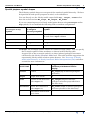
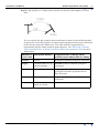
dip The dip symbol is a T shape with variable orientation, and lengths of its two
lines.
You can specify the dip symbol's other attributes as shown in the following table.
A typical use of the dip symbol is to show inferred geological structures calculated
by the Naudy Automatic Model tool. The table includes suggestions for
representing Naudy model solutions point datasets. See "Structure of Naudy
model point datasets" in Naudy Automatic Model interpretation (T43) for more
information.
Dip symbol attribute
Suggested value or Naudy model
solutions point dataset field for display
colour
colour
Z (depth of inferred geological structure)
angle
rotation angle (0 =
(North–South))
strike (strike of inferred geological
structure)
size
length of crossbar
MC_length (length of inferred
geological structure perpendicular to
line direction)
thickness
length of shaft
MC_slope (dip of inferred geological
structure)
–
Thickness of lines
fixed at 0.2 mm
–
T
Library | Help | Top
Attribute in
MAPCOMP
© 2012 Intrepid Geophysics
| Back |