1
Kingcome TSA
Species At Risk (SAR) Database Version 2.7
Training and User’s Manual 2008-09
Training Manual Prepared by:
Astrid M. van Woudenberg, MSc, RPBio
Cascadia Natural Resource Consultants Inc.
108 – 1383 McGill Road
Kingcome, BC
V2C 6K7
User’s Manual Prepared by:
Dave Philp
Forsite Consultants Ltd.
31 March 2009
Kingcome TSA SAR Database Training Manual 2008-09
SAR Database Training Manual
For the Kingcome TSA
For application of Version 2.7
31 March 2009
2
Kingcome TSA SAR Database Training Manual 2008-09
Table of Contents
1.0 Introduction.................................................................................................................. 4
1.1 Background and Rationale....................................................................................... 4
2.0 Kingcome TSA BEC Variants ..................................................................................... 5
3.0 Kingcome TSA Species at Risk................................................................................... 5
3.1 SAR Database Species Characteristics .................................................................... 6
4.0 SAR Database Function............................................................................................... 6
4.1 Key Objectives for the SAR database...................................................................... 6
4.2 Database Structure ................................................................................................... 6
4.3 SAR Locations and Risk Assessment in the Kingcome TSA................................ 11
4.4 Generating Field Cards .......................................................................................... 12
4.5 Database Deployment ............................................................................................ 12
4.6 Database Upgrades................................................................................................. 12
5.0 Due Diligence: Forest Professional Observations of SAR ....................................... 12
5.1 Government Contacts and Websites ...................................................................... 13
6.0 References Cited ........................................................................................................ 14
Appendix 1. Structural Stages and Modifiers (PEM variables from Standards for
Terrestrial Ecosystem Mapping)....................................................................................... 15
Notes: ................................................................................................................................ 16
User’s Manual……………………………………………………………………………19
3
Kingcome TSA SAR Database Training Manual 2008-09
1.0 Introduction
The Species at Risk (SAR) Database is a site-series based management tool developed
specifically for the Biogeoclimatic Ecosystem Classification (BEC) variants within a
particular Timber Supply Area (TSA). The key functions of the database are
1)
to alert forest planners and operators of the potential locations of
Species at Risk (SAR) within specific BEC variants, within a TSA of
interest, and
2)
to provide habitat management guides specific to that particular variant
within the selected TSA.
The potential occurrence of a SAR within a particular variant is established through the
identification of that species’ habitat capability (terrain) and suitability (forest cover or
grassland characteristics, depending on the species). If the unique suite of requisite
features are present, the management tool provides the user with a set of cover features
that should be retained and how (partial cut vs clearcut with reserves, WTP or reserve
design, access development, etc). The SAR database is designed to facilitate habitat
management for SAR at the cutblock level; landscape planning is not addressed, although
the database could be a facilitating component to a landscape planning process.
SAR included in the database in 2008-09 were those specified by the Federal government
Species At Risk Act (SARA) Schedule 1, as well as the Provincial government’s
Identified Wildlife Management Strategy (IWMS 2004) and Section 7 Notices, under the
provincial legislation, Forest and Range Practices Act (FRPA).
The database has been structured so that it can provide both detailed information for
office use and summarized information in the form of a field card. The processes of
accessing the detailed information and printing field cards has been automated by
programming the SAR database into a user-friendly model in MS Access.
1.1 Background and Rationale
The final piece of federal legislation regarding species at risk was passed in 2004. The
federal Species At Risk Act (SARA) requires provincial governments to provide the
mechanism to manage Schedule 1 listed species at risk. The British Columbia provincial
government’s response to the federal legislation was to improve the existing Identified
Wildlife Management Strategy; the upgrade was released June 1, 2004 and is referred to
as IWMS 2004 and is a policy document. Since the release of IWMS 2004, Section 7
Notices for specific Schedule 1 SAR have been released by the provincial government
under the Forest and Range Protection Act (FRPA). Section 7 Notices provide the
management framework for each Forest District for a particular SAR within a landscape
context; each SAR listed has a quota for impact to the Timber Harvest Land Base
(THLB) as well as number of Wildlife Habitat Areas (WHA) where essentially little or
no timber harvest activity is permitted.
4
Kingcome TSA SAR Database Training Manual 2008-09
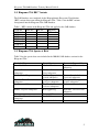
2.0 Kingcome TSA BEC Variants
The SAR database was completed for the Biogeoclimatic Ecosystem Classification
(BEC) variants that occur within the Kingcome TSA. Table 1 lists the BEC variants
incorporated into the Kingcome TSA SAR Database.
Table 1. BEC variants in the Kingcome TSA and applied to the SAR database.
CWH dm
ESSF mw
IDF ww
MH mm 1
CWH ds 2
MH mm 2
CWH vh1
CWH vm1
CWH vm 2
CWH vm 3
CWH ws 2
CWH xm 2
3.0 Kingcome TSA Species at Risk
Table 2 lists the species that were included in the 2008-09 SAR database version for the
Kingcome TSA.
Bandtailed Pigeon
Barn Swallow
Keen’s Myotis
Marbled Murrelet
Canada Goose, occidentalis
subspecies
Coastal Tailed Frog
Northern Goshawk,
laingi subspecies
Northern Pygmy Owl,
swarthi subspecies
Pelagic cormorant,
pelagicus subspecies
Pine Grosbeak,
carlottae subspecies
Red-legged frog
Common Water Shrew, brooksi
subspecies
Double-crested Cormorant
Ermine, anguinae subspecies
Fisher
Great Blue Heron, fannini
subspecies
Grizzly Bear
Townsends Big-eared Bat
Townsends Vole, cowani
subspecies
Western Grebe
Western Screech Owl,
kennicottii subspecies
White-tailed Ptarmigan,
saxatilis subspecies
Wolverine, luscus subspecies
Wolverine, vancouverensis
subspecies
Roosevelt Elk
Sandhill Crane
Short-eared Owl
5
Kingcome TSA SAR Database Training Manual 2008-09
3.1 SAR Database Species Characteristics
The SAR database is best applied to wildlife species with habitat requirements at the
cutblock level, rather than larger ranging species whose life requisites depend on a
landscape scale.
All SAR should still be considered at the landscape level to ensure population
sustainability through dispersal, since the SAR database does not address features at this
scale and only provides guides for the cutblock level.
4.0 SAR Database Function
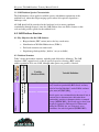
4.1 Key Objectives for the SAR database
• Biogeoclamatic (BEC variant) unit as the key search entity
•
Identification of Wildlife Habitat Areas (WHA’s)
•
Field card extraction on search result
•
Digital image link capability (‘built in’, not yet available)
Office
Database Section
Species at Risk General
Information
Database Mode:
Office/Field Card
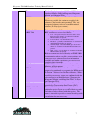
4.2 Database Structure
Table 3 shows the database structure, including each field and its definition. The SAR
database is BEC variant-based, so that all queries depend on selecting a BEC variant
within a particular TSA, not a SAR, although other queries are possible, if desired.
Variable
(Database Field)
Species at Risk
Provincial Status
Variable Definition
English and Latin names for a species that has at the
very least been provincially Blue-listed, and may
also be listed in Schedule 1 under SARA, and may
also occur in IWMS 2004.
Provincial rank of either Blue or Red-listed. Bluelisted species are not immediately threatened, but of
concern due to characteristics that make them
particularly sensitive to human activities or natural
events (MSRM 2002). Red-listed species have been
legally designated as Endangered or Threatened
under the Wildlife Act, are extirpated, or are
candidates for such designation (MSRM 2002).
6
Kingcome TSA SAR Database Training Manual 2008-09
TSA
BEC Unit
Timber Supply Area. As of 31 March 2006 the
database includes SAR for Kingcome, Kingcome,
Merritt, and Okangan TSAs.
Biogeoclimatic Ecosystem Classification Unit.
Wherever possible, the variant was applied; the
subzone is the broadest unit permitted. The ‘un’designated subzone refers to an undifferentiated
subzone (D. Lloyd pers. comm.).
Likelihood of Occurrence Risk of a particular SAR occurring in a particular
in BEC Unit
BEC variant was assessed as follows;
1.
2.
3.
4.
5.
WHA Location
WHA Status
SAR Locations
SAR Specialist Contact
Low – rare species may be classed as such; or less
than about 25% chance of occurrence if suitable
habitat features are present.
Low-moderate – less than 50-50, >25%.
Moderate – generally a 50-50 chance of occurrence if
suitable habitat features are present.
moderate-high – better than 5050, up to about 75%
chance of occurrence if suitable habitat features are
present.
high - >75%, or good chance of occurrence if suitable
habitat features are present.
Risk assessment was based directly on IWMS 2004
documentation where possible, expert opinion, or in
some rare cases estimated based on information
available and author experience; peer review was
sought in latter situations.
Wildlife Habitat Area Location as designated by
Ministry of Environment.
Status of Wildlife Habitat Area Locations as either
proposed or confirmed as per quotas for WHA noted
in Section 7 Notices for each Forest District. Where
possible or necessary, status was confirmed with the
relevant Species at Risk Biologist (J Surgenor for
Kingcome, Merritt, and Kingcome TSAs; O. Dyer
for Okanagan TSA).
Records of species locations requested from and
provided by Conservation Data Centre (CDC).
Name of the biologist who is recognized as a
particular species expert as a result of their research
and other work associated with that species. The
name is intended to provide a contact should specific
consultation become necessary.
7
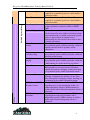
(Feature
Identifiers)
Habitat Capability
Office
Field Card
Kingcome TSA SAR Database Training Manual 2008-09
Site series (talus, rock
outcrop, xeric, sub-xeric,
mesic, sub-hygric, hygric)
Elevation range min (m)
Elevation range max (m)
Critical aspect 1
Critical aspect 2
Slope range
Key microsite topo
features (define: ridge,
Qualitative soil moisture regime classification rather
than quantitative numeric value assigned for the
range of soil moisture characteristics defined for
each variant within the Biogeoclimatic Ecosystem
Classification System.
Minimum elevation in meters a SAR is expected/has
been documented to occur at.
Maxmimum elevation in meters a SAR is
expected/has been documented to occur at.
Any aspect that may have high capability or is
absolutely required by a particular SAR is defined as
South (S), South-East (SE), South-West (SW), West
(W), East (E), North (N), North-East (NE), NorthWest (NW).
As above, although an aspect of secondary
importance
Where possible, a quantitative value of the range of
slope a SAR either requires, prefers, or will tolerate
was provided; for most SAR, such detailed
information is often not yet available.
Key micro-site topographic features required or
preferred by a particular SAR, where available.
Field Card (Feature Identifiers)
Habitat Suitability
bench, cliff, valley bottom,
mid-slope, etc)
Structural stage (PEM
variable; Ref: Standard for
Terrestrial Ecosystem
Mapping)
Structural stage modifier
(PEM variable; Ref: Standard
for Terrestrial Ecosystem
Mapping)
Vet Component
Age Class
Lead Species
Co-dominant Species
Predictive Ecosystem Mapping (PEM) variable of
classified stages (1-7) of forest structure defined by
both age and stand structure. The reference is
Standard for Terrestrial Ecosystem Mapping. A
copy of the table can be found in Appendix 1.
As above, this variable further describes stand
structure, specifically canopy layer. Definitions are
included in the table in Appendix 1.
Yes or No entry defines whether a veteran tree
component is necessary for a particular species
habitat in a particular variant.
Forest Cover Inventory Age Class required by a
particular species in a stand within a particular
variant.
Forest Cover Inventory Lead Species required by a
particular species in a stand within a particular
variant.
Forest Cover Inventory Co-dominant Species
required by a particular species in a stand within a
particular variant.
8
Kingcome TSA SAR Database Training Manual 2008-09
Sub-dominant Species
Detailed Species Biology
Crown Closure
Home Range Size
Movement/Dispersal
Habitat Features Security
Habitat features nesting/breeding
Habitat features foraging
Habitat Threats
Disturbance Threats
GWM (General Wildlife
Measures)-Access
Office
GWM-Havesting and
silviculture
Forest Cover Inventory Sub-dominant Species
required by a particular species in a stand within a
particular variant.
Forest Cover Inventory Percent Crown Closure
required by a particular species in a stand within a
particular variant.
Home range area in hectares for a particular species
within a particular variant if available in IWMS
2004
The amount of area (ha) or distance (m) a species
can be expected to move within a particular variant,
where information is available; movement typically
refers to dispersal from its original nest or
birth/rearing site, but can also refer to intra or interseasonal movements.
One of three critical life requisites: habitat required
by a particular species within a particular variant to
remain concealed from its predators and/or
competitors.
One of three critical life requisites: habitat required
by a particular species within a particular variant for
breeding and/or nesting.
One of three critical life requisites: habitat required
by a particular species within a particular variant for
either hunting prey and/or browsing vegetation.
Specific impacts and their causes that threaten
habitat feature(s) necessary for one of the three
critical life requisites (foraging, security, breeding)
of a particular species within a particular variant.
Specific impacts and their causes that disturb,
interrupt, or terminate the activities of one of the
three life requisites (foraging, security, breeding) of
a particular species within a particular variant.
General Wildlife Measures defined in IWMS
regarding access (road construction, traffic, etc)
either immediately outside a WHA boundary or
within a buffer where limited management activity is
permitted.
General Wildlife Measures defined in IWMS
regarding harvesting and silviculture either
immediately outside a WHA boundary or within a
buffer where limited management activity is
permitted.
9
Kingcome TSA SAR Database Training Manual 2008-09
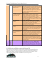
GWM-Pesticides
GWM-Range
Management Guide
GWM-Recreation
Additional Management
Considerations
Clear cut or partial cut
Field Card (Retention)
Wildlife Tree Class (Ref:
Biodiversity Guidebook)
Single tree retention
species
Single tree retention size
[DBH limit or range in
cm]
General Wildlife Measures defined in IWMS
regarding pesticide use either immediately outside a
WHA boundary or within a buffer where limited
management activity is permitted.
General Wildlife Measures defined in IWMS
regarding livestock activity either immediately
outside a WHA boundary or within a buffer where
limited management activity is permitted.
General Wildlife Measures defined in IWMS
regarding recreation activity either immediately
outside a WHA boundary or within a buffer where
limited management activity is permitted.
Any additional information regarding habitat needs
or necessary management that cannot be addressed
by any other database variable (field); sometimes a
more detailed explanation to facilitate understanding
of field entries for a particular species within a
particular variant.
The ‘best’ harvest option has been selected based on
available information for a particular species within
a particular variant; either a clear cut with wildlife
tree patches (WTP) and/or reserves will be defined
as best as possible with the information available, or
a partial cut that will be defined as single tree or
patch retention, and/or with opening size defined
where possible.
Wildlife Tree Classes (1-9) as defined in Appendix 6
of the Biodiversity Guidebook that are required for
retention to meet the life requisite habitat needs of a
particular species within a particular variant.
Preferred species to be retained during block layout
within a particular variant based on/estimated from
habitat features necessary for a particular species’
life requisites.
Preferred diameter size (cm) of single trees that
should be retained during block layout within a
particular variant based on/estimated from habitat
features necessary for a particular species’ life
requisites.
10
Kingcome TSA SAR Database Training Manual 2008-09
Buffer area around single
tree (radius in meters) or
stream (m or ha)
Patch retention size (ha)
(ie: WTP or retention
area of some sort)
Stand structure for
retention
Stand density for
retention
Key stand features for
retention
References
Office
Patch species retention
Reference(s) Cited
The radius (m), or distance from the single tree
selected for retention and the outer limit of its buffer
to ensure windfirmness and/or provide security for a
particular species within a particular variant; if
riparian, the width of the riparian forest adjacent to
the water’s edge that should be retained in a
particular variant.
The size (ha) of the reserved forested area within a
cutblock within a particular variant, pending
available information for a particular species to meet
the habitat needs of its life requisites. Where
information was insufficient, a size range or lower
area limit for Wildlife Tree Patches (WTPs) or other
reserves is estimated.
A brief, simple description, based on available
information, of the forest structure expected to be
retained within a particular variant based
on/estimated from habitat features necessary for a
particular species’ life requisites.
A standardized, brief description of stand density
expected to be retained in a forest reserve, WTP, etc,
within a particular variant, based on/estimated from
habitat features necessary for a particular species’
life requisites.
Any specific stand feature that should be retained,
not already defined by existing database fields, that
is needed for one of the three life requisites of a
particular species within a particular variant.
If a patch of trees, rather than a single tree, has been
selected as the best estimated means to retain life
requisite habitat features of a particular species, this
would be that species’ preferred tree species within a
particular variant.
For most species entered into the database, Identified
Wildlife Management Strategy (IWMS) 2004
provided the most recent species accounts and
management criteria that were used. Other articles,
sources of information are listed here were relevant.
4.3 SAR Locations and Risk Assessment in the Kingcome TSA
CDC records are often masked for security and are not necessarily current for all species.
Therefore, in most cases a risk assessment was required to determine the likelihood of a
SAR presence within a particular variant based on the criteria shown in Table 3. In the
office mode, the database provides a likelihood assessment of presence.
11
Kingcome TSA SAR Database Training Manual 2008-09
4.4 Generating Field Cards
A Field Card can be generated for a particular BEC variant as part of the navigation
results. A print function will generate a formatted Field Card Report from the result of the
navigation/search (BEC variant within a particular TSA).
4.5 Database Deployment
The SAR database application has been developed as a standalone read only application,
that for this fiscal year will be distributed either by CD or downloaded from an FTP site.
It must be installed on the hard drive of the computer it will be used on, and the current
version requires MS Access to be present on that computer.
4.6 Database Upgrades
The SAR database will display the date of most recent upgrade. Nearing the anniversary
date of the last update (30 days), an exception window will be displayed as a reminder to
upgrade the SAR database. The following message will appear:
Information in this database is continually being researched and
updated.
The current SAR database source date is {database date}.
Please Contact Astrid van Woudenberg to request a SAR database
update.
5.0 Due Diligence: Forest Professional Observations of SAR
If a Species at Risk is observed in the field, it should be reported to the Conservation
Data Centre. A standardized form for observations is available on CDC web site
(http://www.env.gov.bc.ca/cdc/contribute.html).
If field guides are to be used to identify SAR in a site, they should not be used in
isolation, unless identification is made by a qualified professional biologist. Rather, field
guides can be used in conjunction with the database. Guides typically indicate broad
habitat types and seasonal periods a species can be expected to be observed in. The SAR
database will provide detailed critical habitat features that can be identified in the field to
facilitate SAR identification. As well, government should be called upon to address
information gaps where distribution and range of SAR occur.
12
Kingcome TSA SAR Database Training Manual 2008-09
5.1 Government Contacts and Websites
Government contacts responsible for SAR in the Kingcome TSA are:
IWMS Regional Contacts
Sean Pendergast
2080 Labieux Rd.
Nanaimo BC V9T 6J9
Phone: 250-751-3150
Fax: 250-751-3103
e-mail:[email protected]
Important government websites:
Conservation Data Centre
www.env.gov.bc.ca/cdc
BC Species and Ecosystem Explorer (database for checking SAR status and relevant
reports)
http://srmapps.gov.bc.ca/apps/eswp/search.do
Identified Wildlife Management Strategy Home Page
(Environmental Stewardship Division, Ministry of Environment)
http://www.env.gov.bc.ca/wld/identified/index.html
- to check Wildlife Habitat Area (WHA) status (approved or pending)
http://www.env.gov.bc.ca/cgi-bin/apps/faw/wharesult.cgi?search=show_approved
13
Kingcome TSA SAR Database Training Manual 2008-09
6.0 References Cited
British Columbia Ministry of Sustainable Resource Management. 2002. One fish, two
fish, red fish, blue fish. Species ranking in British Columbia.
British Columbia Ministry of Water, Land and Air Protection. 2004. Accounts and
Measures for Managing Identified Wildlife. Version 2004. Biodiversity Branch,
Identified Wildlife Management Strategy, Victoria, B.C.
14
Kingcome TSA SAR Database Training Manual 2008-09
Appendix 1. Structural Stages and Modifiers (PEM variables from
Standards for Terrestrial Ecosystem Mapping)
15
Kingcome TSA SAR Database Training Manual 2008-09
Notes:
16
Kingcome TSA SAR Database Training Manual 2008-09
17
Kingcome TSA SAR Database Training Manual 2008-09
18
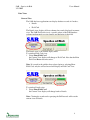
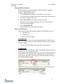
SAR – Species At Risk
User’s Manual
Version 1.0
SAR – Species At Risk
3/31/2009
Users Manual
Table of Contents:
1
2
Overview....................................................................................................................... 1
Installation..................................................................................................................... 2
2.1 System Requirements 2
2.2 Replacing the MSAccess data store 3
3 SAR – Species At Risk ................................................................................................. 4
3.1 Launching SAR…………………………………………………………….. 4
3.2 Navigation
4
3.3 Searching the Database
4
3.3.1 Search Criteria .................................................................................................. 4
3.3.2 Retrieving all SAR Database Records .............................................................. 5
3.3.3 Retrieving Selected SAR Database Records by Search Criteria ...................... 6
3.3.4 Clearing a Search .............................................................................................. 7
3.4 Data Views 8
3.4.1 Current View..................................................................................................... 8
3.4.2 Printing Field Card Reports .............................................................................. 9
3.4.3 Display Grid Properties..................................................................................... 9
3.5 Database Version
12
3.5.1 Date last Updated ............................................................................................ 12
Appendix A. Field Card Report Example ......................................................................... 13
i
SAR – Species At Risk
3/31/2009
Users Manual
Overview
Cascadia Natural Resource Consultants (Cascadia) in cooperation with Tolko Industries
Ltd. Heffley Creek division and Canfor have developed a Species at Risk (SAR) database
application to assist licensees in the Kingcome, Merritt and Okanagan TSA’s make
informed decisions regarding sensitive wildlife habitats and Species at Risk during
strategic and operational planning exercises.
The application allows users to navigate through the custom SAR database and identify
species at risk in by unique BEC zones and other criteria. Navigation results can be
viewed in their entirety or as Field Card Reports of key SAR attributes for each BEC
Variant in a TSA.
Cascadia Natural Resource Consultants have been identified as the initial data custodian
for the SAR database and will be active in updating the SAR database annually for TSA
users. To meet both of these needs the application is deployed two modes;
• Read only for the general user base and;
•
Read / Write / Delete for the data custodian.
1
SAR – Species At Risk
3/31/2009
Users Manual
Installation
The SAR v1.0 data base application is delivered in an installation package called
SAR_Installer.exe .
To install SAR v1.0:
1. Copy the SAR_Installer.exe file to a location on your local machine
2. Double click the SAR_Installer.exe and follow the prompts using the Next button
Use the following settings for optimum installation.
Install Location:
Install Options:
System Requirements
Minimum Requirements:
• Operating System: Windows 2000 or better
•
Applications:
MSAccess 2000 or better
2
SAR – Species At Risk
3/31/2009
Users Manual
Replacing the MSAccess data store
The initial install will load the v1.0 SAR data base to the same location the
application was installed to. The database is called SAR_be.mdb
Periodically the data custodian will release an updated SAR database. To update
your SAR database copy the new SAR_be.mdb to the location the application
was installed to overwriting the previous database.
Note: Some users may want to archive the previous SAR_be.mdb database prior
to replacing it with the new database.
3
SAR – Species At Risk
3/31/2009
Users Manual
SAR – Species At Risk
Launching SAR
To open the SAR database:
1. Select the Windows Start Menu Programs Group
2. Select the SAR Database from the SAR Program Group
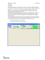
Navigation
Navigation in the SAR database is contained in a single navigation interface.
The interface contains standard windows controls for drop down selection,
window scrolling, minimize, maximize and close.
Searching the Database
Search Criteria
Searching for Species at Risk is achieved through primary and secondary
or optional search criteria. The primary search criteria are BioGeoClimatic
(BEC) zone, sub-zone and variant. The secondary search criteria are TSA,
Species at Risk Provincial Status, Site Series and Maximum Elevation.
4
SAR – Species At Risk
3/31/2009
Users Manual
Note: The data base has been modeled to allow only valid BEC zone, subzone and variant combinations.
Retrieving all SAR Database Records
To Retrieve all SAR Records:
1. Select the Search button without selecting primary or optional search
criteria
This search will return the entire contents of the database in a display grid
Note: The total number of records returned is displayed in the bottom left
of the application window.
5
SAR – Species At Risk
3/31/2009
Users Manual
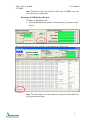
Retrieving Selected SAR Database Records by Search Criteria
To retrieve selected SAR Records:
1. Select the desired Search Criteria using the dropdowns for
Recommended Search BEC and Optional Search. Any combination of
criteria can be used.
2. Select the Search button. Results will be displayed in the display grid.
In the example above 4 records were returned meeting the selected
criteria.
Note that the returned records include BEC zone and sub-zone as per the
criteria. All variants were returned as well as there was no variant
specified in the search.
6
SAR – Species At Risk
3/31/2009
Users Manual
Clearing a Search
To clear a search:
1. Select the Clear button located on the Search Criteria panel.
7
SAR – Species At Risk
3/31/2009
Users Manual
Data Views
Current View
The SAR data base applications can display database records in 2 modes;
• Details
•
Field Card
The Details view displays all data columns for records displayed in current
view. The SAR Field card view is a specific subset of the SAR database
columns implemented to assist planners and biologists in the field.
The Details view is the default display mode.
To switch to Field Card view:
1. Select Show Field Card
the Current View display will change to Field Card. Note that the Print
Field Card Button becomes active.
Note: If a record in the grid has been selected prior to selecting Show
Field Card, only the selected record will display in Field Card View.
To switch to Details view:
2. Select Show Field Card
the Current View display will change back to Details.
Note: Clearing the search and re-querying the SAR records will reset the
current view to Details.
8
SAR – Species At Risk
3/31/2009
Users Manual
Printing Field Card Reports
The Field Card view can be printed to a formatted report containing a
single or multiple SAR record sets.
To print a single SAR record set:
1. Use the Search functionality to locate SAR records of interest
2. Use your left mouse button to select the record to print. The record can
be selected anywhere in the grid
3. Select Show Field Card to switch to Field Card View
The Current View display will change to Field Card and only the
selected record will display.
4. Select Print Field Card
See Appendix A for sample Field Card report
Display Grid Properties
The Display Grid has three distinct properties for altering the data view
• Ascending Sort
•
Column Order
•
Drag and Drop Grouping
Ascending Sort
Each column can be sorted in an ascending alphabetical or numeric order.
Only one column can be sorted. Sorts cannot be combined across columns
To sort a column:
1. Use your left mouse button and single click a column header.
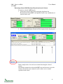
Column Order
Column order can be modified by simply selecting the column header and
moving it to a new location in the grid.
In the example below MaxElevation is currently selected for repositioning
in the Grid. As your cursor drags the column header across the header
portion of the grid yellow arrows appear at each location that will accept
the column header placement.
MaxElevation has been successfully moved to a new position in the grid
9
SAR – Species At Risk
3/31/2009
Users Manual
To reposition a column in the grid:
1. Use your left mouse button to select the column header to move
2. Drag the column header to the new location as indicated by the yellow
placement arrows
3. Release the mouse button
Note: Clearing the search and re-querying the SAR records will reset the
column order to the default order.
Drag and Drop Grouping
Drag and Drop Grouping allows the data grid to be arranged in a
summarized, hierarchical tree structure. This is an extremely powerful
data viewing function that allows any data element in the SAR data base
to become the focus or primary data element in view.
In the example below the Species, Likelihood and TSA have been
grouped. This alters the grid view summarizing the columns. The species,
“Interior Western Screech-Owl” appears once in the grid.
Double clicking a single species reveals the next group item, Likelihood.
In this example there are four likelihood categories available indicating the
there at least four distinct “Interior Western Screech-Owl” records in the
SAR database.
10
SAR – Species At Risk
3/31/2009
Users Manual
Double clicking a likelihood indicator drills down further and reveals that
the “Interior Western Screech-Owl” has a likelihood of being present in
both the Kingcome and the Okanagan TSA.
The lowest level of the example grouping is TSA. Double clicking a TSA
indicator reveals all remaining columns not included in the grouping.
There is no limitation to the number or order of columns in the group.
To create a Data Group:
1. Use your left mouse button to select the column header to group
2. Drag the column header to the drag an drop location in the grid
11
SAR – Species At Risk
3/31/2009
Users Manual
3. Release the mouse button
4. Repeat for the desired columns
Note: Clearing the search and re-querying the SAR records will remove
the Data Group and reset the grid order to the default order.
Database Version
Date last Updated
The Date Last Updated displays the last SAR Database edit date.
Periodically the data custodian will release an updated SAR database.
Once the update database has replaced the previous database the new date
of the last database update will be displayed.
12
SAR – Species At Risk
3/31/2009
Users Manual
Appendix A. Field Card Report Example
13
SAR – Species At Risk
3/31/2009
Users Manual
14