1
Sky Tab
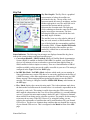
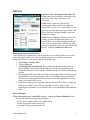
Sky Plot Graphic: The Sky Plot is a graphical
representation of where the satellites are
positioned in the sky. The top of the circle
represents north, the center is straight up, and the
farthest right point is east. The outer blue circle
represents the horizon and the red circle
represents the elevation mask. The light gray
circles radiating out from the center are the zenith
angles in ten degree increments. The lines
bisecting the light gray circles divide the circle
into thirty degree azimuths.
The satellite icons are color coded to indicate if
they are used, unused, or SBAS satellites. Each
icon is labeled with the corresponding satellite's
ID number (PRN). If Leave satellite SNR trails
is checked, the path of the satellites are also
marked by a dotted line as each satellite moves
across the sky.
Status Indicators: The following four messages are displayed around the sky plot to
indicate the current settings configured on other pages:
• Corrections Disabled / SBAS Enabled: displays if Satellite Based Augmentation
System (SBAS) is enabled or disabled. When SBAS is enabled, your Nomad GPS
receiver will attempt to locate, track and use correctional data supplied from an
SBAS satellite in order to improve accuracy. There are a limited number of SBAS
satellites available, so they may not be readily accessible in your area. This setting is
configured in the Type field on the DGPS page.
• In SiRF Bin. Mode / In NMEA Mode: indicates which mode you are running in.
Some applications may require GPS data to be sent to the application in the form of
a NMEA message, where other applications require the GPS data be sent as a SiRF
Binary message. Most mapping and navigation applications can use the NMEA
message. This setting is configured with the NMEA/SiRF Binary radio buttons on
the GPS page.
• Elev. Mask: displays the current elevation mask. This is the minimum angle above
the horizon that a satellite must be located before it is used and is represented on the
sky plot by a red circle. This setting is useful when using the GPS in areas where
there might be obstructions to the view of low flying satellites (e.g. around buildings
or trees). A typical elevation mask setting is between 5 and 15 degrees to eliminate
those satellites from being used to calculate a position. The purpose for this setting is
to increase the accuracy of the GPS. However, by using this setting, you are
reducing the total number of satellites that can be tracked and used by your Nomad
GPS receiver. The idea is to eliminate those satellites that may degrade the accuracy
of your Nomad GPS receiver. This is configured in the Masks section of the GPS
page.
Nomad SatViewer
5