1
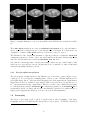
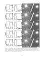
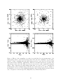
mension), the choice is not critical as long as the projection center lies within the frame. For
compatibility reasons, it is advised to stay with the traditional gnomonic (TAN, for tangential)
projection in such cases. With larger fields the pure tangential projection is inappropriate, and
one is faced with the usual problems confronted by cartographers. It would be outside the
scope of this document to discuss the merits of each projection. For detailed information about
the different projection systems, the user should refer to the latest WCS document. Let us just
mention that equal-area projections (those that conserve relative areas) are often to be preferred
for mapping large sky surveys, because they naturally conserve surface-brightness and/or allow
summing pixel values to measure fluxes. The following are equal-area projections: ZEA, CEA,
COE, BON, GLS, PAR, MOL, AIT, QSC. AIT (Aitoff) is one of the most popular projections for all-sky
maps.
Note that some of the projections (CYP, CEA, COD, COE, COO, COP and BON) require additional
PV xx xx parameters. These parameters can easily be included in a xxxx.head header file with
the same prefix as the output coadded image (which is coadd.fits by default, see the example at
the end of this document).
Centering of the output frame is controlled by the CENTER TYPE parameter. There are three
centering modes:
• ALL: the field is centered in a way that all input images fit into the output frame. This is
the default.
• MOST: the field is centered on the zone of maximum overlap between input images.
• MANUAL: manual centering with the CENTER parameter.
A different centering mode can be used in each dimension; for instance, in 2D images with α, δ
coordinates, “CENTER TYPE ALL,MOST” will apply the ALL mode in α and the MOST mode in δ.
If a single mode is specified, it is applied to all available dimensions.
The CENTER parameters are active in CENTER TYPE MANUAL mode only, and must be used to specify the actual center of the output field, in world units. In the case of angular coordinates, both
the floating point (in degrees) and sexagedecimal formats are accepted: right ascension/longitude
may be written as hh:mm:ss.ss, and declination/latitude as ±dd:mm:ss.ss.
The pixel “scale” (which is the step between pixels at the center of the output frame) can be
computed automatically in each dimension by SWarp. There are five modes specified by the
PIXELSCALE TYPE configuration parameter:
• MEDIAN (the default): the median value of all pixel scales at the center of input frames is
taken as the output pixel scale.
• MIN: the smallest of all pixel scales at the center of input frames is taken.
• MAX: the largest of all pixel scales at the center of input frames is taken.
• MANUAL: manual scaling with the PIXEL SCALE configuration parameter.
• FIT: Pixel scales are automatically computed to have the projected data fitting the output
frame dimensions specified with the IMAGE SIZE configuration parameter.
When right ascension/longitude and declination/latitude are both present, pixel scales computed
by SWarp are made equal in both dimensions to avoid anamorphosis.
12