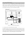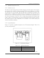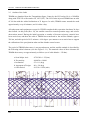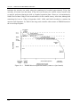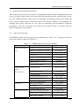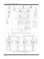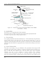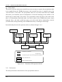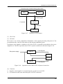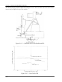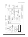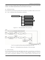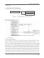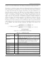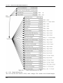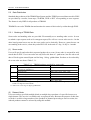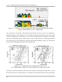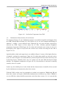
1
TRMM Data Users Handbook Earth Observation Center Global environment change has become a worldwide concern in recent years. Satellite remote sensing is recognized as a powerful and essential means for monitoring global change of earth environment. The Tropical Rainfall Measuring Mission (TRMM) is a joint mission between US and Japan, and it is the first satellite earth observation mission to monitor tropical rainfall, which closely influences to global climate and environment change. TRMM was launched by the H-II rocket from the then NASDA, National Space Development Agency of Japan (From October 2003 on, re-organized as JAXA, Japan Aerospace Exploration Agency)/Tanegashima Space Center in November 1997, and has gone into a circular orbit of altitude 350 km, inclination angle 35˚ and period 90 min. After launch, rainfall observation from TRMM was started, and the designed routine operation period of 3 years was finished at the end of January 2001. And in order to extend observation period, the satellite altitude was raised to about 400km in August 2001, and its mission life is planned until September 2009. TRMM observation data are received at the NASA ground station via Tracking and Data Relay Satellite (TDRS), and some of observation data are transmitted from NASA Goddard Space Flight Center (GSFC) to JAXA/ Earth Observation Center (EOC). Those data are distributed from EOC to users, such as research institute and so on. And many scientific successes have already been achieved from the data about the 3-dimensional structure of the rain obtained by TRMM until now. By extension of mission life, it is expected that the TRMM data is further used broadly over a long period. The purpose of this handbook is to provide users with necessary information for well and spread utilization of TRMM data. We wish TRMM data with this handbook contribute your studies on earth environment preservation, enhancement of climate change analysis, and so on. In closing, I would like to express my gratitude for assistance given by the PIs, National Institute of Information and Communications Technology (NICT), Remote Sensing Technology Center of Japan (RESTEC) and Earth Observation Research Center (EORC) personnel who contributed their busy time. April 2006 Earth Observation Center Japan Aerospace Exploration Agency TRMM DATA USERS HANDBOOK TRMM Data Users Handbook Contents 1 INTRODUCTION................................................................................................................................. 1-1 1.1 1.2 1.3 1.4 2 Purpose................................................................................................................................................ 1-1 Scope ................................................................................................................................................... 1-1 TRMM Mission .................................................................................................................................... 1-2 Responsibilities of US and Japan ........................................................................................................ 1-3 OVERVIEW OF THE TRMM SPACECRAFT................................................................................ 2-1 2.1 Spacecraft ............................................................................................................................................ 2-1 2.1.1 Command and Data Handling Subsystem (C&DH)................................................................... 2-2 2.1.2 Attitude Control Subsystem (ACS).............................................................................................. 2-4 2.1.3 Electrical Subsystem (ES)........................................................................................................... 2-5 2.1.4 Power Subsystem (PWR) ............................................................................................................ 2-5 2.1.5 Radio Frequency Communications Subsystem (COMM)........................................................... 2-6 2.1.6 Thermal Subsystem (THM)......................................................................................................... 2-7 2.1.7 Reaction Control Subsystem (RCS) ............................................................................................ 2-7 2.1.8 Deployables (DEP)..................................................................................................................... 2-8 2.1.9 Structure Subsystem (STR) ......................................................................................................... 2-9 2.2 Overview of the Onboard Instruments............................................................................................... 2-10 2.2.1 Precipitation Radar (PR) ......................................................................................................... 2-10 2.2.1.1 Mission Overview .............................................................................................................. 2-10 2.2.1.2 System Parameters ............................................................................................................ 2-10 2.2.2 TRMM Microwave Imager (TMI)............................................................................................. 2-12 2.2.2.1 Mission Overview .............................................................................................................. 2-12 2.2.2.2 System Parameters ............................................................................................................ 2-12 2.2.3 Visible and Infrared Scanner (VIRS)........................................................................................ 2-13 2.2.3.1 Mission Overview .............................................................................................................. 2-13 2.2.3.2 System Parameters ............................................................................................................ 2-14 2.2.4 Clouds and the Earth's Radiant Energy System (CERES) ....................................................... 2-15 2.2.4.1 Mission Overview .............................................................................................................. 2-15 2.2.4.2 System Parameters ............................................................................................................ 2-16 2.2.5 Lightning Imaging Sensor (LIS) ............................................................................................... 2-16 2.2.5.1 Mission Overview .............................................................................................................. 2-16 2.2.5.2 System Parameters ............................................................................................................ 2-17 2.3 Outline of the Orbit ........................................................................................................................... 2-18 2.4 Mission Operation Phase of TRMM.................................................................................................. 2-19 2.5 Spacecraft and Instrument Operation ............................................................................................... 2-21 2.5.1 Spacecraft Operation ............................................................................................................... 2-21 2.5.2 Instrument Operation ............................................................................................................... 2-22 2.5.2.1 PR .................................................................................................................................... 2-26 2.5.2.2 TMI .................................................................................................................................... 2-27 2.5.2.3 VIRS ................................................................................................................................... 2-27 2.5.2.4 CERES ............................................................................................................................... 2-29 2.5.2.5 LIS .................................................................................................................................... 2-31 2.6 PR Detailed Explanation................................................................................................................... 2-32 2.6.1 Elements and Appearance ........................................................................................................ 2-32 2.6.2 Functions .................................................................................................................................. 2-35 2.6.3 Performance ............................................................................................................................. 2-38 2.6.4 Outline of the Operation........................................................................................................... 2-40 2.6.5 Explanation of the Components ............................................................................................... 2-42 2.6.5.1 Antenna Subsystem ............................................................................................................ 2-42 2.6.5.2 Transmit-Receive Subsystem ............................................................................................. 2-44 2.6.5.3 Signal Processing Subsystem............................................................................................. 2-46 i CONTENTS 2.6.5.4 Structure Subsystem ...........................................................................................................2-50 2.6.5.5 Others.................................................................................................................................2-50 2.6.6 Observation Model ...................................................................................................................2-51 2.6.6.1 Radiometric Model.............................................................................................................2-51 2.6.6.2 Observation Range Model .................................................................................................2-51 2.6.6.3 Geometric Model ...............................................................................................................2-53 2.7 Operation of Post Orbit Boost ...........................................................................................................2-55 2.7.1 Background...............................................................................................................................2-55 2.7.2 Change of Orbit Parameter ......................................................................................................2-55 2.7.3 Operation of PR ........................................................................................................................2-56 2.7.4 Mismatch of Transmit-to-Receive Angle...................................................................................2-56 2.7.5 Influence on Other Sensors.......................................................................................................2-56 2.7.6 Attitude Control System ............................................................................................................2-56 3 OUTLINE OF THE GROUND SYSTEMS.......................................................................................3-1 3.1 TRMM Total Ground System ...............................................................................................................3-1 3.2 TRMM Precipitation Radar Data Processing System .........................................................................3-2 3.2.1 Processing Facility .....................................................................................................................3-6 3.2.2 Verification facility .....................................................................................................................3-7 3.2.3 Operation Planning Facility.......................................................................................................3-7 3.2.4 Precipitation Radar Calibrator (ARC) .......................................................................................3-8 3.3 Earth Observation Data and Information System .............................................................................3-10 3.3.1 Data Distribution and Management System.............................................................................3-11 3.3.2 Data Generation System ...........................................................................................................3-13 3.3.3 Schedule Management System ..................................................................................................3-13 3.3.4 Catalogue Data Distribution System ........................................................................................3-14 3.3.5 On-Line Information System.....................................................................................................3-14 3.3.6 Information Service System ......................................................................................................3-14 3.4 NASA Ground System ........................................................................................................................3-15 3.4.1 Mission Operation Center (MOC) ............................................................................................3-17 3.4.2 NASA Communications.............................................................................................................3-17 3.4.3 Network Control Center (NCC)................................................................................................3-18 3.4.4 Flight Dynamics Facility (FDF)...............................................................................................3-18 3.4.5 Sensor Data Processing Facility (SDPF) .................................................................................3-18 3.4.6 TRMM Science Data and Information System (TSDIS)............................................................3-19 3.4.7 Langley Research Center (LaRC).............................................................................................3-20 3.4.8 Marshall Space Flight Center (MSFC) ....................................................................................3-20 3.4.9 Space Network (SN) ..................................................................................................................3-20 3.4.10 Wallops Flight Facility (WFF) .................................................................................................3-20 4 OUTLINE OF THE TRMM PRODUCTS ........................................................................................4-1 4.1 Data Product........................................................................................................................................4-2 4.1.1 PR ...............................................................................................................................................4-4 4.1.1.1 Product Definition ...............................................................................................................4-5 4.1.1.2 Outline of Processing Algorithm .........................................................................................4-5 4.1.1.3 Data Usage ........................................................................................................................4-34 4.1.2 TMI ...........................................................................................................................................4-35 4.1.2.1 Product Definition .............................................................................................................4-35 4.1.2.2 Processing Algorithm.........................................................................................................4-35 4.1.3 VIRS ..........................................................................................................................................4-41 4.1.3.1 Product Definition .............................................................................................................4-41 4.1.3.2 Processing Algorithm.........................................................................................................4-41 4.1.4 COMB .......................................................................................................................................4-42 4.1.4.1 Product Definition .............................................................................................................4-42 4.1.4.2 Processing Algorithm.........................................................................................................4-42 4.1.5 CERES ......................................................................................................................................4-47 ii TRMM DATA USERS HANDBOOK 4.1.5.1 Product Definition ............................................................................................................. 4-47 4.1.5.2 Processing Algorithm ........................................................................................................ 4-50 4.1.6 LIS ............................................................................................................................................ 4-56 4.1.6.1 Product Definition ............................................................................................................. 4-56 4.1.6.2 Processing Algorithm ........................................................................................................ 4-57 4.2 HDF Format...................................................................................................................................... 4-67 4.2.1 Outline of HDF......................................................................................................................... 4-67 4.2.2 EOSDIS Structures ................................................................................................................... 4-69 4.2.2.1 Swath Structure ................................................................................................................. 4-69 4.2.2.2 Planetary Grid Structure ................................................................................................... 4-70 4.2.3 Formatting Conventions........................................................................................................... 4-72 4.2.3.1 File Structure Figures ....................................................................................................... 4-72 4.2.3.2 File Contents ..................................................................................................................... 4-73 4.2.3.3 Missing Data ..................................................................................................................... 4-73 4.2.3.4 Array Dimension Order..................................................................................................... 4-74 4.2.3.5 Orbit and Granule Definition ............................................................................................ 4-74 4.2.3.6 Scans in a Granule ............................................................................................................ 4-75 4.2.3.7 Time ................................................................................................................................... 4-75 4.2.3.8 QAC Error Type ................................................................................................................ 4-78 4.2.4 Structure of TRMM Data Products .......................................................................................... 4-78 4.2.4.1 PR .................................................................................................................................... 4-79 4.2.4.2 TMI .................................................................................................................................... 4-84 4.2.4.3 VIRS ................................................................................................................................... 4-87 4.2.4.4 COMB................................................................................................................................ 4-88 4.3 TSDIS Tool Kits................................................................................................................................. 4-92 4.3.1 I/O Tool Kit .............................................................................................................................. 4-93 4.3.2 Conversion Tool Kit ................................................................................................................. 4-95 4.3.3 Geolocation Tool Kit ................................................................................................................ 4-96 4.4 OrbitViewer ....................................................................................................................................... 4-96 5 6 EOIS DATA SERVICE ........................................................................................................................ 5-1 5.1 Outline of EOIS Services ..................................................................................................................... 5-1 5.2 Catalog Information Service ............................................................................................................... 5-3 5.2.1 Inventory Information Service.................................................................................................... 5-3 5.2.2 Image Catalog ............................................................................................................................ 5-3 5.3 Data Distribution................................................................................................................................. 5-4 5.3.1 Ordering of TRMM Data............................................................................................................ 5-4 5.3.2 Data Providing Flow.................................................................................................................. 5-6 5.3.3 TRMM Distribution Media ......................................................................................................... 5-7 5.3.4 Online Distribution..................................................................................................................... 5-8 5.3.5 Sample Data Distribution........................................................................................................... 5-8 TRMM OPERATION STATUS, RESULTS and FUTURE PLAN............................................... 6-1 6.1 6.2 6.3 6.4 6.5 On Orbit Initial Check-out Result ....................................................................................................... 6-3 PR Calibration and Validation Result................................................................................................. 6-6 Example of PR Output Product ........................................................................................................... 6-9 Utilization of TRMM Data................................................................................................................. 6-12 TRMM Follow-On ............................................................................................................................. 6-17 APPENDIX Appendix-1 ACRONYMS AND ABBREVIATIONS...................................................................................A1-1 Appendix-2 RELATED INFORMATION ..................................................................................................A2-1 iii CONTENTS List of Figures Figure 1.3-1 Tropical Rainfall and Climate Anomaly ................................................................................1-3 Figure 2.1-1 TRMM Spacecraft..................................................................................................................2-2 Figure 2.1-2 C&DH Subsystem Block Diagram ........................................................................................2-3 Figure 2.1-3 ACS Block Diagram ..............................................................................................................2-4 Figure 2.1-4 Electrical Subsystem Block Diagram.....................................................................................2-5 Figure 2.1-5 Power Subsystem Block Diagram..........................................................................................2-6 Figure 2.1-6 RF Communications Subsystem Block Diagram...................................................................2-7 Figure 2.1-7 Reaction Control Subsystem Block Diagram.........................................................................2-8 Figure 2.2-1 PR Instrument Diagram........................................................................................................2-11 Figure 2.2-2 TMI Instrument Diagram .....................................................................................................2-12 Figure 2.2-3 VIRS Instrument Diagram ...................................................................................................2-14 Figure 2.2-4 CERES Instrument Diagram ................................................................................................2-16 Figure 2.2-5 LIS Instrument Diagram.......................................................................................................2-17 Figure 2.3-1 TRMM Orbit ........................................................................................................................2-18 Figure 2.4-1 TRMM Mission Operations Phases (status as of pre launch) ..............................................2-20 Figure 2.5-1 TRMM 24-Hour Operations Profile.....................................................................................2-22 Figure 2.5-2 Instrument Planning and Scheduling Operations.................................................................2-25 Figure 2.5-3 Cross-track Antenna Pattern Measurement Calibration Timeline .......................................2-27 Figure 2.5-4 Thermal Monitoring .............................................................................................................2-28 Figure 2.5-5 CERES Scan Profile.............................................................................................................2-30 Figure 2.6-1 Appearance of PR ................................................................................................................2-33 Figure 2.6-2 PR Functional Block Diagram .............................................................................................2-34 Figure 2.6-3 Measurement Concept of Precipitation Radar on board TRMM (Orbit altitude = 350 km)2-36 Figure 2.6-4 Transition of PR Operation Modes ......................................................................................2-38 Figure 2.6-5 The PR Subsystems and Components..................................................................................2-42 Figure 2.6-6 Antenna Subsystem Coordinate Axes ..................................................................................2-44 Figure 2.6-7 Transition of FCIF States .....................................................................................................2-49 Figure 2.6-8 Operation of PLO when FCIF-A System is turned on .........................................................2-49 Figure 2.6-9 Function Systems relating to the Signal Intensity of the PR system....................................2-51 Figure 2.6-10 Data Sampling Area during the Observation Mode (Orbit altitude = 350 km)..................2-52 Figure 2.6-11 Data Sampling during External Calibration Mode (Orbit altitude = 350 km) ...................2-52 Figure 2.6-12 Coordinates Axes of the Satellite and PR ..........................................................................2-54 Figure 2.6-13 Scan Track of PR ...............................................................................................................2-54 Figure 3.1-1 TRMM Total Ground System ................................................................................................3-2 Figure 3.2-1 Relationship between the TRMM PR Data Processing System and Foreign Organizations .3-3 Figure 3.2-2 Overall Structure of the TRMM PR Data Processing System ...............................................3-4 Figure 3.2-3 Software Structure of the TRMM PR Data Processing System.............................................3-5 Figure 3.2-4 Operation Configuration (Observation mode) .......................................................................3-6 Figure 3.2-5 Appearance of Precipitation Radar Calibrator .......................................................................3-9 Figure 3.3-1 System Overview of EOIS /DDMS .....................................................................................3-10 Figure 3.4-1 TRMM Ground System Functional Diagram.......................................................................3-16 Figure 4.1-1 TRMM Algorithm Flow Diagram..........................................................................................4-3 Figure 4.1-2 Overall flow chart of precipitation radar algorithm ...............................................................4-4 Figure 4.1-3 Function structure 1A21 processing ......................................................................................4-7 Figure 4.1-4 Relationship between functions of 1A21 processing .............................................................4-7 Figure 4.1-5 Function structure of 1B21 processing ................................................................................4-12 Figure 4.1-6 Relationship between the functions of 1B21 processing .....................................................4-13 Figure 4.1-7 Function structure of 1C21 processing ................................................................................4-15 Figure 4.1-8 Relationship between functions of 1C21 processing ...........................................................4-15 Figure 4.1-9 TMI Level 2A-12 Process Flow Diagram............................................................................4-39 Figure 4.1-10 CERES Data Flow Diagram...............................................................................................4-49 Figure 4.1-11 The scan pattern of two CERES scanners on EOS-AM and EOS-PM spacecraft. ...............4-51 Figure 4.1-12 LIS HDF File Components ................................................................................................4-57 Figure 4.1-13 Time integration at 0ms .....................................................................................................4-62 iv TRMM DATA USERS HANDBOOK Figure 4.1-14 Figure 4.1-15 Figure 4.1-16 Figure 4.1-17 Figure 4.2-1 Figure 4.2-2 Figure 4.2-3 Figure 4.2-4 Figure 4.2-5 Figure 4.2-6 Figure 4.2-7 Figure 4.2-8 Figure 4.2-9 Figure 4.2-10 Figure 4.2-11 Figure 4.2-12 Figure 4.2-13 Figure 4.2-14 Figure 4.2-15 Figure 4.2-16 Figure 4.2-17 Figure 4.2-18 Figure 4.2-19 Figure 4.2-20 Figure 4.4-1 Figure 5.3-1 Figure 5.3-2 Figure 6.1-1 Figure 6.2-1 Figure 6.2-2 Figure 6.2-3 Figure 6.3-1 Figure 6.3-2 Figure 6.3-3 Figure 6.4-1 Figure 6.4-2 Figure 6.4-3 Figure 6.4-4 Figure 6.4-5 Figure 6.4-6 Time integration at 100ms ................................................................................................. 4-63 Time integration at 350ms ................................................................................................. 4-63 Time integration at 400ms ................................................................................................. 4-64 Time integration at 700ms ................................................................................................. 4-65 Primary HDF Data Structures.............................................................................................. 4-68 The Three Levels of Interaction with the HDF File Format................................................ 4-68 Generic Swath Structure ...................................................................................................... 4-70 Generic Planetary Grid Structure......................................................................................... 4-71 Example Product Structure .................................................................................................. 4-73 Granule Structure Time Increases Toward the Right .......................................................... 4-74 Data Format Structure for 1B21 .......................................................................................... 4-80 Data Format Structure for 2A21 .......................................................................................... 4-81 Data Format Structure for 2A23 .......................................................................................... 4-82 Data Format Structure for 2A25 ........................................................................................ 4-82 Data Format Structure for 3A25 ........................................................................................ 4-84 Data Format Structure for 3A26 ........................................................................................ 4-84 Data Format Structure for 1B11 ........................................................................................ 4-85 Data Format Structure for 2A12 ........................................................................................ 4-86 Data Format Structure for 3A11 ........................................................................................ 4-87 Data Format Structure for 1B01 ........................................................................................ 4-88 Data Format Structure for 2B31 ........................................................................................ 4-89 Data Format Structure for 3B31 ........................................................................................ 4-90 Data Format Structure for 3B42 ........................................................................................ 4-91 Data Format Structure for 3B43 ........................................................................................ 4-91 Sample Display of Orbit Viewer ......................................................................................... 4-97 Example of Order Sheet (for TRMM PR scene order) .......................................................... 5-6 Diagram of order flow from request to provision.................................................................. 5-7 PR First Image ....................................................................................................................... 6-4 Cross Calibration between TRMM PR and Ground Radar at Ishigaki Island....................... 6-7 Example of Such a Simultaneous Observation by TRMM PR and CAMPR ........................ 6-8 Distribution Pattern of Radar Reflectivity (2A25) ................................................................6-8 Example of PR Output Product (1B21, 1C21 and 2A25).................................................... 6-10 Example of PR Output Product (2A23)............................................................................... 6-10 Example of TRMM Level 3 Monthly Rainfall Products (May 2000) ................................. 6-11 Rainfall Distribution in January 1998 and 1999.................................................................. 6-12 Sea Surface Temperature from TMI .................................................................................... 6-13 Rainfall Observation Result from VIRS, TMI, PR.............................................................. 6-14 Soil Wetness Estimated from PR......................................................................................... 6-15 Long-wave TOA Flux from CERES ERBE-like Processing............................................... 6-16 Total Number of Lightning Flashes..................................................................................... 6-17 v CONTENTS List of Tables Table 1.4-1 Responsibilities of US and Japan (related to development and S/C operation) ......................1-4 Table 1.4-2 Responsibilities of Japan and US (related to data processing)................................................1-4 Table 2.1-1 Main Characteristics of the TRMM Satellite ..........................................................................2-1 Table 2.2-1 PR System Parameters...........................................................................................................2-11 Table 2.2-2 PR Antenna Subsystem Parameters.......................................................................................2-11 Table 2.2-3 PR Transmitter/Receiver Subsystem Parameters ..................................................................2-11 Table 2.2-4 TMI System Parameters ........................................................................................................2-13 Table 2.2-5 TMI Observation Characteristics ..........................................................................................2-13 Table 2.2-6 TMI Observation Performance..............................................................................................2-13 Table 2.2-7 VIRS System Parameters.......................................................................................................2-15 Table 2.2-8 VIRS Observation Performance ............................................................................................2-15 Table 2.2-9 CERES System Parameters ...................................................................................................2-16 Table 2.2-10 LIS System Parameters........................................................................................................2-17 Table 2.5-1 TRMM Operation Activities Summary.................................................................................2-21 Table 2.5-2 Spacecraft Maneuvers ...........................................................................................................2-25 Table 2.5-3 PR Operational Modes ..........................................................................................................2-27 Table 2.6-1 PR Subsystem and Component .............................................................................................2-32 Table 2.7-1 Comparative Table of Orbit Parameters before and after Orbit Boost..................................2-55 Table 2.7-2 Comparative Table of PR Characteristics before and after Orbit Boost ...............................2-56 Table 3.3-1 Subsystems of DDMS ...........................................................................................................3-11 Table 3.3-2 Function of DDMS................................................................................................................3-12 Table 4-1 The definition of the TRMM products .......................................................................................4-1 Table 4.1-1 TRMM Products......................................................................................................................4-2 Table 4.1-2 TMI Products.........................................................................................................................4-35 Table 4.1-3 VIRS Product ........................................................................................................................4-41 Table 4.1-4 COMB Products ....................................................................................................................4-42 Table 4.1-5 CERES Data Products ...........................................................................................................4-50 Table 4.1-6 Outline of LIS Data Products ................................................................................................4-57 Table 4.1-7 Resultant Area Data...............................................................................................................4-65 Table 4.1-8 Resultant Flash Data..............................................................................................................4-65 Table 4.1-9 Resultant Group Data ............................................................................................................4-65 Table 4.1-10 Function Structure of LIS Data Processing Software..........................................................4-66 Table 4.2-1 GridStructure Fields ..............................................................................................................4-71 Table 4.2-2 TMI Equations.......................................................................................................................4-77 Table 4.2-3 OFFSET Values ....................................................................................................................4-78 Table 4.2-4 Error Fields............................................................................................................................4-78 Table 4.3-1 Tool Kit Categories ...............................................................................................................4-92 Table 4.3-2 Module Structure...................................................................................................................4-96 Table 5.1-1 EOIS Data Services .................................................................................................................5-1 Table 5.2-1 TRMM inventory information managed and provided by EOIS ............................................5-3 Table 5.2-2 TRMM Image Catalog Data....................................................................................................5-3 Table 5.3-1 TRMM products provided by scene order...............................................................................5-4 Table 5.3-2 Items to be specified for Scene Order .....................................................................................5-5 Table 5.3-3 Items to be specified for Standing Order.................................................................................5-6 Table 5.3-4 List of TRMM Distribution Media..........................................................................................5-7 Table 5.3-5 Sample Data Provided tho .......................................................................................................5-8 Table 6-1 Main Events of TRMM Mission ................................................................................................6-2 vi TRMM DATA USERS HANDBOOK 1 INTRODUCTION TRMM, Tropical Rainfall Measuring Mission, was launched by the H-II rocket from Tanegashima Space Center of the then NASDA, National Space Development Agency of Japan (From October 2003 on, re-organized as JAXA, Japan Aerospace Exploration Agency), at AM 6:27 JST, November 28, 1997. This satellite was developed as a joint project between Japan and US, is the first space mission dedicated to measuring rainfall. TRMM mainly observes rain structure, rate and distribution in tropical and subtropical regions, the data plays an important roll for understanding mechanisms of global climate change and monitoring environmental variation. 1.1 Purpose This handbook provides necessary information to users to utilize TRMM data including information related to standard products and also introduces reference information such as TRMM spacecraft, onboard instruments, and ground systems. 1.2 Scope This document consists of six sections and appendices: Section 1 : Describes the purpose and scope of the document and the overview of TRMM mission; Section 2 : Introduces the specifications of the TRMM satellite system and mission instruments, the outline of TRMM orbit, and the TRMM operation policy; Section 3 : Introduces the outline of the ground systems of JAXA and NASA, National Aeronautics and Space Administration; Section 4 : Explains the outline of TRMM products provided by JAXA and HDF format, and introduces various toolkits; Section 5 : Presents the outline of the TRMM products services provided by JAXA/EOIS; Section 6 : Explains TRMM mission status, results and future plan; Appendices : Provide acronym list and reference information. 1-1 Section 1 INTRODUCTION 1.3 TRMM Mission Recent increasing interest for the earth’s environment has identified the importance to grasp the global climate change and understand the mechanisms. The hydrological cycle is a centerpiece of the Earth system and a key to understanding its behavior. Among various components of the water budget, tropical rainfall, which comprises more than two-thirds of global rainfall, is the primary driver of global atmospheric circulation as a hot source. Knowledge of the tropical rainfall and its variability is therefore crucial to understand and to predict the global climate system. In spite of its important role in our lives and global climate, the measurement of global rainfall is extremely difficult because of its high spatial and temporal variabilities. In particular, relatively few rainfall data has accumulated in the tropics and over oceans. Satellite remote sensing is probably the only way to provide reliable rainfall data on a global scale. TRMM is the first space mission dedicated to measuring tropical and subtropical rainfall through microwave and visible/infrared sensors, including the first space borne rain radar. The ocean and the land absorb more than half the solar energy incident to the Earth. This absorbed energy causes the evaporation of the water from Earth surface. The water vapor condenses aloft and then falls as rainfall. The latent heat release in this process is the major energy source in the tropical atmosphere, and the driving force of global circulation. Figure 1.3-1 shows examples of relationship between sea surface temperature and atmospheric circulation in the tropics for the cases of normal and anomalous (El Niño) conditions. Warm water distributed in the western pacific during the normal condition while warm water region shifted to the east in the anomalous condition. Atmospheric circulation changes with the location of warm water region. The TRMM measurements are expected to provide a dataset that will be extremely valuable for understanding and for predicting global climate change and weather anomalies such as related to the sporadic "El Niño" phenomenon. 1-2 TRMM DATA USERS HANDBOOK Figure 1.3-1 Tropical Rainfall and Climate Anomaly (Nominal; left figure, Anomaly; right figure)(Provided by NASA) Main science missions of TRMM are: (1) Monitor tropical rain rate quantitatively and understand the earth’s energy and hydrological cycle. (2) Clarify the actual condition of temporal and spatial changes of tropical rainfall and mechanism to have an effect on atmospheric circulation, and evaluate and develop the numerical model to reproduce and predict them. (3) Establish the method to observe rainfall from space. TRMM completed its nominal three years mission in January 2001, and is continuing to operate. Based on the latest mission analysis about necessary fuel for a controlled reentry, TRMM lifetime will be 1.5 years shorter than the previous estimate. Consequently, the satellite altitude was raised to about 400km in August 2001, in order to extend observation period. After that, although the remaining fuel was at its limit for controlled reentry in September 2005, JAXA and NASA decided to continue the mission until September 30, 2009 for the long-term scientific achievements of TRMM instead of the reentry. 1.4 Responsibilities of US and Japan The TRMM project was proposed and approved at the SSLG held in June 1986, and since then it has being promoted as a joint project between US and Japan mainly by NASA and JAXA. Table 1.4-1 shows the responsibilities of US and Japan on the development and operation of the TRMM systems, and Table 1.4-2 shows the responsibilities on the data processing. 1-3 Section 1 INTRODUCTION TRMM is a US-Japan joint project. In the project, Japan (CRL, Communications Research Laboratory (Currently named NICT, National Institute of Information and Communications Technology), and JAXA) provided the Precipitation Radar (PR) and the launch of the TRMM satellite by H-II rocket. The US provided the spacecraft bus and the four sensors except for the PR and operates the TRMM satellite. NASA/Goddard Space Flight Center (GSFC) via Tracking and Data Relay Satellite (TDRS) performs the on-orbit spacecraft operation. Table 1.4-1 Responsibilities of US and Japan (related to development and S/C operation) Primary Elements H-II Rocket S/C Bus Precipitation Radar (PR) TRMM Microwave Imager (TMI) Visible Infrared Scanner (VIRS) Clouds and the Earth’s Radiant Energy System (CERES) Lightning Imaging Sensor (LIS) S/C Tracking and Operation Data System JAXA Japan NASA US ○ ○ ○ ○ ○ ○ ○ ○ ○ ○ Telemetry and science observation data of TRMM is formatted in CCSDS packet basis, and then transmitted to the White Sands station via TDRS. Pre-processing (Level 0 processing) of all data and higher level processing of PR, TMI, and VIRS data is conducted at GSFC. Level 0 processed CERES and LIS data is transmitted to Langley Research Center and Marshall Space Flight Center of NASA, respectively. However, CERES has suspended operation after May 29th 2001 because it experienced problems with its power source. PR Level 0 data is also transmitted to Japan, and its higher level processing is performed at the JAXA Earth Observation Center (EOC). The higher-level products (Level 1-3 products) produced by EOC or GSFC are distributed to users, which include many scientists in the fields of climatology, meteorology, hydrology etc., in Japan, US and various other countries. JAXA’s Earth Observation Research Center (EORC) promotes scientific research using TRMM data and provides researchers with scientific datasets. Table 1.4-2 Responsibilities of Japan and US (related to data processing) Primary Elements Data Receiving Preprocessing of All Data Higher Level Processing of PR Higher Level Processing of TMI Higher Level Processing of VIRS Higher Level Processing of CERES Higher Level Processing of LIS 1-4 JAXA Japan ○ NASA US ○ ○ ○ ○ ○ ○ ○ TRMM DATA USERS HANDBOOK 2 OVERVIEW OF THE TRMM SPACECRAFT This chapter provides the overview of the TRMM spacecraft subsystems and its onboard instruments. 2.1 Spacecraft Table 2.1-1 shows the main characteristics of the TRMM satellite. Table 2.1-1 Main Characteristics of the TRMM Satellite Launch weight Launcher Launch date (JST) Altitude Inclination Shape Approx. 3.62 t H-II Rocket November 28, 1997 Approx. 350 km (Approx. 402.5km*) Approx. 35 degrees At lift-off: 5.1 m (length), 3.7 m (diameter) In orbit: 5.1 m (length), 14.6 m (in paddle direction) Weight Total: 3620 kg [3524 kg] Fuel: 890 kg Dry weight: 2730 kg [2634 kg] Power Approx. 1100 W [Ave. 850 W] Attitude control Zero momentum three-axis stabilized Data transmission Via TDRS 32Kbps (Real Time), 2Mbps (Play Back) Design life 3 years and 2 months Mission instrument Precipitation Radar (PR) TRMM Microwave Imager (TMl) Visible and Infrared Scanner (VIRS) Clouds and the Earth’s Radiant Energy System (CERES) Lightning Imaging Sensor (LIS) [ ] means the measured value. *: Post orbit boost (August 25, 2001) The TRMM Observatory is comprised of a main body structure, nine housekeeping subsystems, and five science instruments. This section provides a brief overview of the TRMM spacecraft subsystems. The subsystems that comprise the TRMM spacecraft are as follows: a. b. c. d. e. f. g. h. i. Command and Data Handling Subsystem (C&DH) Attitude Control Subsystem (ACS) Electrical Subsystem (ES) Power Subsystem (PWS) Radio Frequency (RF) Communications Subsystem (COMM) Thermal Subsystem (THM) Reaction Control Subsystem (RCS) Deployables (DEP) Structure Subsystem (STR) 2-1 Section 2 OUTLINE OF THE TRMM SATELLITE Figure 2.1-1 provides a graphical description of the TRMM spacecraft. Figure 2.1-1 TRMM Spacecraft 2.1.1 Command and Data Handling Subsystem (C&DH) The C&DH provides redundant hardware and the software necessary to ingest, validate, and distribute commands, various S/C clocks needed to meet all timing requirements, execution of time tagged commands, onboard data storage, and a capability to store commands and tables. The C&DH also provides dual telemetry output, I- and Q-Channels and various telemetry encoding schemes (Reed-Solomon (R-S), Cyclic Redundancy Checks (CRC), and Convolutional Encoding). The C&DH consists of two strings designated as prime and redundant. Each string includes the following components: a. b. c. d. e. f. Uplink card Downlink card Clock card Spacecraft Processor ACS Processor 2.2 Gbits of memory Data storage of approximately 210 minutes is provided by the C&DH in the form of solid-state recorders (Bulk Memory Cards). Figure 2.1-2 provides a block diagram of the TRMM C&DH 2-2 TRMM DATA USERS HANDBOOK subsystem. SIDE B FLIGHT DATA SYSTEM (FDS) SIDE A ATTITUDE CONTROL 1773 BUS BC ACS PROCESSOR RT to Side B Uplink I/F LVPC CLOCK RT LVPC TRANSPONDER GQ I S T D N UPLINK I/F RT SPACECRAFT 1773 BUS LVPC GQ I S T D N LVPC BC S/C PROCESSOR from FDS B Downlink I/F BC INSTRUMENT 1773 BUS MEMORY 2.2 Gbit DOWNLINK INTERFACE I-CHANNEL Q-CHANNEL GSTDN-CHANNEL from FDS B to FDS B Downlink I/F Downlink I/F L V P C :L ow V oltage Pow er C onnector S /C :S pacecraft G S T D N : G round Station Figure 2.1-2 C&DH Subsystem Block Diagram 2-3 Section 2 OUTLINE OF THE TRMM SATELLITE 2.1.2 Attitude Control Subsystem (ACS) The ACS provides autonomous control of the observatory and maintains pointing control to 0.4˚ and pointing knowledge to 0.2˚. Redundant hardware and software is provided to meet the science objectives. The ACS consists of an Inertial Reference Unit (IRU) with three two-axis gyros, two Three Axis Magnetometers (TAM), two Coarse Sun Sensor (CSS) units (8 sensors total), two two-axis Digital Sun Sensor (DSS) units, three dual-wound Magnetic Torque Bars (MTBs), a single Earth Sensor Assembly (ESA), a prime and backup Attitude Control Electronics (ACE), four Reaction Wheel Assemblies (RWA), a prime and redundant ACS Processor (housed in the FDS), and an Engine/Valve Driver (EVD). The Gimbal and Solar Array Control Electronics (GSACE) controls the High Gain Antenna System (HGAS) and the Solar Array Drive Assemblies (SADA). Figure 2.1-3 provides a block diagram of the ACS. Coarse Sun Sensors (8) Reaction Wheels (4) Digital Sun Sensors (2) Magnetic Torquer Bars (3) Inertial Reference Unit (Three 2-Axes) Flight Data System - B Flight Data System - A Engine Valve Driver (A&B) Three Axes Magnetometers (2) Earth Sensor Assembly ACE-B Attitude Control Electronics-A Attitude Control System - A Solar Arrays GSACE-B Gimbal Solar Array Control Electronics-A High Gain Antenna Figure 2.1-3 2-4 ACS Block Diagram TRMM DATA USERS HANDBOOK 2.1.3 Electrical Subsystem (ES) The ES provides power switching and distribution, optical command and telemetry routing, and discrete telemetry and command distribution. The ES also provides pyrotechnics, launch vehicle interface support, and special test interfaces. The ES is comprised of two Power Switching and Distribution Units (PSDUs), power distribution modules located in the GSACE, and the electrical and optical harnessing. Figure 2.1-4 provides a block diagram of the ES. POWER SUBSYSTEM UNSWITCHED POWER UNSWITCHED POWER SWITCHED POWER SWITCHED POWER SPSDU GSACE SWITCHED HIGH POWER Other functions NOT associated with the Electrical Subsystem PYROTECHNIC CONTROL 1773 BUS UNSWITCHED POWER SWITCHED POWER DISCR ETE COMMANDS SERIAL COMMANDS CLOCK DISTRIBUTION IPSDU DISCR ETE TELEMETRY SERIAL TELEMETRY SPECIAL MODE NOTIFICATION POWER SUBSYSTEM Figure 2.1-4 Electrical Subsystem Block Diagram 2.1.4 Power Subsystem (PWR) The PWR is a Peak Power Tracking system consisting of two Super Nickel-Cadmium Batteries, four solar panels (mounted as two wings of two solar panels each), and the Power System Electronics (PSE). The PWR provides 1100 watts of power and is connected directly to the Essential and Non-Essential Buses. The PSE consists of the Power System Interface Box (PSIB), Standard Power Regulator Unit (SPRU) and the Power Bus Interface Unit (PBIU). The PSIB is a microprocessor based unit that provides the interface between the PWR and the FDS. The PSIB also performs PWR monitoring 2-5 Section 2 OUTLINE OF THE TRMM SATELLITE and control functions such as individual Battery Cell voltage monitoring and Amp Hour Integration control of the SPRU. The SPRU provides peak power from the solar array and charge control for the batteries using Voltage/Temperature and Constant Current Control circuitry. The PBIU contains the battery and bus relays and directs power to the Essential and Non-Essential busses. It also contains the battery and bus current shunts for monitoring current flow through the system. Figure 2.1-5 shows a block diagram of the PWR. PSE Electronics Power System Interface Box (PSIB) Standard Power Regulator Unit (SPRU) Power Module Power Bus Interface Unit (PBIU) Solar Array Batteries Essential Bus Power Signal Figure 2.1-5 Power Subsystem Block Diagram 2.1.5 Radio Frequency Communications Subsystem (COMM) The COMM is designed to provide real-time communications through the TDRS Space Network (SN). This is accomplished by using the deployable HGA or the two Omni antennas. The HGA antenna will provide nearly hemi-spherical coverage, and the Omni antennas will also provide nearly spherical coverage. The TRMM design includes two NASA Standard Second Generation User Transponders. Figure 2.1-6 shows a block diagram of the COMM for TRMM. 2-6 TRMM DATA USERS HANDBOOK OMNI RHCP TR A N SPO N D ER A Directional Couplers DIPLEXER RHCP RF Combiner HYBRID Antennas REC TRANS SW3 HYBRID POWER AMPS HGA BRF BRF CIR RHCP SW2 CIR SW4 APS TR A N SPO N D ER B DIPLEXER LHCP Figure 2.1-6 SW1 TRANS REC RF Communications Subsystem Block Diagram 2.1.6 Thermal Subsystem (THM) The THM provides the components and equipment in order to maintain the thermal environment of the observatory during all mission modes. There are two types of components included in the THM design, passive and active components. Passive components include thermal blankets, louvers, thermal coatings, and some temperature sensors. Active components include heater elements, heat pipes, thermostats, and Solid State Temperature Controllers. 2.1.7 Reaction Control Subsystem (RCS) The RCS provides the propulsion capability required for orbit maintenance, attitude control during orbit maneuvers, and the safe end of life ocean disposal. The RCS also provides the capability to perform back-up momentum wheel unloading and yaw maneuvers. The implementation of either of these back-up capabilities requires two or more ACS component failures, and therefore no fuel has been budgeted for these capabilities. The RCS consists of twelve Rocket Engine Modules (REMs), five Fill and Drain Valves, Pressure Transducers, Regulators, Propellant Control Module (PCM), Pressure Transducers, Propellant and Propulsion tanks. Figure 2.1-7 provides a functional block diagram of the RCS. 2-7 Section 2 OUTLINE OF THE TRMM SATELLITE Fill and Drain Valves (5) GN 2 Pressurant Tank Pressure Transducer (high) Pyrotechnic Valve Redundant Regulator Tank 1 (forward) Fill and Drain Module Propellant Tank Module Tank 2 (aft) N2H 4 Propellant Tanks (2) N2H 4 Pressure Transducers (2) (precision) Propellant Control Module Filters (2) Tank Valve -Pitch +Pitch -Yaw +Yaw -Roll +Roll -Roll +Roll Isolation Valves (4) -Yaw +Yaw -Pitch +Pitch Roll Thrusters (4) Delta-V Thrusters (8) Figure 2.1-7 Reaction Control Subsystem Block Diagram 2.1.8 Deployables (DEP) The TRMM DEP consists of a High Gain Antenna Deployment and Pointing System (HGAD/PS), the Solar Array Deployment and Drive System (SADDS), and a Gimbal and Solar Array Control Electronics (GSACE) box. The High Gain Antenna (HGA) will be utilized for normal telemetry communications, provides a two-axis Pointing System (PS) for tracking, and a High Gain Antenna Deployment System (HGADS) to deploy and support the HGA and PS. The SADDS consists of two two-panel Solar Array (SA) wings and two Solar Array Drive Assemblies (SADA). The GSACE controls the position of both the HGA pointing system and the SA rotary actuators in the SADA. 2-8 TRMM DATA USERS HANDBOOK 2.1.9 Structure Subsystem (STR) The STR is categorized to two kinds of structure; they are the main structure and the secondary structure. The main structure is under load by stress by bending, shearing and twist of satellite whole, during launch, land transportation and handling on ground. The secondary structure is not under load by stress of satellite whole. The STR is constructed from the following elements. LBS: Lower Bus Structure Element Name Radial Interface Beam Central Cylinder Honeycomb Equipment Panel Upper Deck Lower Deck Aft Skirt Stub Skirt Intercostals Quantity 9 2 1 4 1 1 1 1 1 PTM: Propellant Tank Modu1e LISP: Lower Instrument Support Platform ISP: Instrument Support Platform UISP: Upper Instrument Support Platform RWM: Reaction Wheel (RW) Modu1e Inertial Reference Unit (IRU) Mounting Plate The UISP supports TMI, VIRS, four thrusters for orbit maneuver and front omni antenna. The ISP supports RW, IRU and PR. PR is mounted to the ISP and LBS by using kinematic mount. CERES and LIS are mounted to the LISP. Stub Skirt is jointed to PAF of H-II launch vehicle by using marman clamp. Main material of STR is Aluminum 6061-T651, Aluminum 7075-T73, Aluminum 7050-T7451 and Aluminum Honeycomb. In the kinematic mount for PR mounting, A mount (three-degree- of freedom) and B mount (two-degree-of freedom) are manufactured by Titanium. Each element of STR is joined by using mainly Aluminum rivets. 2-9 Section 2 OUTLINE OF THE TRMM SATELLITE 2.2 Overview of the Onboard Instruments The TRMM observatory includes five science instruments, namely the Precipitation Radar (PR), the TRMM Microwave Imager (TMI), the Visible and Infrared Scanner (VIRS), the Clouds and the Earth's Radiant Energy System (CERES), and the Lightning Imaging Sensor (LIS). TRMM has three instruments (PR, TMI, and VlRS) in its rainfall measurement package, to obtain tropical and subtropical rainfall measurements, rain profiles, and brightness temperature. TRMM has the only passive microwave instrument (TMI) in an inclined orbit and the only rain radar (PR) in space. The three rain instruments are providing the most complete rain data set (to date) in order to generate climate models and perform severe storm studies. The two additional instruments flown on-board TRMM are the CERES and LIS. CERES and LIS are flown on board TRMM as instruments of opportunity for the Earth Observation System Program. The CERES instrument measures the Earth's radiation budget, and the LIS instrument investigates the global distribution of lightning. 2.2.1 Precipitation Radar (PR) 2.2.1.1 Mission Overview The Precipitation Radar (PR) is the primary instrument onboard TRMM. The most innovative of the five TRMM instruments, the PR is the first quantitative rain radar instrument to be flown in space. The major objectives of the PR instrument are as follows: a. b. Provides a 3-dimensional rainfall structure Achieves quantitative measurements of the rain rates over both land and ocean When properly combined with TMI measurements, the PR data is instrumental in obtaining the height profile of the precipitation content, from which the profile of latent heat release from the Earth can be estimated. The rain rate is estimated from the radar reflectivity factor when the rain rate is small by applying conventional algorithms used for ground-based radar. For large rain rates, a rain attenuation correction is made using the total-path attenuation of land or sea surface echoes. 2.2.1.2 System Parameters Figure 2.2-1 provides a graphical description of the PR instrument diagram. Table 2.2-1, Table 2.2-2 and Table 2.2-3 provide system parameters, Antenna subsystem parameters and 2-10 TRMM DATA USERS HANDBOOK Transmitter/Receiver subsystem parameters respectively. Figure 2.2-1 PR Instrument Diagram Table 2.2-1 PR System Parameters Radar Type Frequency Active Phased-array Radar 13.796 GHz and 13.802 GHz (Two-channel frequency agility) Swath Width ~ 215 km* Observable Range From surface to height ≥ 15 km* Range Resolution 250 m Horizontal Resolution 4.34 ± 0.12 km (at nadir)* Sensitivity S/N per pulse ≥ 0 dB for 0.5 mm/h rain at rain top* Number of Independent Sample 64 Data Rate 93.5 kbps Weight 465 kg Power 213 W *: For pre orbit boost. See Section 2.7 about parameters of post orbit boost (August 2001). Table 2.2-2 PR Antenna Subsystem Parameters Antenna Type Beam Width Aperture Scan Angle Gain Table 2.2-3 128-element slotted waveguide array antenna 0.71 deg. x 0.71 deg. 2.1 m x 2.1 m ± 17 deg. ≥ 47.4 dB PR Transmitter/Receiver Subsystem Parameters Transmitter Type Peak Power Pulse Width Pulse Repetition Frequency (PRF) Dynamic Range Solid-State Power Amplifiers (SSPA) (x 128) 700 W 1.6 µs x 2 ch. 2776 Hz 81.5 dB 2-11 Section 2 OUTLINE OF THE TRMM SATELLITE 2.2.2 TRMM Microwave Imager (TMI) 2.2.2.1 Mission Overview The TRMM Microwave Imager (TMI) is a Multi-channel dual-polarized passive microwave radiometer. TMI utilizes nine channels with operating frequencies of l0.65 GHz, 19.35 GHz, 21.3 GHz, 37 GHz, and 85.5 GHz. The TMI instrument provides data related to the rainfall rates over the oceans, but less reliable data over land, where non-homogeneous surface emissions make interpretation difficult. The TMI instrument is similar to the SSM/I instrument currently in orbit on the Defense Meteorological Satellite Program spacecraft. The TMI data combined with the data from the PR and VIRS also utilized for deriving precipitation profiles. The TMI instrument has a single operational mode and no commandable redundancy. Accordingly, command procedures are minimal and focus on power and heater control. TMI essentially has two modes, OFF and ON. Two external calibrators on the stationary shaft are used to perform calibrations during each instrument rotation (scan). The instrument spins at a rate of 31.6 RPM. Each scan begins with 130˚ of scene data, followed by a cold reference measurement and then a hot load reference measurement. These reference measurements, along with the known temperatures of the calibration loads, serve to calibrate the scan. 2.2.2.2 System Parameters Figure 2.2-2 provides a graphical description of the TMI instrument diagram. Table 2.2-4 provides the TMI system parameters, Table 2.2-5 provides the observation characteristics and Table 2.2-6 provides the observation performance. Figure 2.2-2 2-12 TMI Instrument Diagram TRMM DATA USERS HANDBOOK Table 2.2-4 TMI System Parameters Observation Frequency 10.65, 19.35, 21.3, 37 and 85.5 GHz Polarization Vertical / Horizontal (21.3 GHz Channel : Vertical only) Horizontal Resolution 6 - 50 km* Swath Width ~ 760 km* Scan Mode Conical Scan (49 deg.) Data Rate 8.8 kbps Weight 50 kg Power 39 W *: For pre orbit boost. See Section 2.7.5 about parameters of post orbit boost (August 2001). Table 2.2-5 TMI Observation Characteristics Footprint size (km)* Polari Integral Center Freq. Width Band time Perpendicular to (GHz) (MHz) Scan direction zation (µs) scan direction 1 10.65 V 100 6.6 63.2 36.8 2 10.65 H 100 6.6 63.2 36.8 3 19.35 V 500 6.6 30.4 18.4 4 19.35 H 500 6.6 30.4 18.4 5 21.3 V 200 6.6 27.2 18.4 6 37.0 V 2000 6.6 16.0 9.2 7 37.0 H 2000 6.6 16.0 9.2 8 85.5 V 3000 3.3 7.2 4.6 9 85.5 H 3000 3.3 7.2 4.6 *: For pre orbit boost. See Section 2.7.5 about parameters of post orbit boost (August 2001). Table 2.2-6 TMI Observation Performance 1 2 3 4 5 6 7 Center Freq. (GHz) 10.65 10.65 19.35 19.35 21.3 37.0 37.0 Polarization V H V H V V H Beam efficiency (%) 93 93 96 96 98 91 92 Receiving gain (K) 0.975 0.975 1.045 1.045 1.196 0.783 0.783 8 85.5 V 82 1.165 9 85.5 H 85 1.165 Band Objective Region Very strong rain Very strong rain Strong rain Strong rain Vapor Light rain Light rain Strong rain Light rain Strong rain Light rain Ocean Ocean Ocean Ocean Ocean Land/Ocean Land/Ocean Land Ocean Land Ocean 2.2.3 Visible and Infrared Scanner (VIRS) 2.2.3.1 Mission Overview The VIRS instrument is a cross-track scanning radiometer, which measures scene radiance in five spectral bands, operating in the visible through infrared spectral regions. VIRS is similar to instruments flown on other NASA and NOAA meteorological satellites. Comparison of the microwave data with VIRS visible and infrared data is expected to provide the means whereby 2-13 Section 2 OUTLINE OF THE TRMM SATELLITE precipitation can be estimated more accurately than by visible and infrared data alone. The VIRS instrument serves as a background imager and provides the cloud context within which the passive microwave and radar observations are made. Data from the VIRS instrument is used in rain estimation algorithms based primarily on the passive and active microwave sensors. The VIRS instrument possesses a radiative cooler, a Solar Calibrator door, an Earth Panel shield, and a Solar Panel shield. The Earth panel shield is deployed to block the Earth's reflection, and the Solar Panel shield prevents the sun from shining into the VIRS. 2.2.3.2 System Parameters Figure 2.2-3 provides a graphical description of the VIRS instrument diagram. Table 2.2-7 provides the VIRS system parameters and Table 2.2-8 provides the observation performance. Figure 2.2-3 2-14 VIRS Instrument Diagram TRMM DATA USERS HANDBOOK Table 2.2-7 VIRS System Parameters Scan angle ± 45 degrees, 720 km* at ground 360 degrees 98.4 rpm IFOV 6.02 mrad 2.11 km (nadir)* Optics Cassegrain optics Spectroscopy With filter The focal plane is the same for all bands. Focal Plane Silicon Photo-diode (0.63µm) HgCdTe (1.6, 3.75, 10.8, 12 µm) Detector Cooling Radiator Cooling temperature 117 K Calibration Blackbody, Solar diffusion board, Deep space Data Rate 50 kbps (Daytime) Weight 49 kg Power 53 W *: For pre orbit boost. See Section 2.7.5 about parameters of post orbit boost (August 2001). Swath Width Scan Angle Rotation Rate IFOV Table 2.2-8 Band 1 Objective Clouds mapping during daytime Center wavelength (µm) Band width (µm) SNR/NE∆T Calibration accuracy (%) 0.63 0.10 100 10 VIRS Observation Performance Band 2 Identification between water and ice 1.61 0.06 100 10 Band 3 Band 4 Band 5 Vapor Temperature at the top of clouds Vapor 3.75 0.38 0.06K 5 10.80 1.00 0.06K 5 12.00 1.00 0.06K 5 2.2.4 Clouds and the Earth's Radiant Energy System (CERES) 2.2.4.1 Mission Overview The CERES experiment will help reduce one of the major uncertainties in predicting long-term changes in the Earth's climate. Radiant fluxes at the top of the Earth's atmosphere (TOA) were measured by the Earth Radiation Budget Experiment (ERBE), not merely as an undifferentiated field, but with reasonable separation between fluxes originating from clear and cloudy atmospheres. It was also discovered from ERBE that clouds have a greater affect on the TOA fluxes than was previously believed, but details of the process are not yet fully understood. The CERES experiment will attempt to provide a better understanding of how different cloud processes, such as convective activity and boundary-layer meteorology, affect the TOA fluxes. This understanding will help determine the radiative flux divergence, which enters directly into physically based, extended-range weather and climate forecasting. CERES will also provide information to determine the surface radiation budget, which is important in atmospheric energetics, studies of biological productivity, and air-sea energy transfer. 2-15 Section 2 OUTLINE OF THE TRMM SATELLITE Since September 1998, however, CERES operated intermittently to acquire science data for only campaign purpose, because an anomaly occurred on the power source of data collection system (DAA) of CERES in August 1998. Moreover, CERES operation was completely terminated since May 29 2001. 2.2.4.2 System Parameters Figure 2.2-4 provides a graphical description of the CERES instrument diagram. Table 2.2-9 provides system parameters. Figure 2.2-4 CERES Instrument Diagram Table 2.2-9 CERES System Parameters Observation Band Horizontal Resolution Swath Width Scan Mode Data Rate Weight Power 2-16 0.3 – 5 µm (short Wave Channel) 8 – 12 µm (Long Wave Channel) 0.3 ~> 50 µm (Total Wave Channel) 10km (nadir) Scan Angle: ± 82 deg. Cross-Track Scan or Biaxial Scan 8.5 kbps 45.5 kg 47 W TRMM DATA USERS HANDBOOK 2.2.5 Lightning Imaging Sensor (LIS) 2.2.5.1 Mission Overview The LIS is an optical staring telescope and filter imaging system that acquires and investigates the distribution and variability of both intracloud and cloud-to-ground lightning over the Earth. The LIS data also is used with PR, TMI and VIRS data to investigate the correlation of the global incidence of lightning with rainfall and other storm properties. The data from the LIS instrument can be correlated to the global rates, amounts, and distribution of precipitation, and to the release and transport of latent heat. LIS is a single string instrument with multiple single points of failure. The LIS instrument was powered ON during the initial instrument activation, and remains powered in that configuration for the duration of the mission (barring any unforeseen anomalous conditions). 2.2.5.2 System Parameters Figure 2.2-5 provides a graphical description of the LIS instrument diagram. Table 2.2-10 provides system parameters. Figure 2.2-5 LIS Instrument Diagram Table 2.2-10 LIS System Parameters Observation Band 0.777655 µm Horizontal Resolution 4 km (nadir)* Swath Width ~ 600 km* Data Rate Ave. 6 kbps Weight 18 kg Power 42 W *: For pre orbit boost. See Section 2.7.5 about parameters of post orbit boost (August 2001). 2-17 Section 2 OUTLINE OF THE TRMM SATELLITE 2.3 Outline of the Orbit TRMM was launched from the Tanegashima Space Center by the H-II rocket No. 6 of NASDA along with ETS-VII on November 28, 1997 (JST). The H-II rocket injected TRMM into an orbit of 380 km with the orbital inclination at 35 degrees. In orbit, TRMM rotates around the earth approximately every 90 minutes, and 16 orbits a day. All subsystems and equipments except for CERES completed their operation checkouts 26 days after launch. At this point (Dec. 29), the satellite entered a normal operation stage, and science observation started. During the initial operation, a number of descent trajectory controls have been carried out, and then the orbit of TRMM was transferred to the mission altitude, approx. 350 km, and orbit period of 91.5 minutes. A 90 degree yaw maneuver was carried out to support the calibration of the precipitation radar and the altitude control sensor. The period of TRMM observatory is sun-asynchronous, and the satellite attitude is described by the following orbital elements (see also Figure 2.3-1). The nominal values of these elements for TRMM observatory are approximately as follows (as of orbit altitude = 350 km): a. Semi Major Axis b. Eccentricity c. Inclination d. Argument of Perigee e. Orbit Period : 6728.388 ± 1.25 (km) : 0.00054 ± 0.0001 : 35 ± 0.1 (deg) : 90 ± 2.0 (deg) : 91.538 ± 0.026 (min) Figure 2.3-1 2-18 TRMM Orbit TRMM DATA USERS HANDBOOK 2.4 Mission Operation Phase of TRMM The operational life cycle of TRMM starts with the pre-launch initial planning stage, and then after orbital mission operation, ends with ocean disposal of TRMM observatory. The normal mission operation phase depends heavily on the solar cycle. There are four mission phases planned for TRMM mission operation, and each mission phase has its inherent success standard and focus. These phases are described in Figure 2.4-1, are as follows: a. Pre-Launch Planning and Testing b. Launch and In Orbit Checkout c. Normal Mission Operations d. End of Life Ocean Disposal (By controlled reentry) (1) Pre-Launch Planning and Testing Phase The major activities of the pre-launch planning and testing phase are installation of ground parts, testing, and flight operations plan. This phase includes final inspection checkout and launch site operations. (2) Launch and In Orbit Checkout Phase The launch and in orbit checkout phase starts with the launch and requires approximately 60 days. The major activities of this phase are launching of TRMM, orbit injection/stabilization, satellite checkout, orbital descent to mission altitude, turning the instruments on, and calibration. (3) Normal Mission Operations Phase The normal mission operations phase is the principal mission operations phase, and takes at least three years. Science data is collected during this period. The phase consists of two steps such as the normal operation phase, which is the mission design life of 3 years and 2 months, and the post operation phase after that. The mission operations phase started two months after launch, January 31, 1998, and then finely completed the normal operation phase January 31, 2001, and has shifted to the post operation phase. Previously, it was expected that it could be operational until end of 2003 based on the remaining fuel dated end of 2000. But currently, mission life of TRMM is expected to extend until September 30, 2009 for the time being, due to orbit boost in August 2001. (4) End of Life Ocean Disposal Phase The end of life ocean disposal phase is the final phase of the mission. Because TRMM is a low altitude (350 km ± 1.25 km) satellite, the main issue for normal operation is maintaining its orbit. TRMM was launched with approximately 890 kg of hydrazine load. Previously, the decision to 2-19 Section 2 OUTLINE OF THE TRMM SATELLITE terminate the mission was made when the remaining fuel reached approximately 58 kg. But currently, it became clear that about 157kg fuel was necessary for control reentry, based on the re-analysis performed during the shift to extended operation phase. However, reexamination by NASA derived that 138kg of fuel would suffice for the control reentry. After that, although the remaining fuel was at 138kg in September 2005, JAXA and NASA decided to continue the mission until September 30, 2009 for the long-term scientific achievements of TRMM instead of the ocean disposal phase. Figure 2.4-1 2-20 TRMM Mission Operations Phases (status as of pre launch) TRMM DATA USERS HANDBOOK 2.5 Spacecraft and Instrument Operation The normal mission operations consists of maintaining spacecraft and instrument health and safety, providing routine control of the spacecraft and instrument systems, and collecting science data. The Flight Operations Team (FOT) is responsible for monitoring observatory health and safety and providing routine spacecraft control. The science facilities are responsible for ensuring that science objectives are met and for monitoring and maintaining instrument performance. The FOT will ensure safe observatory operations based on requests from the Mission Operations Center (MOC). 2.5.1 Spacecraft Operation The TRMM on-orbit operation activities are summarized in Table 2.5-1. The typical operation profile for 24 hours is shown in Figure 2.5-1. Table 2.5-1 TRMM Operation Activities Summary System Operation Approximate Frequency Attitude Control System TRMM Orbit Propagator EPV Updates Once per Day (ACS) TDRS Orbit Propagator EPV Updates Every Month ∆V Maneuver Every 7 to 30 Days Yaw Maneuver 2 to 4 Weeks ACS Sensor Calibration & Bias Updates As required Definitive Attitude Verification As required Definitive Orbit Command & Data Once per Day ACS Performance Monitor Every R/T Contact Recorder Playback Every R/T Contact Handling System (C&DH) Recorder Retransmissions Event Buffer Dump Stored Command Processor Load Flight S/W & Table Loads Spacecraft Clock Maintenance Power System Battery SOC Verification Power Analysis S/A Slew/Feather Operations Communications System As required Every R/T Contact Once per Day As required 16 to 17 per Day Every Orbit 2 to 3 Orbits per Day Every Orbit High Gain Antenna Slew Operation Every R/T Contact XPNDR Center Freq Maintenance 2 per Week TDRS Tracking (R&RR) 16 to 17 per Day 2-21 Section 2 OUTLINE OF THE TRMM SATELLITE Figure 2.5-1 TRMM 24-Hour Operations Profile 2.5.2 Instrument Operation The Science Operations Control Center (SOCC) will be the FOT's point of contact for instrument planning of the PR, VIRS, and TMI instruments activities. Instrument activities are normally requested at least two weeks prior to the event week. Activities that require changes to the nominal spacecraft orientation, such as the PR Antenna Pattern Measurement, will require four weeks advance notification to the FOT, via the SOCC, for coordination with other instrument and spacecraft activities and for generation of special planning products. In addition, the SOCC must provide command parameter inputs to the FOT no later than three days prior to the scheduled activity, due to the load generation process. A timeline report will be provided to the SOCC to allow for coordination of PR, TMI, and VIRS activities with those of CERES, LIS, 2-22 TRMM DATA USERS HANDBOOK and the spacecraft. In the event of an instrument conflict, the SOCC and FOT will attempt to resolve the issue. If the conflict cannot be resolved, the TRMM Joint Science Team and POD will come to an agreed upon resolution. It should be noted that all required spacecraft maneuvers (180˚ yaw maneuver and Delta-V maneuver) will take precedence over an instrument activity request. Given the following activity priority guidelines, we believe that conflict resolution will not be necessary beyond the SOCC/FOT interface. The following list defines the priority of activities for the TRMM observatory. 1. Any spacecraft anomaly (i.e. SafeHold, Low Power, etc.) 2. Instrument Safing 3. Recorder Playbacks - TDRS events where recorder playbacks are scheduled (all TDRS events) will take precedence over any event that would inhibit science data collection on the ground. 4. 180˚ yaw maneuver 5. Delta-V maneuver 6. Any rain instrument science activity, including anomaly troubleshooting for science performance. - This includes the PR Antenna Pattern Measurement (90˚ yaw) 7. Any CERES or LIS instrument science activity, including anomaly troubleshooting for science performance. - This includes the CERES Deep Space Calibration The JAXA/EOC will have the primary responsibility for PR instrument planning. Planning aids will be accessible to the EOC, via the SOCC, for PR instrument planning. All PR operation requests are checked by the EOC to verify that they will not be within PR operations constraints before the activity time. The EOC will then send instrument activity requests and information to the SOCC, for transfer to the FOT, for incorporation into the DAP. Basic conflict resolution, if necessary, will be coordinated between the FOT and SOCC, with the EOC being represented by the SOCC personnel. For the scheduling of PR external calibrations, the JAXA/EOC will provide times corresponding to when the TRMM spacecraft will pass over the Active Radar Calibrator (ARC). External calibration commands will be placed into the daily command load, along with commands for an internal calibration. Requests for the PR Antenna Pattern Measurement must be made by the PR scientists at least four weeks in advance to allow for coordination with other observatory activities and incorporation into the Daily Activity Plan (DAP). The FOT will coordinate the 2-23 Section 2 OUTLINE OF THE TRMM SATELLITE activity with all other instrument and spacecraft activities. The time and beam angle necessary for the measurement will be provided by the JAXA/EOC, via the SOCC. The necessary commands will be placed into the daily spacecraft command load in order to perform the Antenna Pattern Measurement. During the planning process, JAXA/EOC will receive verification of PR activities via the timeline report and, after load generation, via the Integrated Print report. For planning of both the external calibration and the antenna pattern measurements, JAXA/EOC will request two time windows. The second window will only be scheduled as a backup in case of poor weather conditions during the first window opportunity. VIRS and TMI activities will be scheduled by the Instrument Scientists using the appropriate MOC provided planning aids (Note: Planning aids will be distributed to the Instrument Scientists via the SOCC). VIRS solar calibrations will be scheduled according to when the Sun is predicted to be in the field of view of the VIRS solar calibration port. The TMI instrument will not have any routine activity requests since TMI operates without interruption throughout the mission. No nominal commands will be required. Any requested activities for TMI will be incorporated only after an instrument activity request has been submitted. Figure 2.5-2 shows the above mentioned instrument planning and scheduling operations and Table 2.5-2 shows the TRMM spacecraft maneuvers. The TRMM Science Data and Information System (TSDIS) SOCC will assist with the planning and scheduling operations for the three rain instruments (PR, TMI, VIRS). The FOT will provide planning and scheduling of CERES and LIS activities, for the LaRC and MSFC instrument facilities. Observatory planning results in the generation of a DAP. This plan contains the observatory commands required for a single day’s operations. Once a DAP is generated and a confirmed TDRS schedule from the Network Control Center (NCC) are in the MOC, constraint checking, modeling, and load generation for a given day’s operations can begin. Another major activity conducted in preparation for TRMM operations is SN contact scheduling. This process begins approximately three weeks prior to the operational period when orbital data products are received from the FDF. The FOT’s interface with the NCC is via the User Planning System (UPS), which provides automated schedule generation and electronic communications for exchanging TDRS schedule requests and confirmed schedules. 2-24 TRMM DATA USERS HANDBOOK Time in Advance SOCC PR, VIR S, TMI Activities requiring S/C reconfiguration Operation requests from NASDA/EOC, JAXA/EOC VIRS & TMI Instrument Scientists 4 weeks 2 weeks Timeline report to remote users* Can't Resolve 1 week F O T PR, VIRS, TMI Instrument Activities Spacecraft, CERES,LIS Activities requiring S/C reconfiguration Inputs to Mission Planning Timeline Operation requests from engineers, CERES & LIS Instrument Scientists spacecraft, CERES,LIS Activities Planning Aids F OT/SOCC conflict resolution TDRS schedule Can't Resolve Resolved OM/Joint TRMM Science Team conflict resolution 3-4 days FOT Priority list Yes Conflicts? No Conflicts Resolved MOC Generate Activity Plan Resolved Problem Perform Load Generation Transfer to R/T system * Remote users include 1 day * Remote users include LaRC, MSFC, TSDIS LaRC, MSFC,TSDIS, NASDA (via TSDIS), FDF JAXA(via TSDIS), FDF Figure 2.5-2 Load Review and Approval Approved Uplink Command Load Instrument Planning and Scheduling Operations Table 2.5-2 Spacecraft Maneuvers Activity 180˚ Yaw (Keep the Sun off the +Y side of spacecraft) Delta-V (Orbit Attitude Maintenance) 90˚ Yaw (PR Antenna Pattern Measurement) CERES Deep Space Calibration Activity Duration 17 minutes Two 50 sec burns spaced by 45 minutes 35 minutes 6 orbits (non-contiguous within 48 hours) Settling Time included in activity duration about 5 minutes Frequency every 2 to 4 weeks PR Mode VIRS Mode TMI Mode CERES Mode LIS Mode Normal Normal Normal Contamination safe Normal every 7-10 days BOL, every other day MOL Normal Normal Normal Contamination safe Normal included in activity duration abnormal circumstances of sensor External Cal Normal Normal Contamination safe Normal about 3 minutes once early orbit checkout Standby Normal Normal Normal Normal 2-25 Section 2 OUTLINE OF THE TRMM SATELLITE 2.5.2.1 PR The PR instrument requires little day-to-day commanding. Immediately after the launching of TRMM, external calibrations were performed approximately every two months, and internal calibration once a week, respectively. However, the frequency of external calibrations has been decreased as PR became stable. At present, external calibrations are performed once every six months (for the year 2005). On the other hand, internal calibrations were automated how internal calibrations always were performed where the electric wave radiation is prohibited. Therefore, internal calibrations were performed about one, two, or three times a day at present (for the year 2005). External calibration consists of two types of Antenna Pattern Measurement; an along track antenna pattern and a cross track antenna pattern. Nominally, the along track antenna pattern measurement will be performed in the limited scan mode, which uses seven of the 103 beams and disregard the remaining. The Cross-track will be done when an anomaly occurs on result of along track one or telemetry of SSPA or LNA. Both of them must be performed when TRMM passes over an ARC located in Japan. JAXA/EOC will provide times and a beam number to the FOT, via TSDIS/SOCC. The Crosstrack Antenna Pattern Measurement will require a 90˚ yaw maneuver of the spacecraft to point the -Y axis towards the velocity vector. The maneuver will take approximately 15 minutes (maneuver and settling time). The calibration itself should only take approximately 5 minutes, at which time the spacecraft will be yawed back to its nominal orientation (± X forward). Before the Cross-track Antenna Pattern Measurement is initiated, the PR will be commanded to the external calibration, fixed beam mode, in which a beam number is also commanded to the instrument. The beam number will correspond to a specific angle that JAXA/EOC will use to point the ARC. The Cross-track Antenna Pattern Measurement Calibration timeline is shown in Figure 2.5-3. 2-26 TRMM DATA USERS HANDBOOK Table 2.5-3 PR Operational Modes PR MODE MODE DESCRIPTION Observation This will be the normal operating mode of the instrument. During this mode, the PR instrument performs normal rain echo measurements with a ±17˚ scanning range. External This mode will provide an on-orbit calibration of the PR instrument by the Active Radar Calibrator Calibration (ARC) on the ground. Limited scan or Fixed beam submodes may be used in either the spacecraft nominal configuration or the 90˚ yaw configuration. Limited scan - scanning for 7 beam directions centered at a selected angle bin. Fixed beam - Beam is fixed to a selected angle bin. No scanning is performed. Internal This mode will provide an on-orbit calibration about the input-output characteristics of LOGAMP Calibration with internal loop signal. During this mode, no RF signal is radiated from the antenna and science observation will not occur. Health Check This mode is for checking RAMs and ROMs used in the System Control Data Processing (SCDP) component. By electrical power turn-on, PR moves from Safety Mode to this mode. LNA This mode is used to check whether each LNA is alive or not. During this mode, no science Analysis observation will occur. Stand-By This mode is for checking the phase code stored in the SCDP. Also, this mode shall be selected to temporarily stop the RF radiation. During this mode, the PR instrument is ON but is not initiating any RF transmissions. Safety This mode will be used when the TRMM observatory is in any of the following modes of operation: - Launch Mode - Initial Orbit Acquisition Mode - Safe-Hold/Low Power Mode When Safe-hold/Low Power signal is received, the PR instrument will be internally commanded to this mode, prior to the autonomous removal of the NEB power supply. During this mode, the PR instrument is OFF with the exception of the survival heaters. 15 Min 5 Min 15 Min 90˚ Yaw Calibration 90˚ Yaw Figure 2.5-3 Normal Ops Cross-track Antenna Pattern Measurement Calibration Timeline 2.5.2.2 TMI The TMI instrument has a single operational mode and no commandable redundancy. Accordingly, command procedures are minimal and will focus on power control. TMI essentially has two modes, OFF and ON. After initial power-up, it is intended that the TMI will remain powered at all times, barring any specific anomalies (i.e., Safehold, Low Power, TMI anomaly). In addition, no commanding is intended for the remainder of the mission. General health and safety monitoring of the TMI instrument during real-time events will be performed, and the SOCC will be notified of any anomalous behavior. 2.5.2.3 VIRS Commanding of the VIRS instrument will normally be minimal. Switching VIRS from the Day mode to the Night mode will be accomplished by the spacecraft telemetry and statistics monitoring (TSM) capability. The spacecraft processor will monitor for day/night conditions using the PSIB "time of day" telemetry. The TSM will monitor for night conditions and then 2-27 Section 2 OUTLINE OF THE TRMM SATELLITE trigger an RTS. The RTS will wait three minutes, command VIRS to Night mode, wait 20 minutes, and then command VIRS back to Day Mode. This will occur every orbit. Solar calibrations will be performed approximately every 1-3 weeks, when the Sun is in the field of view of the solar calibrator door. Planning aids will be utilized by the VIRS Instrument Scientist to determine specific times of the calibration. Those times will be communicated via the SOCC to the FOT for the inclusion of calibration commands into the daily spacecraft command load. Two commands will be necessary for the VIRS solar calibration, a calibration door open and a calibration door close command. An 180˚ yaw maneuver will be performed every two to four weeks when the Sun reaches a Beta angle of 0˚ in order to keep the Sun off the +Y side of spacecraft. The maneuver will be performed in darkness (during eclipse) to avoid the possibility of the Sun shining on the VIRS. Normal operations for the VIRS instrument will consist of general health and safety monitoring of instrument housekeeping data during real-time operations. Thermal monitoring of VIRS will also be included. VIRS contains operational heaters that can provide four discrete amounts of heater power to the VIRS scanner to maintain its temperature within a 0˚ to 20˚C range. The operational heaters are commandable via the command link. Limits will be set and monitored on the ground during real-time events. Figure 2.5-4 shows the operational temperature ranges. EOL/HOT CASE CONDITION Figure 2.5-4 2-28 Thermal Monitoring TRMM DATA USERS HANDBOOK 2.5.2.4 CERES CERES instrument commanding will be more frequent than any of the other instruments. The majority of instrument commands will be issued from the spacecraft SCP (Stored Command Processor). CERES instrument activities will be pre-approved by LaRC and then the activities will be planned by the FOT. During normal science operations, the instrument will operate in the Cross-track and the Biaxial Scan modes, 66% and 33% of the time, respectively. Operations in these two science gathering modes will be interrupted periodically (every two weeks) to allow the instrument to perform solar and internal calibrations. Internal calibrations are performed while the instrument is operating in either the Cross-track or Biaxial Scan modes while performing a normal Earth scan profile. CERES will be placed into Cross-track mode via stored command that will initiate execution of an internal sequence. When in Cross-track mode, the instrument will rotate only in elevation from horizon to horizon, while being kept stationary at a fixed azimuth angle of 180˚. While operating in the Bi-axial scan mode, the azimuth gimbal will rotate back and forth (normally between 90˚ and 270˚) while the elevation gimbal performs either a normal or short Earth scan profile. Stored commands switch instrument operation between the normal and short Earth can profiles around sunrise and sunset to prevent the detectors from directly scanning the Sun. In addition, a command will be sent prior to each normal scan command to trigger a count of the scans during the normal scan profile. If the number of scans reaches the number specified as the argument in the command, CERES will be autonomously commanded to the short scan profile. The normal azimuth gimbal rotation range of 90˚ to 270˚ will be in effect when values of the beta angle are less than -20˚ or greater than +20˚. When values of the beta angle are in the range between -20˚ and +20˚, the azimuth gimbal will be restricted to rotate in a range between 110˚ and 250˚. The switch in instrument operation between the two azimuth rotation ranges is performed via stored commands, whose times of execution are based on predicted values of beta angle. The restricted azimuth rotation range (110˚ to 250˚) is necessary to prevent the detectors from scanning closer than 20˚ to the Sun during sunrise and sunset. CERES calibrations will be performed every two weeks. The elevation of the Sun during Solar calibrations will be -11˚ and the azimuth of the instrument will be set to correspond with the elevation angle so that the Sun is in the field of view of the MAM (Mirror Attenuator Mosaic). Solar calibrations will be performed according to the preprogrammed sequence in the instrument’s microprocessor. CERES will be commanded to Standby mode and then execute the 2-29 Section 2 OUTLINE OF THE TRMM SATELLITE calibration. The sequence will last about 30 minutes and will return the instrument to the Standby mode upon completion. An internal calibration will normally be performed immediately after completion of a solar calibration. The internal calibration sequence turns the internal calibration sources on and off in a preprogrammed sequence. Calibration data are acquired while the elevation gimbal performs a normal Earth scan profile and the instrument is operating in either the Cross-track or Bi-axial scan mode. A Deep Space Calibration will be performed during the instrument checkout period. To perform this calibration, the CERES instrument will require that the TRMM spacecraft attitude be modified from nadir pointing to an inertially fixed attitude. The anomaly that an over voltage was loaded for the CERES instrument occurred around August 1998, nine months after launch. CERES operation was completely terminated in May 2001. Figure 2.5-5 2-30 CERES Scan Profile TRMM DATA USERS HANDBOOK 2.5.2.5 LIS The operation of the LIS instrument is very basic. During normal science operations, the LIS instrument will continuously operate, through day and night periods, in the science mode. The instrument will acquire successive observations every two ms. If a lightning event is identified during this two ms sample period, then the location, intensity, and time of each event is reported. Once powered, the LIS instrument will be configured for a normal science data collection mode. The FOT, during normal operations, need only to verify this configuration. In addition, continuous automated limit checking will be performed during all real-time contacts with the spacecraft. Instrument commanding will be somewhat frequent during L&EO until instrument checkout has been completed. Operations will almost exclusively consist of changing the threshold values in the RTEP (Real Time Event Processor). Once data is analyzed, and the best threshold values are determined, commanding will be minimal. LIS does not have any requirements for special configurations during spacecraft activities such as the Yaw maneuvers, Delta-V maneuvers, or the CERES Deep Space Calibration. 2-31 Section 2 OUTLINE OF THE TRMM SATELLITE 2.6 PR Detailed Explanation The precipitation radar (PR) on TRMM is the first precipitation observation radar on board a satellite in the world, and was developed by NASDA with the cooperation of CRL. PR is a radar system that measures the precipitation echo intensity using a 13.8 GHz band within a range of approximate width 215 km and an approximate altitude 15 km at a sub-satellite point. Major objectives of the precipitation radar are: (1) To observe the three-dimensional structure, and especially the vertical distribution of rainfall. (2) To carry out quantitative observation of precipitation over the ocean and land. (3) To improve the precipitation observation precision of TRMM microwave imager (TMI) by providing data related to rainfall structure. 2.6.1 Elements and Appearance Major elements, appearance and function block diagram of PR are described below: (1) Elements The precipitation radar is made up of the subsystems and the components shown in Table 2.6-1. Table 2.6-1 Subsystems Name of components Antenna subsystem Power amplifier Transmit-Receive Low noise amplifier subsystem Divider/Combiner 1 (TRS) Divider/Combiner 2 Transmit drive amplifier Receive drive amplifier Band-pass filter RF power supply System control/data Signal processing processing assembly subsystem (SP) Frequency converter/IF assembly PLO unit Structure subsystem Thermal control subsystem Integration subsystem 2-32 PR Subsystem and Component Abbreviation Quantity Remarks ANT 1 set 128 waveguide slot antennas SSPA 128 Divided into 17 types at the output LNA 128 Divided into 17 types at the gain DIV/COMB1 1 16 divided/combined waves DIV/COMB2 16 8 divided/combined waves including the phase shifter TDA 2 Redundant configuration RDA BPF 2 2 RF PS SCDP 2 2 Redundant configuration Redundant configuration Same as the one used in FCIF. Redundant configuration Redundant configuration FCIF 2 Redundant configuration PLO 1 Internal redundant configuration. Power is supplied from FCIF. STR TCS INT 1 set 1 set 1 set TRMM DATA USERS HANDBOOK (2) Appearance The appearance of the precipitation radar is shown in Figure 2.6-1. (3) Function Block Diagram The functional block diagram of the precipitation radar is shown in Figure 2.6-2. Figure 2.6-1 Appearance of PR 2-33 Section 2 OUTLINE OF THE TRMM SATELLITE Figure 2.6-2 2-34 PR Functional Block Diagram TRMM DATA USERS HANDBOOK 2.6.2 Functions The major functions of the precipitation radar are: (1) Major Functions Measurement conceptual diagram is shown in Figure 2.6-3. 1) Transmits short sinusoidal waves in the direction of the earth, and receives the radar echo scattered by raindrops and the like from a range necessary to find out the vertical distribution of rainfall. 2) A beam is scanned within a plane that is vertical to the direction in which TRMM observatory is traveling so as to find out the three-dimensional structure of rainfall. 3) Averages the total of 64 pulses received in 32 pulse lots from two frequencies. (Two frequency agility.) 4) Measures quantitatively the radar received power, the radar reflectivity factor (Z factor), and the normalized scattering cross section of earth surface (σ0) (internal calibration function, 5) 6) 7) 8) system noise level measuring function). Measures the precipitation radar calibration that uses a calibrator positioned on the ground, and the antenna pattern. Carries out thermal control to the precipitation radar to ensure a normal operation and performance. Command function necessary for setting the operation mode of the precipitation radar and switching between the primary/redundant system etc.; and the telemetry function for the condition monitor. To carry out interface with the TRMM observatory for transfer of command data and telemetry data etc., as well as for precipitation radar power supply and power supply on/off. 2-35 Section 2 OUTLINE OF THE TRMM SATELLITE Figure 2.6-3 Measurement Concept of Precipitation Radar on board TRMM (Orbit altitude = 350 km) (2) Operation Mode See section 2.5.2.1 for operation mode of each component. The operation mode of SCDP corresponds to the operation mode of precipitation radar. The outline of operation modes of the precipitation radar is: (a) Observation Mode It is a regular precipitation observation mode that uses ± 17.04˚ antenna beam scan (49 beams), and the satellite operates in this mode most of the time during the normal stage. To carry out calibration of observation data in this mode, operation is carried out in the external and internal calibration modes described below at appropriate times. Ground surface tracking is carried out in this mode. (b) External Calibration Mode This mode is used mainly to carry out calibration of the precipitation radar using the ARC positioned on the ground. When a difference is found on comparison between transmit-receive power of ARC and receive-transmit power of PR, this mode will be used to determine calibration value such as receive coefficient or transmit coefficient. These calibration coefficients will be incorporated in the PR Level 1 processing software. Using value of this mode, the concentration display of antenna pattern of along track/cross track and PR received 2-36 TRMM DATA USERS HANDBOOK power will be performed. To carry out these operations, the external calibration mode is divided into the following two submodes depending on the scan method of the antenna beam. • • Limited Scan Mode : A mode where seven beams (0.355˚ intervals) centering around the specified observation angle bin are scanned. This mode is a specific mode so that it can certainly receive a reference signal by closer pitch scan than the observation mode. Fixed Beam Mode : A mode fixed to a specified scan angle bin. (No scanning.) (c) Internal Calibration Mode This mode is used to measure linearity and error of logarithmic inclination of the LOGAMP to convert received signal into video signal. Where, the received signal is the signal received by reflecting the RF (Radio Frequency) pulse using the reflected loop inside the PR, the RF signal possesses 32 reference signals of 2.6 dB step width variable ATT, and it will be measured in dynamic range. User can specify which point of data is used for the processing. The calculated difference value will be output as input-output characteristic table (calibration coefficients). In this mode RF signal is not transmitted from the antenna. (d) Analysis Mode This mode is used to check the operation state of LNA. Specifically, a beam is fixed to nadir, and an echo from the sea surface is received in a LNA 1 element. Received LNA elements are sequentially switched, and it is checked for each LNA of the 128 elements whether deference among peak value, average echo value, and average value at ground tests is within a limit (3 dB : default). An anomaly of LNA can be confirmed using display. (e) Health Check Mode This is the first mode that the precipitation radar goes into after its power has been turned on. It is also used for checking the health of the precipitation radar during the Engineering mode of the TRMM observatory. This mode also checks whether the RAM/ROM inside the SCDP is functioning correctly. In this mode, RF signal is not transmitted from the antenna. This mode is the most secure mode, and the precipitation radar is generally put back into this mode and put on standby should an abnormality occur. (f) Standby Mode Used when resetting or changing the phase code used with the precipitation radar. In this mode, the set phase code can be checked by telemetry. Also, RF signal is not transmitted from the antenna in this mode. Furthermore this mode is also used when stopping data transmission of precipitation radar for a short time, for such purpose as interference prevention. 2-37 Section 2 OUTLINE OF THE TRMM SATELLITE (g) Safety Mode This mode is the state when non-essential bus power necessary to operate the precipitation radar is not supplied from the TRMM observatory, and essential bus power is supplied only to the "survival heater" of the radar. The precipitation radar was set in this mode before the TRMM observatory was launched, and was maintained in it from the launching of the satellite to the initial stage (Launch mode, IOA mode). The precipitation radar will shift to this mode when there is an abnormality (Safe-hold mode, Low-Power mode) in the TRMM observatory. Apart from the above, the radar would have been set in this mode had an abnormality occurred (GSTDN mode) during launching of the TRMM observatory or during its initial stage. Interrelationship between the operation modes are shown in Figure 2.6-4. External Cal (Limited scan) Internal calibration Observation External Calibration (fixed Beam) Standby Analysis Health Check Safty Transition by command Transition by command or signal from spacecraft Transition by power source from spacecraft command State of RF Emission State of non RF Emission Figure 2.6-4 Transition of PR Operation Modes 2.6.3 Performance The main performance characteristics of the precipitation radar are: 2-38 TRMM DATA USERS HANDBOOK 1) Frequency 2) Transmission frequency stability 3) Occupied bandwidth 4) Spurious 5) Range resolution 6) Horizontal resolution : 13.796 GHz (f1) and 13.802 GHz (f2) (2 frequencies agility) : within ± 2 x 10⁻⁵/3 years and 2 months : within 14 MHz : 50 dBc or less (at antenna subsystem input/output port) : 250 m or less (normal at 6 dB width of reception filter output pulse) : 4.34 ± 0.12 km or less at nadir with a physical altitude of 350 km. (Horizontal resolution on the ground where the normal is 6 dB width of the transmit/receive round-trip antenna pattern.) 7) Minimum radar echo : -111 dBm Reception level (Smin) (The value at the interface point with the antenna subsystem. It is a reception level where S/N for each pulse becomes 0 dB. Antenna input noise temperature is assumed to be 290 K.) 8) Minimum measurable : 0.5 mm/h (S/N per pulse = 0 dB at the peak of rain area.) rainfall intensity 9) Scan width a. During observation : 215 km or more (Between centers of the width footprint at the mode surface when geographical altitude is at 350 km.) 10) Scan angle interval and the number of scan angle bins within each scan a. During observation : Scan angle interval : 2 scan angle bins (about 0.71 degree) mode Number of scan angle bins : 49 (including nadir) 11) Scan cycle a. During observation : 0.6 seconds or less mode 12) Antenna orientation fix : During the external calibration mode, it is possible to fix the antenna beam direction at the scan angle specified within the scan angle bins, in addition to antenna scan provided in 9) to 11). 13) Observation range a. During observation : It is possible to observe surface echo by antenna main lobes from an altitude of 15 km1. Furthermore, at a scan angle of 0˚, a mirror image of up to an altitude of 5 km is included. 14) System noise level : Measured within the range at which the radar echo can be ignored. 15) Averaged individual sample number of a radar video signal : 64 or more 16) Dynamic range : Because both the surface echo level and the noise level are measured simultaneously at nadir (σ0 at sea surface shall be 16 dB, and the antenna input noise temperature shall be 120 K), the linear section of the receiver integrated input/output characteristic (a characteristic where receive subsystem noise is assumed to be ignorable and includes logarithm detector, and A/D conversion) to the sinusoidal pulse input has a margin of 5 dB or more above and and surface echo levels provided in this section. 17) Linearity : Within ± 0.6 dB in the linear section of 16). 18) Range reference point2 determination precision: 10 % or less of range resolution 19) Measurement precision 1 Observable echo height is ranged from 15 to 30 km, due to satellite orbit and oblateness of the earth. It is an assumed point where the distance from the precipitation radar is 326.924 km; and it shall be range bin 1. 2 2-39 Section 2 OUTLINE OF THE TRMM SATELLITE a. Equivalence Z-factor and surface normalized radar cross section: within ± 1 dB3, 4 b. Radar receive power : within ± 0.9 dB4 c. Radar transmit power: within ± 0.4 dB 20) Surface echo strength : Less or equal to 0.5 mm/h rainfall echo strength within the by the antenna side observation range provided in 13). Antenna side lobes shall be lobes and the cross -20 dB or less than the noise level, and cross polarization grating polarization grating lobes shall be -5 dB or less than the noise level in the system noise lobes detection window provided in 14). Antenna input noise temperature shall be 120 K. 21) Range side lobes for receive pulse: -25 dB or less 22) Reception filter loss : 1.5 dB or less 23) Antenna gain : 47.4 dB or more (At antenna subsystem input/output port) 24) Antenna beam half- : 0.71 ± 0.02 degrees (at nadir) width 0.74 ± 0.03 degrees (at a scan angle of 17 degrees) 25) Antenna side lobes : peak value -27 dB or less integration value at the same range -64 dB or less (0˚≤θ≤40˚) 26) Inclination angle of antenna beam : 4 ± 0.1 degrees to the direction of feeding point 27) Maximum antenna scan angle : ± 17 degrees or more in the cross track direction 28) Grating lobes : Not generated when the antenna is scanned within the scan angle range provided in 27). 29) Cross polarization grating lobes: -15 dB 30) Transmit/receive beam orientation conformity: within ± 0.07˚ 31) Beam orientation precision : The error of the antenna beam orientation (uncertainty) to the radar alignment reference is within ± 0.2˚. 32) Range bin a. Number of range bins : 400 b. Range bin intervals : 125 m ± 1 m 33) Scan angle bin a. Number of scan angle : 103 b. Scan angle bin intervals: 0.355˚ ± 0.1˚ 2.6.4 Outline of the Operation As an outline of the operation, the observation principle and observation method are described as follows: The principle of precipitation measurement using a radar makes use of radio waves. When radio waves are emitted from a radar, they are scattered by the raindrops and a portion return in the direction of the radar (backscattering). Amount of precipitation is estimated based on the relational expression (radar equation) that is established between the energy intensity of scattered waves (received power strength) and rainfall intensity that are received by the radar antenna. There are a number of presumed conditions placed on the radar equation such as, the 3 Excludes error caused by rainfall and atmosphere attenuation. Excludes error caused by statistical variation for each pulse in the radar reception level. This provision is applied to the signal level within the dynamic range provided in 16). 4 2-40 TRMM DATA USERS HANDBOOK diameter of the raindrops are small enough compared with the wavelength of the radio wave used (< 5 m), raindrops are distributed evenly within the radar beam, the descending speed is constant, and so forth. Accordingly, correction is carried out as necessary. The precipitation radar transmits pulse waves of two frequencies (f1 = 13.796 GHz, f2 = 13.802 GHz) every 360.23 µsec, which is a transmission pulse repetition interval (PRI), to each single beam direction in 32 pulses with a pulse width each of approximately 1.6 µsec, from an orbit with an altitude of 350 km. It also measures the received power strength of the returned radio waves (radar echo) where transmitted pulse waves return after being scattered by raindrops and the ground surface. For each transmitted pulse, received power of the radar echo to an altitude of 20 km from the ground surface are sampled approximately every 250 m in terms of a range in the beam direction. Sixty four (32 pulses x 2 frequencies) received power sampling data for the same distance (same range) in a beam direction are averaged and transmitted to the ground. Sixty four data made up from 32 pulses of two frequencies is statistically independent sample data, and taking their average ensures the necessary observation precision (S/N). The method of using two transmission frequencies to ensure independent sample numbers is called two frequency agility method. The precipitation radar scans once every 0.6 seconds in the direction which is perpendicular (cross track direction) to the direction in which the satellite is travelling (along track direction). There are 49 beams (observation angle bins) with a beam every 0.71 degrees within the range of ± 17 degrees with the center at nadir. Each scan carries out observation to 49 beam directions. The precipitation radar on board the TRMM is an active phased array system radar where a transmitter and a receiver are connected to the 128 waveguide slotted antenna. It carries out beam scan by controlling the phase of 128 system active array using a digital phaser so that they correspond to each beam direction. The antenna pattern of the precipitation radar realizes an extremely low side lobe level through a power supply conforming to the Taylor distribution in both the along track direction and the cross track direction so as not to influence the observation precision that is caused by the strong ground surface echo, which comes in from the side lobe direction of the antenna, superimposing with the precipitation echo that is observed by the main beam at the same range. Power supply distribution in the along track direction is realized by the way slots are cut in each of the waveguide slot antennas, and the power supply distribution in the cross track direction is realized by the transmission power distribution of the 128 transmitters. The precipitation radar is designed so that observation data can be obtained correctly within the satellite altitude range 350 km (402.5 km after orbit boost) + 7 km and - 8 km. Outside this altitude range, a part of the received echo data may go missing, or ground surface echo may not be included in the observation data. Observation of precipitation using a radar from space differs from precipitation radar on the ground in that its radar echo contains a strong scattering echo from the ground surface or the sea 2-41 Section 2 OUTLINE OF THE TRMM SATELLITE surface. The rainfall attenuation from this strong echo can be used to improve the accuracy of the estimated rainfall intensity. The observation data of this precipitation radar is sampled for each range resolution (250 m) determined by the radar pulse width. However, ground surface echo near the vertical incidence is extremely strong, and hence it is difficult to seek accurate echo levels for each 250 m sample. Therefore to reduce the observation error, data is obtained at 125 m sample intervals. This is called over sample, and it tracks ground surface echo and obtains data near that region in a minute detail. This processing is carried out by the data processing algorithm installed in the system control/data processing assembly of this precipitation radar. 2.6.5 Explanation of the Components The precipitation radar is made up of the subsystems and components as shown in Figure 2.6-5. Subsystem PR Components Antenna subsystem TransmitReceive subsystem (TRS) Power amplifier Low noise amplifier Divider / Combiner1 Divider / Combiner2 Transmit drive amplifier Receive drive amplifier Band-pass filter Signal proceprocessing subsystem (SP) RF power supply System control/data processing Frequency converter/IF section PLO Unit Structual subsystem Thermal control subsystem Integration subsystem Figure 2.6-5 The PR Subsystems and Components 2.6.5.1 Antenna Subsystem The antenna subsystem is interfaced between the transmit-receive subsystem and the RF signal transmission waveguide of 128 systems. It emits transmission signals supplied from the transmitreceive subsystem into space, and supplies the received waves reflected from raindrops and others to the transmit-receive subsystem. (1) Structure The precipitation radar employs an active phased array antenna system. The phased array system is a system in which the beam direction is controlled by electronically shifting the phase using 2-42 TRMM DATA USERS HANDBOOK phase shifters connected to each of the numerous antenna elements arranged on the antenna aperture face. The antenna subsystem is an array antenna where 128 waveguide slot antennas are arrayed in a direction perpendicular to the flight direction of the satellite. (2) Functions The main functions of the antenna subsystem are: 1) Emits radar transmission signals to space and receives the radar reflected echo. 2) In accordance with the amplitude/phase distribution of each subsystems formed by the transmit-receive subsystem, it scans the antenna beam orientation within a plane that is perpendicular to the direction in which the TRMM observatory is travelling. (3) 1) 2) 3) 4) 5) 6) 7) 8) 9) 10) 11) 12) 13) 14) 15) Performance Antenna formation : Non-resonating waveguide slot array antenna Number of antenna elements : 128 Electric aperture diameter : 2.1 m x 2.1 m Center frequency : 13.796 GHz (f1) and 13.802 GHz (f2) (two cycle frequency agility) Polarized wave : Horizontally polarized wave Bandwidth : ± 10 MHz or more Efficiency : 95 % or more Waveguide loss : 0.5 dB or less VSWR : 1.2 or less (Antenna element unit characteristic) Gain : 47.4 dB or more (At antenna subsystem input/output port) Beam half-width : 0.71 ± 0.02 degrees (nadir) 0.74 ± 0.03 degrees (at scan angle of 17 degrees) Side lobes : Peak value -27 dB or less Beam inclination angle : 4 ± 0.1 degrees to feeding point Maximum scan angle : ± 17 degrees or more in the cross track direction Coordinate axes of the antenna subsystem: Mechanical coordinate axis (Xa, Ya, Za), and electric coordinate axis (Xe, Ye, Ze) are used for the coordinate axes of the antenna subsystem. These coordinate axes are shown in Figure 2.6-6. 2-43 Section 2 OUTLINE OF THE TRMM SATELLITE Precipitation radar/antenna subsystem electric coordinate axis Antenna subsystem mechanical coordinate axis Ze Za Ye Xe 4 degrees Antenna Xa Zm Xm Precipitation radar structure subsystem Ym Precipitation radar mechanical coordinate axis Figure 2.6-6 Antenna Subsystem Coordinate Axes 2.6.5.2 Transmit-Receive Subsystem The transmit-receive subsystem amplifies the transmission signals supplied from the signal processing subsystem using the transmit drive amplifier, and divides them to 128 systems using divider/combiner 1 and divider/combiner 2. It then carries out power amplification using the power amplifiers (SSPA) connected to each system, and supplies it to the antenna subsystem. SSPAs use saturation power and have high output stability. They operate in the saturation region with plenty of margin. The transmit-receive subsystem also amplifies the 128 systems of the received signals that are supplied from the antenna subsystem using low noise amplifiers (LNA), and combines them using divider/combiner 2 and divider/combiner 1. It then supplies the combined signal to the signal processing subsystem after it has been amplified by the receive drive amplifier. A phase shifter is integrated in divider/combiner 2, and it controls the phase relationship between the 128 systems of transmission signals as well as between the 128 systems of received signals. This function ensures that the antenna beams are scanned in a specified direction. The power to SSPAs, LNAs, divider/combiner 2, and transmit/receive drive amplifiers are supplied from the power source of the transmit-receive subsystem. (1) Power Amplifier (SSPA) (a) Structure SSPA are categorized largely into two groups by circuit structure, and further into 18 groups by drive amplitude. SSPA18 is installed with a coaxial waveguide converter, and it also does not have a circulator in the output board. It is distinguished from other SSPA and is called the Transmit Drive Amplifier (TDA). TDA is used to amplify the RF signals supplied from the signal processing subsystem to a level necessary for input into the divider/combiner 1. 2-44 TRMM DATA USERS HANDBOOK (b) Function 1) Possesses an output power satisfying the conditions of the transmission antenna pattern. 2) Possesses a circulator used to separate the transmission signals to the antenna and the received signals from the antenna. 3) Carries out transmit control using control signals. 4) Possesses an output power monitoring function. (2) Low Noise Amplifier (LNA) (a) Structure LNA are categorized into 18 groups by gain. LNA18 is installed with a coaxial waveguide converter, and is called the Receiver Drive Amplifier (RDA). RDA is used to amplify the RF signals output from the divider/combiner 1 to a level necessary for input into transmit-receive subsystem. (b) Function 1) Possesses a gain satisfying the conditions of reception antenna pattern. 2) Possesses a T/R switch used to protect LNA and to prevent effects on other circuits caused by transmit pulse leakage during transmission. 3) Carries out T/R switch control by control signals. (3) Divider/Combiner 1 - Function (a) Function 1) During transmission, it inputs the RF transmission pulses supplied from the frequency converter/IF assembly of the signal processing subsystem, and outputs them to the divider/combiner 2 after branching them into 16. 2) During reception, it inputs the RF signals from the 16 system divider/combiner 2, and output them to the frequency converter/IF assembly after combining them. 3) Possesses a circulator used to isolate the input/output signals to the frequency converter/IF assembly, as well as a signal dividing/combining hybrid. 4) To correspond to the two frequency converter/IF assemblies which include the redundant systems, it is provided with two input/output terminals into the frequency converter/IF assemblies for both transmission and reception. (4) Divider/Combiner 2 (a) Structure Divider/combiner 2 (DIV/COMB2) is made up of hybrid (HYB), 5 bit digital phase shifter (PHS), and isolator (ISO)/circulator (CIR). 2-45 Section 2 OUTLINE OF THE TRMM SATELLITE (b) Function 1) During transmission, it inputs the RF transmission pulse from divider/combiner 1, then branches it into 8 signals and outputs them to SSPA after adjusting them to required phases using a digital phase shifter. 2) During reception, it inputs the RF signals from 8 system LNAs, adjusts them to required phase volume and outputs them to divider/combiner 1 after combining them. 3) Possesses a circulator in SSPA/LNA output side which is used for isolating the input/output signals. 4) Enables control of the digital phase shifter using control signals. (5) Power Supply (a) Structure Power supply (RF system) is made up of the primary and the redundant system, and are mutually connected by wired OR in the precipitation radar system harness. Because it is the power supply for the transmit-receive subsystem, abbreviation is differentiated and is RF PS. (b) Function 1) Inputs the external bus power source, and supplies power necessary for each assembly. 2) It can activate/stop instruments by command signals, and monitor the operation states of the instruments by telemetry signals. 3) Stops the operation of instruments using emergency off signal. 4) Furthermore, during reclosing of the power source, it is activated by a command. Redundant system is formed by carrying out wired OR to the output of two RF PSs. 5) It is controlled so that normally only one RF PS is in operation with the other stopped. 2.6.5.3 Signal Processing Subsystem The signal processing subsystem carries out the control of the radar system, collection/processing of radar data, and telemetry/command interface between the satellite and so on. (1) System Control/Data Processing Assembly (SCDP) The system control/data processing assembly supplies the control signals to SSPA, LNA, and divider/combiner 2 of transmit-receive subsystem, switches transmission/reception, and controls antenna beam scan, etc. It also supplies the satellite side with the video signals supplied from frequency converter/IF assembly after carrying out A/D conversion and average processing. Furthermore, it also supplies the satellite side with the collected telemetry such as the temperature of each precipitation radar part, and their operating states. It also controls such 2-46 TRMM DATA USERS HANDBOOK things as on/off of instruments, and switching of the operation modes using the commands supplied from the satellite side. (a) Structure System control/data processing section (SCDP) is made up of two (primary/redundant system) digital electronic circuits (a portion is both analog and digital). (b) Function Main functions of SCDP are: 1) 2) 3) 4) 5) 6) 7) 8) Processing of radar video signals and analog telemetry. Radar operation control. Data processing related to surface echo and system noise (data processing section software). Generation of standard clock, various types of timing signals, and time signals. Interface control between S/C. Interface between each subsystem. Health check function. Power on/off control. SCDP power source (DC/AC converter) turns itself off after turning off FCIP and RF PS through command signals supplied from the CPU software approximately 4 seconds after CPU software receives the safe-hold/low power warning signal from S/C. Also, it is turned on when the primary power source is re-supplied. When SH/LP signal is not sent to PR and the primary power source is "cutoff", SCDP, FCI, and RF powers are cutoff but without hardware damage. However, because the power is cutoff during an operation, science/HK telemetry which was being transmitted to S/C at that time will disappear, and the phase code data stored in RAM will also be deleted. (2) Frequency Converter/IF Assembly (FCIF) (a) Structure Frequency converter/IF section (FCIF) is one of the composition instruments of the signal processing subsystem of the precipitation radar, and two of these makes up the redundant system. FCIF is made up of Ku band transmit-receive subsystem, LOCAL system and IF band (60MHz band) transmit-receive subsystem, control circuit and power source. (b) 1) 2) 3) Function Generates 2 frequency pulses, and supplies the transmit-receive subsystem. Stops generation of either or both of the two frequency pulses by a command. Carries out frequency conversion, IF amplification, band limiting, and logarithmic wave 2-47 Section 2 OUTLINE OF THE TRMM SATELLITE detection of the radar transmission/reception signals output from the transmit-receive subsystem, and output radar video signals to the system control/data processing section. Possesses RF signal reflection loop so as to enable calibration of the receive input/output characteristic on the ground. Also, calibration is controlled by the control signals. (This function is used with the internal calibration mode of the precipitation radar system.) To monitor the output video voltage drift, it carries out matched termination at the input port of the logarithm wave detector by control signals. Adjusts the reception gain by a command. (Varies to 5 steps in 3 dB step.) Turns the FCIF on/off using command signal. At the same time, it starts up the PLO unit. Outputs the on/off status of FCIF as a telemetry signal. Possesses a temperature sensor, and outputs it as a telemetry signal. 4) 5) 6) 7) 8) 9) (NB 1) All of command signals and control signals are transmitted from the system control/data processing section. Also, all telemetry signals are output to the system control/data processing section. (NB 2) When FCIF-A system (B system) is turned off, there is no gate signal to the A system (B system) of TDA/RDA. (c) Operating state Operating states of FCIF are as follows. Also, transition between operating states are shown in Figure 2.6-7. 1) State 1 FCIF is turned off. 2) State 2 FCIF is turned on, and there is no pulse transmission. 3) State 3 FCIF is turned on, and there is pulse transmission. 4) State 4 Calibration is carried out by the RF signal reflection loop. 2-48 TRMM DATA USERS HANDBOOK Normal modes transition during observation State 3 Control Signal State 4 Control signal Command State 2 Command State 1 Figure 2.6-7 Transition of FCIF States (3) PLO Unit (a) Structure PLO unit is one of the composition instruments of the signal processing subsystem of the precipitation radar. One PLO unit makes up the internal redundant system. It generates local signals to whichever one of the FCIF A system/B system that has the power supplied to it. The PLO operation when FCIF A system is turned on is shown in Figure 2.6-8. Bus power supply FCIF-A Local Signals PLO A PLO B FCIF-B Figure 2.6-8 Local Signals Operation of PLO when FCIF-A System is turned on (b) Function 1) Supplies a local signal of a constant frequency to the in-service FCIF. 2) It is turned on at the same time that power to FCIF is turned on. 2-49 Section 2 OUTLINE OF THE TRMM SATELLITE 2.6.5.4 Structure Subsystem Structure subsystem supports the components and others which make up the precipitation radar system. 2.6.5.5 Others Thermal control subsystem maintains and controls the temperatures of each part of the precipitation radar within the tolerance level. Thermal control method of the precipitation radar is made up of passive thermal control systems such as MLI, OSR, heat sink, and coating materials, and active thermal control systems such as heater, and heat pipe. Heater control is by the mechanical thermostat in the panels mounted on the precipitation radar instruments. The precipitation radar is thermal controlled on the precondition that it is independently thermal controlled from the TRMM observatory itself. To carry out independent thermal control, the design was to avoid heat radiation/heat transfer bonding between the radar and the TRMM observatory itself as much as possible. For this reason, heat sinking planes are positioned on the ± Y plane panels and the antenna section which have a small thermal interference with the TRMM observatory. The perimeter of the precipitation radar not positioned within the heat sinking planes is covered with multilayer insulation (MLI). Beta cross is used for the outermost layer of the MLI taking into consideration the anti-atomic oxygen. Loaded instruments with high calorific value, RF PS and FCIF, are positioned on the +Y plane panel and the -Y plane panel respectively. Because RF PS and FCIF are both of redundant structure, primary/redundant systems are installed on the same heat sink taking into consideration the thermal control of the redundant side instruments. The heat from RF PS and FCIF is directly radiated from the OSR heat sinking plane of the ± Y plane panels. The center panel, where transmit/receive electronic instruments such as SSPA, LNA, DIV/COMB 1, DIV/COMB 2, SCDP, and PLO unit are installed, is placed with a heat pipe. This enables a design with uniform heat distribution within the center panel, and a small heat distortion. Instrument heat from the center panel is designed to be radiated to space through the heat radiation bonding with the antenna section. Installed instruments and panel on the installed instruments' side are coated with black paint to increase the heat radiation bonding. In the safe hold mode in which loaded instruments are inoperative, a survival heater is employed in order not to lower the lower limit of the permissible temperature of the loaded instruments. The survival heater is controlled by a mechanical thermostat. 2-50 TRMM DATA USERS HANDBOOK 2.6.6 Observation Model 2.6.6.1 Radiometric Model The mathematical model seeking the equivalence radar reflectivity factor (Zm) and the normalized scattering cross section (σ0) at the ground surface from precipitation reflection power data is described in Section 4.1.1. Function systems relating to the signal intensity of the precipitation radar system are shown in Figure 2.6-9. NS Ps = Pr + N Pt TX ANT Gt PROP Lp RAIN REF RAIN (RAIN/EARTH) Lr E(Zm/σ0) Lr PROP ANT Lp Gr RX (NOTE) TX: Transmitter, ANT: Antenna, PROP: Propagation, REF: Reflection, NS: Various Noise Sources, RX: Receiver Figure 2.6-9 Function Systems relating to the Signal Intensity of the PR system 2.6.6.2 Observation Range Model Outline of the observation area is shown in Figure 2.6-10 (during observation mode), and Figure 2.6-11 (during external calibration mode). Both figures show only half of the scan range. In the observation range model for post orbit boost, distance between satellite and range bin number 1 is changed from 327 km to 379.5 km (In fact, it means that the observation point shifts by one pulse (= approx. 54 km)). After orbit boost, moreover, number of range bin in the angle bin 1, 2, 3, 4, 46, 47, 48, 49 increases respectively 6, 4, 3, 1, 1, 3, 4, 6 (1 range bin = 125 m). 2-51 Section 2 OUTLINE OF THE TRMM SATELLITE TRMM Satellite Precipitation echo Reference point of the range Surface echo over sample 327 km Rain over sample 17.04˚ (NB) The area sampled is the area symmetrical to both right and left of nadir. The diagram shows only one side. 121 327 km (9.94˚)(3.55˚) X 1 133 23 km Ground surface 181 189 243 389 400 (Satellite altitude at 350km) 279 For mirror image 400 Figure 2.6-10 Data Sampling Area during the Observation Mode (Orbit altitude = 350 km) TRMM Satellite (NB) The area sampled is the area symmetrical to both right and left of nadir. The diagram shows only one side. Reference point of the range 327 km 18.105˚ 327 km 1 261 330 23 km 113 184 (Satellite altitude at 350 km) 386 400 Ground surface 238 400 Figure 2.6-11 2-52 Data Sampling during External Calibration Mode (Orbit altitude = 350 km) TRMM DATA USERS HANDBOOK 2.6.6.3 Geometric Model The geometric model of the precipitation radar can be expressed using four coordinates systems such as the Radar Electric coordinates system, the Radar Mechanical coordinates system, the Alignment coordinates system, and the Satellite Mechanical coordinates system. The relationship between these coordinates systems is shown in Figure 2.6-12. The Radar Mechanical coordinates system is the reference coordinates system of PR, the scanning will be done around the x axis in this coordinates system. The Radar Electric coordinates system is the system which it rotated the Radar Mechanical coordinates system around the y axis by –φ1 (approx. 4˚), and it is the middle value of the beam positioning directions when respectively frequency f1 and f2. The Alignment coordinates system is the system to adjust alignment to the satellite, almost coincides with the Radar Mechanical coordinates system. The Radar Mechanical coordinates system rotates around the y axis by φ2 (φ2≒ φ1) so that the beam will face to nadir when scan angle is 0˚. The beam direction (DM) in the Radar Mechanical coordinates system is as follows: 0 DM = Sx (θ )⋅ TEM ⋅ 0 1 θ: Scan angle (measurement value; the definition of sign refers to Figure 2.6-12) Sx(θ): Rotation matrix when scan angle θ TEM: Conversion matrix from the Radar Electric coordinates system to the Radar Mechanical coordinates system Based on above formula, the beam direction (Ds) in the Satellite Mechanical coordinates system is as follows: DS=TAS・TMA・DM TAS: TMA: Conversion matrix from the Alignment coordinates system to the Satellite Mechanical coordinates system Conversion matrix from the Radar Mechanical coordinates system to the Alignment coordinates system 2-53 Section 2 OUTLINE OF THE TRMM SATELLITE The beam track at ground is illustrated in Figure 2.6-13. The error from the cross track occurs because of the flight velocity of the satellite. Satellite flightdirection range (km ) Figure 2.6-12 Coordinates Axes of the Satellite and PR Satellite flightdirection Scan direction Scan angle(−) Scan angle(+) C rosstrack direction range(km ) Figure 2.6-13 Scan Track of PR 2-54 TRMM DATA USERS HANDBOOK 2.7 Operation of Post Orbit Boost 2.7.1 Background Since launch, TRMM is continuing the operation in a good condition, and the operation for about six years was expected based on the fuel consumption in routine operation period. However, based on the estimate of necessary fuel to control reentry changed a lot, the estimate of its operation period was corrected to about four years and a half (see the section 2.4). Therefore, JAXA and NASA decided to raise the satellite altitude from 350 to 402.5 km in order to extend its mission life. As the result, mission life of TRMM is expected to expand around few years, although it depends on solar flux activity. 2.7.2 Change of Orbit Parameter Due to change of orbit altitude to 402.5 km, orbit parameters of TRMM are slightly modified. The modification points are listed in table 2.7-1. Table 2.7-1 Comparative Table of Orbit Parameters before and after Orbit Boost Altitude Perigee/Apogee Height (after ∆V maneuver) Period Ground Speed Argument of Perigee Attitude Control Pre-Boost 350 km 347.6/354.8 km Post-Boost 402.5 km 399.7/407.2 km 91.5 min 7.3 km/s 100 deg ESA *1 92.5 min 7.2 km/s 100 deg Kalman filter (with DSS*2, IRU*3, and TAM*4) *1: Earth Sensor Assembly, *2: Digital Sun Sensor, *3: Inertial Reference Unit, *4: Three Axis Magnetometer. Although the orbit parameter of TRMM changed a little with change of orbit altitude, it is hardly changing. On the other hand, attitude of TRMM is controlled by using data from DSS (Digital Sun Sensor), IRU (Inertial Reference Unit = gyro) and TAM (Three Axis Magnetometers) via Kalman filter, because ESA (Earth Sensor Assembly) is not available outside the altitude range from 335 to 390 km. However, comparatively big fluctuation of attitude was found for about three months after orbit boost. 2-55 Section 2 OUTLINE OF THE TRMM SATELLITE 2.7.3 Operation of PR Due to change of orbit altitude, characteristics of PR are modified. The modification points are listed in table 2.7-2. Table 2.7-2 Comparative Table of PR Characteristics before and after Orbit Boost Horizontal Data Spacing Pre-Boost 4.3 km Footprint Size Minimum Detectable Rain Rate Swath Width Observable Echo Height Global Data Sampling 4.34km ± 0.12 km (at nadir) 0.5 mm/h 215-220 km >15 km 8 days Post-Boost 5km (cross track) 4.3 km (along track) 5 km 0.7 mm/h 245 - 250 km > 13.5 km 10 - 14 days Changes in PR parameters are 1) Change of footprint size and swath width due to inclination of distance. 2) Degradation of sensitivity (minimum detectable rain rate). 3) Change of data spacing and day interval for global data sampling due to orbit parameter change. Moreover, concerning about function of PR, modifications of data processing algorithm are required due to mismatch of transmit-to-receive angle. However, it is considered that change of these parameters does not have so big influence on science research. 2.7.4 Mismatch of Transmit-to-Receive Angle Since PR applies the fixed transmit-receive timing, orbit altitude change of around 50km leads to delay of the received electric wave for 1PRF (Pulse Repetition Frequency). That is, a received electric wave enters the receiving gate for the next pulse of original one. If direction of the next pulse is same as original one, it is basically no problem. However, in the case of a different direction, a mismatch occurs at the angle of transmission and reception. This phenomenon is found in one pulse of the 32 pulses. The routine for removing this effect is added to PR/1B21 processing algorithm. The detailed contents and problems are described in the section 4.1.1.2. 2.7.5 Influence on Other Sensors The influence by orbit boost to TMI, VIRS, and LIS is not so serious as PR. It is considered that science research is hardly affected by orbit boost although resolution and swath width increases about 1.15 times. 2-56 TRMM DATA USERS HANDBOOK 2.7.6 Attitude Control System Before orbit boost, the ESA was used for attitude control, i.e. roll and pitch controlling. However, since ESA operates normally within altitude range from 335 to 390km as specification, the FOT of TRMM made decision to carry out attitude control using the Kalman filter, which uses the IRU, the DSS, and TAM. Satellite attitude for post orbit boost was verified using the data of the distance between the satellites and earth surface in the scanning edge of PR. As the result, fluctuation of the roll angle which is not seen in the telemetry data of satellite altitude was found. This fluctuation is changing with time. This problem was caused by weight parameter of Kalman filter, and fluctuation band of satellite attitude is mostly improved after modification of the filter on November 28, 2001. This fluctuation of attitude leads to an error on estimation of sea surface temperature from TMI observation, and on estimation of NRSC from PR observation. However, these errors were solved with revision of Geolocation Toolkit, and their revised data have been outputted for products after February 2002. To reprocess for algorithm version 6, all of data are revised. 2-57 TRMM DATA USERS HANDBOOK 3 OUTLINE OF THE GROUND SYSTEMS This section introduces the outline of the total ground system of Japan and US for TRMM mission operations. 3.1 TRMM Total Ground System The configuration of the TRMM ground systems of NASA and JAXA is shown in The operation of the TRMM satellite will be done via TDRS by NASA/GSFC. Telemetry data and mission data will be acquired at the White Sands station in US using TDRS as well as commanding. The all acquired data will be transmitted to the Sensor Data Processing Facility (SDPF) in GSFC by online, and then the data will be processed to level 0 data within 48 hours after observation. All preprocessed mission data at SDPF will be transmitted to the TSDIS in GSFC, and then processed to higher products. Where the CERES level 0 data will be sent to LaRC, the LIS level 0 data will be sent to MFSC, and at the respective center, the higher products will be generated, and distributed to users. The PR level 0 data will be transmitted to Japan from SDPF by online, the data will be processed to higher products at JAXA/EOC. In addition, the level 1 data of TMI and VIRS will be transmitted from TSDIS to JAXA/EOC by online as well. The other sensors’ products, which are processed in US, will be transported to EOC using media, and then distributed to Japanese users. After November 2005, the standard products of TMI, VIRS, and COMB that were processed by NASA will be able to be acquired from TSDIS to JAXA /EOC by online. And also JAXA/EORC will perform the analysis and research using the TRMM data, generate data sets for research purposes and provide them to researchers. Since autumn of 1999, NASA has started the distribution service of near real-time data. JAXA /EOC has gotten the near real-time data of PR 2A25-R1, PR 2A25-R2, and TMI 1B11 from TSDIS by online, and then forwarded them to the Japan Meteorological Agency (JMA) since November 2000. 3-1 Section 3 OUTLINE OF THE GROUND SYSTEMS TDRS Receive Antenna JAXA Earth Observation Center (EOC) TRMM Within 48 Hours After Observation PR Level 0 Data Raw Data NASA GSFC Senser Data Processing Facility (SDPF) Within 48 Hours After Ob i CERES Level 0 LIS Level 0 Data Data All Mission Data TMI/VIRS/COMB Data TRMM Science Data and Information System (TSDIS) TRMM Science Team User LaRC MSFC Products (to EOC) Earth Observing System Data and Information System Data Archival Level 1, 2, 3 Data User Level 1, 2, 3 Data Figure 3.1-1 TRMM Total Ground System 3.2 TRMM Precipitation Radar Data Processing System The TRMM precipitation radar data processing system is a ground processing system set up at JAXA/EOC, and has processing, verification, and operations functions. The outline of the TRMM precipitation radar data processing system is explained below. Explanation of each piece of equipment in this system is given in Sections 3.2.1 to 3.2.4. (1) Overall Structure The relationship between the TRMM precipitation radar data processing system and the foreign organizations is shown in Figure 3.2-1, and the overall structure diagram of the TRMM precipitation radar data processing system is shown in Figure 3.2-2. The TRMM precipitation radar data processing system is made up of four facilities comprising the processing facility, the verification facility and the precipitation radar operations planning facility set up at the TRMM operations division within the JAXA/EOC, and the ARC used in western Japan that is permanently set up at the JAXA/EOC. Each facility has an interface, however are fundamentally independent. There is no computer which manages all facilities collectively. 3-2 Figure 3.2-1 EarthObservingSystemDataandInformationSystem EOSDIS TRMM DATA USERS HANDBOOK Relationship between the TRMM PR Data Processing System and Foreign Organizations 3-3 3-4 Figure 3.2-2 U.S.A EOC EOC EOC TKSC West Japan NICT (Foreign organizations) JMA ARC - Operation planning software Precipitation radar operation planning facility Earth Observation Information System (EOIS) - Verification control software - Calibration software - NASA products register software Verification facility NASA (TISDIS (SOCC, SDOC), MOC, SDPF, FDF) - Processing control software - PR Level 1 software - TRMM Level 1&3 software (provision) Processing facility TRMM ground system Section 3 OUTLINE OF THE GROUND SYSTEMS Overall Structure of the TRMM PR Data Processing System TRMM DATA USERS HANDBOOK (2) Software Structure The TRMM precipitation radar data processing system is made up of the following seven types of software, and the relationship between each software and the facility machine is shown in Figure 3.2-3. (a) Precipitation radar level 1 processing software (b) Processing control software (c) Level 1&3 software (d) Calibration processing software (e) Verification control software (f) NASA Products register software (g) Operation planning software PR Level 1 processing software Processing control software Processing facility Level 1&3 software TRMM precipitation radar data processing system software Calibration software Verification control software Verification facility NASA Products register software Operation planning software Figure 3.2-3 Precipitation radar operation planning facility Software Structure of the TRMM PR Data Processing System (3) Operational Configuration Software configuration and flow of data are shown in Figure 3.2-4 for the system operations. 3-5 Section 3 OUTLINE OF THE GROUND SYSTEMS Figure 3.2-4 Operation Configuration (Observation mode) 3.2.1 Processing Facility (1) Outline The processing facility receives level 0 data sent from NASA via network. Using this data, it carries out internal calibration of the precipitation radar, such as temperature characteristic correction, and calculates the calibrated received power value, and the radar reflectivity factor (Z factor) which indicates the reflection intensity of the raindrop particles to the radar wave (PR Level 1 processing). Furthermore, it converts this radar reflectivity factor to a physical quantity such as rain rate (PR Level 2 processing), and once a month, calculates the monthly precipitation for each specified grid of ground surface (PR level 3 processing). These products are distributed to specific users and general users through JAXA/Earth Observation Data and Information System (EOIS). This kind of data processing is carried out in accordance with the operation plans drawn up by the operators. (2) Major Functions The major functions of the processing facility are as follows: (a) Management of the processing instructions (b) Record of level 0 data (c) Data processing - PR level 1 data processing (1A21, 1B21, 1C21) - PR higher level data processing (2A21, 2A23, 2A25, 3A25, 3A26) - PR Browse data processing (1C21, 2A25) 3-6 TRMM DATA USERS HANDBOOK (d) Near realtime processing (e) Management of the medium (f) Management of the constant files (g) Making of daily and monthly reports (3) Execution of Processing (Automation) To record level 0 data, all that is necessary is to start up the computer (normally the main computer) which will carry out the processing with data reception as the trigger. Also, the system will automatically carry out standard product processing one by one by registering the operations at the start of each day. 3.2.2 Verification facility (1) Outline Apart from the observation mode in which precipitation data is continuously collected, the precipitation radar has a special mode which is for the calibration of the radar itself. From this special mode data, external calibration mode, internal calibration mode, LNA analysis mode, and standby mode are used to determine the three types of calibration coefficients (reception coefficient, transmission coefficient, and FCIF input-output characteristic table) used for precipitation radar Level 1 processing. Also, it has a function to test and verify the products generated in the precipitation radar data processing system for quality control and a function to re-name and register the NASA products. (2) Main Functions The main functions of the verification facility are as follows: (a) Calculation/management of calibration coefficients (b) Verification/inspection of the products (c) Registration of the NASA products 3.2.3 Operation Planning Facility (1) Outline This facility carries out operation planning to determine what commands are to be transmitted for operation of the precipitation radar, as well as requesting and coordination with NASA. NASA/ MOC will carry out command operations such as changing the precipitation radar modes based on the coordination results. 3-7 Section 3 OUTLINE OF THE GROUND SYSTEMS (2) Main functions The main functions of the operation planning facility are as follows: (a) Management of the orbit data (b) Display of observation area (c) ARC operation simulation (d) Making of PR operation requests (e) Management of MOC reports (f) Making of quick look data processing requests (g) Making of data transmission plan 3.2.4 Precipitation Radar Calibrator (ARC) (1) Outline The precipitation radar is a system whereby rainfall rate is estimated from the received power value of the very small amount of scattering echo from raindrops. Therefore, an error in the received power directly leads to an estimation error of the rainfall rate, and hence calibration with sufficient precision is necessary. Accordingly, an active radar calibrator is positioned outside when TRMM orbit and the ARC position overlap each other during absence of rain so as to measure aged deterioration of the precipitation radar and so on. This facility comprises an antenna for radar signal reception, frequency converter for received signals, electronic instruments for amplification and others, and an antenna for signal transmission. The appearance diagram of ARC is shown in Figure 3.2-5. (2) Main Functions The main functions of the precipitation radar calibrator are as follows: (a) Reception function (b) Transmission function (c) Reflection (reception/transmission) function (d) Transfer of data using floppy disk as a medium (e) Calibration value input function for data conversion (3) Execution of Processing It is normally stored in a storehouse, but is moved to the setup position from the storehouse when required for usage. For that reason, ARC is made portable. The operation commences when ARC is fixed to the setup position and the face with the antenna is adjusted to be horizontal. 3-8 TRMM DATA USERS HANDBOOK (variable angle) (variable angle) (variable angle) Operation panel 1510 or less Dyna Book GT475 (Toshiba laptop computer) 1760 or less 356 or less Name plate 700 or less 600 or less 920 or less Maximum dimension of expansion Coating color: NDS Z 8201C Color number 1802 (white N9) Weight: 110kg or less Figure 3.2-5 Appearance of Precipitation Radar Calibrator 3-9 Section 3 OUTLINE OF THE GROUND SYSTEMS 3.3 Earth Observation Data and Information System The Earth Observation Data and Information System (EOIS) / Data Distribution and Management System (DDMS) is a user front-end system that offers Earth Observation Satellite Data Catalogue Information Service as well as related products to help you to utilize the earth observation satellite data. This system manages various information necessary to select the earth observation data by using a database and distributes it online as well as provides the standard processed data through a variety of media and formats. It has been installed at JAXA/EOC. The Earth Observation Data and Information System (EOIS) / Data Distribution and Management System (DDMS) Overview is shown in Figure 3.3-1. Earth Observation Center(EOC) Earth Observation data and Information System/ Data Distribution Management System(EOIS/DDMS) On-Line Information System Mission Operation Management Subsystem Data Distribution Subsystem Network Management Subsystem Receiving and Recording Subsystem Foreign organization ・NASA ・EORC ・foreign station ・Domestic Organization etc Catalogue data Distribution System Browse data Distribution Subsystem Schedule Management System Data Processing Subsystem Schedule Management Subsystem Information Retrieval Subsystem Information Service System The Internet WWW_Browser User Data Generation System Data Storage System Media Conversion Subsystem Figure 3.3-1 3-10 OFFER (Media) System Overview of EOIS /DDMS TRMM DATA USERS HANDBOOK 3.3.1 Data Distribution and Management System The DDMS is composed of the subsystems shown in Table 3.3-1. Table 3.3-2 shows the outline of the function of each subsystem. Table 3.3-1 Subsystems of DDMS JAXA Earth Observation data and Information System Data Distribution Management System Data Generation System (EOIS) (DDMS) (DGS) Media Conversion Subsystem (MCS) Data Storage System (DSS) Schedule Management System (SMS) Schedule Management Subsystem (SMSS) Information Retrieval Subsystem (IRS) Catalogue data Distribution System Browse data Distribution Subsystem On-Line Information System (CADS) (BDS) (OLIS) Data Distribution Subsystem (DDS) Network Management Subsystem (NMS) Information Service System (ISS) 3-11 Section 3 OUTLINE OF THE GROUND SYSTEMS System Data Generation System Table 3.3-2 Function of DDMS Subsystem Function Media Conversion Copy processed data onto distribution media for Subsystem users. Data Storage System Store and manage satellite data in a readable form. Schedule Management Input and edit order information and manage Subsystem transport of deliverables. Information Retrieval Register and manage receiving information and Subsystem processing information. Catalogue Data Browse data Distribute browse data to users by a network. Distribution Distribution Subsystem System Schedule Management System On-Line Information System Data Distribution Subsystem Exchange data by network with data centers such as NASA and data utilization organizations. Network Management Monitor the network load of the Data Distribution Subsystem Subsystem, manage the network security, and manage network users. Information Service System Offer indication of an image and a map and order service with on-line 3-12 TRMM DATA USERS HANDBOOK 3.3.2 Data Generation System (1) Media Conversion Subsystem The Media Conversion Subsystem is the system to copy processed data from the Data Storage System onto distribution media for users. The subsystem also has the format conversion function to extract part of image, rearrange pixel distribution, and output some kinds of data formats such as HDF, Skinny, CEOS, etc. 8mm, CD-ROM,DLT and DVD can be selected as the distribution media of TRMM data and only HDF format is applicable (see Table 5.3-4). (2) Data Storage System The Data Storage System is the system to store and manage satellite data in a readable form. It will transmit requested data via LAN based on the request from the Media Conversion Subsystem, the Information Service System, etc. Depending on the specified storage period for each data, the data will be stored and managed with a disc or an automatic tape library. In addition, data storage with shelves and external storage will be managed by this system. 3.3.3 Schedule Management System (1) Schedule Management Subsystem The Schedule Management Subsystem is the system to input and edit order information, grasp production status, manage transport of deliverables, and manage stock and order of distribution media. (2) Information Retrieval Subsystem The Information Retrieval Subsystem is the system to register and manage processing information, and provides a response to query from other subsystems to its requestor. It generates inventory information based on scene information and processing information, and provides the information to the Information Service System. 3-13 Section 3 OUTLINE OF THE GROUND SYSTEMS 3.3.4 Catalogue Data Distribution System Browse Data Distribution Subsystem The Browse Data Distribution Subsystem is the system to generate and manage sampling data and compression data as the image catalog data, and to distribute the data to users by a network. The major processing for image catalog generation is as follows: - Data compression (JPEG DCT) - Addition of annotation - Data enhancement such as liner stretching Users can use this image catalog retrieval services by online through the Information Service System. 3.3.5 On-Line Information System (1) Data Distribution Subsystem The Data Distribution Subsystem is the system to exchange data by network with data centers such as NASA and data utilization organizations. (2) Network Management Subsystem The Network Management Subsystem is the system to monitor network load of the Data Distribution Subsystem and manage the network security, the log information, and the network users. It also has the function to detect a problem on network, determine its cause, and control the problem. 3.3.6 Information Service System The Information Service System is the system offering service such as search / raster display / map indication / an order for data by catalogues. A user can use this system on the Internet. 3-14 TRMM DATA USERS HANDBOOK 3.4 NASA Ground System The means to capture and disseminate the science data for the mission is provided by the Mission Operations and Data Systems Directorate (MO&DSD) in GSFC in NASA. A combination of GSFC institutional and mission unique elements comprise the TRMM Ground Data System (GDS). The focal point for mission operations is the TRMM Mission Operations Center (MOC). From here, the TRMM FOT conducts real-time and off-line activities required to support the mission. Figure 3.4-1 provides a functional diagram of the TRMM Ground System. Main elements of the NASA’s ground system for the TRMM mission operations are: • • • Mission Operation Center (MOC) NASA Communications Network Control Center (NCC) • • • • • • • Flight Dynamics Facility (FDF) Sensor Data Processing Facility (SDPF) TRMM Science Data and Information System (TSDIS) Langley Research Center (LaRC) Marshall Space Flight Center (MSFC) Space Network (SN) Wallops Flight Facility (WFF) The following sections provide a brief functional description of the ground system elements supporting TRMM. 3-15 3-16 Figure 3.4-1 TRMM Ground System Functional Diagram T DRS Schedule M essages TD RS UPD TDRS ODMs T DRS GCMs TDRS GCM Rs Acquisition Data T DRS GCMs TDRS ODMs R/T Commands Acquisition Data NASA/JAXA Nascom T racking Da ta Acquisition Data Definitive T RM M Orbit and A ncillary Data Onboard Recorder Playback Q-Chan (2.048 Mbps) R/T Telemetry D ata I-Cha n (32 kbps) T DRS Schedule M essages T DRS Schedule M essages TD RS UPD TDRS GCM Rs T RM M Commands R/T Telemetry D ata I-Cha n (32 kbps) Onboard Recorder Playback Q-Chan (2.048 Mbps) TRMM MOC SDPF FDF Predictive a nd Definitive TRMM Orbit Data Point D efinitive TRMM Orbit L ZP & Quicklook Data Sets Acquisition Data R/T Commands (2 kbps) T racking Da ta R/T Te le metry Data (1.024, 1024 kbps) NASA/ NASDA NASDA EOC Point (J apan) InterfaceInterface GN, DSN, AGO, Wallops NCC WSC T racking Da ta Onboa rd Recorder Playba ck Q -Chan (2.048 Mbps) R/T T elemetry I-Cha n (32 kbps) Mission Support L ZP D ata JAXA EOC Emergency Support TRMM TDRS R/T Telemetry Displa ys SC F L ZP D ata Q/L Data Predictive a nd Definitive TRMM Orbit Data MOST DAAC (LaRC) CERES IST (MSFC) LIS SOCC S DOC S TTF Ground O bservation Da ta (TSDIS) PR, TMI, VIRS Mission Information NASDA EOC JAXA EOC (Japan) Flight Software Uplink/Downlink Images Command and Planning Data Comma nd Requests EOSDIS (GSFC) Production Data Ground Validation Sites Section 3 OUTLINE OF THE GROUND SYSTEMS Production Data Remote Displays Attitude Data T RM M Pla nning Aids T RMM a nd T DRS Orbit Vectors/Ephemerices Data Quality and A ccountability report TRMM DATA USERS HANDBOOK 3.4.1 Mission Operation Center (MOC) The Mission Operations Center (MOC) operates under the Mission Operations and System Development Division (MOSDD) at the Goddard Space Flight Center (GSFC), and is the focal point for all TRMM on-orbit operations control. The TRMM MOC is staffed 7 days per week, 24 hours per day, providing commanding, health and status monitoring, mission planning and scheduling, network scheduling, and coordinating functions for day-to-day spacecraft and instrument activities. It provides the hardware and software systems necessary for the successful conduct of real-time and off-line activities. From here, the FOT ensures that spacecraft conditions are monitored and controlled, and that science data capture is enabled. The MOC facilitates TDRS scheduling and provides the appropriate interfaces to interact with the elements required to conduct mission operations. The basic MOC functions are: • • • • • • • • • Provide centralized mission planning coordination for the TRMM observatory Provide real-time observatory command uplink and verification Receive, decommutate, process, and display all real-time telemetry for observatory (spacecraft subsystems and instruments) health and status monitoring Receive and process Level 0 data files from the SDPF for off-line trend and performance analysis of spacecraft housekeeping systems Process playback data to determine the number of missing telemetry frames; command retransmission of missing playback data in real-time Record real-time history data during all daily operational events, and retain for approximately 30 days Provide interface with the Network Control Center (NCC) for the Tracking and Data Relay Satellite (TDRS) resource requests and schedule coordination Provide interfaces with instrument facilities for exchange of data and other information required to operate and monitor the instruments, including remote displays Provide maintenance of the Project Data Base (PDB) 3.4.2 NASA Communications Nascom serves as the hub for data and voice communications amongst the supporting elements of the mission. Data and voice links required to accomplish all real-time and off-line activities, from pre-launch testing throughout the mission lifetime are provided by Nascom. In addition to institutional services, data and/or voice activities to external science agencies (TSDIS, LaRC, MSFC, and JAXA/EOC) are provided and maintained by Nascom. 3-17 Section 3 OUTLINE OF THE GROUND SYSTEMS 3.4.3 Network Control Center (NCC) The NCC is an institutional element of the MO&DSD, developed and operated under the Networks Division. The NCC provides all Spaceflight Tracking and Data Network (STDN) scheduling, configuration control, performance monitoring, and real-time operations support. This includes all network elements of the Space Network (SN), Ground Network (GN) and the Deep Space Network (DSN). 3.4.4 Flight Dynamics Facility (FDF) The FDF is an institutional element of the MO&DSD, developed and operated under the Flight Dynamics Division (FDD). The FDF provides orbit determination, onboard attitude control performance assessments and sensor calibrations, orbit and attitude maneuver support, TRMM tracking data processing for computation of orbit position, TRMM Transponder center frequency measurements, and planning/scheduling product generation. While these items may be considered off-line or non real-time activities, the FOT ensures that selected attitude parameters from the real-time telemetry stream are forwarded to the FDF. The FDF facility is also equipped with a MOC remote display capability. 3.4.5 Sensor Data Processing Facility (SDPF) The SDPF operates under the Information Processing Division (IPD) at GSFC. The SDPF performs Level 0 telemetry processing on all data acquired and provides the capability for efficient and timely transfer of processed data to the user. The SDPF receives real-time and playback data packets and generates Level 0 and Quicklook data files. In addition, the SDPF generate, format, and transmit accounting and data quality information to data users. The SDPF makes Level 0 processed data sets available for delivery to the TSDIS, MOC, LaRC, MSFC, and JAXA/EOC within 24 hours of receipt of a full 24 hour data set and will store the raw data for 2 years. Level 0 processed data contains all telemetry received in a 24-hour period, sorted by Application Process Identification (APID) and time ordered, with redundant packets removed. The SDPF also delivers Quicklook data sets containing specific packets acquired during a single TDRS contact. In addition to data processing, the SDPF is responsible for distributing definitive and predictive orbit data received from the FDF to the facilities of NASA and JAXA. 3-18 TRMM DATA USERS HANDBOOK 3.4.6 TRMM Science Data and Information System (TSDIS) The TRMM Science Data and Information System (TSDIS) operates under the Global Change Data Center at GSFC. Its primary function is to process rainfall instrument science data from the TRMM spacecraft and data from the Ground Validation (GV) sites and distribute the products to TRMM science algorithm developers, scientists performing data quality control, and TRMM instrument scientists. The processing of TRMM Level 0 data to generate Level 1 products is based on algorithms provided by the TRMM instrument scientists. TSDIS develops Level 1 processing software for the TRMM Microwave Imager (TMI) and the Visible and Infrared Scanner (VIRS) while JAXA/EOC develops the Level 1 processing software for PR. The generation of TRMM Level 2 and Level 3 products is accomplished using algorithm software provided by TRMM science team algorithm developers. Data are sent to the NASA Earth Observing System (EOS) Data and Information System (EOSDIS) for general distribution and permanent archive, and to TSDIS Science Users (TSUs). The TSUs are the science algorithm developers, TRMM instrument scientists (TMI, VIRS, and PR) and designated scientists who are charged with science data quality control. Their data is provided for the general user by DAAC (Distributed Active Archive Center) in EOSDIS. The TSDIS can be described as having three broad functions: generation and transfer of TSDIS data products; interaction with the TRMM MOC; and exchanging data and software with TSDIS science users. These three functions are accomplished by the Science Data Operations Center (SDOC), the Science Operations Control Center (SOCC), and the Remote Science Terminal (RST), respectively. The basic SDOC functions are: • • • • • • • • Product generation of all approved science products (level 1 - 3) Reprocessing at 2 days per day Ingest from SDPF and EOSDIS Transfer of data products to EOSDIS Distribution of products to supported science users Data storage for all TSDIS components Information management and data management Provide an integration and test environment to test “next generation” algorithms for possible use in the operational environment The basic SOCC functions are: • Coordination between instrument scientists of TMI, VIRS and PR, and MOC 3-19 Section 3 • • OUTLINE OF THE GROUND SYSTEMS Provide access to the MOC real-time display Support instruments scientists to monitor house keeping data of instruments The basic RST functions are: • • • Interface to the supported science users Supports query, browse display and ordering Mechanism for receiving instrument scheduling requests and distributing MOC produced planning aids (instrument scientists only may submit scheduling requests) 3.4.7 Langley Research Center (LaRC) LaRC is responsible for the CERES instrument, although daily instrument operations are managed by the FOT. A real-time telemetry monitoring capability is provided at the LaRC CERES Instrument Monitoring System while data handling from the SDPF is the responsibility of the LaRC Distributed Active Archive Center (DAAC). LaRC possesses a MOC remote terminal interface to allow monitoring of the CERES instrument health and safety. 3.4.8 Marshall Space Flight Center (MSFC) MSFC is responsible for the LIS instrument. A real-time telemetry monitoring capability is provided at the MSFC LIS Instrument Support Terminal while data handling from the SDPF is the responsibility of the MSFC DAAC. MSFC possesses a MOC remote terminal interface for the monitoring of instrument health and safety. 3.4.9 Space Network (SN) The SN is the term given to the elements which comprise the real-time support network utilizing the TDRS communications satellite. The TDRS spacecraft, along with its ground terminal, is used for the throughput transmission of telemetry and command data to and from the MOC. Personnel at the ground terminal will assist (through the NCC) during anomalous communications conditions. All nominal real-time supports will be accomplished via the SN. TRMM data will be forwarded to the MOC in TDRS 4800-bit Nascom block format. 3.4.10 Wallops Flight Facility (WFF) The ground tracking station at the Wallops Flight Facility (WFF), Virginia, is used for contingency support during the L&IOC phase of the mission. In addition, WFF is used for 3-20 TRMM DATA USERS HANDBOOK contingency support throughout the mission. In the event of an anomaly, real-time and playback telemetry data will be downlinked via WFF. Real-time telemetry will be stripped-and-shipped to the MOC, in real-time, and recorder playback data will be stored on-site for post-pass playback (to the MOC and SDPF). TRMM data will be forwarded to the MOC in DDPS 4800-bit Nascom block format. 3-21 TRMM DATA USERS HANDBOOK 4 OUTLINE OF THE TRMM PRODUCTS TRMM observed data are processed by NASA and JAXA, and distributed to users. Table 4-1 provides definition of the TRMM products. Table 4-1 Level 0 1 2 3 The definition of the TRMM products Definition Unprocessed instrument data, time ordered, quality checked, no redundancy. Ancillary data and georeferencing data attached to Level 0, and processed to sensor-dependent physical units (e.g. radar reflectivity, brightness temperature) Meteorological parameters (e.g. rainfall rate) derived from Level 1 data using various algorithms, which will be produced as a 2-or 3-dimensional rain map along the TRMM swath. Results of mapping the meteorological parameters (Level 2) on a uniform space and time grid. The TRMM Level 0 Data have the following characteristics. a. b. c. d. e. f. g. h. i. Consists of data units received during multiple acquisition sessions. Selected by a single SCID, and single or multiple APID, VCID, or combination there of, and sorted by time and sequence count. Arranged in time-forward order. Merged real-time and playback raw telemetry. Optionally, do not contain some of the data units forwarded as Quicklook data. Optionally, duplicate data units are deleted. Optionally, include quality and accounting information (e.g., data unit errors identified, missing data unit gaps, etc.). Produced according to a prearranged schedule and by special request. These are typically defined in one of the following ways: h-1 A fixed number of data units per data set (e.g., generate a data set every X number of data units). h-2 A fixed ground time period, containing all data units received since the last data set generation (e.g., generate a data set at 0600, 1200, 1800, and 2400 Universal Time Coordinated (UTC) each day, containing all data units received since the last data set generation). h-3 A fixed relative spacecraft time period, containing all data units received between two relative spacecraft times (e.g., generate a data set from data units received from spacecraft between H1 hour/date and H2 hour/date). Available for transmission to the consumer within 24 hours following the receipt of the last source data unit for that routine production data set. 4-1 Section 4 OUTLINE OF THE TRMM PRODUCTS 4.1 Data Product JAXA provides TRMM data products shown in Table 4.1-1. The TRMM algorithm flow diagram shows in Figure 4.1-1. Table 4.1-1 TRMM Products Sensor Processing Level Product PR 1B21 Calibrated Received Power 1C21 Radar Reflectivity 2A21 Normalized Radar Surface 0 Cross Section (σ ) 2A23 PR Qualitative 2A25 Rain Profile 3A25 3A26 TMI Monthly Statistics of Rain Parameter Monthly Rain Rate using a Statistical Method 1B11 Brightness Temperature 2A12 Rain Profile 3A11 Monthly Oceanic Rainfall VIRS 1B01 Radiance COMB 2B31 Rain Profile 3B31 Monthly Rainfall 3B42 3B43 TRMM & IR Daily Rainfall TRMM & Other Sources Monthly Rainfall Estimated Data Volume*2 (Compressed) 151 MB 1 orbit (16/day) (60~80 MB) 151 MB 1 orbit (16/day) (40~50 MB) 10 MB 1 orbit (16/day) (6~7 MB) 13 MB 1 orbit (16/day) (6~7 MB) 267 MB 1 orbit (16/day) (19~21 MB) Global Map (Monthly) 62 MB (Grid: 5˚ x 5˚, 0.5˚ x 0.5˚) (35~38 MB) Global Map (Monthly) 10 MB (Grid: 5˚ x 5˚) (5~6 MB) 14 MB 1 orbit (16/day) (15~16 MB) 103 MB 1 orbit (16/day) (7~10 MB) Global Map (Monthly) 53 KB (Grid: 5˚ x 5˚) (30~40 KB) 96 MB 1 orbit (16/day) (100~110 MB) 185 MB 1 orbit (16/day) (7~10 MB) Global Map (Monthly) 442 KB (Grid: 5˚ x 5˚) (380~410 KB) Global Map (8/day) 4.6 MB (Grid: 0.25˚ x 0.25˚) (250~350 KB) Global Map (Monthly) 4.6 MB (Grid: 0.25˚ x 0.25˚) (4.6~5.0 MB) Scene Unit*1 *1: 1 orbit defined from the south end to next south end of each orbit. In almost cases, TRMM product of which scene unit is one orbit is prepared 16 times in a day. But it is occasionally 15 times in a day. *2: Estimated data volume, shown in the above table, is corresponding to the version 6 product. It may be changed due to algorithm version up. Moreover, Compression is applied as compress method of each product. 4-2 TRMM DATA USERS HANDBOOK Figure 4.1-1 TRMM Algorithm Flow Diagram 4-3 Section 4 OUTLINE OF THE TRMM PRODUCTS 4.1.1 PR Data collected by the precipitation radar (PR) are processed from level 1 to 3. Processing carried out at each level is explained hereafter. Also, overall flow chart of the PR algorithm is shown in Figure 4.1-2. Figure 4.1-2 4-4 Overall flow chart of precipitation radar algorithm TRMM DATA USERS HANDBOOK 4.1.1.1 Product Definition Types of data processed based on PR data are as follows: (1) PR Level 1 processing In PR Level 1 processing, Level 0 transmitted from NASA data is checked whether it is in an observation mode, and then three types of products are processed which are 1A21, 1B21, and 1C21. Moreover received power, noise level, Z factor including rain attenuation is calculated. However, 1A21 is actually processed within a same routine as 1B21, so 1A21 itself is not singly output. (2) PR Level 2 processing In PR Level 2 processing, three types of products are processed which are 2A21, 2A23, and 2A25 based on result of Level 1 processing, and several kinds of quantitative/qualitative parameters are calculated such as height of the bright band, normalized radar surface cross section, rain type, Z factor correcting rain attenuation, 3D profile of rain rate and others. (3) PR Level 3 processing In PR Level 3 processing, two types of products are processed which are 3A25 and 3A26 based on the result of level 1 and 2 processing, and monthly averaged rain rate is calculated for the longitude 5˚ x latitude 5˚ grid mesh. In the 3A25, moreover, 0.5˚ x 0.5˚ mesh monthly averaged rain rate is calculated for user’s convenience. 4.1.1.2 Outline of Processing Algorithm Outline of each processing algorithms are as follows. The structure of each product (except 1A21) is described in the later section (4.2.4.1). The detailed explanation of PR processing algorithm and output parameters is shown in the document “Tropical Rainfall Measuring Mission (TRMM) Precipitation Radar Algorithm Instruction Manual” (except 1A21). (1) 1A21 Processing In 1A21 processing, a scene unit (from the south end to the south end of the orbit) is extracted from PR Level 0 data, which is continuous observation data from UT 00:00:00 to UT 24:00:00, and sampling of a packet necessary for PR data processing is carried out. Editing and conversion to an engineering value is carried out to HK data and orbital data corresponding to this timing, and the databases necessary for following processes are prepared. The functional structure of 1A21 processing is shown in Figure 4.1-3, and the relationships 4-5 Section 4 OUTLINE OF THE TRMM PRODUCTS between processing functions are shown in Figure 4.1-4. The contents of each function are explained below. (a) Checking input data The files specified by the parameter file are checked to see if they can be processed, and if there is any abnormality, the operator is notified and the processing is terminated. Also, HK data are isolated by each APID. (b) Checking the continuity of the packet The sequence count within the header record of the PR Level 0 data is checked, and the packet is rearranged in an ascending order. The consistency between the sequence count and the time code is also checked, and if there is any inconsistency, time correction is carried out. (c) Extraction of scenes UTCF is calculated from ACS time and time code stored in the ACS packet. Start/finish time of the scene information is also converted into a format that is the same as the time code using UTCF and the leap seconds derived from the scene start time. Based on this information, the science data and HK data within the PR Level 0 data are sampled. (d) Conversion to engineering value PR HK data (RF PS voltage, FCIF temperature, panel temperature, antenna temperature, and IPSDU current and voltage) within HK data are converted into engineering values. Data converted into engineering values are output to HK data file. (e) Limit check A limit check is carried out to the data already converted into engineering values, and if they are outside the limits, the operator is notified of limit abnormality generation. Also, abnormality monitoring items (CPU RESET FLAG, PHASE CODE ERROR FLAG, RAM CHECK FLAG1, RAM CHECK FLAG2, RAM CHECK FLAG3, RAM CHECK FLAG4, and T-ROM CHECK FLAG) are monitored for any abnormality, and if an abnormality is discovered, the operator is notified of abnormality generation. (f) Scene editing If there is a wait file specified by the input parameter file, it is combined with the head of a scene, and output to a Level 1A file specified by the parameter file. Scene divided science data and HK data from the same scene, as well as the calibration file specified by the parameter file are also output to the Level 1A files specified by the parameter file. Data less than a scene is output to a wait file specified by the parameter file. 4-6 TRMM DATA USERS HANDBOOK If there is no science telemetry data or HK data that make up the Level 1A file as well as the wait file, a file which only has the header record of data size 0 is created. (g) QL data processing Even if the data specified by the parameter file is QL data, it is possible to edit it to a Level 1A file. Here, a continuity check of the packets is carried out. 1A21 Processing Function Input Data Check Continuity Check of the Packets Scene Extraction Conversion into Engineering Values Limit Check Scine Editing QL Data Processing Figure 4.1-3 Function structure 1A21 processing Level 1A are made from Science data and HK data for QL data. Figure 4.1-4 Relationship between functions of 1A21 processing (2) 1B21 processing In 1B21 processing, the radar video signal digital count value is converted into a received power value as well as a noise level value in accordance with the algorithm (calibration of received power based on temperature calibration as well as transfer function) created based on the 4-7 Section 4 OUTLINE OF THE TRMM PRODUCTS radiometric model of the precipitation radar. Longitude and latitude information of ground surface is added to convert this value into radar reflectivity factor (Z factor) including rain attenuation. Also, rain/no rain is determined for each angle bin, a flag is set up, and the rain height is calculated. Moreover, influence of surface clutter, which is mixed from antenna main lobe and side lobe, is evaluated, and the evaluation result is reflected to the calculation of surface range bin number and the determination of rain/no rain. Function structure of 1B21 processing is shown in Figure 4.1-5, and the relationship between the processing functions is shown in Figure 4.1-6. The contents of each function are explained below. (a) Editing the observation mode data Based on the input parameter file name, science telemetry data (for only during observation mode) for one calibration cycle (3 minutes) as well as HK data already converted into an engineering value from the Level 1A file are read. If special mode data is contained in the read data, dummy data is set up. If packet deficit exists within the read calibration cycle, dummy data is set up at the applicable location. Also, if packet deficit exists at the beginning of a scene, dummy data for an applicable period is output. With science telemetry data (special mode), the header section is added, and is output to the calibration mode data file. (b) Calculation of radiometric information PR estimated temperature is calculated from the panel temperature telemetry data already converted into an engineering value within the read PR HK data. Also, transmission level and transmission pulse width corresponding to the FCIF estimated temperature are calculated. Items required for radiometric information (RF PS voltage, temperature telemetry already converted into engineering values, IPSDU temperature and current, SSPA power monitor, LOGAMP monitor, and noise level average value) are output to the verification file regulated by the program. (c) Calculation of geometric information Satellite position information during observation time, and position information on the foot print of each beam angle are calculated based on the orbit data file. Geolocation TOOLKIT provided by NASA is used for this processing. (d) Conversion into received power value A received power vs. count value table considering the gain/loss factor is created to convert the count value obtained from telemetry data to a received power value. Based on this table, the normal echo sample of science data, surface echo over sample and rain echo over sample are 4-8 TRMM DATA USERS HANDBOOK converted into received power value. (e) Calculation of ground surface echo The start range bin number of an over sample is calculated based on the ground surface echo position of science telemetry data. Also, the range bin number of peak surface echo is detected from the altitude data derived from the normal echo sample, surface echo over sample and the topographic database (DID: DTED Intermediate Dataset). Moreover, the range bin number corresponding to the lowest and highest DID value in 5 km x 5 km box and 11 km x 11 km box is detected. The range bin number corresponding to the mean height of DID in 5 km x 5 km box is also detected. Additionally, the range bin number corresponding to the bottom of range, which is not influenced by main lobe clutter, is detected and the range bin number corresponding to the surface of earth ellipsoid model is also detected. Where, surface range bin number detection is based on the algorithm of Dr. Kozu of Shimane University, and rejection of surface main lobe clutter is based on the algorithm of Dr. Awaka of Hokkaido Tokai University. (f) Calculation of minimum echo Rain/no rain determination is carried out for received power level with regards to the system noise level and the threshold value defined in the header section, and a flag is set up. The position of precipitation layer (rain height) is also calculated based on the result of rain/no rain determination. The result of rain/no rain determination is a six step flag which indicates reliability of precipitation echo and for each angle. 0: No rain. (Echoes are very weak.) 10: Rain possible but may be noise. (Some weak echoes above noise exist in clutter free ranges.) 20: Rain certain. (Some strong echoes above noise exist in clutter free ranges.) 11: Rain possible but may be noise or surface clutter. (Some weak echoes exist in possibly cluttered ranges.) 12: Rain possible but may be clutter. (Some strong echoes exist in possibly cluttered ranges.) 13 : Rain possible but probably sidelobe clutter. (Some strong echoes above noise exist but they are most likely caused by sidelobe clutter.) Rain/no rain determination is based on the algorithm of Dr. Kumagai of NICT, and the algorithm of side lobe clutter rejection was improved by Dr. Iguchi of NICT. (g) Primary test Limit check is carried out to the system noise value of science telemetry data as well as to the 4-9 Section 4 OUTLINE OF THE TRMM PRODUCTS noise during log amp input termination. Dynamic range check is also carried out when converting to reception level, and the result is reflected in the Level 1B scan status. (h) Output Data of 1B21 Processing The outputs of 1B21 processing are listed below. The received power value and the transmission power value of the precipitation radar are calibrated periodically by a receiver calibration software and external calibration experiment, and are meant to correspond to aged deterioration etc. The values are also changed during calibration coefficient change. - Meta Data : Metadata are defined as the inventory information, which is commonly applied for all angle bins. The metadata is divided into two types: core metadata (EOSDIS Core System (ECS) metadata) and product-specific metadata. Core metadata are common to most Earth Observing System (EOS) data products. Product-specific metadata include the specific information of each product. - PR Calibration Coefficients PR_CAL_COEF : Several parameters describing the PR electronic performance. - Transmitter gain correction factor - Receiver gain correction factor - LOGAMP Input/Output characteristics - Ray Header RAY_HEADER : The Ray Header contains information that is constant in the granule, such as the parameters used in the radar equation, the parameters in the minimum echo test, and the sample start range bin number. These parameters are provided for each angle bin. - Scan Time scan_time : Scan Time is the center time of 1 scan (the time at center of the nadir beam transmitted pulse). It is expressed as the UTC seconds of the day.The exact relationship between Scan Time and the time of each IFOV is described in section 4.2.3.7. - Geolocation geolocation : The earth location of the beam center point per angle bins at the altitude of the earth ellipsoid. If the earth location cannot be calculated, the geolocation output becomes -9999.9. - Scan Status pr_scan_status : The status of each scan, that is, quality flags of spacecraft and instrument, are stored. - Navigation pr_navigation : This is the output of NASA’s “Geolocation Toolkit”. It consitsts of the information of satellite location, velocity, attitude and so on for each scan. - Power powers : Power is recorded for each scan and consists of the calibrated PR transmitter power [dBm/100] and the transmitter pulse width [s]. - System Noise [dBm/100] systemNoise : The system noise consists of external noise and PR internal noise, and is recorded as the total equivalent noise power at the PR antenna output. System Noise is recorded in each angle bin, and if data is missing, the dummy value (-32734) is recorded. 4-10 TRMM DATA USERS HANDBOOK - System Noise Warning Flag sysNoiseWarnFlag : If the system noise level exceeds the noise level limit, the flag is set to 1. This will occur when (1) a radio interference is received, (2) system noise increases anomalously, or (3) noise level exceeds the limit due to the statistical variation of the noise. In cases (1) and (2), data should be used carefully. In case (3), this flag may be neglected. - Minimum Echo Flag minEchoFlag : Five values are used in the Minimum Echo Flag for each angle bin. (see the above (f)) - First Echo Height binStormHeight : The First Echo Height (storm height) is represented by the logical range bin number. Two types of First Echo Height are estimated, depending on whether the minimum echo flag = 10 or 20. (If the first echo is detected below the clutter-free bottom, the three types depend on whether the flag = 11, 12, or 13.) - Satellite Local Zenith Angle [deg] scLocalZenith : The angle between the local zenith (on the Earth ellipsoid) and the beam center line. - Spacecraft Range [m] scRange : The distance between the spacecraft and the center of the footprint of the beam on the Earth ellipsoid. - Land/Ocean Flag landOceanFlag : The land or ocean information from the DID. 0 : water (ocean or inland water) 1 : land 2 : coast (not water nor land) 3 : water (surface peak is not correctly detected because of high attenuation) 4 : land / coast (surface peak is not correctly detected because of high attenuation) - Topographic Height [m] surfWarnFlag : The topographic mean height (m) of all DID samples in a 5 x 5 km box. - Range Bin Number of Ellipsoid binEllipsoid : Logical range bin number corresponding to height of earth ellipsoid model surface. - Range Bin Number of Clutter-free : This is the bottom range-bin number (logical range bin number) in Bottom clutter-free range bins. binClutterFreeBottom - Range Bin Number of Mean DID binDIDHmean : The range bin number corresponding to the mean height of all DID data samples available in a 5 x 5 km area that overlaps most with the footprint. - Range Bin Number of Top of DID binDIDHtop : The range bin number corresponding to the highest value (top) of all DID data samples in a 5 x 5 km and 11 x 11 km box. - Range Bin Number of Bottom of : The range bin number corresponding to the lowest value (bottom) DID of all DID data samples in a 5 x 5 km and 11 x 11 km box. binDIDHbottom - Bin start of oversample osBinStart : The logical range bin number of starting the oversample. The status of the onboard surface tracker is attached (0: normal, 1: Lock off). - Bin Number of Surface Peak binSurfPeak : The bin surface peak indicates the logical range bin number of the peak surface echo. If the surface is not detected, Bin Surface Peak is set to a value of -9999. 4-11 Section 4 OUTLINE OF THE TRMM PRODUCTS - Normal Sample [dBm/100] normalSample : The normal sampled PR received powers are recorded. The data is stored in the array of 49 angles x 140 elements. Since each angle has a different number of samples, the elements after the end of sample are filled with a value of -32767. If a scan is missing, the elements are filled with the value -32734. - Surface Oversample [dBm/100] osSurf : The PR records the over-sampled data in five range bins around the surface peak detected on board (not Bin Surface Peak) in a total of 29 angle bins (nadir ± 14 angles) to examine the surface peak precisely. - Rain Oversample [dBm/100] osRain : The PR records the over-sampled data at 28 range bins in a total of 11 angle bins (nadir ± 5 angles) to record the detailed vertical profile of the rain. (i) Relationship with Other Algorithms The output of 1B21 is used for 1C21 and 2A21. 1B21 Processing Function Editing of the observation mode Calculation of radiometric information Calculation of geometric information Conversion to received power value Calculation of ground surface echo Calculation of the minimum echo Primary test Catalog Figure 4.1-5 4-12 Function structure of 1B21 processing TRMM DATA USERS HANDBOOK Figure 4.1-6 Relationship between the functions of 1B21 processing (j) Algorithm Modification for Raising TRMM’s Orbit Altitude The 1B21 algorithm has been modified corresponding to the raising of TRMM’s orbit altitude. The major change points are change of ranging parameters related to the boost and the correction of a beam mismatch, as explained in section 2.7. Especially about latter, it may cause an error of maximum about 0.5 dB on estimation of normalized radar surface cross section (2A21), but the error of rain echo is estimated less than 0.1 to 0.2 dB. On the other hand, the processing algorithms higher than level 2 have no modification for Project Version 5A. (3) 1C21 processing In 1C21 processing, the dummy radar reflectivity factor (Z factor: Zm) including rain attenuation during a rainfall is calculated using the radar equation, from the already calibrated received power value and noise level value calculated in the 1B21 processing. Fundamental equations (Radar equation) used to relate the radar echo receive power (Pr) with the radar reflectivity factor (Z) are shown below. 4-13 Section 4 Pr = OUTLINE OF THE TRMM PRODUCTS C1 Z [W] r2 Z : Radar Reflectivity Factor [mm6/m3] (dBZ = 10×log(Z)) Pr : Rain Scattering Received Power (= Received Power – System Noise) Where, C1 is a constant (Radar Constant) determined from transmission power, wave length, pulse width, antenna gain, and so on depending on the radar instrument characteristics, and it is defined as the following equation. π 3 K 2 Pt × Gt × Gr × θ1 × θ 2 × c × τ C1 = 10 × 10−18 2 2 ln 2 λ Pt : Radar Transmission Power [W] Gt : Transmission Antenna Gain [dB] Gr : Receiving Antenna Gain [dB] Gt and Gr are approximated from the front gain value Gt0 and Gr0, using the following equation. Gt = Gt0 cos θ Gr = Gr0 cos θ θ : Beam Scan Angle [rad] θ : Antenna Beam Width for Scan Direction3dB value) [rad] θ2 : Antenna Beam Width for Cross Direction of Scan3dB value) [rad] λ : Wave Length (m) K =(ε-1)/(ε+2) ε : Dielectric Constant of Water (|K|2 = 0.9255) c : Light Velocity = 2.998 x 10⁸ [m/s] r : Propagation Range [m] τ : Pulse Width The function structure of 1C21 is shown in Figure 4.1-7, and the relationship between the processing functions is shown in Figure 4.1-8. The contents of the functions are explained below. (a) Input data check The scan status of Level 1B product data is determined, and if it is no rain data, it is then converted into dummy data. Also, if the determined scan status of Level 1B product data is data with a poor quality (geolocation abnormality), then it is converted into dummy data. (b) Calculation of Z factor The radar constant (C1) is calculated from the value of 1B21 Ray Header. Rain scattering received power (Pr) is calculated from the received power and noise level of 1B21, and then a dummy radar reflectivity factor (Zm) is calculated by using radar equation. The radar reflectivity factor is a "dummy", because it does not isolate noise deficit during propagation such as atmosphere attenuation, and because it is calculated in a state that contain these values. (c) Output Data of 1C21 Processing The file format is exactly the same as that of 1B21 except for the replacement of the received power by the radar reflectivity factor including rain attenuation, and noise (no echo range bin) by 4-14 TRMM DATA USERS HANDBOOK a dummy value. (d) Relationship with Other Algorithms The output of 1B21 is used for 2A25 and 2B31. 1C21 Processing Function Input Data Check Calculation of Z factor including rain attenuation Figure 4.1-7 Function structure of 1C21 processing Figure 4.1-8 Relationship between functions of 1C21 processing (4) 2A21 Processing (a) Processing Description 2A21 processing is to read the result of 1B21 processing, and to calculate instantaneous value, and time and spatial average (reference data) of ground surface scattering coefficient (σ0 : It is the same as normalized Scattering Radar Cross Section of the Surface) from radar received power. There are two methods to calculate time and spatial average. In a method, gridding ground surface 0.1˚ x 0.1˚ area and collecting scattering coefficient data that IFOV is within each area, from which are calculated the time average for every month (time averaged reference data). As the another reference date, scattering coefficient data over no rain area are collected for 8 scans of the same angle bin just before rain area along with the satellite pass, and their average are calculated for every angle bin (spatial averaged reverence data). The reference data, that is smaller standard deviation, is selected from time averaged reference data and spatial averaged 4-15 Section 4 OUTLINE OF THE TRMM PRODUCTS reference data, with the satisfactory restriction for the number of independent samples (more than 50 for time averaged reference data, more than 8 for spatial averaged reference data). For Version 6, Hybrid Technique is used to find reference data of sea surface scattering coefficient. Hybrid Technique is that approximate scattering coefficient at quadratic curve in the cross track direction (Orthogonal direction to traveling direction) using spatial averaged reference data (When there is reference data in five angle bin or more) for every angle bin and calculate reference data for every angle bin. If reference data are calculated by Hybrid Technique, reference data by the technique instead of reference data that were averaged for time and spatial were used. However, they are same to Version 5 for one of land. For rain, Path Integrated Attenuation (PIA) is calculated based on the surface reference data of no rain area. This PIA is used to calculate rainfall profile in 2A25 as Surface Reference Data using Surface Reference Technique (SRT). (b) Input Data of 2A21 Processing For 2A21 processing, the following input data are read from 1B21. - Geolocation Information - System Noise - Minimum Echo Flag - Bin Number of Surface Peak - Satellite Local Zenith Angle - Range Bin Number of Ellipsoid - Normal Sample - Surface Oversample - Spacecraft Range - Scan Time (c) Intermediate Data of 2A21 Processing - Time averaged scattering coefficient (Every month). (d) Output data of 2A21 Processing The outputs of 2A21 processing are listed in below. - Sigma Zero [dB] sigmaZero : Normalized backscattering radar cross section of the surface for the 49 angle bins in the radar scan. - Rain Flag rainFlag : Rain/no-rain flag (rain=1; no-rain = 0). The rain possible category from 1B21 is included in the no-rain category, and only the raincertain category is considered rain. - Incidence Angle [deg.] incAngle : Incidence angle wrt nadir (in degrees); pitch/roll correction is included. 4-16 TRMM DATA USERS HANDBOOK - PIA [dB] pathAtten : Estimated 2-way path-attenuation. The amount of the total rainfall attenuation is called PIA(Amount of Path Integration Attenuation). - Reliability Flag reliabFlag : reliability Flag for the PIA estimate. (= 10000*iv + 1000*iw + 100*ix + 10*iy + iz) iv : Rain/no-rain indicator 1 : no rain along path 2 : rain along path iw : Indicator of the reliability of the PIA estimate 1 : PIA estimate is reliable (There is reliability) 2 : PIA estimate is marginally reliable (Reliability boundary) 3 : PIA estimate is unreliable (Reliability none) 4 : Because the S/N is low, the value of PIA is thought to be a low boundary value. 9 : no-rain case ix : Type of surface reference used 1 : spatial surface reference is used to estimate PIA 2 : temporal surface reference is used to estimate PIA 3 : neither exists - i.e. insufficient # of data points 4 : unknown background type 5 : no-rain case & low S/N ratio - do not update temporal or spatial surface references. 6 : global reference data (It is not used in Version 6.) 7 : Reference data by hybrid method 9 : no-rain case iy : Information about surface detection 1 : surface tracker locked - central angle bin 2 : surface tracker unlocked - central angle bin 3 : peak surface return at normally-sampled gate - outside central swath 4 : peak surface return at normally-sampled gate - outside central swath iz : Background type 0 : ocean 1 : land 2 : coast 3 : unknown or of a category other than those above or 'mixed' type - Reliability coefficient reliabcoefficient : reliability Factor for the PIA estimate, and it is given by reliabFactor = PIA / std dev(reference value) where PIA is the 2-way path-integrated attenuation (dB), and std dev(reference value) is the standard deviation as calculated from the no-rain sigma-zero values. Both quantities are in dB. The parameter iw (in Reliable Flag) is determined from this Factor (Fr) and the S/N ratio (SNR (dB)) of the surface return (in dB). Fr ≥ 3 and SNR > 3 W=1 3 > Fr ≥ 1 and SNR > 3 W=2 1 > Fr and SNR > 3 or (3 > Fr and 3 ≥ SNR) W=3 Fr ≥ 3 and 3 ≥ SNR W=4 In 2A21 product, moreover, the same information as 1B21 is recorded about Meta data, Scan time, Geolocation , Scan status and Navigation. 4-17 Section 4 OUTLINE OF THE TRMM PRODUCTS (e) Relationship with Other Algorithms The output of 2A21 is used for 2A25, 3A25 and 3A26. (5) 2A23 Processing (a) Processing Description 2A23 processing calculates qualitative value for rainfall. Using 1C21 as input data, 2A23 outputs the rain/no rain flag, the rain type, and the height of rainfall. In rain type classification, detection of bright band is carried out first. If bright band is detected, its height is calculated. Rain type classification is carried out based on the vertical profile of radar reflectivity factor Z and horizontal distribution of Z. When the bright band exists or when rain is weak and the bright band is possible, rain is classified as stratiform. When Z is large or Z stands out against the background Z of rain area, rain is classified as convective. The third category of rain is others, which consist of cloud and/or noise. Shallow isolated rain is classified as convective in version 6 of 2A23. (b) Input Data of 2A23 Processing For 2A23 processing, the following input data are read from 1C21. - Meta Data (Observation start/stop time, orbit radius, etc.) - Ray Header (Start Range Bin Number of Normal Sample, Main-lobe Clutter edge, Side-lobe Clutter Range) - Scan Status - Geolocation Information - Minimum Echo Flag - Range Bin Storm Height - Range Bin Number of Ellipsoid - Range Bin Number of Clutter-free Bottom - Range Bin Number of Mean DID - Satellite Local Zenith Angle - Satellite Range - Oversample Range Bin Start - Land/Ocean Flag - Bin Number of Surface Peak - Normal Sample - Surface Oversample - Rain Oversample Additionally, sea surface temperature data (sst-hou data) is used for calculation of freezing level 4-18 TRMM DATA USERS HANDBOOK height. (c) Output Data of 2A23 Processing The outputs of 2A23 processing are listed in below. - Rain Flag rainFlag : Identical to the minimum echo flag of 1C21. - Rain Type rainType : Rain type is classified as follows. 100~170: Stratiform Rain (Rain with bright band and comparatively weak Z factor, or rain having similar characteristics.) 200~291: Convective Rain (Rain with no bright band and with strong Z, or with Z which stands out against background Z of rain area.) 300~313: Other Rain (cloud and/or noise.) -88 : No Rain -99 : Data missing - Shallow Rain ShallowRain : Shallow rain flag. 10 : May be shallow isolated 11 : Shallow isolated (with confidence) 20 : May be shallow non-isolated 21 : Shallow non-isolated (with confidence) -88 : No rain -99 : Data missing - Processing Status status : Status flag for processing of 2A23 0~9 : Good 10~49 : may be good. 50~99 : Result not so confident(warning). 100~ : Bad (untrustworthy because of possible data corruption) -88 : No rain -99 : Data missing - Peak Bin of Bright Band binBBPeak : Range bin number that corresponds to the bright band. > 0 : Range bin number. = -1111 : No bright band = -8888 : No rain = -9999 : Data missing - Height of Bright Band [m] HBB : Height of bright band. > 0: Height of bright band. = -1111 : No bright band = -8888 : No rain = -9999 : Data missing - Intensity of Bright Band [dBZ] BBintensity : Intensity of Z factor in bright band > 0 : Bright band intensity. = -1111 : No bright band = -8888 : No rain = -9999 : Data missing 4-19 Section 4 OUTLINE OF THE TRMM PRODUCTS - Height of Freezing Level [m] freezH : Height of freezing level estimated from the climatological surface temperature data (sst-hou data). > 0 : Estimated height of freezing level. = -5555 : When error occurred in the estimation of freezing height. = -9999 : Data missing - Height of Storm Top [m] stormH : Height of storm top (with high level of confidence) > 0 : Bright band intensity. = -1111 : No storm height with high level of confidence = -8888 : No rain = -9999 : Data missing - Boundary of Bright Band BBboundary : Range bin number of the boundary of the bright band. >0 : range bin number (1, for upper boundary of BB. 2, for lower boundary of BB.) = -1111 : No bright band = -8888 : No rain - Width of Bright Band[m] BBwidth : Width of the bright band in meters. >0 : width of the bright band = -1111 : No bright band = -8888 : No rain - Status of Bright Band BBstatus : Quality of bright band detection. 1:poor 2:fair 3:good In 2A23 product, moreover, the same information as 1B21 is recorded about Meta data, Scan time, Geolocation, Scan status and Navigation. (d) Relationship with Other Algorithms The output of 2A23 is used for 2A25, 3A25 and 3A26. (6) 2A25 Processing (a) Processing Description 2A25 processing is to calculate Z factor correcting rain attenuation (Ze) for each beam position by using radar equation. For this calculation, Input data of this calculation is Z factor including rain attenuation (Zm), scattering cross section of surface, height of freezing level and rain type, and so on. And then, the vertical profile of rain rate (R) is produced in accordance with the Ze-R relationship (R = a x Zeb) as the fundamental physical parameter of rain. Input 1C21, 2A21 and 2A23, the rain rate estimate is given at each resolution cell (4 km x 4 km x 250 m) of PR, and the average rain rate estimate between 2 altitude (2km and 4km) is calculated (path averaged rain rate). Additionally, the calculation method and calculation accuracy of rain rate is also output. (b) Input Data of 2A25 Processing For 2A25 processing, the following input data are read from 1C21, 2A21 and 2A23. 4-20 TRMM DATA USERS HANDBOOK < from 1C21 > - Scan Status - Scan Time - Ray Header (Start Range Bin Number of Normal Sample, Main-lobe Clutter edge, Side-lobe Clutter Range) - Range Bin Number of Clutter-free Bottom - Range Bin Number of Ellipsoid - Range Bin Storm Height - Bin Number of Surface Peak - Geolocation Information - Minimum Echo Flag - Normal Sample - Satellite Local Zenith Angle - Satellite Range < from 2A21 > - PIA - Reliability Flag - Reliability Factor - Sigma Zero < from 2A23 > - Rain Type - Shallow Rain - Processing Status - Height of Freezing Level - Height of Bright Band (c) Output Data of 2A25 Processing The outputs of 2A25 processing are listed in below. - Clutter Flag CLUTTER_FLAGS : The clutter information in the Ray header of 1B21. Main-lobe Clutter Edge: Absolute value of the difference in Range bin Numbers between the detected surface and the edge of the clutter from the main-lobe. Side-lobe Clutter Range: Absolute value of the difference in Range Bin Numbers between the detected surface and the clutter position from the side-lobe. 4-21 Section 4 OUTLINE OF THE TRMM PRODUCTS - Rain Attenuation Parameter (α) attenParmAlpha : Attenuation parameter alpha of relationship equation between attenuation coefficient (k) and Z factor (k=αZeβ). "alpha" is given at five nodal points, and alpha values between the nodes are calculated by linear interpolation. - Rain Attenuation Parameter (β) attenParmBeta : Attenuation parameter beta of k-Z relationship (k=αZeβ). Beta is constant for all ranges in each angle bin. - Parameter Node parmNode : Range bin numbers of the nodal points at which the attenuation parameters alpha and beta are given. In no-rain angle bins, this parameter is set to 0. - Corrected Z Factor [dBZ] correctZFactor : Z factor after attenuation correction (Ze). If the input radar reflectivity factor Zm is below the noise level, or if the estimate is below 0 dB, this parameter is set to 0.0. A value of –88.88dB (stored as –8888) is a ground clutter flag. - Epsilon (ε) epsilon : Final correction factor of alpha by HB method (Hitschfeld-Bordan) and SRT method (Surface Reference Technique). - Epsilon 0(ε_0) epsilon_0 : Final correction factor of alpha by SRT method (Surface Reference Technique). - Error Estimate of Rain [dB] errorRain : Error estimate of rain near the surface. - Error Estimate of Z Factor [dB] errorZ : Error estimate of correct Z Factor near the surface. -Estimated surface Rain e_SurfRain : Rainfall estimate at the (detected) surface bin. - Height of Freezing Level [m] freezH : Height of freezing level estimated from the climatological surface temperature data (sst-hou data). > 0 : Estimated height of freezing level. = -5555 : When error occurred in the estimation of freezing height. = -9999 : Data missing - Method method : Method (rain model) used in the retrieval of vertical profiles of Ze factor and rain. - Near Surface Rain Rate nearSurfRain : Near-surface rain rate estimate. "Near-surface" is defined as the lowest point in the clutter free ranges in almost all cases. However, if Zm at this point is below the noise level and if the estimated attenuation down to this point is larger than the threshold defined in the parameter file (it is currently set to 3 dB), then the lowest range bin at which Zm is above the noise threshold is chosen as the nearsurface range bin. - Near Surface Z Factor nearSurfZ : Near surface Z-factor. The definition of “Near Surface” is same as the above. - NUBF Correction Factor nubfCorrectFactor : Non-Uniform Beam Filling (NUBF) correction factor. - PIA [dB] pia : PIA is calculated from the Z factor, which is corrected by using hybrid method of HB and SRT. 4-22 TRMM DATA USERS HANDBOOK Coefficient A in the relation (PWC=AZeB)between the precipitation water content (PWC) and Ze at 5 nodal points. The values between the nodes can be calculated by linear interpolation. Precipitation Water Parameter A PrecipWaterPaqram A : Precipitation Water Parameter B PrecipWaterPaqram B : Coefficient B in the relation (PWC=AZeB)between the precipitation water content (PWC) and Ze at 5 nodal points. The values between the nodes can be calculated by linear interpolation. Precipitation Water summation PrecipWaterSum :The sum of the precipitation water content calculated from Ze at each range bin. The summation is from the rain top to the actual surface. - Quality Flag qualityFlag : Quality flag for each angle bin data. - Rain Rate [mm/h] rain : Rain rate for 2-D array of each angle bin and range bin (49 x 80 elements). - Rain Rate Average [mm/h,cm/h] rainAve : Average of rain rate between altitude 2 and 4 km. If the lowest bin processed is higher than 2 km, the average is taken between the lowest altitude and 4 km. If the lowest bin processed is higher than 4 km, the average is not calculated. In this case, “0” is stored. - Rain Flag rainFlag : Rain flag for each angle bin. - Rain Type rainType : Exact copy of rainType in 2A23. - Range Bin Number rangeBinNum : Range bin number of bright band height, storm top height and so on. - Reliability Flag reliab : Reliability parameter at each range bin. - Satellite Local Zenith Angle [deg] scLocalZenith : The angle between the local zenith (on the Earth ellipsoid) and the beam center line. - Sigma Zero [dB] sigmaZero : Exact copy of sigmaZero from 2A21. - zeta (ζ) zeta : Integral of alpha*Zm^beta from rain top to the lowest surfaceclutter-free height. - Average of zeta zeta_mn : Mean of zeta over 3 x 3 beam (IFOV). At scan edge, mean is calculated in 6 beams. - Standard Deviation of zeta zeta_sd : Standard deviation of zeta over 3 x 3 beam (IFOV). At scan edge, mean is calculated in 6 beams. - Maximum of Z Factor [dBZ] zmmax : Maximum value of measured Z-factor (Zm) in the beam (IFOV). - Rain Rate Parameter (a) ZRParmA : Rain rate parameter “a” of relationship equation between rain rate (R) and Z factor (Ze). "a" is given at five nodal points, and “a” values between the nodes are calculated by linear interpolation. - Rain Rate Parameter (b) ZRParmB : Rain rate parameter “b” of relationship equation between rain rate (R) and Z factor (Ze). "b" is given at five nodal points, and “b” values between the nodes are calculated by linear interpolation. 4-23 Section 4 OUTLINE OF THE TRMM PRODUCTS In 2A25 product, moreover, the same information as 1B21 is recorded about Meta data, Scan time, Geolocation, Scan status and Navigation. However, the following five metadata fields are copies of the five parameter fields used by the 2A25 algorithm at runtime. - Algorithm ID - Total scan number - Algorithm version number (only in EOC products) - Product version number (only in EOC products) (d) Relationship with Other Algorithms The output of 2A25 is used for 3A25 and 3A26. (7) 3A25 (a) Processing Description 3A25 processing is to compute the monthly average of rain parameter in lon./lat.5˚ x 5˚ and 0.5˚ x 0.5˚ region using 1C21, 2A21, 2A23 and 2A25. The representative outputs are monthly average of rain rate (mm/h) in lon./lat.5˚ x 5˚ region at 5 layers (altitude 2 km, 4km, 6km, 10km and 15km) and at path average, and monthly average rain rate (mm/h) in lon./lat.0.5˚ x 0.5˚ region at 3 layers (2 km, 4 km and 6 km) and path average. Additionally, probability of rain parameters, average, standard deviation, histograms and correlation coefficients of rain parameters are output. (b) Input Data of 3A25 Processing For 3A25 processing, the input data are read from 1C21, 2A21, 2A23 and 2A25. (c) Output Data of 3A25 Processing As 3A25 output, the following data is calculated in lon./lat. 5˚ x 5˚ and 0.5˚ x 0.5˚ region (grid). These grids cover the area of 40˚ N ~ 40˚ S x 180˚ E ~ 180˚ W, and the number of grid is 16 x 72 for 5˚ x 5˚, and 148 x 720 for 0.5˚ x 0.5˚. a. Probability of Rain Parameters - Rain Pixel rainPix1, rainPix2 : Number of observations for each grid at each layer and path average with rain present. Pix1 is a rainfall observation frequency in 5°×5° grid. Pix2 is one in 0.5°×0.5° grid. - Stratiform Rain Pixel stratRainPix1, Pix2 : Same as the above but for stratiform rain. - Convective Rain Pixel convRainPix1, Pix2 : Same as the above but for convective rain. - Near-surface Rain Pixel surfRainPix1, Pix2 : Number of rain observations at range gate nearest to surface (“rain certain” only). 4-24 TRMM DATA USERS HANDBOOK - Stratiform Near-surface Rain Pixel surfRainStratPix1, Pix2 : Same as the above but for stratiform rain. - Convective Near-surface Rain Pixel surfRainConvPix1, Pix2 : Same as the above but for convective rain. ・Surface Rain Pixel e_surfRainPix1, Pix2 : Estimated number of rain observations at range gate to surface (“rain certain” only). ・Stratiform Surface Rain Pixel e_surfRainStratPix1, Pix2 : Same as the above but for stratiform rain. ・Convective Surface Rain Pixel e_surfRainConvPix1, Pix2 : Same as the above but for convective rain. - Warm Rain Pixel wrainPix1, Pix2 : The category of shallow rain and shallow isolated rain is exclusive. ・Shallow Rain Pixel shallowRainPix1, Pix2 : Number of shallow rain observations. ・Shallow Isolated Rain Pixel shallowIsoRainPix1, Pix2 : Number of shallow isolated rain observations. - Total Pixel ttlPix1, Pix2 : Number of observations (including rain and no rain) - Bright Band Pixel bbPixNum1, Num2 : Number of observations for which bright band is present. - Convective Rain epsilon Pixel epsilonConvPix1,Pix2 : Number of epsilon on convective rain observations, which is calculated in 2A25 processing. - Stratiform Rain epsilon Pixel epsilonStratPix1,Pix2 : Number of epsilon on stratiform rain observations, which is calculated in 2A25 processing. - Convective Rain epsilon0 Pixel epsilon0ConvPix1,Pix2 : Number of epsilon0 on convective rain observations, which is calculated in 2A25 processing. - Stratiform Rain epsilon0 Pixel epsilon0StratPix1,Pix2 : Number of epsilon0 on stratiform rain observations, which is calculated in 2A25 processing. - R-Z Coefficient Pixel rzPix1,Pix2 : Number of R-Z coefficient pixel counts for near-surface and 2km heights (R-Z Coefficient are a and b in the following formula: R=aZb) - Convective Rain R-Z Coefficient : Same as the above but for convective rain. Pixel rzConvPix1,Pix2 - Stratiform Rain R-Z Coefficient : Same as the above but for stratiform rain. Pixel rzStratPix1,Pix2 The following parameters are given for only 5˚ x 5˚ grid. - Total Angle Pixel ttlAnglePix1 : Number of observations for each 5˚ x 5˚ grid at incidence angles (approximately) of 0, 5, 10, and 15˚. - Rain Angle Pixel rainAnglePix1 : Number of rain observations for each 5˚ x 5˚ grid at incidence angles (approximately) of 0, 5, 10, and 15˚. 4-25 Section 4 OUTLINE OF THE TRMM PRODUCTS - Rain Rate Correlation Coefficients : Number for correlation coefficients of rain at the three heights. Pixel rainCCoefPix - Stratiform Rain Rate Correlation : Same as the above but for stratiform rain. Coefficients Pixel stratRainCCoefPix - Convective Rain Rate Correlation : Same as the above but for convective rain. Coefficients Pixel convRainCCoefPix - SRT PIA Pixel piaSrtPix : Number of PIA, that are calculated by using SRT (Surface Reference Technique), at five incidence angles (0, 5, 10, 15˚ and mean of 49 angle bins). - SRT PIA subset Pixel piaSrtssPix : Same as the above but for subset (Subset is when w equals 1 or 2 for Reliability Flag in 2A21 and 8th bit equals 1 for method in 2A25). - HB PIA Pixel piaHbPix : Number of PIA, that are calculated from 2A25 by using HB (Hitschfeld-Bordan), at five incidence angles (0, 5, 10, 15˚ and mean of 49 angle bins). - HB PIA subset Pixel piaHbssPix : Same as the above but for subset (Subset is when w equals 1 or 2 for Reliability Flag in 2A21 and 8th bit equals 1 for method in 2A25). - 0th-Order PIA Pixel pia0Pix : Number of PIA to integrate using k-z relations from Zm, that are not correcting rain attenuation, at five incidence angles (0, 5, 10, 15˚ and mean of 49 angle bins). - 0th-Order PIA subset Pixel pia0ssPix : Same as the above but for subset (Subset is when w equals 1 or 2 for Reliability Flag in 2A21 and 8th bit equals 1 for method in 2A25). - 2A25 PIA Pixel pia2A25Pix : Number of PIA (Standard output of 2A25), that are calculated by using hybrid method of SRT and HB, at five incidence angles (0, 5, 10, 15˚ and mean of 49 angle bins). - 2A25 PIA subset Pixel pia2A25ssPix : Same as the above but for subset (Subset is when w equals 1 or 2 for Reliability Flag in 2A21 and 8th bit equals 1 for method in 2A25). - BB Nadir direction Pixel bbNadirPix1 : Number of bright band nadir direction pixel counts. The following parameters are calculated for only 5˚ x 5˚ grid, only when all four 〔SRT, HB, 0th-order and Standard output of 2A25〕 PIAs exist and are reliable or marginal. ・PIA Correlation Coefficients Pixel piaCCoefPix : Number for correlation coefficients of PIA, that are calculated by using HB, SRT, 0th-order and Standard output of 2A25. For example, the following probabilities can be calculated by using combination of the above parameters. 4-26 TRMM DATA USERS HANDBOOK Pr(rain) Pr(stratiform rain) Pr(convective rain) Pr(bright-band) Pr(stratiform rain / rain) Pr(convective rain / rain) Pr(bright-band / rain) = Rain Pixel / Total Pixel = Stratiform Rain Pixel / Total Pixel = Convective Rain Pixel / Total Pixel = Bright Band Pixel / Total Pixel = Stratiform Rain Pixel / Rain Pixel = Convective Rain Pixel / Rain Pixel = Bright Band Pixel / Rain Pixel (path average) Moreover, the difference among quantities of the following kind can be calculated. Pr (stratiform rain / rain) = Stratiform Rain Pixel (at an layer) / Rain Pixel (at same layer) Pr’(stratiform rain / rain) = Stratiform Rain Pixel (at an layer) / Rain Pixel (path average) Pr’’(stratiform rain / rain) = Stratiform Rain Pixel (path average) / Rain Pixel (path average) Pr’’ corresponds to what is the most common definition of the probability of stratiform rain: given that rain is present, what is the probability that it is stratiform. Pr is the probability that, given rain is present at a particular height level, that the rain is stratiform. Pr’ is the probability, given that rain is present somewhere along the beam, that rain is present at particular height and that the rain is stratiform. b. Means and Mean Square < Rain Rate Parameters > [mm/h] The following parameters are output for both 5˚ x 5˚ and 0.5˚ x 0.5˚ grid. - Rain Rate rainMean1, rainDev1, rainMean2, rainDev2 : Mean and standard deviation of rain rate (each layer + path average), conditioned on rain. Mean1 and Dev1 are mean and standard deviation of 5˚ x 5˚. Mean2 and Dev2 are mean and standard deviation of 0.5˚ x 0.5˚. - Stratiform Rain Rate stratRainMean1, Dev1, Mean2, Dev2 : Same as the above but for stratiform rain. - Convective Rain Rate convRainMean1, Dev1, Mean2, Dev2 : Same as the above but for convective rain. - Near-surface Rain Rate surfRainMean1, Dev1, Mean2, Dev2 : Mean and standard deviation of near-surface rain rate, conditioned on rain certain only. - Stratiform Near-surface Rain Rate : Same as the above but for stratiform rain. surfRainStratMean1, Dev1, Mean2, Dev2 - Convective Near-surface Rain Rate : Same as the above but for convective rain. surfRainConvtMean1, Dev1, Mean2, Dev2 4-27 Section 4 OUTLINE OF THE TRMM PRODUCTS - Surface Rain Rate e_surfRainMean1, Dev1, Mean2, Dev2 : Estimated mean and standard deviation of rain at range gate to surface (“rain certain” only). - Stratiform Surface Rain Rate : Same as the above but for stratiform rain. e_surfRainStratMean1, Dev1, Mean2, Dev2 : Same as the above but for convective rain. - Convective Surface Rain Rate e_surfRainConvMean1, Dev1, Mean2, Dev2 - Shallow Rain Rate shallowRainMean1,Dev1,Mean2,Dev2 : Mean and standard deviation of shallow rain. - Shallow Isolated Rain Rate shallowIsoRainMean1,Dev1,Mean2,Dev 2 : Mean and standard deviation of shallow isolated rain. - Convective Rain Rate Epsilon epsilonConvMean1, Dev1, Mean2, Dev2 : Mean and standard deviation of epsilon on convective rain, which is calculated in 2A25 processing. - Stratiform Rain Rate Epsilon epsilonStratMean1, Dev1, Mean2, Dev2 : Mean and standard deviation of epsilon on stratiform rain, which is calculated in 2A25 processing. - Convective Rain Rate Epsilon0 Epsilon0ConvMean1, Dev1, Dev2 Mean2, : Mean and standard deviation of epsilon0 on convective rain, which is calculated in 2A25 processing. - Stratiform Rain Rate Epsilon0 Epsilon0StratMean1, Dev1, Dev2 Mean2, : Mean and standard deviation of epsilon0 on stratiform rain, which is calculated in 2A25 processing. - All rain R-Z relation Parameter rzA1,B1,A2,B2 : The parameter in rainfall-reflectivity relation R = AZ^B from fitting of instantaneous R, Z pairs. - Stratiform Rain R-Z relation Parameter rzStratA1,B1,A2,B2 : Same as the above but for stratiform rain. - Convective Rain R-Z relation Parameter rzConvA1,B1,A2,B2 : Same as the above but for convective rain. < Radar Reflectivity Factor (Z) > [mm6/m3] For 0.5˚ x 0.5˚ grid, only mean values are output. - Un-corrected rain attenuation Z (Zm) zmMean1, zmDev1, zmMean2 : Mean and standard deviation of radar reflectivity factor (Zm) including rain attenuation (each layer + path average), conditioned on rain. : Same as the above but for stratiform rain. - Zm (Stratiform Rain Rate) stratZmMean1, stratZmDev1, stratZmMean2 : Same as the above but for convective rain. - Zm (Convective Rain Rate) convZmMean1, convZmDev1, convZmMean2 - Corrected rain attenuation Z (Zt) ztMean1, ztDev1, ztMean2 4-28 : Mean and standard deviation of correct radar reflectivity factor (each layer + path average), conditioned on rain. TRMM DATA USERS HANDBOOK - Zt (Stratiform Rain Rate) : Same as the above but for stratiform rain. stratZtMean1, stratZtDev1, stratZtMean2 : Same as the above but for convective rain. - Zt (Convective Rain Rate) convZtMean1, convZtDev1, convZtMean2 : Mean and standard deviation of maximum Zt in bright band, - Maximum Z in bright band (Zmax) bbZmaxMean1, bbZmaxDev1, conditioned on presence of bright band. bbZmaxMean2 < Path Integrated Attenuation (PIA) > [dB/km] These parameters are output for only 5˚ x 5˚ grid. - SRT PIA piaSrtMean, Dev : Mean and standard deviation of PIA, which is calculated by using SRT (Surface Reference Technique), at five incidence angles (0, 5, 10, 15˚ and mean of 49 angle bins). - SRT PIA subset piaSrtssMean, Dev : Same as the above but for subset. - HB PIA piaHbMean, Dev : Mean and standard deviation of PIA, which is calculated by using HB (Hitschfeld-Bordan), at five incidence angles (0, 5, 10, 15˚ and mean of 49 angle bins). - HB PIA subset piaHbssMean, Dev : Same as the above but for subset. - 0th-Order PIA pia0Mean, Dev : Mean and standard deviation of PIA, which is not correcting rain attenuation, at five incidence angles (0, 5, 10, 15˚ and mean of 49 angle bins). - 0th-Order PIA subset pia0ssMean, Dev : Same as the above but for subset. - 2A25 PIA pia2A25Mean, Dev : Mean and standard deviation of PIA, which is calculated by using hybrid method of SRT and HB, at five incidence angles (0, 5, 10, 15˚ and mean of 49 angle bins). - 2A25 PIA subset pia2A25ssMean, Dev : Same as the above but for subset. < Height of Bright Band, Height of Storm Top, Snow Depth, etc.> [m] The following parameters are output for both 5˚ x 5˚ and 0.5˚ x 0.5˚ grid. - Height of Bright Band bbHtMean, Dev, bbHeightMean, Dev2 : Mean and standard deviation of bright band height. BbHtMean and Dev are ones for 5˚ x 5˚ grid. BbHeightMean and Dev2 are ones for 0.5˚ x 0.5˚ grid. - Height of Storm Top stormHtMean, Dev, stormHeightMean, Dev2 : Mean and standard deviation of storm top height, conditioned on rain type. StormHtMean and Dev are ones for 5˚ x 5˚ grid. StormHeightMean and Dev2 are ones for 0.5˚ x 0.5˚ grid. 4-29 Section 4 OUTLINE OF THE TRMM PRODUCTS - Snow Depth sdepthMean1, Dev1, Mean2, Dev2 : Mean and standard deviation of snow depth, only when bright band is present. SdepthMean1 and Dev1 are ones for 5˚ x 5˚ grid. Mean2 and Dev2 are ones for 0.5˚ x 0.5˚ grid. The following parameters are defined as output of 5˚ x 5˚ grid. - Nadir direction BB Ht statistics bbNadirHtMean1, Dev1 : Mean and standard deviation of bright band heights from nadir direction. - Nadir direction BB Width statistics bbNadirWidthMean1, Dev1 : Mean and standard deviation of bright band width from nadir direction. - Nadir direction BB Zmax statistics bbNadirZmaxMean1, Dev1 : Mean and standard deviation of bright band maximum Z from nadir direction. < Others > [unitless] These parameters are output for only 5˚ x 5˚ grid. - xi (ζ) xiMean, Dev : Mean and standard deviation of ζ, which is calculated in 2A25 processing. - NUBF Correction Factor nubfCorFacMean, Dev : Mean and standard deviation of Non-Uniform Beam Filling (NUBF) correction factor, which is calculated in 2A25 processing. c. Histograms Histograms are simple count, which is classified by using 31 designed threshold value, and calculated for only 5˚ x 5˚ grid. - Rain Rate rainH : Histograms of rain rate (each layer + path average), unconditioned on rain type. - Stratiform Rain Rate stratRainH : Histograms of rain rate (each layer + path average), for stratiform rain. - Convective Rain Rate convRainH : Histograms of rain rate (each layer + path average), for convective rain. - Near-surface Rain Rate surfRainH : Histograms of near surface rain rate, conditioned on rain certain only, but unconditioned on rain type. - Near-Surface Stratiform Rain Rate surfRainStratH : Same as the above but for stratiform rain. - Near-Surface Convective Rain Rate surfRainConvH : Same as the above but for convective rain. - Surface Rain Rate e_surfRainH : Histograms of estimated surface rain rate, conditioned on rain certain only. - Surface Stratiform Rain Rate e_surfRainStratH : Same as the above but for stratiform rain. - Surface Convective Rain Rate e_surfRainConvH : Same as the above but for convective rain. 4-30 TRMM DATA USERS HANDBOOK - Shallow Rain Rate shallowRainMeanH : Histograms of shallow rain. - Shallow Isolated Rain Rate shallowIsoRainH : Histograms of shallow rain isolated. - Un-corrected rain attenuation Z (Zm) zmH : Histograms of radar reflectivity factor including rain attenuation (each layer + path average), unconditioned on rain type. - Zm (Stratiform Rain Rate) stratZmH : Histograms of radar reflectivity factor including rain attenuation (each layer + path average), for stratiform rain. - Zm (Convective Rain Rate) convZmH : Histograms of radar reflectivity factor including rain attenuation (each layer + path average), for convective rain. - Corrected Z (Zt) ztH : Histograms of correct radar reflectivity factor (each layer + path average), unconditioned on rain type. - Zt (Stratiform Rain Rate) stratZtH : Histograms of correct radar reflectivity factor (each layer + path average), for stratiform rain. - Zt (Convective Rain Rate) convZtH : Histograms of correct radar reflectivity factor (each layer + path average), for convective rain. - Maximum Z (Zmax) bbZmaxH : Histograms of maximum Zt in bright band, conditioned on presence of bright band. - SRT PIA piaSrtH : Histograms of PIA, which is calculated by using SRT (Surface Reference Technique), at five incidence angles (0, 5, 10, 15˚ and mean of 49 angle bins). - SRT PIA Subset piaSrtssH : Same as the above but for subset. - HB PIA piaHbH : Histograms of PIA, which is calculated by using HB (HitschfeldBordan), at five incidence angles (0, 5, 10, 15˚ and mean of 49 angle bins). - HB PIA Subset piaHbssH : Same as the above but for subset. - 0th-Order PIA pia0H : Histograms of PIA, which is calculated by using k-Z relation from Zm which is not correcting rain attenuation, at five incidence angles (0, 5, 10, 15˚ and mean of 49 angle bins). - 0th-Order PIA Subset pia0ssH : Same as the above but for subset. - 2A25 PIA pia2a25H : Histograms of PIA, which is calculated by using hybrid method of SRT and HB, at five incidence angles (0, 5, 10, 15˚ and mean of 49 angle bins). - 2A25 PIA Subset pia2a25ssH : Same as the above but for subset. - Height of Bright Band BBHH : Histogram of bright band height. - Height of Storm Top stromHH : Histogram of storm top height, unconditioned on rain type. - Height of Storm Top (stratiform rain) stratStormHH : Histogram of storm top height, conditioned on stratiform rain 4-31 Section 4 OUTLINE OF THE TRMM PRODUCTS - Height of Storm Top (convective : Histogram of storm top height, conditioned convective rain rain) convStormHH - Snow Depth snowIceLH : Histogram of snow depth, only when bright band is present. - xi (ζ) xiH : Histogram of ζ, which is calculated in 2A25 processing. - NUBF Correction Factor nubfH : Histogram of Non-Uniform Beam Filling (NUBF) correction factor, which is calculated in 2A25 processing. - Convective Rain Rate Epsilon epsilonConvH : Histogram of epsilon on convective rain observations, which is calculated in 2A25 processing. - Stratiform Rain Rate Epsilon epsilonStratH : Histogram of epsilon on stratiform rain observations, which is calculated in 2A25 processing. - Convective Rain Rate Epsilon0 epsilon0ConvH : Histogram of epsilon0 on convective rain observations, which is calculated in 2A25 processing. - Stratiform Rain Rate Epsilon0 epsilon0StratH : Histogram of epsilon0 on stratiform rain observations, which is calculated in 2A25 processing. The following parameters are defined as output of 5˚ x 5˚ grid. - Nadir direction BB HH statistics bbNadirHH : Histogram of bright band heights from nadir direction. - Nadir direction BB WidthH statistics bbNadirWidthH : Histogram of bright band width from nadir direction. - Nadir direction BB ZmaxH statistics bbNadirZmaxH : Histogram of bright band maximum Z from nadir direction. d. Correlation Coefficients The following parameters are calculated only when rain rates at 2 km, 4 km and 6 km are all non-zero and are output for only 5˚ x 5˚ grid. - Rain Rate rainCCoef : Correlation coefficient of rain rate at height: (2 km, 4 km), (2 km, 6 km), (4 km, 6 km) for all rain type. - Stratiform Rain Rate stratRainCCoef : Correlation coefficient of rain rate at height: (2 km, 4 km), (2 km, 6 km), (4 km, 6 km) for stratiform rain. - Convective Rain Rate convRainCCoef : Correlation coefficient of rain rate at height: (2 km, 4 km), (2 km, 6 km), (4 km, 6 km) for convective rain. The following parameters are calculated for only 5˚ x 5˚ grid, only when all three PIAs exist and are reliable or marginal. 4-32 TRMM DATA USERS HANDBOOK - PIA piaCCoef : Correlation coefficients of six kinds of PIA values which put together two PIAs in HB, SRT, 0th (K-Z relation is supposed from Zm which is not correcting rain attenuation. And PIA is calculated to integrate it.) and standard output of 2A25. The metadata in 3A25 products are the same as those in 1B21 (Core metadata and PS metadata). (d) Relationship with other algorithms 3A25 is the final product and is not input to any other algorithms. (8) 3A26 (a) Processing Description 3A26 processing is to compute monthly rainfall, rain rate averages, rain rate standard deviation and probability distribution function, for 5˚ x 5˚ grid at three layers (2 km, 4 km and 6 km) and path average by the Multiple Threshold Method. (b) Input Data of 3A26 Processing For 3A26 processing, the input data are read from 1C21, 2A21, 2A23 and 2A25. (c) Output Data of 3A26 Processing As 3A26 output, the following data is calculated in lon./lat. 5˚ x 5˚ region (grid). These grids cover the area of 40˚ N ~ 40˚ S x 180˚ E ~ 180˚ W, and the number of grid is 16 x 72. a. Probabilities of Rain - Total Counts ttlCount : Total number of observation per month at each 5˚ x 5˚ grid. This is calculated at 2 km, 4 km, 6 km and path average. - Rain Counts rainCount : Total number of rain observation per month at each 5˚ x 5˚ grid. This is calculated at 2 km, 4 km, 6 km and path average. b. Probability Distribution Function of Rain Rate - 0th-Order Rain Rate zeroOrderpDf : Probability density function in counts of the 0th-Order rain rate estimate at each 5° x 5° grid. This is computed at 2 km, 4 km, 6 km, and path average. For θ of limit value, following values of six are used: 0.1, 0.2, 0.3, 0.5, 0.75 and 0.999. - HB Rain Rate hbpDf : Same as the above but for HB rain rate estimate. - 2A25 Rain Rate pDf2A25 : Same as the above but for 2A25 rain rate estimate (using hybrid method of SRT and HB). 4-33 Section 4 OUTLINE OF THE TRMM PRODUCTS c. Mean, Standard Deviation and Probability - 0th-Order Rain Rate zeroOrderFit : Three statistics (mean, standard deviation, Probability) of distribution fit of the rain rates as derived from the 0th-Order method at 2 km, 4 km, 6 km, and path average. - HB Rain Rate hbFit : Same as above except HB method used for rain rate estimates. - 2A25 Rain Rate Fit2A25 : Same as above except data from 2A25 are used for rain rates estimates. d. Reliable Coefficient The reliability factors are calculated for three statistics (mean, standard deviation, Probability) of distribution fit, and for each method (0th-Order, HB and Hybrid (2A25)). The metadata in 3A26 products are the same as those in 1B21 (Core metadata and PS data). (d) Relationship with Other Algorithms 3A26 is the final product and is not input to any other algorithms. 4.1.1.3 Data Usage PR can observe vertical profile of rain structure. It is unique data, and can not be directly acquired by the other instrument. PR is the world's first precipitation radar for installation on artificial satellites, and its processing algorithm is also first time in the world. PR products, processed by the algorithm, are validated by using comparison with the well corrected ground radar data, and are used in combination with the observation data of TMI and VIRS, and are utilized to achieve the primary goal of TRMM, which is to estimate monthly average rain rate within 10% error, for 5˚ x 5˚ grid. Level 1 processing results (1A21, 1B21, 1C21) are converted to power values [dBm] and radar reflectivity factor (Zm) with physical significance, in contrast to telemetry data which is count values. This data becomes the basis for all analyses, with precipitation characteristics actually only becoming clearer after data has been analyzed with Level 2 processing. Level 2 processing results (2A21, 2A23, 2A25) give the precipitation characteristics of each IFOV, and these are the interest values for scientific purposes. They are useful when information on rainfall, such as 3-D structure of rain rate, types of rain, height of rainfall and so on, are desired. Level 3 processing results (3A25, 3A26) provide monthly statistics of rain distribution and so on, 4-34 TRMM DATA USERS HANDBOOK and they are useful when statistical values are desired. 4.1.2 TMI TMI Data Products and outline of their algorithms are explained below. The structure of each product is described in the later section (4.2.4.2). 4.1.2.1 Product Definition TMI products are shown in Table 4.1-2. Table 4.1-2 TMI Products Level 1B-11 2A-12 3A-11 Description TMI Brightness Temperatures, to which radiometric and geometric correction is carried out. TMI Rain Profile, which is given for each pixel at vertical 14 layers, and consists of several physical parameters, such as cloud water, precipitation water, cloud ice, precipitation ice and latent heating. In this product, moreover, intensity of surface rain and convective rain, and its reliability factors are included. TMI Monthly Oceanic Rainfall, which is monthly accumulated rainfall on 5˚ x 5˚ grid. 4.1.2.2 Processing Algorithm Processing algorithm for TMI products in Table 4.1-2 is explained hereafter. (1) 1B11 Processing (a) Processing Description Product 1B-11 is performed geolocation and calibration for TMI Level 1A data. (b) Output Data of 1B11 Processing The outputs of 1B11 processing are listed in below. - Meta Data : Same as the meta data in PR products. - Scan Time scan_time : Scan Time is the observation year, date and time.The exact relationship between Scan Time and the time of each IFOV is described in the section 4.2.3.7. - Geolocation geolocation : The earth location of the center of the IFOV of the high resolution (85 GHz) channels. Off-earth is represented as less than or equal to “-9999.9”. 4-35 Section 4 OUTLINE OF THE TRMM PRODUCTS - Scan Status scan_status_tmi : The status of each scan. It includes quality, platform and instrument control data, orbit number, and so on. - Navigation navigation : Same as the navigation in PR products. - Calibration calibration : Necessary information to calibrate TMI data. (Hot load temperature, receiver temperature and so on.) - Calibration Counts calCounts : Calibration measurements, in counts. (Hot load measurement data and cold sky measurement data.) - Satellite Local Zenith Angle [deg.] satLocZenAngle : The angle between the local pixel geodetic zenith and the direction to the satellite. This angle is given for every twentieth high resolution pixel along a scan: pixel 1, 21, 41, ... , 201, 208. - Low Resolution Channels [K] lowResCh : Brightness temperature, which is observed by low resolution channels (10 GHz, 19 GHz, 21 GHz and 37 GHz). This value is reduced by 100 K and multiplied by 100. - High Resolution Channels [K] highResCh : Brightness temperature, which is observed by high resolution channel (85 GHz). This value is reduced by 100 K and multiplied by 100. (c) Relationship with Other Algorithms The output of 1B11 is used for 2A12, 2B31 and 3A11. (2) 2A12 Processing (a) Objective The objective of the 2A12 algorithm is to reconstruct the vertical distribution of vapor, cloud and rainfall etc., on a pixel by pixel basis. This is accomplished by comparing the measured brightness temperatures in all nine TMI channels to pre-calculated brightness temperatures corresponding to cloud model profiles. (b) Processing Description The processing diagram is shown in Figure 4.1-9. The algorithm assigns a surface type (land, water, mixed and others) to each pixel. A 4 km data base is adequate for this purpose. For each pixel, the data base is searched for not only the central location, but for surrounding grid points as well. The number of surrounding grid points depends upon the surface type of the central location - 8 grid elements for water and 4 for land. The algorithm then determines the water vapor in the atmosphere which is related to the freezing height. If the pixel is over water, a simple regression type of algorithm is used to determine the integrated water vapor. Results over water are smoothed across regions where no retrievals are possible (due to rain). Over land and mixed backgrounds, topographic data along with a climatological database of water vapor contents and freezing heights are used to determine the likely local conditions. The topographic data base with 4 km horizontal resolution and 200 m 4-36 TRMM DATA USERS HANDBOOK vertical resolution is expected to be available from TSDIS. The climatological database will be supplied with the algorithm. Based upon the freezing height, the algorithm then screens pixels for clear sky conditions. This is a simple polarization difference test. If clear sky conditions are found, the clearsky flag is set and no subsequent retrievals will be performed on this pixel. For pixels which did not pass the clear-sky test, the algorithm next checks for cloudy (but not raining) conditions over ocean. For this purpose, the algorithm uses a small set of look-up tables containing brightness temperature combinations for different cloudy conditions. If the TB signature is compatible with clouds only, then the cloud-only flag is set for that pixel and no subsequent rainfall retrievals are performed. The procedure is repeated for each of the six possible freezing heights determined earlier. The algorithm then opens the cloud model profile database. Each pixel is then examined sequentially - if dataflag, clearsky and cloud-only are not set, then the cloud profiles are examined- otherwise the pixel is skipped. For each profile, the rms deviation between it and the measurements are calculated. A new profile is constructed based upon the combination of all profiles in the database weighted by the rms value calculated above. This step is repeated six times for various freezing heights. If a pixel does not meet the minimum rms set by the algorithm, it is flagged as "unretrieved". The algorithm continues by examining all pixels labeled as "unretrieved". Procedures are then employed to either interpolate the pixel value based upon neighbors or to set the pixel to missing. Neighboring pixels as well as minimum rms are used to make this decision. (c) Input Data of 2A12 Processing For 2A12 processing, 1B11 is input, and the following reference data are used. < Supplied by TSDIS > - Land/Ocean database with 4 km resolution - Topographic database with 4 km horizontal./200 vert. res. < Supplied within algorithm > - Climatology of Sea Surface Temp. - 1 file ~ 300 Kbytes - Database of cloud-only profiles - 6 files ~ 15 Kbytes - Database of cloud model profiles - 6 files ~ 30 Mbytes All the files listed above are accessed every time the algorithm is invoked. The files do not change with time, except at new algorithm releases. The files must therefore be stored at TSDIS permanently but there is not distribution requirement. 4-37 Section 4 OUTLINE OF THE TRMM PRODUCTS (d) Output files The outputs of 2A12 processing are listed in below. - Data Flag dataFlag : The data flag indicates the quality of data, and has the following values. 0 : Good data quality -9 : Channel brightness temperature outside valid range -15 : The neighboring 5˚ x 5˚ pixel array is incomplete due to edge or bad data quality. -21 : Surface type invalid -23 : Date time invalid -25 : Latitude or longitude invalid - Rain Flag rainFlag : The Rain Flag indicates if rain is possible. <0 : Non-raining. =0 : Rain is possible and not ambiguous (rain may be zero or positive). >0 : Rain is possible, but ambiguous (rain may be zero or positive). - Surface Flag surfaceFlag : The Surface Flag indicates the type of surface and has the following values. 0 : Water 1 : Land 2 : Coast (land and ocean is mixed) 3 : Others - Surface Rain [mm/h] surfaceRain : The Surface Rain is the instantaneous rain rate at the surface for each pixel. - Convective Surface Rain [mm/h] convectRain : The Convective Surface Rain is the instantaneous convective rain rate at the surface for each pixel. - Confidence [K] confidence : The Confidence is that associated with the surface rain. It reflects an rms deviation in temperatures and the number of good database profiles went into the retrieval. - Cloud Liquid Water [g/m3] cldWater : This is the cloud liquid water content for each pixel at 14 layers. - Precipitation Water [g/m3] precipWater : This is the precipitation water content for each pixel at 14 layers. - Cloud Ice Water [g/m3] cldIce : This is the cloud ice water content for each pixel at 14 layers. - Precipitation Ice [g/m3] precipIce : This is the precipitation content for each pixel at 14 layers. - Latent Heating [˚C/h] latentHeat : This is the heating (°C/hour) due to phase change and eddy heat flux for each pixel at 14 levels. In 2A12 product, moreover, the same information as 1B11 is recorded about Meta data, Scan time, Geolocation, Scan status and Navigation. 4-38 TRMM DATA USERS HANDBOOK (e) Relationship with Other Algorithms The output of 2A12 is used for 2B31, 3B31 and 3B42. Assign surface type to each pixel 4km DB Water a simple regression type of algorithm Land/Mixed/Others clear sky conditions topographic data base Clear sky Caliculate Total Vaper Volume Cloud check Clear sky flag on TB signature is compatible with clouds cloud-only flag on interpolate the pixel value Cloud Model Profile Generate new Cloud Model Profile Over min. RMS dev. Within min RMS dev. unretrieved flag on interpolation or set the pixel to missing Output Vertical Structure Figure 4.1-9 TMI Level 2A-12 Process Flow Diagram (3) 3A11 Processing (a) Objectives Objective of the algorithm for product 3A11 is to produce a monthly oceanic rainfall maps using TMI data for 5˚ x 5˚ grid which covers the area of 40˚ N ~ 40˚ S x 180˚ E ~ 180˚ W. (b) Processing Description The microwave brightness temperature as observed from a spacecraft sensor is dependent upon the emission from the earth's surface and modified by the intervening atmosphere. Hydrometeors are the main sources of absorption and scattering of microwave radiation in the ionosphere. Over oceans, the microwave radiation can be related to the rain intensity dynamic. The histogram approach is based on the observation that rain rate can be modeled in statistics by a mixed distribution. The mixed distribution consists of a discrete probability of no rain at zero rain rate and a log nominal distribution for the raining part. Hence the parameters of the rain rate probability distribution function (pdf) can be related to the rain rate histogram. 4-39 Section 4 OUTLINE OF THE TRMM PRODUCTS (c) Input data For 3A11 processing, brightness temperature data (screen out the land pixel) of 1B11 is input, and the following reference data are used. - Land-water mask data file (The spatial resolution should be the same order as the TMI resolution and will be provided by the TMI team) - Climatological freezing height information (The spatial resolution will be 5˚x5˚ and will be provided by the TMI team) (d) Intermediate data Rain rate/Brightness temperature histograms (e) Output data As 3A11 output, the following data is calculated in lon./lat. 5˚ x 5˚ region (grid). These grids cover the area of 40˚ N ~ 40˚ S x 180˚ E ~ 180˚ W, and the number of grid is 16 x 72. The land pixels are filled by “-9999”. - Monthly Rainfall [mm] mothRain : The Monthly Rainfall is the surface rainfall over oceans in 5° x 5° grids. - Number of Samples no0fSamples : The Number of Samples is that are over oceans in 5° x 5° grids for one month. - Chi Square Fit chiSqFit : The Chi Square Fit indicates how well the histogram of brightness temperatures fits the lognormal distribution function in 5° x 5° grid for one month. - Freezing Level [km] freezLevel : The Freezing Level is the estimated height of 0°C isotherm over oceans in 5° x 5° grids for one month. - T_0 [K] T0 : The T_0 is the mean of non-raining brightness temperatures over oceans in 5° x 5° grids for one month. - r_0 [mm/h] r0 : The r_0 is the logarithmic mean rain rate over oceans in 5° x 5° grids for one month. - Sigma_r [mm/h] sigmaR : The Sigma_r is the standard deviation of logarithmic rain rates over oceans in 5° x 5° grids for one month. - Probability of Rain probRain : The Probability of Rain is that are over oceans in 5° x 5° grids for one month. (f) Relationship with Other Algorithms 3A11 is the final product and is not input to any other algorithms. 4-40 TRMM DATA USERS HANDBOOK 4.1.3 VIRS VIRS Data product and outline of its algorithm is explained hereafter. The structure of 1B01 product is described in the later section (4.2.4.3). 4.1.3.1 Product Definition VIRS data product is shown in Table 4.1-3. Table 4.1-3 VIRS Product Level Description 1B01 VIRS Radiance, to which radiometric and geometric correction is carried out. 4.1.3.2 Processing Algorithm (1) 1B01 Processing (a) Processing Description IB-01 data is performed geolocation and calibration for VIRS Level 1A product. (b) Output Data of 1B01 Processing The outputs of 1B01 processing are listed in below. - Meta Data : Same as the meta data in PR products. - Scan Time scan_time : Scan Time is the observation year, date and time.The exact relationship between Scan Time and the time of each IFOV is described in the section 4.2.3.7. - Geolocation geolocation : The earth location of the center of the IFOV at the altitude of the earth ellipsoid. Off-earth is represented as less than or equal to “9999.9”. - Scan Status scan_status : The status of each scan. It includes quality, platform and instrument control data, orbit number, and so on. - Navigation navigation : Same as the navigation in PR products. - Solar Cal solarCal : The three components of the solar unit vector in Geocentric Inertial Coordinates, and the Sun-Earth distance. - Calibration Counts calCounts : Raw calibration counts, which includes the data of black body, space view and solar diffuser. - Temperature Counts tempCounts : Temperatures of the black body, the radiant cooler temperatures, the mirror temperature, and the electronics module temperature. - Local Direction [deg.] localDirection : Angles to the satellite and sun from the IFOV pixel position on the earth. 4-41 Section 4 OUTLINE OF THE TRMM PRODUCTS - Channels channels : Scene data for the five channels, measured in multiplied by a scale factor. (c) Relationship with Other Algorithms The output of 1B01 is used for 3B42. 4.1.4 COMB COMB products are combined PR and TMI data products. COMB data products and their algorithm is explained hereafter. 4.1.4.1 Product Definition COMB data products are shown in Table 4.1-4. Table 4.1-4 COMB Products Level Description 2B31 “COMB Rain Profile” consists of the correlation-corrected mass-weighted mean drop diameter, coefficient of rain attenuation correction, rain rate and PIA. This product is processed from PR data and TMI 10 GHz channel data. Standard deviation of each parameter are also calculated. 3B31 “COMB Monthly Rainfall” uses the high-quality retrievals done for the narrow swath in combined 2B31 data to calibrate the wide swath retrievals generated in TMI 2A12 data. It calculates monthly accumulated rainfall at each 5˚ x 5˚ grid for near surface and 14 vertical layers. 3B42 “TRMM & IR Daily Rainfall” provides precipitation estimates in the TRMM regions that have the (nearly-zero) bias of the “TRMM Combined Instrument” precipitation estimate and the dense sampling (0.25˚ x 0.25˚) of geosynchronous IR imagery. 3B43 “TRMM and Others Data Sources Monthly Rainfall” provides a “best” precipitation estimate in the TRMM region from all global data sources, namely TRMM, geosynchronous IR, SSM/I microwave, and rain gauges. 4.1.4.2 Processing Algorithm The algorithm for COMB data products in Table 4.1-4 is explained hereafter. The structure of 1B01 product is described in the later section (4.2.4.4). 4-42 TRMM DATA USERS HANDBOOK (1) 2B31 Processing (a) Processing Description 2B31 processing is to calculate the correlation-corrected mass-weighted mean drop diameter, coefficient of rain attenuation correction, rain rate and PIA by using PR data and TMI 10 GHz channel data. Standard deviation of each parameter is also calculated. (b) Input Data of 2B31 Processing For 2B31 processing, the input data are read from TMI 1B11, 2A12 and PR 1C21. (c) Output Data of 2B31 Processing The outputs of 2B31processing are listed in below. - D-hat [mm] (Normalized unit) dHat sigmaDHat : D-hat is the correlation-corrected mass-weighted mean drop diameter. RMS uncertainty in D-hat is also recorded as Sigma-Dhat. - R-hat [mm/h] rHat sigmaRHat : R-hat is the instantaneous rain rate at the radar range gates. RMS uncertainty in R-hat is also recorded as Sigma-R-hat. - RR-Surf rrSurf sigmaRRsurf : The RR-Surf is the surface rain rate. RMS uncertainty in RR-Surf is also recorded as Sigma-RR-Surf. - latentHeatHH latentHeatHH : LatentHeatHH is the "hydrometeor heating" in K/hr calculated from the vertical fluxes of the different hydrometeor species and using average archival temperature/pressure/humidity soundings which depend on longitude and latitude only. (d) Relationship with Other Algorithms The output of 2B31 is used for 3B31. (2) 3B31 Processing (a) Processing Description The objective of the 3B31 algorithm is to uses the high-quality rainfall retrievals done for the PR’s narrow swath (220 km) in combined 2B31 data to calibrate the TMI’s wide swath (760 km) rainfall retrievals generated in TMI 2A12 data. It calculates monthly accumulated rainfall at each 5˚ x 5˚ grid for near surface and 14 vertical layers. For each 5˚ x 5˚ grid, an adjustment ratio will be calculated from the swath overlap region which will then be applied to the 2A12 product in order to produce monthly means. Detailed coregistration is not necessary since the overlap in the swaths corresponds to pixel number’s 79129 of the TMI. The algorithm is divided into two modules. The first module is used to derive the adjustment ratios. 4-43 Section 4 OUTLINE OF THE TRMM PRODUCTS a. Module 1: 1) Initialize all sums 2) Ingest 2A12 and 2B31 overlap region. The details depend upon TSDIS, but the algorithm needs the orbit numbers for first and last orbit of the month 3) Derive adjustment ratios b. Module 2 The second module consists of adding the TMI 2A12 and then applying the adjustment ratio 1) Sum the hydrometeors while counting the number of overpasses 2) Calculate monthly accumulations 3) Apply adjustments 4) Write output (b) Input Data of 3B31 Processing For 3B31 processing, TMI 2A12 and PR 2B31 are input, and the following reference data is necessary for processing of TMI data. < Supplied by TSDIS > - Land/Ocean database with 4 km resolution (c) Output Data of 3B31 Processing The outputs of 3B31processing are listed in below. - Surface Rain (TMI) [mm] sfcrainTMI : Surface rain from 2A12 monthly accumulated in each 5˚ x 5˚ grid. - Surface Convective Rain (TMI) : Convective surface rain from 2A12 monthly accumulated in each 5˚ [mm] x 5˚ grid. convectRain - Surface Rain (Comb) [mm] sfcrainCOMB : Surface rain from 2B31 monthly accumulated in each 5˚ x 5˚ grid. - Precipitation Water (Comb) [g/m3] rainWaterCOMB : Monthly mean rain water at each vertical layer from 2B31 in each 5˚ x 5˚ grid. - Surface Rain (Overlap) [mm] sfcrainTMIoverlap : Surface rain from 2A12 where 2A12 and 2B31 overlap monthly accumulated in each 5˚ x 5˚ grid. - Surface Convective Rain (Overlap) [mm] convectRainoverlap : Convective surface rain from 2A12 where 2A12 and 2B31 overlap monthly accumulated in each 5˚ x 5˚ grid. - Surface Rain (Overlap/Comb) [mm] sfcrainCOMBoverlap : Surface rain from 2B31 where 2A12 and 2B31 overlap monthly accumulated in each 5˚ x 5˚ grid. - Ratio of Surface Rain surfAdjRatio : The ratio of 2B31 to 2A12 surface rain fall, calculated from the swath overlap region for each 5˚ x 5˚ grid. 4-44 TRMM DATA USERS HANDBOOK - Cloud Liquid Water [g/m3] cloudWater : Monthly mean cloud liquid water from 2A12 at each vertical layer in each 5˚ x 5˚ grid. - Precipitation Water (TMI) [g/m3] rainWaterTMI : Monthly mean precipitation water from 2A12 at each vertical layer in each 5˚ x 5˚ grid. - Cloud Ice Water [g/m3] cloudIce : Monthly mean cloud ice water from 2A12 at each vertical layer in each 5˚ x 5˚ grid. - Graupel [g/m3] graupel : Monthly mean graupel from 2A12 at each vertical layer in each 5˚ x 5˚ grid. - Latent Heating [˚C/h] latentHeat : Monthly mean latent heating from 2A12 at each vertical layer in each 5˚ x 5˚ grid. (d) Relationship with Other Algorithms The output of 3B31 is used for 3B42 and 3B43. (3) 3B42 Processing (a) Processing Description The objective of 3B42 is to provide a precipitation estimate in the TRMM region that has the (nearly-zero) bias of the "TRMM Combined Instrument" precipitation estimate and the dense sampling of geosynchronous IR imagery. 3B42 is composed of two separate algorithms, which are (1) to produce monthly IR calibration parameters, and (2) to calibrate the merged-IR precipitation data to produce the daily adjusted merged-IR precipitation and RMS precipitationerror estimates. a. Calculation of Monthly IR Calibration Parameters Processing consists of verifying the validity of the VIRS radiance (1B01) and TMI rain profile (2A12), converting the VIRS radiance data to precipitation rates using the Geosynchronous Precipitation Index (GPI), accumulating the number of ambiguous TMI observations, and accumulating the VIRS and TMI precipitation rate data on a 0.25˚ x 0.25˚ grid in a global band extending from 50˚ south to 50˚ north latitude. The VIRS and TMI precipitation rate data, along with the corresponding observation count data, are accumulated. When the accumulation of the VIRS and TMI precipitation data is completed for the orbit, the orbit averages of the accumulated VIRS and TMI precipitation rate data are computed and then clipped to coincident observations. These clipped precipitation rate and observation count data are then added to the (calendar) monthly clipped VIRS and clipped TMI data accumulator files, respectively. The orbit average unclipped TMI precipitation rate and observation count data are added to the (calendar) monthly “unclipped” TMI data accumulator file (this file is used for 3B43 processing). When the month period flag is set to “END” in accordance with the calendar month specified TSDIS scheduler, and the end-of-orbit processing has been completed, 3B42 software computes the calendar monthly averages of the clipped VIRS, clipped TMI, and unclipped TMI precipitation data. And then, 3B42 software reads the product 3B31, which is in HDF, extracts 4-45 Section 4 OUTLINE OF THE TRMM PRODUCTS the TMI/TCI (TRMM Combined Instrument) calibration parameters, interpolates them to the 0.25˚ resolution, and multiplies them by the monthly average clipped TMI data to obtain the monthly average clipped TCI precipitation and observation count data. The monthly average clipped VIRS and TCI precipitation and observation count data are then used to compute the calendar month IR calibration parameters b. Adjustment of Merged-IR Precipitation & Estimation of RMS Error The merged-IR data are supplied at the 0.25˚ spatial resolution and the three-hours temporal resolution in 5-day (pentad) spans. 3B42 software extracts the specified day of merged-IR data from the flat binary pentad file. The day of merged-IR data is then calibrated to the bias of the VIRS data. A calendar month of multiplicative IR calibration parameters are then read and used to “adjust” the day of merged-IR precipitation rate data. After the precipitation rate data have been adjusted, a corresponding RMS precipitation-error estimate is calculated. (b) Input Data of 3B42 Processing For 3B42 processing, 3B42 (including intermediate product of uuclipped TMI), 3B31, 3A46 (SSM/I estimate) and 3A45 (Rain gauge) are input. (c) Output Data of 3B42 Processing The outputs of 3B42processing are listed in below. - Precipitation [mm] precipitate : This is the adjusted merged IR precipitation estimate at each 0.25˚ x 0.25˚ grid. - Relative Error relError : This is the adjusted merged IR precipitation error at each 0.25˚ x 0.25˚ grid. (d) Relationship with Other Algorithms The output of 3B42 is used for 3B43. (4) 3B43 Processing (a) Objective The objective of 3B43 is to provide a "best" precipitation estimate on each 0.25˚ x 0.25˚ grid within the TRMM region from all global data sources shown in below. - TMI Estimate 4-46 : This is the monthly accumulated unclipped TMI precipitation estimate, which is given as intermediate product from 3B42 processing. TRMM DATA USERS HANDBOOK - SSM/I Estimate (3A46) : This is the monthly accumulated precipitation and estimated by using observation data from Special Sensor Microwave/Imager (SSM/I). - Adjusted Merged-IR Estimate : This is output of 3B42 processing. - Rain Gauge Analysis (3A45) : This is the monthly accumulated rain gauge data from Climate Assessment and Monitoring System (CAMS) or Global Precipitation Climatology Center (GPCC). All input data sources are on the calendar month temporal resolution with the exception of the adjusted merged-IR data, which is on the pentad (5-day) resolution. To obtain the requisite calendar month average of adjusted merged-IR data, 3B43 averages the adjusted merged-IR pentads that span the calendar month of interest. Also, prior to combination with the SSM/I, adjusted merged-IR, and rain gauge data, the monthly average unclipped TMI data is converted (calibrated) to TRMM Combined Instrument (TCI) data using the TMI/TCI calibration parameters from Product 3B31. After the preprocessing is complete, the four independent precipitation fields are merged together to form the best-estimate precipitation rate and RMS precipitation-error estimates (b) Input Data of 3B43 Processing For 3B43 processing, TMI 1B01, 2A12 and COMB 3B31 and Merged IR data (3A44) are input. Additionally, GPI is used to convert VIRS radiance to precipitation rate. (c) Output Data of 3B43 Processing The outputs of 3B43 processing are listed below. - Precipitation [mm] precipitate : This is the “best” precipitation estimate at each 0.25˚ x 0.25˚ grid. - Relative Error relError : This is the error included in precipitation estimate at each 0.25˚ x 0.25˚ grid. (d) Relationship with Other Algorithms 3B43 is the final product and is not input to any other algorithms. 4.1.5 CERES CERES data products and their algorithm are explained hereafter. 4.1.5.1 Product Definition The simplest way to understand the structure of the CERES data analysis algorithms is to 4-47 Section 4 OUTLINE OF THE TRMM PRODUCTS examine the CERES data flow diagram shown in Figure (4.1-10). Circles in the diagram represent algorithm processes which are formally called subsystems. Subsystems are a logical collection of algorithms which together convert input data products into output data products. Boxes represent archival data products. Boxes with arrows entering a circle are input data sources for the subsystem, while boxes with arrows exiting the circles are output data products. The list of CERES data products is shown in Table 4.1-5. Data output from the subsystems falls into three major types of archival products: ERBE-like Products which are as identical as possible to those produced by ERBE1. These products are used for climate monitoring and climate change studies when comparing directly to ERBE data sources (process circles and ATBD subsystems 1, 2, and 3). ERBE (Earth Radiation Budget Satellite) Scanning Radiometer onboard the ERBS, NOAA-9 and NOAA-10. b. SURFACE Products which use cloud imager data for scene classification and new CERESderived angular models to provide TOA fluxes with improved accuracy over those provided by the ERBE-like products. Second, direct relationships between surface fluxes and TOA fluxes are used where possible to construct SRB estimates which are as independent as possible of radiative transfer model assumptions, and which can be tuned directly to surface radiation measurements. These products are used for studies of land and ocean surface energy budget, as well as climate studies which require higher accuracy TOA fluxes than provided by the ERBE-like products (process circles and ATBD subsystems 1, 4, 9, and 10). c. ATMOSPHERE Products which use cloud-imager-derived cloud physical properties, NCEP (National Centers for Environmental Prediction) or EOS DAO (Data Assimilation Office) temperature and moisture fields, ozone and aerosol data, CERES observed surface properties, and a broadband radiative transfer model to compute estimates of SW and LW radiative fluxes (up and down) at the surface, at levels within the atmosphere, and at the TOA. By adjusting the most uncertain surface and cloud properties, the calculations are constrained to agree with the CERES TOA-measured fluxes, thereby producing an internally consistent data set of radiative fluxes and cloud properties. These products are designed for studies of energy balance within the atmosphere, as well as climate studies which require consistent cloud, TOA, and surface radiation data sets. Data volume is much larger than ERBE-like or Surface products (process circles and ATBD sub-systems 1, 4, 5, 6, 7, and 8). a. 4-48 TRMM DATA USERS HANDBOOK Figure 4.1-10 CERES Data Flow Diagram 4-49 Section 4 OUTLINE OF THE TRMM PRODUCTS Table 4.1-5 CERES Data Products Number CER01 CER02 Name BDS ES-8 Level L1B L2 CER13 CER14 CER03 CER11 ES-4 ES-4G ES-9 SSF L3 L3 L3 L2 CER04 CRS L2 CER05 CER07 CER08 CER15 CER12 FSW SYN AVG ZAVG SFC L3 L3 L3 L3 L3 CER06 CER16 CER06 SRBAVG CRH MOA L3 L3 L3 Description Bi-directional Scan Filtered Radiation ERBE (Earth Radiation Budget Experiment) - like Instantaneous TOA (top of atmosphere) and Surface Flux Estimate ERBE - like Monthly Geographical Averages (Source ES-8) ERBE - like Monthly Girded Averages (Source ES-8) ERBE - like Monthly Regional Averages (Source ES-8) Single Satellite Flax (FOV radiance, clear area radiance, cloudy area radiance and cloud properties) Cloud Radiative Swath (surface flux, internal atmosphere flux, TOA flux) (SARB modeling method) Monthly Girded Single Satellite Fluxes and Clouds Synoptic Radiative Fluxes and Clouds Monthly Regional Radiative Fluxes and Clouds (Source SYN) Monthly Zonal and Global Radiative Fluxes and Clouds Hourly Girded Single Satellite TOA and surface fluxes / clouds (parameterization method) Monthly TOA and Surface Radiation Budget Averages (Source SFC) Clear Reflectance (visible albedo) / Temperature History Meteorological (temperature and humidity profile), Ozone, and Aerosols 4.1.5.2 Processing Algorithm (1) Subsystem 1: Instrument Geolocate and Calibrate Earth Radiances The instrument subsystem converts the raw, level 0 CERES digital count data into geolocated and calibrated filtered radiances for three spectral channels: a total channel (0.3–200 µm), a shortwave channel (0.3–5 µm), and a longwave window channel (8–12 µm). The CERES instruments are designed so that they can easily operate in pairs as shown in Figure 4.1-11. In this operation, one of the instruments operates in a fixed azimuth crosstrack scan (CTS) which optimizes spatial sampling over the globe. The second instrument (RAP scanner) rotates its azimuth plane scan as it scans in elevation angle, thereby providing angular sampling of the entire hemisphere of radiation. The RAP scanner, when combined with cloud imager classification of cloud and surface types, will be used to provide improvements over the ERBE ADM’s (ATBD subsystem 4.5). 4-50 TRMM DATA USERS HANDBOOK Figure 4.1-11 The scan pattern of two CERES scanners on EOS-AM and EOS-PM spacecraft. (2) Subsystem 2: ERBE-Like Inversion to Instantaneous TOA Fluxes The ERBE-like inversion subsystem converts filtered CERES radiance measurements to instantaneous radiative flux estimates at the TOA for each CERES field of view. The basis for this subsystem is the ERBE Data Management System which produced TOA fluxes from the ERBE scanning radiometers onboard the ERBS (Earth Radiation Budget Satellite), NOAA-9 and NOAA-10 satellites over a 5-year period from November 1984 to February 1990 (Barkstrom 1984; Barkstrom and Smith 1986). The ERBE Inversion Subsystem is a mature set of algorithms that has been well documented and tested. The strategy for the CERES ERBE-like products is to process the data through the same algorithms as those used by ERBE, with only minimal changes, such as those necessary to adapt to the CERES instrument characteristics. (3) Subsystem 3: ERBE-Like Averaging to Monthly TOA This subsystem temporally interpolates the instantaneous CERES flux estimates to compute ERBE-like averages of TOA radiative parameters. CERES observations of SW and LW flux are time averaged using a data interpolation method similar to that employed by the ERBE Data Management System. The averaging process accounts for the solar zenith angle dependence of albedo during daylight hours, as well as the systematic diurnal cycles of LW radiation over land surfaces. The averaging algorithms produce daily, monthly-hourly, and monthly means of TOA and surface SW and LW flux on regional, zonal, and global spatial scales. Separate calculations are performed for clear-sky and total-sky fluxes. 4-51 Section 4 OUTLINE OF THE TRMM PRODUCTS (4) Subsystem 4: Overview of Cloud Retrieval and Radiative Flux Inversion One of the major advances of the CERES radiation budget analysis over ERBE is the ability to use high spectral and spatial resolution cloud imager data to determine cloud and surface properties within the relatively large CERES field of view. This subsystem matches imagerderived cloud properties with each CERES FOV and then uses either ERBE ADM’s (Releases 1, 2, and 3) or improved CERES ADM’s (Release 4) to derive TOA flux estimates for each CERES FOV. Until new CERES ADM’s are available three years after launch, the primary advance over the ERBE TOA flux method will be to greatly increase the accuracy of the clear-sky fluxes. The limitations of ERBE clear-sky determination cause the largest uncertainty in estimates of cloud radiative forcing. In Release 4 using new ADM’s, both rms and bias TOA flux errors for all scenes are expected to be a factor of 3-4 smaller than those for the ERBE-like analysis. In addition to improved TOA fluxes, this subsystem also provides the CERES FOV matched cloud properties used by subsystem 5 to calculate radiative fluxes at the surface, within the atmosphere, and at the TOA for each CERES FOV. Finally, this subsystem also provides estimates of surface fluxes using direct TOA-to-surface parameterizations. This subsystem has been decomposed into six additional subsystems. Imager clear-sky determination and cloud detection. Imager cloud height determination. For ISCCP, this step is part of the cloud property determination. Cloud optical property retrieval. Convolution of imager cloud properties with CERES footprint point spread function. CERES inversion to instantaneous TOA fluxes. Empirical estimates of shortwave and longwave surface radiation budget involving CERES measurements. (5) Subsystem 5: Compute Surface and Atmospheric Fluxes (ATMOSPHERE Data Product) This subsystem is commonly known as SARB (Surface and Atmospheric Radiation Budget) and uses an alternate approach to obtain surface radiative fluxes, as well as obtaining estimates of radiative fluxes at predefined levels within the atmosphere. All SARB fluxes include SW and LW fluxes for both up and down components at all defined output levels from the surface to the TOA. For Release 2, output levels are the surface, 500 hPa, tropopause, and TOA. The major steps in the SARB algorithm for each CERES FOV are; 1. Input surface data (albedo, emissivity) 2. Input meteorological data (T, q, O 3 , aerosol) 3. Input imager cloud properties matched to CERES FOV’s 4. Use radiative model to calculate radiative fluxes from observed properties 4-52 TRMM DATA USERS HANDBOOK 5. Adjust surface and atmospheric parameters (cloud, perceptible water) to get consistency with CERES observed TOA SW and LW fluxes; constrain parameters to achieve consistency with subsystem 4.6 surface flux estimates if validation studies show these surface fluxes to be more accurate than radiative model computations of surface fluxes 6. Save final flux calculations, initial TOA discrepancies, and surface/atmosphere property adjustments along with original surface and cloud properties While global TOA fluxes have been estimated from satellites for more than 20 years, credible, global estimates for surface and in-atmosphere fluxes have only been produced globally in the last few years. Key outstanding issues for SARB calculations include • Cloud layer overlap (see ATBD subsystem 5.0). • Effect of cloud inhomogeneity. • 3-D cloud effects. • Potential enhanced cloud absorption. • Land surface bi-directional reflection functions, emissivity, and surface skin temperature (see ATBD subsystem 5.0). For Release 2, SARB will use plane-parallel radiative model calculations and will treat cloud inhomogeneity by performing separate radiative computations for up to two non-overlapped cloud layers in each CERES FOV. The average CERES FOV optical depth for each cloud layer is defined by averaging the logarithm of imager pixel optical depth values, using the assumption that albedo varies more linearly with the logarithm of optical depth. (6) Subsystem 6: Grid Single Satellite Fluxes and Clouds and Compute Spatial Averages (ATMOSPHERE Data Product) The next step in the processing of the CERES Atmosphere Data Products is to grid the output data from subsystem 5.0 into the EOS standard 1 degree equal angle grid boxes. (7) Subsystem 7: Time Interpolation and Synoptic Flux Computation for Single and Multiple Satellites (ATMOSPHERE Data Product) The CERES strategy is to incorporate 3-hourly geostationary radiance data to provide a correction for diurnal cycles which are insufficiently sampled by CERES. The key to this strategy is to use the geostationary data to supplement the shape of the diurnal cycle, but then use the CERES observations as the absolute reference to anchor the more poorly-calibrated geostationary data. One advantage of this method is that it produces 3-hourly synoptic radiation fields for use in global model testing, and for improved examination of diurnal cycles of clouds and radiation. The output of subsystem 7 is an estimate of cloud properties and surface, atmosphere, and TOA fluxes at each 3-hourly synoptic time. These estimates are also used later in subsystem 8 to aid in the production of monthly average cloud and radiation data. The process for synoptic processing involves the following steps: 4-53 Section 4 1. 2. 3. 4. 5. 6. OUTLINE OF THE TRMM PRODUCTS Regionally and temporally sort and merge the gridded cloud and radiation data produced by subsystem 6 Regionally and temporally sort and merge the near-synoptic geostationary data Interpolate cloud properties from the CERES times of observation to the synoptic times Interpolate cloud information and angular model class, convert the narrowband GOES radiance to broadband (using regional correlations to CERES observations), and then convert the broadband radiance to broadband TOA flux (using the CERES broadband ADM’s) Use the time-interpolated cloud properties to calculate radiative flux profiles as in subsystem 5, using the synoptic TOA flux estimates as a constraint Use the diurnal shape of the radiation fields derived from geostationary data, but adjust this shape to match the CERES times of observations (assumed gain error in geostationary data) The system described above could also use the ISCCP geostationary cloud properties. The disadvantage of this approach is that it incorporates cloud properties which are systematically different and less accurate than those from the cloud imagers flying with CERES. The ISCCP cloud properties are limited by geostationary spatial resolution, spectral channels, and calibration accuracy. In this sense, it would be necessary to “calibrate” the ISCCP cloud properties against the TRMM and EOS cloud properties. We are currently performing sensitivity studies on the utility of the ISCCP cloud properties for this purpose. (8) Subsystem 8: Monthly Regional, Zonal, and Global Radiation Fluxes and Cloud Properties (ATMOSPHERE Data Product) This subsystem uses the CERES instantaneous synoptic radiative flux and cloud data (subsystem 7) and time averages to produce monthly averages at regional, zonal, and global spatial scales. Initial simulations using both 1-hourly and 3-hourly data have shown that simple averaging of the 3-hourly results is adequate for calculating monthly average LW fluxes. SW flux averaging, however, is more problematic. The magnitude of the solar flux diurnal cycle is 10 to 100 times larger than that for LW flux. Two methods for SW time averaging are currently being tested using Release 2 data. The first method uses the same techniques as subsystem 7, but to produce 1-hourly instead of 3-hourly synoptic maps. Time averaging then proceeds from the 1-hourly synoptic fields. The second method starts from the 3-hourly synoptic data, and then time interpolates using methods similar to ERBE for other hours of the day with significant solar illumination. While the use of models of the solar zenith angle dependence of albedo are adequate for TOA and surface fluxes, we will examine extensions of these techniques to include interpolation of solar absorption within the atmospheric column. A key issue is to avoid biases caused by the systematic increase of albedo with solar zenith angle for times of observation between sunset and sunrise and the first daytime 4-54 TRMM DATA USERS HANDBOOK observation hour. (9) Subsystem 9: Grid TOA and Surface Fluxes for Instantaneous Surface Product (SURFACE Data Product) This subsystem is essentially the same process as in subsystem 6. The major difference is that instead of gridding data to be used in the Atmosphere Data Products (subsystems 5, 6, 7, and 8), this subsystem spatially grids the data to be used in the Surface Data Products (subsystems 9 and 10). The spatial grid is the same: 1.0 degree equal angle. See the data flow diagram (Figure 4.110). (10) Subsystem 10: Monthly Regional TOA and Surface Radiation Budget (SURFACE Data Product) The time averaging for the Surface Data Product is produced by two methods. The first method is the same as the ERBE method (ERBE-like product in subsystem 3) with the following exceptions: • Improved CERES models of solar zenith angle dependence of albedo • Improved cloud imager scene identification (subsystem 4) and improved CERES ADM’s to provide more accurate instantaneous fluxes • Simulation studies indicate that the monthly averaged fluxes will be a factor of 2-3 more accurate than the ERBE-like fluxes The second method incorporates geostationary radiances similar to the process outlined for synoptic products in subsystem 7. We include this method to minimize problems during the initial flight with TRMM when we have only one spacecraft with two samples per day. As the number of satellites increases to 3, the geostationary data will have little impact on the results. Because one of the major rationales for the Surface Data Products is to keep surface flux estimates as closely tied to the CERES direct observations as possible, this subsystem will not calculate in-atmosphere fluxes, and will derive its estimates of surface fluxes by the same methods discussed in subsystem 4.6. (11) Subsystem 11: Grid Geostationary Narrowband Radiances CERES will use 3-hourly geostationary radiance data to assist diurnal modeling of TOA fluxes and to minimize temporal interpolation errors in CERES monthly mean TOA flux products. This subsystem is essentially the same process as in subsystem 6. The major difference is that the process is performed on geostationary radiances instead of CERES TOA fluxes. The current input data are one month of 3-hourly ISCCP B1 geostationary (GEO) data which contain visible (VIS) and infrared (IR) narrowband radiances from different satellites. At the present time, GEO data are available for four satellites; METEOSAT, GOES-East, GOES-West, and GMS. The spatial resolution of the GEO data set is approximately 10 km. These data are gridded and 4-55 Section 4 OUTLINE OF THE TRMM PRODUCTS spatially averaged into CERES 1-degree equal-angle grid boxes using functions described in subsystem 6. The outputs consist of mean and statistics of VIS and IR narrowband radiances for each of the CERES 1-degree grid box and each of the 3-hourly synoptic time. This data product represents a major input source for both subsystem 7 and 10. (12) Subsystem 12: Regrid Humidity and Temperature Fields This subsystem describes interpolation procedures used to convert temperature, water vapor, ozone, aerosols, and passive microwave column water vapor obtained from diverse sources to the spatial and temporal resolution required by various CERES subsystems. Most of the inputs come from EOS DAO or NOAA NCEP analysis products, although the subsystem accepts the inputs from many different sources on many different grids. The outputs consist of the same meteorological fields as the inputs, but at a uniform spatial and temporal resolution necessary to meet the requirements of the other CERES processing subsystems. Interpolation methods vary depending on the nature of the field. For Release 2, CERES is planning to use the DAO analysis products. One of the key issues for use of analysis products in a climate data set is the “freezing” of the analysis product algorithms during the climate record. DAO has agreed to provide a consistent analysis method for CERES. 4.1.6 LIS LIS data products and their algorithm is explained hereafter. 4.1.6.1 Product Definition The LIS data is stored in HDF Vgroups, Vdatas, Vsets (i.e., sets of Vdata), and Scientific Data Sets (SDSs) using the version 1 EOS HDF Standard Data Format (SDF). The LIS data for a single orbit is stored in two HDF files: one containing the major science and the other the background images. This is done so users who are not interested in the background images do not have to download the large background files to get to the lightning data. The HDF file structure describes the data such that a user utilizing an HDF file reader can read and process the orbit granule data. The actual data are stored in Vsets and Vgroups. Indexes are maintained within the Vgroups to link the various Vsets. The file name starts with the platform name (TRMM), followed by the instrument name (LIS), file type designator (SC for science data and BG for background image data), version number (VV), a period, and the revision number (R). After the revision number, the file name contains the year (YYYY), day of year (DDD), and the orbit number (ORBIT) of the data. The HDF file components are illustrated in the Figure 4.1-12 for both Science and Background file. 4-56 TRMM DATA USERS HANDBOOK Moreover, Table 4.1-6 shows the outline of the LIS Data products. (a) Science Data (b) Background Image Data Figure 4.1-12 LIS HDF File Components Orbit Class Table 4.1-6 Outline of LIS Data Products Name Description Orbit Attribute Orbit Summary LIS07 LIS07 Browse Browse Area Vector Statistics Image Attributes Background Area Flash Group Event Flash density View Time One Second Data Meta Data The beginning and end times of the granule per the TRMM defined orbit Summary of the areas, flashes, groups, events, and backgrounds occurring between the start and stop time of the orbit LIS09 Browse(2.5˚ latitude/longitude grid) LIS08 Number of events/groups/flashes/areas with centroid at the ground location LIS02 The latitude/longitude of each corner of the background image LIS02 The pixel by pixel amplitude of the background image LIS06 Total radiance in the area ( area = set of flash during a single orbit) LIS05 Total radiance in the flash ( flash = set of groups sequentially separated in time by no more than 330ms) LIS04 Total radiance in group (group = one or more events in the same time frame) LIS03 Calibrated event radiance (event = the occurrence of a single pixel exceeding a threshold for 2ms) LIS10 Number of flashes in the 500 km grid Information of time period to observe lightning. A series of one second snapshots of internal and external instrument parameters. A text description of the LIS parameters unique to this orbit. 4.1.6.2 Processing Algorithm The occurrence of lightning is accompanied by the sudden release of electrical energy which is converted into rapid heating in the vicinity of the lightning channel, the generation of a shock 4-57 Section 4 OUTLINE OF THE TRMM PRODUCTS wave (which rapidly decays into an acoustic wave, i.e., thunder), and electromagnetic radiation ranging from extremely low frequency (ELF) radio waves to x-rays. One of the strongest radiation regions is in the optical wavelengths with peak power typically between 100 to 1000 MW. These optical emissions result from the dissociation, excitation, and subsequent recombination of atmospheric constituents as they respond to the sudden heating in the lightning channel. It is important to stress that, while the cloud significantly alters the temporal characteristics of the cloud top optical signals, the cloud does not block these emissions. When viewed from above, the optical lightning signals appear as a diffuse light source radiating from the cloud top. Measurements of the total optical energy radiated from the cloud top are in good agreement with ground-based measurements of cloud-to-ground flashes and support the theory that the cloud acts like a conservative scatterer, i.e., that most of the optical energy escapes the cloud. LIS is a sensor which observes near IR spectrum created by lightning over the cloud. LIS data products and their algorithm is explained hereafter. (1) Definitions The basic science data product of LIS is lightning. This product is comprised of several components, including: raw data (level 1-A), background images (level 1-B), events (level 1-B), groups (level 2), flashes (level 2), areas (level 2), vector data (level 2), browse data (level 3), orbit statistics (level 3), flash density maps (level 4), and metadata. Before we can discuss the details of the various components, we must define each of the underlying data storage classes that drive the algorithm. These data storage classes are backgrounds, events, groups, flashes, areas, and orbits. (a) Background A background image is a "snap shot" of the background estimate created by the LIS Real Time Event Processor (RTEP). The background data consists of 12 bit raw count amplitudes at each of the 128x128 pixel locations and the time at which the background image was taken. The background is identified as LIS02. The background is transmitted in the data stream along with event data to maintain the average transmission rate. When the transmission of one background is begun, the next background image is captured. New images are sent to the ground as frequently as the event load and transmission rate allow. (b) Event An event is defined as the occurrence of a single pixel exceeding the background threshold during a single frame. In other words, each pixel output from the RTEP produces a separate 4-58 TRMM DATA USERS HANDBOOK event. The raw LIS instrument data consists of time, x and y pixel locations, and amplitude of the event. An event is the basic unit of data from the LIS. An event is identified as LIS03. Although an event can be thought of as a single optical pulse due to lightning, it is possible that multiple pulses occurring within the 2 ms integration window may contribute to an event. Therefore, we purposely did not use ‘pulse’ or ‘stroke’ (or other similar name) to describe the basic unit of data from the LIS (Note: an event may sometimes not be due to lightning at all. It may be produced by noise in the analog data stream exceeding the background threshold. In that case, the event is a false alarm). (c) Group Because a single pixel will almost never correspond to the exact cloud illumination area, a lightning discharge will often illuminate more than one pixel during a single integration time. The result is two or more adjacent events at the same time frame. When these multiple events are adjacent to each other (a side or corner of the events touching), they will be placed in a single group. The formal definition of a group is one or more simultaneous events (i.e., events that occur in the same time integration frame) that register in adjacent (neighboring or diagonal) pixels in the focal plane array. A group may consist of only one event or include many events. The location data for a group will be calculated in earth-based (latitude/longitude) coordinates. This is done to provide consistent representation in the group/flash/area processing and because the ultimate goal of the analysis to locate lightning with respect to the earth’s surface. A group is identified as LIS04. Although a group may often correspond to a single lightning optical pulse, it is also possible that multiple lightning pulses occurring within the 2 ms integration window may contribute to a group. A false event due to noise at a pixel exceeding the background threshold can also contribute to a group (although noise groups often contain only one event). (d) Flash A lightning flash consists of one to multiple optical pulses that occur in the same storm cell within a specified time and distance. A lightning flash should then correspond to several related groups in a limited area. For the LIS algorithm, we define a flash as a set of groups sequentially separated in time by no more than 330 ms and in space by no more than 5.5 km. The temporal and spatial rules can be easily adjusted in the LIS algorithm processing software. We will continue to examine the rules closely during the analysis of OTD and early LIS data to “fine tune” the rules defining a flash. A flash may include as few as one group with a single event or it may consist of many groups, each containing many events. Since there is the possibility that the TRMM satellite will move a significant fraction of a pixel during the time of a flash, spatial characteristics for a flash (and all higher level parameters) are calculated in ground coordinates (i.e., latitude and longitude resolution). A flash is identified as LIS05. We 4-59 Section 4 OUTLINE OF THE TRMM PRODUCTS have used the term flash for this data category because we believe that, as it has been defined above, the resultant ‘flash’ will generally correspond to the accepted definition of a conventional lightning flash. Note that with LIS data alone, we cannot determine if a flash is a ground or cloud flash. It is possible that future versions of the LIS algorithm may incorporate data from ground flash locating systems to help interpret LIS flashes. We do acknowledge that, on occasion, distinct conventional lightning flashes may result in a single flash being produced by the LIS algorithm (e.g., possibility in high flashing rate mesoscale convection systems). Other mismatches between algorithm flashes and actual conventional flashes will undoubtedly also occur. Note that there is no absolute time limit to a flash. That is, as long as subsequent groups are produced in an area within the 330 ms time windows, all groups will be assigned to a single flash. (e) Area Lightning is produced in thunderstorm cells that have dimensions of about 10 km by 10 km. Many storms, however, are multicellular and may extend over large areas and exist for many hours. Individual storms generally last much longer than the LIS will view them. Therefore, we define an area as a near contiguous region on the surface of the earth that has produced lightning (defined as a set of LIS flashes) during a single orbit of the LIS. An area thus defined consists of a set of flashes separated in space by no more than 16.5 km (approximately 3 pixels). The spatial rule can be easily adjusted in the LIS algorithm processing software if necessary after analysis of OTD and/or LIS data. An area may include many flashes or contain as few as one event (i.e., one flash consisting of one group which in turn consists of one event). There is no interflash or absolute time limit rule being imposed in the area definition since, as noted previously, the LIS viewing time is much shorter than storm life cycle. Although there is no explicit limit to the temporal duration of an area (i.e., as long as there are events/groups/flashes in the region, all will be assigned to the area), the LIS instrument will only view any ground location within its FOV for a maximum of 80 seconds. Therefore, area duration will generally not exceed 80 seconds except possibly for very extensive (and very active) mesoscale storm complexes. An area is identified as LIS06. The area definition serves as a proxy for a thunderstorm, however, due to the nature of the algorithm and possible spatial and temporal distribution of the data, several storms may be combined into one area. It is also possible for a single thunderstorm to be divided into more than one area. More sophisticated algorithms (with input from external ground-, airborne-, and space-based observing systems) will be needed to more precisely determine “thunderstorms” in the LIS data. (f) Orbit The data granule for TRMM has been established as one orbit. Thus, all data from the LIS is stored and summarized at the orbit granule. However, the beginning and end times of the LIS 4-60 TRMM DATA USERS HANDBOOK orbit granule differ from the TRMM defined orbit. Since dividing the LIS data at the equatorial crossing would often split storms, the LIS orbit granule is defined to begin and end at the latitude of the southernmost part of the orbital path. This location is often away from lightning producing tropical convection. This should lessen the probability that users will have to acquire more than one orbit to study specific lightning systems. An orbit will include every area with latitudes contained within the geographic boundaries of the orbit. All flashes, groups, and events associated each area in an orbit will be kept with the orbit regardless of where they were located. Background images occurring between the start and stop location of the orbit will also be kept with the orbit. An orbit is identified as LIS07. Since orbits will have a geographic start and stop at the southernmost location of the orbit, it is possible for flashes, groups and events to be on the opposite side of the orbit boundary from the parent areas. This will occur if the areas were active at the time of the orbit boundary crossing. Since all of the LIS lightning data is associated with the parent area, all child data (flashes, groups, and events) will be kept in the orbit with the parent area. (g) View Time Unlike many of the other instruments on TRMM, the LIS data is very dependent on how long a particular location was viewed by the LIS instrument. For a single pass, different locations on the ground can have a wide range (0 to 80+ seconds) of view times. The amount of lightning in a location is not very useful without information on how long it took to produce that amount of lightning. To provide this information to the users of the LIS data, view time information is calculated for each point along the LIS field of view. (h) One Second Data The LIS data are also very dependent on the status of the LIS instrument. The one second data provides this information as a series of one second snapshots of internal and external instrument parameters. (2) Algorithm Mathematical Description (a) Example Data Processing Sequence The purpose of this section is to graphically describe the algorithm that accumulate the individual LIS events into groups, flashes, and areas by “walking through” a typical LIS data scenario. In this illustrative exercise, all times indicated are times after the first event time. Numbers indicate event numbers while lowercase letters represent the groups. The flashes are designated by capital letters and the areas are indicated by Greek letters. Each subsequent section describes how the algorithm processes the events that occurred at that integration time. For the purpose of this demonstration, it is assumed that there were no events prior to the events at time 0 and that the pixel grid is 0.02˚ wide in latitude and longitude. In general, the 4-61 Section 4 OUTLINE OF THE TRMM PRODUCTS latitude/longitude grid in earth-based coordinates and the pixel grid will not be the same size or coregistered. In addition, the times will be time from the start of the orbit. a. Time = 0 ms The first time integration is shown in Figure 4.1-13. Three (1,2,3) events occur at this time integration. Since the events are simultaneous and register in adjacent (i.e., neighboring or diagonal) pixels, they are collected into a single group (a). The group is assigned a new parent flash (A) and the new flash is assigned a new parent area (α). Figure 4.1-13 Time integration at 0ms b. Time = 100 ms The next time integration with data is shown in Figure 4.1-14. At this time (100 ms after the first one), there are three more events (4,5,6). As in the previous case, these three new events are all assigned to a new group (b). These events are not assigned to group a since they occur at a different time. Since group b is within 5.5 km of group a (actually, they touch), and the groups occur within 330 ms of each other, group b is assigned to flash A and therefore, area α. 4-62 TRMM DATA USERS HANDBOOK Figure 4.1-14 Time integration at 100ms c. Time = 350 ms The next integration time with data is shown in Figure 4.1-15. The time is 350 ms after the time of the first events, but only 250 ms after the time of the last events. At this time there are four (7,8,9,10) more events. Events 7 and 8 are adjacent to each other and are assigned to a new group (c). Events 9 and 10 are not adjacent to events 7 and 8, but are adjacent to each other. They are assigned to another new group (d). Since group c is within 330 ms of the last group of flash A (250 ms) and is also within 5.5 km of the parts of flash A, group c is assigned to flash A and area α. Although group d also occurred within 330 ms of the last group of flash A, it is greater than 5.5 km away from any part of flash A so it is assigned to a new flash (B). The parts of flash B (i.e., group d) are greater than 16.5 km away from any part of area α so flash B is also assigned a new area (β). Figure 4.1-15 Time integration at 350ms 4-63 Section 4 OUTLINE OF THE TRMM PRODUCTS d. Time = 400 ms Figure 4.1-16 shows the next integration time with data. The time is 400 ms after the first events and 50 ms after the latest events. Two more events occur (11,12) at this time. These two events are at the same time, but they are not adjacent to each other. They are assigned to two new groups (e for 11 and f for 12). The two new groups are less than 330 ms (50 ms) from the time of the last group of flash B and are within 5.5 km (adjacent) of the parts of flash B so the two groups are assigned to flash B and area β. Figure 4.1-16 Time integration at 400ms e. Time = 700 ms The last time with events (for this example) is shown in Figure 4.1-17. At this time integration, 700 ms after the first events and 300 ms after the last events, there are two new events (13,14). The events are not adjacent, so they are assigned to two new groups (g for 13 and h for 14). Group g overlaps the parts of flash A, however, it has now been 350 ms (greater than 330 ms) since the last group associated with flash A. Therefore, group g is assigned to a new flash (C). Since flash C overlaps the parts of area α and since there is no time limit for areas, flash C is assigned to area α. Group h is not within 5.5 km of any current flash, so it is assigned another new flash (D). Flash D is also not within 16.5 km of any currently active area so it is assigned another new area (γ). 4-64 TRMM DATA USERS HANDBOOK Figure 4.1-17 Time integration at 700ms (b) Summary Data In the example data processing sequence just described, there were fourteen events, eight groups, four flashes, and three areas. This example shows how the LIS algorithm will convert events into groups, flashes, and areas. Some of the summary data statistics that would be generated from the LIS processing algorithm are shown in Table 4.1-7(areas), Table 4.1-8(flashes), and Table 4.19(groups) for this example. During the LIS mission, the start_time is a relative time that will be counted from the beginning of each orbit. Table 4.1-7 Resultant Area Data area_id α β γ start_time 0 350 700 delta_time 700 50 0 event_count 7 4 1 latlon_count 6 4 1 child_count 2 1 1 child_id’s A,C B D Table 4.1-8 Resultant Flash Data flash_id A B C D parent_id a b a g start_time 0 350 700 700 delta_time 350 50 0 0 event_count 6 4 1 1 latlon_count 6 4 1 1 child_count 3 3 1 1 child_id’s a,b,c d,e,f g h Table 4.1-9 Resultant Group Data group_id a b c d e f g h parent_id A A A B B B C D group_time 0 100 350 350 400 400 700 700 event_count 3 3 2 2 1 1 1 1 latlon_count 3 3 2 2 1 1 1 1 child_count 3 3 2 2 1 1 1 1 child_id’s 1,2,3 4,5,6 7,8 9,10 11 12 13 14 4-65 Section 4 OUTLINE OF THE TRMM PRODUCTS (3) Algorithm Overview There are two major products produced by the LIS software: a lightning data set and a corresponding background data set. To obtain these data sets, the satellite data stream needs to be decoded, filtered, clustered, and output to the appropriate HDF file. The function structure of LIS data processing software is shown in Table 4.1-10. Table 4.1-10 Function Structure of LIS Data Processing Software Item TRMM to Native Lightning/Background Format Converting Pixel Based Filtering TRMM to Native Ephemeris Format Converting Ephemeris Filtering Geo-Locating Determining LIS Viewtime Flash Clustering Flash Based Filtering Area Clustering Area Based Filtering HDF File Creation 4-66 Task The data is formatted to the TRMM standard and sent to the ground system. The purpose of the conversion routine is to filter out and separate the lightning, background, and platform/instrument health measurements into separate data streams. The lightning data stream contains many non-lightning artifacts. The purpose of this routine is to remove these pixels. The purpose of this routine is to convert the TRMM native format ephemeris into a stream of satellite locations and satellite orientation vectors. The purpose of this routine is to identify and remove anomalous artifacts in the TRMM ephemeris. Lightning, background, and ephemeris data is combined to produce lightning and background data projected to Earth coordinates. This routine computes view times of lightning observation for 0.5˚ x 0.5˚ latitude/longitude grids within the field of view of LIS during an orbit. The routine first clusters the data to the flash level and then uses statistical information to filter the flash data. The purpose of this routine is to remove the data due to geolocation errors, and to remove remained NLE (Non Lightning Event). In this routine, the accepted flashes are then clustered into areas. In this routine two kinds of filtering are carried out. The first is the Putback algorithm that returns previously rejected noise data to the output stream based on the recalculated noise rates. The second type removes flashes from the data stream based on their very nonlightning characteristics. The final step is to convert the data into HDF and write it to the two HDF files. TRMM DATA USERS HANDBOOK 4.2 HDF Format 4.2.1 Outline of HDF The Hierarchical Data Format, or HDF, is a multi-object file format for sharing scientific data in a distributed environment. HDF was created at the National Center for Supercomputing Applications to serve the needs of diverse groups of scientists working on projects in many fields. HDF was designed to address many requirements for storing scientific data, including: • Support for the types of data and metadata commonly used by scientists. • Efficient storage of and access to large data sets. • Platform independence. • Extensibility for future enhancements and compatibility with other standard formats. The HDF library currently supports six different data models, where each data model represents a framework for accessing a different type of data and its associated information. In a sense, each data model can be thought of as a set of tools for customizing the contents an HDF file. Although there is some overlap among tool sets, in most cases each set of tools is limited to operating on data from one data model. As a result of HDF’s “tool set modularity,” you need only familiarize yourself with the data model specific to your needs. Each data model is shown in the following. a. b. c. d. e. f. The 8-bit raster model Stores and retrieves 8-bit raster images, their dimensions, and pallets. The palette model Stores and retrieves 8-bit palettes outside the 8-bit raster model. The 24-bit raster model Stores and retrieves 24-bit images and their dimensions. The scientific data model Stores and retrieves multi-dimensional arrays of integer or floating-point numbers, their dimensions, number type, and attributes. The annotation model Stores and retrieves the text strings used to describe a file or any of the data elements it contains. The virtual data model Stores and retrieves multi-variate data stored as records in a table. In addition to these six data models, a vgroup is designed to associate related objects. 4-67 Section 4 OUTLINE OF THE TRMM PRODUCTS HDF data models are designed to support only those data elements which are applicable to the group as a whole. In other words, data models are limited to data elements which “make sense” in the context of the group. The 24-bit raster model, for example, will not support palettes or three-dimensional arrays because neither of these are necessary for 24-bit imaging operations. Figure 4.2-1 Primary HDF Data Structures HDF is more than a file format. It also consists of supporting software that makes it easy to store, retrieve, visualize, analyze, and manage data in HDF files. HDF can be viewed as several interactive levels as illustrated in Figure 4.2-2. Figure 4.2-2 The Three Levels of Interaction with the HDF File Format At its lowest level, HDF is a physical file format for storing scientific data. At its highest level, HDF is a collection of utilities and applications for manipulating, viewing, and analyzing data in 4-68 TRMM DATA USERS HANDBOOK HDF files. Between these levels, HDF is a software library that provides high-level APIs and a low-level data interface. The basic interface layer, or the low-level interface, is reserved for software developers. It was designed for direct file I/O of data streams, error handling, memory management, and physical storage. It is essentially a software toolkit for skilled programmers who wish to make HDF do something more than what is currently available through the higher-level interfaces. Low-level routines are only available in C. The HDF application programming interfaces, or APIs, include several independent sets of routines, with each set specifically designed to simplify the process of storing and accessing one type of data. These APIs are represented in Figure 4.2-2 as the second layer from the top. Although each interface requires programming, all the low-level details can be ignored. In most cases, all one must do is make the correct function call at the correct time, and the interface will take care of the rest. Most HDF API routines are available in both FORTRAN-77 and C. These are included NCSA HDF Utilities described in 4.4.1.1 The routines that make up the low-level interface and the APIs are available in the NCSA HDF libraries. Source code for the HDF libraries, as well as binaries for some platforms, is in the public domain and is on the NCSA ftp server at hdf.ncsa.uiuc.edu . On the highest “general applications” level, HDF includes command-line utilities for managing and viewing HDF files, NCSA applications that support data visualization and analysis, and a variety of third-party applications. HDF utilities are included in the NCSA HDF distribution. Applications supported by NCSA, as well as applications contributed by members of the worldwide HDF user community are freely available on the NCSA ftp server. Some of these utilities are described in 4.4. 4.2.2 EOSDIS Structures TRMM data products have adopted HDF-EOS format. HDF-EOS is one of extension format, and developed for EOSDIS. This format provides some new data model to apply satellite data. 4.2.2.1 Swath Structure The swath structure was created by EOSDIS to store satellite data which are organized by scans. TSDIS implements the swath structure in Levels 1B, 1C, 2A, and 2B satellite products. Figure 4.2-3 shows a generic swath structure as it is used in TSDIS data products. The swath structure is contained in a Vgroup, with the name SwathData and the class SwathData. In the SwathData 4-69 Section 4 OUTLINE OF THE TRMM PRODUCTS Vgroup are SwathStructure, Scan Time, Geolocation, scan data, and IFOV data. For all of these objects, the scan dimension has the least rapidly varying index. Each object is defined in the following. SwathStructure .......... A text block which specifies which geolocations and times apply to which elements of the IFOV data. Scan Time ................. A Vdata. 8-byte float or several integers whose sizes sum to 8 bytes Geolocation ............... An SDS containing latitude and longitude (4-byte float). Scan data ................. It applies to the whole scan and can take the form of one or more Vdatas or SDSs. IFOV data occurs at every pixel or at regular pixel intervals (e.g., every 10 pixels) and takes the form of one or more SDSs. Figure 4.2-3 Generic Swath Structure The purpose of the SwathStructure is to allow EOSDIS to ingest data into their archive; therefore, the Algorithm Developer will not need to read or write the data contained within this object. SwathStructure is an object that mimics an attribute, since HDF has not yet defined attributes for Vgroups. This imitation of an attribute is implemented as a single Vdata with the name SwathStructure, the class “Attr0.0”, one field named “VALUES”, number type of DFNT_CHAR8, and order equal to the length of the text. This specification of SwathStructure anticipates the HDF development of attributes for Vgroups. The maximum expected size for SwathStructure is 5000 bytes. 4.2.2.2 Planetary Grid Structure The Planetary Grid Structure is a structure created by EOSDIS to store earth located grids. The grid is an array of grid boxes, rather than grid points. TSDIS employs the Planetary Grid Structure in Level 3A and 3B satellite products. Figure 4.2-4 shows a generic Planetary Grid 4-70 TRMM DATA USERS HANDBOOK Structure as it is used in TSDIS formats. The Planetary Grid Structure occupies part of a file. This structure is contained in a Vgroup, with the name PlanetaryGrid and the class PlanetaryGrid. In that Vgroup appear one GridStructure, one or more Data Grids, and other Data. GridStructure is a single Vdata which allows the geometric interpretation of the grids. GridStructure is an object that mimics an attribute, since HDF has not yet defined attributes for Vgroups. This imitation of an attribute is implemented as a Vdata with the name GridStructure and the class “Attr0.0” , one field named “VALUES”, number type of DFNT_CHAR8, and order equal to the length of the text. This specification of GridStructure anticipates the HDF development of attributes for Vgroups. The maximum expected size for GridStructure is 5000 bytes. Since the purpose of GridStructure is to allow EOSDIS to ingest data into their archive, Algorithm Developers do not need to read from or write to GridStructure. Figure 4.2-4 specifies the fields within GridStructure. Six of the fields (the resolutions and bounding coordinates) are also found in Core Metadata. Three fields (bin_meth, registration, and Origin) are not found in Core Metadata. Figure 4.2-4 Generic Planetary Grid Structure Table 4.2-1 GridStructure Fields d Size Description (bytes) bin_meth 50 Method used to obtain the value in the bin. A simple mean would have the value “ARITHMEAN”. Currently, no other values have been defined. registration 50 Representative location within the bin. For example, if the center of the bin is the most representative location, the value “CENTER” would be used. Currently, no other values have been defined. Latitude Resolution 50 North-south size of a bin (degrees latitude). Longitude Resolution 50 East-west size of a bin (degrees longitude). North Bounding 50 Northern-most latitude (degrees) covered by the grid. Coordinate South Bounding 50 Southern-most latitude (degrees) covered by the grid. Coordinate West Bounding 50 Western-most longitude (degrees) covered by the grid. Coordinate East Bounding 50 Eastern-most longitude (degrees) covered by the grid. Coordinate Origin 100 Origin of the grid indices. For example, “SOUTHWEST” Name Estimate 4-71 Section 4 OUTLINE OF THE TRMM PRODUCTS Unless otherwise specified, bin_meth = “ARITHMEAN” and registration = “CENTER.” TSDIS Planetary Grids will always have North Bounding Coordinate = 40, South Bounding Coordinate = -40, West Bounding Coordinate = -180, East Bounding Coordinate = 180, and Origin = “SOUTHWEST”. Unless otherwise specified, Latitude Resolution = Longitude Resolution = 5. Each Data Grid is an SDS with dimensions Y x nlat x nlon, where Y is the number of variables and nlat and nlon are the number of North-South and East-West grid points, respectively. The names of the latitude and longitude dimensions are Latitude_X and Longitude_X, where X is the name of the Data Grid SDS. Other dimensions have the names specified in the Swath description. The name of the SDS is the name of the variable contained in the grid. One TSDIS product, 3A-25, has grids at two different resolutions, requiring 2 Grid Structures and a different naming convention than above. In this product there are two Vgroups with the names PlanetaryGrid1 and PlanetaryGrid2 and there are two GridStructures with the names GridStructure1 and GridStructure2. To avoid repetitious text, certain defaults are used in this document for the formats of a Data Grid SDS: unless otherwise specified, the names of the dimensions are as above. 4.2.3 Formatting Conventions 4.2.3.1 File Structure Figures The figures that illustrate file structure contain either Vgroups or data objects (metadata objects, SDSs, or Vdatas). Figure 4.2-5 is an example of a product structure with annotations shown in italics. Vgroups are represented as the name of the Vgroup without a box. Data objects are represented as the name of the object inside a box. For metadata objects the estimated maximum total size appears on the right hand side of the box. If the object is a Vdata table, the size of one record appears on the right side of the box and the number of records appears next to the box. If the object is a SDS array, the size of one element appears on the right side of the box and the dimensions of the array appear next to the box. The sizes for the metadata objects are estimated maximal since the values of many metadata are free text and may vary in length and not all metadata elements are used for all products. None of the sizes take HDF overhead into account. Previous (unpublished) experience gained in the TSDIS prototype study and the HDF internal feasibility study has shown HDF overhead to be less than 10% of the total file size for TSDIS products. 4-72 TRMM DATA USERS HANDBOOK Figure 4.2-5 Example Product Structure 4.2.3.2 File Contents In the description of the contents of each object within a file, each object is defined in the following format : Name (Type of HDF structure, Dimensions, word size and type): Description 4.2.3.3 Missing Data Missing satellite scans are filled with standard values denoting missing data. Missing satellite scans also have the “missing” byte in Scan Status set to 1. Values less than or equal to -99, -9999, -9999, -9999.9, -9999.9 denote missing or invalid data for 1-byte integer, 2-byte integer, 4-byte integer, 4-byte float, and 8-byte float, respectively. Any exceptions to the use of these standard values are explicitly noted in the description of the object. For the PR instrument, scans whose mode is other than observation mode are filled with missing values. If an entire orbit of satellite data is missing, scan data is omitted and the metadata named “Orbit Size” has the value zero. 4-73 Section 4 OUTLINE OF THE TRMM PRODUCTS 4.2.3.4 Array Dimension Order In the definition of array dimensions, e.g., npixel x nscan, the first dimension (npixel) has the most rapidly varying index and the last dimension (nscan) has the least rapidly varying index. To implement this format in FORTRAN, declare an array with dimensions as they appear in this document. To implement the format in C, declare an array with dimensions reversed from their appearance in this document. 4.2.3.5 Orbit and Granule Definition The beginning and ending time of an orbit is defined as the time when the sub-satellite track reaches its southernmost latitude. This time is determined from the definitive ephemeris data. A scan is included in an orbit when its Scan Time is greater than or equal to the Orbit Start Time and less than the Orbit End Time. The average orbit is 91.5 minutes or 5490 seconds. The first partial orbit after launch will be orbit 1, so the first full orbit will be orbit 2. A granule is defined as one orbit for the VIRS and PR instruments. For the TMI instrument, a granule is defined as one orbit plus an overlap before the orbit, known as the Preorbit Overlap, plus an overlap after the orbit, known as the Postorbit Overlap. The overlap size is fixed at exactly 50 scans. Since there are two overlap periods per granule, each granule will contain 100 overlap scans. See Figure 4.2-6. Figure 4.2-6 Granule Structure Time Increases Toward the Right Overlaps are used to allow algorithm 2B-31 to open only one input granule in order to output one granule. The overlap is needed because 2B-31 requires both TMI and PR measurements at the same location. Since PR points at nadir and TMI points at a 49˚ angle off of nadir, the co-located measurements will occur around a minute apart. The formats in this document for products with overlap (1A-11, 1B-11, and 2A-12) follow the 4-74 TRMM DATA USERS HANDBOOK assumption that uniformity within one granule is preferable to uniformity for the same pixel across granules. Therefore one ephemeris file and one UTCF are used in one granule. In a similar vein, the calibration is started at the beginning of the granule and reaches satisfactory values within 10scans. The advantage of granule uniformity is that there are no discontinuities within a granule and processing has only to input one granule in order to output one granule. The disadvantage is that a pixel in one granule may have a different value, location, and time from the same pixel in another granule. When such a difference occurs, the pixel is in an overlap region in one of the granules. According to the TRMM requirements, the location and time differences will be less than 1 km and 1 ms, respectively. In Level-1A, extra (usually one) ACS and instrument housekeeping packets are added to ensure that each science packet has an ACS and instrument housekeeping packet before and after the science packet. 4.2.3.6 Scans in a Granule The average number of scans in a granule is shown in the structure diagrams and array dimensions as nscan. For VIRS and PR, nscan is calculated from the average number of seconds in an orbit as follows: NSCAN = SS x SO. For TMI, nscan is calculated from the average number of seconds in an orbit as follows: NSCAN = SS x SO + 100 where INSTRUMENT SCANS / SECOND(SS) SECONDS / ORBIT(SO) NSCAN TMI 31.600 / 60 5490 2991 VIRS 2 * 98.5 / 60 5490 18026 PR 1 / 0.6 5490 9150 4.2.3.7 Time Scan Times and Orbit Start Times are stored in the Level-1A headers, the metadata, and in the object named “Scan Time”. The Orbit Start Time is determined from ephemeris data and the definition of the orbit start -- it is independent of any scans. In contrast, a Scan Time is a time associated with a scan of a particular instrument. The Scan Time is the time tag stamped on each science telemetry packet. In particular, the Orbit First Scan Time is the Scan Time of the first scan in an orbit, which occurs at or later than the Orbit Start Time. The Level-1A header stores 4-75 Section 4 OUTLINE OF THE TRMM PRODUCTS the Universal Time Correlation Factor (UTCF) derived from the first ACS packet in the orbit. This UTCF is used to translate the Orbit Start Time from UTC to spacecraft clock time. In normal processing, the UTCF, the Scan Times in UTC, and the Scan Times in spacecraft clock time are repeated exactly in Level-1B and higher levels. In the unusual circumstance that the UTCF is found to be incorrect, a corrected UTCF will be stored in Level-1B and higher data products and a flag set to indicate that a corrected UTCF was used. When a corrected UTCF is applied, the UTC Scan Times will be different between (1) Level-1A and (2) Level-1B and higher levels, although the spacecraft clock Scan Times will be the same in Level-1A and Level1B and higher levels. Another flag in Level-1B and higher levels shows whether a leap second occurred in the granule. Times are expressed in five formats: (1) UTC times in Core or PS metadata or a Level-1A header are written in three words: Date, Time, and Milliseconds. For the Begin and End Times in Core metadata, milliseconds are omitted. Date is a 10 character string with the following characters: YYYY/MM/DD, where YYYY = year, MM = month number, DD = day of month, and “/” is a literal. Time is an 8 character string with the following characters: HH:MM:SS, where HH = hour, MM = minute, SS = second, and “:” is a literal. Milliseconds is a 3 character string with the following characters: MMM, where MMM = the number of milliseconds later than the last whole second. (2) In 1B11 and 2A12, UTC time is stored in separate words for year, month, day of month, hour, minute, and second. 4-76 TRMM DATA USERS HANDBOOK (3) UTC Scan Time in the body of the data is in seconds of the day. The UTC date and time in the metadata can be combined with the Scan Time to get a complete date and time for every scan. (4) Spacecraft clock time and UTCF have the same format. Spacecraft clock time is the accumulated time count since the power-up of the clock card in the TRMM Spacecraft Data System onboard the satellite. Spacecraft time is correlated to UTC time by the UTCF. The sum of the UTCF and Spacecraft time results in a time that represents the total number of seconds since January 1, 1993 at 00:00:00 (UTC) if one assumes that each day has exactly 86400 seconds, even days with leap seconds. This total number of seconds allows easy computation of days since January 1, 1993. Scan Time is a time associated with each satellite science data scan. It is the time tag written in each science telemetry packet. There is one scan per science telemetry packet. The relationship of Scan Time to the time at each IFOV varies by instrument. A description of the relationship between Scan Time and measurement time for each of the three satellite instruments follows. In each description, T is the beginning sample time and i is the IFOV number: (1) For TMI, the equations shown in Table 4.2-2 were obtained by personal communication with the instrument scientist. CHANNEL 1,2 (10 GHz) 3,4,5 (19 , 21, GHz) 6, 7 (37 GHz) 8, 9 (85 GHz) Table 4.2-2 TMI Equations RELATIONSHIP INDICES T = Scan Time + 59.185 ms + (i - 1) * 6.600 ms T = Scan Time + 125.544 ms + (i - 1) * 6.600 ms i = 1 to 104 i = 1 to 104 SAMPLE TIME 6.304 ms 6.266 ms T = Scan Time + 125.544 ms + (i - 1) * 6.600 ms T = Scan Time + 125.544 ms + 1.650 ms + (i - 1) * 3.300 ms i = 1 to 104 i = 1 to 208 6.304 ms 3.004 ms (2) For VIRS, the following equation was derived from a viewgraph produced at Hughes and presented by Bruce Love on January 20, 1995: T = Scan Time + 107.6 ms + (OFFSET + (i - 1)) * Sample Time, where i = 1, 261, Sample Time = 0.29157 ms, and OFFSET values are shown in Table 4.2-3. 4-77 Section 4 OUTLINE OF THE TRMM PRODUCTS Table 4.2-3 OFFSET Values CHANNEL OFFSET 1 0 4 2 5 4 3 6 2 8 The value of Sample Time was derived from the viewgraph using the time of the starting and ending channel 1 science data as follows: Sample Time = (183.7 ms - 107.6 ms) / 261 (3) For PR, the following equation is reported. T = Scan Time + 3.41 ms + (i –1) x 11.768 ms where i = 1 to 49 4.2.3.8 QAC Error Type This 1 byte of error information is produced at SDPF only for each packet for which an anomaly is detected. This byte contains 8 fields, shown if Table 4.2-4, each of which is a flag. Table 4.2-4 Bit 0 1 2 3 4 5 6 7 Error Fields Error Type Not used RS header errors Data unit length code wrong RS frame errors CRC frame errors Data unit sequence count error/discontinuity Detected frame errors during the generation of this data unit Data unit contains fill data 4.2.4 Structure of TRMM Data Products Structure of TRMM Data Products of PR, TMI, VIRS, and COMB is explained hereafter. For CERES and LIS, refer to these documents. ”Data Management System Data Products Catalog” ” Algorithm Theoretical Basis Document ; CERES Algorithm Overview” ”Algorithm Theoretical Basis Document (ATBD) for the Lightning Imaging Sensor (LIS)” 4-78 TRMM DATA USERS HANDBOOK 4.2.4.1 PR The following parameters are used in describing format of PR products. < Level 1 & Level 2 > - nray = 49: the number of rays within one PR scan line. - nscan = 9150: the number of PR scans within one granule when orbit altitude is 350 km (on average). - nscan = 9250: the number of PR scans within one granule when orbit altitude is 402.5 km (on average). - ngeo = 2: the number of geolocation data. - ncell1 = 80: the number of radar range cells at which the rain rate is estimated. - ncell2 = 5: the number of radar range cells at which the Z-R parameters are output. - nmeth = 2: the number of methods used. < Level 3 > - nlat nlon nlath nlonh - nh1 - nh2 - nh3 - ncat1 - ncat2 = 16: the number of 5° grid intervals of latitude from 40° N to 40° S. = 72: the number of 5° grid intervals of longitude from 180°W to 180°E. = 148: the number of 0.5° grid intervals of latitude from 37° N to 37° S. = 720: the number of 0.5° grid intervals of longitude 180°W to 180°E. = 6: the number of fixed heights above the earth ellipsoid, at 2, 4, 6, 10, and 15 km plus one for path-average. = 3: the number of fixed heights above the earth ellipsoid, at 2, 4, and 6 km. = 4: the number of fixed heights above the earth ellipsoid, at 2, 4, and 6 km plus one for path-average. = 25: the first number of categories for histograms. = 30: the second number of categories for histograms. (1) 1B21 (Calibrated Received Power) The 1B21 is stored as a Swath Structure in HDF. Figure 4.2-7 shows the structure of the 1B21 product in terms of its component objects and their sizes. 4-79 Section 4 OUTLINE OF THE TRMM PRODUCTS Figure 4.2-7 Data Format Structure for 1B21 (2) 1C21 – Radar Reflectivities The 1C21 has the same format as 1B21, with 3 changes: The variable in the Normal Sample, 4-80 TRMM DATA USERS HANDBOOK Surface Oversample, and Rain Oversample is reflectivity (dBZ) in 1C21. (3) 2A21 – Normalized Radar Surface Cross Section The 2A21 is stored as a Swath Structure in HDF. Figure 4.2-8 Data shows the structure of the 2A21 product in terms of the component objects and their sizes. Figure 4.2-8 Data Format Structure for 2A21 (4) 2A23 - PR Qualitative The 2A23 is stored as a Swath Structure in HDF. Figure 4.2-9 shows the structure of the 2A23 product in terms of the component objects and their sizes. 4-81 Section 4 OUTLINE OF THE TRMM PRODUCTS Figure 4.2-9 Data Format Structure for 2A23 (5) 2A25 – 3D Rain Profile The 2A25 is stored as a Swath Structure in HDF. Figure 4.2-10 shows the structure of the 2A25 product in terms of the component objects and their sizes. 4-82 TRMM DATA USERS HANDBOOK Figure 4.2-10 Data Format Structure for 2A25 (6) 3A25 - PR Monthly Statistics of Rain Parameter The low resolution grid data of 3A25 are stored in the Planetary Grid 1 structure (5˚ x 5˚), and the high resolution grid data are stored in the Planetary Grid 2 structure (0.5˚ x 0.5˚). Figure 4.2-11 shows the structure of the 3A25 product in terms of the component objects and their sizes. The Vgroups of PlanetaryGrid 1 and PlanetaryGrid 2 are Planetary Grid structure. 4-83 Section 4 OUTLINE OF THE TRMM PRODUCTS Figure 4.2-11 Data Format Structure for 3A25 (7) 3A26 – Monthly Rain Rate using a Statistical Method The 3A25 is grid data and it is stored in the Planetary Grid structure (5˚ x 5˚). Figure 4.2-12 shows the structure of the 3A26 product in terms of the component objects and their sizes. Figure 4.2-12 Data Format Structure for 3A26 4.2.4.2 TMI The following parameters are used in describing format of TMI products. < Level 1 & Level 2 > - npixel = 208: the number of high resolution pixels within one scan line. - nscan = 2991: the number of scans within one granule (on average). - ngeo = 2: the number of geolocation data. - nlayer = 14: the number of profiling layers within one pixel. 4-84 TRMM DATA USERS HANDBOOK < Level 3 > - nlat = 16: the number of 5° grid intervals of latitude from 40° N to 40° S. nlon = 72: the number of 5° grid intervals of longitude from 180°W to 180°E. (1) 1B11 - Brightness Temperatures The 1B11 is stored as a Swath Structure in HDF. Figure 4.2-13 shows the structure of the 1B11 product in terms of the component objects and their sizes. Figure 4.2-13 Data Format Structure for 1B11 (2) 2A12 – Rain Profiling The 2A12 is stored as a Swath Structure in HDF. Figure 4.2-14 shows the structure of the 2A12 product in terms of the component objects and sizes. 4-85 Section 4 OUTLINE OF THE TRMM PRODUCTS Figure 4.2-14 Data Format Structure for 2A12 (3) 3A11 – Monthly Oceanic Rainfall The 3A11 is grid data and it is stored in the Planetary Grid structure (5˚ x 5˚). Figure 4.2-15 shows the structure of the 3A11 product in terms of the component objects and sizes. 4-86 TRMM DATA USERS HANDBOOK Figure 4.2-15 Data Format Structure for 3A11 4.2.4.3 VIRS (1) 1B01 - Radiance The 1B01 is stored as Swath Structure in HDF. The following sizing parameter is used in describing these formats: nscan = the number of scans within one granule = 18026 (on average). Figure 4.2-16 shows the structure of the 1B01 product in terms of the component objects and their sizes. The 1B01 product is stored as a swath structure 4-87 Section 4 OUTLINE OF THE TRMM PRODUCTS Figure 4.2-16 Data Format Structure for 1B01 4.2.4.4 COMB (1) 2B31 – Rain Profile The 2B31 is stored as Swath Structure in HDF. Figure 4.2-17 shows the structure of the 2B31 product in terms of the component objects and their sizes. The following sizing parameter is used in describing this format: - nray = 49: the number of rays within one PR scan line. - nscan = 9150: the number of PR scans within one granule when orbit altitude is 350 km (on average). - nscan = 9250: the number of PR scans within one granule when orbit altitude is 402.5 km (on average). - ngeo = 2: the number of geolocation data. - Nradarrange = 80: the number of radar range gates, up to about 20 km from the earth ellipsoid. - nlayer = 13: the number of layers of latent heating. 4-88 TRMM DATA USERS HANDBOOK Figure 4.2-17 Data Format Structure for 2B31 (2) 3B31 – Monthly Rainfall The 3B31 is grid data and it is stored in the Planetary Grid structure (5˚ x 5˚). Figure 4.2-18 shows the structure of the 3B31 product in terms of the component objects and their sizes. The following sizing parameter is used in describing this format: - nlat -nlon - nlayer = 16: the number of 5° grid intervals of latitude from 40° N to 40° S. = 72: the number of 5° grid intervals of longitude from 180°W to 180°E. = 14: the number of profiling layers within one pixel. 4-89 Section 4 OUTLINE OF THE TRMM PRODUCTS Figure 4.2-18 Data Format Structure for 3B31 (3) 3B42 - TRMM and IR Daily Rainfall The 3B42 is grid data and it is stored in the Planetary Grid structure (0.25˚ x 0.25˚). Figure 4.2-19 shows the structure of the 3B42 product in terms of the component objects and their sizes. The following sizing parameter is used in describing this format: - nlat -nlon 4-90 = 400: the number of 0.25° grid intervals of latitude from 50° N to 50° S. = 1440: the number of 0.25° grid intervals of longitude from 180°W to 180°E. TRMM DATA USERS HANDBOOK Figure 4.2-19 Data Format Structure for 3B42 (4) 3B43 - TRMM and Others Data Sources The 3B43 is grid data and it is stored in the Planetary Grid structure (0.25˚ x 0.25˚). Figure 4.2-20 shows the structure of the 3B43 product in terms of the component objects and their sizes. The sizing parameter of 3B43 is same as 3B42. Figure 4.2-20 Data Format Structure for 3B43 4-91 Section 4 OUTLINE OF THE TRMM PRODUCTS 4.3 TSDIS Tool Kits Tool kits for science algorithms software developers enable the easy incorporation of science algorithm software into TSDIS and EOC computer environments. Science algorithm software modules are also developed on a computer other than the algorithm developer's TSDIS home computer environment, and incorporation into TSDIS systems, test environments and operating production environments is achieved after development takes place. In these cases, the tool kits perform a bridging function to negate the differences in computer environments, allowing the same source codes to be compiled and executed without amendment. Tool kits are made up of a set of libraries which have several functions. Despite different function details for the various environments, application program interfaces are independent in each environment. Calling up the same functions in the same parameter in different environments will give the same result even if internal codes are different. As well as masking differences in environments, tool kits also provide function to isolate the TSDIS system resource handling from the software developer. This means developers need not know how to consistently use safely the special resources of TSDIS. The tool kits also provide a common-use single source. Science algorithms use numerous mathematical, scientific and engineering functions, and these can be isolated into different libraries. The use of these libraries boosts the conformity of algorithms and algorithm processing results. Table 4.3-1 is a list of tool kit categories created to enable use by algorithm developers. Details of specification routines and their calling sequences are in TSU- TSDIS ICS (Interface Control Specifications) Tool Kit User's Guide, Vol. 2. Table 4.3-1 Tool Kit Categories Tool Kit Category Function Input/Output Tool Kit Carried out read/write for data and metadata Mathematical Tool Kit General mathematical routine Conversion Tool Kit Carries out constants, units, data and time conversion Geolocation Tool Kit Carries out calculation of geolocation of picture elements (geometrical position) Error Handling General error processing This section provides a brief introduction of TSDIS tool kit routines. The purpose of the tool kits is twofold, the first being to provide sets of common functions, constants and macros for use by algorithm developers. These common items are prepared in the tool kit to reduce the volume of code development 4-92 TRMM DATA USERS HANDBOOK being carried out simultaneously by algorithm developers. This will, for example, reduce to a minimum the necessity of each algorithm developer codifying their own I/O routines. These routines are designed so that algorithm developers can easily use them at their research centers. This means that these routines include basic functions used by the majority of algorithm developers. The second objective of the tool kits is to allow the simple incorporation of TRMM algorithms into TSDIS computer environments. As TSDIS treats received algorithms as black boxes, it is fundamental that interface with TSDIS is defined consistently in the algorithms. In this way tool kit development concentrates on these routines that are intrinsic in interaction with TSDIS computer environments. Tool kit routine categories that have been developed are described in Section 2 of ICS. The routines are selected from each category, and describe a general outline of how they are used. This is continued in the same fashion in Section 3 where there are explanations with examples of how each routine is used. A parameter dictionary is also provided for the calling sequence of each routine, which defines each parameter. This parameter dictionary is used by algorithm developers to find out where each parameter is used. Tool kits routines are codified in line with file specifications in ICS release 2, volume 3 (level 1 file specifications) and volume 4 (level 2 and 3 specifications). The current release (release 6.44) of the TSDIS tool kits is supported by DEC, SGI, Sun HP and Linux computers. The following functions are included in this release as of March, 2005. Furthermore, generally this toolkit is shown in the TSDIS home page, and science users can access TRMM data in addition to algorithm developers by installing in UNIX environment. In this section, tool kit routine was roughly introduced, and in the following section, the outline of some tool kits, such as I/O toolkit, Conversion tool kit and Geolocation toolkit, are explained. The latest status about tool kit is provided from the “Toolkit Fast Fact Information” on TSDIS home page (http://www-tsdis.gsfc.nasa.goc/tsdis/tsdistk.html). 4.3.1 I/O Tool Kit The Input and Output routines are designed to make it easy for the Algorithm Developer to access TRMM data. The routines are listed below, and fall into several classes: File Access, Data Access (Scan), Data Access (Grid), Data Access (Level 1 GV), Metadata Access, Header Access, and Ancillary Data Access. 4-93 Section 4 OUTLINE OF THE TRMM PRODUCTS - File Access : TKopen, TKseek, TKclose, TKendOfFile TKopen opens a file for reading or writing. Tkclose closes a file. TKseek moves the file pointer to a specified scan in the file. TKendOfFile signals when an end of file condition has been reached. - Data Access (Scan) : TKreadScan, TKwriteScan TKreadScan reads a single scan from an opened file containing scan based satellite data. TKwriteScan writes a single scan to an opened file containing scan based satellite data. - Data Access (Grid) : TKreadGrid, TKwriteGrid These routines read and write data for Level 3 grid based satellite data products, and Level 2 and 3 GV products. - Data Access (L1 GV): TKgetNvos, TKgetNsensor, TKgetNparam, TKgetNcell, TKgetNray, TKgetNsweep, TKsetL1GVtemplate, TKreadL1GV, TKwriteL1GV, TKreadL1GVparm, TKreadL1GVdate, TKreadL1GVbyVosNum, TKfreeL1GV These routines access L1 GV data products. The TKgetNxxx routines provide information about the granule; TKsetL1GVtemplate creates a template for an output data product; and TKreadL1GV and TKwriteL1GV read and write the L1 GV data. TKreadL1GVparm will read a VOS with the specified parameter, TKreadL1GVdate will read all of the start and stop times of the VOSs in a granule, TKreadL1GVbyVosNum will read a VOS with a user specified VOS number and TKfreeL1GV will free the memory associated with and user allocated VOS structure. - Metadata Access : TKreadMetadataChar,TKwriteMetadataChar, TKreadMetadataFloat, TKwriteMetadataFloat,TKreadMetadataInt, TKwriteMetadataInt There is a separate metadata routine for Character, Floating Point and Integer data types. The TKreadMetadataTYPE routines read a single metadata element into a typed variable. The TKwriteMetadataTYPE routine writes a single metadata element to a file. Since the metadata is stored internally as characters, these routines translate from or to the appropriate type. - Header Access :TKreadHeader, TKwriteHeader, TKcopyScanHeader TKreadHeader and TKwriteHeader read and write the ray header for PR L1B21 and 4-94 TRMM DATA USERS HANDBOOK L1C21 data products, and read and write clutter flags for L2A25 PR data products. TKcopyScanHeader will copy elements of the swathdata structure from the specified input granule to the specified output granule. 4.3.2 Conversion Tool Kit The constants and conversion factors consist of physical constants such as earth radius, factors for converting between degrees and radians, and time conversion routines reused from the ECS PGS toolkit. 4-95 Section 4 OUTLINE OF THE TRMM PRODUCTS 4.3.3 Geolocation Tool Kit Geolocation Tool kit is used for calculating the longitude and latitude of observation points. Table 4.3-2 shows the module structure within the tool. Table 4.3-2 Module Structure Module Outline of Processing GEOinitGeolocation GEOgetModelParams Reads sensor and the earth's model parameters. GEOcreatIFoV Calculates unit IFOV vector (beam-direction vector) tables for all pixels (angle bins) in one scan. GEOreadEphem Calculates the satellite position and velocity vector at orbit start time with GCI (geocentric inertial) coordinates system. GEOgetOrbElem Calculates six Keplerian orbital elements from satellite position and velocity vectors at orbit start time. GEOProcessGeolocation getACSpacket Extracts the ACS data packet closest in time to the given scan time from the L1A file. (GEOreadACSData) GEOgeolocation Scan Conducts geometric calculations in line with the following module. GEOreadEphem Uses interpolation routines to calculate satellite position/velocity vector at the start of scanning with GCI (geocentric inertial) coordinates system. GEOnadirtoGCI Uses satellite interpolation position/velocity vector and rotational angle velocity of the earth to calculate satellite velocity vectors taking into consideration the earth's rotation, and calculates Nadir/GCI conversion matrix. GEOcalculateGHA Calculates the Greenwich hour angle from the Julian calendar of the necessary time taking into consideration notation. GEOelipsx Finds the satellite range (satellite altitude) from the Nadir Z direction vector expressed in GCI system and the satellite position vector, and calculates the observation position vector. GEOconv2ECoord Calculates the latitude and longitude of the satellite position for angle bin number 1 when s expressed in WGS-84 system. GEOextractAttd Finds satellite/ACS conversion matrix and ACS/Nadir conversion matrix and combines with Nadir/GCI conversion matrix to calculate the satellite/GCI conversion (attitude) matrix. matmpy Calculates sensor/GCI matrix from attitude matrix and alignment matrix. Input : attdm - attitude matrix. GEOearthLocate Converts the beam direction vector (sensor system) into a beam direction vector (GCI system) using the sensor/GCI conversion matrix. This is used with the satellite position vector to calculate the satellite range. The observation position vector is found from the beam direction vector expressed in GCI system, the satellite position vector and the satellite range, and the longitude and latitude of the observation position for each angle bin is calculated in WGS-84 system. GEOgetSatZeAz Expresses the satellite position in zenith angle and azimuth angle. Also seeks the vertical, northern and eastern constituent unit vectors in the observation point expressed in GCI system. 4-96 TRMM DATA USERS HANDBOOK 4.4 OrbitViewer The orbit viewer is the TRMM data viewer, which is developed by NASA/TSDIS. It is freely distributed from NASA/TSDIS and JAXA/EORC. The Orbit Viewer is prepared from the following home page. EORC (URL:http//www.eorc.jaxa.jp/TRMM) Æ (for UNIX, Windows and Linux) TSDIS (URL: http//tisdis.gsfc.nasa.gov/) Æ (for UNIX, Windows, Linux and MacOS) The Orbit Viewer makes it easy to perform an initial examination of TRMM data files. The viewer allows you to display TRMM data at the full instrument resolution on a map of the tropics. Vertical cross sections and 3D images of rain structure can also be created. (a) Horizontal View Figure 4.4-1 (b) Vertical View Sample Display of Orbit Viewer 4-97 TRMM DATA USERS HANDBOOK 5 EOIS DATA SERVICE The Earth Observation Data and Information System (EOIS) is a user front-end system that offers the Earth Observation Satellite Data Catalog Information Service as well as the related products to help users to utilize the earth observation satellite data. Users receive online services to be provided by the EOIS through the Internet. 5.1 Outline of EOIS Services The outline of EOIS services are listed in the table 5.1-1. Table 5.1-1 EOIS Data Services Service Catalog Information Service Inventory Information Service Scene Search Sample Data Download Data Set Search Image Catalog Display of Image Catalog Editing of Image Catalog Map Observation Area Indicate Order Scene Order Data Set Order Standing order Status Search Status Search Product Download Users PI Guest ○ ○ ○ ○ ○ ○ ○ ○ ○ ○ ○ ○ ○ ○ ○ ○ Users can use EOIS data services, shown in the table 5.1-1, by accessing to “Data search & Order” menu in the EOC web site (www.eoc.jaxa.jp/homepage.html). The outline of EOIS services are explained in the following sections of this document. For more detail, “EOIS User’s Manual” is available for registered users and general users respectively. Users can obtain the “EOIS User’s Manual” from the web site of EOIS data services. (1) Catalog Information Search Search for standard products catalog information is provided. The following items are available as the search key : an observation date(period), a pair of latitude and longitude, a data set name, a satellite name, a sensor name, and other optional search key items. 5-1 Section 5 EOIS DATA SERVICE (2) Image Catalog Data Search By searching for image catalog data of a standard product, display the image. Use the following options to display an image. Addition to the options listed above, user can use his own viewer and print image catalogs by using the customize function later described. (3) Map Display Display a world map or a map for Japan, and draw various search results about coverage for each scene. Users can select the Lambert Conformal Conic Projection and the Polar Stereo Projection as the map projection. Draw the following information: ・Inventory search results ・Observation request positions ・Specified areas on a map, etc. (4) Ordering Request (Available only for permitted users) Order standard products based on the result of catalog information search. You can send the order to the server by online and also print it out as an order sheet. (5) Request Status Search Search for the status information that indicates how your ordering request is accepted or how much progress the process has made. 5-2 TRMM DATA USERS HANDBOOK 5.2 Catalog Information Service 5.2.1 Inventory Information Service Catalog information about standard products processed at the TRMM Data System is produced and provided to users. TRMM inventory information managed and provided by EOIS is shown in Table 5.2-1. Users can also retrieve catalog data processed by the NASA TRMM Science Data Information System (TSDIS), stored in EOSDIS, through EOIS. Catalog information is also called inventory information, and comprises text data such as satellite names, sensor names, observation date and time, observation area, and data set names. Table 5.2-1 TRMM inventory information managed and provided by EOIS Sensor Products PR 1B21, 1C21, 2A21, 2A23, 2A25, 3A25, 3A26 TMI 1B11, 2A12, 3A11 VIRS 1B01 COMB 2B31, 3B31, 3B42, 3B43 Note: Inventory information is provided only for full scene data. 5.2.2 Image Catalog This service offers users Image catalog data of standard products produced by the TRMM Data System. The image catalog data is the data that it visualizes browse data at the Browse data Distribution Subsystem/EOIS. This service is provided through EOIS. The image catalog data is in JFIF (JPEG File Interchange Format), about 1000 x 1000 pixels size, and produced for PR 1C21 and PR 2A25 (See Table 5.2-2). Table 5.2-2 Sensor PR Level 1C21 2A25 TRMM Image Catalog Data Description Radar refraction factor is indicated as color data which is 3 swath and centered TRMM ground footprint. Horizontal resolution is 10 km x 10 km, vertical 500 m. • Horizontal profile at 2 km • Horizontal profile at 4 km • Vertical profile at nadir Indicate rain rate instead of radar refraction factor against above. 5-3 Section 5 EOIS DATA SERVICE 5.3 Data Distribution Standard data products of the TRMM Data System and the TSDIS processed data stored in EOIS are provided by a media, 8 mm tape, CD-ROM, DVD or DLT corresponding to user requests. The format is only HDF for all products of TRMM. TRMM PIs can order TRMM data and monitor the status of their order by online through EOIS. 5.3.1 Ordering of TRMM Data Scene order and standing order are provided. PIs normally use a standing order service. In case to submit a spot request such as for emergent request, PIs will use a scene order service. On the other hand, general users can use the scene order service basically. However, general users can use standing order service, when they order PR 2A25 in the unit of 1 day, 10 day or 1 month. (1) Scene order Users will specify and order their requested product by a scene. Scene order is accepted for only stored data in EOC. Users can order not only full-scene data of 1 path/scene, but also sub-scene data of fixed region around Japan and lat./long. 10 deg. gridded data. Products to be ordered by the scene order are shown Table 5.3-1. Table 5.3-1 TRMM products provided by scene order Sensor PR Type of scene Products Full-scene/fixed region sub-scene */ 1C21, 2A25 sub-scene are selectable ** Full-scene only 1B21, 2A21, 2A23, 3A25, 3A26 TMI Full-scene/sub-scene are selectable 1B11, 2A12 Full-scene only 3A11 VIRS Full-scene/sub-scene are selectable 1B01 COMB Full-scene/sub-scene are selectable 2B31 Full-scene only 3B31, 3B42, 3B43 * - Fixed Region Sub-scene: Region over Japan which covers 80 to 160 degree East Longitude, and 5 degree South to 35 degree North Latitude. **- Sub-scene: Lat./Long. 10 degree gridded data (2) Dataset Order Users can order a specified multiple-kinds or multiple-days products of a specified sensor as a single dataset. This service is available only to registered users. Because the purpose of this data set order is to deliver large number of the products of planned processing to users at a time, the ordered products cannot be selected by using this method. 5-4 TRMM DATA USERS HANDBOOK (3) Standing order Standing order is primarily acceptable for data that they will be acquired or generated in future. When a product to meet the pre-requested order is generated, the product will be recorded on the distribution media and distributed to the requester. Standing order is accepted for CERES and LIS in addition to the products in Table 5.3-1. Regarding CERES and LIS, the products can be provided by dead copy of media provided from NASA including all levels of data. (4) Order items To request TRMM data, items in Table 5.3-2 and Table 5.3-3 are specified. Example of order sheet is shown in Figure 5.3-1. Table 5.3-2 Observation date Processing level Name of data set Type of scene Scene number Sub-scene number Multi file group Ordering within group Media Data code Product version Quantity of order Choice E E E E E*1 O*2 O O*3 E E O E Items to be specified for Scene Order Note Specify observation date Specify processing level Specify data set name Choose one form full-scene, fixed region*4, sub-scene Specify sub-scene number when order sub-scene data Specify group number for multi file Specify ordering number within the group for multi file Choose media from 8 mm Tape, CD-ROM,DVD or DLT Specify data code*5 of data product Specify product version (latest version in case of no selection) Specify quantity of order E: Essential item requires to be specified, O: Optional item to be specified *1: Identifier for each orbit (accumulated orbit number of the satellite) *2: Specify only when ordering sub-scene *3: Specify only when ordering multi file group *4: Choose only when ordering PR 1C21 and/or 2A25 *5: Code based on media and data formats 5-5 Section 5 EOIS DATA SERVICE Table 5.3-3 Items to be specified for Standing Order Choice E E E E E O*1 O*1 E E E O E Observation date (begin) Observation date (end) Processing level Name of data set Type of scene Range of sub-scene number Lat./Lon. range of sub-scene Unit Media Data code Product version Quantity of order Note Beginning date of a providing product Ending date of a providing product Specify processing level Specify data set name Choose full-scene, fixed region*2, sub-scene Specify sub-scene number when order sub-scene data Specify Lat./Lon. Range when order sub-scene data Choose data unit*3 from 1 day, 10-day, or 1 month Choose media*4 from 8 mm Tape, CD-ROM, DVD or DLT Specify data code*5 of data product Specify product version (latest version in case of no selection) Specify quantity of order E: Essential item requires to be specified, O: Optional item to be specified (For CERES and LIS, no choice except Observation data and processing level) *1: Specify for which of range of sub-scene number or lat./lon. range of sub-scene when ordering sub-scene *2: Choose only when ordering PR 1C21 and/or 2A25 *3: Choose only when ordering PR 2A25 full-scene. For other products, being fixed to month of calendar (10-day or 1 month order is selectable under a specific contract with NASDA.) *4: CD-ROM is available only for 1 day product of PR 2A25 full-scene. *5: Code based on media and data formats Sub-No. Satellite Sensor T1 PR Multi File Group CD-ROM 8mm Processing Level 1B Type of Scene Ordering within Group Media Observation Date Full-scene 1C Name of Data Set 2A 3A 21 23 25 26 Scene Number Sub-scene Number(only for sub-scene order) Data Code Quantity of Order Fixed region Sub-scene DVD DLT Online Comments Figure 5.3-1 Example of Order Sheet (for TRMM PR scene order) 5.3.2 Data Providing Flow The steps from user’s data request to data providing are explained below and by Figure 5.3-2. 1) User requests TRMM data by using an order sheet. PI is allowed to submit a scene order by online through EOIS. 2) JAXA checks an order and makes a work order. 3) User requested product is copied on distribution media and sent to user. Where, all of master data are produced regularly and archived based on a pre-set plan. 5-6 TRMM DATA USERS HANDBOOK NASA Online Free Users Archive JAXA Internal Users RESTEC Order Desk Level 0 Data Products Organizations based on an agreement PI, Co-investigators -EOIS -Order Request Sheet Order Reception JAXA Check Work Order Data Processing Media Conversion Shipping Accounting Users Distribution Media EOC Research Purpose Users Figure 5.3-2 Diagram of order flow from request to provision 5.3.3 TRMM Distribution Media Each TRMM distribution product is produced as follows: The distribution media of TRMM data products is shown in Table 5.3-4. Each product can be provided only on HDF. (1) Products of PR, TMI, VIRS and COMB can be distributed on the same format as that of master product (no format conversion). It will be produced per each product (sensor, processing level, type of data set, full-scene/sub-scene.) (2) CERES, LIS products are deadly copied in the unit of NASA providing products(8 mm tape). (3) 8 mm tape or CD-ROM or DVD or DLT are selectable as a distribution. (4) Generation of products for standing order depends on arrival date of master data and assumes mass production, so it is pre-scheduled. (5) The version to be specified by an order, or latest version of master data is adopted for product generation. Table 5.3-4 Sensor PR TMI VIRS COMB CERES LIS Scene Order 8 mm CD-ROM DVD OK OK OK OK OK OK OK OK OK OK OK OK OK OK - List of TRMM Distribution Media 8 mm OK - Data Set Order CD-ROM DVD OK OK - DLT - 8 mm OK OK OK OK - Standing order CD-ROM DVD OK* OK OK OK OK - DLT OK OK OK OK - OK: Selectable, –: Not available *: Available only for 1-Day data of PR 2A25 full-scene 5-7 Section 5 EOIS DATA SERVICE 5.3.4 Online Distribution Registered user can obtain processed data via the Internet by specifying “On-line” delivery when the user submits an order, with the scene ordering or data set ordering option. This service is available only to registered users and not available to general users. Registered user can confirm whether or not the product is ready to download on the “Order status result screen”. If “On-line” button is displayed on the record, the product can be downloaded. 5.3.5 Sample Data Distribution Pre-selected products are staged on a server for a pre-defined period, allowing downloading via the Internet. This service is available to all users including general users. Sample data can be downloaded by clicking “Sample data button” in the scene search result screen. If sample data is not ready, user can apply for acquiring sample data. For specific product names, refer to Table5.4-2. Table 5.3-5 Sample Data Provided tho Sensor PR Type of scene Products Full-scene/fixed region sub-scene */ 1C21, 2A25 sub-scene are selectable ** Full-scene only 1B21, 2A21, 2A23, 3A25, 3A26 TMI Full-scene/sub-scene are selectable 1B11, 2A12 Full-scene only 3A11 VIRS Full-scene/sub-scene are selectable 1B01 COMB Full-scene/sub-scene are selectable 2B31 Full-scene only 3B31, 3B42, 3B43 * - Fixed Region Sub-scene: Region over Japan which covers 80 to 160 degree East Longitude, and 5 degree South to 35 degree North Latitude. **- Sub-scene: Lat./Long. 10 degree gridded data 5-8 TRMM DATA USERS HANDBOOK 6 TRMM OPERATION STATUS, RESULTS and FUTURE PLAN TRMM was launched in November 1997, and after that various results have been reported until now. In this chapter, it is introduced around the information related to the PR about the results of initial check-out on orbit, calibration and validation, research products, etc. Moreover, TRMM increases the smooth result more than it was expected, and an active examination is being carried out about Global Precipitation Measurement (GPM) of the succession satellite of TRMM. In this chapter, it is also given an outline about the future plan of TRMM mission. Main events after launch of TRMM are shown as follows: 6-1 Section 6 TRMM OPERATION STATUS, RESULTS and FUTURE PLAN Table 6-1 Date (JST) 1997 November 28 December 1- 2 December 4 1998 December 8 December 9 December 17 Middle of January May 22 - June 3 June 1 September 1 1999 May 10 - June 9 November 2000 September 12 November 28 January 31 February 1 – February 23 2001 August 7 August 24 2002 November 9 May 20 –May 22 July 22 – July 26 October 3 November 14 2003 September 8 February 2 2004 2005 1 April 14 Main Events of TRMM Mission Events Launch by JAXA H-II launch vehicle No.6 from Tanegashima Space Center PR is powered-on Orbit maneuvering from initial orbit (altitude 380 km) to nominal orbit (altitude 350 km). Start of the PR initial check-out on orbit. Archive the PR first image Press release of the PR, TMI, LIS first images Completion of the PR initial check-out on orbit. TRMM campaign was carried out in the area of Ishigaki Island and Miyako Island. TRMM level 1 products were released. All levels of TRMM products were released. TRMM campaign was carried out again in the area of Ishigaki Island and Miyako Island. Re-processing of PR data by software version 5 was started. Near real-time image data distribution service by EORC has been operational. Symposium commemorating the third anniversary of the launch of the TRMM satellite was held. Completion of designed mission line and start of post operations. Field experiments of AMSR-TRMM on Wakasa Gulf Start of the maneuver for raising of TRMM’s orbit altitude Completion of the maneuver for of TRMM’s orbit altitude1 GPM Symposium GPM International Workshop(2nd) The International TRMM Science Conference(1st) TRMM Tropical Cyclones Data Base was opened TRMM Commemorative International Symposium (5th anniversary of the TRMM satellite launch) TRMM Tropical Cyclones prompt report was opened GPM Asian Workshop Processing of PR, TMI, VIRS and COMB data by software version 6 was started. September 6 – September 10 The International TRMM Science Conference (2nd) October 4 JAXA and NASA decide to extend the TRMM mission until September 30th, 2009 November 7 – November 9 GPM International Plan Workshop(5th) It is expected that the TRMM mission life will be extended around few years, although it depends on solar flux activity. 6-2 TRMM DATA USERS HANDBOOK 6.1 On Orbit Initial Check-out Result A communication line with TDRS was established after fairing cover was opened, and the normal condition of TRMM satellite was confirmed. And then, TRMM was separated from the H-II launch vehicle and Solar Array Paddle was deployed, and three axis stabilized attitude was established by the automatic sequence. After that, the function of TRMM bus instruments and mission instruments were checked. The PR was first powered in orbit on December 1, 1997 (JST) and it was confirmed that the radar was operating normally. After the satellite attained the nominal altitude of 350 km, the PR was set to the observation mode at 5:45 pm (Japanese standard time) on December 8 to start the initial check-out. The PR initial check-out, including the performance verification of PR by the ARC, was completed successfully in middle January, 1998. PR acquired rainfall data on December 9, 1997 when TRMM passed over Okinawa and over Cyclone “PAM” at the northeast of New Zealand. These rainfall data were released as the first images of PR on December 17. (Figure 6.1-1) Figure 6.1-1 (1/2) gives a detailed structure of rain around the cyclone widely and clearly and you can see there is a rainfall at higher altitude near the eyewall cloud. PR has the range resolution of 250 m and the horizontal resolution of 4 km and this image shows their performances. PR is the radar system onboard a satellite. Therefore, PR has an advantage that there is few difference for ranges separately from ground base radars. In addition, we could observe only rainfall of close to land area by using radars on ground until now. However, TRMM can observe rainfall over sea areas. Moreover, usual meteorological satellites can observe only around top of clouds, on the other hand, PR can measure 3-D structure of rainfall within clouds. 6-3 Section 6 TRMM OPERATION STATUS, RESULTS and FUTURE PLAN Figure 6.1-1(1/2) 6-4 PR First Image (Cyclone “PAM”) TRMM DATA USERS HANDBOOK Figure 6.1-1(2/2) PR First Image (Okinawa) 6-5 Section 6 TRMM OPERATION STATUS, RESULTS and FUTURE PLAN 6.2 PR Calibration and Validation Result Receiving sensitivity of PR is validated periodically by using ARC located at a branch of NICT/Kansai Advanced Research Center (KARC) in western part of Japan. At present, the status of PR is very good, and it was confirmed that error of receiving level was within 1 dB, based on the internal calibration result, ARC data and sea surface scattering data without rain. Moreover, unlike ground radars, bad influence of anomalous spread or clutter is lower and the data is very clean. On the other hand, it was suggested that PR data includes a little error, because weak rain may not be observed due to the limitation of radar sensitivity. Additionally, extremely weak echo was found in clutter, due to the antenna side-lobe. However, the reason of these errors has been almost investigated, and the clutter may be removed by using the processing algorithms after Version 5. According to the above discussion, TRMM data seems to be better quality than data from ground radars. It is difficult to realize higher accuracy than 1 dB by means of the technical calibration. However, 1 dB error of radar reflectivity causes 15% error of rain rate. If the error is unintentional, error reduction is possible by the average of many samples. One side, bias error must be reduced by validation. In addition, it has been confirmed that the received power of PR and ARC has decreased by amount of the increased propagation losses by the altitude rising from the result of the external validation experiment data using ARC after the TRMM’s altitude change. The received power coincides to the value calculated based on the present validation coefficient within the range of ±0.5 dB, and it has been confirmed that the present validation coefficient can be used also for the post-boost data. The purpose of TRMM is to measure absolute quantity of rain distribution in high accuracy. So, it is important to validate radar reflectivity by means of comparison with ground radar data, rain measurement network data and so on. For validation of radar reflectivity, the following ground radars have been used. - Japanese ground radar such as meteorological radar at Ishigaki Island. - Rutherford Appleton Laboratory’s ground radar placed in Singapore. - JAXA’s meteorological radar located in Tibet as a part of GEWEX Asian Monsoon Experiment (GAME), this radar was used at Miyako Island, Kagoshima and Wakasa Gulf. And then routine observation using the radar has been performed at Tanegashima. Moreover, cross-calibration of TRMM data has been performed with sonde data and ground 6-6 TRMM DATA USERS HANDBOOK radar data that were acquired simultaneously during the convergence observation of GAME. Additionally, TRMM data is compared with the rain measurement network data covering all of Japan using telemeters, and also verified by rainfall data from TMI. The following is an example of the TRMM verification result by several types of radar data. Figure 6.2-1 shows the validation result of PR data with ground radar data of Ishigaki Island. Consistency between both data is very well, but with a little deviation. Ground radar of Ishigaki Island has been technically calibrated and the error of receiving level is within 1 dB. Figure 6.2-1 Cross Calibration between TRMM PR and Ground Radar at Ishigaki Island The CAMPR operates at 13.8 GHz that is just the same as the frequency of TRMM PR, and makes down-looking rainfall observations (similar to TRMM PR). The CAMPR has spatial resolutions and the sensitivity much higher than those of TRMM PR, and has functions of multipolarization and Doppler observations. Therefore, comparisons of TRMM PR and CAMPR data obtained from simultaneous observations provide a way to validate and evaluate the TRMM PR and its rain retrieval algorithms. Figure 6.2-2 shows that the CAMPR observation gives higher spatial resolution and sensitivity, and that you can find a good consistency between them. 6-7 Section 6 TRMM OPERATION STATUS, RESULTS and FUTURE PLAN Figure 6.2-2 Example of Such a Simultaneous Observation by TRMM PR and CAMPR (Upper: TRMM PR Data, Lower: CAMPR Data) The synchronous observation of PR and the ground radar was done at the site in Melbourne, Florida on March 9, 1998. Figure 6.2-3 is the result of synchronous observation, and shows radar reflectivity distribution at fixed height of 3 km. The data indicates better consistency on the radar reflectivity distribution pattern, but the absolute value of PR reflectivity is 2 dB higher than that of the ground radar. This differential is caused by that the PR sampling volume, size, and location do not coincide thoroughly with those of the ground radar. Figure 6.2-3 Distribution Pattern of Radar Reflectivity (2A25) (Left: TRMM PR Data, Right: The Ground Radar Data at Melbourne, Florida) In summary, distribution pattern of PR reflectivity coincides with the ground radar data very well, but the absolute value of PR reflectivity is comparatively better than the data of the ground radar, 6-8 TRMM DATA USERS HANDBOOK because there is calibration problem for the ground radar in many cases. Concerning the validation of absolute rainfall, it is difficult to compare PR data with the ground radar data, and the validation method is now under study. It is suggested that rainfall measurement result from PR is usually underestimated from the observation results by other sensors than PR. It was certified by the result of comparing between precipitation echo and sea surface mirror echo. It is necessary to solve this problem and processing algorithm must be improved. In future, usual data analysis will be continued, and it is planned to verify higher level products (ex. latent heat discharge profile, etc.). 6.3 Example of PR Output Product (1) Output of 1B21, 1C21, and 2A25 Figure 6.3-1 shows vertical structure of rainfall observed by PR on December 21, 1997 from Uruguay to northern Argentine. The upper panel is the example of PR 1B21 product, the middle panel is 1C21 product and the lower panel is 2A25 product. The horizontal axis of each figure indicates relative Scan Number, which corresponds to distance along TRMM flight direction (1 scan = 4.3 km). The vertical axis of each figure indicates Range Bin Number, which corresponds to relative distance from satellite (1 Range Bin = 250 m). PR 1B21 output includes received power. PR 1C21 output includes non-validated radar reflectivity. PR 2A25 output includes rain rate profile and radar reflectivity that is corrected using rain attenuation value (lower figure shows rain rate profile). Like this, received power, radar reflectivity, and rain profile are calculated successively for each normalized radar surface cross section within IFOV. 6-9 Section 6 TRMM OPERATION STATUS, RESULTS and FUTURE PLAN Figure 6.3-1 Example of PR Output Product (1B21, 1C21 and 2A25) (3D-Rainfall Structure over Argentine) (2) Output of 2A23 Figure 6.3-2 is an example of PR 2A23 product, and it is classified by rain type which include stratiform, convective and so on. The figure shows observation result of Typhoon No. 28 over sea in east of Philippines on December 19, 1997. The scene size is 220 km (cross track) x 630 km (along track). Figure 6.3-2 6-10 Example of PR Output Product (2A23) TRMM DATA USERS HANDBOOK (3) TRMM Level 3 Monthly Rainfall Products (a) Output of 3A25 3A25 computes monthly mean rain rate from PR Level 2 data at both a low horizontal resolution (5˚ x 5˚ latitude/longitude for near surface and five vertical layers) and a high resolution (0.5˚ x 0.5˚ latitude/longitude for near surface and three vertical layers). Note that Figure 6.3-3(2) (low resolution) and Figure 6.3-3(3) (high resolution) show monthly accumulated rainfall calculated from original data in order to compare with other Level 3 products. (b) Output of 3B31 3B31 uses the high-quality retrievals done for the narrow swath in combined Level 2 (2B31) data to calibrate the wide swath retrievals generated in TMI Level 2 (2A12) data. It calculates monthly accumulated rainfall at each 5˚ x 5˚ latitude/longitude box for near surface (Figure 6.33(4)) and 14 vertical layers. Monthly accumulated rainfall at each 5˚ x 5˚ latitude/longitude box for near surface (Figure 6.3-3(5)) and 14 vertical layers calculated from 2B31 is also included. (c) Output of 3B43 (d) 3B43 provides a "best" precipitation estimate in the TRMM region from all global data sources, namely TRMM, geosynchronous IR, and rain gauges, at each 1˚ x 1˚ latitude/longitude box (0.25˚ x 0.25˚ product version 6). Note that Figure 6.3-3(6) shows monthly accumulated rainfall calculated from original data (monthly mean) in order to compare with other Level 3 products. Figure 6.3-3 Example of TRMM Level 3 Monthly Rainfall Products (May 2000) 6-11 Section 6 TRMM OPERATION STATUS, RESULTS and FUTURE PLAN 6.4 Utilization of TRMM Data (1) Observation Result of El Nino Figure 6.4-1 shows the global rainfall distribution for January 1998 (upper panel), and January 1999 (lower panel), observed by the PR. Differences of rainfall distribution due to El Nino are clearly seen in these figures. In January 1998 (upper panel), since El Nino still continued, heavy rainfall areas in the Pacific shifted from the western to the central Pacific, unlike the normal year. Due to the effects of El Nino, the inter-tropical convergence zone (ITCZ) was located along the Equator in the upper panel, and areas of heavy rainfall in the south Pacific shifted further to the east than in the normal year. The lower panel shows the rainfall distribution in January of this year, at this time the El Nino event was already finished. Unlike the upper panel, rainfall amount was small in the central equatorial Pacific and the ITCZ existed in normal location. In addition, large amount of rain was observed in Indonesia and the center of active convection was observed in its normal location. Figure 6.4-2 shows the Sea Surface Temperature for El Nino year (January 1998, upper panel), and Normal year (January 1999, lower panel), observed by the TMI. Figure 6.4-1 Rainfall Distribution in January 1998 and 1999 (Upper: 1998/El Nino year, Lower: 1999/Normal year) 6-12 TRMM DATA USERS HANDBOOK Figure 6.4-2 Sea Surface Temperature from TMI (2) Simultaneous Observation by Several Sensors The images in Figure 6.4-3 are simultaneous images over northern Argentina and Uruguay from the VIRS, TMI and PR on February 20, 1998. Figure 6.4-3(1) is a color-composite RGB image of channels 1 (visible), 2 (near infrared) and 4 (infrared) (for red, green and blue respectively) observed by VIRS. Figure 6.4-3(2) shows the 85 GHz, vertically polarized brightness temperature observed by TMI. Figure 6.4-3(3) shows the horizontal cross section of rain at 2.0 km height by PR. Figure 6.4-3(4) shows the vertical cross section rain along the line AB in Figure 6.4-3(3). Optically thicker cloud at the upper layers are reddish in Figure 1 because of the high reflectivity of channel 1 and their low temperature. Figure 6.4-3(3) shows that rainfall was observed in these areas. It is clear in Figure 6.4-3(4) that the heavy rain developed in the layer above the heavy rain in the lower layers. Generally, there were ice crystals over the rain which developed at high altitudes. The brightness temperature in Figure 6.4-3(2) decreased due to microwave scattering caused by these ice crystals. In this way, the rainfall process in the clouds and the characteristics of rainfall will be revealed by the simultaneous measurement by these three sensors. TMI and VIRS, usually used for presumption of rainfall, are boarded on TRMM with PR and these three sensors can acquire rainfall data simultaneously in different way. Before TRMM, it was too difficult to adjust rainfall measurement results from these sensors. So, it is expected that 6-13 Section 6 TRMM OPERATION STATUS, RESULTS and FUTURE PLAN the data processing algorithm of each sensors will be improved by using TRMM data. Figure 6.4-3 Rainfall Observation Result from VIRS, TMI, PR (3) Soil Wetness Estimated from PR Backscattering data from the PR includes not only the information of soil wetness but also vegetation amount and land surface roughness. Using the information of NDVI from visible and infrared sensors and the theory of microwave scattering, the effects from vegetation and roughness were first subtracted, and then soil wetness was estimated. The upper panel of Figure 6.4-4 is the estimated soil wetness for February 1998 and the lower panel is for August 1998. Comparing the estimates for February and August, the Amazon River basin in South America is wet in February during the rainy season and dries up in August, corresponding to the dry season. The Orinoco river basin, which is adjacent to north of the Amazon, behaves in the opposite manner. Wetting in the Asian Monsoon region is dominant as well. In the false color composite maps of PR backscattering, various patterns are recognized in desert areas. However, the Sahara desert and the Rub’al Khali desert are classified as arid regions in these quantitatively estimated soil wetness maps. In some mountainous areas where the scattering theory of dependency of incident angle cannot be applied due to the effects of steep slopes and in some tropical rainforest areas where the forest is extremely dense, soil wetness cannot be estimated by this algorithm. Such regions are shown in black as missing data areas. The black region in the Northwestern part of Australia indicates missing PR observation data due to the frequency conflict. 6-14 TRMM DATA USERS HANDBOOK Figure 6.4-4 Soil Wetness Estimated from PR (4) Long-wave Top of Atmosphere Flux Figure 6.4-5 shows the amount of heat energy, which is emitted from the Earth and its atmosphere and observed by CERES on December 28, 1997. The color scale ranges from cold to hot. Blue indicates cold tops of cloud systems, and red, hotter regions on the Earth such as the deserts and tropical oceans. The anomaly that an over voltage was loaded for the CERES instrument occurred around August 1998, 9 months after launch, analysis of the cause and some counter plans have been intermittently done, and the science data acquisition has been limited. The CERES operation was terminated at May 2001. 6-15 Section 6 TRMM OPERATION STATUS, RESULTS and FUTURE PLAN Figure 6.4-5 Long-wave TOA Flux from CERES ERBE-like Processing (5) Total Number of Lightning Flashes Figure 6.4-6 shows the total number of lightning flashes, which was observed by LIS in January 1998. Lightning was concentrated over the inland in the Southern Hemisphere (the African continent, the Australia continent and the South America continent) in January when it was midsummer in the Southern Hemisphere. Lightning was not observed over the ocean in the Southern Hemisphere even though it was also midsummer. Lightning over the ocean was observed like a line only over the equator; these areas correspond to the Inter Tropical Convergence Zone (ITCZ). Although lightning in the Northern Hemisphere where it was winter, was not so active. There were some lightning flashes near Japan and the east coast of North America where winter lightning is sometimes generated. The winter lightning is "single lightning" because of its weak activity and short duration. LIS observed this kind of lightning. 6-16 TRMM DATA USERS HANDBOOK Figure 6.4-6 6.5 Total Number of Lightning Flashes TRMM Follow-On (1) Expectation to the TRMM Follow-On Mission TRMM was launched successfully in November 1997, and it keeps sending data on the threedimensional construction of the rainfall after that, and has been bringing a big scientific result. However, there is a limitation to grasp the rainfall distribution and fluctuation conditions of the world. Though a rainfall changes even for a short period of time, there is a long fluctuation, too. For example, when the amount of precipitation of the Indian Monsoon for about 100 years is seen, it has known that there are a few rainfall at the time of the El Nino in the Indian Monsoon area. The El Nino appears several times per 10 years in this period. The mission life of TRMM is limited, and it has the possibility that the fluctuation of the cycle of the El Nino and La Nina can't be observed only with TRMM. Actually, the El Nino, said as the century maximum, appeared in 1997, and became a maximum term in December. On the other hand, TRMM was launched in November 1997, and PR observation started from December. Therefore, TRMM couldn't observe this El Nino in the period when it appeared. As for the El Nino and the La Nina, which is that opposite phenomenon, magnitude changes every time. Then, some times of El Nino/La Nina observation is necessary to search for that fluctuation factor. Therefore, a precipitation observation mission following to TRMM is necessary to get the rainfall distribution and time fluctuation for longer period. There is the second peak in the medium latitude area as for the rainfall though there is the biggest peak of course in the tropical area when it averages the rainfall of the world in the longitude direction and only latitude distribution is seen. The second peak is caused by the precipitation by the low pressure of the medium latitude. Low pressure like a typhoon appears with Okhotsk Ocean in Japanese winter, and active cumulus activities are accompanied with it. The observation 6-17 Section 6 TRMM OPERATION STATUS, RESULTS and FUTURE PLAN area of TRMM doesn't cover these activities. When the water circulation is grasped globally, it is necessary to do observation including the peak of the precipitation distribution of the temperate zone and the subpolar zone. Latent heat emission due to the precipitation activities influence the construction of the tropical cyclone, and it is necessary for it to know the amount and vertical distribution of non-thermal insulation heating which a precipitation process gives each low pressure. Therefore, a plan for TRMM follow-on is proposed as GPM mainly in Japan and the United States. Moreover, the PR of TRMM is the first satellite loading rainfall observation radar in the world, and many development elements are left as for the technical side as well. Therefore, a concept for the TRMM follow-on has been planned since a prospect was made for the realization of the TRMM plan. A concept for TRMM was planned in the NASA/GSFC in 1986. At that time, the reliability of the rainfall observation due to the microwave radiometer from the satellite wasn't satisfactory yet. On the other hand, it was aware of the significance of the rainfall of the tropical zone as a driving force for the atmosphere circulation, and therefore a PR was made indispensable as a rainfall sensor boarded on satellite. At present, rainfall observation is made in a considerable accuracy by the microwave radiometer and the visibility and infrared radiometer as well. The satellite observation data is combined with the ground rainfall measured value and so on, and the rainfall distribution map of the world is being made at present. The purpose of TRMM is a little different under such conditions since that the concept was shown. At the beginning of mission, it was the major purpose to grasp rainfall distribution with the TRMM. However, at present, the purpose of PR data usage has been changed variously. For example, PR data is used to improve the accuracy of rainfall estimation of the other sensors boarded on TRMM, and also used for the estimation of the latent heat emission professional file. Like this, the PR data which grasps the three-dimensional construction of the precipitation system, is utilized for the accuracy improvement of the TMI and VIRS data within the PR observation width of 215 km of the PR. Furthermore, observation accuracy improves in the TMI and VIRS observation width of more than 760 km. TRMM data is associated to the rainfall observation data of the other satellites, such as SSM/I, NOAA, GMS and so on, and this method makes the climate value of the total rainfall distribution more accurately. This concept will be realized by a constellation consisting of a core satellite of the TRMM type and eight small satellites with a microwave radiometer in GPM. 6-18 TRMM DATA USERS HANDBOOK The backgrounds and the characteristics of TRMM follow-on are shown as follows. • Three-dimensional rainfall profile can be grasped globally by the observation from radar onboard satellite. • Three dimensional rainfall profile is very critical information for understanding vertical distribution of atmospheric heat due to the precipitation activities. • Three-dimensional rainfall profile is very critical information for grasping up-down heat mixing and aqua circulation due to the precipitation activities. • The precipitation estimation accuracy of microwave radiometer and visible and infrared radiometer is improved by referring of the rainfall vertical construction observed by satellite radar. • The visible and infrared radiometer data of SSM/Is, AVHRR and stationary satellite has been already stored and will be also observed in the future. The precipitation estimation accuracy is improved for these visible and infrared radiometer data observed by SSM/I, AVHRR and stationary satellite. TRMM follow-on will be improved about following items comparing to TRMM: • Observation coverage will be extended from Tropical region up to higher latitude region. • Improvement on observation accuracy and sensitivity will be expected by two-frequency radar. • Classification between precipitation and snow will be realized. (2) Outline of the Global Precipitation Measurement (GPM) GPM is a program to observe precipitation with several small polar satellites carrying a microwave radiometer and one core satellite. In this program, eight small satellites are planned from partner agency, and they globally observe precipitation with the time resolution of three hours. And, the TRMM follow-on is placed as the core satellite of this system. The estimated values with the microwave radiometers can be improved by the data measured by the Dual Frequency Precipitation Radar (DPR) of the core satellite deployment. Though there is a problem that sampling interval becomes long when it tries to observe high latitude as for the TRMM follow-on, there is an advantage that this problem can be avoided by many small satellites carrying microwave radiometers. (a) Core Satellite • Launch Date : approx. 2010 • Design Life Time : 3years 2 month (aim 5 years) • Satellite Mass : 3.2 tons class 6-19 Section 6 TRMM OPERATION STATUS, RESULTS and FUTURE PLAN • Orbit Attitude : approx. 400km • Orbit Inclination : approx. 65degrees • Sensor : DPR, Microwave Imager, others • DPR (Japan provide) Frequency : 14/35 GHz Distance resolution : 250 m(Ku),250m/500m(Ka) Horizontal resolution : 5 km Sensibility (target) : less than 18 dBZ (14 GHz), less than 12 dBZ (35 GHz) Swath Width : 245 km (14 GHz), 120 km (35 GHz) • Microwave Imager: almost the same as Microwave Imager (TMI) on TRMM.(U.S provide) .As an option, we examine addition of high frequency zone (165.183GHz) . • Visibility and Infrared radiometer, Lightning Sensor: Desirable (b) Orbit The satellite altitude of the TRMM follow-on is about 400 km which doesn't change very much from TRMM because of the constraints of PR observation from orbit. Orbit inclination angle is about 65 degrees to ensure an observation of precipitation for the Temperate Zone and the SubFrigid Zone. (c) Sensor The core satellite of GPM carries PR and Microwave Imager. PR is the major characteristic point of TRMM follow-on mission, so it is indispensable. It is a major purpose with GPM to observe a rainfall to the high latitude stage as well. There are many weaker rainfalls in comparison with the tropical area in the middle latitude area. Moreover, snow and ice crystal also falls as a precipitation particle. Therefore, the capacity of the higher sensibility and the identification capacity of the precipitation grain should be necessary to the PR of TRMM follow-on. For the purpose, two-frequency radar is probably suitable. The twofrequency radar, which is studied now, is composed of a 14 GHz radar succeeding PR of TRMM and a 35 GHz radar to be developed newly. The 14 GHz radar has a performance not less than PR of TRMM. The 35 GHz radar is the same type of radar with PR and it is planned that the performance is improved more than TRMM and it has a 100 km scan width. 6-20 TRMM DATA USERS HANDBOOK Appendix-1 ACRONYMS AND ABBREVIATIONS A : Analog to Digital : Attitude Control Subsystem : Attitude Control Electronics : Advanced Earth Observing Satellite : Angular Directional Model : Santiago : Antenna : Application Programming Interface : Application Process Identification : Antenna Pointing System : Active Radar Calibrator : Atmospheric Radiation Measurement : American Standard for Computer and Information Interchange ATBD : Algorithm Theoretical Basis Document AVHRR : Advanced Very High Resolution Radiometer B BDS : Browse data Distribution Subsystem BDS : Bi-Directional Scans BPF : Band Pass Filter BRF : Band Rejection Filter C C&DH : Command and Data Handling (Subsystem) CADS : Catalogue data Distribution System CAMS : Climate Assessment and Monitoring System CCSDS : Consultative Committee for Space Data Systems CD : Compact Disc CERES : Clouds and Earth's Radiant Energy System CIR : Circulator COMB : Combined COMETS : Communications and Broadcast Engineering Test Satellite CRC : Cyclic Redundancy Code CRL : Communications Research Laboratory (Currently named NICT) CRS : Cloud Radiative Swath CSS : Coarse Sun Sensor D DAAC : Distributed Active Archive Center (NASA) DAO : Data Assimilation Office DAP : Daily Activity Plan DAS : Data Analysis System (JAXA) DDMS : Data Distribution and Management System (JAXA) DDS : Data Distribution Subsystem DGS : Data Generation System DIV/COMB : Divider / Combiner DMR : Detailed Mission Requirements DSN : Deep Space Network DSS : Data Storage System A/D ACS ACE ADEOS ADM AGO ANT API APID APS ARC ARM ASCII DSS ECS EOC EOIS EORC EOS EOSDIS EPV ERBE ERBS EROS ESA ESA ESDIS ETS EVD FCIF FD FDD FDDI FDF FOT FOV FTP GCI GDPF GDS GEO GEWEX GMS GN GOES GPCP GPI GPM GRS GSACE GSFC GSTDN GUI GV HDF HGA HGADS HGAS HK : Digital Sun Sensor E : EOSDIS Core System (NASA) : Earth Observation Center (JAXA) : Earth Observation Data and Information System (JAXA) : Earth Observation Research Center (JAXA) : Earth Observing System : EOS Data and Information System (NASA) : Endpoint Vector : Earth Radiation Budget Experiment : Earth Radiation Budget Satellite : Earth Resources Observation System (USGS) : Earth Sensor Assembly : European Space Agency : Earth Science Data and Information System : Engineering Test Satellite : Engine Valve Driver F : Frequency Converter • IF unit : Floppy Disk : Flight Dynamics Division (NASA) : Fiber-optic Data Distribution Interface : Flight Dynamics Facility (NASA) : Flight Operations Team (NASA) : Field of View File Transfer Protocol G : Geocentric Celestial Inertial : Generic Data Products Format : Ground Data System : Geostationary : Global Energy and Water Cycle Experiment : Geostationary Meteorological Satellite : Ground Network : Geostationary Operational Environment Satellite : Global Precipitation Climatology Project : GOES Precipitation Index : Global Precipitation Measurement : Global Reference System : Gimbal and Solar Array Control Electronics : Goddard Space Flight Center (NASA) : Ground Station : Graphical User Interface : Ground Validation H : Hierarchical Data Format : High Gain Antenna : High Gain Antenna Deployment System : High Gain Antenna System : Housekeeping A1-1 Appendix-1 ACRONYMS AND ABBREVIATIONS HP HYB ICS IFOV IMS INT IOA IP IPSDU IR IRS IRU ISCCP ISO JAXA JPEG JFIF JMA JPL L&IOC LAN LaRC LHCP LIS LNA LOGAMP LVPC LW LZP MAM MCS MDSS METEOSAT MLI MO&DSD MOC MOSDD MSFC MTB N/A NASA NASCOM NASDA NCC NCEP NCSA A1-2 : Hewlett Packard Co. : Hybrid I : Interface Control Specification : Instantaneous FOV : Information Management System (NASA) : Integration : Initial Orbit Acquisition : Internet Protocol : Instrument Power Switching and Distribution Unit : Infrared : Information Retrieval System : Inertial Reference Unit : International Satellite Cloud Climatology Project : Isolator J Japan Aerospace Exploration Agency : Joint Photographic Coding Experts Group : JPEG File Interchange Format : Japan Meteorological Agency : Jet Propulsion Laboratory L : Launch and In-orbit Checkout : Local Area Network : Langley Research Center (NASA) : Left-Hand Circular Polarization : Lightning Imaging Sensor : Low Noise Amplifier : Logarithmic Amplifier : Low Voltage Power Connector : Longwave : Level-0 Processed M : Mirror Attenuator Mosaic : Media Conversion Subsystem : Master Data Storage System : Meteorological Satellite : Multi Layer Insulation : Mission Operations and Data Systems Directorate : Mission Operations Center (NASA) : Mission Operations and System Development Division : Marshall Space Flight Center (NASA) : Magnetic Torque Bar N : Not Applicable : National Aeronautics and Space Administration : NASA Communications Network : National Space Development Agency of Japan(currently named NASDA) : Network Control Center (NASA) : National Centers for Environmental Prediction : National Center for Supercomputing Applications NICT NMS NOAA NS NUBF OLIS OSR OTD PBIU PC PCM PDB PGS PHS PI PLO POD PR PRF PRI PROP PS PS PS PSDU PSE PSIB QAC QL R&RR R/T RAM RAP RCS RDA REF REM RESTEC RF RHCP RIS ROM RS RST RTEP RWA S/C S/N SA SADA National Institute of Information and Communications technology : Network Management Subsystem : National Oceanic and Atmospheric Administration : Noise Source : Non-Uniform Beam Filling O : On-Line Information System : Optical Solar Reflector : Optical Transient Detector P : Power Bus Interface Unit : Personal Computer : Propellant Control Module : Project Data Base : Product Generation Service : Phase Shifter : Principal Investigator : Phase Lock Oscillator : Project Operations Director : Precipitation Radar : Pulse Repetition Frequency : Pulse Repetition Interval : Propagation : Pointing System : Product Specific (metadata) : Power Supply : Power Switching and Distribution Unit : Power System Electronics : Power System Interface Box Q : Quality and Accounting Capsule : Quick Look R : Range & Range Rate : Real-Time : Random Access Memory : Rotating Azimuth Plane : Reaction Control Subsystem : Receiver Drive Amplifier : Reflection : Rocket Engine Module : Remote Sensing Technology Center of Japan : Radio Frequency : Right-Hand Circular Polarization : Raster Image Set : Read Only Memory : Reed Solomon : Remote Science Terminal : Real Time Event Processor : Reaction Wheel Assembly S : Spacecraft : Signal to Noise : Solar Array : Solar Array Drive Assembly TRMM DATA USERS HANDBOOK SADDS SARB SCDP SCF SCID SDF SDOC SDPF SDS SFDU SGI SH/LP SMS SMSS SN SNR SOC SOCC SP SPRU SSF SSLG SSM/I SSPA STDN STR SW T/R TACC TAM TCP TCS TDA TDRS TK TMI TOA TRMM TRS TSDIS TSM TSU TX UPD UPS URL UTC UTCF VCID VIRS VIS VSWR : Solar Array Deployment and Drive System : Surface and Atmospheric Radiation Budget : System Control Data Processing : Science Computing Facility (NASA) : Spacecraft Identifier : Standard Data Format : Science Data Operations Center (NASA) : Sensor Data Processing Facility (NASA) : Scientific Data Set : Standard Format Data Unit : Silicon Graphics Incorporated : Safe-Hold / Low Power : Schedule Management System : Schedule Management Subsystem : Space Network : Signal to Noise Ratio : State of Charge : Science Operations Control Center (NASA) : Signal Processor : Standard Power Regulator Unit : Single Satellite Flux : Standing Senior Liaison Group : Special Sensor Microwave/Imager : Solid-State Power Amplifier : Spaceflight Tracking and Data Network : Structure : Shortwave T : Transmitter / Receiver : Tracking and Control Center : Three Axis Magnetometer : Transmission Control Protocol : Thermal Control Subsystem : Transmit Drive Amplifier : Tracking and Data Relay Satellite (NASA) : Toolkit : TRMM Microwave Imager : Top of the Earth’s Atmosphere : Tropical Rainfall Measuring Mission : Transmitter / Receiver Subsystem : TRMM Science Data and Information System (NASA) : Telemetry and Statics Monitoring : TSDIS Science Users : Transmitter U : User Performance Data : User Planning System : Universal Resource Locator : Universal Time Coordinate : Universal Time Correlation Factor V : Virtual Channel Identification : Visible and Infrared Scanner : Visible : Voltage Standing Wave Ratio WFF WGS WRS WS WSC WWW XMTR W : Wallops Flight Facility : World Geometric System : World Reference System : Workstation : White Sands Complex : World Wide Web X : Transmitter A1-3 TRMM DATA USERS HANDBOOK Appendix-2 RELATED INFORMATION (1) Reference Documents The titles, provider, and contents of the reference documents are shown below: (a) “EOIS User Interface Software Users Manual” Prepared by:JAXA/EOC Contents: Utilization manual of the EOIS User I/F Software (EUS) which is a client software of the EOIS of JAXA /EOC. (b) “TRMM Earth View Second Edition” Prepared by: JAXA /EORC Contents: Brochure, which shows many results of TRMM observation and its data utilization, by using a lot of picture. This brochure can be obtained from NASDA/EORC home page, and the CD-ROM is also available. (c) “Tropical Rainfall Measuring Mission” Prepared by: JAXA /EORC Contents: Brochure of the TRMM program. (d) Tropical Rainfall Measuring Mission (TRMM) Precipitation Radar Algorithm Instruction Manual, Version 6 January 11, 2005 Prepared by: TRMM PR team Contents: Algorithm description of PR. (e) Interface Control Specification Between the Tropical Rainfall Measuring Mission Science Data and Information System (TSDIS) and the TSDIS Science User (TSU), TSDISP907, Volume 1, “Algorithm Software Development and Delivery” Release 5.01, June 2, 2000. (f) Interface Control Specification Between the Tropical Rainfall Measuring Mission Science Data and Information System (TSDIS) and the TSDIS Science User (TSU), TSDISP907, Volume 3, “File Specification for TRMM Products – Level 1” Release 6.02, June 23, 2005. (g) Interface Control Specification Between the Tropical Rainfall Measuring Mission Science Data and Information System (TSDIS) and the TSDIS Science User (TSU), TSDISP907, Volume 4, “File Specification for TRMM Products – Level 2 and 3”. Release 6.06, A2-1 Appendix-2 RELATED INFORMATION February 8, 2006. (h) TSDIS Level 1 Software Design Specification, Volume 2, Version 5, July 15, 1998. (i) Clouds and the Earth’s Radiant Energy System (CERES) Algorithm Theoretical Basis Document, Release 2.2, June 2, 1997. (j) Algorithm Theoretical Basis Document (ATBD) for the Lightning Imaging Sensor (LIS), February 1, 2000. (k) HDF-EOS Library User’s Guide for the ECS Project, 170-TP-005-003, April 1997. (l) Getting Started with HDF, Draft, Version 3.2, May 1993, University of Illinois at Urbana-Champaign. (2) Related Sites over Internet URLs of the homepages related to TRMM are listed below. (a) JAXA Homepage http://www.jaxa.jp/index_e.html (b) JAXA /EOC Homepage http://www.eoc.jaxa.jp/ (c) JAXA /EORC Homepage http://www.eorc.jaxa.jp/index.html a. TRMM Homepage (JAXA /EORC) http://www.eorc.jaxa.jp/TRMM/ b. Orbit Viewer Download (JAXA /EORC) http://www.eorc.jaxa.jp/TRMM/document/orbitviewer/index.htm (d) NICT Homepage http://www.nict.go.jp/overview/index.html a. Microwave Remote Sensing Section Homepage (NICT) http://www2.nict.go.jp/dk/c211/index_e.html A2-2 TRMM DATA USERS HANDBOOK (e) RESTEC Homepage http://www.restec.or.jp/restec_e.html (f) NASA Homepage http://www.nasa.gov/ (g) NASA/GSFC Homepage http://www.gsfc.nasa.gov/ a. TRMM Homepage http://trmm.gsfc.nasa.gov/ b. TRMM Science Data and Information System(TSDIS) Homepage http://tsdis.gsfc.nasa.gov/tsdis/tsdis.html c. TRMM Satellite Validation Office Homepage http://trmm-fc.gsfc.nasa.gov/trmm_gv/index.html d. NASA EOS Homepage http://eospso.gsfc.nasa.gov/ (h) CERES Online Documentation (NASA/LaRC) http://asd-www.larc.nasa.gov/ceres/trmm/ (i) LIS Homepage (NASA/MSFC) http://thunder.msfc.nasa.gov/ (j) NCSA HDF Homepage http://hdf.ncsa.uiuc.edu/ (k) NCSA anonymous ftp Server ftp.ncsa.uiuc.edu A2-3 Appendix-2 RELATED INFORMATION (3) Contact Points (a) Contact point related to EOIS JAXA/Earth Observation Center OrderDesk 1401 Numanoue, Ohashi, Hatoyama-machi, Hiki-gun, Saitama, Japan, 350-0302 TEL : 81-49-298-1307 FAX : 81-49-298-1398 E-mail : [email protected] A2-4 TRMM DATA USERS HANDBOOK 1st Edition : February 2001 2nd Edition : February 2002 3rd Edition : April 2006 Published by Earth Observation Center JAXA 1401, Numanoue, Ohashi, Hatoyama-machi Hiki-gun Saitama-ken, Japan