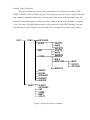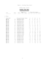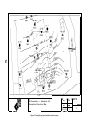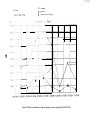
1
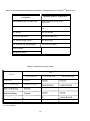
create a text file. For example, if two wells are named “LF-MW-06A” and “LF-MW-068” (nine-character
M will create only a single DOS name “LF-MW-06.MAT” to store the textual
names), then GIS\KeyTM
material descriptions for both wells. Separate text files cannot be created for these example wells. Acceptable well-naming conditions are discussed in the User Guide.
Chemical Data Entry
GIS\KeyTM provides data entry screens for several categories of chemical information. These
categories include the following:
Primarv Results: Laboratory results from the analysis of field samples. Primary results
are used to characterize site conditions.
QC Results: Laboratory results from the analysis of blanks, control standards, duplicates,
spikes, and surrogates. QC results are used to assess the performance of the laboratory
and field procedures.
Field Measurements: Results from the field measurements of parameters such as temperature, pH, turbidity, and purge volume. Field measurements provide supplemental
characterization of site conditions.
Several codes, which were discussed previously in Subsection 2.3.1, must be defined by the user
M uses these codes to organize or group related data and
before chemical data can be entered. GIS\KeyTM
to simplify data entry.
GIS\KeyTM enforces database integrity for the entry of certain data elements by accepting only
M does not check the validity of all data input. Details
valid or predefined values. However, GIS\Key TM
regarding input data validity checks are provided below for each category of chemical information.
Primary Results
Two preliminary data entry screens must be completed before the user is able to enter actual
chemical data. These preliminary screens require entry of sample description information, including
sampling locations and dates. Data entry and input validation findings for these initial screens are
described below.
.
GIS\KeyTM enforces the requirement that primary results can be entered for only
existing sample locations. However, it does not require that sample type correspond to sample location type. For example, GIS\KeyTM will not allow the user
to enter primary water sample results for a well that does not exist, but has the
31