1
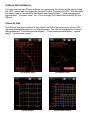
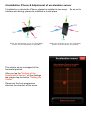
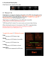
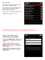
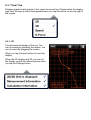
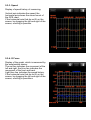
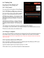
Street Capture for iPhone User's Manual
2009/11/20 Rev 1.0
Looped Picture Company
2-2-1 Otemachi Chiyoda-ku
Tokyo Japan
1. Notes
- This application uses the GPS & Accelerometer of the iPhone. We have developed
to be able to record the exact information, but may not be able to record the data by
the environment.
- Developer and manufacturer of this Software does not make any guarantee. Claim
can not be done at all. Please use at your own risk all.
- Please use in accordance with the laws of the country to take advantage of this
application. (Road Traffi c Law, e.t.c)
- This application has been tested in Japan. In places where GPS does not work
properly, StreetCapture does not work.
- The car of glass that can not receive the GPS, is not available.
- Trademark that is described in this manual, is a thing of the manufacturers that
have registered as a trademark.
- This software can not be transferred and resale.
When using this software, You will be able to agreed the contents of the above.
Looped Picture Company
2.About StreetCapture
You can now use the iPhone software for measuring the driving of the car by using
the GPS, which was developed by Looped Picture Company in 2003. This software
has been used to "automobile developer and manufacturer", "road management
organization", "Amateur race", etc. You can enjoy the StreetCapture easily By the
iPhone.
3.How to Use
The iPhone that was installed in the vehicle, save the Measure result of the GPS
data and acceleration sensor by StreetCapture. You can be displayed in 4 format
data measured. "Two-dimensional display", "Three-dimensional display", "speed
graph", "acceleration graph".
2D Graphic View
3D Graphic View
Speed Graph
Acceleration Graph
4.Installation iPhone & Adjustment of acceleration sensor
If installed in a vehicle the iPhone, please be installed in two ways. So as not to
interfere with driving, please be installed in a safe place.
When you horizontally set up the main body
(Please install horizontally as possible)
The vehicle set up is stopped at the
horizontal position.
After you tap the "Setting of the
Acceleration Sensor" on the Settings
tab, please tap the button "Setting the
Center".
Please set the front progression
direction the direction of the arrow.
When you vertically set up the main body
(Please install vertically as possible)
5. Functional Description
StreetCapture are consists of fi ve tabs.
5-1. "Measure" tab
StreetCapture is measured. Displays information of the GPS, the information of the
acceleration sensor.When displayed as "GPS can be measured" in "GPS status",
you can record the acceleration data and GPS data. "Long/Lat Accuracy" &
"Altitude Accuracy" will be displayed in 5 rank.
"Start" button is enabled Measure of the GPS data is possible.
# StreetCapture can not be measured before purchase.
"GPS Record Point" unless 10 or more counts, you can not save the log.
When detecting the amount of movement of the GPS, is appended data.
# During measurement, power saving function of the iPhone is turned off.
# Record the data of up to 28800 points in a log.
"Long/Lat Accuracy" & "Altitude Accuracy"
High:
Accuracy of GPS data is high
Middle:
Accuracy of GPS data in the middle
Low:
Accuracy of GPS data is low
Lowest:
Accuracy of GPS data is at least
Impossible:
Can not be measured the GPS data
5-2. "Log" tab
Here is a list of the log measure. Data is
read, when you tap the log list.
The "Connect" button is used when you
want to transmit and receive log in
BlueTooth to other iPhone.
"Edit" button is "Sort" and "Delete" of log.
Loaded log is shown in orange.
# The StreetCapture before purchasing, you can not log transfer by BlueTooth.
# The StreetCapture before purchasing, you will not be able to "Sort" and "Delete" of log.
When you tap the button on the
accessories list of the log, detailed
information in the log is displayed.
You can set "Model name", "Driver" and
"Comment" only log data that you have
saved.
When you tap the button "set as the
default information", and a current
"Model name", "Driver" is registered the
default settings.
If you do this, when a new log is saved,
"Model name" and "Driver" will be set
automatically.
5-3. "View" tab
Displays graphics and graphs of four types the saved log. Please select the display
type from the pop-up menu that appears when you tap the button on the top right of
the screen.
5-3-1. 2D
Two-dimensional display of the log. You
can do scaling by pinching the screen. You
can do move by dragging the screen.
When you tap the reset button to reset the
display.
When the 3D display and 2D, you can do
the display control the following three when
you tap the Settings button.
5-3-2. 3D
Three-dimensional display of the log. You
can do scaling by pinching the screen.
By selecting "Rotate" and "Move" button, it
works as follows.
- Rotate
You can do Rotate by dragging the screen.
- Move
You can do move by dragging the screen.
When you tap the reset button to reset the
display.
For the sake of clarity the difference in
height between three-dimensional display,
You can to scale the height difference.
When you select a "x1", it is displayed by
not scale the log data.You can specify the
altitude scale "x2-x10".
When you select a "x0", it is displayed with
altitude information of the sphere surface
without reference to the altitude
information.
The meaning of the display contents(2D/3D Common)
Red point : The point where the GPS-measured
Green point : measured starting point.
Purple point : measured end point.
Yellow point : 50 points each from the measured starting point.
Measurement information (upper left)
Sample Count : Available data count /Count data of measurement
Start Time : measure start time
End Time : Measurement end time
Interval Time : Recording time
Calculation information (lower left)
Vertical interval : Difference from minimum to maximum of altitude
Mileage : Distance in measure between
Max speed : Maximum speed of measure data
Ave speed : Average speed of measure data
5-3-3. Speed
Display of speed history of measuring.
Vertical axis indicates the speed, the
horizontal axis shows the record count of
the GPS chart.
If the horizontal axis that do not fi t on the
screen, by dragging the left and right of the
screen, scrolling is possible.
5-3-4. G Force
Display of the graph, which is measured by
the acceleration sensor.
The red line indicates the movement of the
left and right, the blue line indicates the
movement of the front and back.
Light blue line indicates the speed history.
If the horizontal axis that do not fi t on the
screen, by dragging the left and right of the
screen, scrolling is possible.a
5-4. "Setting" tab
You can do various settings for the
StreetCapture in the Settings tab.
5-4-1. Unit of speed
You can set the unit system in StreetCapture.
5-4-2. GPS Minimum/Maximum distance
You can set the value of the order to remove
the error in the measurement by the GPS.
GPS Minimum distance : If it is shorter than
the distance that the specifi ed distance of the
GPS data continuous measure, to exclude
the data.
GPS Maximum distance : If longer than the
distance that the specifi ed distance of GPS
continuous data measure, I will exclude the
data.
This distance can affect the maximum speed that can be measure.
For example, if you set the 55m, up to about 200km/h is not determined as an error.
Please set in the meter unit numbers of all.
5-4-3. Range of Judgment
You can set the distance to determine as a Lap point from the measurement point in
the closed course, such as a racing circuit. Please set in the meter unit numbers.
# Can not be determined that it is appropriate value. Please set a distance of about two times the
width of the road.
5-4-4. Lap time measurement GPS point
Set or the slider to determine as lap time measure point the difference GPS count
how much from start of measurement point.
Lap time measure point count can be set from 1 to 300.
If the value is zero, you will see all points of data measured.
5-5. "StreetCapture" tab
Simple description of StreetCapture, and, you
purchase StreetCapture of in the AppStore.
When you purchase the StreetCapture, you
can do measure, data transfer between the
iPhone by BlueTooth, log editing.
The
purchase
of
StreetCapture
communication with the AppStore is required.
If it is not a state that can be connected to the
network iPhone, you will not be able to tap
the purchase button.
# When you purchase, please tap the
purchase button at the communication state
is good.
5-6. Lap measure mode
If you want to display the data you recorded in closed-course, such as racing circuit,
If non-zero, lap time display is from the log that records the contents of the "5-4-4.
Lap time measurement GPS point".
If non-zero
# If you can not determine the orbit in the closed course, it does not Lap to measure mode.
Current View lap Number
When you change the number of laps, you
can switch around at Lap button in the
graphic part of the Two/Three-dimensional
display mode.
When you change the number of laps, it is
refl ected "speed" to "G Force" graph
display.
The judgment of the number of laps Lap
measure mode, please adjust the settings
of "5-4-4. Lap time measurement GPS
point".
Up to 32 Lap up, judgment possible.
Total number of laps that were analyzed
5-7. Data transfer to other iPhone by BlueTooth
Please prepare two the iPhone that was
purchased StreetCapture.
After starting StreetCapture the iPhone
two, select the Logs tab.
Tap the "Connect" button on the iPhone
two, and then BlueTooth communication
state the iPhone.
5-7-1. Transmission of log data
The transmission of the log, it is possible to
more information from the log screen that
appears when you tap the accessory button
on the log list
# You can transfer only log as measured by yourself.
Log is sent start, iPhone one will receive
more.
When BlueTooth communication state, you
can send and receive at any time.
5-7-2. Receive of log data
When the iPhone is connected've been
sending the log, it is stored in the
StreetCapture automatically.
Log is received successfully, appears the
name of the log that is received by the alert
screen.
When BlueTooth communication state, you
can send and receive at any time.
Log transmission button
5-8. Tips
Introducing the tips of StreetCapture
- Please set to "On", "Wi-Fi" from the "Settings" when making the measure.
(It is OK if you do not connect to a wireless LAN)
- Please set to "Off" BlueTooth.
- When performing the installation in a vehicle, to be placed in the state of either
horizontal or vertical.
(Acceleration sensor can not determine normally close to a 45-degree angle.)
- GPS models of iPhone4s later because it supports the "GLONASS", you can GPS
measurement more accurate.
- During measurement, please state to charge the iPhone if possible.
(Please use a USB adapter and cigarette lighter socket of the car.)