1
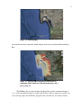
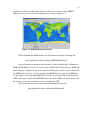
DEVELOPING A NESTED HYDRODYNAMICAL MODEL
FOR SAN DIEGO BAY, CA
USING DELFT3D AND DELFTDASHBOARD
A Thesis
Presented to the
Faculty of
San Diego State University
In Partial Fulfillment
of the Requirements for the Degree
Master of Science
in
Computational Science
by
Mohammad Abouali
Spring 2013
iii
c 2013
Copyright by
Mohammad Abouali
All Rights Reserved
iv
DEDICATION
To The San Diego Community
v
The illiterate of the 21st century will not be those who cannot read and write, but those
who cannot learn, unlearn, and relearn.
– Alvin Toffler
vi
ABSTRACT OF THE THESIS
Developing a Nested Hydrodynamical Model
for San Diego Bay, CA
Using Delft3D and DelftDashboard
by
Mohammad Abouali
Master of Science in Computational Science
San Diego State University, 2013
In this project, three hydrodynamic models of the San Diego Bay were developed. The
first one was a coarse model (2.5 km resolution) covering all of Southern California. This
model affords valuable data for areas close to San Diego Bay, but is not capable of providing
any information from within the bay itself. The second model is a standalone, high-resolution
(50 m) hydrodynamic model that is capable of simulating the hydrodynamics within the bay.
However, this model is unaffected by the information from outside of the actual bay. The third
is a multi-domain model of the San Diego Bay, which is a high-resolution model nested
within the coarser model of Southern California. This model is capable of simulating the
hydrodynamics within the bay, and enables the study of the impact of events originating well
outside of the San Diego region; hence, it offers broader capabilities and applications.
All three of these models can be used to study the San Diego Bay’s ecology, including
the effect of toxic pollutants and the overall water quality in the region. Considering the fact
that the San Diego Bay is extremely important to both the economy and ecology of the region,
and taking into account that the models developed here are based on free source code
(Delft3D) and freely available data sets (making the operation costs very low), it becomes
fairly certain that researchers, scientists, and institutions could benefit from the models
developed in this project. As a result, this model could help the San Diego community better
understand the local environment, thereby enabling it to make better, more informed decisions
regarding projects affecting the ecology of the region.
vii
TABLE OF CONTENTS
PAGE
ABSTRACT . . . . . . . . . . . . . . . . . . . . . . . . . . . . . . . . . . . . . . . . . . . . . . . . . . . . . . . . . . . . . . . . . . . . . . . . . . . . . . . . . . . .
vi
LIST OF FIGURES . . . . . . . . . . . . . . . . . . . . . . . . . . . . . . . . . . . . . . . . . . . . . . . . . . . . . . . . . . . . . . . . . . . . . . . . . . . .
ix
ACKNOWLEDGMENTS . . . . . . . . . . . . . . . . . . . . . . . . . . . . . . . . . . . . . . . . . . . . . . . . . . . . . . . . . . . . . . . . . . . . .
xi
CHAPTER
1
2
INTRODUCTION . . . . . . . . . . . . . . . . . . . . . . . . . . . . . . . . . . . . . . . . . . . . . . . . . . . . . . . . . . . . . . . . . . . . .
1
1.1
Motivation . . . . . . . . . . . . . . . . . . . . . . . . . . . . . . . . . . . . . . . . . . . . . . . . . . . . . . . . . . . . . . . . . . . . . . .
2
1.2
Study Area . . . . . . . . . . . . . . . . . . . . . . . . . . . . . . . . . . . . . . . . . . . . . . . . . . . . . . . . . . . . . . . . . . . . . . .
3
DELFT3D MODEL DESCRIPTION . . . . . . . . . . . . . . . . . . . . . . . . . . . . . . . . . . . . . . . . . . . . . . . . .
6
2.1
6
2.2
2.3
3
Delft3D Grid and Coordinate System . . . . . . . . . . . . . . . . . . . . . . . . . . . . . . . . . . . . . . . . . .
2.1.1
Horizontal Grid . . . . . . . . . . . . . . . . . . . . . . . . . . . . . . . . . . . . . . . . . . . . . . . . . . . . . . . . . . . .
6
2.1.2
Vertical Grid . . . . . . . . . . . . . . . . . . . . . . . . . . . . . . . . . . . . . . . . . . . . . . . . . . . . . . . . . . . . . . .
7
2.1.3
Staggered Grid . . . . . . . . . . . . . . . . . . . . . . . . . . . . . . . . . . . . . . . . . . . . . . . . . . . . . . . . . . . . .
8
Governing Equations . . . . . . . . . . . . . . . . . . . . . . . . . . . . . . . . . . . . . . . . . . . . . . . . . . . . . . . . . . . .
9
2.2.1
Continuity Equation . . . . . . . . . . . . . . . . . . . . . . . . . . . . . . . . . . . . . . . . . . . . . . . . . . . . . . .
9
2.2.2
Momentum Equation in Horizontal Direction. . . . . . . . . . . . . . . . . . . . . . . . . . . . 10
2.2.3
Vertical Velocity . . . . . . . . . . . . . . . . . . . . . . . . . . . . . . . . . . . . . . . . . . . . . . . . . . . . . . . . . . . 10
2.2.4
Hydrostatic Pressure . . . . . . . . . . . . . . . . . . . . . . . . . . . . . . . . . . . . . . . . . . . . . . . . . . . . . . . 11
2.2.5
Horizontal Stresses . . . . . . . . . . . . . . . . . . . . . . . . . . . . . . . . . . . . . . . . . . . . . . . . . . . . . . . . 11
2.2.6
Equation of State . . . . . . . . . . . . . . . . . . . . . . . . . . . . . . . . . . . . . . . . . . . . . . . . . . . . . . . . . . 11
2.2.7
Bed Shear Stress . . . . . . . . . . . . . . . . . . . . . . . . . . . . . . . . . . . . . . . . . . . . . . . . . . . . . . . . . . . 12
Time and Spatial Discretization . . . . . . . . . . . . . . . . . . . . . . . . . . . . . . . . . . . . . . . . . . . . . . . . 13
INSTALLATION. . . . . . . . . . . . . . . . . . . . . . . . . . . . . . . . . . . . . . . . . . . . . . . . . . . . . . . . . . . . . . . . . . . . . . . 14
3.1
3.2
Delft3D . . . . . . . . . . . . . . . . . . . . . . . . . . . . . . . . . . . . . . . . . . . . . . . . . . . . . . . . . . . . . . . . . . . . . . . . . . 14
3.1.1
Obtaining the Source Code. . . . . . . . . . . . . . . . . . . . . . . . . . . . . . . . . . . . . . . . . . . . . . . . 15
3.1.2
Compiling Delft3D . . . . . . . . . . . . . . . . . . . . . . . . . . . . . . . . . . . . . . . . . . . . . . . . . . . . . . . . 16
3.1.3
Testing Delft3D . . . . . . . . . . . . . . . . . . . . . . . . . . . . . . . . . . . . . . . . . . . . . . . . . . . . . . . . . . . . 17
3.1.4
Delft3D GUI . . . . . . . . . . . . . . . . . . . . . . . . . . . . . . . . . . . . . . . . . . . . . . . . . . . . . . . . . . . . . . . 17
Delft Dashboard . . . . . . . . . . . . . . . . . . . . . . . . . . . . . . . . . . . . . . . . . . . . . . . . . . . . . . . . . . . . . . . . . 18
viii
4
SINGLE DOMAIN SAN DIEGO MODEL . . . . . . . . . . . . . . . . . . . . . . . . . . . . . . . . . . . . . . . . . . 20
4.1
4.2
5
6
2.5 km Resolution Southern California Model . . . . . . . . . . . . . . . . . . . . . . . . . . . . . . . . 20
4.1.1
Model Setup . . . . . . . . . . . . . . . . . . . . . . . . . . . . . . . . . . . . . . . . . . . . . . . . . . . . . . . . . . . . . . . 20
4.1.2
Model Results. . . . . . . . . . . . . . . . . . . . . . . . . . . . . . . . . . . . . . . . . . . . . . . . . . . . . . . . . . . . . . 22
50 m Resolution San Diego Bay Model . . . . . . . . . . . . . . . . . . . . . . . . . . . . . . . . . . . . . . . . 28
4.2.1
Model Setup . . . . . . . . . . . . . . . . . . . . . . . . . . . . . . . . . . . . . . . . . . . . . . . . . . . . . . . . . . . . . . . 28
4.2.2
Model Results. . . . . . . . . . . . . . . . . . . . . . . . . . . . . . . . . . . . . . . . . . . . . . . . . . . . . . . . . . . . . . 29
NESTED SAN DIEGO BAY MODEL . . . . . . . . . . . . . . . . . . . . . . . . . . . . . . . . . . . . . . . . . . . . . . . 31
5.1
Model Setup . . . . . . . . . . . . . . . . . . . . . . . . . . . . . . . . . . . . . . . . . . . . . . . . . . . . . . . . . . . . . . . . . . . . . 31
5.2
Model Results . . . . . . . . . . . . . . . . . . . . . . . . . . . . . . . . . . . . . . . . . . . . . . . . . . . . . . . . . . . . . . . . . . . 32
CONCLUSION AND POSSIBLE FUTURE WORKS . . . . . . . . . . . . . . . . . . . . . . . . . . . . . . 34
BIBLIOGRAPHY . . . . . . . . . . . . . . . . . . . . . . . . . . . . . . . . . . . . . . . . . . . . . . . . . . . . . . . . . . . . . . . . . . . . . . . . . . . . . . 36
ix
LIST OF FIGURES
PAGE
Figure 1.1. Southern California. . . . . . . . . . . . . . . . . . . . . . . . . . . . . . . . . . . . . . . . . . . . . . . . . . . . . . . . . . . . . . .
3
Figure 1.2. San Diego Bay. . . . . . . . . . . . . . . . . . . . . . . . . . . . . . . . . . . . . . . . . . . . . . . . . . . . . . . . . . . . . . . . . . . .
4
Figure 1.3. San Diego Bay bathymetry constructed by combining USGS Southern California bathymetry and a private data set. . . . . . . . . . . . . . . . . . . . . . . . . . . . . . . . . . . . .
4
Figure 1.4. Approximate outline of the detailed San Diego Bay model (red line)
nested inside the coarse Southern California model (yellow boundary). . . . . . . . . . . .
5
Figure 2.1. An orthogonal curvilinear grid. Each element is addressed with
a pair of (ξ, η) coordinates. source: Delft3D Example #1 - Deltares,
Delft3D-FLOW User Manual. . . . . . . . . . . . . . . . . . . . . . . . . . . . . . . . . . . . . . . . . . . . . . . . . . . . . . . . . .
7
Figure 2.2. Vertical Grid: Sigma Coordinate (left) and Z-Level (right). Source:
Deltares, Delft3D-FLOW user manual, Delft, the Netherlands, 2011. . . . . . . . . . . . . .
7
Figure 2.3. Staggered grid used in Delft3D. Source: Deltares, Delft3D-FLOW
user manual, Delft, the Netherlands, 2011. . . . . . . . . . . . . . . . . . . . . . . . . . . . . . . . . . . . . . . . . . .
9
Figure 3.1. DelftDashboard screen shot. . . . . . . . . . . . . . . . . . . . . . . . . . . . . . . . . . . . . . . . . . . . . . . . . . . . . . 19
Figure 4.1. Southern California coarse model and control stations. The blue
line shows the location of the open boundary. . . . . . . . . . . . . . . . . . . . . . . . . . . . . . . . . . . . . . . . 21
Figure 4.2. Changes in the water level at the La Jolla station. Delft3D output
(blue line) and station value (red line). . . . . . . . . . . . . . . . . . . . . . . . . . . . . . . . . . . . . . . . . . . . . . . . 23
Figure 4.3. Changes in the water level at the Long Beach station. Delft3D
output (blue line) and station value (red line). . . . . . . . . . . . . . . . . . . . . . . . . . . . . . . . . . . . . . . . 23
Figure 4.4. Changes in the water level at the Los Angeles station. Delft3D
output (blue line) and station value (red line). . . . . . . . . . . . . . . . . . . . . . . . . . . . . . . . . . . . . . . . 24
Figure 4.5. Changes in the water level at the Newport station. Delft3D output
(blue line) and station value (red line). . . . . . . . . . . . . . . . . . . . . . . . . . . . . . . . . . . . . . . . . . . . . . . . . 24
Figure 4.6. Changes in the water level at the Santa Barbara station. Delft3D
output (blue line) and station value (red line). . . . . . . . . . . . . . . . . . . . . . . . . . . . . . . . . . . . . . . . 25
Figure 4.7. Velocity vectors in Southern California coarse model on Feb. 1,
2008 at 00:00. . . . . . . . . . . . . . . . . . . . . . . . . . . . . . . . . . . . . . . . . . . . . . . . . . . . . . . . . . . . . . . . . . . . . . . . . . 26
Figure 4.8. Velocity vectors in Southern California coarse model on Feb. 1,
2008 at 06:00. . . . . . . . . . . . . . . . . . . . . . . . . . . . . . . . . . . . . . . . . . . . . . . . . . . . . . . . . . . . . . . . . . . . . . . . . . 26
Figure 4.9. Velocity vectors in Southern California coarse model on Feb. 1,
2008 at 12:00. . . . . . . . . . . . . . . . . . . . . . . . . . . . . . . . . . . . . . . . . . . . . . . . . . . . . . . . . . . . . . . . . . . . . . . . . . 27
x
Figure 4.10. Velocity vectors in Southern California coarse model on Feb. 1,
2008 at 18:00. . . . . . . . . . . . . . . . . . . . . . . . . . . . . . . . . . . . . . . . . . . . . . . . . . . . . . . . . . . . . . . . . . . . . . . . . . 27
Figure 4.11. High-resolution San Diego Bay model. . . . . . . . . . . . . . . . . . . . . . . . . . . . . . . . . . . . . . . . . 28
Figure 4.12. Changes in the water level during the first day of simulation.
Delft3D output (blue line) and station value (red line). . . . . . . . . . . . . . . . . . . . . . . . . . . . . . 29
Figure 4.13. Velocity vectors in high-resolution San Diego Bay Model. . . . . . . . . . . . . . . . . . . . 30
Figure 5.1. Changes in the water level at the San Diego bay station for the nested
model during the first two days of the simulation. Delft3D output (blue
line) and station value (red line). . . . . . . . . . . . . . . . . . . . . . . . . . . . . . . . . . . . . . . . . . . . . . . . . . . . . . 32
Figure 5.2. Changes in the water level at the San Diego Bay station. Nested San
Diego Bay model (blue line) and single domain San Diego Bay model
(dashed red line). . . . . . . . . . . . . . . . . . . . . . . . . . . . . . . . . . . . . . . . . . . . . . . . . . . . . . . . . . . . . . . . . . . . . . . 33
Figure 6.1. The San Diego Bay’s entrance and structures protecting the bay. . . . . . . . . . . . . . . 35
xi
ACKNOWLEDGMENTS
The best is usually kept for the last; and perhaps that’s the reason that the
”acknowledgements” is the last part that gets written in any thesis. I enjoy writing the
”acknowledgments”; not just because I get a chance to thank people who helped me to
succeed; but also because it makes me to sit back, relax for a while, and review the wonderful
and amazing memories and moments that I had with them. Life, particularly nowadays, goes
very fast. However, joy, beauty, love, and the good memories are ”hidden away between the
seconds of your life. If you don’t stop for a minute, you might miss it.” (Cashback, the movie,
2006).
Despite spending a very short time to prepare this thesis, there are many people whose
assistance and help were absolutely necessary to make this thesis and project successful. First
of all I want to thank my supervisor Prof. Jose E. Castillo, who let me to take some time off of
my Ph.D. project to complete this project and obtain a second Master of Science (MS) degree.
I cannot thank him enough for his assistance in this project. I want to thank my thesis
committee, Prof. Peter Blomgren and Prof. Barbara Bailey, to share their time, particularly so
close to the end of the year, and their inputs to make this thesis even better. I want to thank
Jessica Nombrano for proof reading my thesis and the wonderful job she did. I want to thank
Parisa Plant for taking care of the paper work, administration, and ordering all the computer
hardware and software that I needed for this project. I also want to thank all my friends for
their support and the good time we had. Particularly, I want to thank Sara and Ali for all the
time we spend together and all the nights that we were staying up late working on our projects.
I also want to thank my parents, Parvin Arvaneh and Hossein Abouali, for their
unconditional love. Despite being physically far away, they kept encouraging me to invest in
higher educations. They have devoted their life to their children and there is no word to thank
them properly. I also want to thank my sister, Azadeh Abouali, for her support even from the
far distance. The last but not the least, I want to thank my girlfriend, Golnaz Badr, for her
endless love and enduring support. She does a wonderful job in motivating me to proceed and
advance in my life. I want to thank her for standing by me and helping me through life.
1
CHAPTER 1
INTRODUCTION
San Diego Bay, like all bays, provides dual usage for both commercial shipping and
recreational activities. San Diego Bay is also the home of one of the largest naval bases in the
United States, and a significant number of military activities occur there, including training of
the US Navy SEALs (SEa, Air, Land teams). Many changes have been made to the bay since
1962, when the Port of San Diego was established to make more land available for
commercial and recreational activities. For example, most of the available marshland, and
more than half of all intertidal lands were reclaimed by 1975 [30]. Since the establishment of
the Port of San Diego, the region has grown extensively, adding facilities such as a landmark
convention center, luxury hotels, parks, and cruise and cargo terminals.
Such diverse activities do not necessarily work in favor of the region’s ecology. One
example being that the southern part of the San Diego Bay is covered with eelgrass, which is
considered to be a very valuable shallow-water habitat that provides numerous ecological
services, such as shelter, nutrient cycling, a breeding habitat for various species, stabilizing
sediments, and important organic material for near-shore environments. Eelgrass requires
special conditions to flourish, and is sensitive to tidal changes in the bay [13].
However, because of the extensive human activities in the region, many parts of the
bay have become impaired by the presence of toxic metals and organic pollutants [39]. As a
result, many institutes, organizations, and corporations are performing water quality studies in
the region in order to enhance the water quality and save the natural habitat of various local
birds and sea life [13, 39].
A numerical model is perhaps the best method available for use in understanding the
region, and for modeling the quality of the water [39]. However, most biological and water
quality models require a detailed hydrodynamic model of the region [31, 39]. Information
about the hydrodynamics of a region, including knowledge of the velocity, water level, and
fluxes at every grid cell, enables the researcher to perform a quantitative analysis of the water
quality, and provides an understanding of the behavior of the environment, including
determining the fate of different chemical compounds [8, 17, 18, 26, 27, 29].
As a result of its environmental and economic importance, there are numerous
hydrodynamic studies currently underway in the region. Many measurements and
experimental studies have taken place in San Diego Bay [45], including Wang’s numerical
hydrodynamic study dating back to 1998 [45]. Wang used a numerical grid with a 100 m
2
spatial resolution, and was able to simulate tidal water levels within an acceptable range of
errors. Since then, many more numerical models have been developed, most of which have
been funded or performed by the US Navy. One of the most detailed studies of the bay is that
performed by the Environmental Security Technology Certification Program (ESTCP) [7].
However, the project’s demonstration cost alone was approximately $580,000, which is a
quarter of a million dollars more than the CH3D base model ($329,106) [7].
The majority of San Diego Bay models have either been based on curvilinear-grid
hydrodynamics 3D (CH3D) or environmental fluid dynamic code (EFDC); however, almost
all of them share the same CH3D grid that was originally developed by the Navy for studies
of the San Diego Bay. The grid size in these models is, on average, 100 m, with a maximum
of 250 m and a minimum of slightly more than 18 m [39]. Although the minimum grid length
is reported to be 18 m, it should be noted that this only applies to one direction of the grid
cells, and in those regions the cells are elongated in the opposite direction.
1.1 M OTIVATION
Due to the importance of the San Diego Bay and the vital role it plays in the local
economy, it was decided to develop a high-resolution hydrodynamic model for the region. As
described earlier, the outputs of the previous hydrodynamic models have played a vital role in
other studies, including biogeochemical, habitat and ecological modeling studies. Numerous
studies have already been performed in the region, and a few were mentioned in the previous
section. However, despite many successful modeling efforts made in the past, the grid
resolution of these models varies within the bay, and does not provide the same high
resolution for the entire area.
Since having a high-resolution hydrodynamic model is vital for water quality and
other environmental studies, it was decided to develop a high-resolution model for the San
Diego Bay that would provide consistent resolution over the entire bay. As some of the past
efforts have proven to be very costly (over half a million dollars) [7], our goal is to use free
and open source software that can be executed on a regular desktop computer, and yet is still
able to provide a consistently high-resolution model of the entire bay.
It was also decided to provide a model that is capable of creating a wetting and drying
scheme. Although some of the past modeling efforts were capable of wetting and drying, a
curvilinear grid was used, and only a narrow strip around the shoreline was included. The
model developed for this project covers the entirety of Coronado Island, and is capable of
performing both wetting and drying. (Only regions with a ground elevation exceeding 20 m
were set as always dry.)
3
1.2 S TUDY A REA
The study area in this project is limited to Southern California (Figure 1.1) and the San
Diego Bay. San Diego Bay is located at roughly ”32◦ 390 5700 N ” and ”117◦ 80 2200 W .” It is
approximately 17 km long, with a maximum curved path of roughly 22 km. The width of the
bay varies; its widest part is approximately 3.7 km, and it narrows down in the middle to
0.7 km. The San Diego Bay’s mouth is about 1.8 km wide, shrinking immediately down to
about 0.6 km (Figure 1.2).
Figure 1.1. Southern California.
The first item needed to create any ocean model is the bathymetry. Depending on the
resolution of the model, the resolution of the bathymetry data set can also change. There was
no public data set available that included proper bathymetry information for the interior of the
San Diego Bay, as all public data sets were either too coarse to cover the bay, or the maximum
depth inside the bay was erroneously shown to be a mere 1 m. However, we were fortunate
enough to have access to high resolution bathymetry data of the interior of the bay, thanks to
the high-resolution bathymetry contour lines provided to us by the US Navy. Without this data
set, this project would have been impossible. The contour lines were interpolated using
ILWIS and ArcGIS software to a 5 m spatial resolution grid. Throughout this thesis we refer
to this data set as ’SDBathy.’ SDBathy was combined with the USGS’s Southern California
bathymetry using ArcGIS 9.3 software (SDSU License) (Figure 1.3). As can be seen in
Figure 1.3, the Navy’s data does not match the USGS data set at the entrance to the bay.
However, as this discrepancy did not appear to have much of an impact on the hydrodynamic
model, it was decided to take no action. (Later, it is shown that even with this discrepancy, our
4
Figure 1.2. San Diego Bay.
nested model was able to perfectly match changes in the water elevation within San Diego
Bay.)
Figure 1.3. San Diego Bay bathymetry constructed by
combining USGS Southern California bathymetry and a
private data set.
The SDBathy data set shows that the San Diego Bay reaches a maximum depth of
72 m. A clear navigation channel is visible inside the bay, which is designed to provide easy
access for large ships and submarines going into and out of the bay. At certain positions,
5
further unnatural bathymetry is seen; these positions are believed to be where submarines are
located. It should be noted that San Diego Bay is home to one of the largest naval bases in the
United States, and a significant amount of activity occurs there.
The goal here is to develop a high-resolution model of the San Diego Bay, nested
inside a model of Southern California using Delft3D. This model should be able to predict the
tidal wave and water level as precisely as possible. It should also be able to perform wet and
dry computations; i.e., depending on the depth of the water, it should be able to calculate what
part of the land is going to be underwater and what part will stay dry. Such schemes usually
introduce a significant number of oscillations (wiggles) in the water level calculations.
Therefore, we will also check if Delft3D is able to produce an oscillation-free solution.
Approximate boundaries for the larger Southern California model and the detailed model of
the San Diego Bay are shown in Figure 1.4. In later chapters, the full information for each
grid will be provided.
Figure 1.4. Approximate outline of the detailed San Diego Bay
model (red line) nested inside the coarse Southern California
model (yellow boundary).
6
CHAPTER 2
DELFT3D MODEL DESCRIPTION
This chapter is devoted to explaining the coordinate system, governing equations, and
numerical schemes used in the Delft3D model. This chapter only focuses on those aspects of
Delft3D that have been used in this project; however, Delft3D is a very comprehensive model
and includes many modules and features for use in different modeling scenarios and hydraulic
structures. For a full description of the model, refer to the Delft3D Flow User Manual [10].
2.1 D ELFT 3D G RID AND C OORDINATE S YSTEM
One must first select a coordinate system in order to represent a physical space or
domain. There are many choices available; ocean modeling usually requires one approach to
represent the horizontal direction, and another to represent the vertical direction. The
horizontal grid can affect the stability of the numerical scheme and how well the lateral
boundaries are represented. However, the vertical boundary is also very important, as most of
the parameterizations of the model are affected by the choice of vertical grid [2]. In this
section, the different choices available in Delft3D for coordinate systems are discussed.
2.1.1 Horizontal Grid
In general, for the horizontal direction, Delft3D supports an orthogonal curvilinear
coordinate system. Two options are available:
• Cartesian coordinates (ξ, η), (Figure 2.1)
• Spherical coordinates (λ, φ).
Rectangular and rectilinear grids are considered special cases of Cartesian
coordinates. In Cartesian coordinates, the top lid of the domain is considered to be flat. In
spherical coordinates λ is the longitude and φ is the latitude. In this coordinate, the top lid of
the model follows the Earth’s curvature. Spherical coordinates are also a special case of the
orthogonal curvilinear grid, where:
ξ = λ
η = φ
p
Gξξ = R cos φ
p
Gηη = R
(2.1)
7
p
p
where R = 6378.137 km is the Earth’s radius, Gξξ , and Gηη are coefficients used to
transform curvilinear coordinates into a rectangular grid.
Figure 2.1. An orthogonal curvilinear grid. Each element is
addressed with a pair of (ξ, η) coordinates. source: Delft3D
Example #1 - Deltares, Delft3D-FLOW User Manual.
2.1.2 Vertical Grid
In the vertical direction, Delft3D offers two coordinate options, Figure 2.2, as follows:
• σ coordinate system (Sigma Coordinate),
• Z-Model or Z-Level.
Figure 2.2. Vertical Grid: Sigma Coordinate (left) and Z-Level
(right). Source: Deltares, Delft3D-FLOW user manual, Delft,
the Netherlands, 2011.
8
Figure 2.2 illustrates how these two grids are different. The sigma coordinate was
originally developed by Phillips [32], and is designed in such a way that σ = −1 at the bottom
and σ = 0 at the free surface. The transformation from a physical z-coordinate to σ
coordinates is done as follows:
σ=
z−ζ
,
d+ζ
(2.2)
where:
• ζ is the free surface elevation above the reference plane.
• d is the the depth below the reference plane.
It should be noted that the sigma coordinate was originally developed for slopes up to
45 [19, 20]. Slopes steeper than that will produce numerical errors, and it has been shown
that over very steep slopes, sigma-coordinates produce poor results [1, 5, 15, 16, 28]. Partial
derivatives can be calculated using the chain rule of derivation, which will then introduce
some additional terms [1, 38].
In coastal seas, estuaries, lakes, and generally in places where there is steep
topography or bathymetry, the sigma coordinate can produce numerical errors. The slope is
also a function of the horizontal grid resolution. In coarse resolutions, the bottom bathymetry
is represented smoothly, and most of the high-frequency variations in the bathymetry are
filtered out [1]. The sigma coordinate, despite being a boundary-fitted coordinate, does not
necessarily have enough resolution around the pycnocline [23, 25, 38]. One approach to
overcoming this issue is to use curvilinear coordinates in the vertical direction [1]. Another
common approach, which is also supported by Delft3D, is to use the Z-level (Z-grid) in the
vertical direction. In the Z-grid, the horizontal lines nearly match those of the isopycnal’s
lines; i.e., they are parallel to the density interfaces.
◦
2.1.3 Staggered Grid
In any hydrodynamic model, including in Delft3D, there are several variables that are
simulated, including three components of the velocity, the pressure, salinity, and temperature.
In general, they can be divided into vector variables, such as velocity; and scalar variables,
such as pressure, salinity, and temperature. Depending on how these different variables are
arranged in a grid, one can have different grid types, known as type A, B, C, D, and E [15].
Delft3D uses a C-grid, also known as a staggered grid (Figure 2.3). In a staggered grid, the
scalar values are stored at the cell center, and different components of the vector variables
(usually the velocity) are stored at the middle of the cell faces.
9
Figure 2.3. Staggered grid used in Delft3D. Source: Deltares,
Delft3D-FLOW user manual, Delft, the Netherlands, 2011.
2.2 G OVERNING E QUATIONS
Delft3D uses nonlinear shallow water equations in 2D and 3D. Shallow water
equations (SWE) are derived by averaging the full Navier-Stokes equation in the vertical
direction. Several assumptions have been made to derive these equations: the main
assumption is that the horizontal length scale is much larger than the vertical length scale.
This is normally true for any ocean flow model. However, this assumption practically reduces
the vertical momentum equation to a hydrostatic pressure equation. While this is a valid
assumption in coarse resolution, extra care must be taken in very fine resolution cases, as well
as those where fluid flow interaction with the bottom bathymetry is the dominant process [1].
In these regions, vertical velocity plays an important role in mixing, and even in the carrying
of the energy [1, 4, 9, 14, 21, 33, 40, 41, 42].
Despite some of the limitations of nonlinear shallow water equations, they can be still
used for many applications. In fact, the majority of ocean models currently available use this
set of equations. The following reviews only the most important set of equations in Delft3D,
which were used in this project. As mentioned before, Delft3D has many other modules and
capabilities. For further information, including the governing equations for those modules,
refer to the Delft3D Flow User Manual [10].
2.2.1 Continuity Equation
The depth-averaged continuity equation with source and sink terms in Delft3D is
written as follows:
p
p ∂ (d + ζ)U Gηη
∂ (d + ζ)V Gξξ
1
1
∂ζ
+p p
+p p
= Q,
∂t
∂ξ
∂η
Gξξ Gηη
Gξξ Gηη
where:
p
p
• Gξξ , and Gηη are coefficients used to transform curvilinear coordinates to
rectangular grid,
(2.3)
10
• U and V are the depth-integrated velocity in computational domain.
• Q is the source/sink term which is defined as follows:
Z 0
(qin − qout ) dσ + P − E.
Q=H
(2.4)
−1
In Equation 2.4, H = d + ζ, P is the precipitation, E is the evaporation, qin is any
source of water, and qout is any sink for water (such as an intake of power plant for its cooling
system).
2.2.2 Momentum Equation in Horizontal Direction
The momentum equation can be written as:
∂u
=
∂t
u ∂u
v ∂u
ω u
−p
−p
−
Gξξ ∂ξ
Gηη ∂η d + ζ ∂σ
p
p
∂ Gηη
∂ Gξξ
v2
uv
+p p
−p p
Gξξ Gηη ∂ξ
Gξξ Gηη ∂η
+f v + Fξ + Mξ
∂u
1
∂
1
Pξ +
νV
− p
(d + ζ)2 ∂σ
∂σ
ρ0 Gξξ
∂v
=
∂t
u ∂v
v ∂v
ω v
−p
−p
−
Gξξ ∂ξ
Gηη ∂η d + ζ ∂σ
p
p
∂ Gηη
∂ Gξξ
u2
uv
+p p
−p p
Gξξ Gηη ∂ξ
Gξξ Gηη ∂η
−f u + Fη + Mη
1
1
∂
∂v
− p
Pη +
νV
,
(d + ζ)2 ∂σ
∂σ
ρ0 Gηη
(2.5)
and
(2.6)
where u and v are the eastward and northward velocity in the physical domain, respectively;
νV is the vertical eddy viscosity coefficient [34]; Fξ and Fη represent the unbalance of the
horizontal Reynold’s stresses; Mξ and Mη represent the contribution due to external sources
or sinks; and f is the Coriolis coefficient.
2.2.3 Vertical Velocity
Remember that ω in Equations 2.5 and 2.6 is the vertical velocity relative to the sigma
Plane, and that it is not the vertical velocity in the physical domain. ω is calculated from the
11
continuity equation; the vertical physical velocity is calculated (only for post-processing
purposes), as follows:
w= ω+p
1
p
Gξξ
Gηη
p
p
∂H ∂ζ
∂H ∂ζ
+
+ v Gξξ σ
+
u Gηη σ
∂ξ
∂ξ
∂η
∂η
∂H
ζ
+ σ
+
.
∂t
∂t
(2.7)
2.2.4 Hydrostatic Pressure
Remember that in Equation 2.5 and 2.6, pressure is defined as hydrostatic pressure.
Therefore, in case of constant density, the pressure terms in the momentum equation are:
1
1
g ∂ζ
∂Patm
p
+ p
,
Pξ = p
ρ0 Gξξ
Gξξ ∂ξ ρ0 Gξξ ∂ξ
g ∂ζ
1
1
∂Patm
p
Pη = p
+ p
.
ρ0 Gηη
Gηη ∂η ρ0 Gηη ∂η
(2.8)
(2.9)
If the density is not constant, one gets:
1
p
Pη
ρ0 Gηη
0
∂ρ ∂ρ ∂σ
+
dσ 0 ,
∂ξ ∂σ ∂ξ
σ
Z 0
g ∂ζ
d+ζ
∂ρ ∂ρ ∂σ
= p
+g p
+
dσ 0 .
Gηη ∂η
ρ0 Gηη σ ∂η ∂σ ∂η
1
g ∂ζ
d+ζ
p
Pξ = p
+g p
ρ0 Gξξ
Gξξ ∂ξ
ρ0 Gξξ
Z
(2.10)
(2.11)
2.2.5 Horizontal Stresses
The horizontal stresses in the momentum equation can be reduced to a Laplace’s
operator [3, 6, 38] as follow:
!
Fξ = νH
1
∂ 2u
1
∂ 2u
p p
p
p
+
Gξξ Gηη ∂ξ 2
Gξξ Gηη ∂η 2
!
F η = νH
1
∂ 2v
1
∂ 2v
p p
p
p
+
Gξξ Gηη ∂ξ 2
Gξξ Gηη ∂η 2
,
(2.12)
.
(2.13)
2.2.6 Equation of State
The equation of state (EOS) determines the water density (ρ) as a function of the
salinity and Temperature, and features different formulations for seawater. Delft3D supports
both Eckart’s equation [12] and the UNESCO equation [43, 44]. Eckart’s equation has several
limitations; however, the UNESCO equation (also called EOS80) has proven to have better
12
performance (3.6 g/m3 error). Delft3D uses EOS80 by default; EOS80 can be written as
follows:
ρ = ρ0 + As + Bs(3/2) + Cs2 ,
(2.14)
where:
ρ0 =
999.842594 + 6.793952 · 10−2 t − 9.095290 · 10−3 t2
(2.15)
+1.001685 · 10−4 t3 − 1.120083 · 10−6 t4 + 6.536332 · 10−9 t5 ,
A=
8.24493 · 10−1 − 4.0899 · 10−3 t + 7.6438 · 10−5 t2
(2.16)
−8.2467 · 10−7 t3 + 5.3875 · 10−9 t4 ,
B=
−5.72466 · 10−3 + 1.0227 · 10−4 t − 1.6546 · 10−6 t2 ,
(2.17)
C=
4.8314 · 10−4 .
(2.18)
EOS80 is valid for t ∈ [0 ◦ C, 40 ◦ C] and s ∈ [0.5 ppt, 43 ppt], where ”ppt” stands for
”part per thousands”. It should be noted that, in the presence of other chemicals in the ocean
water, the above mentioned equation may no longer hold true.
2.2.7 Bed Shear Stress
Delft3D uses the logarithmic law of the wall for 3D models to calculate the bed shear
stress. However, in 2D models, including for this project, the quadratic friction law is used.
The quadratic friction law can be written as follows:
~τ =
~ ~
ρ 0 g U U
2
C2D
,
(2.19)
~ where U
is the magnitude of the horizontal velocity. C2D is the 2D Chézy coefficient and
Delft3D provides the following options:
• Chézy Formulation, user defined value in [m1/2 /s].
• Manning’s Formulation:
H 1/6
,
n
with n being the Manning’s coefficients in [m−1/3 s].
C2D =
(2.20)
• White Colebrook’s formulation:
C2D = 18 log10
with κs being the Nikuradse roughness length.
12H
,
κs
(2.21)
13
2.3 T IME AND S PATIAL D ISCRETIZATION
Delft3D-FLOW uses the alternating direction implicit (ADI) method, as described by
Leendertse [22, 24, 25] to integrate shallow water equations in time. Delft3D-FLOW uses
three different spatial discretizations. In all cases, the discretization is at least second-order
accurate in space. These schemes are:
• WAQUA-Scheme, [35, 37].
• Cyclic Method, [37].
• Flooding Scheme, [36].
Neither the WAQUA scheme nor the Cyclic scheme impose any time step restrictions,
and are both high-order schemes. The flooding scheme is suitable for problems including
rapidly varying flows, such as in hydraulic jumps. This scheme, however, imposes a time step
restriction by the Courant number for advection. For further details please see the above
mentioned references.
14
CHAPTER 3
INSTALLATION
In this chapter, the general outline of installing both Delft3D and Delft DashBoard
(DDB) is explained. Delft3D is available on both Linux and Windows machines. Both
Delft3D and DDB are open source and are available freely for download. The prerequisite
packages and software will be also listed in this chapter.
3.1 D ELFT 3D
Delft3D is a modular open source code developed by Deltares, and provides an
integrated framework for a multi-disciplinary approach to creating 3D computer simulations
for rivers, lakes, and coastal and estuarine areas [11]. Despite its name, Delft3D is capable of
simulation in both 3D and 2D; in 2D cases, shallow water equations are solved. Shallow water
equations are derived by integrating Navier-Stokes equations in the vertical direction. Delft3D
can be used in various areas of application, such as [10]:
• Tide- and wind-driven flows (i.e., storm surges)
• Stratified and density-driven flows
• River flow simulations
• Simulations in deep lakes and reservoirs
• Simulations of tsunamis, hydraulic jumps, bores, and flood waves
• Freshwater river discharges into bays
• Salt intrusion
• Thermal stratification in lakes, seas, and reservoirs
• Cooling water intakes and wastewater outlets
• Transport of dissolved material and pollutants
• Online sediment transport and morphology
• Wave-driven currents
• Non-hydrostatic flows
Delft3D can handle rectangular, rectilinear, and curvilinear grids. However, in the
vertical direction, it supports only sigma-coordinates and Z-levels. Delft3D is a modular code,
and can be coupled with other models, such as ecological and biological models. There are
15
many utilities developed for Delft3D in order to facilitate both the preprocessing and
post-processing steps of a simulation task. The followings are a subset of these utilities, which
are widely used.
• Delft3D-RGFGRID: This tool can be used to generate curvilinear grids.
• Delft3D-QUICKIN: This tool can be used to manipulate grid-oriented data, such as
bathymetry or initial conditions.
• Delft3D-NESTHD: This tool can be used to generate boundary conditions while
nesting two different models.
c
• Delft3D-QUICKPLOT: This tool, which is mainly generated using MATLAB , can
be used to visualize the model output.
c
• Delft DashBoard: This tool is also developed in MATLAB , and can be used for the
preprocessing step. Delft DashBoard has access to many online databases and
facilitates the setup of a model.
• OpenDA: Originally developed in Java, this tool can be used for data assimilation using
Delft3D and other programs that support the OpenDA standard.
3.1.1 Obtaining the Source Code
Deltares decided to make the full source code of Delft3D-FLOW (including the
morphology) and Delft3D WAVE Engines available to the public under GPLv3 conditions. In
order to download the code, one must first create a free user account. The source code,
installation procedure, and manual are available at:
http://oss.deltares.nl/web/opendelft3d/source-code
The above link can also be used to create the free user account required to download
the full source code. To download the code, one needs to make use of a version-control
software, for example SubVersioN (SVN) on Linux machines. The Delft3D repository
contains several branches; however, the fully tested and stable version of the code can be
found in the ”tags” folder. The latest edition is the one with the highest version number. At
the time of this writing, the latest version was 5.00.10.1983. To check for the latest version,
go to the following address:
https://svn.oss.deltares.nl/repos/delft3d/tags/
If you are using a command line version-control program, such as SVN, you can
check for the latest version by issuing the following command:
svn checkout https://svn.oss.deltares.nl/repos/ &
delft3d/tags/5.00.10.1983 delft3d_repository
16
Notice again that 5.00.10.1983 was the latest version as of this writing. Under the
Windows operating system, you can make use of a graphical version-control program such as
”TortoiseSVN,” which is freely available for download at:
http://www.http://tortoisesvn.net
You can download TortoiseSVN for both 32-bits and 64-bits Windows operating
systems.
3.1.2 Compiling Delft3D
Delft3D has been tested and compiled on both Linux and Windows machines. The
following section explains how to compile the source code on each system.
3.1.2.1 W INDOWS M ACHINE
To compile the Delft3D source code on a Windows platform, the following software
must be installed:
• Visual Studio 2008 (VS2008), or Visual Studio 2010 (VS2010)
• Intel FORTRAN compiler Version 11.0 or Version 12.0
Note that Visual Studio is freely available for students and educational purposes.
However, the student version of the Intel compiler is available for a moderate cost. Recently,
the Intel FORTRAN compiler version 13.0 was also supported; however, in this project,
VS2008 and the Intel FORTRAN compiler version 11.0 were used to compile the code.
Once you have installed the above mentioned software, you must open the project file
in either VS2008 or VS2010. All that is needed then is to choose the ”build” button or to press
”Control + Shift + B” key combination. Make sure that the ”release” version is selected in the
compile options. Depending on your system, the compile procedure may take some time.
3.1.2.2 L INUX M ACHINES
According to Deltares, the following packages are needed on a Linux machine prior to
starting the compile procedure:
• GNU Auto Tools
• GNU Lib Tools
• GNU C++ Compiler
• expat-devel
• GNU FORTRAN Compiler
• Mpich2
17
• Lex
• Yacc
• OpenSSL
• Readline-devel
• Ruby Interpreter
Some of the above mentioned packages may have already been installed already by
default on your Linux platform. All of these software packages are freely available. It is
advised to install them using the package manager of your Linux distribution, such as
”apt-get” on Ubuntu Linux and ”Yum” on Fedora Linux. You can replace ”GNU FORTRAN
compiler” with Intel FORTRAN compiler. Intel FORTRAN compiler provides faster binaries.
Unlike for Windows machines, Intel FORTRAN compiler is available free of charge for
personal use on the Linux environment.
Once the prerequisite packages are installed, you can compile the source code. The
best option is to open ”autogen.sh” under the ”src” folder, and edit the variables to match them
to those of the system. One can control the compiler, compiler flags, and other options that are
needed to successfully compile the code on a Linux machine. Once the proper changes have
been made, one needs to execute ”autogen.sh.” Instead of changing ”autogen.sh,” it is easier to
pass all the common variables at the command line. For example, to set compiler options, try:
./autogen.sh CFLAGS=’-O2 -m64 -fPIC’
”autogen.sh” will create the required ”Makefile” on your system. Now, to fully
compile the source code and obtain the binaries, one needs to issue:
make ds-install
3.1.3 Testing Delft3D
Once you have fully compiled the Delft3D source code, it is advised to run some of
the examples that are provided in the ”examples” folder. These examples should run without
generating any errors. If you are able to run these examples, your compile procedure was
successful.
3.1.4 Delft3D GUI
So far, how to obtain the Delft3D Flow source code and compile it has been discussed.
By successfully compiling the code, you will have access to the solver part of Delft3D. There
is a Graphical User Interface (GUI) available for Delft3D-FLOW, which facilitates setup of
the model, changing parameters, and visualizing results. Deltares is planning to make the
18
source code for Delft3D GUI (known as Delft3d Menu) publicly available. However, this
promise has not yet materialized. Meanwhile, Deltares is providing the binaries for their GUI
on Windows and Linux machines. To obtain the GUI binaries and free license, send an e-mail
to:
[email protected]
3.2 D ELFT DASHBOARD
Delft Dashboard (DDB) is part of Open Earth Tools, and is a stand-alone
MATLAB-based software. DDB provides a graphical user interface that supports the modeler
in the setting up of a new model, or in altering an existing model. It is currently fully
integrated with Delft3D FLOW. DDB provides easy access to many online databases through
”Open-source Project for a Network Data Access Protocol” (OPeNDAP). One can access
different measuring stations, such as those of the International Hydrographic Organization
(IHO), or the XTide Tidal Stations. DDB also provides easy access to various bathymetry
databases, including:
• GEneral Bathymetry Chart of the Ocean (GEBCO)
• National Geophysical Data Center (NGDC) Coastal Relief Model
• Shuttle Radar Topography Mission (SRTM) v4.1 (Only Land data)
• United State Geological Survey (USGS) - Hawaii
• USGS - San Francisco Bay
• USGS Southern California
• Rijks Water Staat
• Southeastern Universities Research Association (SURA) - Gulf of Mexico
• European Marine Observation and Data Network (EMODnet) - Adriatic Sea - Ionian
Sea - Central Mediterranean
• EMODnet - Aegean Sea- Levantine Sea
• EMODnet - Bay of Biscay - Iberian Coast
• EMODnet - Celtic Seas
• EMODnet - Greater North Sea
• EMODnet - Western Mediterranean
• Marine Scotland - West of Lewis
The user can also import his/her own bathymetry into the DDB. It should be noted
that, in this project, we made use of a very high-resolution bathymetry data that was made
19
available to us for the San Diego Bay. Outside of the bay, we made use of the GEBCO
bathymetry data. A screen shot of Delft Dashboard is shown in Figure 3.1.
Figure 3.1. DelftDashboard screen shot.
The Delft Dashboard (DDB) binaries can be downloaded from the following link:
https://publicwiki.deltares.nl/display/OET/DelftDashboard
Once the binaries are obtained, the installation is fairly straightforward. Although the
DDB is MATLAB-based, one does not need to have MATLAB installed. However, MATLAB
runtime libraries, which are freely made available by Mathworks, must be installed. Instead of
the DDB binaries, one may decide to download the MATLAB source code for the DDB and
use the software directly through MATLAB. To do this, first download The Open Earth Tool
(OET). Although we utilized the MATLAB source code of the DDB (and not the binaries) for
this project, we omit the instruction on how to download the OET.
Still, the instructions can be found in the Delft Dashboard manual at:
http://publicwiki.deltares.nl/display/ddb/Download
20
CHAPTER 4
SINGLE DOMAIN SAN DIEGO MODEL
Both coarse and fine resolution models are initially setup using Delft Dashboard
(DDB). Delft3D GUI was later used to fine-tune the model, including choosing a stable time
step and setting the bed shear parameters.
4.1 2.5 km R ESOLUTION S OUTHERN C ALIFORNIA
M ODEL
As mentioned earlier, two single domain model were developed. This section explains
setting up the coarse resolution model,i.e. 2.5 × 2.5 km. First it is explained how the model
was setup; followed by discussing the model output results.
4.1.1 Model Setup
Before setting up the model using DDB, one has to decide on the coordinate system.
Since, the focus of this project is Southern California and San Diego, it was decided to use the
Universal Transverse Mercator (UTM) coordinate system. UTM zone 11N covers Southern
California and San Diego Bay. World Geodetic System 84 (WGS84) is used as the Datum.
The domain was spatially discretized using dx = dy = 2500 m. 145 grid points where
selected in the M-direction (i.e., the eastward direction), and 122 grid points were selected in
the N-direction (i.e., the northward direction). Therefore, the model covers an area of
362.5 km × 305.0 km (Figure 4.1).
Those parts of the land with an elevation of 20 m or higher were set to be always dry.
Any parts of the land with an elevation lower than 20 m have the potential to become either
wet or dry. Most of the southern and eastern parts of the domain are treated as open
boundaries. The reflection factor was set to a high number in order to prevent any reflection of
waves back into the domain, so that all waves can freely exit the domain. Only one layer in
the vertical direction was selected; making the model a true shallow water equation model.
Only GEBCO bathymetry is interpolated onto the grid.
The simulation start time was set at January 1, 2008, with a full six months to be
simulated (the stop time being set for midnight on July 1, 2008). The stable time step, using
the ADI scheme, was found to be 1 minute. The water level for the entire domain was set at
0 m.
21
Figure 4.1. Southern California coarse model and control
stations. The blue line shows the location of the open boundary.
Over land, no flow condition is enforced. However, several options are available for
the open boundaries, as follows:
• Astronomic: The flow conditions are specified using tidal constituents, amplitude and
phases.
• Harmonic: The flow conditions are specified using user-defined frequencies,
amplitudes, and phases.
• QH-relation: The water level is derived from the computed discharge leaving the
domain through the boundary.
• Time Series: The flow conditions are specified as time series.
Since we were interested in tidal simulation, in this model the astronomic boundary
condition was selected and the water level at the open boundary was defined. It should be
noted that, over the open boundary, each set of 10 cells were grouped together as a single
boundary, making it possible to change the boundary condition on a specified part of the
domain. However, it was decided to set the same boundary condition over the entire open
boundary.
The Earth’s gravity was set to 9.81m/s2 and the water density was set at 1024kg/m3 .
The Manning formulation was chosen for the bottom friction.
Seven monitoring points were set as observation points and then introduced into the
model. Their names and locations (in grid coordinates) are listed below:
22
• Santa Barbara, Pacific Ocean (34,113)
• Santa Monica, Municipal Pier (77,95)
• Los Angeles, Outer Harbor (85,82)
• Long Beach, Terminal Island (87,83)
• Newport Beach, Newport Bay Entrance, Corona del Mar (100,76)
• La Jolla Scripps Institute (123,44)
• San Diego, San Diego Bay (126,37)
These monitoring stations are used to control the performance of the model.
It was decided to record all model outputs every 30 minutes at each of the monitoring
stations. This output was stored in a file known as the history file in Delft3D. Furthermore,
every 6 hours, the entire model output at each of the locations was stored on the hard disk.
This is known as the map file in Delft3D, and is the largest output file. The total storage for
the map file was more than 650 MB. It was also decided to store a restart file every 30 days.
4.1.2 Model Results
The low-resolution Southern California model took slightly more than 4 hours to
simulate a 6-month time period (on an Intel i3 system it takes about 2 hours). The model
started at a zero water level everywhere, but gradually began to adapt itself to the changes and
the real profile of the water level. The water level comparison is shown in Figure 4.2,
Figure 4.3, Figure 4.4, Figure 4.5, and Figure 4.6 for the tide stations in La Jolla, Long Beach,
Los Angeles, Newport Beach, and Santa Barbara, respectively. The blue line is the Delft3D
output and the red line is the tide station output. As can be seen, Delft3D consistently under
predicts the extremums of the water level by only few centimeters; however, this is within
acceptable range. However, Delft3D was completely unsuccessful in estimating a proper
water level for the San Diego Bay and Santa Monica stations. The calculated water level is
equal to zero for both stations throughout the entire simulation time.
The San Diego station is located well inside the bay, and neither the grid resolution
nor the accuracy of the GEBCO bathymetry is capable of representing the location of the
station properly. Therefore, it was not a surprise to get poor results for the San Diego station.
In fact, this result was expected. However, the problem with the Santa Monica station is due
to the inaccuracies in the GEBCO bathymetry data close to the coast.
The maximum water level reached only 1 m; therefore, throughout the simulation,
only a few cells changed their wet and dry (WD) status. A stronger wave front is required to
perform the water surge analysis. Although only a few cells changed their WD status, it was
23
sufficient to check whether Delft3D produces any wiggles in the solution. As expected,
Delft3D did not introduce any wiggles into the solution.
Figure 4.2. Changes in the water level at the La Jolla station.
Delft3D output (blue line) and station value (red line).
Figure 4.3. Changes in the water level at the Long Beach
station. Delft3D output (blue line) and station value (red line).
24
Figure 4.4. Changes in the water level at the Los Angeles
station. Delft3D output (blue line) and station value (red line).
Figure 4.5. Changes in the water level at the Newport station.
Delft3D output (blue line) and station value (red line).
25
Figure 4.6. Changes in the water level at the Santa Barbara
station. Delft3D output (blue line) and station value (red line).
Figure 4.7, Figure 4.8, Figure 4.9, and Figure 4.10 show a time series of how the
velocity changes in Southern California. Throughout the day, except around noon, the
dominant direction of the velocity is from north to south, as expected for Southern California.
It should be noted that the model is only forced with tidal forces at the boundary and no wind
forcing has been set.
26
Figure 4.7. Velocity vectors in Southern California coarse
model on Feb. 1, 2008 at 00:00.
Figure 4.8. Velocity vectors in Southern California coarse
model on Feb. 1, 2008 at 06:00.
27
Figure 4.9. Velocity vectors in Southern California coarse
model on Feb. 1, 2008 at 12:00.
Figure 4.10. Velocity vectors in Southern California coarse
model on Feb. 1, 2008 at 18:00.
28
4.2 50 m R ESOLUTION S AN D IEGO BAY M ODEL
In previous section, the coarse single domain model was represented. This section
focuses on the fine resolution single domain model, i.e. 50 × 50 m. Again, first it is explained
how the model was setup; followed by discussing the model output results.
4.2.1 Model Setup
The same coordinate system, i.e., the UTM zone 11N; and datum, i.e., the WGS84,
were used for the high-resolution model. The domain was spatially discretized using
dx = dy = 50 m. Total of 522 grid points were selected in the M-direction (i.e., the eastward
direction) and 402 grid points were selected in the N-direction (i.e., the northward direction).
Therefore, the model covers an area of 26.1 km × 20.1 km (Figure 4.11). Again, those parts
of land with an elevation of 20 m or higher were set to be always dry. Any parts of land with
an elevation lower than 20 m have the potential to become wet or dry. Only one layer in the
vertical direction was selected, making it a true shallow water equation model. SDBathy,
USGS SRTM, USGS Southern California, and GEBCO (for a total of four data sets) were
combined to interpolate the bathymetry throughout the entire domain.
The start of the simulation time was set at January 1, 2008. The stable time step, using
ADI scheme, was found to be 0.01 minute. One day of simulation took approximately two
days and twenty hours to simulate. As a result, it was not possible to do any forecasting, and
so it was decided to simulate only one day. The water level for the entire domain was set at
0 m over the entire domain.
Figure 4.11. High-resolution San Diego Bay model.
29
Over land no flow condition is enforced. However, as in southern California model,
astronomic boundary condition was used over open boundaries. The Earth gravity was set to
9.81 m/s2 and the water density was set at 1024 kg/m3 . The Manning formulation was
chosen for the bottom friction. Only one monitoring station was selected in this domain and
that was the San Diego station. All other tide stations were located outside the model domain.
However, two extra points close to the bay entrance were also selected. The history file was
written every 30 minutes and the map file was set to be written every 6 hours; however, no
restart file was selected.
4.2.2 Model Results
Before discussing any of the outputs, it should be noted that the model ran for only 1
day (which took 2 days and 20 hours of computer time); therefore, the model has not yet gone
through the complete spin-up time. However, the water level profile during this period still
matches relatively well with those of the San Diego Bay station (Figure 4.12). The velocity
field is shown in Figure 4.13.
Figure 4.12. Changes in the water level during the first day of
simulation. Delft3D output (blue line) and station value (red
line).
30
Figure 4.13. Velocity vectors in high-resolution San Diego Bay
Model.
31
CHAPTER 5
NESTED SAN DIEGO BAY MODEL
In previous chapter two different single domain model were presented. Although, both
single domain models have their own applications; it is recommended to generate a nested
model, i.e. a fine resolution model nested inside a coarse resolution model. Nesting has many
benefits, including a better and more realistic boundary conditions provided for fine resolution
model. As before, first the model setup is discussed. Later, the model outputs are presented
and discussed.
5.1 M ODEL S ETUP
To create a nested model, two models are needed: a coarse resolution model and a fine
resolution model. For this project, it was decided to use the previously developed model with
a 2.5 km resolution as the coarse model. The second model, which is the high-resolution
model, is then nested inside of the coarse resolution model. It was decided to keep the same
resolution used in our previous high-resolution model (i.e., dx = dy = 50 m). However, in
order to speed up the model simulation time, we decided to decrease the total domain
coverage. For the finer grid, a total of 399 grid points where selected in the M-direction (i.e.,
the eastward direction), and 331 grid points were selected in the N-direction (i.e., the
northward direction). Therefore, the model covers an area of 19.95 km × 16.55 km. SDBathy,
USGS Southern California, and GEBCO (for a total of three data sets) were combined to
interpolate the bathymetry throughout the entire domain.
The simulation start time was set at January 1, 2008. The stable time step, using ADI
scheme, was found to be 0.01 minute. Since the domain is much smaller, 2 days of simulation
took only a bit more than 4 hours of computer time. It should be noted that most of this
speed-up is actually due to using a stronger machine equipped with an Intel i3 processor with
16GB of random access memory (RAM). Nothing was changed for the coarser model. The
water level for the entire domain was at 0 m for the entire domain.
The boundary conditions for the coarser grid were kept the same. However, the
boundary conditions for the finer model nested inside the coarser model were changed to a
”time Series.” A set of observation points along the boundary of the finer grid were created in
the coarser grid model. After the coarser grid model was finished, the water level from the
coarser grid was fed at the boundary of the finer model. This is only achievable by setting the
boundary type to time series.
32
The Earth’s gravity was set to 9.81 m/s2 and the water density was set at 1024 kg/m3 .
The Manning formulation was chosen for the bottom friction. Only one monitoring station
was selected in the finer model, and that was the San Diego domain. The same monitoring
points were kept in the coarse grid model. The history file was written every 30 minutes and
the map file was set to be written every 24 hours; however, no restart file was selected.
5.2 M ODEL R ESULTS
The coarse grid was run for 6 months again; but only to be able to extract the data
every 30 minutes at the boundary of the finer model. Later, the finer model ran for 2 days,
which took about 4 hours of computer time, and it was forced with the time series data
provided by the coarse grid. The stable time step for the fine grid was 0.01 minutes; hence,
the time series was linearly interpolated in time at each time step.
The model output for the water level at the San Diego Bay station is shown in
Figure 5.1. It is clear that the model requires more spin-up time, and has not yet converged to
the real solution. Figure 5.2 compares the output of the nested model versus the output of the
single domain model for the San Diego Bay. It can be seen that both models follow the same
trend; however, the single domain requires less spin-up time.
Figure 5.1. Changes in the water level at the San Diego bay
station for the nested model during the first two days of the
simulation. Delft3D output (blue line) and station value (red
line).
33
Figure 5.2. Changes in the water level at the San Diego Bay
station. Nested San Diego Bay model (blue line) and single
domain San Diego Bay model (dashed red line).
34
CHAPTER 6
CONCLUSION AND POSSIBLE FUTURE
WORKS
Another hydrodynamic model of the San Diego Bay was developed in this project.
Past modeling efforts of the region were mainly adapted using EFDC and CH3D models of
San Diego Bay. However, they were all based on a curvilinear grid that was developed by the
US Navy, known as the CH3D Navy grid. The CH3D grid, on average, provides a grid
resolution of 100 m. None of these models allowed for wetting and drying; a process that is
very important in defining the fate of certain important biological and ecological aspects of
the region.
Unlike previous efforts, the model developed in this project provides high-resolution
hydrodynamic data consistently for all areas of the San Diego Bay. The grid resolution was
set to 50 m throughout the entire domain, and all of Coronado Island and the San Diego Bay’s
surrounding areas were covered by the high-resolution mesh, making this model capable of
performing wetting and drying studies for cases of severe conditions. More importantly, this
model is based upon available free source codes and data sets, and can be executed on a
regular desktop computer; unlike the Navy model, whose demonstration costs alone were over
half a million dollars.
Two high-resolution models were developed of the San Diego Bay for this project:
one that could act autonomously (single domain model), and one that needed to be nested
inside a coarser model that covered a larger area (multi-domain or nested model). Both
models were successful at estimating water levels; so, why build the more complicated, nested
model? The single domain model is limited to study events and features restricted to or
originating in the San Diego Bay only, assuming that all the boundary conditions are provided
properly (which is not always possible); however, the multi-domain model (nested model) can
be used to study the effects of events that occur beyond the San Diego region, and how they
can affect the bay and its ecology. Since the detailed (or the fine resolution) model is nested
inside a coarser model and located far from its boundaries, errors in boundary conditions of
the coarser model will have less effect on the finer model. For example, if a certain pollutant
is released into the waters around the Los Angeles port, would it end up in the San Diego Bay,
considering that the main water flow along Southern Californian coasts is from north to
south? The nested model is well suited to provide answers for these types of questions and
modeling scenarios. A majority of previous works provided only a single domain; in fact, as
35
far as the author is aware, only one other nested model of the region exists (which is also
based on Delft3D). However, the fate of that attempt is unknown, and no results have yet been
made public, aside from a few report pages.
Some past attempts also tried to force the model using the available measurements
only at the boundaries; however, these measurements were performed sparsely, and were used
slightly off of the real locations. For example, in one case, measurements of La Jolla, were
used to set the conditions at the San Diego Bay’s entrance. Moreover, it appears that there is
no study or model that uses data assimilation techniques in the San Diego Bay. Therefore, it is
widely suggested to perform a simulation using data assimilation in the future. Still, the author
believes that the quality of the results already attained (without any data assimilation) may
demotivate the future researcher to go through the hurdles of modeling with data assimilation.
San Diego Bay is not large; thus, except in severe storm situations, wind stress plays
little to no role in the hydrodynamics of the bay. Moreover, San Diego bay is well shielded by
Coronado Island and its surrounding topography, which causes further reduction of the wind
speed (and therefore, wind stress); making wind less effective inside of the bay. Due to certain
structures, i.e., wave breakers at the bay’s entrance (Figure 6.1), the bay is also relatively
protected against high waves from the Pacific Ocean. However, it is still recommended to add
wind stress as a forcing factor in the model, in order to determine whether this further reduces
any error in the simulated water level. It should be noted that, though the results obtained in
this project are within the range of acceptable error, due to the lack of time available it was
decided not to include the force of the wind; moreover, it was not possible for the author to
obtain high-resolution wind data for the model developed here.
Figure 6.1. The San Diego Bay’s entrance and
structures protecting the bay.
36
BIBLIOGRAPHY
[1] M. A BOUALI AND J. E. C ASTILLO, Unified curvilinear ocean atmosphere model
(ucoam): A vertical velocity case study, Mathematical and Computer Modelling, doi:
10.1016/j.mcm.2011.03.023 (2011).
[2] A. A DCROFT AND J. M ARSHAL, A new treatment of the coriolis terms in c-grid models
at both high and low resolutions, Monthly Weather Review, 127 (1999), pp. 1928–1936.
[3] J. M. B ECKERS , H. B URCHARD , J. M. C AMPIN , E. D ELEERSNIJDER , AND P. P.
M ATHIEU, Another reason why simple discretizations of rotated diffusion operators
cause problems in ocean models: Comments on ”isoneutral diffusion in a z co-ordinate
ocean model”, American Meteorological Society, 28 (1998), pp. 1552–1559.
[4] T. B ELL, Lee waves in stratified flows with simple harmonic time dependence, Journal
of Fluid Mechanics, 67 (1975), pp. 705–722.
[5] J. B ERNSTEN, Internal pressure errors in sigma-coordinate ocean models, Journal of
Atmospheric and Oceanic Technology, 19 (2002), pp. 1403–1414.
[6] A. F. B LUMBERG AND G. L. M ELLOR, Modelling vertical and horizontal diffusivities
with the sigma co-ordinate system, Monthly Weather Review, 113 (1985), p. 1379.
[7] D. B. C HADWICK , I. R IVERA -D UARTE , G. ROSEN , P. WANG , R. C. S ANTORE ,
A. C. RYAN , P. R. PAQUIN , S. D. H AFNER , AND W. C HOI, Demonstration of an
integrated compliance model for predicting copper fate and effects in dod harbors,
Project ER-0523, SPAWAR, 2008.
[8] T. C HRISTIANSEN , P. W IBERG , AND T. M ILLIGAN, Flow and sediment transport of a
tidal salt marsh surface, Estuarine, Coastal and Shelf Science, 50 (2000), pp. 315–331.
[9] B. C USHMAN -ROISIN, Introduction to Geophysical Fluid Dynamics, Prentice-Hall,
Engelwood Cliffs, 1994.
[10] D ELTARES, Delft3D-FLOW User Manual, Delft, the Netherlands, 2011.
[11]
, Delft3D Installation Manual, Delft, the Netherlands, 2011.
[12] C. E CKART, Properties of water, part 2. the equation of state of water and sea water at
low temperatures and pressures, American Journal of Science, 256 (1958), pp. 225–240.
[13] R. M. G ERSBERG, San diego bay terrain model progress report, technical report, San
Diego State University, 2012.
[14] S. G ILLE , M. YALE , AND D. S ANDWELL, Global correlation of mesoscale ocean
variability with sea floor roughness from satellite altimetry, Geophysical Research
Letters, 27 (2000), pp. 1251–1254.
[15] S. G RIFFIES , C. B OENING , F. B RYAN , E. C HASSIGNET, R. G ERDES , H. H ASUMI ,
A. H IRST, A. M. T REGUIER , AND D. W EBB, Development in ocean climate
modelling, Ocean Modelling, 2 (2000), pp. 123–192.
37
[16] R. H ANEY, On the pressure gradient force over steep topography in sigma coordinate
ocean models, Journal of Physical Oceanography, 21 (1991), pp. 610–619.
[17] I. JAMES, Modeling pollution dispersion, the ecosystem and water quality in coastal
waters: A review, Environmental Modeling and Software, 17 (2002), pp. 363–385.
[18] S. K ARICKHOFF , S. DAVID , AND A. T RUDY, Sorption of hydrophobic pollutants on
natural sediments, Water Research, 13 (1979), pp. 241–248.
[19] K. K RETTENAUER, Numerische simulation turbulenter konvektion ueber gewelten
flaechen, PhD thesis, DLR, Oberpfaffenhofen, Germany, 1991.
[20] K. K RETTENAUER AND U. S CHUMANN, Numerical simulation of turbilent convection
over wavy terrain, Journal of Fluid Mechanics, 237 (1992), pp. 261–299.
[21] L. L AURENT AND A. T HURNHERR, Intense mixing of lower thermocline water on the
crest of the mid-atlantic ridge, Nature, 448 (2007), pp. 680–683.
[22] J. J. L EENDERTSE, Aspects of a computational model for long-period water-wave
propagation, rm-5294-rr, Rand Corporation, Santa Monica, 1967.
[23] J. J. L EENDERTSE, Turbulence modelling of surface water flow and transport: part 4a,
Journal of Hydraulic Engineering, 114 (1990), pp. 603–606.
[24] J. J. L EENDERTSE , R. C. A LEXANDER , AND S. K. L IU, A three-dimensional model
for estuaries and coastal seas., technical report, Rand Corporation, Santa Monica, CA,
1973.
[25] J. J. L EENDERTSE AND E. C. G RITTON, A water quality simulation model for well
mixed estuaries and coastal seas, Technical Report Vol. 2 Computation Procedures
R-708-NYC, Rand Corporation, Santa Monica, CA, 1971.
[26] U. L UMBORG AND A. W INDELIN, Hydrography and cohesive sediment modeling:
application to the romo dyb tidal area, Journal of Marine Systems, 38 (2003),
pp. 287–303.
[27] J. L. M ARTIN AND S. M C C UTCHEON, Hydrodynamics and Transport for Water
Quality Modeling, Lewis Publishers, 1999.
[28] J. M C C ALPIN, A comparison of second-order and fourth-order pressure gradient
algorithms in a sigma coordinate ocean models, International Journal Numerical
Methods in Fluids, 18 (1994), pp. 361–383.
[29] E. M C D ONALD AND R. T. C HENG, Issues related to modeling the transport of
suspended sediments in northern san francisco bay, california, in 3rd International
Conference on Estuarine and Coastal Modeling., 1994, pp. 1–41.
[30] T. J. P EELING, A proximate biological survey of san diego bay, california, Technical
Report 389, Naval Undersea Center, San Diego, California, 1975.
[31] J. P ENG AND E. Y. Z ENG, An integrated geochemical and hydrodunamic model for
tidal coastal environments, Marine Chemistry, 103 (2007), pp. 15–29.
[32] N. A. P HILLIPS, A coordinate system having some special advantages for numerical
38
forecasting, Journal of Meteorology, 14 (1957), pp. 184–185.
[33] K. P OLZIN , J. T OOLE , J. L EDWELL , AND R. S CHMITT, Spatial variability of turbulent
mixing in the abyssal ocean, Science, 276 (1997), pp. 93–96.
[34] W. RODI, Turbulence models and their application in hydraulics, in IAHR Paper
presented by the IAHR-Section on Fundamentals of Division 2: Experimental and
Mathematical Fluid Dynamics, 1984.
[35] G. S. S TELLING, On the construction of computational methods for shallow water flow
problems, Technical Report 35, TUDelft, Delft, The Netherlands, 1984.
[36] G. S. S TELLING AND S. P. A. D UINMEIJER, A staggered conservative scheme for
every froude number in rapidly varied shallow water flows, International Journal
Numerical Methods in Fluids, 43 (2003), pp. 1329–1354.
[37] G. S. S TELLING AND J. J. L EENDERTSE, Approximation of convective processes by
cyclic aoi methods, in Estuarine and coastal modeling, Proceedings 2nd Conference on
Estuarine and Coastal Modelling, M. L. Spaulding, K. Bedford, and A. Blumberg, eds.,
Tampa, 1992, ASCE, pp. 771–882.
[38] G. S. S TELLING AND J. A. T. M. VAN K ESTER, On the approximation of horizontal
gradients in sigma co-ordinates for bathymetry with steep bottom slopes, International
Journal Numerical Methods in Fluids, 18 (1994).
[39] T ETRAT ECH, Receiving water model configuration and evaluation for san diego bay
toxic pollutants tmdls, technical report, Tetra Tech, Inc., San Diego, CA, 2008.
[40] A. T HURNHERR AND K. R ICHARDS, Hydrography and high-temperature heat flux of
the rainbow hydrothermal site (mid-atlantic ridge), Journal of Geophysical Research,
106 (2001), pp. 9411–9426.
[41] A. T HURNHERR , K. R ICHARDS , C. G ERMAN , G. L ANE -S ERFF , AND K. S PEER,
Flow and mixing in the rift valley of the mid-atlantic ridge, Journal of Physical
Oceanography, 32 (2002), pp. 1763–1778.
[42] A. T HURNHERR AND K. S PEER, Boundary mixing and topography blocking on the
mid-atlantic ridge in the south atlantic, Journal of Physical Oceanography, 33 (2003),
pp. 848–862.
[43] UNESCO, Background papers and supporting data on the international equation of
state 1980, Technical Report 38, UNESCO, 1981.
[44] UNESCO, The practical salinity scale 1978 and the international equation of state of
seawater 1980, Tenth report of the Joint Panel on Oceanographic Tables and
Standards 36, UNESCO, 1981.
[45] P. F. WANG , R. T. C HENG , K. R ICHTER , E. S. G ROSS , D. S UTTON , AND J. W.
G ARTNER, Modeling tidal hydrodynamics of san diego bay, california, Journal of the
American Water Resources Association, 34 (1998), pp. 1123–1140.