1
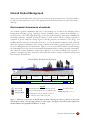
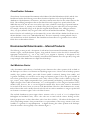
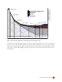
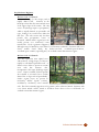
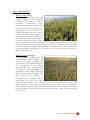
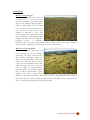
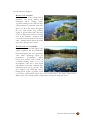
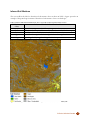
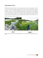
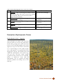
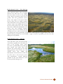
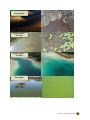
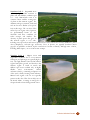
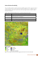
 Enhanced Wetland Classification Inferred Products User Guide Version 1.0 September 2011
Table of Contents
List of Figures and Tables................................................................................................... 3 Introduction ......................................................................................................................... 4 Inferred Product Background .............................................................................................. 5 Environmental determinants of wetlands........................................................................ 5 Classification Schemes ................................................................................................... 7 Environmental Determinants – Inferred Products .............................................................. 7 Soil Moisture Factor ....................................................................................................... 7 Description of moisture classes ................................................................................ 10 Inferred Soil Moisture ............................................................................................... 15 Hydrodynamic Factor ................................................................................................... 16 Description of Hydrodynamic Classes...................................................................... 17 Inferred Hydrodynamics ........................................................................................... 20 Nutrient Availability Factor .......................................................................................... 21 Description of Nutrient Regime Classes ................................................................... 24 Inferred Nutrient Availability ................................................................................... 27 Conclusion and Summary ................................................................................................. 28 References ......................................................................................................................... 29 © Ducks Unlimited Canada
2
List of Figures and Tables
Figure 1. Landscape cross-section of Boreal Plains wetlands showing the relative positions of the
major wetland types and the corresponding positions of water regime, soil regime, and nutrient
status (adapted to the Boreal Plains and expanded from Harris et. al. 1996). ..............................5
Figure 2. Edatopic grid showing the distribution of wetland classes in relation to inferred
moisture, nutrient, and hydrodynamic regimes.............................................................................6
Table 1. Relative soil moisture code derivation guide. Adapted and expanded from Beckingham
and Archibald 1996. ......................................................................................................................8
Figure 3. General relationship between landscape position and moisture code. ..........................9
Table 2. Enhanced Wetland Classification class cross-walk to inferred soil moisture classes. .15
Figure 4. An example of the soil moisture inferred product from an area near Ft. Nelson, BC. 15
Figure 5. A marsh area in the boreal with a large difference in water table elevation throughout
the growing season......................................................................................................................16
Table 3. Inferred hydrodynamic factor classes for wetlands. .....................................................17
Table 4. Enhanced Wetland Classification class cross-walk to inferred hydrodynamic classes.20
Figure 6. An example of the hydrodynamic product from an area near Ft. Nelson, BC. ...........20
Table 5. Ground-level determinants of nutrient regime code (adapted and expanded from
Mackenzie and Moran 2004). .....................................................................................................22
Table 6. General characteristics of water with different trophic status (adapted from Mackenzie
and Moran, 2004) (also shown in Figure 9)................................................................................22
Figure 7. Field photos of water bodies and the association between water color and nutrient
regime. ........................................................................................................................................23
Table 7. Enhanced Wetland Classification class cross-walk to inferred nutrient classes ..........27
Figure 8. An example of the inferred nutrient regime product from an area near Ft. Nelson, BC.
.....................................................................................................................................................27
© Ducks Unlimited Canada
3
Introduction
In recent years, Ducks Unlimited Canada (DUC) has initiated an increasing number of research and
inventory programs that highlight the importance of boreal wetlands in Canada. It is well established that
these wetland ecosystems are important in that they provide numerous ecological goods and services, some
of which include: wetlands filter our water; recharge our groundwater supplies; mitigate the effects of
flooding and droughts; remove carbon from the atmosphere; as well as support diverse flora and fauna. In
direct contrast to this vast and important global resource is the relative lack of information on Canada’s
boreal wetland resources, specifically wetland maps that identify the type, extent, and distribution of these
systems. These maps, which help focus DUC’s conservation efforts, are needed in part to determine critical
waterfowl habitat, aid with impact assessments of industrial activities, provide critical inputs to scientific
research and modeling efforts such as climate change, and support various international/national/provincial
wetland mapping/monitoring programs (e.g. North American Waterfowl Management Plan, Canadian
Wetland Inventory, Alberta’s Water For Life program, etc.).
Ducks Unlimited has been leading the effort to provide detailed and accurate wetland maps for large areas
of the western boreal forest. This enhanced wetland classification (EWC) effort is a multi-partner
collaboration with several international (US Fish & Wildlife Service, US Forest Service, and the Pew
Charitable Trusts), national (Environment Canada), provincial and territorial agencies and industries
(various forestry and energy companies). To date, nearly 50 million hectares of wetlands have been
mapped.
This inventory effort is unique in that it uses detailed field data collected in helicopters to help guide the
classification of large-scale satellite images to map wetlands. Due to the complexity and diversity of
wetlands in the Boreal Plains ecozone, a field guide to boreal wetlands was developed by Ducks Unlimited
biologists to help understand and classify the various types of wetlands (bogs, fens, swamps, marshes and
shallow open water) found in this region (Smith et al 2007). A classification approach that uses image-object
oriented software was also developed to meet the challenges of mapping diverse and predominantly
interconnected wetland types over large geographic areas. This approach is flexible enough to be adapted
and applied to other boreal regions throughout Canada.
These mapping products have become the cornerstone of DUC’s Western Boreal Program by providing
baseline data to undertake other inventory elements, including waterbird surveys, associated research
projects and conservation planning. Beyond the baseline data, these wetland maps can also be used to create
various inferred products (such as relative nutrient regime, relative soil moisture regime, and relative
hydrodynamic regime) based on general groupings of the EWC wetland types. This guide describes how
these inferred products are generated, and how they can be used to provide information on how different
wetlands function. This detailed information on the underlying ecological determinants of wetland
ecosystems is critical in order to advance wetland conservation in the boreal forest.
© Ducks Unlimited Canada
4
Inferred Product Background
This section is directly taken from A field guide to the wetlands of the Boreal Plains Ecozone of Canada by Smith et
al. 2007. It is referenced here to serve as a background on how the inferred classes are represented on the
landscape.
Environmental determinants of wetlands
The wetland vegetation communities that exist on the landscape are a result of the underlying factors
forming them, including: geology, hydrology, nutrient availability, climate, position in the landscape etc.
Of these factors, water table depth (hydrology), water flow (hydrodynamics), and nutrient availability are
particularly important. Wetlands develop in response to these factors, and the resulting vegetation is
comprised of species adapted in varying degrees to flooding frequency and duration, wave energy, and
available dissolved minerals. Each wetland class has a set of environmental conditions which ultimately
dictate the vegetation assemblages. These varying conditions and resulting vegetation indicator species can
be used to distinguish between wetland classes. Figure 1 is a cross section of Boreal Plains wetlands showing
the relationship between the various environmental determinants and the resulting vegetation communities.
The enhanced wetland classification utilizes these differences in wetland conditions and vegetation to
generate a descriptive key and a decision tree that enables the reader to classify a wetland to six major and
nineteen minor wetland classes.
Boreal Plains Wetland Cross Section
Shallow/Open
Shore
Marshes
Water
Fens
Minerotrophic
Mineral Soil
Woody Peat
Sphagnum Peat
Rich Fens
Bogs
Poor
Fens
Ombrotrophic
Legend
Permanently flooded to intermittently exposed
Semi-permanently flooded to seasonally flooded
Permanently to semi-permanently saturated
No consistent contact with water table
Swamps
Upland
Minerotrophic
Low Water Level
High Water Level
Figure 1. Landscape cross-section of Boreal Plains wetlands showing the relative positions of the major
wetland types and the corresponding positions of water regime, soil regime, and nutrient status (adapted to
the Boreal Plains and expanded from Harris et. al. 1996).
© Ducks Unlimited Canada
5
The field guide also provides a classification based on three factors: moisture regime, nutrient regime, and
hydrodynamic regime. The relative combination of these factors is shown in edatopic grid format in Figure
2. For example, a field site with a very poor nutrient regime, hygric moisture regime, and a stagnant
hydrodynamic regime would be a bog. The nutrient regime is shown on the x-axis, the moisture regime on
the y-axis, and the hydrodynamic regime on the diagonal (2-d z-axis). This edatopic grid shows the relative
distribution of major wetland classes according to the relative combination of each of the three inferred
environmental determinants.
na
nt
ic
m
na e
dy m
r o gi
yd Re
H
ag
ow g
Sl vin
o
M
St
M
Mesic
ov
g
in
Bogs
D
yn
Hygric
Swamps
Fens
ry i c
Ve a m
yn
D
Hydric
Very
Hydric
ic
Subhydric
am
Moisture Regime
Subhygric
Marshes
Open Water
Very Poor Poor
Medium
Rich Very Rich Excess
Nutrient Regime
Figure 2. Edatopic grid showing the distribution of wetland classes in relation to inferred moisture, nutrient,
and hydrodynamic regimes.
This edatopic grid is modified from similar existing grids based on ordination of species (MacKenzie and
Moran 2004) and chemical and biotic gradients (Vitt et al. 1994) to represent the distribution of the various
EWC major level wetland classes. Field data from over 5,000 (n=5063) field sites was used to determine
the distribution of the various EWC major classes in relation to the various environmental determinants.
EWC major classes with a majority of sites within a particular position were given precedence over EWC
major classes with a minority of sites in the same position on the edatopic grid.
© Ducks Unlimited Canada
6
Classification Schemes
The inclusion of environmental determinants in the Enhanced Wetland Classification (EWC) and the class
breakdowns listed in the following section allows for inferred products to be developed that map the
distribution of hydrodynamics, soil moisture, and relative nutrient status based on the wetland classes in the
EWC. The underlying assumption is that each wetland class can be assigned to a specific inferred class.
While this may not be true in some cases (such as open water, which has a wide range of potential nutrient
regime classes from 1-5), in many cases wetlands can be placed categories where they are most prevalent.
For example, the majority of bogs can be placed in stagnant (hydrodynamic class), subhygric (moisture
class), very poor (nutrient class) categories of the various environmental determinants. The primary
inferred class for each wetland type was determined by a review of the field site database for all sites across
the Boreal Plains ecozone (over 5,000 individual sites). The most commonly occurring inferred class for
each wetland class was then determined. This classification scheme allows for a generalized cross-walk of
EWC classes to their inferred classes.
Environmental Determinants – Inferred Products
The following sections provide a description of each inferred environmental determinant (nutrient regime,
moisture regime, and hydrodynamic regime), along with the features used in the field to determine the
appropriate wetland class (e.g., wet vs. dry, rich vs. poor, stagnant vs. dynamic). A description of each
cross-walk from EWC minor class to majority environmental determinant class is also provided, along with
a map example of the distribution on a sample boreal landscape.
Soil Moisture Factor
A key determinant (and indicator) of wetland presence/function is the relative position of the wetland on
the landscape as it relates to soil moisture and hydrologic input source. Factors such as landscape position
(visible), slope gradient (visible), water table location (visible or inferred), drainage class (visible), and
vegetation community cues can all be used to assign soil moisture regime codes to any given wetland. In
areas where ground-level site information can be easily collected, features such as surficial geology (soil
type, texture, strata, depth to impermeable layer, parent material) and hydrology (soil moisture readings,
depth to/height of water table measurements, etc.) would typically be used to assign soil moisture classes
(SCWG 1998), however, due to cost and logistical restraints these factors often cannot be determined
across much of the more remote access areas of the Boreal Plains. Therefore, this classification uses several
inferred factors that can be visually observed and collected via aerial reconnaissance to assign a specific field
site location to a moisture regime code to a field site location.
This wetland classification system assigns relative moisture codes on a scale of 1 to 10 (adapted from
Beckingham and Archibald 1996). These codes take into account both the relative drainage and the
hydrologic input source to derive this relative scale of ten classes (Table 1). The inferred soil moisture code
(and corresponding moisture class) presented here is a representation of the average amount of soil water
available to vegetation for evapotranspiration. A diagram showing the relative position in the landscape
where the moisture classes typically occur is shown in Figure 3.
© Ducks Unlimited Canada
7
Table 1. Relative soil moisture code derivation guide. Adapted and expanded from Beckingham and
Archibald 1996.
General
Water
Hydrologic
Position
Soil
Soil
Slope
Moisture
Moisture
Table
Input Source
On
Moisture
Drainage
Gradient
Code
Class
Location
Landscape
Regime
Class1
(degrees)
No
Precipitation
Ridge, crest
Extremely
Very
Very Steep
1
Contact
Xeric
Rapid
(>70°)
Very Dry
Well
Precipitation
Ridge, crest,
Xeric
Very Rapid Very Steep
2
Below
upper slopes
to Rapid
(>70°)
Surface
Below
Precipitation
Upper
Subxeric
Rapid
Steep
3
Dry
Surface
Slopes
(31-70°)
Below
Precipitation
Upper to
Submesic
Rapid to
Steep
4
Surface
Mid Slopes
Well
(31-70°)
At/Below
Precipitation/
Mid to
Mesic
Well to
Slight to
5
Surface
Groundwater
Lower
Moderately
Moderate
Mesic/
Slopes
Well
(2-30°)
Moist
At/Below Groundwater/
Domes,
Subhygric
Moderately
Slight
6
Surface
Precipitation
Lower
Well to
(2-9°)
Slopes to
Imperfect
Flat
At/Above
Surface/
Lower
Hygric
Imperfect to
Slight
7
Surface
Groundwater
Slopes to
Poor
(2-9°)
Wet
Seepage
Flat
Above
Surface/
Depressions
Subhydric
Poor to
Slight
8
Surface
Groundwater
Very Poor
(2-9°)
Seepage
Above
Permanent
Depressions
Hydric
Very Poor
Flat
9
Very Wet
Surface
Water Table
(<2°)
Above
Permanent
Basin
Extremely
Water
Flat (<2°)
10
Surface
Water Table
Hydric
1
Adapted from Soil Survey Division Staff (1993)
© Ducks Unlimited Canada
8
Height 1-500 meters
(vertically exaggerated)
Ridge, Crest
Depth of Surface Organic Layer
Mineral Soils
Bedrock
Water Table
Upper Slope
Mid-Slopes
Lower Slopes
1,2
3,4
5
6,7,8
Level
7,8,9
Receiving
Depression
8,9,10
8,9
Dome
6
Moisture Code
Figure 3. General relationship between landscape position and moisture code.
It should be noted that throughout this guide, when we mention groundwater we refer to water that has
been in contact with minerals/nutrients and includes shallow subsurface water, but rarely includes
groundwater from deepwater aquifers. Deepwater aquifers are present in the Boreal Plains, but their
connection to wetlands and discharge/recharge functions are not well understood and beyond the scope of
this field guide.
© Ducks Unlimited Canada
9
Description of moisture classes:
The following description of each moisture class (and associated moisture code for tracking purposes) is
intended to aid in field determination. The examples for the very dry regimes are from the Montane
Cordillera (Extremely Xeric) and the Boreal Shield (Xeric), because these classes rarely occur in the Boreal
Plains.
Very Dry Regimes:
Moisture Code 1: Extremely Xeric
Terrain with very steep slopes (>70%) or
crests/ridges/high points of landscape with
an impermeable substrate or water is in solid
form (ice). This class consists of rock areas
where surface runoff is immediate with little
or no soil development and no contact with
the water table at any time. The primary
hydrologic input is through precipitation,
which is very rapidly drained. Soils are
primarily very coarse mineral soils, with
little or no organic soil present. No
vegetation is present in this class due to the constant water deficit and lack of soil development.
This class includes upland areas such as rock faces of mountain crests, exposed granite shield, or
glaciers. Common earth cover classes would include rock and/or ice. No wetlands exist in this
moisture regime, and this class rarely occurs in the Boreal Plains.
Moisture Code 2: Xeric
Terrain with very steep slopes and/or very
rapidly permeable soil types. This
immediate drainage creates an extreme
water deficit, which in turn limits
vegetation growth. Precipitation is the only
hydrologic input for this moisture class, and
soil moisture is removed very rapidly. The
resulting water table is well below surface
with no visible influence on land surface.
This class occurs in upland areas on ridge
tops and topographic highs of the terrain.
Soils are mainly coarse mineral soils, with
little or no organic soil present. Common
earth cover classes include rock, gravel, non-vegetated soil, sparse vegetation, and dwarf shrub
classes. No wetlands exist in this moisture regime.
© Ducks Unlimited Canada
10
Dry Moisture Regimes:
Moisture Code 3: Subxeric
Terrain with steep (31-70% slopes) and/or
rapidly drained soils. Positions on the
landscape where this class exists include most
of the upper slopes of the terrain. The only
source of hydrologic input is precipitation,
which is rapidly drained via permeable soil
types, leading to an overall water deficit for
this class. The soil is moist only for short
periods after precipitation events or
snowmelt. Shallow surface organic layers are
usually present over moderately coarse
mineral soils. Treed vegetation is supported,
although it may be limited by water deficit or soil/nutrient conditions. Common earth cover
classes include dwarf shrub, dry herbaceous/forb, woodland/open/deciduous,
woodland/open/conifers (especially pine). No wetlands exist in this moisture regime.
Moisture Code 4: Submesic
This class represents most upland areas
with moderate to high slopes (31-70%) in
rapidly to well-drained permeable soils. A
distinct water deficit is present in terrain
areas with this moisture class.
Precipitation is the major hydrologic input
source. Water is available for short periods
after rainfall or snowmelt but is readily
drained due to slope and soil permeability.
Surface organic layers are present in
moderately shallow depths (<10cm),
underlain by moderately coarse mineral
soils. This class commonly supports treed vegetation, unless otherwise limited. Common earth
cover classes include conifer, mixed or deciduous forest classes or low to tall shrubs. No
wetlands exist in this moisture regime.
© Ducks Unlimited Canada
11
Mesic/Moist Regimes:
Moisture Code 5: Mesic
This class represents upland areas with
midslope rolling to flat topographic
positions (2-30% slopes) in well to
moderately
well-drained
slopes.
Precipitation is the major hydrologic input
source, but groundwater seepage may also
contribute in some areas. Soil water is
available throughout the year and is
removed somewhat slowly compared to
precipitation inputs. The resulting water
table is often near the surface, but little or
no standing water exists. Surface organic
layers are usually present with moderate (10-15cm) depths, underlain by a variety of medium
to fine grained mineral soils. This class supports a wide variety of vegetation due to abundant
moisture, soil mineral availability, and soil drainage. Common earth cover classes include most
closed/open/mixed deciduous and/or conifer forest types. No wetland classes are present in
this moisture regime class.
Moisture Code 6: Subhygric
This class marks the beginning of the
wetland-associated moisture regimes and
occurs in lower slopes, peatlands, and
receiving areas of the landscape (slopes 09%). Precipitation is the primary
hydrologic input source for the peatland
areas (bogs), while precipitation and
groundwater are the primary hydrologic
input sources for many of the lower slope
and receiving areas. Drainage is
moderately well to imperfect and no
water deficit occurs. The soil is either
saturated in the rooting zone or at the surface for most or all of the growing season. The
surface organic layer ranges from moderately deep to deep (10-40cm+), but this depth is
widely variable. Common earth cover classes include open/closed deciduous and conifer
forests, and tall/low shrubs. Wetland classes include some bogs, drier conifer swamps, and
some poor fens.
© Ducks Unlimited Canada
12
Wet Regimes:
Moisture Code 7: Hygric
This class represents lower slopes to
receiving areas to level areas of the
landscape with little or no slope gradient
(0-9%). The primary hydrologic input is
surface or groundwater. The water table
is at or above the surface for most of the
year, and thus no water deficit exists.
Drainage is imperfect to poor. The
surface organic layer is deep and typically
greater than 40 cm. This moisture regime
supports tall shrubs and trees adapted to
prolonged periods of inundation.
Common earth cover types include closed/open/woodland conifer, closed/open deciduous,
tall/low shrub. Wetland types include bogs, wetter fens, and swamps.
Moisture Code 8: Subhydric
This class represents depressions and
level receiving areas of the landscape
with little or no slope present (0-9%).
The primary hydrologic inputs are
surface and/or groundwater. The water
table is at or above the surface for most
of the year (near-permanent water table
visible). Drainage is poor to very poor.
Soils are organic or gleyed mineral,
typically with very deep surface organic
layers (>40cm). This moisture regime
supports only sparse, stunted trees
adapted to prolonged inundation, tall and low shrubs, and graminoid/forb/bryophytes.
Common earth cover classes include woodland conifer, tall shrub, and wet graminoid/forb
classes. Wetland classes include wetter fens and swamps.
© Ducks Unlimited Canada
13
Very Wet Moisture Regimes:
Moisture Code 9: Hydric
This class occurs in flat terrain that is
inundated, very poorly drained, with
submerged and/or floating aquatic
vegetation usually present. This class has a
semi-permanent to permanent water table
that is at or above the surface throughout
the year. Soils include deep (>40cm)
organic or gleyed mineral soils. This class
occurs in depressions and level receiving
areas in the landscape. Common earth
cover classes include aquatic bed and open
water. Wetland classes include the marsh
major class, and open water classes.
Moisture Code 10: Very Hydric
Deep open water areas that support only
aquatic vegetation and are permanently
flooded throughout the year (permanent
water table). Hydrologic inputs are
groundwater,
precipitation,
inflow
(creek, river, stream), surface runoff, or
over-bank flooding. Little or no soil
development occurs due to water depth
and duration of anaerobic conditions (but
sedimentary peat may be present). This
class supports only submerged and/or
floating-leaved aquatic vegetation. Earth
cover classes would include aquatic bed, clear or turbid water. The major wetland class is
shallow open water with the minor wetland classes of aquatic bed and open water.
© Ducks Unlimited Canada
14
Inferred Soil Moisture
The cross-walk for the EWC to the inferred soil moisture classes is shown in Table 2. Figure 4 provides an
example of the spatial representation of the inferred soil moisture classes on a landscape.
Table 2. Enhanced Wetland Classification class cross-walk to inferred soil moisture classes.
Soil Moisture
Class
Very Hydric
Hydric
Subhydric
Hygric
Subhygric
Enhanced Wetland Classification Classes
Open Water, Aquatic Bed, Mudflats, Emergent Marsh
Rich Graminoid Fen, Poor Graminoid Fen, Meadow Marsh, Shrub Swamp
Shrubby Rich Fen, Shrubby Poor Fen, Treed Rich Fen
Mixedwood Swamp, Tamarack Swamp, Hardwood Swamp, Treed Poor Fen
Open Bog, Shrubby Bog, Treed Bog, Conifer Swamp
Figure 4. An example of the soil moisture inferred product from an area near Ft. Nelson, BC.
© Ducks Unlimited Canada
15
Hydrodynamic Factor
The lateral and vertical movement of water through wetland systems (i.e. hydrodynamics) is another
important factor in the determination of wetland type. Movement of water can be groundwater or surface
water, and for the purposes of this field guide groundwater movement is inferred from the position in the
landscape, vegetation, and visible hydrologic features (Table 3). Hydrodynamic energy influences
decomposition of organic material (by providing a mechanism for aeration), limits growth or establishment
of vegetation, and stresses the vegetation due to physical damage (in higher wave energy environment
areas). The hydrodynamic regime can be fairly static such as the percolation/capillary action of
precipitation-driven hydrodynamics in bogs to the hydrodynamically variable marshes on exposed shores of
water bodies with regular drawdowns (Figure 5).
Figure 5. A marsh area in the boreal with a large difference in water table elevation throughout the growing
season.
© Ducks Unlimited Canada
16
Table 3. Inferred hydrodynamic factor classes for wetlands.
Class Movement of Water
1 Stagnant – Stable, non-flowing areas with no vertical
hydroperiod change. Movement of soil water is stagnant
to very gradual, with no movement at the surface,
despite constant saturation.
2 Slow Moving – Gradual flow through with minor
vertical hydroperiod change.
3 Moving – Vertical hydroperiod change common,
lateral water movement.
4 Dynamic – Strong Vertical/Lateral movement of
water.
5 Very Dynamic – High water displacement areas.
Associated Wetland Classes
Bogs, Poor Fens, Swamps
Poor to richer Fens, Swamps,
Open Water
Rich Fens, Swamps, Marshes,
Open Water
Swamps, Marshes, Open
Water
Marshes, Open Water
Description of Hydrodynamic Classes
Hydrodynamic Code 1 – Stagnant
Areas with little to no surface water movement
and water table is at or below the ground surface
for the entire growing season. Water movement
in these areas is through capillary action in the
upper layers of peat or soil. There is often little
to no vertical change in water tables in these
areas, with stagnant to very gradual lateral flow
through these systems. The wetland classes that
exhibit this hydrodynamic class include bogs,
very poor fens, and poor conifer swamps.
Vegetation in these areas may be treed, shrubby,
bryoid, or herbaceous. Areas with this
hydrodynamic class are typically the higher
elevation peatland and swamp areas in the
landscape.
© Ducks Unlimited Canada
17
Hydrodynamic Code 2 – Slow Moving
Areas with some surface water movement
and the water table may be at to slightly
above the surface for most of the growing
season. Water movement in these areas is
gradual, with some groundwater and/or
surface water inputs to the system. Water
levels in these areas are usually constant,
with continual flows from groundwater, but
extensive surface water inputs may increase
the water table in these areas. The wetland
classes that exhibit this hydrodynamic class
include Fens and Tamarack Swamps.
Vegetation may be Treed, Shrubby, Bryoid,
or herbaceous, but is often associated with
poor nutrient sites as the groundwater (and therefore nutrient inputs) are slighter than in other areas.
Typical landscape positions are in the middle to upper elevations of peatlands, just above the main
drainage areas in peatlands.
Hydrodynamic Code 3 – Moving
Areas with surface water movement and the
water table is typically above the surface for
most of the growing season. Water
movement is predominately lateral through
these systems, but surface flows may
influence the vertical change in water table
during peak flow times of the year. The
wetland classes that exhibit this
hydrodynamic class include most of the rich
fen classes (due to the increased contact
with groundwater). Typical landscape
positions for this class include the lower
elevation peatland drainage areas.
© Ducks Unlimited Canada
18
Hydrodynamic Code 4 – Dynamic
Areas with significant surface water
movement but water table may be at,
above, or slightly below surface during the
growing season. Water movement in these
areas is both lateral and vertical, with large
differences in surface flow that create a
wide range of water table elevation
throughout the year in these wetland
systems. Vegetation is often treed,
shrubby, or herbaceous in these areas. The
wetland classes that exhibit this
hydrodynamic class include swamps and
shallow open water wetland classes.
Typical landscape positions include the
receiving slopes, drainage areas, and water
bodies in local to regional lower elevation
zones.
Hydrodynamic Code 5 – Very Dynamic
Areas with a highly variable surface
water movement/displacement and
water table may be at, well above, or
well below the surface during the
growing season. Water movement in
these areas is both lateral and vertical,
with extreme differences in the surface
flow that create the wide range of water
table elevation throughout the year in
these systems. Due to the highly
fluctuating water table, vegetation in
these areas is limited to plants that can
tolerate these conditions such as
emergent vegetation. No shrubs or trees
are found in areas of this hydrodynamic class. Wetland classes include marshes, mudflats, and exposed
areas of shallow water wetlands. Typical landscape positions include areas adjacent to water bodies,
lower parts of catchments, depressions, and tidal or seche influenced mudflats along larger water
bodies.
© Ducks Unlimited Canada
19
Inferred Hydrodynamics
The cross-walk for the EWC to the inferred soil hydrodynmaics is shown in Table 4. Figure 6 provides an
example of the spatial representation of the inferred hydrodynamic classes on a landscape.
Table 4. Enhanced Wetland Classification class cross-walk to inferred hydrodynamic classes.
Hydrodynamic
Class
Very Dynamic
Dynamic
Moving
Slow Moving
Stagnant
Enhanced Wetland Classification Classes
Emergent Marsh, Mudflats, Meadow Marsh
Mixedwood Swamp, Hardwood Swamp, Shrub Swamp, Open Water,
Aquatic Bed
Shrubby Rich Fen, Graminoid Rich Fen, Treed Rich Fen
Treed Poor Fen, Shrubby Poor Fen, Tamarack Swamp, Graminoid Poor Fen
Open Bog, Shrubby Bog, Treed Bog, Conifer Swamp
Figure 6. An example of the hydrodynamic product from an area near Ft. Nelson, BC.
© Ducks Unlimited Canada
20
Nutrient Availability Factor
Nutrient availability in wetlands is often assessed with ground-based measurements of soil and water
chemistry which include pH, concentrations of dissolved nutrients, and inherent soil characteristics (i.e.
color, texture, structure, C:N ratio – see Table 5). The degree of contact with nutrient-rich ground or
surface water determines the total amount of nutrients available to the vegetation. This field guide utilizes
several inferred factors that can be collected via helicopter or aircraft reconnaissance to assign a specific
nutrient regime code to an overall field site location. Factors such as soil type, water color (Table 6, Figure
7), hydrology, vegetation species richness, vegetation indicator species and other factors can all be observed
in the field and used in this classification.
In both peatland and mineral-soil wetlands, there is a link between water chemistry (available nutrients,
pH), moisture regime, and plant species assemblages. Plants, like other organisms, have a habitat niche, or
a certain set of conditions, under which they thrive (live and reproduce). Some species are generalists and
can thrive in a wide-range of environmental conditions (e.g., environmental variables such as moisture
gradients, nutrient availability, pH, alkalinity), while others, the specialists, need a very specific set of
conditions. Plant species that respond to a narrow set of environmental variables (i.e., they do not grow
outside these conditions) can be used as indicators of specific ecosystems. For example, observing a high
percent cover of Sphagnum fuscum would indicate low pH, relatively dry and nutrient poor environment on
the peatland scale from rich fen to bog. Further, because this species does well in poor conditions and a
water table that is below the surface, it can be used to predict that there is no or very little mineral water
input into the system, and thus the overall nutrient status of the site is poor.
This relationship of plant species and water chemistry has originally been identified by Sjörs (1952) in
Swedish mires but has been adapted to North American wetlands (e.g., see NWWG 1988). Specifically in
Alberta, studies by Vitt and Chee (1990) and Chee and Vitt (1989), and other similar studies showed
relationships between plant assemblages and water chemistry. Such vegetation-water chemistry and
moisture regime knowledge has been used extensively in the development of wetland, forest, or ecosite
classification systems (e.g., see Harris et al. 1996; Archibald and Beckingham 1996; Jeglum 1971, 1973,
and 1991). Often statistical programs such a TWINSPAN analysis in combination with an ordination
analysis is used to correlate species presence with environmental data. These empirically-derived studies
provide the basis for this guide/classification, which was then tested in the field.
In general, Vitt (1994) categorized Alberta fens into three broad categories: Poor fens (pH 4.5-5.5), poor
in base cations, no or little alkalinity; moderate-rich fens (pH 5.5-7.0), low to moderate alkalinity and
concentration of cations; extreme-rich fens (pH above 7.0), high concentrations of base cations and high
alkalinity, and possibly marl deposits. To make the distinctions between moderate-rich fens and extreme
rich fens is very difficult in a remote sensing application, and these two fen types are grouped together as
rich fens in our classification. However, this classification distinguishes poor and rich fen types based
largely on nutrient status and species assemblages (see the Boreal Plains Wetland Key. Swamps, including
conifer swamps, are not separated in this classification by nutrient status, even though they range from poor
to very rich. This was done because in many cases, separation via remote sensing was difficult to impossible
based on the spectral signatures alone.
© Ducks Unlimited Canada
21
Table 5. Ground-level determinants of nutrient regime code (adapted and expanded from Mackenzie and
Moran 2004).
Nutrient Regime Code
Feature
Specific
Variable
1
Very Poor
2
Poor
3
Medium
4
Rich
5
Very Rich
6
Hyper
Dissolved
Nutrients
Available
Nutrients
Very Low
Low
Average
Plentiful
Abundant
Excess
Water pH
< 5.0
4.5 – 6.0
5.0 – 6.5
6.0 – 7.4
6.5 – 8.0
> 8.0
Deep Brown - Yellow
Green-Brown -Clear
Green-Brown - Turbid
Water Color
Water
Ground
water flow
Stagnant
Surface
Tier
Saturation
Always saturated
Continuous Seepage
seasonal seepage
Seasonal exposure of substrate
Diurnal exposure
vonPost of
surface tier
Soil
Blue/
Green,Clear
1-3
3-6
SurfaceTier
Material
Organic
Surface
Peat Color
Pale
4-7
7-10
8-10
N/A
Marl
Mineral
Dark
High
C:N Ratio
Medium
Low
Relative
Productivity
Very Low
Low
Medium
High
High
Low
Species
Richness
Very Low
Low
Medium
High
High
Low
Plants
Table 6. General characteristics of water with different trophic status (adapted from Mackenzie and Moran,
2004) (also shown in Figure 9).
Nutrient
Status
Dystrophic
Oligotrophic
(Ca – Poor)
Oligotrophic
(Ca – Rich)
Eutrophic
Characteristic
Water Color
Yellow-Deep
Brown
Greenishbrownish
Blue-Greenish
GreenishBrownish
Water
Clarity
Stained
pH
< 4.5
Nitrogen
and Nutrient
Mineral Availability Code
Very Low
1
Clear
4.5-7
Low
2-3
Very Clear
>7
Medium
3-4
Turbid
>7
High-Very High
5
© Ducks Unlimited Canada
22
Dystrophic
Oligotrophic –
Ca Poor
Oligotrophic –
Ca Rich
Eutrophic
Figure 7. Field photos of water bodies and the association between water color and nutrient regime.
© Ducks Unlimited Canada
23
Description of Nutrient Regime Classes
Nutrient Code 1 -Very Poor: Areas with very low
available nutrients to plants, typically due to low base
cation availability as a result of highly acidic (pH < 5.)
conditions. Wetlands with these conditions are peatland
organic soil wetland types (bogs, poor fens). The von
Post of the surface organic layer is typically fibric (1-3).
These areas typically have little or no contact with
mineral-rich water, but the surface is typically saturated
due to ombrogenous inputs. Vegetation growing in these
conditions are either species adapted specifically to the
conditions or generalist species that can grow over a
wide range of environmental conditions. The relative
number of vegetative species is very low, with a
dominance of Sphagnum mosses and ericaceous shrubs.
Trees, if present (trees are limited by hydric conditions
as well as nutrients), are typically < 2 m tall, and are
primarily stunted Black Spruce (Picea mariana).
Nutrient Code 2 – Poor: Areas
with low available nutrients, and
fairly high acidic conditions (pH 4.5
– 6.0). Wetlands with these
conditions are peatland organic soil
wetland types (bogs, fens, and
poorer conifer swamps). The von
Post of the surface organic layer is
typically fibric to mesic (3-6). These
areas have some contact with
mineral-rich water. A slightly wider
range of species can be found in poor
nutrient regime areas compared to
very poor nutrient regime areas,
including most of the dominant
species found in Nutrient Code 1.
Some minerotrophic species begin to occur, including bog birch (Betula spp.), Tamarack (Larix laricina),
and horsetail (Equisetum fluviatile). Trees are more common to this nutrient regime (Picea mariana, Larix
laricina), but heights are generally < 10 m.
© Ducks Unlimited Canada
24
Nutrient Code 3 – Medium: Areas
with fairly high available nutrients to
plants, typically with slightly acidic
conditions (pH 5.0 -6.5). Contact
with mineral-rich water is more
common to this nutrient regime
compared to the poor nutrient
regimes (nutrient codes 1 and 2).
The dominant soil type is organic,
although some mineral wetlands fall
into this class. The von Post scale of
decomposition (Appendix D) of the
surface organic layer, if present, is
mesic (4-7). Wetlands with these
conditions are fens, swamps, and
some poorer marshes (sedge
meadow marshes typically on
deposited peat soils). A wider range of minerotrophic species exists in this nutrient regime, including
Caltha palustris (Marsh marigold), Petasites frigidus (Arrow-leafed Coltsfoot), and Calamagrostis canadensis
(Bluejoint grass). Trees, if present, are Black Spruce and Tamarack, and can be taller than 10 meters.
Nutrient Code 4 – Rich: Areas
with high available nutrients to
plants, typically due to the more
neutral pH ranges (6.0 -7.4).
Contact with mineral-rich water is
prevalent to plants in this nutrient
regime. The dominant soil type is
mineral, although some richer
organic soil wetlands fall into this
class. The von Post of the surface
organic layer, if present is humic (710). Wetlands with these conditions
are rich fens, all swamp classes, and
marshes. The number of plant
species in these types of wetlands is
high, particularly for the herbs,
forbs, and mosses. Mosses, if present, are typically brown mosses and some Sphagnum. Minerotrophic
species that exist in this nutrient regime include: Juniperus communis (Common Juniper), Potentilla
fruticosa (Shrubby Cinquefoil), and Parnassia palustris (Grass of Parnassis) in fens; and Salix spp.
(Willows), Cornus stolonifera (Red-Osier Dogwood), and Rhamnus alnifolia (Alder-leaved Buckthorn) in
swamps. Trees, if present, include all common wetland conifers and deciduous trees, and range in
heights to well above 10 m.
© Ducks Unlimited Canada
25
Nutrient Code 5 – Very Rich: Areas
with very high available nutrients to
plants and with alkaline conditions (pH
6.5 – 8.0). Mineral-rich water is in
constant contact with the rooting zone
of plants in this nutrient regime. The
dominant soil type is mineral, with marl
soils in the more alkaline (near pH of
8.0) in this range. The von Post of the
surface layer of organic soils, if present,
are predominantly humic (8 -10).
Wetlands with these conditions are
richer swamps, and marshes. The
diversity of plant species that grow in
this nutrient regime is very wide,
including some species that exist in more upland areas as well, such as Rosa acicularis (Wild Rose), Rubus
ideaeus (Raspberry), and Ribes spp. (Currents). Trees, if present, are typically deciduous (Betula
papyrifera in palustrine wetlands, Populus tremuloides in riverine wetlands), although some conifers,
including White Spruce, can occur in riverine swamps.
Nutrient Code 6 – Hyper: Areas with
hypersaline conditions due to excess mineralrich inputs, and pH ranges are typically high (>
8.0). The high salinities found in this nutrient
regime limit plant growth, and therefore this
nutrient regime is found in marsh and
shallow/open water wetlands only. In highly
alkaline water environments, calcium
carbonate (CaCO3) commonly precipitates out
of the water column, forming a marl substrate.
Mineral and organic soils are not typically
present in this class. This class is fairly rare in
the Boreal Plains, occurring as marl pools or
salt ponds with associated fringe marsh classes.
© Ducks Unlimited Canada
26
Inferred Nutrient Availability
The cross-walk for the EWC to the inferred nutrient availability is shown in Table 7. Figure 8 provides an
example of the spatial representation of the inferred nutrient availability classes on a landscape. For this
inferred classification, open water was left out due to the wider range of nutrient conditions exhibited
within this wetland class.
Table 7. Enhanced Wetland Classification class cross-walk to inferred nutrient classes.
Nutrient Class
Very Rich
Rich
Medium
Poor
Very Poor
Enhanced Wetland Classification Classes
Emergent Marsh, Mudflats, Meadow Marsh
Mixedwood Swamp, Hardwood Swamp, Shrub Swamp, Shrubby Rich Fen,
Graminoid Rich Fen, Treed Rich Fen
Conifer Swamp, Tamarack Swamp
Treed Poor Fen, Shrubby Poor Fen, Graminoid Poor Fen
Open Bog, Shrubby Bog, Treed Bog
Figure 8. An example of the inferred nutrient regime product from an area near Ft. Nelson, BC.
© Ducks Unlimited Canada
27
Conclusion and Summary
This guide provides an overview of the inferred products that can be derived from Ducks Unlimited
Canada’s Enhanced Wetland Classification (EWC). Three different inferred products can be produced: soil
moisture, hydrodynamics, and nutrients. Field data from over 5,000 field sites was used to determine the
predominant inferred class for each product by minor wetland class. This allows for the user to infer how
water is moving though the landscape, how moist the surface is expected to be, and the inferred nutrient
condition of different wetland areas across the landscape. This information can be used in conjunction with
other data to better inform planning and operational practices around wetlands by government and industry
partners.
For more information:
Data requests
Alain Richard, [email protected]
(780) 489-8110
Technical enquiries
Kevin Smith, [email protected]
(780) 489-8110
Ducks Unlimited Canada (DUC) is a private, non‐profit organization that conserves, manages and restores wetlands and associated habitats for waterfowl. These habitats also benefit other wildlife and people. © Ducks Unlimited Canada
28
References
Beckingham, J.D., and J.H. Archibald. 1996a. Field Guide to ecosites of northern Alberta. Nat. Resour.
Can., Can. For. Serv., Northwest Reg., North. For. Cent., Edmonton, Alberta. Spec. Rep. 5.
Beckingham, J.D., D.G. Nielsen, and V.A. Futoransky. 1996b. Field guide to ecosites of the mid-boreal
ecoregions of Saskatchewan. Nat. Resour. Can., Can. For. Serv., Northwest Reg., North. For. Cent.,
Edmonton, Alberta. Spec. Rep. 6.
Chee, W. and Vitt, D.H. 1989. The vegetation, surface water and peat chemistry of moderate-rich fens in
central Alberta, Canada. Wetlands. 9:227-261.
Harris, A.G., S.C. McMurray, P.W.C. Uhlig, J.K. Jeglum, R.F. Forster, and G.D. Racey. 1996. Field
guide to wetland ecosystem classification for northwestern Ontario. Ont. Min. Natur. Resour.,
Northwest Sci. & Technol. Thunder Bay, Ont. Field Guide FG-01. 74pp + Append.
Jeglum, J.K. 1991. Definition of trophic classes in wooded peatlands by means of vegetation types and plant
indicators. Ann. Bot. Fenn. 28: 175–192.
Jeglum, J.K. 1973. Boreal forest wetlands near central Saskatchewan. II. Relationships of vegetational
variations to major environmental gradients. The Musk-ox 12:32-48.
Jeglum, J.K. 1971. Plant indicators of pH and water levels in peatlands at Candle Lake, Saskatchewan. Can.
J. Bot. 49: 1661-1676.
Mackenzie, W.H. and J.R. Moran. 2004. Wetlands of British Columbia: a guide to identification. Res.
BR., B.C. Min. For., Victoria, D.C. Land Manage. Handb. No. 52.
National Wetlands Working Group. 1988. Wetlands of Canada. Ecological Land Classifcation Series, No.
24. Sustainable Development Branch, Environment Canada, Ottawa, Ontario, and Polyscience
Publications Inc., Montreal, Quebec. 452 p.
Racey, G.D., A.G. Harris, J.K. Jeglum, R.F. Foster, and G.M. Wickware. 1996. Terrestrial and Wetland
Ecosites of Northwestern Ontario. Ont. Min. Natur. Resour., Northwest Sci. & Technol. Field Guide
FG – 02. 94 pp. + Append.
Sjörs, H. 1952. On the Relation between Vegetation and Electrolytes in North Swedish Mire Waters.
Oikos. 2:241-258.
Smith, K.B, C.E. Smith, S.F. Forest, and A.J. Richard. 2007. A Field Guide to the Wetlands of the Boreal
Plains Ecozone of Canada. Ducks Unlimited Canada, Western Boreal Office: Edmonton, Alberta. 102
pp.
Soil Classification Working Group. 1998. The Canadian System of Soil Classification, 3rd ed. Agriculture
and Agri-Food Canada Publication 1646, 187 pp.
© Ducks Unlimited Canada
29
Soil Survey Division Staff. 1993. Soil Survey Manual. Agricultural Handbook No. 18 Revised. U.S.
Department of Agriculture, Washington, D.C.
Vitt, D.H. 1994. An overview of factors that influence the development of
Entm. Soc. Can. 169:7-20.
Canadian peatlands. Mem.
Vitt, D.H and W.L. Chee. 1990. The Relationship of Vegetation to Surface Water Chemistry and Peat
Chemistry in Fens of Alberta, Canada. Vegetatio. 89: 87–106.
Vitt, D. H., L.A. Halsey, S.C. Zoltai. 1994. The bog landforms of continental western Canada in relations
to climate and permafrost patterns. Arctic and Alpine Research 26 (1):1-13.
Vitt, D.H., Halsey, L.A., Thormann, M.N. and Martin, T. (1996) Peatland Inventory of Alberta. Phase 1:
Overview of peatland resources in the natural regions and subregions of the province. Stephen C.
Zoltai Peatland Resource Center, Devonian Botanic Garden, University of Alberta, Edmonton,
Alberta.
Warner, B.G. and C.D.A. Rubec. (Eds.). 1997. The Canadian Wetland Classification System, Second
Edition. National Wetlands Working Group. Wetlands Research Centre, University of Waterloo.
Waterloo, Ontario. 68pp.
© Ducks Unlimited Canada
30