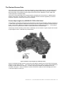
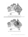
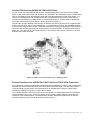
1
GEODATA 9 Second
DEM and D8
Digital Elevation Model Version 3 and
Flow Direction Grid
Gridded Elevation and Drainage Data
Source Scale 1:250 000
User Guide
FENNER SCHOOL OF ENVIRONMENT AND SOCIETY, ANU and
GEOSCIENCE AUSTRALIA
A cooperative effort by Geoscience Australia and the
Fenner School of Environment and Society,
The Australian National University
Department of Resources, Energy and Tourism
Minister for Resources and Energy: The Hon Martin Ferguson AM MP
Secretary: Dr Peter Boxall
Geoscience Australia
Chief Executive Officer: Dr Neil Williams PSM
© Commonwealth of Australia (Geoscience Australia) 2008
ISBN 978-1-921498-15-2 (DVD)
ISBN 978-1-921498-20-6 (Online)
First edition July 1996
Second edition December 2002
Third edition July 2008
The User Guide was compiled for the third edition by Professor Michael Hutchinson, John Stein, Janet
Stein, Fenner School of Environment and Society, Australian National University, Hamish Anderson
and Phil Tickle, Geoscience Australia.
Technical Support
Please direct any queries regarding either this documentation or the
GEODATA 9 Second DEM Version 3 and Flow Direction Grid to:
Sales Centre
Geoscience Australia
GPO Box 378
CANBERRA ACT 2601
Telephone:
Freecall:
Fax:
E-mail:
Website:
(02) 6249 9966
1 800 800 173
(02) 6249 9960
[email protected]
www.ga.gov.au
For further information on the ANUDEM program Version 5.2.2 used to calculate the DEM please
contact the Fenner School of Environment and Society:
Fenner School Publications/Software
Fenner School of Environment and Society
Australian National University
CANBERRA ACT 0200
e-mail: [email protected]
Internet: http://fennerschool.anu.edu.au/publications/software/
CONTENTS
CHAPTER 1
INTRODUCTION..........................................................................................................................2
Geoscience Australia .................................................................................................................................3
The Fenner School of Environment and Society, ANU..............................................................................3
Summary of the 9 Second DEM and Flow Direction Grid..........................................................................4
CHAPTER 2
THE DEVELOPMENT OF THE 9 SECOND DEM.......................................................................5
Early National Digital Elevation Models .....................................................................................................6
9 Second DEM Version 1 ...........................................................................................................................6
9 Second DEM Version 2 ...........................................................................................................................7
9 Second DEM Version 3 ...........................................................................................................................8
CHAPTER 3
ABOUT DEM’S AND FLOW DIRECTION GRIDS ......................................................................9
What is a DEM? ...................................................................................................................................... 10
What is a Flow Direction Grid?................................................................................................................ 11
CHAPTER 4
PRODUCT INFORMATION...................................................................................................... 12
Coordinate Systems and Grid Properties................................................................................................ 13
DVD Contents ......................................................................................................................................... 13
Formats ................................................................................................................................................... 13
CHAPTER 5
ESSENTIAL CHARACTERISTICS OF THE DEM ................................................................... 15
Physical Configuration of the DEM ......................................................................................................... 16
Source Data Summary ............................................................................................................................ 17
Map Sheet Effects ................................................................................................................................... 18
The ANUDEM Gridding Algorithm........................................................................................................... 19
Accuracy Estimates................................................................................................................................. 19
CHAPTER 6
BUILDING THE DEM-9S VERSION 3 AND D8-9S ................................................................. 23
The Revised Source Data ....................................................................................................................... 24
The Digital Elevation Model Production Process .................................................................................... 31
The Flow Direction Grid Production Process .......................................................................................... 33
Quality Assurance ................................................................................................................................... 34
CHAPTER 7
ANUDEM .................................................................................................................................. 35
Introduction to ANUDEM ......................................................................................................................... 36
Drainage Enforcement Algorithm ............................................................................................................ 37
Outline of Program Structure................................................................................................................... 38
APPENDIX A
ACKNOWLEDGMENTS ......................................................................................................... 40
APPENDIX B
REFERENCES ........................................................................................................................ 41
APPENDIX C
9 SECOND DEM PRODUCTION TILE COORDINATES ....................................................... 43
1
CHAPTER 1
Introduction
•
Geoscience Australia
•
Fenner School of Environment and Society, ANU
•
Summary of the 9 Second DEM and Flow Direction Grid
CHAPTER 1 • INTRODUCTION
2
Geoscience Australia
Within the portfolio of Resources, Energy and Tourism, Geoscience Australia plays a critical role by
producing first-class geoscientific information and knowledge. This can enable the government and the
community to make informed decisions about the exploration for resources, management of the
environment, the safety of critical infrastructure and the resultant wellbeing of all Australians.
The Geospatial and Earth Monitoring Division (GEMD) of Geoscience Australia maps, monitors and
models changes to the Earth and advises on how they affect Australian Society. GEMD works to
improve the safety of communities and the protection of Australia's critical infrastructure.
GEMD combines its capabilities in geospatial information and knowledge management, research and
mapping programs, earth observation capabilities and risk assessment, to bring together a
comprehensive capability, able to respond flexibly to current and emerging government priorities.
The National Mapping and Information Group (NMIG) within the Geospatial and Earth Monitoring
Division provides maps and fundamental spatial data sets for emergency managers, defence, other
government departments and the public. It also coordinates the agency’s national mapping activities
and standards, through the Intergovernmental Committee for Surveying and Mapping (ICSM).
Digital topographic map data have been a major output of NMIG and it’s predecessors for several
decades. These have provided the basis for the GEODATA 9 Second Digital Elevation Data Version 3
and Flow Direction Grid 2008.
Further information about Geoscience Australia may be found at www.ga.gov.au.
The Fenner School of Environment and Society, ANU
The Fenner School of Environment and Society was established in 2007, incorporating the former
Centre for Resource and Environmental Studies (CRES) of the Australian National University in
Canberra. Its mission is to address resource and environmental issues of national and international
importance through the development and application of interdisciplinary concepts, theories, frameworks
and methods involving biophysical and socio-economic dimensions.
The Fenner School undertakes interdisciplinary research and conducts undergraduate and
postgraduate training. The School has a strong commitment to collaborative solving of real-world
problems and outreach to the public. The School conducts fundamental and commissioned research
for industry and for all levels of government.
The principal research and education themes of the Fenner School are:
•
Integrative theory, methods and applications
•
Global change
•
Landscapes, water and biodiversity
•
People in environments
The Fenner School is an acknowledged international leader in developing digital elevation models and
applying them to terrain dependent analyses of surface climate and natural resources. The ANUDEM
elevation gridding program developed by Professor Michael Hutchinson at the Fenner School is used
by research and resource management institutions around the world.
Further information about the Fenner School may be found at http://fennerschool.anu.edu.au.
CHAPTER 1 • INTRODUCTION
3
Summary of the 9 Second DEM and Flow Direction Grid
The GEODATA 9 Second DEM (DEM-9S) Version 3 is a grid of ground level elevation points covering
the whole of Australia, with a grid spacing of 9 seconds in longitude and latitude (approximately 250
metres) in the GDA94 coordinate system. The 9 Second Flow Direction Grid (D8-9S) is a
corresponding grid describing the principal directions of surface drainage across the whole of Australia.
Version 3 of the DEM-9S was calculated by Version 5.2.2 of the ANUDEM procedure (Hutchinson
2007) from comprehensively revised and augmented national GEODATA TOPO-250K (TOPO-250K)
topographic source data (AUSLIG 1992, Geoscience Australia 2003, Geoscience Australia 2006). The
source data included revised versions of TOPO-250K elevation points, streamlines, cliff lines and
waterbodies, trigonometric points from the National Geodetic Database and additional elevation,
streamline and sink point data digitised by the Fenner School from 1:100K source material. Version
5.2.2 of the ANUDEM procedure incorporates major upgrades to the modelling of streamlines, lakes,
cliff lines and the coastline.
The 9 Second Flow Direction Grid (D8-9S) has been released for the first time, with Version 3. This
grid was calculated by the ANUDEM procedure as it calculated the DEM-9S. It incorporates the data
streamline structure and describes the drainage structure continent-wide. It can be used to delineate
streamlines and associated catchment boundaries for the DEM-9S. This is particularly useful in low
relief areas where drainage structure is not reliably defined by the DEM elevations alone.
The comprehensive revisions and additions to the source data for the DEM-9S Version 3 were
completed over a period of 3 years by the Fenner School and Geoscience Australia. This built on the
substantial period of source data revision and algorithmic development by the Fenner School over the
last 15 years. Comprehensive quality assurance of the DEM-9S and the D8-9S was performed jointly
by the Fenner School and Geoscience Australia. The revised version of the ANUDEM elevation
gridding procedure was developed and implemented by Professor Michael Hutchinson of the Fenner
School.
The DEM-9S Version 3 is a model of the terrain in which each data point represents the approximate
elevation at the centre of each 9 second by 9 second cell. The density and positional accuracy of the
source point elevation data generalises the local terrain, resulting in limited representation of some high
points. Version 3 incorporates the improvements made in Version 2 by including with the source data
the national trigonometric points from the National Geodetic Data Base.
The representation of abrupt changes in landform has been comprehensively upgraded in Version 3 by
incorporating, for the first time, the TOPO-250K national cliff line data and by upgrading the modelling
of cliff lines by the ANUDEM procedure to minimise conflicts between streamlines and cliff lines. The
upgraded procedure maximises the accuracy of the representation of surface shape within the limits
imposed by the 9 second grid spacing.
Of central importance for the accurate representation of surface drainage structure is the upgrading of
the modelling of streamlines by ANUDEM. This improves the positional accuracy of streamlines and
explicitly incorporates, also for the first time, the extensive distributary streamline networks that occur in
low relief areas of the Australian continent. ANUDEM has also been upgraded to improve the
positional accuracy of the coastline and to ensure a smooth transition between land and seabed away
from areas with coastal cliffs.
Elevation errors in the DEM-9S are closely related to terrain complexity. Tests of the DEM against
1:25 000 scale elevation data not used to produce Version 3 indicate that the standard error of the DEM
is no more than 10 metres in lower relief areas making up around half of the continent. The standard
error increases up to around 60 metres in highland areas with steep and complex terrain. In such
areas there is significant variation in elevation across each 9 second grid cell. Maximum absolute
errors are naturally larger than standard errors. These range from around 20-40 metres in the lower
relief half of the continent up to around 200-300 metres in complex highland areas.
The rasterised drainage structure embodied in the D8-9S respects the positional accuracy of the
corrected TOPO-250K streamline data, and their distributary connections, to within the limits of
accuracy achievable at the 9 second scale. Thus the average positional error of the gridded
streamlines is around 1/4 of one grid cell or 60 metres. Approximately 95% of the gridded streamlines
lie within 125 metres of the mapped streamline network and virtually all are within 270 metres.
The density of source data points used to create the DEM, and its horizontal resolution, warrant that the
DEM be considered to have a scale of approximately 1:250 000. This makes the DEM useful for
national, statewide and regional applications, particularly those applications that depend on an accurate
representation of surface drainage and catchment structure.
CHAPTER 1 • INTRODUCTION
4
CHAPTER 2
The Development of the 9 Second DEM
•
Early National Digital Elevation Models
•
9 Second DEM Version 1
•
9 Second DEM Version 2
•
9 Second DEM Version 3
This chapter recounts the development over the last three decades of national topographic data, and
the associated development of the ANUDEM elevation gridding procedure, leading to the successive
versions of the 9 Second DEM.
CHAPTER 2 • THE DEVELOPMENT OF THE 9 SECOND DEM
5
Early National Digital Elevation Models
The first coarse resolution national digital elevation model was developed by Moore and Simpson
(1982) at the Bureau of Mineral Resources (now Geoscience Australia). This model was interpolated
from point elevation data surveyed nationwide at spacings ranging from 3 minutes to 6 minutes of
latitude and longitude. Interpolation was performed using the minimum curvature gridding procedure
developed by Briggs (1974). This model did not explicitly incorporate any drainage structure and had a
relatively coarse grid spacing of 6 minutes (approximately 10 km). Nevertheless it was of sufficient
accuracy to detect significant lineaments in the Australian landscape (Harrington et al. 1982).
This model had a direct sequel, in terms of source data and methodology, in the 1.5 minute
(approximately 2.5 km) national DEM developed by Hutchinson and Dowling (1991). This model used
much of the same point elevation data used for the first national DEM but supplemented these with
national trigonometric and benchmark data supplied by the Division of National Mapping (NATMAP).
The elevation data were also supplemented with national streamline data digitised from 1:2.5M
mapping. Moreover the elevation and streamline data were gridded using the then newly developed
ANUDEM procedure (Hutchinson 1989). This procedure was based in part on the method of Briggs.
The crucial innovations of ANUDEM were computational efficiency and a facility to enforce accurate
surface drainage structure in the interpolated DEM. The latter was achieved by directly incorporating
the drainage structure implicit in streamline data and by implementing an automatic drainage
enforcement algorithm that ensured sensible drainage structure generally. The sensitivity to drainage
structure of the ANUDEM procedure was such that it led to significant correction of all source elevation
and streamline data sets. The resulting 1.5 minute (approximately 2.5 km) DEM was of sufficient
quality to be released by the ANU Centre for Resource and Environmental Studies for general use.
This DEM has supported a wide range of national resource modelling applications, particularly the
spatial representation of surface climate (Hutchinson 1991), from the late 1980s.
9 Second DEM Version 1
Between the mid-1960s and 1988 the Australian Land and Information Group (AUSLIG) conducted a
program to capture selected points from 20 metre contour data of 1:100K scale maps over the whole of
Australia (Manning et al. 1989), with a view towards eventual production of a national digital elevation
model. The ANUDEM elevation gridding program was also initially developed in the mid-1980s, with
applications to such data a primary objective (Hutchinson 1989). These data formed the basis for the
TOPO-250K relief theme that now underpins the 9 Second DEM. An early version of the ANUDEM
program was applied to these point elevation data for use in telecommunication applications by the
Department of Communications. AUSLIG also applied an early version of the ANUDEM program to the
same elevation point data to produce an 18 second DEM for about one third of Australia. Production of
the 18 second DEM was only done on user demand and was not of adequate resolution for many
applications.
The GEODATA 9 Second DEM Version 1 project grew out of agreements between AUSLIG, the
Australian Geological Survey Organisation (formerly BMR, AGSO and now Geoscience Australia), the
Australian Heritage Commission (AHC) and the ANU Centre for Resource and Environmental Studies
(CRES). AUSLIG and AGSO had agreed to undertake cooperative programs in geosciences, geodesy
and geographic information and had developed preliminary specifications for a national DEM in early
1994. The AHC and CRES had developed similar specifications for a national DEM in early 1994 to
support continent-wide assessment of the disturbance of rivers and catchments. It was agreed that the
AHC and CRES would join with AUSLIG and AGSO in the production of the DEM. It was also agreed
that Version 4.4 of the ANUDEM program would be used to calculate the DEM from the TOPO-250K
relief theme and drainage layer. Version 1 of the 9 Second DEM was released in July 1996 (Carroll
and Morse 1996). This DEM led to a major refinement in the modelling of surface processes by
researchers and natural resource management agencies nationwide.
CHAPTER 2 • THE DEVELOPMENT OF THE 9 SECOND DEM
6
9 Second DEM Version 2
Further examination of the DEM and its supporting source data by CRES in their Wild Rivers Project for
the AHC (Stein et al. 1998, 2002) made it clear that there were significant deficiencies in the 9 Second
DEM Version 1. These related particularly to remaining errors in the directions of source stream line
data, as well as disparities in the spatial density of the same data. There were also sporadic large
errors remaining in the source point elevation data. These deficiencies led to significant errors in the
representation of terrain shape and surface drainage structure. These included isolated large
anomalies in terrain slope later found by Kirby and Featherstone (1999) in making terrain based
corrections to gravity data.
It also became clear that Version 4.4 of the ANUDEM elevation gridding program could be upgraded to
improve representation of peaks, to overcome problems caused by disparities in density of stream line
data and to improve overall accuracy and connectivity of surface drainage. CRES therefore began
independent revision of the ANUDEM program, as well as systematic revision of the source stream line
and point elevation data.
In view of the wide potential applicability of a more accurate continental DEM, CRES approached
AUSLIG in 1997 with a proposal to carry out a comprehensive revision of all source data and to
produce an upgrade of the DEM for general distribution. The proposal was accepted, with AUSLIG
agreeing to fund the source data revision and DEM upgrade work performed by CRES. CRES
continued to support the revision of the ANUDEM elevation gridding program. Final quality assessment
was completed by AUSLIG in consultation with CRES. The project had a scheduled completion date of
mid 1999.
During the course of the project, the improved version of the ANUDEM program revealed a new
generation of significant source data errors that had hitherto remained undetected. The errors were in
both stream line data and point elevation data. CRES corrected 25,000 errors in point elevation data
and 9,000 errors in stream line data. CRES also digitised an additional 87,000 spot heights and an
additional 11,000 stream lines from 1:100K scale source material.
The improvements to the drainage enforcement algorithm within ANUDEM also made it feasible for the
first time to apply the drainage enforcement algorithm to the low relief areas with ill-defined drainage
structure that cover nearly half of the continent. This resulted in CRES digitising 21,000 sink data
points to assist the definition of drainage structure in these areas.
These unscheduled additions significantly extended the duration of the project. Other unscheduled
additions included the incorporation of trigonometric data points from the National Geodetic Data Base
to improve the representation of high points in the DEM. These data also required significant editing
and revision. Radar altimeter data for Lake Eyre were also added to the source data to replace existing
TOPO-250K point data for Lake Eyre.
It was also recognised that cliffs inland from the Nullabor coast could only be modelled satisfactorily by
implementing a new cliff data type in ANUDEM. This was successfully designed and implemented in
July 2000. The success with which ANUDEM then modelled the Nullabor cliffs led to the incorporation
of additional cliff line data for the Kimberley coast and for the Blue Mountains in New South Wales.
Time precluded inclusion of all significant cliff lines around the continent, although such a task was
seen as desirable in a future upgrade.
The extended project led to a very significant improvement over Version 1. Version 2 of the 9 Second
DEM was computed by Version 5.0 of the ANUDEM program and released by AUSLIG in April 2001. It
was immediately used in separate projects for the National Land and Water Resources Audit to model
sediment transport across the continent (Gallant 2001) and to define a nested series of catchments
across the continent for systematic reporting of land and water resources (Hutchinson et al. 2000).
CHAPTER 2 • THE DEVELOPMENT OF THE 9 SECOND DEM
7
9 Second DEM Version 3
Surface drainage based modelling applications of Version 2 demonstrated its much improved quality
but also revealed shortcomings and potential for further improvement. Catchments derived from the
DEM showed good, but not complete, agreement with the existing AWRC River Basins and Drainage
Divisions (Hutchinson et al. 2000). These discrepancies revealed shortcomings in the AWRC drainage
boundaries, particularly in the Western Division. But the discrepancies also revealed occasional
deficiencies in the supporting DEM, where closer inspection revealed areas where there were
insufficient source elevation data. The applications also revealed remaining errors in source elevation
and stream line data.
It was concluded that a further (and final) revision of the 9 second DEM would be required to enable a
comprehensive and accurate revision to accurately represent the drainage divisions across the
continent. Moreover, major improvements had also been made in the representation of streams and
lakes by the ANUDEM algorithm and Geoscience Australia had completed production of the TOPO250K cliff theme for the continent. CRES therefore approached Geoscience Australia in 2004 with a
proposal to carry out further revision of all source data and incorporate the new national cliff line data to
produce an upgrade of the DEM for general distribution. The proposal was accepted, with Geoscience
Australia contributing to the source data revision and collaborating with CRES (later to become the
Fenner School) on comprehensive quality assurance of the DEM.
The project was anticipated to take less than one year, but during the course of the project the
improved version of the ANUDEM program revealed yet again a new generation of significant source
data errors that had remained undetected. The national cliff data set also presented new challenges for
the ANUDEM program due to spurious interactions generated by closely separated cliff lines and
streamlines. This led to the development of a completely revised cliff algorithm within ANUDEM to
minimise these spurious interactions and maximise the accuracy of the representation of surface shape
at the 9 second scale. The ANUDEM program was also revised to incorporate steam distributaries.
Corrections and revisions to source data continued until early 2008. Over this time the Fenner School
corrected 12,000 errors in point elevation data and 7000 direction errors in stream line data. The
Fenner School also digitised from 1:100K source material an additional 239,000 spot heights, 79,000
stream lines and 5,000 sink points in order to better delineate stream lines and catchment boundaries.
Quality assurance was completed jointly with Geoscience Australia from mid 2007 to mid 2008. The
resulting DEM generally represents the shape and drainage structure of the Australian continent to
within the limits achievable at 9 second resolution.
CHAPTER 2 • THE DEVELOPMENT OF THE 9 SECOND DEM
8
CHAPTER 3
About DEM’s and Flow Direction Grids
•
What is a DEM?
•
What is a Flow Direction Grid?
This chapter describes Digital Elevation Models, their associated Flow Direction Grid and the sort of
applications for which these grids can be used.
CHAPTER 3 • ABOUT DEMS AND FLOW DIRECTION GRIDS
9
What is a DEM?
A Digital Elevation Model (DEM) is a representation of the terrain using point elevation information.
DEMs can be of two types - irregular or gridded.
An irregular spaced DEM is often interpreted as a Triangular Irregular Network (TIN). The terrain is
simulated as a series of planar triangular facets produced by joining all the adjacent points. The
assumption that the surfaces are planar is adequate if the points have been chosen at changes in
grade in the terrain. The accuracy of the TIN model can be improved by the addition of break lines.
These lines represent discontinuities in the terrain surface such as cliffs, ridges and streams and they
indicate where interpolation between adjacent points is invalid. The main advantage of TIN models is
economy of representation in visualisation applications. They are less well suited than regular grid
DEMs for systematic spatial coverage in support of environmental analysis and modelling (Hutchinson
2008).
In a gridded DEM the elevation points are spaced at a regular interval to create a grid or lattice. These
grids can be directly observed or, as in the case of the GEODATA 9 Second DEM Version 3, computed
from topographic information including point elevation data, elevation contours, stream lines and cliff
lines. By incorporating stream lines and cliff lines, a gridded DEM can represent all of the
discontinuities that can be represented by a TIN and has the significant advantage of being directly
compatible with remotely sensed sources of natural resource data in grid form. A regular grid DEM is
also readily used by many grid-based applications.
Where the DEM is directly observed, say from aerial photogrammetry or field survey, the elevation
value can be truly representative of the value that would be found on the ground at the location of that
point, provided there is no significant measurement error. Significant measurement errors can arise
due to ground cover by vegetation and buildings, especially when elevations are measured by aerial
and spaceborne platforms. These measurements are also affected by complex terrain (Harding et al.
1994).
Where the gridded DEM has been derived from a primary data source then the direct relationship
between the elevation value and the actual value on the ground at the respective location is dependent
on the algorithm used to interpolate the grid and the resolution of the grid itself. The DEM is really a
model of the terrain as the name suggests, and as with all models it can be specified to best suit the
application for which the data are to be used.
For instance, the application of the DEM may require that all local high points (hills or mountains) in the
source data be retained in the grid. This would be necessary if the DEM were to be used for aircraft
flight planning where the minimum flying height of the aircraft is critical. This could also aid the siting of
signal transmittters and receivers, although high points could then have errors in horizontal position by
up to half of one grid interval.
Alternatively, the DEM can be used to map the locations of an endangered species whose habitat is
altitude dependent, principally via its strong dependence on surface climate. Here the resultant value
for each grid cell may be either the elevation of the centre point of the grid cell or the average height of
the area coved by the grid cell. In areas away from peaks these values are approximately the same.
Many applications depend on the shape represented by the DEM rather than the absolute elevation
values. These include hydrological applications, for which an accurate representation of surface
drainage structure is critical (Hutchinson and Gallant 2000; Hutchinson 2008). Computation of terrain
corrections to observed gravity data and remotely sensed data are other important applications that
depend primarily on the representation of terrain shape. The measures of shape most commonly used
are slope and aspect in the downslope direction.
The 9 Second DEM Version 3 attempts to maximise its utility for all of these applications by having
each grid point represent the approximate elevation of the centre of the corresponding 9 second grid
cell. If more precise elevation information is needed around peaks, then higher order interpolation
across the grid cell may be used, but the limited density and spatial accuracy of the source elevation
data for the 9 Second DEM Version 3 limits the additional accuracy that this can provide.
See Chapter 5 for a systematic assessment of the accuracy of the 9 Second DEM Version 3.
CHAPTER 3 • ABOUT DEMS AND FLOW DIRECTION GRIDS
10
What is a Flow Direction Grid?
A flow direction grid is a regular grid of surface flow directions accompanying a regular grid DEM. It
normally ascribes to each DEM point one of eight cardinal directions (N, NE, E, SE, S, SW, W, NW)
denoting the direction of surface flow from the grid point to one of its immediate neighbours. If there is
no downstream neighbour and the point is not on the edge of the DEM, it is usually given a value
denoting a sink. The 9 Second Flow Direction Grid is produced in standard ESRI grid format to permit
standard hydrological applications. The ESRI Flow Direction Grid (D8) is an integer raster where
values, indicated in Figure 1, represent flow direction from the centre. The main applications of flow
direction grids are automated delineations of streamlines and catchment boundaries. Flow direction
grids are well suited to the calculation of convergent flow for various hydrological modelling applications
associated with streamflow.
Figure 1. Raster values represent flow direction from the centre.
Flow direction grids can be derived by computing the aspect of the downslope direction at each DEM
grid point from the relative heights of the neighbouring grid points. However, in low relief areas, which
abound in large parts of Australia, the downslope direction is not always accurately defined by relative
elevations of neighbouring DEM points. This can lead to significant errors in delineating streamlines
and catchment boundaries. The flow direction grid associated with the production of the DEM by the
ANUDEM program always adheres to the flow directions implicit in the supporting streamline data, no
matter how flat the local relief. The Flow Direction Grid is therefore being released with the 9 Second
DEM to ensure that streamlines and associated catchments can be accurately delineated everywhere.
Flow direction grids are less well suited to the calculation of flow in divergent areas, unless the single
flow directions are suitably augmented by additional flow directions. Methods for modelling stream and
catchment behaviour based on flow direction grids with multiple directions are currently under
development. The ANUDEM procedure incorporated multiple flow directions associated with
distributaries in the TOPO-250K streamline data, but such multi-flow grids are not amenable to analysis
by standard GIS packages. The flow direction grid distributed with the 9 Second DEM has therefore
been derived from the multi-flow direction grid produced by ANUDEM by choosing the principal stream
direction at each multi-flow grid point, as defined primarily by the hierarchy field for the TOPO-250K
streamlines (Geoscience Australia 2006), and secondarily according to stream name.
See Chapter 5 for a systematic assessment of the accuracy of the 9 Second Flow Direction Grid.
CHAPTER 3 • ABOUT DEMS AND FLOW DIRECTION GRIDS
11
CHAPTER 4
Product Information
•
Coordinate Systems and Grid Properties
•
DVD Contents
•
Formats
•
ESRI ASCII Grid (ASC)
•
ER Mapper Grid (ERS)
•
ESRI Grid (Folder)
•
ERDAS Imagine Grid (IMG)
•
XYZ ASCII Grid (XYZ)
The 9 second DEM and Flow Direction Grid data is supplied on a single layer DVD-ROM. Data is
provided in five formats that are compressed into ZIP files.
CHAPTER 4 • PRODUCT INFORMATION
12
Coordinate Systems and Grid Properties
All data uses the Geocentric Datum of Australia (GDA94) for its horizontal datum, with units in decimal
degrees, and the Australian Height Datum (AHD71) for its vertical datum in units of metres.
Note: If coordinate information is not present when loaded into any application, users will need to force
or define (different for each application, please consult with individual application support) coordinate
information as GDA94 and AHD71.
The DEM-9S is a 32 Bit continuous, floating point grid and the D8-9S is a 16 Bit continuous signed
integer grid. Both have a NoData value of -9999.
DVD Contents
Volume is GEODATA_9secDEMandD8
D8-9S
Folder containing the Flow Direction Grid in five formats
D8-9S_ASC.zip
Compressed ESRI ASCII Grid
D8-9S_ERS.zip
Compressed ER Mapper Grid
D8-9S_ESRI.zip
Compressed ESRI Grid
D8-9S_IMG.zip
Compressed ERDAS Imagine Grid
D8-9S_XYZ.zip
Compressed XYZ ASCII Grid
DEM-9S
Folder containing the Digital Elevation Model in five formats
DEM-9S_ASC.zip
Compressed ESRI ASCII Grid
DEM-9S_ERS.zip
Compressed ER Mapper Grid
DEM-9S_ESRI.zip
Compressed ESRI Grid
DEM-9S_IMG.zip
Compressed ERDAS Imagine Grid
DEM-9S_XYZ.zip
Compressed XYZ ASCII Grid
adobe.txt
Information about reading PDF formats
availability.txt
Standard Geoscience Australia availability statement
copyright.txt
Standard Geoscience Australia copyright statement
GDA9494.prj
ESRI projection file for Geocentric Datum of Australia 1994
UserGuide.pdf
Comprehensive Report
licence.pdf
Licence Agreement
ANZCW0703011541.txt
Plain text ANZLIC metadata record for DEM-9S
ANZCW0703011541.xml
XML ISO19115/19139 metadata record for DEM-9S
ANZCW0703012015.txt
lain text ANZLIC metadata record for D8-9S
ANZCW0703012015.xml
XML ISO19115/19139 metadata record for D8-9S
publication.txt
Standard Geoscience Australia publication statement
quality.txt
Standard Geoscience Australia quality statement
readme.txt
Standard Geoscience Australia disc content statement
Formats
For correct spatial referencing, data should be used in the formats native application. For example, use
the ESRI GRID in ArcGIS and the ERS file in ER Mapper. Although many of the common GIS
applications allow viewing of alternative formats, some do not register the raster dataset correctly
according to the position of the top left pixel. Some applications reference the dataset around the centre
of that pixel and some from the top left corner of that pixel. Check that the top left neat edge starts at
easting 112.0 and northing -9. Each pixel is 0.0025 square and the dataset contains 13897 rows and
16440 columns.
ESRI ASCII Grid (ASC)
ArcGIS by ESRI was used to create the final data. One of its output formats is GRIDASCII. As inferred
by the name this is an ASCII file format and it is therefore easy to read across a large number of
platforms. This format consists of header information containing a set of parameters, which can be
used to geocode the data. Although the header includes the coordinates of the lower left corner of the
area covered by the grid the elevation data are given as strings of elevations, in row by row, starting
from the upper left point on the grid. The file format is:
CHAPTER 4 • PRODUCT INFORMATION
13
NCOLS 16440
NROWS 14297
XLLCORNER 112.9
YLLCORNER -43.7425
CELLSIZE 0.0025
NODATA_VALUE -9999
row 1
row 2
.
.
row n
(number of columns)
(number of rows)
(longitude of the lower left corner)
(latitude of the lower left corner)
(space delimited string of elevations)
ER Mapper Grid (ERS)
A proprietary raster format produced using the ER Mapper image processing software. It is made up of
two files. The dataset header file has the same base name as the data file it is describing, with the
extension ".ers" added. So, “DEM-9S.ers " is a valid raster dataset header file name for the raster data
file "DEM-9S".
The ER Mapper dataset header file is an ASCII file describing the raster data in the data file. The ER
Mapper raster data file contains the data itself, the data is stored in a binary, Band-Interleaved-by-Line
(BIL) format. The pixels' data type is defined in the accompanying header file.
The entire header file holds information about the data source and is contained in the DatasetHeader
block. There are two compulsory sub-blocks, the CoordinateSpace block (to define the coordinate
space and location) and the RasterInfo block (to define the characteristics of the data in the
accompanying data file). The RasterInfo block may contain a number of optional sub-blocks.
ESRI Grid
A proprietary raster format by ESRI, produced using ArcGIS or ArcInfo. An ESRI Grid is made up of
various files stored in two directories. One directory named per the dataset name and a second
directory called info. These datasets are best viewed and managed using ArcGIS or ArcInfo, else
linkages between folders can be broken and the dataset corrupted.
Both the DEM-9S and D8-9S were produced in this format and all other provided formats are derived
from it.
ERDAS Imagine Grid (IMG)
ERDAS Imagine’s proprietary raster format, that uses their hierarchal file format (HFA) structure. Data
in this format was produced using ArcGIS 9.2. A single file, with the IMG file extension, holds the data
and coordinate system information. This files can be read directly in ArcGIS, ER Mapper and ERDAS
Imagine
XYZ ASCII Grid (XYZ)
This is an ASCII format which holds the data in an X, Y, Z or Longitude, Latitude, Elevation format.
The values for the longitude and latitude are in decimal degrees to six decimal places and the
elevations are in metres to six decimal places. The fields are space delimited.
There is an X,Y,Z triplet for each point in the grid. Each triplet is a separate record in the file. The data
begins at the centre of the cell at the upper left corner of the grid and then proceeds row by row of the
grid. The last point in the data is the centre of the cell at the lower right corner of the grid.
The file format is;
(X)
(Y)
(Z)
(Note, this line does NOT appear)
142.165000 -9.230000 0.027774
142.167500 -9.230000 0.046402
142.170000 -9.230000 0.060375
142.172500 -9.230000 0.071334
etc.
CHAPTER 4 • PRODUCT INFORMATION
14
CHAPTER 5
Essential Characteristics of the DEM
•
Physical Configuration of the DEM
•
Source Data Summary
•
Map Sheet Effects
•
The ANUDEM Gridding Algorithm
•
Accuracy Estimates
It is anticipated that the GEODATA 9 Second DEM Version 3 and its associated 9 Second Flow
Direction Grid, will be used for a large range of applications.
The user, should therefore, be aware of and understand the data sources used, the capabilities of the
ANUDEM gridding algorithm and how these were used, and of course, the accuracy of the results.
The following pages detail the characteristics of the GEODATA 9 Second DEM and the 9 Second Flow
Direction Grid that are essential for their proper use and understanding.
CHAPTER 5 • ESSENTIAL CHARACTERISTICS OF THE DEM
15
Physical Configuration of the DEM
This section contains information about the way in which the GEODATA 9 Second DEM Version 3 is
supplied and what each elevation point represents.
Coverage
The GEODATA 9 Second DEM is a digital elevation model of the Australian continent, Tasmania and
the near islands. The data do not cover Heard Island, Norfolk Island, Lord Howe Island, Cocos Island,
Christmas Island and the Australian Antarctic Territory. The spatial coverage of the DEM is contained
between latitudes 9 °S and 44 °S and between longitudes 112 °E and 154 °E.
Grid Spacing
The elevation points in this product are at a spacing of 9 seconds of longitude by 9 seconds of latitude.
Tests using various cell sizes indicated that the cell size of 9 seconds is the optimum across Australia
for the available source data. The DEM generalises the terrain by smoothing complexities in relief
within each grid cell.
The grid spacing is uniform in terms of geodetic coordinates. This was decided on due to the national
nature of this product. An outcome of this however is that the spacing of points on the earth's surface
varies across Australia. The spacing in a north-south direction remains relatively consistent at about
270 metres. In the east-west direction spacing varies from 265 metres at the top of Cape York to 194
metres in southern Tasmania.
Coordinate System
The data for the DEM-9S and D8-9S are held in the Geocentric Datum of Australia 1994 (GDA94)
coordinate system in decimal degrees. This supersedes the Australian Geodetic Datum 1966 (AGD66)
coordinate system used for Version 1. The elevations are based on the Australian Height Datum
(AHD71) and are in metres.
The supply of elevations to the nearest micrometre does not imply that the accuracy of the data is to 1
micrometre. A precision of 1 micrometre is used to preserve drainage structure in low relief areas and
in particular to avoid the appearance of terracing in the data that can occur in very flat areas of
Australia.
No-Data Points
A value of -9999 has been used to signify that the relevant elevation point has no realistic value. This
value has been set for points that the ANUDEM gridding algorithm has interpreted as falling in the sea.
Grid Point Locations
Each elevation point in the data file represents the approximate elevation of the centre of the 9 second
by 9 second area covered by the corresponding grid cell. The locations of each z value with respect to
the extents of the grid are shown in Figure 2.
CHAPTER 5 • ESSENTIAL CHARACTERISTICS OF THE DEM
16
Figure 2. Grid geometry and structure.
Source Data Summary
The source data sets used to create the GEODATA 9 Second DEM Version 3 are listed below. A full
description of the source data and the source data revisions is given in Chapter 6.
Six of the source data sets listed below came from the TOPO–250K digital product from Geoscience
Australia. All were comprehensively checked and revised by the Fenner School during the DEM
production process. More information on the TOPO-250K data and its origins can be found in the
GEODATA TOPO−250K User Guide (Geoscience Australia 2006).
1.
2.
3.
4.
5.
6.
7.
8.
9.
10.
11.
12.
13.
Revised spot heights from TOPO–250K Relief theme, Version 1;
Revised watercourse features from the Drainage layer of TOPO–250K, Version 1;
Revised cliff lines from the morphology layer of TOPO-250K Relief theme, Version 2;
Revised trigonometric data points from the National Geodetic Data Base;
Revised coastline of Australia from GEODATA COAST-100K data and coastal inlets from the
TOPO–250K Framework layer;
Lakes from the waterbody layer of TOPO-250K Hydrography theme, Version 1;
Reservoirs from the waterbody layer of TOPO-250K Hydrography theme, Version 1 for
Tasmania and Version 2 for the mainland;
Radar altimeter point elevation data supplied by Geoscience Australia for Lake Eyre;
Additional spot height data digitised by the Fenner School from digital 1:100K scale mapping;
Additional stream line data digitised by the Fenner School from digital 1:100K scale mapping;
Additional sink point data digitised by the Fenner School from digital 1:100K scale mapping;
Coastline cliffs selected from GEODATA COAST-100K data;
Selected contour lines and cliff lines digitised by the Fenner School from 1:100K scale
topographic mapping.
The cliff lines from TOPO-250K Relief theme were used in the production of the 9 Second DEM for the
first time with Version 3. This depended on the new availability of these data and new functionality in
the ANUDEM program to process cliff lines in a way that minimised spurious interactions between
streamlines and with closely neighbouring cliff lines.
The lakes and reservoirs from the TOPO-250K Hydrography theme were also used for the first time in
the production of the 9 Second DEM Version 3. This depended on new functionality in the ANUDEM
program to automatically estimate the elevations of the boundaries of all closed lakes.
CHAPTER 5 • ESSENTIAL CHARACTERISTICS OF THE DEM
17
Map Sheet Effects
The original elevation data were captured from 1:100K scale map information. These maps were
created between 1965 and 1988 by different authorities, including the Division of National Mapping and
the Royal Australian Survey Corps, and using a variety of mapping and surveying procedures. This
has resulted in some variation in density and accuracy of elevation source data that can be evident in
changes of texture in images of the data.
The stream line data were captured from 1:250K scale map information. These maps were also
digitised with some variation in density and accuracy. Variations in density of digitised stream line data
are particularly evident in some coastal areas.
In both Version 2 and Version 3 of the DEM, map sheet effects resulting from spatially varying source
data density were largely overcome by the improvements in the ANUDEM elevation gridding program
and by systematically calculating the DEM in 43 overlapping tiles that corresponded approximately to
standard 1:1M Maps as shown in Figure 3.
Figure 3. Index of the production tiles for the 9 Second DEM.
The coordinate limits of these tiles are listed in Appendix C. The index above indicates the coverage of
each tile and the tile number. Where a standard 6 degree x 4 degree tile would contain large areas of
sea the tile extents have been reduced. Tiles with very small areas of land have been joined to larger
neighbouring tiles.
Each tile was gridded with a margin of 0.1 degrees (approximately 10 km) so that the grids for all tiles
could be joined with minimal edge effects. The final DEM was compiled by smoothly blending together
the overlapping edges of the tiles.
Drainage enforcement was applied to all tiles. This included inland low relief areas with diffuse
drainage structure. This was made possible by systematically identifying all sinks associated with
inland lakes and removing sand ridge data whose fine scale structure precluded adequate
representation at the 9 second resolution.
CHAPTER 5 • ESSENTIAL CHARACTERISTICS OF THE DEM
18
The ANUDEM Gridding Algorithm
The ANUDEM program was revised to Version 5.2.2 to create elevation grids from the source data
listed above. This program has been designed to produce accurate digital elevation models with
sensible drainage properties from data sets including spot heights, contour lines, stream lines, lakes
and cliff lines. ANUDEM is capable of using drainage network information to enforce drainage where
this is compatible with the elevation data and user specified elevation tolerances. The ANUDEM
program is described in more detail in Chapter 7.
The revised version of ANUDEM included a number of significant enhancements as follows:
•
Improved automated drainage enforcement algorithm.
•
Improved representation of streamlines and cliffs. This included improved location of
streamlines and minimisation of spurious interactions of modelled cliff lines with
intersecting streamlines and with closely neighbouring cliff lines.
•
Improved location and representation of coastlines, permitting a smooth transition to the
sea floor in the absence of coastal cliffs.
•
Improved representation of lakes that permitted automated estimation of the elevation of
closed lake boundaries.
The program was also revised to provide additional diagnostics to detect errors in all source data. This
greatly facilitated efficient detection of errors in the very large data sets used to produce the 9 Second
DEM. The principal diagnostics used in Version 3 were, as was for Version 2, the identification of
remaining spurious sinks and large residuals from source elevation data in the fitted DEM for each tile.
Spurious sinks were the most sensitive indicator of deficiencies in the representation of shape and
drainage structure. These commonly arose from errors in point elevation data and direction errors in
streamline data. The revised algorithms incorporating streamlines and cliffs were also partially
designed and tuned by minimising the number of remaining spurious sinks.
Accuracy Estimates
This section describes the elevation accuracy of the 9 Second DEM and the accuracy of its
representation of surface drainage structure via the 9 Second Flow Direction Grid.
Elevation Accuracy
The elevation error at a single point in a DEM depends on the grid spacing (cell size) of the DEM and
the roughness of the surface that is being modelled. Thus elevation error is least in relatively flat terrain
and largest in complex mountainous terrain. The error also tends to be smaller with smaller grid cell
size, provided there are sufficiently dense source data to identify the finer scale variation in elevation.
The ANUDEM program monitors the root mean square slope of the DEM as the grid cell size is refined
to finer resolution (Hutchinson 1996). This stabilised with a cell size of around 9 seconds, indicating
that 9 seconds is the optimum grid cell size for extracting all information from the available TOPO-250K
source data.
A suitable measure of surface roughness for estimating elevation error is the local relief around each
DEM cell. This can be simply defined as the range of elevation covered by the cell and its eight closest
neighbours. Two approximate error models were constructed for the 9 Second DEM as functions of
local relief. The error models are defined by:
SE = 7 + 53(1 – exp(-R/75)); and
MAE = 25+175(1 – exp(-R/45));
where SE is the standard elevation error, MAE is the maximum absolute elevation error and R is the
local relief as defined above. These error estimates can be readily calculated directly at any point on
the DEM. The coefficients in these models were estimated by fitting the models to the residuals from
the DEM of point elevation data selected from 1:25 000 scale contour data across all of New South
Wales and Victoria. These data were not used to construct the DEM and cover the full range in terrain
complexity from the flat plains of western New South Wales to the most complex landforms associated
with the Great Dividing Range. These error models were coupled with the 9 Second DEM to calculate
CHAPTER 5 • ESSENTIAL CHARACTERISTICS OF THE DEM
19
the maximum standard elevation error and maximum absolute elevation error as a function of
cumulative percentage area of the Australian continent and plotted in Figure 4.
200
180
Elevation Error (m)
160
140
Maximum Standard Error
Maximum Absolute Error
120
100
80
60
40
20
0
0
10
20
30
40
50
60
Cumulative Percentage Area
70
80
90
100
Figure 4. Maximum standard elevation error and maximum absolute elevation error of the 9 Second DEM
as functions of cumulative percentage area of the Australian continent.
The curves in Figure 4 are directly related to local relief across the continent, as summarised in Table
1. From the table and Figure 3 it can be seen that for 50% of the continent the 9 Second DEM has
local relief not exceeding 4 metres and standard elevation error not exceeding around 10 metres. This
standard error is only twice the stated 5 metre error for the TOPO-250K point elevation source data
(Geoscience Australia 2006). As the local relief of the DEM increases the elevation errors increase.
Thus a further 30% of the DEM has standard error not exceeding around 15 metres, a further 15% has
standard error not exceeding around 35 metres, a further 4% of the DEM has standard error not
exceeding around 50 metres and the remaining 1% of the DEM has standard error not exceeding
around 60 metres. The maximum absolute errors across the DEM cells are naturally larger than the
standard errors. These range from 20-40 metres for the lower relief 50% of the continent up to around
200 metres for high relief areas. There are isolated instances of errors as large as 300 metres in
complex highland areas.
Maximum Local
Relief (m)
4
13
56
140
250
Cumulative
Area (%)
50
80
95
99
99.9
Maximum Standard
Elevation Error (m)
10
15
35
50
60
Maximum Absolute
Elevation Error (m)
40
70
150
190
200
Table 1. Maximum standard and maximum absolute elevation errors of the 9
Second DEM as a function of maximum local relief and cumulative land area.
CHAPTER 5 • ESSENTIAL CHARACTERISTICS OF THE DEM
20
The mean standard elevation errors are also plotted by 1:250K map sheet in Figure 5.
Figure 5. Mean standard elevation error by 1:250K map sheet across Australia.
Accuracy of Representation of Peaks
The inclusion of accurately located trigonometric data from the National Geodetic Data Base and closer
fitting of peaks by the ANUDEM gridding algorithm has greatly improved the representation of peaks.
Table 2 compares the residuals from all three Versions of the 9 Second DEM of the 19,000 points
obtained from the National Geodetic Data Base. The residuals make due allowance for the different
coordinate systems used for Version 1 and the later Versions of the DEM.
The mean bias and the root mean square residuals have both been significantly reduced in Version 3.
The bias represents the mean difference between the 19,000 data points and the DEM, indicating that
Version 3 of the DEM underestimates the elevations of peaks by an average of just 5 metres.
DEM
Version 1
Version 2
Version 3
Mean Elevation Bias
(m)
26
11
5
Root Mean Square Residual
(m)
45
20
12
Maximum Residual
(m)
750
225
190
Table 2. Statistics of elevation residuals of 19,000 points from the National Geodetic Data Base.
It should be noted that not all significant peaks shown on 1:100K scale map sheets have been included
in the source data for the DEM. The DEM should therefore be used with care in line of sight
calculations that depend critically on the accuracy of representation of peaks.
CHAPTER 5 • ESSENTIAL CHARACTERISTICS OF THE DEM
21
Flow Direction Accuracy
For many applications, accurate representation of terrain shape is more important than absolute
elevation accuracy. Measures of accuracy of overall shape and drainage structure, as principally
determined by slope and aspect, are more difficult to quantify than standard elevation errors. This is
because measures of slope and aspect are scale or resolution dependent and also because
independent measures of these quantities are not generally available.
An independent assessment of the accuracy of the drainage structure represented by Version 2 of the
DEM found there was close agreement between the boundaries of the national river basins (AUSLIG
1997) and the catchment boundaries calculated by Hutchinson et al. (2000) from the flow direction grid
associated with the DEM. The DEM and these derived catchments have been used to successfully
support continent-wide sediment transport modelling (Prosser et al. 2001, Gallant 2001) and systematic
reporting of analyses for the National Land and Water Resources Audit (Hutchinson et al. 2000).
Version 3 of the DEM has improved the representation of streamlines and catchment boundaries by
upgrading the ANUDEM algorithms and by adding significant numbers of additional data points in areas
where the catchment boundaries had been less accurately defined. Comparisons of the rasterised
streamlines defined by the 9 Second Flow Direction Grid with corrected TOPO-250K streamline data
indicate that the rasterised streams respect these streamlines to within the limits of accuracy
achievable at the 9 second scale. The average positional error of the gridded streamlines is around 1/4
of one grid cell or 60 metres. Approximately 95% of the gridded streamlines lie within 125 metres of the
mapped streamline network and virtually all are within 270 metres.
CHAPTER 5 • ESSENTIAL CHARACTERISTICS OF THE DEM
22
CHAPTER 6
Building the DEM-9S Version 3 and D8-9S
•
The Revised Source Data
•
The Digital Elevation Model Production Process
•
The Flow Direction Grid Production Process
•
Quality Assurance
This chapter describes in detail the revisions to the source data and the production process used to
create Version 3 of the 9 Second DEM and its associated Flow Direction Grid. It also summarises the
total number of revisions and additions to the source data for both Version 2 and Version 3 of the 9
Second DEM. This information should help potential users to assess the appropriateness of the data in
their applications. This chapter also describes the extensive quality assurance procedures performed
for the DEM and Flow Direction Grid.
CHAPTER 6 • THE REVISED DEM AND FLOW DIRECTION GRID
23
The Revised Source Data
The revised source data used to create the GEODATA 9 Second DEM Version 3 are described below.
The source data came mainly from the TOPO–250K digital map product from Geoscience Australia.
More information on this data set and its origins can be found in the GEODATA TOPO−250K User
Guide (Geoscience Australia 2006).
The source TOPO-250K data were comprehensively revised by the Fenner School. Additional spot
heights, stream lines, sink data points, contour lines and cliff lines were also digitised by the Fenner
School as required to improve the accuracy of the DEM.
Revised Spot heights from GEODATA TOPO–250K Relief
These data are composed of elevation points derived from Geoscience Australia’s national coverage of
1:100K scale map production material and are held in tiles which equate to standard 1:250K scale map
areas. There are 5.2 Million spot heights in the Relief theme of TOPO-250K Version 1. The standard
elevation error for these points is around 5 metres (Geoscience Australia 2006).
The density of these elevation points varies considerably across Australia. Figure 6 depicts the number
of spot heights in each 1:250K tile as provided below.
Figure 6. Number of spot heights by 1:250K map sheet.
Figure 7 indicates the total number of corrections and deletions made by the Fenner School to the spot
heights in TOPO-250K Version 1. There were 25,000 revisions for Version 2 of the 9 Second DEM and
a further 12,000 revisions for Version 3. A further 135,000 spot heights were deleted but are not
included in this figure. These consisted of 79,000 coastal zero heights, 55,000 sandridge points and
1,500 spot heights in Lake Eyre.
CHAPTER 6 • THE REVISED DEM AND FLOW DIRECTION GRID
24
Figure 7. Number of corrected or deleted heights by 1:250K map sheet.
No points in the source data were attributed as being on a sandridge, although it was clear from initial
analyses for Version 2 of the 9 Second DEM that there were large numbers of points on the tops of
sandridges in some map sheets. The initial grids for these map sheets had a corrugated appearance
that had no relationship to true relief, since the point data were not dense enough to resolve the
sandridge structure. Where such effects were found, the sandridge elevations were identified and
deleted. The number of deletions is indicated by 1:250K map sheet in Figure 8. A total of 41,000
sandridge points were deleted from the point elevation data for Version 2 of the 9 Second DEM. A
further 14,000 additional sandridge points were identified and deleted for Version 3.
Figure 8. Number of sandridge points removed by 1:250K map sheet.
CHAPTER 6 • THE REVISED DEM AND FLOW DIRECTION GRID
25
Revised Stream Line Data from GEODATA TOPO-250K Hydrography
This information was derived from stream information in the TOPO–250K Hydrography theme Version
1. The Drainage layer in this theme is composed of watercourses depicted on the 1:250K scale
topographic maps as lines, connector features across waterbodies, as well as drains and canals.
Figure 9 shows number of streamlines by 1:250K map sheet before revision.
Figure 9. Number of streamlines by 1:250K map sheet.
The stream line data were edited where necessary so that the sequence of points in each stream arc
was oriented in the direction of flow. This included breaking some stream arcs that had been joined
through stream junctions to traverse both downstream and upstream directions. This was a necessary
pre-requisite for optimal results from the use of the ANUDEM algorithm.
Canals were considered as artificial drainage lines. They often flowed along elevation contours and
sometimes even crossed catchment divides and so did not generally represent the natural drainage
structure of the landscape. Canals were deleted from the source data except in some low relief areas
where they helped the DEM to represent the natural drainage structure.
Revisions to the stream line data set by the Fenner School are shown by 1:250K map sheet in Figure
10. There were 9,000 revisions for Version 2 of the 9 Second DEM and a further 7,000 revisions for
Version 3.
CHAPTER 6 • THE REVISED DEM AND FLOW DIRECTION GRID
26
Figure 10. Number of corrected streamlines by 1:250K map sheet.
Stream distributaries were explicitly modelled in 9 Second DEM Version 3. The number of multi-flow
grid cells due to stream distributaries are shown by 1:250K map sheet in Figure 11.
Figure 11. Number of stream distributaries by 1:250K map sheet.
CHAPTER 6 • THE REVISED DEM AND FLOW DIRECTION GRID
27
Revised Cliff line from GEODATA TOPO-250K Relief
For the Version 2 of the DEM selected cliff lines were digitised by the Fenner School from rectified
digital 1:100K scale map images and used as a new data type in the ANUDEM program to better define
cliffs on the Nullabor coast, the Kimberley coast and in the Blue Mountains in New South Wales. For
Version 3 of the DEM these cliff line data have been complemented by the continent-wide cliff line
coverage now provided by the Relief theme of TOPO-250K Version 3. A total number of 26,000 cliff
lines were used and are summarised by 1:250K map sheet in Figure 12.
Cliff lines are normally digitised in the direction so that the high side of the cliff is on the righthand side
and the low side of the cliff is on the lefthand side. This information is used by the ANUDEM program
to improve the representation of cliffs. ANUDEM consequently requires the directions of the cliff lines to
be correct and provides diagnostics for cliffs with likely incorrect directions. A relatively small number,
about 100 of the cliff lines in TOPO-250K Version 3, were found to have incorrect directions. All such
direction errors were corrected.
Figure 12. Number of corrected cliff lines by 1:250K map sheet.
Revised Coastline from GEODATA COAST-100K and TOPO-250K Framework
The coastline of Australia and its islands was derived from the GEODATA COAST-100K coastline data
and lines describing coastal inlets from the TOPO–250K Framework Layer. The data were used to
create bounding polygons within which the land points of the DEM were contained. DEM values
outside the coastline were given a no-data value of -9999.
The coastline was also used as a contour line of zero elevation in places where there was a relatively
smooth gradient to the coast. These zero values were not used in places where the coastline was
formed by a cliff or steep slopes. The selected zero elevation data points replaced the 79,000 zero
elevations deleted from the TOPO-250K Relief Theme Version 1.
CHAPTER 6 • THE REVISED DEM AND FLOW DIRECTION GRID
28
National Trigonometric Point Data
A total of 37,000 trigonometric data points were supplied from the National Geodetic Data Base. These
were used in both Version 2 and Version 3 of the DEM. These data assisted the modelling of high
points across the continent. The data were revised to remove duplicates and the many trigonometric
points measured from the tops of towers and other structures. Points were also converted to the
GDA94 coordinate system where necessary. This left 19,000 corrected trigonometric points for use in
the DEM. The positional and vertical errors of these points are generally less than 1 metre. The
numbers of trigonometric data points are displayed by 1:250K map sheet in Figure 13.
Figure 13. Number of trigonometric data points by 1:250K map sheet.
RADAR Altimeter Point Data for Lake Eyre
For Version 2 of the DEM, 300 elevation data points across Lake Eyre were supplied by AUSLIG to
better define the elevation at the lowest part of the continent. The Fenner School then removed the
corresponding 1,500 erroneous point data for Lake Eyre from the TOPO-250K Relief Theme Version 1.
For Version 3 of the DEM the same 300 elevation data points were used for Lake Eyre as for Version 2.
Spot Height Data Digitised by the Fenner School
A total number of 87,000 additional spot heights were digitised by the Fenner School from rectified
digital 1:100K scale map images for Version 2 of the DEM. A further 239,000 spot heights were
digitised from the same source for Version 3. The total numbers of additional spot heights for Version 2
and 3 are summarised by 1:250K map sheet in Figure 14.
CHAPTER 6 • THE REVISED DEM AND FLOW DIRECTION GRID
29
Figure 14. Numbers of additional spot heights digitised by the Fenner School by 1:250K map sheet.
Stream Line Data Digitised by the Fenner School
A total number of 11,000 additional stream lines were digitised by the Fenner School from rectified
digital 1:100K scale map images for Version 2 of the DEM. A further 79,000 stream lines were digitised
from the same source for Version 3. The total numbers of additional stream lines for Version 2 and 3
are summarised by 1:250K map sheet in Figure 15.
Figure 15. Numbers of additional stream lines digitised by the Fenner School by 1:250K map sheet.
CHAPTER 6 • THE REVISED DEM AND FLOW DIRECTION GRID
30
Sink Point Data Digitised by the Fenner School
A total number of 21,000 sink data points were identified and digitised by the Fenner School from
rectified digital 1:100K scale map images for Version 2 of the DEM. These improved the definition of
drainage structure in low relief areas near the coast and in inland areas. A further 4,000 sink data
points were digitised from the same source for Version 3. The total numbers of additional sink data
points for Version 2 and 3 are summarised by 1:250K map sheet in Figure 16.
Figure 16. Numbers of sink data points digitised by the Fenner School by 1:250K map sheet.
The Digital Elevation Model Production Process
The following steps were used to derive Version 3 of the DEM. The Fenner School carried out all
source data revision and digitised all source data additions except the national trigonometric data. The
Fenner School also performed all preliminary and final gridding using the ANUDEM program, as the
program was progressively upgraded to Version 5.2.2. The quality of the final DEM owes much to the
close interaction between the upgrade of the ANUDEM program and the revision of the source data.
Geoscience Australia provided final quality assessment by comparing each tile of the output DEM with
the corresponding tile from Version 2 of the DEM and with 1:100K scale topographic mapping, as
described in the following section.
1. The drainage network was corrected for:
a) Natural drainage - an attempt was made to delete all arcs defining canals from the
coverage. Canals were not removed in some low relief areas where drainage was not
being defined effectively.
b) Consistent drainage – extensive editing was undertaken to orient data stream lines in the
direction of flow. Arcs were split where it was found that watercourses had been
incorrectly joined over ridges as a result of the digitising process.
This process was aided by:
(i)
(ii)
Stream error diagnostics and spurious sink diagnostics output by the
ANUDEM program.
Knowledge of the convergence of stream flow in patterns characteristic of
moderate-high relief terrains.
CHAPTER 6 • THE REVISED DEM AND FLOW DIRECTION GRID
31
(iii)
(iv)
Use of spot height coverages and 1:100K scale topographic map images to
determine slope.
Use of 3 second Shuttle (SRTM) elevation data to further determine slope
and stream direction in low relief areas free from vegetation cover.
2. The coastline for Australia was obtained from the GEODATA COAST-100K data and coastal
inlets were extracted and built from the TOPO–250K Framework Layer. All grid cells outside the
assembled polygons were given a no-data value by the ANUDEM program.
3. The coastline was also converted to a contour with zero elevation. This was not valid for lengths
of coastline formed by cliffs or steep slopes. These lengths were identified by reference to
1:100K scale topographic maps and the corresponding arcs were deleted from the zero elevation
contour file.
4. Stream, elevation, coastline, contour, cliff and sink point data files were formatted to a form
suitable for input to the ANUDEM program. This was done by converting the data files to Arc/Info
ungenerate ASCII point and line format.
5. Trigonometric data were supplied for Version 2 of the DEM by AUSLIG from the National
Geodetic Data Base and processed by CRES as follows:
a) Points were projected where necessary to the GDA94 coordinate system and duplicates
were removed.
b) Trigonometric data points with elevations not on the ground surface were removed.
These were points that had been measured from the tops of towers and other structures.
6. Accurate radar altimetric point data across Lake Eyre were also supplied for Version 2 of the
DEM by AUSLIG to replace inaccurate point data from TOPO-250K relief theme.
7. Gridded images of the 1:100K scale topographic maps were also supplied by AUSLIG for Version
2 to assist checking and correction of source data. CRES projected and registered these images
to the GDA94 coordinate system.
8. Grids were calculated for each 1:1 Million map sheet with an adjoining margin of 0.1 degree
(approx. 10 km). Errors in point and streamline data were mainly detected by examining
diagnostics from ANUDEM. These consisted of stream network errors, remaining sinks and large
residuals from point data in the preliminary grids. Preliminary grids were produced using
ANUDEM Version 5.0. Later grids were produced using progressively upgraded versions of
ANUDEM. All final grids were produced using ANUDEM Version 5.2.2. All detected source data
errors were corrected. Sink points and additional data points and streamlines were also digitised
where necessary from the rectified 1:100K scale map images.
9. The grids were submitted to Geoscience Australia for checking and approval. As described
below, this revealed further minor errors in spot heights and stream directions, as well as a lack of
point data in some cliff areas. All data errors were corrected and additional point data were
digitised. The final grids were submitted to Geoscience Australia to confirm that all detected
shortcomings in the DEM had been addressed.
10. The final overlapping 1:1 Million grid tiles were smoothly blended together over the overlap
regions using the Arc/Info command grid>mosaic. The tiles were first blended together
horizontally by rows. The blended rows were then blended vertically to form an overall lattice.
CHAPTER 6 • THE REVISED DEM AND FLOW DIRECTION GRID
32
The Flow Direction Grid Production Process
The flow direction grid, with at most one flow direction for each grid cell, was derived from the multi-flow
direction grids produced by ANUDEM at the time of fitting the DEM. The multi-flow direction grid
accounts for the multiple flow directions that occur at distributary nodes in the channel system but multiflow direction grids are not currently amenable to analysis by standard GIS packages. The following
describes the processing of the multiple flow direction grid tiles to produce a grid with national
coverage. This includes the correction of minor shortcomings and finally, conversion of the grid to a
single flow direction (D8) grid compatible with standard GIS packages.
1. The multi-flow direction grids produced by ANUDEM for each of the mapsheet tiles were clipped
to non-overlapping tile boundaries and merged with the Arc/Info GRID MERGE function.
Occasional loops formed in the flow paths along mapsheet borders were manually corrected
either by altering the flow direction of one cell to flow out of the loop or by setting the flow direction
to zero (i.e. denoting a sink).
2. Very infrequently spurious sinks (i.e. those not corresponding with a data sink) remained in the
flow direction grid despite extensive revision of source data. These were normally in low relief
areas with ill-defined drainage structure. These sinks were automatically cleared wherever
possible by altering the flow direction of the sink cell to a neighbouring stream cell (i.e. one
through which a map stream passed) or otherwise to the lowest neighbouring cell that was not
within the catchment of the sink. Neighbouring cells are adjacent cells in any of the eight
directions. Remaining spurious sinks that were within 300m of a mapped stream were cleared by
manually altering the flow direction codes of grid cells in the vicinity of the sinks, guided by the
1:100K scale topographic maps. The DEM values were not altered.
3. Crossing flow paths, arising where the inter-cardinal flow directions of adjacent grid cells differ by
90 degrees (e.g. 45º and 315º or 135º and 225º), were occasionally formed along the tile borders
where tiles were joined. These were also corrected by altering the flow direction of one of the grid
cells, preferentially one not overlying a stream line.
4. Alterations were also made to the flow directions of some grid cells coded with multiple flow
directions, principally to remove one of the flow directions where there was no evidence of a
bifurcation in the mapped (data stream) channel network. A rectangular neighbourhood of 5 by 5
cells around the multiple flow direction cell was searched for bifurcations in the mapped channel
system. Bifurcations were identified from the arc – node topology of the mapped streamline
vectors as nodes that occurred as the from (start) node for more than one arc. In erosional
landscapes, as indicated by the flatness index of Gallant and Dowling (2003), the flow direction
draining to the grid cell of the stream draining from the highest source was retained.
5. Finally, a single flow direction, D8 compatible, version of the flow direction grid was derived by
choosing the flow direction of the major stream at distributary points, primarily according to the
value of the hierarchy field of the TOPO-250K Version 3 streamlines (Geoscience Australia
2006), and secondarily according to stream name. Thus the direction to the stream labelled as a
‘major’ stream was chosen in preference to that labelled as a ‘minor’ stream. Similarly, the
direction of flow to a ‘river’ was preferred to that of a ‘creek’ or an unnamed stream where the
hierarchy of the streams in each of the flow directions was equal. Hierarchy values and stream
names were assigned according to the value of the mapped (data) streamline that overlaid the
majority of the grid cells of the stream link in the DEM derived stream network.
CHAPTER 6 • THE REVISED DEM AND FLOW DIRECTION GRID
33
Quality Assurance
Quality assurance of the final DEM and associated flow direction grid built on the extensive quality
assurance performed over the three year DEM production period. During that time the Fenner School
performed comprehensive checking and correction of all source data. It also digitised extensive point
elevation data and streamline data to ensure accurate representation of streamlines and catchment
boundaries. These data revisions were closely coordinated with the major upgrades to the ANUDEM
gridding procedure described above. The increasing efficiency in detecting subtle source data errors
gave increasing confidence in both the veracity of the methods and the quality of the final DEM.
Final quality assurance was performed jointly with Geoscience Australia on both the 9 Second DEM
and the Flow Direction Grid.
The Digital Elevation Model
Quality assessment of the DEM was conducted on each production 1:1M tile. The method adopted
was to inspect the most significant differences between Version 2 and Version 3 of the DEM.
Geoscience Australia reported on the improvement or otherwise, of Version 3 by comparing the DEMs
at each place where there were significant differences with 1:100K scale mapping. The comparisons
were done in two modes. The first compared absolute elevations. This was intended to check for
significant errors in source data. The second mode compared elevations that had been scaled by the
local relief of the 3 x 3 cell neighbourhood of each grid cell. This was intended to detect significant
errors in shape and drainage structure.
The detection of the locations of the most significant differences was largely automated using
appropriate GIS procedures. For each 1:1M tile, scaled and unscaled difference grids were calculated
between the two DEMs. For each difference grid, the differences between the two DEMs were then
ranked from largest to smallest after placing a 10 km wide buffer around each grid point. The buffer
ensured that the differences selected for inspection were suitably spread across each tile. Differences
were then inspected in order from largest to smallest. Places where Version 3 was apparently inferior
to Version 2 were reported to the Fenner School for resolution. The overwhelming majority of large
differences revealed that Version 3 was indeed a distinct improvement on Version 2. Occasional
deficiencies in Version 3 corresponded to remaining source data errors and difficulties in modelling
elevations around the new cliff lines in data sparse areas. The Fenner School corrected the remaining
data errors and digitised additional point elevation data to overcome the deficiencies around cliffs, as
confirmed by inspection of the revised DEM by Geoscience Australia.
The Flow Direction Grid
Quality assessment of the Flow Direction Grid was based on its ability to correctly delineate the major
river systems. In particular, Geoscience Australia checked that the D8 defined flow paths followed the
major channel in distributary drainage systems. The D8 flow paths were traced downstream from the
source grid cells of the TOPO-250K streams to a terminal point, either a coastal outlet or an inland sink
cell. The stream network so delineated was compared with the mapped streamlines by visual
inspection focusing on the major rivers that were tracked downstream from source to outlet.
Distributary points where the derived stream network diverted from a major stream to a minor
anabranch were reported to the Fenner School. These points were corrected by selecting the
alternative of the flow directions from the multiple flow direction grid. The corrections were verified by
checking the stream network delineated from the revised D8 flow direction grid.
CHAPTER 6 • THE REVISED DEM AND FLOW DIRECTION GRID
34
CHAPTER 7
ANUDEM
•
Introduction to ANUDEM
•
Drainage Enforcement Algorithm
•
Outline of Program Structure
•
Specifications of input data files
The ANUDEM Version 5.2.2 elevation specific gridding program, developed and implemented by
Professor Michael Hutchinson at the Fenner School of the ANU, was used to derive the DEM from the
source data. The program has been designed to produce accurate digital elevation models with
sensible drainage properties from data sets of arbitrary size, ideally including well chosen point
elevation, stream line, contour line, sink point, lake and cliff line data sets (Hutchinson 1989, 2007).
The program has been upgraded to address the specific requirements for Version 3 of the 9 Second
DEM. The following sections have been derived from the user information provided with ANUDEM.
Further enquiries should be directed to the author at
http://fennerschool.anu.edu.au/people/academics/hutchinsonm.php
The information was correct on 30 June 2008.
CHAPTER 7 • ANUDEM
35
Introduction to ANUDEM
ANUDEM has been designed to produce accurate digital elevation models with sensible drainage
properties from point elevations, stream lines, contour lines and cliff lines (Hutchinson 1989, 2007). It
was first applied to the generation of a national DEM, at the relatively coarse grid resolution of 1.5
minutes of latitude and longitude, by Hutchinson and Dowling (1991). The algorithm implemented by
the program interpolates the elevation data onto a regular grid by minimising a suitably weak roughness
penalty on the fitted grid values and by simultaneously imposing constraints that:
1. Ensure connected drainage structure by imposing a global drainage condition on the fitted grid
values that automatically removes spurious sinks or pits and by calculating drainage constraints
directly from input stream line data (Hutchinson 1989). These actions make up one of the
principal innovations of the program. They eliminate one of the main weaknesses of elevation
grids produced by general purpose interpolation techniques that has limited their usefulness in
hydrologic applications, particularly those that rely on the automatic calculation of surface
drainage and catchment areas.
2. Ensure proper representation of ridges and streams as deduced automatically from input contour
line data. This is achieved by automatically inserting ridge and stream lines deduced from
corners of contour lines that indicate where these lines cross the elevation contours, as described
in Hutchinson (1988).
The program also includes capabilities to:
3. Smooth point elevation data according to the natural discretisation error associated with the
incorporation of point data onto a regular grid (Hutchinson 1996).
4. Break continuity of the fitted DEM across cliff lines as specified by input cliff line data.
5. Automatically estimate the elevation of lake boundaries.
6. Provide extensive data diagnostics to facilitate efficient detection and correction of source data
errors.
The imposed global drainage condition has been found in practice to be a powerful condition that can
significantly increase the accuracy, especially in terms of their drainage properties, of digital elevation
models interpolated from sparse sets of surface specific data (Hutchinson 1989). The size of such data
sets can be at least an order of magnitude smaller than the number of points normally required to
adequately describe elevation using digitised contours. This can minimise the expense of obtaining
reliable digital elevation models in terms of the capture, correction and storage of primary elevation
data. The global drainage condition also virtually eliminates the need for detailed manual editing of
interpolated elevation grids to remove spurious drainage features.
The program acts conservatively when attempting to remove sinks and does not impose drainage
conditions that would plainly contradict the elevation data. A consequence of this is that errors in both
elevation and position of input elevation data can often be indicated by sinks in the final fitted grid,
especially when the input data includes at least the principal stream line networks. This is highly useful
when processing very large data sets, and the program can optionally write out diagnostic information
for each sink to assist in the correction of data errors. The number of such sinks is usually quite small.
The conservative nature of the program imposed drainage conditions also makes the program quite
robust to moderate errors in the positions of input stream line data and gives it the capability of
producing generalised (coarse resolution) elevation models with appropriately generalised drainage
properties.
CHAPTER 7 • ANUDEM
36
Drainage Enforcement Algorithm
The global drainage condition is imposed by an algorithm that attempts to remove all sink points that
have not been identified as such in input sink data. The drainage enforcement algorithm has been
significantly upgraded for Version 5.2.2 of ANUDEM, to improve the detection of errors in source data
and to improve connectivity of surface drainage where this is appropriate.
The essence of the drainage enforcement algorithm is to find for each sink point the lowest adjacent
saddle point that leads to a lower data point, sink or edge. Provided a conflicting elevation data point
has not been allocated to the saddle, the algorithm then enforces a descending chain condition from
the sink via the intervening saddle to the lower data point, sink or edge. This action is in fact modified
by the systematic application of a user supplied elevation tolerance. This tolerance allows the user of
ANUDEM to adjust the strength of drainage enforcement in relation to both the accuracy and density of
the input elevation data.
The detailed action of this tolerance has undergone considerable development and testing with data
sets of varying densities and accuracies at a variety of scales. The aim has been to achieve the
strongest possible drainage enforcement without making serious errors in the placement of drainage
lines, particularly when input data are limited in terms of accuracy or density. The action of the
tolerance naturally becomes less critical as the accuracy and density of the input data improves. When
the tolerance has been set appropriately, the sink points not cleared by the program are normally those
associated either with significant elevation errors in input data or with areas where the input data are
not of sufficient density to reliably resolve the drainage characteristics of the fitted grid.
The user supplied tolerance should principally reflect the elevation accuracy of the input data points but
can also reflect the density of the input elevation data. Elevation differences between data points not
exceeding this tolerance are judged to be insignificant with respect to drainage. Thus data points that
block drainage by no more than this tolerance are removed. When data points are not sufficiently
dense to accurately resolve drainage, this tolerance may be increased somewhat and will yield a
slightly generalised drainage pattern at the expense of fidelity to the elevation data. This is especially
useful when working at coarser scales (coarser than say 1:100K). The tolerance is also used when
searching for possible sinks clearances, to slightly favour those saddle points which are not associated
with data points, over those saddle points which are associated with data points.
Drainage enforcement can also be obtained by incorporating stream line data. This is useful when
more accurate placement of streams is required than can be calculated automatically by the program.
It can also be used to remove sinks that would not otherwise be removed by the automatic drainage
enforcement algorithm. This is in fact the recommended way to correct drainage anomalies in elevation
grids calculated by the program. All elevation data points that conflict with strict descent down each
stream line are removed. The program checks for closed loops in data stream lines. Such closed
loops are prevented by the program and a report is written to an output diagnostic file on those data
stream lines which attempt to form closed loops.
Side conditions are also set for each stream line. These ensure that the stream line acts as a breakline
for the interpolation conditions and simultaneously ensures that each stream line lies at the bottom of
its accompanying valley.
CHAPTER 7 • ANUDEM
37
Outline of Program Structure
The ANUDEM program can process arbitrarily many different input data files, each of arbitrary size.
The only size limit imposed by the program is the size of the fitted DEM. This needs to be stored in the
memory of the computer running ANUDEM. Each data file may be one of seven types:1.
2.
3.
4.
5.
6.
7.
Point elevation data
Sink point data
Stream line data
Boundary polygon data
Contour line data
Lake boundary data
Cliff line data
The program first reads input data points from each input data file, windows the data to the user
specified map limits and then generalises the data to the user specified grid resolution. Point data are
generalised by accepting up to 100 data points per grid cell and discarding any remaining points. Line
data are generalised by accepting at most one line data point per grid cell, and, in the case of stream
line and contour line data, removing unnecessary kinks.
The ANUDEM program then employs a simple multi-grid method which calculates grids at successively
finer resolutions, starting from an initial coarse grid, until the final, user specified grid resolution. The
program simultaneously imposes sensible drainage conditions to remove sinks where possible
according to the algorithm described above. For each grid resolution, the accepted data points are
allocated to the grid and the grid values are calculated by Gauss-Seidel iteration with overrelaxation
(SOR method) subject to an appropriate roughness penalty, ordered chain constraints, cliff line
conditions and data smoothing according to the estimated discretisation error.
The ordered chain constraints are obtained from user supplied stream line data, sink point data and
contour line data and by automatic drainage enforcement as calculated by the program. All drainage
lines are broken across cliff lines. Iteration terminates when the user specified maximum number of
iterations (normally 20) has been reached. Starting values for the first coarse grid resolution are set to
the average elevation of all elevation data points, including those on contour lines. Starting values for
each successive finer grid are interpolated from the preceding coarser grid.
On completion of the iterations, the program calculates all sink points remaining in the fitted grid and
optionally writes a detailed summary to output. These sink points are also optionally written to a user
specified diagnostic file for plotting. The program calculates the root mean square residual from the
fitted grid of all point data files. Stream line information, as incorporated onto the grid, can also be
written to a file in a format suitable for plotting.
Specifications of input data files
Data files in standard ARC/INFO ungenerate format or IDRISI vector format are read by ANUDEM
without further specification. Otherwise, data file formats are as described below. The action of
ANUDEM on each data file type, regardless of format, is also described.
Elevation data points
Each file contains ordered X,Y,Z triples that denote the position and elevation of each data point, with
one data point per record. For each grid resolution, elevation data points are allocated to the nearest
grid point. If more than one data point is allocated to the same grid point, then the average value is
taken, with no more than 100 data points being considered for each grid point. There is no limit on the
number of input elevation data points read from the user supplied data files. Elevation points that
conflict with neighbouring cliff line conditions are removed.
Sink data points
Each file contains ordered X,Y,Z triples that denote the position and elevation of each sink data point.
The program does not attempt to remove sinks at such points. The height of a sink point can be left
unspecified by setting the Z value to a value lying outside the user specified height limits (e.g. -999.0).
Sink points that lie on data stream lines are removed.
CHAPTER 7 • ANUDEM
38
Stream lines
Each file contains strings of X,Y coordinate pairs, in order of descending elevation. The coordinate
pairs in each streamline must be ordered from highest point to the lowest point, since the values in the
grid are constrained to descend linearly down each stream line. Stream line data take priority over
point elevation and contour line data. Thus elevation data points which conflict with descent down each
stream line are ignored. The locations of streamlines can be automatically adjusted, to within a small
user supplied tolerance, to minimise conflicts with closely neighbouring cliff lines.
Boundary polygons
Each file contains strings of X,Y coordinate pairs. Each string or consecutive group of strings must
close within a program calculated tolerance to form a closed polygon. Polygons that do not close
generate error messages to output and the position of the endpoint of each non-connecting line string is
written to the polygon error file (when specified). Non-connecting boundary polygons can lead to
(possibly very large) areas of the DEM, which should have been enclosed by the polygon, being set to
the special value. Polygons with an area less than a small fraction of the area of one grid cell are
ignored. Points in the final output grid that lie outside the polygons specified by these line strings are
set to a program determined special value which is less than the user specified minimum height limit.
This special value is written to output. If no polygon strings are read then no grid points are set to
special values. Boundary polygons are normally interpreted as coastlines. In this case the program
ensures that land points adjacent to the coastline have non-negative elevations. It also ensures that, in
the absence of coastline cliffs, there is a smooth transition across the coastline to the (normally
unknown) negative elevations of the neighbouring seabed.
Contour lines
Each file contains strings of X,Y coordinate pairs, with an elevation value for each string. The height of
the points making up each contour string is incorporated into the grid. The program automatically
identifies ridge line points and stream line points from the corners in the data contour lines.
Lake boundaries
Input data file formats are exactly as for polygonal boundary files. Lake boundaries are permitted to
include islands within lakes, and such islands may in turn contain lakes. All points of the DEM that lie in
lakes, as determined by lake boundary polygons, are set to the minimum height of all DEM points
outside and adjacent to the boundary of the lake.
Cliff Lines
Cliff lines have the same format as stream lines with a nominated direction. Each file contains strings
of X,Y coordinate pairs. Each cliff line must be oriented in the direction so that the high side of the cliff
is on the right-hand side and the low side of the cliff is on the left-hand side. The locations of cliff lines
can be automatically adjusted, to within a small user supplied tolerance, to minimise conflicts between
cliffs and closely neighbouring stream lines.
CHAPTER 7 • ANUDEM
39
APPENDIX A
Acknowledgments
Fenner School, ANU
Geoscience Australia
Project Management
Prof Michael Hutchinson
Hamish Anderson
Phil Tickle
Production
John Stein
Janet Stein
Prof Michael Hutchinson
Quality Assurance
John Stein
Janet Stein
David Campbell
Andrew Clive
Janine Luckman
Michael Holzapfel
APPENDIX A • ACKNOWLEDGEMENTS
40
APPENDIX B
References
ANZLIC, (1996). ANZLIC Guidelines on Core Metadata Elements: Version 1, July 1996.
AUSLIG (1994). GEODATA TOPO–250K Data User Guide, Version 1 Data. Edition 2. Canberra,
Australia.
AUSLIG (1997). Australia’s River Basins, Version 1.0. September 1997. Australian Surveying & Land
Information Group, Commonwealth Department of Administrative Services, Canberra, Australia.
Briggs, I.C. (1974). Machine contouring using minimum curvature. Geophysics 39: 39-48.
Carroll, D. and Morse, M.P. (1996). A national digital elevation model for resource and environmental
management. Cartography 25: 395-405.
Gallant, J.C. (2001). Topographic scaling for the NLWRA sediment project. CSIRO Land and Water
Technical Report 27/01. http://www.clw.csiro.au/publications/technical2001/tr27-01.pdf
Gallant, J.C. and Dowling, T.I. (2003). A multiresolution index of valley bottom flatness for mapping
depositional areas. Water Resources Research 39(12), 1347.
Geoscience Australia (2003). GEODATA TOPO–250K Data User Guide, Version 2. Canberra,
Australia.
Geoscience Australia (2006). GEODATA TOPO–250K Data User Guide, Version 3. Canberra,
Australia.
Harding, D.J., Bufton, J.L. and Frawley, J. (1994). Satellite laser altimetry of terrestrial topography:
Vertical accuracy as a function of surface slope, roughness and cloud cover. IEEE Transactions on
Geoscience and Remote Sensing 32: 329-339.
Harrington, H.J., Simpson, C.J. and Moore, R.F. (1982). Analysis of continental structures using a
digital terrain model (DTM) of Australia. Bureau of Mineral Resources Journal of Australian Geology
and Geophysics 7: 68-72.
Hutchinson, M.F. (1988). Calculation of hydrologically sound digital elevation models. Proceedings of
the Third International Symposium on Spatial Data Handling, August 17-19, Sydney. International
Geographical Union, Columbus, Ohio, 117-133.
Hutchinson, M.F. (1989). A new method for gridding elevation and stream line data with automatic
removal of pits. Journal of Hydrology 106: 211-232.
Hutchinson, M.F. (1991). The application of thin plate smoothing splines to continent-wide data
assimilation. In: J.D.Jasper (ed), Data Assimilation Systems, Bureau of Meteorology Research Report
No.27, Melbourne, pp. 104-113
Hutchinson, M.F. (1996). A locally adaptive approach to the interpolation of digital elevation models. In:
NCGIA (ed.), Proceedings of the Third International Conference Integrating GIS and Environmental
Modeling, Santa Fe, New Mexico, 21-25 January, 1996. University of California, Santa Barbara,
National Center for Geographic Information and Analysis: CD-ROM and
http://www.ncgia.ucsb.edu/conf/SANTA_FE_CD-ROM/main.html
Hutchinson, M.F. (2007). ANUDEM Version 5.2.2. Fenner School of Environment and Society,
Australian National University, Canberra.
http://fennerschool.anu.edu.au/publications/software/anudem.php
Hutchinson, M.F. (2008). Adding the Z-dimension. In: J.P. Wilson and A.S. Fotheringham (eds),
Handbook of Geographic Information Science, Blackwell, pp 144-168.
Hutchinson, M.F. and Dowling, T.I. (1991). A continental hydrological assessment of a new grid-based
digital elevation model of Australia. Hydrological Processes 5: 45-58.
Hutchinson, M.F. and Gallant, J.C. (2000). Digital elevation models and representation of terrain shape.
In: J.P. Wilson and J.C. Gallant (eds), Terrain Analysis. John Wiley & Sons, New York, 29-50.
APPENDIX B • REFERENCES
41
Hutchinson, M.F., Stein, J.L. and Stein, J.A. (2000). Derivation of nested catchments and subcatchments for the Australian continent. Centre for Resource and Environmental Studies, Australian
National University, Canberra. http://cres.anu.edu.au/outputs/programs.html
Hutchinson, M.F., Stein, J.A. and Stein, J.L. (2001). Upgrade of the 9 Second Digital Elevation Model
for Australia. Centre for Resource and Environmental Studies, Australian National University, Canberra.
http://cres.anu.edu.au/outputs/programs.html
Kirby, J.F. and Featherstone, W.E. (1999). Terrain correcting Australian gravity observations using the
national digital elevation model and the fast Fourier transform. Australian Journal of Earth Sciences 46:
555-562.
Manning, J. and Menzies, R.W., (1988). Vertical Control for Australian Topographic Mapping.
Australian Surveying Conference Proceedings, Sydney, 1988.
Moore, R.F. andSimpson, C.J. (1982). Computer manipulation of a digital terrain model (DTM) of
Australia. Bureau of Mineral Resources Journal of Australian Geology and Geophysics 7: 63-67.
Prosser, I. P., Rustomji, P., Young, B., Moran, C. and Hughes, A. (2001) Constructing river basin
sediment budgets for the National Land and Water Resources Audit. CSIRO Land and Water Technical
Report No. 15/01., Canberra, 35 pp.
Stein, J.L., Stein, J.A. and Nix, H.A. (1998). The identification of Wild Rivers. Methodology and
Database Development. Environment Australia, Canberra, Australia, 73 pp.
Stein, J.L., Stein, J.A. and Nix, H.A. (2002). Spatial analysis of anthropogenic river disturbance at
regional and continental scales: identifying the wild rivers of Australia. Journal of Landscape and Urban
Planning 60:1-25.
APPENDIX B • REFERENCES
42
APPENDIX C
9 second DEM Production Tile Coordinates
TILE
NUMBER
SC52
SC53
SC54
SD51
SD52
SD53
SD54
SD55
SE51
SE52
SE53
SE54
SE55
SF50
SF51
SF52
SF53
SF54
SF55
SF56
SG50
SG51
SG52
SG53
SG54
SG55
SG56
SH50
SH51
SH52
SH53
SH54
SH55
SH56
SI50
SI51
SI53
SI54
SI55
SI56
SJ54
SJ55
SK55
TILE NAME
MELVILLE ISLAND
CAPE WESSEL
TORRES STRAIT
BRUNSWICK BAY
DARWIN
ROPER RIVER
MITCHELL RIVER
COOKTOWN
BROOME
HALLS CREEK
NEWCASTLE WATERS
NORMANTON
TOWNSVILLE
HAMERSLEY RANGE
OAKRIVER
LAKE MACKAY
ALICE SPRINGS
CLONCURRY
CLERMONT
ROCKHAMPTON
MEEKATHARRA
WILUNA
PETERMANN RANGES
OODNADATTA
COOPER CREEK
CHARLEVILLE
BRISBANE
PERTH
KALGOORLIE
NULLABOR PLAIN
TARCOOLA
BROKEN HILL
BOURKE
ARMIDALE
ALBANY
ESPERANCE
PORT AUGUSTA
ADELAIDE
CANBERRA
SYDNEY
HAMILTON
MELBOURNE
TASMANIA
LOWER LEFT CORNER
Longitude
Latitude
126
-12
132
-12
138
-12
120
-16
126
-16
132
-16
138
-16
144
-16
120
-20
126
-20
132
-20
138
-20
144
-20
113
-24
120
-24
126
-24
132
-24
138
-24
144
-24
150
-24
113
-28
120
-28
126
-28
132
-28
138
-28
144
-28
150
-28
114
-32
120
-32
126
-32.4
132
-32
138
-32
144
-32
150
-32
114
-36
120
-36
132
-36.5
138
-36
144
-36
150
-36
138
-35.97
144
39.5275
143.8175
43.7425
UPPER RIGHT CORNER
Longitude
Latitude
132
-9
138
-8
144.5
-8
126
-12
132
-12
138
-12
144
-12
150
-12
126
-16
132
-16
138
-16
144
-16
150
-16
120
-20
126
-20
132
-20
138
-20
144
-20
150
-20
152.5
-20
120
-24
126
-24
132
-24
138
-24
144
-24
150
-24
154
-24
120
-28
126
-28
132
-28
138
-28
144
-28
150
-28
154
-28
120
-32
126
-32
138
-32
144
-32
150
-32
152.75
-32
144
-36
150.25
-36
148.4975
-39.5275
APPENDIX C • 9 SECOND DEM PRODUCTION TILE COORDINATES
43