1
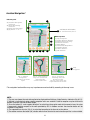
Latitude and longitude, expressed as angles, can be represented in different formats,
which in VDO GP7 are:
DDD° MM’ SS.SS’’ Degrees Minutes seconds
DDD.DDDDDDDDD Decimal Degrees
DDD MM.MMMM; Degrees Decimal minutes
Cartesian System
The cartographic representation on a map requires to project the datum assumed as a
reference for Earth on a plane surface. The projection then transforms the geographical
coordinates of a point into plan Cartesian coordinates. Each projection implies a distortion
transforming an ellipsoidal surface into a plane one.
Among the various transformations available, the conformal transformations are quite
used, because they have the property to maintain the angles between the ellipsoid and the
plane, and so the shape for small areas. On the other hand the conformal transformations
distort the distances so that the distance between two points of the ellipsoid is different
from the distance measured between the same two points projected on the plane.
Nevertheless it is possible to estimate the ellipsoid distance using formulas derived from
ellipsoidic geometry or using the Euclideian distance on a plan corrected by an appropriate
coefficient.
In VDO GP7 the distances are offset automatically.
To reduce the distortion effect, the reference area is often subdivided into different
projection zones. In cartography, the transverse Mercatore projection is often used, that is
a cylindrical conformal transformation, which assumes a meridian as projection line.
In particular, UTM (Universal Trasverse Mercator) adopts the transverse Mercatore
projection, subdividing the globe into 60 zones of six longitude degrees each, projecting
respect to the central meridian of each zone.
The count of the zones starts from the Greenwich antimeridian proceeding to East. Because
the projection diverges to infinity at the poles, it is limited between the 84° North latitude
and 80° South latitude.
62