1
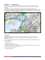
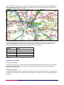
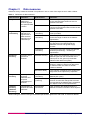
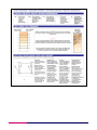
1:250 000 Scale Colour Raster
User guide
Contents
Section
Preface
Chapter 1
Chapter 2
Chapter 3
Annexe A
Annexe B
Annexe C
Page no
..................................................................................................................................................3
Contact details ..........................................................................................................................3
Use of the product.....................................................................................................................3
Purpose and disclaimer ............................................................................................................3
Copyright in this guide ..............................................................................................................4
Data copyright and other intellectual property rights ................................................................4
Trademarks ...............................................................................................................................4
Backup provision of the product................................................................................................4
Using this guide.........................................................................................................................4
Introduction .............................................................................................................................5
Applications...............................................................................................................................5
System requirements ...........................................................................................................6
Supply and formats ..............................................................................................................7
Key features.............................................................................................................................8
Scale ....................................................................................................................................8
Coverage .............................................................................................................................8
Source of 1:250 000 Scale Colour Raster ...........................................................................8
Features...............................................................................................................................8
Currency ..............................................................................................................................8
Resolution ............................................................................................................................8
Georeferencing ....................................................................................................................8
Data compression ................................................................................................................8
Image compression..............................................................................................................9
Lossless compression .........................................................................................................9
Lossy compression ..............................................................................................................9
TIFF .....................................................................................................................................9
Revision ...............................................................................................................................9
Data Measures.......................................................................................................................10
Case studies ..........................................................................................................................11
Creating the right environment for data management ............................................................11
The Welsh Environmental Data Interface (WENDI) ..........................................................11
Transport Direct ......................................................................................................................11
Underpinning multi-mode transport services .....................................................................11
Metadata.................................................................................................................................12
Product and service performance report form ..................................................................13
v2.2 – 5/2009
D05300_17
1:250 000 Scale Colour Raster user guide contents v2.2 – 5/2009 © Crown copyright Page 2 of 28
Preface
This user guide (hereafter referred to as the guide) is designed to provide an overview of 1:250 000 Scale
Colour Raster (hereafter referred to as the product) and it gives guidelines and advice on how a customer
might derive the maximum benefit from the product. It assumes a general knowledge of geographic
information. If you find an error or omission in this guide, or otherwise wish to make a comment or
suggestion as to how we can improve the guide, please contact us at the address shown below under
contact details or complete the product and service performance report form at annexe C and return it to us.
Contact details
Our Customer Service Centre will be pleased to deal with your enquiries:
Customer Service Centre
Ordnance Survey
Romsey Road
SOUTHAMPTON
SO16 4GU
General enquiries (calls charged at local rate): 08456 05 05 05
Dedicated Welsh Language HelpLine: 08456 05 05 04
Textphone (deaf and hard of hearing users only please): +44 (0) 23 8079 2906
Email: [email protected]
or visit the Ordnance Survey website at: www.ordnancesurvey.co.uk
This document has been screened in accordance with the requirements set out in Ordnacne Survey’s
Equality scheme. If you have difficulty reading this information in its current format and would like to find out
how to access it in a different format (Braille, large print, computer disk or in another language) please
contact us on: +44 (0)8456 05 05 05.
Use of the product
The terms and conditions upon which the product, including this guide, is made available to you and your
organisation are contained in the customer contract made between you and Ordnance Survey. If there is an
inconsistency between the terms of your customer contract and this guide, then the terms of your customer
contract prevail. If you or your organisation has not signed a valid current customer contract then you are not
entitled to use the product.
Purpose and disclaimer
This guide is provided for guidance only and does not constitute any warranty, representation, undertaking,
commitment or obligation (express or implied) about the product or its suitability for any particular or intended
purpose. Any warranties, representations, undertakings, commitments and obligations given by
Ordnance Survey about the product and/or its suitability for any particular or intended purpose are set out in
your customer contract. It is your responsibility to ensure that this product is suitable for your intended
purpose.
Ordnance Survey does not accept any liability (whether for breach of contract, negligence or otherwise) for
any loss or liability you or any third party may suffer in relying on this guide and any guidance, suggestion,
advice or explanation provided in it. Any liability that Ordnance Survey has to you in relation to the product,
its supply, use, accuracy, data supplied, functionality or any other liability arising out of or in connection with
the product is limited as set out in your customer contract.
We may change the information in this guide at any time without notice.
We do not accept responsibility for the content of any third party websites referenced or accessed in or
through this guide, any contractual documentation, and/or the Ordnance Survey website.
1:250 000 Scale Colour Raster user guide preface v2.2 – 5/2009 © Crown copyright Page 3 of 28
Copyright in this guide
This guide (including for the avoidance of doubt any mapping images reproduced herein), is
© Crown copyright 2009. All rights reserved.
Any part of this guide may be copied for use internally in your organisation or business so that you can use
the product for the purpose for which it is licensed to your organisation or business (but not otherwise).
No part of this guide may be reproduced or transmitted in any form or by any means (including electronically)
for commercial exploitation without the prior written consent of Ordnance Survey.
No part of this guide may be copied or incorporated in products, services or publications that you generate
for onward sale, or as free promotional or support materials, without the prior written consent of
Ordnance Survey.
Data copyright and other intellectual property rights
The Crown (or, where applicable, Ordnance Survey’s suppliers) owns the intellectual property rights in
Ordnance Survey digital map data.
Full details of the terms and conditions under which Ordnance Survey digital map data may be processed
and/or manipulated or copied by a customer – whether or not for use on PCs or workstations or for making
hard copies – are available from the Customer Service Centre, please see contact details. You should check
the terms and conditions with us before using the data. It is also the responsibility of the holder of the digital
map data to ensure that any plotted or printed output contains the required copyright and database
acknowledgements in a conspicuous position.
Trademarks
Ordnance Survey, the OS Symbol, and Land-Line are registered trademarks of Ordnance Survey, the
national mapping agency of Great Britain.
Adobe and Acrobat Reader are registered trademarks of Adobe Systems Incorporated.
ArcInfo, ArcView and ESRI are registered trademarks of Environmental Systems Research Institute Inc.
MapInfo is a registered trademark of MapInfo Corporation.
Microsoft is a registered trademark of Microsoft Corporation.
Unisys is a registered trademark of Unisys Corporation.
Backup provision of the product
You are advised to copy the supplied data to a backup medium.
Using this guide
The documentation is supplied in portable document format (PDF) only. Free Adobe® Acrobat Reader®
software, which displays the guide, incorporates search and zoom facilities and allows you to navigate
within. Hyperlinks are used to navigate between associated parts of the guide and to relevant Internet
resources by clicking on the blue hyperlinks and the table of contents.
If you are unfamiliar with any words or terms used and require clarification please refer to the glossary at the
end of the document.
1:250 000 Scale Colour Raster user guide preface v2.2 – 5/2009 © Crown copyright Page 4 of 28
Chapter 1
Introduction
Ordnance Survey’s 1:250 000 Scale Colour Raster product, available in various formats (see technical
specification), provides entry-level, small-scale mapping suitable for overlaying with individual business
information.
It is derived from road maps production data, resulting in high-quality image and resolution. The
1:250 000 Scale Colour Raster is available as either full national coverage (providing an excellent overview
of the country), or as England, Scotland or Wales separately. Figure (1) shows an extract of 1:250 000 Scale
Colour Raster for the area around the Severn estuary.
Figure (1): 1:250 000 Scale Colour Raster; Bristol and the Severn Estuary
Applications
1:250 000 Scale Colour Raster combines roads, railways and other key features, providing the ideal
geographic context, either to a customer’s own geographic/business data overlaid on top or used in
applications on its own.
As 1:250 000 Scale Colour Raster is aimed at professional/business markets, its graphic specification can
provide assistance with:
• route planning;
• geographic context; and
• enhancing an Intranet or Internet site.
1:250 000 Scale Colour Raster is supplied with a 1:250 000 scale gazetteer, which lists over 25 000 place
names and a digital legend (key) providing a useful:
• place name location finder; and
• reference resource tool.
1:250 000 Scale Colour Raster user guide chapter 1 v2.2 – 5/2009 © Crown copyright Page 5 of 28
Figure (2) below shows an extract of 1:250 000 Scale Colour Raster for the area around the Salisbury area,
with the gazetteer entries shown by inserting the National Grid coordinates supplied in the gazetteer and
symbolising them with a ‘map pin’ symbol.
Figure (2): 1:250 000 Scale Colour Raster and gazetteer.
The gazetteer supplies the customer with four categories, or attributes, of information. They are the place
name, the administrative area within which it lies and National Grid references. As an example of the
contents of the gazetteer, the information for Salisbury is shown in table (1).
Attribute
Name
Value
Salisbury
County
WILTSHIRE
Easting
414,940
Northing
129,700
Table (1)
System requirements
Computer hardware
This product may be used on a wide range of hardware platforms (provided sufficient memory and storage
facilities are available), varying from desktop PCs using GIS to mainframe computers with specialised
translators and applications.
Computer software
1:250 000 Scale Colour Raster is supplied as inert data and does not include software for data manipulation.
To exploit fully the potential of 1:250 000 Scale Colour Raster it is necessary to use appropriate application
software.
1:250 000 Scale Colour Raster user guide chapter 1 v2.2 – 5/2009 © Crown copyright Page 6 of 28
Supply and formats
The data is supplied on CD and is updated and released annually in June. It is supplied as full national
coverage or as England, Scotland or Wales separately.
1:250 000 Scale Colour Raster is supplied in two tagged image file formats (TIFFs);
• TIFF Uncompressed (RGB 256 colours); and
• TIFF with LZW* compression (RGB 256 colours).
If LZW compressed formats are used then registration may be required. Guidance on the Unisys® is
available on the Unisys website at www.unisys.com/about__unisys/lzw
Customers are advised to contact their system suppliers to ensure that their software can support this mode
of compression before placing an order.
1:250 000 Scale Colour Raster user guide chapter 1 v2.2 – 5/2009 © Crown copyright Page 7 of 28
Chapter 2
Key features
Scale
1:250 000 Scale Colour Raster is designed to be nominally viewed at 1:200 000 scale.
Coverage
Great Britain (England, Scotland and Wales)
Source of 1:250 000 Scale Colour Raster
1:250 000 Colour Raster is derived from the 1:250 000 scale topographical digital database.
Features
• Shows all cities, towns and many villages as well as features in the Ordnance Survey Road Map series,
including all motorways and A and B roads, enabling simple route planning.
• High resolution for excellent image clarity.
• Supplied with a 1:250 000 scale gazetteer (text file) and digital (PDF) legend (key) to help find place
names and locations.
Currency
1:250 000 Scale Colour Raster data is derived from the latest available version of Ordnance Survey’s
databases. The 1:250 000 Scale Colour Raster dataset is refreshed annually.
Resolution
Each data tile is converted into a raster tile at a resolution of 10 dots per mm (dpmm) – 254 dots per inch
(dpi) and a pixel is 25 metres on the ground. This resolution maintains the necessary clarity of text.
Georeferencing
To be able to view each tile in the correct geographic relation to the National Grid and to each other, the tiles
must be georeferenced. GIS typically provide georeferencing as part of their functionality, but for each set of
tiles it is necessary to provide the information on how the tiles should be ordered.
Ordnance Survey provides this information in a set of georeferencing files, also known as world files. A
complete set for 1:250 000 Scale Colour Raster is available to download free of charge from the
1:250 000 Scale Colour Raster product page on the Ordnance Survey website; these are also supplied with
the product written to CD.
There is more than one type of world file. Prior to downloading one of the sets, customers are advised to
check with their system suppliers to find out which type their system supports.
The conventions behind the files’ creation can be found in chapter 3 of the technical specification. By using
the conventions outlined there, this means that other datasets using the same conventions can be imported
into the same GIS to add value to the raster map. So, for example, overlaying a routing or logistics network
over the map or displaying a customer’s demographic information.
The georeferencing files should be saved in the same directory as the files of the map tiles themselves.
Data compression
TIFF data volumes are influenced by the level of data compression. The table below shows the various sizes
by area supplied.
1:250 000 Scale Colour Raster user guide chapter 2 v2.2 – 5/2009 © Crown copyright Page 8 of 28
Storage volumes are approximate:
Great Britain
England
Scotland
Wales
(56 tiles)
(29 tiles)
(26 tiles)
(8 tiles)
Uncompressed
448 Mb
416 Mb
128 Mb
Compressed
128 Mb
52 Mb
25 Mb
There are overlaps for England, Scotland and Wales and this
accounts for a total number of tiles for all three countries as 62.
Image compression
When an image is compressed the data is analysed; duplicated data can be removed or saved in a shorter
form as part of the compression process and therefore reducing a file’s size. For example, if large areas of
water are the same tone, only the value for one pixel needs to be saved, together with the locations of the
other pixels with the same colour. When the image is edited or displayed, the compression process is
reversed. When raster is compressed, not only are the data volumes reduced but the user can download,
display, edit and transfer images more quickly.
There are two forms of compression: lossless and lossy.
Lossless compression
As its name suggests, lossless compression does not lose information within an image. A lossless
compression retains the original quality of an image when it is uncompressed. This process doesn’t provide
much compression, so file sizes remain large. Lossless compression is used mainly where detail is
important, such as when planning to make large prints.
Lossy compression
This process degrades images to some degree, meaning that the decompressed image isn't quite the same
as the original. The more an image is compressed, the more degraded it becomes. In many situations, such
as posting images on the Internet or printing small- to medium-sized prints, the image degradation isn’t so
obvious. If a lossy compressed image is over-enlarged the degradation will become apparent.
TIFF
TIFF is one of the most commonly used lossless image formats. TIFF is primarily designed for raster data
interchange and is supported by numerous image-processing applications. This permits much more efficient
access to very large files that have been compressed.
Revision
The 1:250 000 Scale Colour Raster master dataset is updated and released annually in June.
1:250 000 Scale Colour Raster user guide chapter 2 v2.2 – 5/2009 © Crown copyright Page 9 of 28
Chapter 3
Data measures
Ordnance Survey measures the data in its products in one or more of the ways set out in table 3 below.
Table 3
Definitions of data measures
Data measure
Definition
Sub-measure
Definition
Completeness
Presence and
absence of
features against
the specified data
content*
Omission
Features representing objects that conform
to the specified data content but are not
present in the data
Commission
Features representing objects that do not
conform to the specified data content but are
present in the data
Conceptual
consistency
How closely the data follows the conceptual
rules (or model)
Domain
consistency
How closely the data values in the dataset
match the range of values in the dataset
specification
Format consistency
The physical structure (syntax): how closely
the data stored and delivered fits the
database schema and agreed supply
formats
Topological
consistency
The explicit topological references between
features (connectivity) – according to
specification
Absolute accuracy
How closely the coordinates of a point in the
dataset agree with the coordinates of the
same point on the ground (in the British
National Grid reference system)
Relative accuracy
Positional consistency of a data point or
feature in relation to other local data points
or features within the same or another
reference dataset
Geometric fidelity
The ‘trueness’ of features to the shapes and
alignments of the objects they represent*
Temporal
consistency
How well ordered events are recorded in the
dataset (life cycles)
Temporal validity
(currency)
Validity of data with respect to time: the
amount of real-world change that has been
incorporated in the dataset that is scheduled
for capture under current specifications
Classification
correctness
How accurately the attributes within the
dataset record the information about objects*
Logical
consistency
Positional
accuracy
Temporal
accuracy
Thematic
accuracy
(attribute
accuracy)
Degree of
adherence to
logical rules of
data structure,
attribution and
relationships
Accuracy of the
position of
features
Accuracy of
temporal
attributes and
temporal
relationships of
features
Classification of
features and their
attributes
*When testing the data according to the dataset specification against the ‘real world’ or reference dataset.
1:250 000 Scale Colour Raster user guide chapter 3 v2.2 – 5/2009 © Crown copyright Page 10 of 28
Annexe A
Case studies
Creating the right environment for data management
The Welsh Environmental Data Interface (WENDI)
Agriculture, forestry and woodland account for 90% of Wales’ land use. Generating a wealth of insightful
statistical information. The National Assembly for Wales uses this data to inform policy, assist decision
making and help deliver a wide range of services to rural communities Read more at:
www.ordnancesurvey.co.uk/oswebsite/business/casestudies/pdf/welsh-environment-data-interface.pdf
Transport Direct
Underpinning multi-mode transport services
Transport Direct is the first ever web portal giving instant access to comprehensive journey information by
both public and private transport across Great Britain. It includes a journey planner, maps, live travel
information and onward links to coach and rail fares and ticketing services from different travel retailers. As it
develops, the portal will also incorporate services such as information on hotels, restaurants and other points
of interest. Read more at:
www.ordnancesurvey.co.uk/oswebsite/products/osmastermap/layers/itn/casestudies/TransportDirectcasestudy.pdf
1:250 000 Scale Colour Raster user guide annexe A v2.2 – 5/2009 © Crown copyright Page 11 of 28
Annexe B
Metadata
ISO 19115 compliant UK GEMINI discovery level metadata is provided for the data and can be found on the
GIgateway® (www.gigateway.org.uk).
The following is a detailed description of the metadata elements that are provided on the GIgateway:
Title: The title of the product.
Abstract: The abstract gives a brief description of the product.
Currency: The currency takes the form of date of last update for the feature.
Lineage: The lineage metadata takes the form of product specification name and date of product
specification.
Spatial extent: The spatial extent is supplied in the form of geographic identifiers (for example, England,
Scotland and Wales) and in the form of geographic coordinates.
Spatial reference system: The spatial reference system for all products takes the form of a British National
Grid system, namely OSGB36®.
Data format: Data format takes the form of the name of the format or formats the product is supplied in.
Frequency of updates: Frequency of update takes the form of a stated period of time.
Distributor contact details: Distributor contact details include with postal address, phone number, fax
number, email address and website.
Data originator: Given as the company having primary responsibility for the intellectual content of the data
source; in all cases this will be Ordnance Survey.
Other metadata available includes keywords, start date of data capture, access constraints, use constraints,
level of spatial data, supply media and presentation details.
1:250 000 Scale Colour Raster user guide annexe B v2.2 – 5/2009 © Crown copyright Page 12 of 28
Annexe C
Product and service performance report form
Ordnance Survey welcomes feedback from its customers about 1:250 000 Scale Colour Raster.
If you would like to share your thoughts with us, please print a copy of this form and when completed post or
fax it to the address below.
Your name: ..........................................................................................................................................................
Organisation: .......................................................................................................................................................
Address: ...............................................................................................................................................................
..............................................................................................................................................................................
..............................................................................................................................................................................
Postcode: .............................................................................................................................................................
Phone: .................................................................................................................................................................
Fax: ......................................................................................................................................................................
Email: ...................................................................................................................................................................
Quotation or order reference: ..............................................................................................................................
Please record your comments or feedback in the space below. We will acknowledge receipt of your form
within three (3) working days and provide you with a full reply or a status report within 21 working days.
If you are posting this form, please send it to:
1:250 000 Scale Colour Raster Product Manager, Ordnance Survey, Romsey Road, SOUTHAMPTON,
SO16 4GU.
If you wish to return it by fax, please dial 023 8079 2615.
Any personal information that you supply with this report form will be used by Ordnance Survey only in the
improvement of its products and services. It will not be made available to third parties.
1:250 000 Scale Colour Raster user guide annexe C v2.2 – 5/2009 © Crown copyright Page 13 of 28
1:250 000 Scale colour Raster
Technical specification
Contents
Section
Introduction
Chapter 1
Chapter 2
Chapter 3
Annexe A
Page no
................................................................................................................................................15
Purpose of this specification and disclaimer...........................................................................15
Copyright in this specification .................................................................................................15
Data copyright and other intellectual property rights ..............................................................15
Using this specification ...........................................................................................................15
Technical................................................................................................................................16
Tiles ...................................................................................................................................16
Software/hardware requirements.......................................................................................16
Specification.......................................................................................................................16
Legend ...................................................................................................................................17
Managing 1:250 000 Scale Colour Raster files ..................................................................22
Georeferencing .......................................................................................................................22
File formats Image file directory (TIFF) ..........................................................................23
TIFF ...................................................................................................................................24
Colour image directory.......................................................................................................24
Glossary.................................................................................................................................25
v2.2 – 5/2009
1:250 000 Scale colour Raster technical specification contents v2.2 – 5/2009 © Crown copyright Page 14 of 28
Introduction
Purpose of this specification and disclaimer
This is the technical specification (hereafter referred to as the specification) applicable to the
1:250 000 Scale Colour Raster (hereafter referred to as the product) which is referred to in the Framework
Direct Licence, Specific Use Framework Partner Licence or your other customer contract for the product.
We may change the information in this specification at any time, giving you the notice period specified in the
customer contract made between you and Ordnance Survey.
We do not accept responsibility for the content of any third party websites referenced or accessed in or
through this specification, any other contractual documentation, and/or the Ordnance Survey website.
Copyright in this specification
This specification, (including for the avoidance of doubt any mapping images reproduced herein), is
© Crown copyright 2009. All rights reserved.
Any part of this specification may be copied for use internally in your organisation or business so that you
can use 1:250 000 Scale Colour Raster for the purpose for which it is licensed to your organisation or
business (but not otherwise).
No part of this specification may be reproduced or transmitted in any form or by any means (including
electronically) for commercial exploitation without the prior written consent of Ordnance Survey.
No part of this specification may be copied or incorporated in products, services or publications that you
generate for onward sale, or as free promotional or support materials, without the prior written consent of
Ordnance Survey.
Data copyright and other intellectual property rights
The Crown (or, where applicable, Ordnance Survey’s suppliers) owns the intellectual property rights in
Ordnance Survey digital map data.
Full details of the terms and conditions under which Ordnance Survey digital map data may be processed
and/or manipulated or copied by a customer – whether or not for use on PCs or workstations or for making
hard copies – are available from the Customer Service Centre, please see contact details. You should check
the terms and conditions with us before using the data. It is also the responsibility of the holder of the digital
map data to ensure that any plotted or printed output contains the required copyright and database
acknowledgements in a conspicuous position.
Using this specification
The documentation is supplied in portable document format (PDF) only. Free Adobe® Acrobat Reader®
software, which displays the specification, incorporates search and zoom facilities and allows you to navigate
within. Hyperlinks are used to navigate between associated parts of the specification and to relevant Internet
resources by clicking on the blue hyperlinks and the table of contents.
1:250 000 Scale colour Raster technical specification introduction v2.2 – 5/2009 © Crown copyright Page 15 of 28
Chapter 1
Technical
Ordnance Survey’s 1:250 000 Scale Colour Raster product is based on the Road Maps series database. The
product is supplied as 100 km by 100 km colour tiles at high resolution for excellent image clarity. It benefits
from increased clarity and accuracy of detail, as well a greater degree of currency across the series, which
has enabled the production of an edgematched* database. The features include clear detail on all
motorways, A and B roads, all cities, towns and many villages.
* Map features that occur at the edge of tiles are adjusted to align with their correspondent part on the
adjacent tile. This means when a map area falls over two or more tiles, the map is complete or
‘edgematched.’ Principal communication features (motorways, ‘A’ roads, railways, major rivers) are
edgematched across tiles.
Place names and locations can be identified using the 1:250 000 scale gazetteer and digital legend supplied
with the 1:250 000 Scale Colour Raster.
Tiles
Because digital maps frequently cover very large areas, they are split down into squares known as tiles,
each of which covers part of the overall area.
Software/hardware requirements
1:250 000 Scale Colour Raster data is inert and requires software to maximise its full potential.
Ordnance Survey does not specify hardware requirements as it is dependent on the software and applications
within which the data will be used. Customers should contact their system or software supplier for advice.
Specification
Specification
1:250 000 Scale Colour Raster
Data source
Road Maps production data
Number of tiles
56 (edgematched)
Tile size
100 km by 100 km
Resolution
254 dots per inch or 100 dots per centimetre
Data structure
Raster
Transfer formats
TIFF Palette 8 bit (256 colours) Uncompressed
TIFF Palette 8 bit (256 colours) with LZW compression
Storage volumes
are approximate
Uncompressed
(RGB 256
colours)
Great Britain
880 Mb
England
448 Mb
Scotland
416 Mb
Wales
128 Mb
Compressed
(RGB 256
colours)
Great Britain
128 Mb
England
78 Mb
Scotland
52 Mb
Wales
25 Mb
Update frequency
Annual June
Specification
1:250 000 scale gazetteer
Data source
1:250 000 scale topographic data
Data structure
ASCII list (table format, four columns: settlements; admin area; eastings
and northings, six-figure reference)
Transfer formats
Text file
Storage volumes
1.04 Mb (48 000 names approx)
1:250 000 Scale colour Raster technical specification chapter 1 v2.2 – 5/2009 © Crown copyright Page 16 of 28
Chapter 2
Legend
1:250 000 Scale colour Raster technical specification chapter 2 v2.2 – 5/2009 © Crown copyright Page 17 of 28
1:250 000 Scale colour Raster technical specification chapter 2 v2.2 – 5/2009 © Crown copyright Page 18 of 28
1:250 000 Scale colour Raster technical specification chapter 2 v2.2 – 5/2009 © Crown copyright Page 19 of 28
1:250 000 Scale colour Raster technical specification chapter 2 v2.2 – 5/2009 © Crown copyright Page 20 of 28
1:250 000 Scale colour Raster technical specification chapter 2 v2.2 – 5/2009 © Crown copyright Page 21 of 28
Chapter 3
Managing 1:250 000 Scale Colour Raster files
Georeferencing
Georeferencing files allow tiles of map data to be located in their correct geographic position when loaded
into a geographical information system (GIS). This is achieved by loading in files alongside the data files that
contain the National Grid corner coordinates for each 100 km by 100 km tile. This is especially useful if more
than one tile of data is being loaded at once, as it allows for a true geographic depiction of the data.
When 1:250 000 Scale Colour Raster is supplied to customers it is not georeferenced in any way. The
implications of this are that tiles will not be set up in geographic relationship to each other when loaded into a
GIS.
A definition for registering raster images within a geographic framework is the process of assigning map
coordinates to the raster image data and resampling the pixels of the image to conform to the map projection
grid. This allows tiles of map data to be located in their correct geographic position relative to the map
projection and also to themselves.
Great Britain is surveyed and mapped using the Transverse Mercator (or Gauss-Kruger) projection, so all
raster tiles will be mapped to this projection as it applies to Ordnance Survey National Grid if using World or
TAB files supplied by Ordnance Survey.
Within the MIF record header the following information will be found under COORDSYS:
CoordSys Earth Projection 8, 79, "m", -2, 49, 0.9996012717, 400000, -100000 Bounds
(4.17232513428e-011, 7.7486038208e-011) (700000, 1300000)
This information relates to the Transverse Mercator projection, its position relative to the rest of the world and
also an individual tile’s position relative to the projection. The record header is constructed as (not all fields
have to be used):
CoordSys Earth Projection 8
the 8 relates to a MapInfo® identifier, in this case the Transverse Mercator
projection.
79
a MapInfo identifier, in this case this relates to Ordnance Survey of
Great Britain 1936, Airy ellipsoid.
“m”
relates to the unit of measurement, in this case metres.
-2
this is the origin of the projection in respect of longitude.
49
this is the origin of the projection in respect of latitude.
0.9996012717
indicates the distortion of the tile at the central meridian. A value of 1.0
would indicate no distortion at all. However, distortion within this
projection is minimal, even at the far western or eastern limits.
400000, -100000
these figures indicate the false origin of the British National Grid. They
represent the south-west corner of the Transverse Mercator projection,
which overlays Great Britain, so all coordinates for any tile, no matter
what scale, will always be positive.
Bounds: (4.17232513428e011, 7.7486038208e-011)
these values represent the minimum bounding X and Y coordinates for
the tile.
(700000, 1300000)
these values represent the maximum bounding X and Y coordinates for
the tile.
TIFF World Files (TWF) can be downloaded from www.ordnancesurvey.co.uk/productpages/250kraster and
used to georeference 1:250 000 Scale Colour Raster in ESRI® ArcView® and ArcInfo®. Also available are the
TAB files for use with MapInfo.
Please note there are some World Files available that contain only sea, therefore there is no data available.
These World Files have been created to allow customers to complete the coastline.
For LZW compressed formats you may need to acquire a licence for LZW. Unisys® owns the rights to the
LZW format and levies a charge for its use in GIS. Some software suppliers license LZW for use in their
products, others expect the ‘end-user’ to license LZW separately by buying a plug-in.
Further information can be obtained from the Unisys website at www.unisys.com/about__unisys/lzw/
1:250 000 Scale colour Raster technical specification chapter 3 v2.2 – 5/2009 © Crown copyright Page 22 of 28
File formats
Image file directory (TIFF)
The Image file directory for TIFF will contain the following entries:
Tag 254 (NewSubfileType)
An indication of the kind of data contained in this sub-file, for example, value = 0
Tag 256 (ImageWidth)
The number of columns in the image, the number of pixels per row, for example, value = 4000
Tag 257 (ImageLength)
The number of rows of pixels in the image, for example, value = 4000
Tag 258 (BitsPerSample)
Number of bits per component, for example, value = 8
Tag 259 (Compression)
Compression scheme used on the image data, for example, value = 5 (LZW)
Tag 262 (Photo.Interpretation)
The colour space of the image data, for example, value = 3 (RGB Palette).
Tag 270 (ImageDescription)
Value = 1:250 000 TILE HY.TIF
Tag 273 (StripOffsets)
For each strip, the byte offset of that strip,
for example, first four values = 2333 4615 6690 8765
Tag 278 (RowsPerStrip)
The number of rows in each strip, for example, value = 65
Tag 279 (StripByteCounts)
For each strip, the number of bytes in that strip after compression,
for example, first four values = 2282 2075 2075 2075
Tag 282 (XResolution)
The number of pixels per resolution unit in the image width, for example, value = 254/1
Tag 283 (YResolution)
The number of pixels per resolution unit in the image length, for example, value = 254/1
Tag 296 (ResolutionUnit)
Units used for resolution, for example, value = 2 (Inch)
Tag 306 (DateTime)
Date and time of image creation, for example, value = 2006:05:15 08:49:41
Tag 320 (ColorMap)
First four values = 15163 15163 14649 15163
Tag 33432 (Copyright)
Copyright notice, for example, value = ORDNANCE SURVEY CROWN COPYRIGHT 2006
NOTE: The values given above are relevant to 1:250 000 Scale Colour Raster data.
1:250 000 Scale colour Raster technical specification chapter 3 v2.2 – 5/2009 © Crown copyright Page 23 of 28
TIFF
Colour image directory
Tag number
File byte order:
Magic number:
Number of fields in IFD:
NewSubfileType
ImageWidth
ImageLength
BitsPerSample
Compression
Photo.Interpretation
Image description
XResolution
YResolution
ResolutionUnit
DateTime
Copyright
254
256
257
258
259
262
270
282
283
296
306
33432
TIFF 8-bit
uncompressed
II (Little-endian)
42
16
0
4000
4000
8
1
(Uncompressed)
3 (RGB Palette)
1:250 000 TILE HY.TIF
254/1
254/1
2 (Inch)
2006:05:15 09:43:20
TIFF 8-bit
LZW compressed
II (Little-endian)
42
16
0
4000
4000
8
5
(LZW)
3 (RGB Palette)
1:250 000 TILE HY.TIF
254/1
254/1
2 (Inch)
2006:05:15 08:49:41
ORDNANCE SURVEY
CROWN COPYRIGHT
2006
ORDNANCE SURVEY
CROWN COPYRIGHT
2006
The tag values listed in the above table are relevant to 1:250 000 Scale Colour Raster data.
It should be noted that customers can access tag information from a TIFF raster file by opening an image in
Microsoft® Office Document Imaging and by right clicking on the data image and looking at page properties.
By doing so, the image parameters are displayed, which relate to the tags in a TIFF file and are reflected in
the table above.
1:250 000 Scale colour Raster technical specification chapter 3 v2.2 – 5/2009 © Crown copyright Page 24 of 28
Annexe A
Glossary
accuracy
The closeness of the results of observations, computations or estimates to the true values or the values
accepted as being true. Accuracy relates to the exactness of the result, and is the exactness of the operation
by which the result is obtained.
boundary
A boundary is the limit of a predefined and established area whose limit is determined by one or more lines,
for example, county area boundary and DLUA boundary.
byte
A unit of computer storage of binary data, usually comprising 8 bits, equivalent to a character. Hence
megabyte (Mb) and gigabyte (Gb).
CAD
Computer-aided design
character
A distinctive mark; an inscribed letter; one of a set of writing symbols.
character code
The binary representation of a single element of a character set, for example, EBCDIC, ASCII.
compact disc-read only memory (CD-ROM)
A data storage medium. A 12-cm disc similar to an audio CD. Ordnance Survey uses the writable CD, a
WORM (write once, read many) device. The digital bits are encoded into a vegetable dye and, once written,
cannot be erased by overwriting with subsequent data. A laser reads the disc.
coordinate pair
A coordinate pair is an easting and a northing.
coordinates
Pairs of numbers expressing horizontal distances along original axis. Alternatively, those triplets of numbers
measuring horizontal and vertical distances. Row and column numbers of pixels from raw imagery are not
considered coordinates for the purpose of the standard.
copyright
Copyright is a legal property right that enables the creator of an original work to protect it from unauthorised
use. Through the Copyright, Designs and Patents Act 1988, Crown copyright continues to subsist in all
Ordnance Survey products until the end of the period of 50 years from the end of the year in which they were
published, and in the case of data from the end of the year in which it was extracted from the
Ordnance Survey database. Crown copyright is vested in The Controller of Her Majesty’s Stationery Office,
who has delegated powers to the Director General, Ordnance Survey, for the administration of copyright in
publications and data, including the determination of terms and conditions under which permission for their
reproduction is given.
currency
An expression of the up-to-dateness of data.
customer
An organisation or individual that makes use of Ordnance Survey’s data supply facilities. This includes both
direct sales customers of Ordnance Survey as well as customers of Licensed Partners. It does not include
anyone, or any organisation, that has access to Ordnance Survey material without charge.
data
A representation of facts, concepts or instructions in a formalised manner suitable for communication,
interpretation or processing.
data capture
The encoding of data. In the context of digital mapping, this includes map digitising, direct recording by
electronic survey instruments and the encoding of text and attributes by whatever means.
1:250 000 Scale colour Raster technical specification annexe A v2.2 – 5/2009 © Crown copyright Page 25 of 28
data format
A specification that defines the order in which data is stored or a description of the way data is held in a file
or record.
data model
An abstraction of the real world that incorporates only those properties thought to be relevant to the
application or applications at hand. The data model would normally define specific groups of entities and
their attributes and the relationship between these entities. A data model is independent of a computer
system and its associated data structures. A map is one example of an analogue data model.
database
An organised, integrated collection of data stored so as to be capable of use in relevant applications, with the
data being accessed by different logical paths. Theoretically, it is application-independent, but in reality it is
rarely so.
dataset
An Ordnance Survey term for a named collection of logically related features arranged in a prescribed
manner; for example, all water features. A dataset has more internal structure than a layer and is related to
another dataset only by position.
digital
Data that is expressed as numbers (digits) in computer-readable form is said to be digital.
digital map
Any map sold by Ordnance Survey or its agents in any form; that is on computer-readable media or as hard
copy on paper and/or film or microfilm – produced mainly, or wholly, using computerised means.
digital map data
The digital data required to represent a map. The data includes not only map detail but also features header
data, map header data and management data.
dots per inch (dpi)
The resolution, or fineness, of a raster image.
eastings
See rectangular coordinates.
extent of the realm (EOR)
The external bounding lines of Land-Line® data is EOR. The Territorial Waters Jurisdiction Act 1878 and the
Territorial Waters Order in Council 1964 confirm that EOR of Great Britain as used by Ordnance Survey is
properly shown to the limit of mean low water (mean low water springs in Scotland) for the time being
(except where extended by Parliament).
feature
An item of detail within a map that can be a point or symbol, a line or text.
file
An organised collection of related records. The records on a file may be related by a specific purpose, format
or data source – the records may or may not be arranged in sequence. A file may consist of records, fields,
words, bytes, characters or bits.
font
The style of text character used by a printer or plotter.
format
The specified arrangement of data. For example, the layout of a printed document, the arrangement of the
parts of a computer instruction, the arrangement of data in a file.
geographical information system (GIS)
A system for capturing, storing, checking, integrating, analysing and displaying data that is spatially
referenced to the Earth. This is normally considered to involve a spatially referenced computer and
appropriate applications software.
1:250 000 Scale colour Raster technical specification annexe A v2.2 – 5/2009 © Crown copyright Page 26 of 28
gigabyte (Gb)
The equivalent of 1 073 741 824 bytes; a measure of data storage capacity.
grid
The planimetric frame of reference; for example, the National Grid.
hard copy
A print or plot of output data on paper or some other tangible medium.
kilobyte (Kb)
The equivalent of 1 024 bytes; a measure of data storage capacity.
map
The representation on a flat surface of all or part of the Earth’s surface, intended to be communicated for a
purpose or purposes, transforming relevant geographic data into an end-product that is visual, digital or
tactile.
map generalisation
A reduction in map detail, so that the information remains clear and uncluttered when map scale is reduced.
May also involve resampling to larger spacing and/or a reduction in the number of points in a line.
map header
Data at the start of the digital map file describing that data. It may contain information on the source and
history of the geometric data within the map and the coordinate system in use as well as holding information
essential to the management of Ordnance Survey’s digital mapping system.
map scale
The ratio between the extent of a feature on the map and its extent on the ground, normally expressed as a
representative fraction, for example, 1:1250 or 1:50 000.
megabyte (Mb)
The equivalent of 1 048 576 bytes; a measure of data storage capacity.
National Grid
A unique referencing system that can be applied to all Ordnance Survey maps of Great Britain (GB) at all
scales. It is based on 100 km squares covering the whole of GB based on a Transverse Mercator projection.
It is used by Ordnance Survey on all post-war mapping to provide an unambiguous spatial reference in GB
for any place or entity whatever the map scale.
northings
See rectangular coordinates.
pixel
In the 1:10 000 scale product a pixel is a single point represented by a square.
raster data
Attribute data expressed as an array of pixels, with spatial position implicit in the ordering of the pixels.
rectangular coordinates
Also known as X-Y coordinates and as eastings and northings. These are two-dimensional coordinates that
measure the position of any point relative to an arbitrary origin on a plane surface, for example, a map
projection, a digitising table or a VDU screen.
resolution
A measure of the ability to detect quantities. High resolution implies a high degree of discrimination but has
no implication as to accuracy. For example, in a collection of data in which the coordinates are rounded to
the nearest metre, resolution will be 1 m but the accuracy may be ±5 m or worse.
RGB
Red, green and blue colours and variations of them go to make up the colours represented in the raster data.
1:250 000 Scale colour Raster technical specification annexe A v2.2 – 5/2009 © Crown copyright Page 27 of 28
source scale
The scale of the source information from which the map was digitised; that is the scale of survey for a
basic-scale map or the scale of the source map for a derived map.
spatial data
Data that includes a reference to a two- or three-dimensional position in space as one of its attributes. It is
used as a synonym for geometric data.
stipple
Used to produce light or dark shading (for example, building/water fill); this is dependent on spacing of the
dots – the denser the dots, the darker the effect.
structured data
Data within which collections of features (of any type) form objects. Topographically structured data also
contains topological information defining the relationships between features and objects.
TIFF
TIFF is a tagged image file format-based file format for storing and interchanging raster images with the most
recent version – 6.0 – published in 1992.
topographic database
A database holding data relating to physical features and boundaries on the Earth’s surface.
topography
Topography is the study of the physical features of the Earth. A topographic map’s principal purpose is to
portray and identify the features of the Earth.
transfer format
The format used to transfer data between computer systems. In general usage, this can refer not only to the
organisation of data but also to the associated information, such as attribute codes, which are required in
order to successfully complete the transfer.
transfer medium
The physical medium on which digital data is transferred from one computer system to another, for example,
CD-ROM.
update
The process of adding to and revising existing digital map data to take account of change.
vector
A straight line joining two data points.
vector data
Positional data in the form of coordinates of the ends of line segments, points, text positions and so on.
volume
A physical unit of the transfer medium; that is a single disc.
1:250 000 Scale colour Raster technical specification annexe A v2.2 – 5/2009 © Crown copyright Page 28 of 28