1
Chapter 2
High-level product overview
Source of Meridian 2
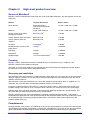
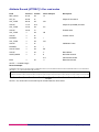
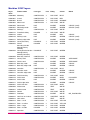
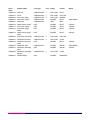
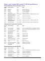
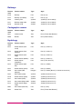
Meridian 2 data are derived from large-scale and small-scale digital databases. The data capture source and
scales are:
Feature
Original data source
Source scales
Road network
Roads centrelines
Ordnance Survey Roads
Database
1:1250, 1:2500 and 1:10 000
Railways
Large-scale database
1:1250, 1:2500 and 1:10 000
™
County, district and London
borough for England
Boundary-Line
1:10 000
Unitary authority areas for Wales
Boundary-Line
1:10 000
Unitary authority areas for
Scotland
Boundary-Line
1:10 000
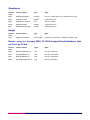
Coastline
Landranger®
1:50 000
Developed land use areas and
place names
Strategi®
1:250 000
Hydrology
Strategi
1:250 000
Woodlands
Strategi
1:250 000
Gridded height
Land-Form PANORAMA®
1:50 000
Currency
Meridian 2 data is derived from the latest available versions of Ordnance Survey’s databases. The
Meridian 2 dataset will be refreshed annually.
The large- and small-scale databases are controlled by the revision criteria for topography that are defined
by Ordnance Survey for the various geographical areas.
Accuracy and resolution
The resolution of the data supplied is 1 metre. Meridian 2 data retains the same accuracy as the source data
during its capture. However, it is not possible to calculate meaningful accuracy criteria for these data due to
different source databases.
The Ordnance Survey Road Database has a 20 m filter applied to the centreline, which is supplied to a 1 m
resolution. The 20 m filter does not affect the positional accuracy of node points.
During the updating of the road data there is a comparison buffer created – around the existing road data –
to detect change. This buffer is set to 3 m either side of a feature, 5 m at each end, and 10% of the length.
Administrative areas and roads data have a 20 m lateral filter applied to the boundary and centrelines. The
20 m filter does not affect the positional accuracy of node points.
Features derived from the small-scale databases have been subjected to generalisation – information is
cartographically represented in areas where accurate positional representation would cause confusing clutter
on the viewed image. To maintain positional relationships such data has been further adjusted to fit the
hierarchy where necessary.
Completeness
During production, many checks are undertaken to ensure that data supplied to customers are both accurate
and complete. During digital manipulation in creating the upgraded data, all sources of that data are checked
against specification documentation to identify whether any features have been omitted or misaligned.
Meridian 2 user guide chapter 2 v5.2 – 02/2007 © Crown copyright Page 8 of 93