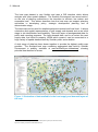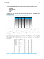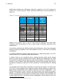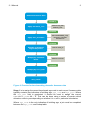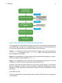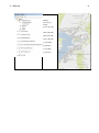
1
Scotland Heat Map User guide 2.1 Manual Version 1.0 April 2014 Initial Methodology Report prepared by Carbon Trust Resources and Ramboll Energy for the Scottish Government. The Carbon Trust Forsyth House 93 George Street Edinburgh EH2 3ES Scotland Ramboll Energy Hudson House 8 Albany Street Edinburgh EH1 3QB Heat, Energy Efficiency and Low Carbon Investment Energy & Climate Change Directorate Scottish Government Victoria Quay Area 1 D South EDINBURGH EH6 6QQ e-mail: web: [email protected] www.scotland.gov.uk/heatmap © Crown Copyright 2014 Applications for reproduction of any part of this publication should be addressed to the above address. This report is published electronically to limit the use of paper, but photocopies will be provided on request to Heat, Energy Efficiency and Low Carbon Investment . 2.0 Methodology report Description 2 28/04/14 Sophie Schorah Crispin Matson Paul Steen Report and Manual Ref. 61032638 Revision Date Made by Checked by Approved by Ramboll Hudson House 8 Albany Street Edinburgh EH1 3QB www.ramboll.com/energy 2.1 Manual Contents 1. 1.1 1.2 1.3 2. 2.1 2.2 2.3 2.4 3. 3.1 3.2 3.3 3.4 3.5 3.6 3.7 3.7.1 3.7.2 3.8 3.9 3.9.1 3.10 3.11 3.12 3.13 3.14 3.15 3.16 4. 4.1 4.2 4.3 4.4 4.5 4.6 4.7 4.8 4.8.1 4.8.2 Introduction 2 Scotland heat map – user guide 2 Why develop a heat map? 2 Structure of the Manual 4 Importing the Scotland heat map 5 Importing the heat map to a local system 5 Heat Map Contents 6 Software 8 Methodology Overview 9 Data gathering, review and modification 10 Data Management 10 Requests for Data 11 Generating the Heat Demand Layer 12 Establish Confidence Levels 13 Establish Calculation Codes 13 Calculating Building Footprints from AddressBase (MM_AREA) 14 Create Benchmark Lookup Tables 14 AddressBase Benchmarking 15 Domestic Benchmarks 16 Public Sector Energy Demand 22 Planning and Economic Development 24 Future development projections 24 Tenure 24 Heat Supply 24 District Heating Networks 27 Opportunities and Constraints 28 Layer Options 29 Additional Information 29 Utilities Layouts 29 Heat demand calculations 0 Assigning Benchmarks to AddressBase Data 1 Assigning Benchmarks to Domestic Assessor Data 1 Assigning Benchmarks to Non-Domestic Assessor Data 5 Assigning Benchmarks to Non-Domestic ePIMS Data 7 Distilleries 8 Public Sector Heat Demand Data 8 Future Heat Demand 9 Energy Supply Data 10 Role of energy supply data 24 Waste to energy plants 10 2.1 Manual 4.8.3 4.8.4 4.8.5 4.8.6 4.8.7 4.8.8 5. 5.1 5.2 6. 6.1 6.2 6.3 6.4 6.5 Wastewater Treatment Works 10 Heat generation from Coal Authority 2 Heat generation from Forestry Commission 2 Heat generation from Scotch Whisky Association (SWA) 2 Heat generation from OfGEM 2 Address Matching 0 Create final outputs 3 Preparing the GIS Maps 3 Map formatting and iconography 3 Utilising the heat map 5 National Policy 8 Strategic Planning 9 Site Identification 11 Detailed Feasibility 13 Summary of Tools 14 2.1 Manual 2 1. Introduction 1.1 Scotland heat map – user guide This document is Scotland heat map – user guide 2.1 manual. It is part of a suite of user guide for the Scotland heat map. These can be downloaded from www.scotland.gov.uk/heatmap. 2.0 2.1 2.2 2.3 2.4 Methodology report Manual Metadata, limitations and data management Local knowledge validation & improvement process Scotland heat map – interactive and local web This manual covers two areas: Creating the national dataset This focuses on the role of Scottish Government, but is useful to understand the data within the heat map and for managing local data to be used in the national heat map. This information is highlighted in purple. 1.2 Using the local datasets This focusses on the role of local authorities. It describes how to import the heat map and the methodology and calculations used to create it. It also describes each of the datasets and defines some suggested uses of the map. This information is highlighted in orange. Why develop a heat map? Heat mapping is a powerful way to visualise and assess who needs heat, where sources of heat might come from and how these can be connected in an efficient way to reduce the cost of heat supply and the carbon intensity of heat generation. It can also be used, in combination with other spatial datasets as a tool to illustrate the socio-economic benefits of changing existing paradigms of heat supply. Each Scottish local authority has been offered the heat map dataset for their area to support local energy planning. This requires acceptance of the Framework Agreement . 1 Councils starting work on their own heat map have set up working groups to manage set up and use. Typically the group has an overall lead (often from Planning or Sustainability but this is down to local choice). Other group members often included representatives from GIS, energy management, housing, economic development. A number of roles in managing and delivering the heat map outlined in Scotland heat map – Framework 2.4 organisation contact form. If an organisation plans to provide data for the Scotland heat map then they will also want to identify data owners for each data source Scotland heat map user guide – 2.2 metadata, limitations and data management. 1 www.scotland.gov.uk/heatmap 2.1 Manual 3 The heat map dataset is very flexible and uses a GIS interface which allows analysis with other spatial datasets. The Scottish Government has issued advice on the role of planning authorities in the transition to efficient, low carbon and renewable heat. This advice describes how the heat map can support planning authorities in developing policy, strategic development planning and at determination stage. 2 The heat map can be used for detailed analysis at national and local level. It allows calculation and spatial representation of heat supply and demand and as an initial stage in site identification and feasibility. There are layers of amalgamated data for public and reporting purposes. The heat demand data, and to an extent the neat supply data, are linked to property UPRN which means it can be connected to a huge variety of spatial datasets held by Scottish public sector bodies. A wide range of data has been drawn together to provide the highest quality map possible. The Scotland heat map containing aggregated data held by Scottish Government is publicly available at www.scotland.gov.uk/heatmap, showing potential heat demand of areas. Figure 1: Illustration of data available in the heat supply and demand layers of the map 2 Scottish Government Planning and Heat online renewable planning advice (Scottish Government) http://www.scotland.gov.uk/Resource/0042/00422374.pdf 2.1 Manual 1.3 4 Structure of the Manual Section 2 of the manual provides a guide on how to import and work with the Scotland Heat Map. This includes full metadata for each layer package and details of the most appropriate software to use for data handling at various stages of the process. Sections 3, 4 and 5 provide comprehensive instructions on how to generate the heat map. However these can also be useful for using the local datasets and creating data that can be fed back into the national map. Text shown in square brackets indicates a database title, for example: [HEAT_DEMAND] or [HEAT_SUPPLY]. Text shown in alternative font indicates field titles, for example: POSTCODE or HEAT_DEMAND. This alternative font is also used to show examples of SQL queries. 2.1 Manual 2. Importing the Scotland heat map 2.1 Importing the heat map to a local system 5 The heat map is developed in ESRI file-based geodatabases. Local authorities should outline advice if other formats are required. If ESRI’s desktop software is being used, installation of the heat map is very simple: 1. Copy the folder to a designated folder on the local network. On this folder user rights can be administrated as required. 2. Open the ArcMap file “HeatmapAllLayersxx.mxd”. Now all the layers should be visible in the table of content to the left as illustrated in the figure below: Figure 2: Image of the imported ArcMap file If the layers are not visible, but the headers in the table of content are marked with a red exclamation mark (see Figure 3) then the layer cannot locate the data source and a link must be created manually. If the geodatabase folder was copied to a separate local folder as described, this should not be necessary. If it is desirable to take a copy of the .mxd document to another location on a desktop or network, note that it is likely that the links will have to be re-established. 2.1 Manual 6 Figure 3: Example of layers which must be manually linked to the geodatabase If heat map must be installed in formats other than ESRI, Scottish Government can provide a set of data for most common GIS formats. If installation to a GIS server system is preferred, all the data must be uploaded and the symbology may have to be re-created for each layer. 2.2 Heat Map Contents The Scotland Heat Map is divided into nine layer groups. Each group contains data from several sources. A small number of above sub-layers have been made available only to the Scottish Government and therefore they are unavailable to other organisations. However the contact details of relevant organisation can be provided should local authorities which to set up separate data sharing agreements with these organisations. Table 1 shows the data sets contained within each layer group. Table 1: Description of layers in the Scotland Heat Map Layer Group Sub -layers Heat Demand Heat demand by property (point data) Heat demand rasters (50m, 250m, 500m & 1 km resolution. Major heat anchor loads Confidence level raster Tenure by area (Census by data zone) SFHA point data Housing association point data (where separate from SFHA) Local authority point data Suppliers point data (all technology) Wind farms (polygons) Geothermal layers Tenure Heat Supply 2.1 Manual 7 District Heating Networks Planning and Economic Development Opportunities and Constraints Layer Options Additional Utilities Layouts Coal Authority Forestry Commission Borehole Temperatures Heat Network Partnership point data EST point data SG network layouts (polylines) DH network operator layouts (polylines) Local Development plan areas Building rates for LDP area Planning permissions Building completion certificates Historic Scotland data on buildings and areas of heritage value Conservation areas Scottish Index of Multiple Deprivation Scotland boundary outline Local Authority (council) boundary outlines and names Intermediate Geography outlines Data Zone (boundary outlines and identifiers) Postcode area outlines Settlement boundaries Gas pipes (provided by SGN) A small number of above sub-layers have been made available only to the Scottish Government and therefore are unavailable to other organisations. However, the contact details of relevant organisation can be provided should local authorities which to set up separate data sharing agreements with these organisations. The Heat Demand layer group is considered to be the most important of all the heat map layer groups and is structured as shown in Table 2. Table 2: Heat Demand data layer field information Type Name GeoDB HeatDemandLyr.gdb Feature HeatDemandxxx Class (Can be called HeatDemandIntermed/Heatde mandLyr1 or similar) Fields UPRN Xcoord Ycoord CalcCode Description Geodatabase containing just this one layer The principal heat demand layer, unifying the information from the sub-layers. Rasters are based on the heat demand from this layer. The basis of this layer is the points from OS AddressBasePlus, hence most of the fields are described in the accompanying metadata-description for this product. The UPRN values, used as the fundamental join field to other datasets. X-coordinates (British National Grid) Y-coordinates (British National Grid) Code for the source of the heat demand value, i.e. the sub-layer and possibly selected parts of this, based on 2.1 Manual 8 HeatDemand BM MM_Area HD_KM2 Confidence MM_TOID SourceType GeoDB HeatDemandSubLayers.gdb Feature ActualHeatDemand class AssrDomHeatDemand AssrNonDomestic EPCHeatDemand ePIMsDemand SWAHeatDemand 2.3 availability of data. *See table 1 The heat demand value in KWH, obtained from the source of highest quality Benchmark values, used for some of the CalcCode values The area of the polygon that the point falls within in the OS Master Map product. Used as base-value in benchmarking (CalcCode=1) Correction to KWH/Year/KM2 as described in manual (HeatDemand x 0.04566) The confidence assigned to the heat demand value. The ID of the OS Master Map polygon The type of source (Domestic, nondomestic or other). Geodatabase containing the sub-layers Heat demand based on actual billing data from local authorities etc. Heat demand based on assessors domestic data Heat demand based on assessors nondomestic data Heat demand based on EPC data Heat demand based on ePIMs data Heat demand based on data from the Scottish Whisky Association Software Consideration must be given into the choice of software for: Data management Processing of databases Mapping Factors which affect the choice of software include: the size of the data set (MS Excel and MS Access may not hold records on a national scale) whether complex calculations need to be carried out (complex queries on large data sets require a lot of processing) what the final output should look like. The creation of maps for the Scotland Heat Map has been carried out using ESRI ArcGIS. Although many local authorities use ESRI ArcGIS, other packages include Smallworld, Quantum and StatMap. Data will be provided in the most common formats. 2.1 Manual 9 The heat map has been produced using various software tools. Due to the very large amount of data received in the project, standard desktop software such as MS Excel and Access has not been adequate for processing and MS SQL-server has been used as the final collecting point for most of the calculated datasets. ArcGIS desktop software with the extension “Spatial analyst” has been used for all GIS handling and map production. MS Excel and MS Access have been utilised for most of the initial data management, cleaning and merging of datasets besides calculation of benchmarks on selected datasets. MS SQL-server (SQL Express and SQL Server Professional) and Microsoft SQL Server Management Studio have been used for later data management, handling of large, merged datasets, address matching and final calculations of heat demands. 2.4 Methodology Overview The overall handling of data follows this workflow: 1. Data validation and cleaning in standard software an MS Excel, text editors and MS Access. 2. Merging of datasets to a common table setup – this in Access or on SQL server. 3. Final data cleaning and alignment of datasets. 4. Adding and updating common fields in SQL Management Studio. 5. Create feature classes in ArcGIS, based on xy-coordinates or the UPRN number from the tables. As described in user guide document 2.0 Methodology Report, the methodology for developing a heat map is a circular process. Once the final map is produced improvements and developments are made by returning to the beginning of the process. 2.1 Manual 3. 10 Data gathering, review and modification This section outlines the initial data gathering, validation and cleaning stages of creating the heat map. 3.1 Data Management Due to the high number of records provided by a multitude of sources, a strict data management procedure is essential throughout construction and maintenance of the Scotland Heat Map. As each set of information is received it should be tracked through the data processing, database structuring and mapping process. Data should be stored according to layer group and source and a thorough record must be kept of when data is received or updated. During the creation of the Scotland Heat Map, a data checklist spreadsheet was used to record the incoming data. The fields contained within the data checklist are listed in the table below: Table 3: Data checklist fields for data management Field Stakeholder Contact Details Status Information Responsible Person RFI Sent Confirmation of Receipt Request Date Data Received Received Date Data in Server Initials Data Cleaned Database Complete Link Description The name of the data provider Contact details for the data provider The level of communication with the stakeholder What data is expected to be received The organisation responsible for requesting the data Has the request been sent – Y/N? Has the stakeholder acknowledged the request? When was the data requested? Has the data been received – Y/N? When was the data received? Has the data been saved to the appropriate place? Within the organisation creating the map, who will be responsible for processing the data? Has the data been cleaned? Has a complete database been created? Hyperlink to data location (if saved on a network) All organisations providing data to the heat map have been assigned a unique reference number. These are listed in Scotland heat map user guide – 2.0 methodology report along with an indication of the data that was provided by each organisation. This reference number will be contained within a field entitled ORG_NO, which will enable the user to trace the origin of the data. Additionally the user will be able to filter the data by source and gain a clear picture of types of heat demand. In addition to the data sources listed in Scotland heat map user guide – 2.2 metadata, limitations and data management, various supplementary data sources are used in calculations to create the final heat demand figures. These include data 2.1 Manual 11 sets such as national benchmark figures and degree days and these are also included in the user guide – 2.2. The data provided for the heat map has varying conditions for use. Some is open data, some can be viewed publically but only shared at an aggregated level, and some is not available publically, but can be used for broader analysis such as statistical analysis and research. Guidance is provided in the Framework agreement and associated documents at www.scotland.gov.uk/heatmap. The heat map dataset is created from the most detailed sources of data available. However the complexity of developing a national dataset mean that there will be duplication and improvements needed. Local knowledge will be key to improving the quality of the dataset over time. There will be an initial validation and improvement period to the 31 August 2014 and then an ongoing validation and improvement process outlined in Scotland heat map user guide – 2.3 Local knowledge, validation and improvement. Ongoing data management will be required. Local updates to data will need to be fed back to into the national map update process to ensure they are incorporated. This will require standardised data management processes and schema, including standard drop down menus. The approach is outlined in Scotland heat map user guide – 2.2 metadata, limitations and data management. A systematic approach to the initial data gathering and cleaning stages is essential in delivering and updating a heat map. Data should be stored according to layer group and source and a thorough record must be kept of when data is received or updated. 3.2 Requests for Data The foundation layer of the Scotland Heat Map is the OS AddressBase. This provides the addresses and UPRNs of every property in Scotland. The Unique Property Reference Number (UPRN) is a unique number given to every building in Scotland. Every council in Scotland holds, manages and maintains a Corporate Address Gazetteer (CAG), which is a spatial dataset that provides the location of every address in the Council area with a range of relevant attribute information. A UPRN is given for every property within the CAG. As the UPRN provides a direct link to the spatial data set, it is preferable that all data sources state the UPRN for each record. Without the UPRN, address matching must be carried out using alternative fields which can be much less accurate, resulting in some data being excluded from the map. Public sector bodies are recommended to synchronise their software/databases for energy and asset management to use the UPRN. This would allow easier and more 2.1 Manual 12 robust updating of energy data. Where this has been done there have been significant benefits reported within the organisation. Building on the AddressBase is the data from the fourteen Scottish Assessors which provides more detailed information for just fewer than 3 million private properties. The information varies between Assessors, but generally includes fields such as address, building type and floor area. Data has also been provided by over 100 different organisations which they have either published or provided on request. Scottish Government would like to thank all those organisations. Future requests to local authorities for energy consumption data will come via ProcExec/ScotExed. Scottish Government would like to encourage all organisations to use the CAG UPRN as an identifier in their data. 3.3 Generating the Heat Demand Layer To begin creating the heat demand layer a copy of the AddressBase data set should be created and renamed [HEAT_DEMAND]. The Ordnance Survey AddressBase Plus data has been used as the unifying, unique address/point reference throughout the project. The Address Base data was received as four separate, large text files with a fixed column setup. Headers were downloaded from the Ordnance Survey webpage. Data was imported to SQL server and merged and a point feature class was made in ArcGIS, based on the xy-coordinates in the table. This feature class contained approximately 3.2 million records. The Master Map was received in the open standard for GIS exchange, GML. These were converted to ArcGIS Feature classes, which is not a direct conversion. Rather, the GML objects have to be assigned as points, lines and polygons and the symbology gets lost in translation. However, the main purpose of the Master map data was to use the local area polygons for assigning an area for first level benchmarking as described in Section 3.6. The AddressBase and Master Map will form the basis of the heat demand layer package and initially should contain the UPRN and full postal address in addition to any property type information for each record. Several fields must then be added to this table, which will be explained in the subsequent sections: CONFIDENCE_FACTOR CALCCODE MM_AREA BENCHMARK_HEAT HEATDEMAND In addition to these fields, several other fields will be incorporated into the table as records are superseded by those from more reliable sources, for example the indicators of age and floor areas from the Scottish Assessors. 2.1 Manual 3.4 13 Establish Confidence Levels The heat demand layer is built upwards from general national heat benchmarks applied to all properties, which are then superseded by more reliable values. The reliability of data will be represented by the allocation of a “confidence level” to all records. The confidence levels are shown in Table 5 and range from 1 – 5, where 5 represents the most reliable data. Table 4: Data sources within each confidence level Factor 1 2 3 4 5 3.5 Heat Demand Sources Benchmarking AddressBase footprints Benchmarking of Assessor and ePIMS records where some property information is unavailable Benchmarking of Assessor and ePIMS records where all required information is available EPC and SWA Public sector billing data Establish Calculation Codes Each heat demand record is assigned a calculation code which indicates the calculation method used to produce the heat demand value. The calculation code is dependent on the data source, the amount of information provided and the use of benchmarks. The following table outlines the calculation codes used for the Scotland Heat Map. Table 5: Calculation code descriptions and corresponding confidence levels Code Properties to Include 0 1 2 3 4 5 6 7 8 9 Properties where no significant heat demand is expected e.g. plots of land or public toilets. Properties where residential status is assumed from OS footprint, but no other data exists. Private non-domestic properties where data exists which categorises property as non-domestic, but no other information is available. Private domestic properties where data exists which categorises property as domestic, but no other information is available Public non-domestic properties where exists which categorises the property as public non-domestic, but no other data exists. Private domestic properties where there is data on age and type, but no floor area. Private domestic properties where there is data on age and floor area, but no property type. Private domestic properties where there is data on property type and floor area, but no age. Private non-domestic properties where there is data on floor area, but property type is unavailable. Private non-domestic properties where there is data on property Level N/A 1 2 2 2 2 2 2 2 2 2.1 Manual 14 Code Properties to Include 10 11 12 13 14 15 16 17 18 type but floor area is unavailable. Private domestic with only floor area provided Private domestic with only building type known Private domestic properties where data on age, type and floor area is available Private non-domestic properties where data on property type and floor area is available Public non-domestic properties where data on property type and floor area is available Actual domestic energy data obtained from EPCs Properties identified as distilleries Scottish Government “procurement” data Billing data from public bodies Level 2 2 3 3 3 4 4 5 5 Allocation of calculation codes is most easily done in parallel with the calculations in the form of simple update queries in the CALCCODE field. Records which are updated with a calculation are allocated the relevant code. Alternatively, codes can be allocated to records at a later stage through queries based on the data attributes. This is a more complex process as combinations of attributes may be required to correctly allocate the code. For example the calculation code 5 may only be assigned if floor area is null, but property type and age are not null and can successfully be joined with lookup tables. 3.6 Calculating Building Footprints from AddressBase (MM_AREA) Initially points must be assigned to all areas which correspond with the AddressBase records. These are then filtered to remove areas which have no heat demand, such as roads or monuments. The filter was applied by discarding all records that were not assigned as “building” or “structure” The postal_addressable field can be used to filter the data by selecting and eliminating all “N” values. The remaining records form the foundation of the heat demand feature class. Where multiple points fall on one polygon, the demand is divided by the number of points which will then make up the appropriate value when summed in the heat demand layer. 3.7 Create Benchmark Lookup Tables For the lowest three levels of confidence level (1, 2 and 3), benchmark heat demands are applied to each property. 2.1 Manual 15 Benchmarks are heat demand figures which are assigned to properties where actual demand data is unavailable. Values are typically presented in kWh/m2 and therefore floor area is required to calculate the total building demand. Benchmarks can be calculated from averages of actual demand figures using existing heat demand databases. Also, there are several national benchmark guides where data can be obtained. As the benchmarks vary by several factors including building type and building age, lookup tables should be created to enable the records to be allocated the correct benchmark using simple join queries. The benchmark heat demand values are contained within the field BENCHMARK_HEAT. 3.7.1 AddressBase Benchmarking The benchmarks at this foundation level feature the lowest confidence level and calculation code as there are two values only: domestic and non-domestic. The two figures are calculated from the domestic and non-domestic benchmark tables outlined in following sections. All buildings with a footprint less than or equal to 200 m2 is categorised as domestic and all buildings with a footprint greater than 200 m2 is categorised as non-domestic. The figures have been appropriately scaled to take outliers into consideration, based on the proportions of floor areas contained in the Scottish Assessors data. Table 6: Benchmark values allocated to OS footprints Properties with footprint ≤200 m2 Properties with footprint >200 m2 247 kWh/m2/yr 220 kWh/m2/yr The calculation required consideration of the overall average benchmarks, the proportion of properties in each category and the total number of properties in each category. These figures are presented in the three tables below and the values are taken into the subsequent equations. Average benchmark values ≤200 m² >200 m² Domestic 178 x 1.4 = 249 kWh/m² 178 x 1.4 = 249 kWh/m² Non-Domestic 194 kWh/m² 194 kWh/m² Proportion of properties in each category ≤200 m² >200 m² Domestic 95% 5% Non-Domestic 34% 66% 2.1 Manual 16 Number of properties in each category ≤200 m² >200 m² Total no. properties Domestic 2,496,955 131,419 2,628,374 Non-Domestic 74,554 144,723 219,277 Hence the benchmarks to be applied are: Properties in OS with area ≤200 m² Properties in OS with area >200 m² 3.7.2 Domestic Benchmarks Domestic benchmarks per m2 were calculated using the Scottish House Condition Survey (SHCS). Approximately 9,000 records were available comprising 3,000 records from each of the years 2010 to 2012. Domestic heat benchmarks were divided into the following age groupings: Table 7: Domestic benchmark age groupings used in the Scotland Heat Map BENCHMARK_CODE AA A B C D E AB ABC ABCDE Building Age Post 2005 1982 – 2005 1965 - 1981 1945 – 1964 1918 – 1944 Pre 1918 Assessor data states post 1966 Assessor data states post 1945 No building age in assessor data Codes A - E match the age code categories of the SHCS . AA has been added to provide space for future benchmarks to be added. At present the AA and A values are identical. 3 The three benchmark codes AB and ABC are averages of the combination of individual codes, which can be applied to data which does not state a specific year, but gives a rough indication of time period. ABCDE is an average of all ages for a specified building type and is only applied to those records which contain no information regarding age (see Calculation Code 7 in Section 4.4). 3 SHCS age categories were chosen over the Assessors age categories due to there being a higher number which results in greater accuracy. 2.1 Manual 17 The domestic heat benchmarks are also divided into four core building types: Detached Semi-detached Terrace Flat Therefore the final domestic heat benchmarking table contains 36 possible heat benchmark figures: Table 8: Domestic heat benchmark values (kWh/m2/yr) Det. AA A B C D E AB ABC ABCDE 238 238 325 385 415 432 281 316 359 Semi Det. 231 231 303 303 319 358 267 279 303 Terrace Flat 210 210 250 264 279 320 230 241 265 188 188 232 242 260 289 210 221 242 It should be noted that data sources such as the Scottish Assessors will not often use the simplified categories shown in the header row in Table 8. It is often necessary to create an additional lookup table which assigns one of the four core domestic building types to the specific building types and age codes found in the raw data. In addition the Assessors use two fields which provide an indication of building type: BUILDING_TYPE and DESCRIPTION. For example, for the creation of the Scotland Heat Map there were over 1,500 different permutations of domestic BUILDING_TYPE and DESCRIPTION. These were filtered and divided up into the four core categories and assigned a benchmark. Figure 4: Screenshot of extract from domestic benchmark lookup table 2.1 Manual 18 Domestic Degree Days Degree day factors must be applied to these heat demands based on the property location. The 20 year average degree day value from the six relevant weather stations can be used to calculate the Scottish average. The SHCS heat demands were grouped into Local Authority areas and the average was calculated. A degree day factor was then allocated based on the deviation from the degree day average. The degree day factor is a ratio of the average degree days in one region compared to another, where degree days are a measure of heating or cooling. In the case of the Scotland Heat Map, the degree day factor is the ratio of the Scottish national 20 year average degree day value and the 20 year average of the weather station closest to the property being assessed. This calculation must also take into consideration the proportion of heat demand used for hot water (which is not generally affected by environmental temperature). An example calculation of the DD Factor for South Ayrshire is shown as follows: 1. Obtain the correct degree day average South Ayrshire’s relevant weather station is Glasgow. The 20 year average degree day figure for Glasgow is approximately 2317. 2. Obtain the Scottish national degree day average The 20 year national average degree day factor is approximately 2558. 3. Calculate the % difference between the two values (2317/2558)-1 = -9% 4. Take into account the proportion of heat demand used for hot water (55% estimate) 1 + 0.55*-9% = 0.95 = DD_Factor The degree days are allocated as shown in Table 9: Table 9: Domestic degree day factors for each local authority area ASSR_NO Local Authority 01 01 01 02 02 02 03 South Ayrshire North Ayrshire Council East Ayrshire Stirling Council Falkirk Council Clackmannanshire Council Dumfries & Galloway Council DD Factor 0.948 0.948 0.948 0.948 0.948 0.948 1.091 2.1 Manual 19 ASSR_NO Local Authority 04 04 04 05 06 07 07 07 08 08 09 09 10 10 10 10 11 11 12 12 12 13 14 14 14 West Dunbartonshire Argyll and Bute Council East Dunbartonshire Fife Council Glasgow City Council Aberdeenshire Council The Moray Council Aberdeen City Council Highland Council Comhairle nan Eilean Siar North Lanarkshire Council South Lanarkshire West Lothian Edinburgh City Council East Lothian Council Midlothian Council Shetland Isles Council Orkney Council Inverclyde Council Renfrewshire Council East Renfrewshire Council Scottish Borders Council Angus Council Dundee Council Perth & Kinross Council DD Factor 0.948 0.948 0.948 0.990 0.948 1.012 1.012 1.012 0.989 0.989 0.948 0.948 0.990 0.990 0.990 0.990 0.989 0.989 0.948 0.948 0.948 0.971 0.990 0.990 0.990 Domestic Insulation Factors Factors must also be applied to account for the level of insulation in buildings as insulation significantly reduces the heat demand. The factors were calculated based on the proportion of buildings within the SHCS to have insulation and the average reduction in demand of those buildings compared to those without insulation. Table 10: Insulation factors to be applied to each local authority area Local_Authority Aberdeen City Council Aberdeenshire Council Angus Council Argyll & Bute Council Clackmannanshire Council Dumfries and Galloway Council Dundee City Council East Ayrshire Council East Dunbartonshire Council East Lothian Council East Renfrewshire Council Ins. Factor 0.709 0.611 0.633 0.647 0.615 0.592 0.709 0.599 0.616 0.641 0.632 2.1 Manual 20 Local_Authority Ins. Factor 0.769 0.577 0.640 0.628 0.782 0.603 0.719 0.628 0.593 0.631 0.647 0.591 0.633 0.684 0.629 0.602 0.643 0.655 0.641 0.713 0.621 Edinburgh City Council Comhairle nan Eilean Siar Falkirk Council Fife Council Glasgow City Council Highland Council Inverclyde Council Midlothian Council Moray Council North Ayrshire Council North Lanarkshire Council Orkney Council Perth & Kinross Council Renfrewshire Council Scottish Borders Council Shetland Islands Council South Ayrshire Council South Lanarkshire Council Stirling Council West Dunbartonshire Council West Lothian Council Non-Domestic Benchmarks Non-domestic heat benchmarks in kWh/m2/annum were obtained from CIBSE TM46 . 4 The benchmarks generally fall into 29 groups: Table 11: Non-domestic heat benchmarks (kWh/m2/yr) Group Description No Demand General office High street agency General retail Large non-food shop Small food store Large food store Restaurant Bar, pub or licensed club Hotel Cultural activities Entertainment halls Swimming pool centre Fitness and health centre 4 BENCHMARK_HEAT 0 90 70 83 128 155 79 278 263 248 150 315 848 330 “Energy Benchmarks TM46: 2008”, CIBSE, October 2008 Hyperlink:http://www.cibse.org/knowledge/cibse-tm/tm46-energy-benchmarks 2.1 Manual 21 Group Description Dry sports leisure facility Covered car park Public buildings with light usage Schools and seasonal public buildings University campus Clinic Hospital (clinical and research Long term residential General accommodation Emergency services Laboratory or operating theatre Public waiting or circulation Terminal Workshop Storage facility Cold storage BENCHMARK_HEAT 248 10 79 113 180 150 315 315 225 293 120 90 150 135 120 60 Similarly to the domestic data, records that require non-domestic benchmarking will not be divided into the above group descriptions. A unique lookup table will have to be created upon receipt of the data to correspond with the description fields in the raw data (see Figure 5). For the Scotland Heat Map, the Assessor data’s building type was indicated through three fields: BUILDING_TYPE, DESCRIPTION and SE_CATEGORY. There were over 2,700 permutations of these fields, which were manually sorted so that the correct group description could be applied. Figure 5: Screenshot of extract from non-domestic benchmark lookup table 2.1 Manual 22 As the CIBSE figures are averaged for the UK rather than just Scotland, degree day factors were taken into account based on the property location relative to the UK 20 year average of 2021. The degree days are allocated as follows: Table 12: Degree day factors for non-domestic buildings ASSR_NO Local Authority 01 01 01 02 02 02 03 04 04 04 05 06 07 07 07 08 08 09 09 10 10 10 10 11 11 12 12 12 13 14 14 14 3.8 South Ayrshire North Ayrshire Council East Ayrshire Stirling Council Falkirk Council Clackmannanshire Council Dumfries & Galloway Council West Dunbartonshire Argyll and Bute Council East Dunbartonshire Fife Council Glasgow City Council Aberdeenshire Council The Moray Council Aberdeen City Council Highland Council Comhairle nan Eilean Siar North Lanarkshire Council South Lanarkshire West Lothian Edinburgh City Council East Lothian Council Midlothian Council Shetland Isles Council Orkney Council Inverclyde Council Renfrewshire Council East Renfrewshire Council Scottish Borders Council Angus Council Dundee Council Perth & Kinross Council DD Factor 1.081 1.081 1.081 1.081 1.081 1.081 1.261 1.081 1.081 1.081 1.133 1.081 1.161 1.161 1.161 1.133 1.133 1.081 1.081 1.133 1.133 1.133 1.133 1.133 1.133 1.081 1.081 1.081 1.109 1.133 1.133 1.133 Public Sector Energy Demand Billing data obtained from the public sector is generally provided as fuel used and hence requires the application of conversion factors before it can be used in the final heat map. These should be contained within lookup tables to enable easy update in future (Table 13). 2.1 Manual 23 Additionally boiler/burner efficiencies should be applied to the fuel demand to convert it to a heat demand. These assumed efficiencies are also presented in Table 13. Table 13: Conversion and efficiency factors for public sector billing data Fuel Type Conversion Units Efficiency to kWh5 used for Heating and cooling Gas 1 0.75 Electricity 1 1 Oil 10 kWh/l 0.75 Biomass 3,806 kWh/t 0.75 Fuel Oil 12 kWh/l 0.75 Gas Oil 11 kWh/l 0.75 Kerosene 10.5 kWh/l 0.75 LPG 7 kWh/l 0.75 Coal 7,500 kWh/t 0.75 Heat 1 1 Networks Other 1 0.75 Whilst oil is a generic title for gas oil and kerosene separate rows have been included in the lookup table to cover a wider range of possible responses from stakeholders. It should be noted that the NHS provided boiler efficiencies, which were averaged across all sites and applied to the data supplied and so in this case no factoring was applied. For NHS properties the degree days are based on a base temperature of 18.5°C instead of the 15.5°C used for all other data sources. A further factor to be considered when working through public sector energy demand is that where properties have electric heating the stakeholder will often only provide the total electricity demand and not the proportion of electricity used for heating. In the Scotland Heat Map properties that have their primary heat source from electric heating are assumed to use a proportion of total electricity for heating of 0.7. The Scottish Government has committed to supporting an update of the heat map in 2015-16. Future updates of the map will require a similar strategy in order to engage with the stakeholders and to gather information from each organisation. The Scottish Government is keen to reduce the effort required from contributing organisations. To provide a secure, efficient and effective electronic data exchange, the Scottish Government has amended a web based data collection and validation tool it hosts called ProcXed. ProcXed has been expanded to allow collection and vali5 “Energy and Carbon Conversions: 2013 Update”, Carbon Trust, 2013 2.1 Manual 24 dation of any combination of site, building, heating and cooling data. This can be uploaded an upload template, via xml, or input directly to a web form. Further guidance on using ProcXed will be made available to data managers. 3.9 Planning and Economic Development 3.9.1 Future development projections Each local authority has responsibility for the preparation and maintenance of their Local Development Plan (LDP). Included in this data is Housing Land Allocations (HLA) which identify the projected dwelling numbers within residential development area in the LDP. The HLA identifies the total number of houses allocated as well as a figure identifying the number of properties to be built within the next 5 years. The HLA areas are identified as shape files in the GIS and will be assigned a heat demand density according to the projected number of properties and the following benchmark heat demand. Local Authorities are encouraged to use their own data layers. 3.10 Tenure Received tenure data is divided into two layer types: tenure by area e.g. Census data tenure by point e.g. Scottish Federation of Housing Associations data This enables the heat map user to view the proportions of tenure types over wider areas as well as at individual building level. The census data was sent with corresponding intermediate data zones which were joined with a list of all intermediate data zones in Scotland which made it possible to map. Some local authorities and housing associations provided point data with UPRN numbers for most records and addresses could therefore be mapped easily. 3.11 Energy Supply 3.11.1 Role of energy supply data The draft Heat Generation Policy Statement highlighted the need to make the best use of existing energy, such as unused excess heat and renewables. The energy supply layer highlights these opportunities. Data has been identified from a range of sources that include existing and planned sites for energy generation. A number are available as downloads from websites. The source of energy supply data is found in Appendix A of the Scotland heat map - user guide 2.0 Methodology report. This principally identifies heat supply opportunities, however renewable electricity production sites are also included, which could be linked to heat supply and storage, for example through heat pumps. A particularly under-used opportunity is the unused excess heat from power plants. Often excess heat is emitted into the air through cooling towers or into nearby rivers or oceans. It may also be possible to increase heat yield by diverting low pressure steam from the low pressure turbine stage in steam generation plants which will 2.1 Manual 25 result in a small reduction in electricity but a significant increase in overall efficiency by utilising fuel for heating. Overall the combined production of heat and electricity will result in significantly improved efficiency compared to electricity only. Other sources of unused excess heat are industries which may have unused excess heat or hot water. Distilleries may be a common example of this in certain areas of Scotland. Waste water treatment plants can be options as well because heat from effluent can be boosted in heat pumps and exchanged into district heating; in addition the residual biomass may be used for biogas production. Besides these possible sources there may be other sources for heating, such as the ongoing research into mine waters; thus, it is highly relevant to map these sources and evaluate the relevance and distance to existing and future network for district heating. For all these heat sources it must, of course, be technically and economically possible to use this heat in order to make it happen. 5,486 records were identified from the following sources. The success rate in matching data and removal of duplicates left 3,191 records in the final map (which included some duplicates). This was a 58% success rate. The data supplied by all organisations identified in Scotland heat map user guide – 2.2 metadata, limitations and data management was organised into a consistent table structure. In some cases the data required conversion to match the correct units in the field headings (i.e. conversion of MWh to kWh, etc). Additional analysis was undertaken on some of the datasets to interpret the heat generation potential from other data. 3.11.2 Data Sources Potential energy supply data sources include National and local authority data. National data is available from: Coal Authority DECC CHP Focus Energy Savings Trust Forestry Commission Heat Network Partnership DECC - RESTATS Ofgem Scottish Water SEPA Scotch Whisky Association WRAP In cases where heat supply records are duplicated, the matching records have been merged and one record removed. It is accepted that not all duplicates will be detected due to small variation in address fields and therefore there is some duplicate information. In these cases both records are retained in the map to provide the most complete set of information. Further research can be undertaken on heat supply locations and duplicates can be cleaned in due course. 2.1 Manual 26 The following local authorities were able to provide cooling tower data: Aberdeen City Council Aberdeenshire Council Angus Council Argyll and Bute Clackmannanshire Council Comhairle nan Eilean Siar Dumfries and Galloway Dundee East Lothian Falkirk Fife Glasgow Inverclyde Moray Council North Ayrshire North Lanarkshire Orkney Islands Scottish Borders South Ayrshire Stirling West Dunbartonshire Council It should be noted that some local authorities do not have cooling towers and therefore no data will be available. The organisation numbers allocated to the providers of energy supply data are listed below. Table 14: List of supply data providers and corresponding ORG_NO ORG_NO 1 2 3 4 6 128 32 141 8 9 12 126 15 16 129 17 Data Source Aberdeen City Council Aberdeenshire Council Angus Council Argyll and Bute Clackmannanshire Council Coal Authority Comhairle nan Eilean Siar DECC CHP Focus Dumfries and Galloway Dundee East Lothian Energy Savings Trust Falkirk Fife Forestry Commission Glasgow 2.1 Manual 27 ORG_NO 134 19 21 132 22 23 24 131 5 127 125 28 30 130 7 133 Data Source Heat Network Partnership Inverclyde Moray Council DECC - RESTATS North Ayrshire North Lanarkshire Orkney Islands Ofgem Scottish Borders SCOTTISH WATER SEPA South Ayrshire Stirling Scotch Whisky Association West Dunbartonshire Council WRAP The sources of data are held in various structures with different metadata assigned. The [HEAT_SUPPLY] database has been developed as a standard attribute table which forms the template metadata format. The initial step in processing incoming data requires it to be converted into an identical format. The data structure for the heat supply layer is included in Scotland heat map - user guide 2.2 Metadata, limitations and data management. The heat supply layer is shown as a point layer with associated attributes including information on the Heat_Supply_Capacity, Primary_Technology, Fuel_Source and Operator. 3.12 District Heating Networks The sources of heat network data include: network owners HNP EST The geodatabase includes existing and proposed district heating networks in Scotland. The datasets comprise the following layers: point layer, which indicates the location of energy centres or buildings/ estates connected to district heating networks polyline layer, which includes pipeline routes table with proposed new networks for which location data is not available. Data has been imported from multiple sources with varying accuracy. Point data has been mapped from postcodes, addresses, coordinates or imported from existing shape files. Polylines have been imported from projected AutoCAD drawings, georeferenced maps or from existing shape files. The attribute table for the district heating database is shown below. 2.1 Manual 28 Table 15: Attribute table for the district heating layer Field Name State Operator Local_Authority Data_Source Source_ID Tech (available for selected point data only) MWh (available for selected point data only) Size (available for selected point data only) Description Name of the network/ respective building/ estate Existing/ proposed Operator of the network Respective local authority Data source ID number allocated by the data source Technology of the energy centre (e.g. gas/ biomass/ energy from waste etc.) MWh generated per year. Following categories have been used to indicate size: Less than 500 MWh a year; 500 MWh to 999 MWh a year 10,000 MWh a year and above To help with displaying future proposed and completed district heating on heat maps a specification has been developed. Scotland heat map – user guide 2.3 local knowledge, validation & improvement 3.13 Opportunities and Constraints A series of layers were provided by Historic Scotland and Scottish Government. These are combined in a geodatabase and directly inserted into the heat map. They can be used to identify historical buildings that may contribute as significant heat demands. The Scottish Index of Multiple Deprivation (SIMD) is the Scottish Government's official tool for identifying those places in Scotland suffering from deprivation. It incorporates several different aspects of deprivation, combining them into a single index. The SIMD provides a relative ranking for each data zone, from 1 (most deprived) to 6,505 (least deprived). By identifying small areas where there are concentrations of multiple deprivation, the SIMD can be used to target policies and resources at the places with greatest need. In addition this layer contains planning information relating to historic buildings and monuments and conservation areas. There other environmental constraints maps can be overlaid on the map to assist with identification of planning constraints arising from environmental or building conservation restrictions. The layers within this geodatabase are as follows: Historic Scotland Conservation Areas Scottish Index of Multiple Deprivation Surface Water Features will be made available through the Ordnance Survey Address Base product 2.1 Manual 29 3.14 Layer Options The ability to divide the heat map up using a variety of boundaries enables the presentation and analysis at different scales relevant to projects. The following areas are identified at decreasing sizes: Scottish national boundary Local authority areas Data Zones Post Codes settlement area polygons 3.15 Additional Information Additional layers could be gathered for future versions of the heat map. These often cross local authority boundaries. Options for sharing data across local authority boundaries are being considered and will be explored. Potential wider boundaries could include: community plan partnership health board strategic development plan boundaries 3.16 Utilities Layouts SGN has provided gas pipe layouts at transmission and distribution level. These pipe shape files are available separately to local authorities by agreement with Scotia Gas Networks. Scottish and Southern Energy have provided electricity infrastructure for analysis by Scottish Government. Information will be sought from other utility companies for future development of the heat map. This information is very useful for strategic planning purposes relating to heat recovery and decentralised energy masterplanning. 2.1 Manual 4. 0 Heat demand calculations This section outlines the calculations and queries which must be carried out on the data sets to produce the final results to be illustrated by the heat map. 4.1 Address Matching Where UPRNs are not provided, point data can be mapped by matching the address fields to those in the AddressBase. Queries should be run to match various combinations of address properties such as PAO_START_NUMBER, THOROUGHFARE_NAME and POSTCODE. Examples are as follows: /* Match with PAO start number, thoroughfare name and postcode */ UPDATE ACTUAL_HEAT_DEMAND SET UPRN2 = AddressBasePlusData.UPRN FROM ACTUAL_HEAT_DEMAND INNER JOIN AddressBasePlusData ON ACTUAL_HEAT_DEMAND.PAO_START_NUMBER = AddressBasePlusData.PAO_START_NUMBER AND ACTUAL_HEAT_DEMAND.THOROUGHFARE_NAME = AddressBasePlusData.THOROUGHFARE AND ACTUAL_HEAT_DEMAND.POSTCODE = AddressBasePlusData.POSTCODE WHERE (ACTUAL_HEAT_DEMAND.UPRN2 IS NULL) /* Match with building name and thoroughfare name */ UPDATE ACTUAL_HEAT_DEMAND SET UPRN2 = AddressBasePlusData.UPRN FROM ACTUAL_HEAT_DEMAND INNER JOIN AddressBasePlusData ON ACTUAL_HEAT_DEMAND.BUILDING_NAME = AddressBasePlusData.BUILDING_NAME AND ACTUAL_HEAT_DEMAND.THOROUGHFARE_NAME = AddressBasePlusData.THOROUGHFARE WHERE (ACTUAL_HEAT_DEMAND.UPRN2 IS NULL) /* Match with building name and postcode */ UPDATE ACTUAL_HEAT_DEMAND SET UPRN2 = AddressBasePlusData.UPRN FROM ACTUAL_HEAT_DEMAND INNER JOIN AddressBasePlusData ON ACTUAL_HEAT_DEMAND.BUILDING_NAME = AddressBasePlusData.BUILDING_NAME AND ACTUAL_HEAT_DEMAND.POSTCODE = AddressBasePlusData.POSTCODE_LOCATOR WHERE (ACTUAL_HEAT_DEMAND.UPRN2 IS NULL) 2.1 Manual 1 In many cases the address properties provided from data sources are not identical to those in the AddressBase and therefore the address matching process will not map all data. Often a significant proportion of records are lost. 4.2 Assigning Benchmarks to AddressBase Data Calculation Code 1 Two queries must be completed to assign a domestic and non-domestic benchmark. /* Set benchmark to 247 for the basic master map areas <=200 sqm */ Update Heatdemandlyr1 set BM=247 where calccode=1 and MM_Area<=200 /* Set benchmark to 220 for the basic master map areas >200 sqm */ Update Heatdemandlyr1 set BM=220 where calccode=1 and MM_Area>200 The HeatDemand field can then be updated as the product of the benchmark and the calculated floor area: /* Set heatdemand for basic level, where master map areas are used */ update heatdemandlyr1 set HeatDemand=BM*MM_Area where calccode=1 4.3 Assigning Benchmarks to Domestic Assessor Data The domestic benchmarking process is more complex than for non-domestic buildings as the building age must be taken into account in addition to the building type. The overall benchmarking process is shown in Figure 6. 2.1 Manual 2 Domestic Assessor Data STAGE 1 Apply BENCHMARK_CODE Join on AGE_YEAR and AGE_CODE STAGE 2 Apply HEAT_BENCHMARK Join on BENCHMARK_CODE, BUILDING_TYPE and DESCRIPTION STAGE 3 Multiply by domestic degree day factor Join on ASSR_NO STAGE 4 Multiply by insulation factor Join on POSTCODE STAGE 5 Multiply by FLOOR_AREA HEAT_DEMAND Figure 6: Process for benchmarking domestic Assessor data Stage 1 is to assign the correct benchmark age code to each record. Assessor data typically contains two indicators of building age: age_code and age_year. Where the age_year field is populated, it should be used to assign the correct BENCHMARK_CODE AA – E. This can be done using a series of queries which allocate a code to year depending on whether it is > and < particular boundaries. Where age_code is the only indication of building age, a join must be completed between the age_code and lookup table. 2.1 Manual 3 Stage 2 is to apply the correct heat benchmark using a join query between the building_type, description and benchmark_code fields in the Assessor data and the benchmark lookup table. Stage 3 is the application of degree days to the heat benchmark based on location. This is a simple join query based on ASSR_NO. Stage 4 is the application of the insulation factor. This is a simple join between the postcode and insulation factor lookup table. Stage 5 is multiplication of the factored heat benchmark (given per m2) by the building floor area to give the total annual heat demand value. Where the records lack certain pieces of information that are required to follow the above process, additional calculations must be carried out. These calculations were listed in Section 3.5 and are explained in further detail here. Calculation Code 5 “Private domestic properties where there is data on age and type, but no floor area”. This calculation code applies to all private domestic properties where information on the building type and age is provided, but there is no value for floor area. In this case an average floor area is applied based on the building type. There are two possible methods for calculating average floor area: By averaging the remaining records, or by using publicly available national averages. In the case of the Scotland Heat Map publicly available values have been taken. Table 16: Average floor area per m² for UK house types House Type Detached Semi-Detached Terrace Flat 6 Average Floor Area (m2) 143 105 96 70 Before calculating the heat demand following the flow diagram in Figure 6, the null floor area values must be replaced by the relevant average using an update query and join with the table above. As previously emphasised, the data sources will not often use these four house types and it is likely that a more detailed lookup table will have to be created to assign one of the four basic house types to each variation of building description. Calculation Code 6 6 Nationwide Building Society figures taken from Scottish Government Guide to Heat Mapping 2.1 Manual 4 “Private domestic properties where there is data on age and floor area, but no property type” This calculation code applies to all private domestic properties where information on the floor area and age is provided, but there is no indication of building type. In this case an average of all four building types is applied for the stated building age. The process diagram can be followed until stage 2, where an additional update query must be applied to the heat_benchmark field in combination with a join to the table below. Table 17: Average benchmarks for each age code where building type is not provided Code AA A B C D E AB ABC Average Benchmark 217 217 278 298 318 350 247 264 Once the average benchmark has been assigned the remainder of the domestic benchmark process can be completed as shown in Figure 6. Calculation Code 7 “Private domestic properties where there is data on property type and floor area, but no age” This calculation code applies to all private domestic properties where information on the property type and floor area is provided, but there is no information on the property age. In this case an average of all ages is applied for each property type. This corresponds to the benchmark code ABCDE. Properties containing no age data should be updated using a query which replaces null benchmark_code values with “ABCDE”. Once this code has been assigned the domestic benchmark process can be completed as shown in Figure 6. Calculation Code 10 “Private domestic property with only floor area provided.” 2.1 Manual 5 In this case there are two pieces of information missing from the record age and building type. This calculation code is a combination of both calculation codes 6 and 7 as described previously. Calculation Code 11 “Private domestic property with only building type known.” In this case there are two pieces of information missing from the record, floor area and age. This calculation code is a combination of both calculation codes 5 and 7 as described previously. Calculation Code 12 “Private domestic properties where data on age, property type and floor area is available.” In this case all relevant information is available and the process in Figure 6 can be followed easily. Calculation Code 3 “Private domestic properties where data exists which categorises the property as domestic, but no other information is available.” In this case a record exists within the private domestic data which states the address, but there is no information of age, property type or floor area. This requires the application of codes 5, 6 and 7. 4.4 Assigning Benchmarks to Non-Domestic Assessor Data The overall process for non-domestic benchmarking is shown in the following flow diagram: 2.1 Manual 6 Non-Domestic Assessor Data STAGE 1 Apply HEAT_BENCHMARK Join on SE_CATEGORY, BUILDING_TYPE and DESCRIPTION STAGE 2 Multiply by nondomestic degree day factor Join on ASSR_NO STAGE 3 Multiply by FLOOR_AREA HEAT_DEMAND Figure 7: Non-domestic property benchmarking process The calculation of heat demand is largely the same for non-domestic Assessor data and ePIMS data. As age is not considered to be a factor for the benchmarking of non-domestic properties there are fewer stages to the calculation. Stage 1 is to apply the correct heat benchmark using a join query between the building_type, description and SE_Category fields in the Assessor data and the benchmark lookup table. Stage 2 is the application of degree days to the heat benchmark based on location. This is a simple join query based on ASSR_NO. Stage 3 is multiplication of the factored heat benchmark (given per m 2) by the building floor area to give the total annual heat demand value. Similarly to the domestic data, where the records lack certain pieces of information that are required to follow the above process, additional calculations must be carried out. These calculations were listed in Section 0 and are explained in further detail here. Calculation Code 8 “Private non-domestic properties where there is data on floor area, but building type is unavailable.” 2.1 Manual 7 Where there is no indication of building type to enable a join in Stage 1 of the process in Figure 7, HEAT_BENCHMARK should be updated to the average of all non-domestic benchmarks presented in Table 11. This is calculated to be approximately 194 kWh/m2/yr. Calculation Code 9 “Private non-domestic properties where there is data on property type, but floor area is unavailable.” There is great variation between the possible floor areas within a set building type. For example, an “office” can be a set of small rooms within a larger complex, or an entire multi-storey building. Therefore it is not appropriate to use averages in this case. Non-domestic properties which do not have an assigned floor area are not included in the heat map. Calculation Code 13 “Private non-domestic properties where data on property type and floor area is available”. In this case all relevant information is provided and the calculations can be carried out in accordance with Figure 7. Calculation Code 2 “Private non-domestic properties where data exists which categorises properties as non-domestic, but no other information is available.” As with Calculation Code 9, there is no floor area provided in this case and therefore the records are excluded. 4.5 Assigning Benchmarks to Non-Domestic ePIMS Data The ePIMS data is largely similar to the non-domestic Assessor data with the exception that the records are public buildings, rather than private. The calculation process is the same as that for non-domestic assessors with the exception that: the Stage 1 join is matched on BUILDING_TYPE and DESCRIPTION only the Stage 2 join is matched on POSTCODE. Calculation Code 4 “Public non-domestic properties where data exists which categorises the property as public non-domestic, but no other data exists.” 2.1 Manual 8 In this case none of the relevant attribute data is provided and, as with the nondomestic Assessors, no averages will be applied. This results in no heat demand being included in the Scotland Heat Map for these records. Calculation Code 14 “Public non-domestic properties where data on property type and floor area is available.” In this case all relevant information is available to work through the calculations. 4.6 Distilleries Calculation Code 16 The ScotchWhisky.net website provided volumetric production capacities for each distillery indicated on the map. Specific energy consumption benchmarks where applied to the production capacities to estimate the annual energy demand of each distillery. The benchmark value of 8,300 MWh/Mlitres capacity was calculated based on known heat demand for selected distilleries from work undertaken by Resource Efficient Scotland. This was reviewed and then used as a proxy for metered heat demand. 4.7 Public Sector Heat Demand Data The public sector heat demand data most often contains the fuel use rather than heat demand; therefore calculations are required to convert the data before it can be mapped. Figure 8 illustrates the process which must be applied to the fuel consumption values. This process corresponds with calculation codes 17 and 18. 2.1 Manual 9 Public Sector Billing Data STAGE 1 Multiply by conversion factor Join on FUEL_TYPE STAGE 2 Multiply by efficiency Join on FUEL_TYPE STAGE 3 Apply degree days Join on LOCAL_AUTHORITY HEAT_DEMAND Figure 8: Calculation process for public sector billing data 4.8 Future Heat Demand In order to identify future heat demand potential in the heat map a benchmark value has been assigned to Housing Land Allocation figures provided by Local Authorities in each development area. The heat demand benchmark for new buildings has been estimated using the following methodology: 1. Property floor area is based on an average of all properties across the SHCS: 89.4 m²/dwelling 2. Average heat demand is based on an average of benchmark code A for all building types: 217 kWh/m²/annum 3. Assuming the heat and DHW demand associated with the requirements of Building Standards reductions in building emissions rate (BER) for non-domestic properties reduces at the same rate as for domestic properties then the reduction is expected to be: 59% 4. Hence projected heat demand per dwelling is assumed to be: 11,375 kWh/annum 7 7 Based on 43% scenario identified in Annex E of the report titled, “Assessing the Cost Impact of Potential Improvements to Energy Standards for New Buildings within Building Regulations” (AECOM, 2011) 2.1 Manual 4.9 10 Energy Supply Data 4.9.1 Waste to energy plants SEPA also provided a collated set of information from the heat plans submitted to them for existing and proposed waste to energy plants. This information was converted into the appropriate database field structure and included within the heat supply database. 4.9.2 Wastewater Treatment Works (WWTW) Effluent flow figures provided by Scottish Water from WWTW sites are converted into an estimated heat availability. This is based on a calculation of the heat potential based on dry weather flows, effluent temperature and allowable temperature drop across the heat pump. The steps involved in estimating the heat available from WWTW sites is explained in Figure 6. Steps 1 and 2 relate to the gathering of the required information in order to undertake the analysis. Step 3 calculates the heat capacity in the effluent based on recovering heat from effluent and discharging to the water body at 3ºC above or below the water body temperature as required by SEPA. Step 4 then assigns an enhancement to the capacity as a result of the use of a heat pump as the means of recovering heat. 8 1. Scottish Water Effluent Flows •Scottish Water have provided their WWTW average effluent discharge rates (m³/day) for all operational assets. •This data is assumed to represent dry weather flow (l/s) 2. Effluent Temps and SEPA water temperatures •The effluent temperature is assumed to follow the profile shown in Figure 12 •The water body temperature is assigned based on closest proximity of WWTW and derived from average monthly temperatures provided by SEPA 15 minute temperature monitoring points. Temperature profiles are shown in Figure 12. •Effluent discharge is assumed to be limited to 3ºC below water body temperature 3. Heat Capacity •Calculation of heat capacity in effluent based on flow rate and delta T across effluent/discharge 4. Heat Pump CoP •The heat output from a heat pump will be enhanced. This has been estimated using an assumed coefficient of performance of the heat pump. The CoP has been assumed to be 3, althought this is dependant upon the proposed plant and the delta T. Figure 1: Calculation steps to estimate WWTW heat capacity 8 this figure was agreed with SEPA as a suitable basis for the analysis but detailed proposals should be submitted to SEPA for approval 2.1 Manual 0 Typical Heat Pump Scale (MW) 20 January COP (85°C HW) before N/A scale factor COP (85°C HW) N/A COP (70°C HW) before scale 2.838440448 factor COP (70°C HW) 3.347714934 COP (55°C HW)before scale factor 3.7544 COP (55°C HW) 4.263674487 COP (40°C HW)before scale factor 5.1226 COP (40°C HW) 5.631874487 February N/A N/A 2.897229 3.4065035 3.8631 4.3723745 5.2244 5.7336745 March N/A N/A 2.9572352 3.4665096 3.9704 4.4796745 5.3352 5.8444745 April N/A N/A 3.0495827 3.5588572 4.128725 4.6379995 5.518275 6.0275495 May N/A N/A 3.1448141 3.6540885 4.2839 4.7931745 5.7216 6.2308745 June N/A N/A 3.2764311 3.7857056 4.4859 4.9951745 6.0242 6.5334745 July 2.2519885 2.761263 3.4135567 3.9228312 4.6823 5.1915745 6.3628 6.8720745 August 2.2995504 2.8088248 3.4842568 3.9935313 4.7784 5.2876745 6.5456 7.0548745 September 2.3237067 2.8329811 3.5201541 4.0294286 4.825925 5.3351995 6.640375 7.1496495 October 2.2519885 2.761263 3.4135567 3.9228312 4.6823 5.1915745 6.3628 6.8720745 November N/A N/A 3.1772142 3.6864886 4.334925 4.8441995 5.793875 6.3031495 December N/A N/A 2.897229 3.4065035 3.8631 4.3723745 5.2244 5.7336745 31 59 90 120 151 181 212 242 273 304 334 365 Sea, St Andrews Units Month January Days Hours Temp Effluent Temp River Temp Discharge February March April May June July August September October November December ºC ºC ºC 31 744 7 7.5 4.5 28 672 8 6.8 3.8 31 744 9 6.6 3.6 30 720 10.5 7.2 4.2 31 744 12 9.2 6.2 30 720 14 11.5 8.5 31 744 16 13.5 10.5 30 720 17 14.1 11.1 31 744 17.5 13.3 10.3 31 744 16 12.2 9.2 30 720 12.5 10.8 7.8 31 744 8 9.1 6.1 Delta T Heat Abstraction Capacity Heat Abstraction Capacity Delivered Heat Capacity K J/g kWh/m³/h kWh/m³/h 2.5 10.5 2.9 4.1 4.2 17.6 4.9 6.9 5.4 22.6 6.3 8.8 6.3 26.4 7.3 10.2 5.8 24.3 6.7 9.3 5.5 23.0 6.4 8.7 5.5 23.0 6.4 8.6 5.9 24.7 6.9 9.1 7.2 30.1 8.4 11.1 6.8 28.5 7.9 10.6 4.7 19.7 5.5 7.5 1.9 7.9 2.2 3.1 Monthly Heat Capacity kWh/m³ 3082.515197 4643.336 6562.442 7332.073 6904.843 6254.549 6382.939 6586.383 8280.897 7891.634 5396.938 2325.616 Figure 2: Example of calculation for annual heat capacity of a WWTW with discharge to sea 2.1 Manual Figure 3: Water body temperatures (courtesy of SW and SEPA) 1 2.1 Manual 2 4.9.3 Heat generation from Coal Authority Data has been made available by the Coal Authority on historical mining locations and minewater treatment sites. The locations of minewater treatment sites are identified as point references in the heat map. The Coal Authority make their GIS mapping data available as web mapping services (WMS) as defined in Scotland heat map user guide – 2.2 metadata, limitations and data management. This is an open format that is linked to the heat map through the hosted GIS software. The following layers are included as external links embedded in the heat map: • Development risk and coal resource areas indicate locations of former mining activity; • Mine entries - contains the centre point of a mine shaft, a vertical or near vertical entrance to a mine, or a centre point of an adit, a walkable entrance to a mine, as shown on plans held by the Coal Authority. 4.9.4 Heat generation from Forestry Commission The Forestry Commission has provided details of biomass heat generation plant in Scotland as well as polygons indicating forestry areas across Scotland. The polygons are imported into the heat map as a feature class and included within the energy supply layer. 4.9.5 Heat generation from Scotch Whisky Association (SWA) A list of whisky distilleries was taken from ScotchWhisky.net including estimates of whisky production at each site. The volume of whisky has been used as a proxy for the total heat generation capacity and demand at the individual distillery. The calculation used is the same as the calculation of heat demand in Section 4.6. 4.9.6 Heat generation from OfGEM Ofgem’s RO/FiT/REGO/CHP databases provide a source of information regarding heat and electricity generation resources across Scotland. The data is not UPRN matched but does include addresses with postcodes which required manual data matching. 2.1 Manual 3 5. Create final outputs 5.1 Preparing the GIS Maps Each data set within the heat map is created as a feature class based on the individual databases. This feature class can be a point, line or polygon. The feature classes are combined into topic based geodatabases that gather multiple layers together. The Scotland heat map holds data covering the following area and these are fully defined in Scotland Heat Map user guide 2.2 Metadata, limitations and data management: OS Mastermap and Addressbase [OSMA members] Heat demand Assessor and EPC Data Actual Energy Demand (Public Sector) Heat Demand Layer (combined) Tenure Energy Supply Layer District Heating Networks Planning and Economic Development Opportunities and constraints Layer options Additional layers Utilities Layout 5.2 Map formatting and iconography The symbology for the layers is included in Appendix A of this manual. Table 18: Colour graduations for the heat demand raster Demand kWh/m² 50m Grid 250m Grid 500m Grid 1km Grid Low 0 - 10 0 - 25,000 0 - 625,000 0 - 6,250,000,000 0 - 625,000,000,000 Low-Med 10 - 40 25,000 - 100,000 625,000 - 2,500,000 Medium 40 - 100 100,000 - 250,000 2,500,000 - 6,250,000 Med-High 100 - 250 250,000 - 625,000 High 250 + 625,000 - 0 Density 5.3 6,250,000,000 - 625,000,000,000 - 25,000,000,000 2,500,000,000,000 25,000,000,000 - 2,500,000,000,000 - 62,500,000,000 6,250,000,000,000 6,250,000 - 62,500,000,000 - 6,250,000,000,000 - 15,625,000 156,250,000,000 15,625,000,000,000 15,625,000 - 0 156,250,000,000 - 0 15,625,000,000,000 - 0 Distribution of the heat map 5.3.1 Local authority version The heat map is available to all local authorities by signing the Scotland heat map – framework . As a result of the data sharing agreements that are in place regarding 9 9 the agreement between the Scottish Government and Scottish Local Authorities to share the data 2.1 Manual 4 some of the information contained within the heat map certain parts of the heat map have not been distributed to local authorities. These are identified in italics below: OS Mastermap and Addressbase Heat demand Assessor and EPC Data Actual Energy Demand (Public Sector) Heat Demand Layer (combined) Tenure Energy Supply Layer (data identified as confidential and Forestry Commission shape files have not been included) District Heating Networks Planning and Economic Development Opportunities and constraints Layer options Additional layers Utilities Layout (Scotia Gas Networks data is not included) 5.3.2 Web version A web version will be developed and this will provide access to a more limited version of the heat map. It is intended to provide an initial view of the map to a wide range of users who can then approach the local authority to undertake more detailed analysis where opportunities are identified. The web version will contain the following layers: Background map Actual Energy Demand (Public Sector) Heat demand by Data Zone Heat Demand Layer (combined raster) Tenure (census tenure as social rented) Energy Supply Layer (data identified as confidential and Forestry Commission shape files have not been included) District Heating Networks (point data is shown and heat network routes have not been included) Planning and Economic Development (local development plans shown as shape files) Utilities Layout (Scotia Gas Networks data is not included) 2.1 Manual 6. 5 Utilising the heat map The heat map will be most useful if it is kept updated with new data. In order to achieve this information included in the map will require future updates as new heat generation and demand data is developed. In addition more detailed information on the capacity and locations of heat supply is expected to be available. The national map will be distributed to Local Authorities so that it can inform heat planning. Some of the key datasets are held at either Local Authority or national level. As such there is a need to coordinate maintenance of the overall system at regular intervals. The heat map will include tools for uploading and validation of new or replacement data. The heat map has been developed as a partnership of organisations providing data. It will also rely on those with local knowledge to provide additional checking and validating the data. Scotland heat map – user guide 2.3 local knowledge, validation & improvement process. It is expected that Local Authorities will create queries and import other data into their version of the heat map in order to inform local decision making. When updates of the heat map, noted above, are implemented and shared between the national map and Local Authorities it is essential that the functionality is unaffected. A web interface will be developed as part of a separate commission by Scottish Government. This tool will show selected publicly available data on a web based mapping interface. The heat map will be of benefit to a number of organisations within the public and private sector. The core data is held within Scottish Government and sub-set of the data will be distributed to all Local Authorities. The principal route for the private sector to access the heat map will be through the web interface. Due to data sensitivity and protection any further detailed analysis on the amalgamated datasets at a building level is governed by limits in Scotland heat map – user guide 2.2 metadata, limitations and data management. 6.1 Local Authority Validation and Improvement As described in the Scotland heat map – user guide 2.3 validation & improvement the heat map has been developed using the most accurate data available at the time of its preparation. Given that we are drawing together a large number of datasets for the first time, with over 3 million data points, it is inevitable that some data will be incomplete or require further validation. The quality assurance of the data is a crucial step and it is intended that, by distributing the heat map to local authorities, there will be a process of further improving the data and updating the heat map. The Scottish Government has committed to making an initial revision of the heat map and the proposed timeline for that is described in Section 2.4.4 of the Scotland heat map – user guide 2.0 methodology report. The main heat map dataset will be clipped to each local authority area and presented to them for their own use. As a result, it is possible that over time there could be 33 different versions of the heat 2.1 Manual 6 map simultaneously in circulation (The Scottish Government will hold the master version). In order to ensure that the quality assurance of the map avoids any loss of data in the following sequence it is essential that users adopt a systematic approach to amending the data: 1. Master heat map generated by The Scottish Government, clipped and distributed to each of the local authorities; 2. Local authority use of the heat map, including the documentation of any data validation and improvement; 3. Local authority present updates to The Scottish Government according to Scotland heat map – user guide 2.3 validation & improvement including recording all changes to databases as instructed; 4. Scottish Government update the master heat map incorporating local authority updates, once again clipped and re-distributed to local authorities. In order to manage this process we recommend that all changes to the databases are recorded by local authorities. The following section describes how the databases have been structured to ease the process of controlling updates. The 4 fields listed in Table 19 have been added to the following datasets to allow information to be collected on which records have been changed and why: Heat demand Heat supply District heating networks All records are by default assigned a value of “0” in the field Update_type in each of the relevant local authority databases. Where changes are made to any records the following fields must be changed as described below: Update_type: must be assigned an alternative value (1, 2, or 3) from the field options in Table 19. UpdatedBy: enter the name of the individual amending the data. This will make it easier to follow up any changes should further information or explanation be required. UpdateExplanation: enter a brief description of the change, explaining the reasoning and the source of the new information. Version: is intended to reflect the most recent version of the master database on which the local authority datasets are based. Local authorities are not required to update this field. Table 19: Fields included for data updates Fields added Data Type smallint Update_type UpdatedBy UpdateExplanation Version nvarchar (25) nvarchar (150) int Field options 0 = None 1 = Delete 2 = Update 3 = New data *NAME* *DESCRIPTION* 201401 [YEAR and VERSION NO.] 2.1 Manual 7 Local authorities are advised to submit all data files which include any updates to The Scottish Government according to Scotland heat map – user guide 2.3 validation & improvement. The Scottish Government will assess and undertake a basic quality control of all the local authority updates and incorporate them into the heat map master, which will again can be clipped and re-distributed to local authorities following this period of quality assurance. 10 It is important to note that the updated data will supersede the previous version and so any changes that are not assigned the appropriate update identifier may not be updated. 6.2 Heat map uses The heat map is based on the best available information and systematic validation of the data. This is not guaranteed to capture all locations of heat generation or demand and some information may contain inaccurate figures. It may be useful to have a tool within the heat map and on the web based system for organisations and individuals to be able to provide feedback where data inaccuracies exist. Any feedback could be reviewed and quality assured before updating the central database. The heat map is a practical tool which can be used to: provide planning authorities with the knowledge base to highlight heat opportunities (such as heat recovery, district heating, renewable heat and low carbon heat) in development plans, in pre-application engagement with developers and in determining planning applications; identify projects at a local level and Scotland wide to provide a potential pipeline of projects and the development of local investment proposals; support heat plans for commercial and public sector energy management; identify heat resources and unused excess heat; identify heat opportunities in the domestic sector to benefit social housing and tackle fuel poverty. 10 The Scottish Government will run a query on all updated data to filter out the records that have been changed and identify any records that have particularly high percentage changes. This will prompt a clarification from local authorities if new data shows a change in heat demand from the original database that falls outside predetermined ranges from the previous value. 2.1 Manual 8 6.2.1 National Policy The heat map is a crucial tool in the context of developing a heat strategy and planning for Scotland and will show a national picture of how heat is generated and used. The map can play a fundamental informative and illustrative role in the future evolution of heat policy. In terms of heat demand the map will show where concentrations of heat exist at a national level and the underlying data will allow simple evaluations of heat density. This can broadly inform policy on where heat networks may be viable or where dedicated heating systems are more appropriate. The map will be capable of identifying areas where fuel poverty is expected to exist. This could be used to inform policy decisions that address the social and economic impact of decisions affecting heat supply. The map may also be capable of illustrating the predominating fuels for heating on a national level to inform policy on strategic planning of fuel distribution infrastructure and fuel supply chains. One example of how the map might be used is in determining regional planning areas for biomass, heat pumps, gas network infrastructure or district heating as the primary heat supply. In terms of heat generation and a transition to renewable forms of heat production the map will be capable of showing all heat production assets at a national level. This will inform the location of additional capacity and could be used, in conjunction with infrastructure planning for electricity generation, to support strategic decisions regarding where to locate cogeneration assets. 2.1 Manual 9 6.2.2 Strategic Planning At a regional planning and Local Authority planning level it is expected that heat mas will play an important role in planning for future infrastructure requirements. The map will show where concentrations of heat demand exist and the general heat density. This can broadly inform local policy on where heat networks may be viable or areas where there may be more demand for individual renewable heat sources. An ability to overlay local development planning areas on the heat map will illustrate heat network opportunities. This can help to inform public or private sector infrastructure investment plans. Heat mapping assesses the demand and supplies of heat have been assessed. Knowing where the heat will be consumed and which amount of heat is crucial in a future with sustainable energy planning. By producing the heat near the need, losses can be reduced and make heat distribution more economically feasible. Reduced losses results in less use of fuels (and lower CO2-emissions in cases where fossil fuel is used). Sustainable energy plans could then inform Local Development Plans. The map will be capable of identifying areas where fuel poverty is expected to exist. Where possible heat networks should support the goal of reducing fuel poverty. Loal Development which can assist making a connection to a fuel poor area viable could be encouraged by the development plan. This could be used to inform local policy decisions that address the social and economic impact of decisions affecting heat supply. 2.1 Manual 10 Figure 9: Illustration of heat demand and supply overlay on local authority planning areas The map may also be capable of illustrating the predominating fuels for heating at a Local Authority level to inform infrastructure planning. Local Authorities may consider assigning heat supply zones based on natural gas, district heating, heat pumps, biomass, etc. Future planning of these zones may consider, for example, installing infrastructure to convert properties with primary fuel supply from the natural gas grid to district heating. Heat zones and policies can become material in development management decision making. In terms of heat generation and a transition to renewable forms of heat production the map will be capable of showing existing and proposed heat production assets at a regional or Local Authority level. This will inform the planning of additional capacity and could be used, in conjunction with the planning of electricity network infrastructure, to support strategic decisions regarding where to locate cogeneration assets. Future energy planning may be likely to be conducted in three levels: Dense development Small urban areas Rural areas They should be treated differently due to the variation in demand density revealed through the heat mapping process. Areas with high heat density are more likely to be feasible for DH, as are some smaller urban areas. In rural areas other approaches and sources of heat may be applicable and more suitable. 2.1 Manual 11 6.2.3 Site Identification Possibly the most pertinent function of the heat map is to identify where heat generation and demand exist in close proximity. The data gathering and cleaning process explains how the map is developed to allow a visual assessment of these opportunities. This may be part of preparing a Local Development Plan . 11 Local Authorities or other public sector organisations may choose to identify potential investment opportunities, for example through the preparation of a Sustainable Energy Action Plan. In addition the private sector may use the web based tool to initially assess opportunities. It is expected that the site identification stage will involve a visual assessment of opportunity and have limited detailed analysis. This stage would typically comprise a technology options appraisal to assess where there is potential for investment in new technology or integration of existing and planned heat generation and recovery. The suitability of heat technology will depend on a specific set of criteria for each subject site. The following list of technologies may be considered (this list is not exhaustive):• • • • • • • • • • 11 Energy efficiency Biomass heating Combined heat and power Heat only boilers Capture of waste heat from wastewater, waste to energy or industrial effluent and flue gas emissions Biofuel CHP Biogas CHP using energy from waste through Anaerobic Digestion Solar thermal Ground source heat pumps (possibly in combination with wind or PV) Deep Geothermal Planning guidance: http://www.scotland.gov.uk/Resource/0042/00423580.pdf 2.1 Manual 12 At this stage it is appropriate to identify, screen (and discard as appropriate) options and sub options so that a long list of opportunities can be identified. This long list will be further refined by more detailed feasibility studies explained below. The screening may include consideration of multiple criteria for evaluation of site and technology options to briefly assess opportunities and barriers for implementation. Other GIS layers may be overlaid at this stage, for example to identify fuel and planning risks. The heat map may assist with consideration of some or all of the following at the initial site identification stage: • Fuel risk: Current and future local availability and cost of fuel • Policy compliance: Ability to comply with current and future local, regional and national energy policy and to meet appropriate carbon reduction targets. • Space requirement: Estimate of relative space requirements considering plant equipment, fuel storage and handling. • Development and planning policy implications, taking into account barriers to achieving planning approval (notably environmental designated zones, such as air quality, flooding, ecology, etc). 2.1 Manual 13 6.2.4 Detailed Feasibility The site identification stage may generate a large number of opportunities, which can be refined through screening. Selected preferred sites can then be subject to detailed feasibility which will involve a more rigorous technical and economic appraisal of a proposed energy system. The heat map can provide the primary dataset for the feasibility by identifying heat demand at an individual property level. Many data sets have limitations for public access, for example the assessor data can only be provided at a 50m grid. Data protection will be an important feature at this stage and sharing of individual property data, and other potentially sensitive data, with third parties will not be possible. The feasibility study will review existing heat demand and introduce future demand from planned development. Peak and diversified demands will be assessed based on typical profiles for different property types. Time domain information to illustrate annual and daily demand profiles may be beneficial but is not within the scope of the current project. For new developments, demand and annual consumption data will be calculated and the development phasing will be an important aspect of the technical and economic model. The GIS tool could be refined on a project basis to include projected developments (although it is cautioned against publishing future demand in the national heat map). The heat map can be used to provide details, including plant operator contact details for existing generation potential. The feasibility study will need to assess the viability of heat off-take in greater detail. The heat map will also illustrate other potential available energy resources such as geothermal and biomass fuel resources. In addition other GIS data overlays may be used to identify solar or wind resources but are not within the scope of this heat map. Integration of the GIS map with hydraulic pipe modelling software may be attractive – this is not within the scope of this study and could be developed by software developers. 2.1 Manual 14 The feasibility study will typically be developed to present a technical and economic model for the network, along with carbon savings to support an outline business case. Where feasibility studies conclude that a project is viable and the project reaches a determined stage of project development (i.e. planning permission) then the national map should be updated to show planned (and subsequently completed) network layouts. 6.3 Summary of Tools The following tools are discussed in the previous sections and have been summarised in Table 20. Table 20: Summary of proposed heat map tools Tool Use Organisations Maintenance of Scottish Heat Map Government/Local Authorities Maintenance of Scottish Heat Map Government/Local Authorities Presentation Public Maintenance of Scottish Heat Map Government/ Public Purpose Upload/replacement of data Heat map updates Present the map to private organisations and the public Improve accuracy of data held in the heat map Heat Policy Scottish Government Illustrate density Heat Policy Scottish Government Illustrate areas where fuel poverty may exist or where ECO funding may be available Heat Policy Scottish Government Illustrate fuels for heating Heat Policy Scottish Government Illustrate heat generation assets Strategic Local Authority Illustrate heat heat Heat Map Tools Upload new or replacement data and validation Heat map version control and distribution of updates Web interface to be developed (under separate commission) Web tool to provide feedback and improve accuracy of the data (under separate commission) Heat demands mapped at 1km grid to show heat density at national level Fuel poverty indicated by SIMD data. Housing tenure also provides information on where Local Authority or RSL housing exists Primary heating fuel, where available for properties, to be developed as overlay All heat (and electricity) generation plants will be identified Heat demands mapped at 2.1 Manual 15 Tool Use Planning Organisations Purpose density Strategic Planning Local Authority Overlay local development plan Strategic Planning Local Authority Illustrate areas where fuel poverty may exist or where ECO funding may be available Strategic Planning Local Authority Illustrate fuels for heating Strategic Planning Local Authority Illustrate heat generation assets Site Identification Local Authority/ Identify density of Investor heat demand Site Identification Local Authority/ Estimate annual heat Investor demand within user defined area Local Authority/ Illustrate locations of Investor existing heat generation Local Authority/ Illustrate locations of Investor planned heat generation Local Authority/ Fuel supply overlay Investor Site Identification Site Identification Site Identification Site Identification Local Authority/ Identify planning Investor designations as GIS overlays Detailed feasibility Investor Identify density of existing heat demand Detailed feasibility Investor Allocate future development zones Heat Map Tools 50m, 250m, 500m and 1km grid to show heat density at Local Authority level The Local Authority LDP planning layer will be available as an overlay Fuel poverty indicated by SIMD data. Housing tenure also provides information on where Local Authority or RSL housing exists Primary heating fuel, where available for properties, to be developed as overlay All heat (and electricity) generation plants will be identified Heat demands mapped to resolution of individual properties and 50m, 250m, 500m and 1km grid. Polygon tool surrounding area of interest returning total heat demand within Heat generation sites mapped and existing heat capacity identified Heat generation sites mapped and potential heat capacity identified Overlay of gas network, biomass fuel supply, geothermal potential Heat map supplied to Local Authorities in suitable format for compatibility with other GIS systems. Heat demands mapped to resolution of individual properties and 50m, 250m, 500m and 1km grid Bespoke version of GIS heat map developed on a 2.1 Manual 16 Tool Use Organisations Purpose and predicted heat demand Identification of daily and annual heat demand profiles Detailed feasibility Investor Detailed feasibility Investor Detailed feasibility Investor Detailed feasibility Investor Illustrate locations of planned heat generation Detailed feasibility Investor Fuel supply overlay Detailed feasibility Investor Identify planning designations as GIS overlays Detailed feasibility Investor Detailed feasibility Investor Integration of the GIS map with hydraulic pipe modelling software Update maps with Method of updating heat new planned map with new planned networks networks that are taken forward following detailed feasibility Estimate annual heat demand within zones defined area Illustrate locations of existing heat generation Heat Map Tools project basis to include projected development OUTSIDE SCOPE: Presentation of demand profiles based on benchmarks for different property types Polygon tool surrounding area of interest returning total heat demand within Heat generation sites mapped and existing heat capacity identified, contacts for plant operator provided where available Heat generation sites mapped and potential heat capacity identified, contacts for plant operator provided where available Overlay of gas network, biomass fuel supply, geothermal potential Heat map supplied to Local Authorities in suitable format for compatibility with other GIS systems. OUTSIDE SCOPE: could be developed by software developers 2.1 Manual APPENDIX A HEAT MAP STYLES 0 2.1 Manual 1 The heat map styles are illustrated in the following Appendix to describe the colours, symbols and icons used in the heat map. The colours were chosen to display as clearly as possible and to be accessible to colour blind and to be print friendly. References are included to link each of the styles back to the relevant page in the document describing how the layer is calculated. The complexity of the data has been reflected by choosing appropriate symbols to differentiate heat supply and demand. Heat supply is denoted as an inverted teardrop and heat demand as colour coded circles. 2.1 Manual 2 Additional Layers (refer to p. 29) RGB (76,115,0) 2.1 Manual 3 DECC RGB Blue (43,131,186) Green (171,221,164) Yellow (255,255,191) Orange (253,174,97) Red (215,25,28) District heating networks (refer to p. 27) RGB Red (231,41,138) Green (27,158,119) 2.1 Manual Energy Supply (refer to p. 24) 4 2.1 Manual 5 The heat supply is denoted as an inverted teardrop and the colours denote the following: Yellow represents energy derived from solar sources Green represents energy derived from the ground Blue represents energy derived from water White represents cooling Red represents energy derived from combustion or nuclear 2.1 Manual 6 RGB Brown (130,46,0) Black (0,0,0) Grey 10% (225,225,225) Blue (151,219,242) Sand (255,234,190) Light brown (222,158,102) 2.1 Manual 7 Heat demand (refer to p. 12) RGB Blue (43,131,186) Green (171,221,164) Yellow (255,255,191) Orange (253,174,97) Red (215,25,28) (153,52,4) (217,95,14) (254,153,41) (254,217,142) (255,255,212) 2.1 Manual 8 RGB Orange (217,95,2) Purple (117,112,179) (190,232,255) (190,210,255) (115,178,255) (0,112,255) (0,92,230) (0,77,168) (0,38,115) 2.1 Manual Layer Options (refer to p.29) 9 2.1 Manual Opportunities and constraints (refer to p.28) 10 2.1 Manual 11 Planning and Economic development (refer to p.24) RGB Blue (190,232,255) Pink (255,190,232) Yellow (255,234,190) 2.1 Manual 12 Tenure (refer to p.24) RGB (102,166,30) (230,171,2) (250,233,212) (235,187,160) (217,144,113) (194,103,70) (171,65,36) (220,245,233) (167,207,180) (118,168,130) (74,135,88) (34,102,51) (182,237,240) (116,180,232) (31,131,224) (29,68,184) (9,9,145) 2.1 Manual Utilities Layout (refer to p.29) 13 2.1 Manual A-1