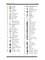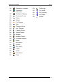
1
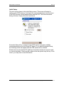
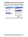
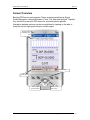
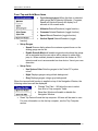
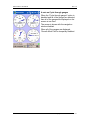
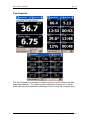
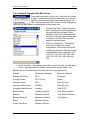
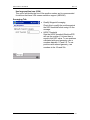
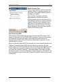
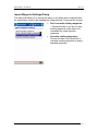
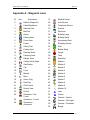
Pocket PC Cache Navigation & Management Made Simple!™
May 25, 2007
User Manual
Copyright © 2004-2007 VisualGPS, LLC
BeeLineGPS™ User Manual
Rev 1.78
Table of Contents
TABLE OF CONTENTS
2
INTRODUCTION
Requirements
6
6
INSTALLATION
Installation From a PC
7
7
RUNNING BEELINEGPS FOR THE FIRST TIME
Warning and License
Registration
Initial Setup
9
9
10
11
SCREEN OVERVIEW
13
System Menu
14
Tools (menu item)
Configuration
GPS
Track
View
Enter License Key
Help
About BeeLineGPS
Exit Application
14
14
15
15
16
16
16
16
16
Waypoint (menu item)
Goto Waypoint
Cancel Goto
Mark Waypoint at Current Position
New Waypoint
Waypoint Average
Edit Waypoints
Delete Waypoints
Show waypoint on map
Waypoint Management
File Operations
16
16
16
16
17
17
17
17
17
17
17
GPS (Tab)
19
Panel
19
BeeLineGPS™
2
Copyright © 2004-2006 VisualGPS, LLC
BeeLineGPS™ User Manual
Rev 1.78
Panel
20
Compass
Panel Tap-and-Hold Menu Items
23
24
Trip Computer
Trip Computer Tap-and-Hold Menu Items
26
27
Map
Keys
Map Tap-and-Hold Menu Items (map screen)
Map Tap and Hold Menu Items (Navigation Window)
28
28
29
30
Analysis
Active Keys
Analysis Tap-and-Hold Menu Items
Set This Plot Type
Clear This Plot
Properties
Screen Configuration
Clear All Plots
31
31
31
31
32
32
32
32
Waypoint Management
Edit Waypoint
Delete Waypoint
Range Selection
Sorting
Column Width
Goto/Show
List Nearest/List All
33
34
34
34
35
35
35
35
Waypoint Edit Dialog
Settings
Active Waypoint
Geocache State
Notes
Field Notes
36
36
37
38
39
40
Edit Multiple Waypoints Dialog
Icon/State
Active Waypoint
41
41
42
Map Properties Dialog
Map Tab
Averaging Tab
43
43
44
Import Waypoint Settings Dialog
46
BeeLineGPS™
3
Copyright © 2004-2006 VisualGPS, LLC
BeeLineGPS™ User Manual
Rev 1.78
APPENDIX A – WAYPOINT ICONS
BeeLineGPS™
47
4
Copyright © 2004-2006 VisualGPS, LLC
BeeLineGPS™ User Manual
Rev 1.78
WARNING AND PRECAUTIONS
Always be aware of your actions and surroundings while operating BeeLineGPS.
Do not operate BeeLineGPS while driving a vehicle. BeeLineGPS is not
designed as a primary navigational aid. Failure to pay full attention while
operating the vehicle and road conditions while operating the vehicle could result
in an accident or collision with property damage and personal injury.
BeeLineGPS and its animated character are property of VisualGPS,LLC
BeeLineGPS™
5
Copyright © 2004-2006 VisualGPS, LLC
BeeLineGPS™ User Manual
Rev 1.78
Introduction
BeeLineGPS is a Pocket PC application that will assist in waypoint and cache
navigation. Some of its features include waypoint management, active waypoints,
and advanced navigation features with over 100 icons to represent marked
positions.
Active waypoints allow individual waypoints to trigger a sound file and show an
active message when the current position is within a specified distance. This
technology can be used for voice guided tours as well as notifications of safety or
red light cameras. The active message includes a compass showing direction,
distance, and name of the active waypoint
The advanced waypoint database management can manage thousands of
waypoints while maintaining high performance navigating. With this technology in
place geocaching features are included to manage the life cycle of a geocache.
There are 10 icons to assist in the status of the geocache such as, identifying,
found, logged, to do, attempted, as well as many other cache states.
Requirements
•
Pocket PC 2002, Windows Mobile 2003 or Windows Mobile 2005
•
GPS Receiver with NMEA output
•
5MB or more free RAM
NMEA Sentences required:
NMEA ID
Description
GGA
Global Positioning System Fix Data - reports time, position and fix
related data
GSA
GNSS DOP and Active Satellites - reports which satellites are
being used for navigation and DOP (dilution of precision) values
GSV
GNSS Satellites in View - reports the signal to noise ratios for
each satellite tracked as well as the azimuth and elevation of each
satellite
RMC
Recommended Minimum Specific GNSS Data - Reports position,
speed over ground, and date
BeeLineGPS™
6
Copyright © 2004-2006 VisualGPS, LLC
BeeLineGPS™ User Manual
Rev 1.78
Installation
There are two methods of installing BeeLineGPS. The first is using the install
program on a PC (BeeLineGPSInstall.exe) and the second using the .CAP file
directly from the Pocket PC (BeeLineGPSInstall.HPCPro_ARM.CAB) while
supporting Windows Mobile 2003 and Pocket PC 2002 platforms.
It is recommended to download the latest version of BeeLineGPS from
www.VisaulGPS.net.
Installation From a PC
Make sure that you have the Pocket PC connected to the desktop computer and
that you ActiveSync active and run “BeeLineGPSInstall.exe.” Follow the
instructions.
Click
BeeLineGPS™
7
Copyright © 2004-2006 VisualGPS, LLC
BeeLineGPS™ User Manual
Rev 1.78
1. Accept
2. Next
At this step ActiveSync will start and install BeeLineGPS. After the installation is
complete you may run BeeLineGPS from the programs
BeeLineGPS™
8
Copyright © 2004-2006 VisualGPS, LLC
BeeLineGPS™ User Manual
Rev 1.78
Running BeeLineGPS For The First Time
Warning and License
You can start BeeLineGPS from the programs menu of your Pocket PC. When
BeeLineGPS is run for the first time, it will show several screens. The first is the
warning screen. If you agree to the terms of the warning, select Agree.
The next screen is the License Page. This page only appears when the product
has not been purchased or registered. It shows the number of days left in the
evaluation period. BeeLineGPS is fully functional during and after the evaluation
period. However the evaluation license is only valid for 30 days from the first time
BeeLineGPS is run. You may purchase BeeLineGPS and acquire a license key
by visiting the BeeLineGPS website at www.VisualGPS.net/BeeLineGPS and
selecting Register/Purchase.
If you have the registration license key, you can select the Enter Key button and
enter the registration key now. If you choose to enter the registration key, be sure
to enter this number exactly as it appears. It is a case sensitive.
If you choose not to enter the registration key, you can do so at a later time by
selecting the menu item Tools->Enter License Key.
BeeLineGPS™
9
Copyright © 2004-2006 VisualGPS, LLC
BeeLineGPS™ User Manual
Rev 1.78
Registration
When entering the Registration Key, make sure that it is typed in exactly as it
appears preserving the case of the text. Typically, there are numbers and alpha
characters mixed in with the registration key.
After the key is entered, select the OK button at the top of the screen.
BeeLineGPS will then verify the key and immediately notify you if it was a
successful key entry.
BeeLineGPS™
10
Copyright © 2004-2006 VisualGPS, LLC
BeeLineGPS™ User Manual
Rev 1.78
Initial Setup
The next screen shown is the Initial Setup screen. This screen will assist in
setting up the GPS receiver. If you know the communications port and the baud
of the GPS receiver, select Manual Setup and then OK. The communications
dialog will show. Simply follow the instructions.
Automatic Setup will try to search for the GPS receiver using the available
communications ports on the Pocket PC device. If you select Automatic Setup,
the following screen will appear and the GPS search will be initiated.
Please note on some Pocket PC platforms, the built-in serial ports may be used
for various hardware. There may be a chance that the system may lock up. If this
occurs, you may have to reset the device.
BeeLineGPS™
11
Copyright © 2004-2006 VisualGPS, LLC
BeeLineGPS™ User Manual
Rev 1.78
Below shows the automatic GPS search window. It may take a few minutes to
locate the GPS receiver. The search will open each serial communications port
at various baud rates and listen for the GPS NMEA data. After receiving NMEA
data, the automatic GPS setup will verify the output by listing for specific NMEA
data.
BeeLineGPS™
12
Copyright © 2004-2006 VisualGPS, LLC
BeeLineGPS™ User Manual
Rev 1.78
Screen Overview
BeeLineGPS has six main screens. These screens are defined as Signal
Quality/Navigation, Azimuth/Elevation, Panel, Trip, Map and Analysis. Together
they provide the user with GPS status for quick and precise glances.
Navigation between screens can be accomplished by tapping on the tabs or
using the left and right joystick keys to switch pages.
Change screens
by tapping on the
tabs
Joystick Keys
System Menu
Press to go to
previous screen
BeeLineGPS™
Press to go to
next screen
13
Copyright © 2004-2006 VisualGPS, LLC
BeeLineGPS™ User Manual
Rev 1.78
System Menu
The “System Menu” bar is present in all of BeeLineGPS’s tabbed windows. There
are two top level menu items, Tools and Waypoint. The Tools menu item has
configuration sub-menus for the GPS, waypoint settings and other BeeLineGPS
system related items. The Waypoint menu has waypoint related items. Below are
descriptions of each menu item.
Tools (menu item)
The Tools menu is one of the system main menus. It is the
central place for configuration and system settings for
BeeLineGPS.
Configuration
The configuration menu item will show several
configuration items.
•
Map Properties – Select this menu item to show the Map Properties
dialog. See the Map Properties Dialog section for a detailed explanation.
•
Import Waypoint Settings – Select this menu item to change the waypoint
import behavior. See Import Waypoint Settings section for more
information.
•
Units – Select this menu item to setup the program measurement units.
This includes distance, speed, altitude and position formats
(Latitude/Longitude).
•
Miscellaneous Settings – Select this menu item for miscellaneous settings.
Currently settings include automatic power suspend modes.
BeeLineGPS™
14
Copyright © 2004-2006 VisualGPS, LLC
BeeLineGPS™ User Manual
Rev 1.78
GPS
The GPS menu item holds all the different GPS
settings and utilities.
•
Setup Serial Port (Comm Port) – Invokes the serial port communication
settings dialog.
•
Playback Logged NMEA File – Select this menu item to play back a
previously logged file.
•
Record NMEA Log
o Start – Starts a log session
o Stop – Stops current log session
•
Manufacture Specific
o Setup SiRF NMEA Output – Select this menu item to send setup
strings to the GPS receiver. If you know that the GPS is a SiRF
based GPS engine and it is not sending all of the correct NMEA
strings, then select this menu item.
•
Autodetect GPS – Select this menu item to search for a GPS receiver.
Track
The Track Menus help manage some of the track items
such as export, erase and where to store the track file.
•
Export Track – Choose this menu item if you like to export a track file.
o Export to CSV file… - (Comma separated value)The format is
“Latitude, Longitude, Altitude, New Track Segment”.
o Export to KML file… - This export option will export the track to a
Google Earth track file format
o Export to GPX file… - This export option will export the track to a
GPX track file
•
Track File
o New – Creates a new track file at the specified location.
BeeLineGPS™
15
Copyright © 2004-2006 VisualGPS, LLC
BeeLineGPS™ User Manual
Rev 1.78
o Open – Opens an existing track file. When a new track file is
opened, this file will become the default location where the track is
maintained.
•
Erase Current Track – Clears and erases the current track on the map.
View
The view menu will allow you to hide or show specific items.
•
Status Bar – Shows or hides the status bar
•
Window Tabs – Shows of hides the window tabs. When the window tabs
are hidden, you can use the left and right joystick keys to navigate to the
next or previous page.
Enter License Key
Select this menu item to show the License Key dialog. This is where you will
enter the license key to license BeeLineGPS. To purchase a license, please visit
www.VisualGPS.net/BeeLineGPS.
Help
This menu item will invoke the BeeLineGPS help file.
About BeeLineGPS
This menu item will show the version and copyright information dialog.
Exit Application
Select this menu item to close and exit BeeLineGPS.
Waypoint (menu item)
The Waypoint system menu will allow you to manage, select and create
waypoints.
Goto Waypoint
This menu item will show a dialog of waypoints.
Choose a waypoint to “Go To” and tap on the
OK button.
Cancel Goto
Select this menu item to cancel the active “Go
To”
Mark Waypoint at Current Position
BeeLineGPS™
16
Copyright © 2004-2006 VisualGPS, LLC
BeeLineGPS™ User Manual
Rev 1.78
This menu item will create a new waypoint at the current position as reported by
the GPS receiver. The Waypoint Edit dialog will be shown to allow modification of
waypoint parameters.
New Waypoint
Select this waypoint to create a new waypoint. The Edit Waypoint dialog will be
shown so you can enter the position and modify other parameters.
Waypoint Average
Waypoint averaging will allow you to create a waypoint at a static
location by averaging. Averaging will better your accuracy for the
waypoint created.
•
Start – Starts a new position average.
•
Stop/Done – Stop averaging and create a new waypoint using the new
average position.
•
Cancel – Stops averaging and does not create a new waypoint.
Edit Waypoints
This menu item will show a dialog of waypoints. Choose a waypoint and tap on
OK to edit that specific waypoint.
Delete Waypoints
This menu item will show a dialog of waypoints. You can choose a waypoint and
select OK to delete that waypoint. To cancel, simply tap on the “Cancel” button.
Show waypoint on map
This menu item will show a dialog of waypoints. Choose waypoint and tap on OK
to display that specific waypoint on the map. The waypoint will be centered on
the map screen.
Waypoint Management
Select this menu item to active the Waypoint Management dialog. See the
Waypoint Management section for more information.
File Operations
•
Export Waypoints – Exports waypoints
•
Import Waypoints – Imports waypoints
•
Waypoint Database
BeeLineGPS™
17
Copyright © 2004-2006 VisualGPS, LLC
BeeLineGPS™ User Manual
Rev 1.78
o Open – Opens an existing waypoint database file. This file will
become the default waypoint database.
o New – Creates a new waypoint database file. This file will become
the default waypoint database.
BeeLineGPS™
18
Copyright © 2004-2006 VisualGPS, LLC
BeeLineGPS™ User Manual
Rev 1.78
GPS (Tab)
The GPS tab shows GPS signal quality, position, DOP values and satellite
azimuth/elevation. Tapping on the screen will switch from the Position status to
DOP status. Tapping on the screen once again will switch from DOP/Satellite
status to satellite azimuth/elevation. Tapping once again on the screen will switch
back to position status.
Satellite PRN
Values
Signal Quality
Signal Quality
Page 2 of 3
Satellite PRN
Values
Page 1 of 3
Position
Status
DOP
Status
Satellite
Status
Signal Quality
Satellite PRN
Values
Page 3 of 3
DOP
Status
BeeLineGPS™
19
Copyright © 2004-2006 VisualGPS, LLC
BeeLineGPS™ User Manual
Rev 1.78
Panel
The panel screen shows the analog representation of speed, direction, altitude
and vertical speed. The analog gauges may be displayed one at a time or all four
depending on the configuration. By default, a digital navigation window is also
shown below the analog gauges. This window may be enabled or disabled.
The alternate menu allows you to select the gauge to be displayed. When Cycle
Through Gauges is selected, each gauge is displayed for five seconds. Below
shows the Altimeter and Vertical Speed selected.
Setup Gauges will allow settings for specific gauges such as maximum speed for
the speedometer.
BeeLineGPS™
20
Copyright © 2004-2006 VisualGPS, LLC
BeeLineGPS™ User Manual
Rev 1.78
Gauges
Altimeter
An altimeter is an active instrument used to
measure the altitude above a fixed level. The
traditional altimeter found in most aircraft
works by measuring the air pressure from a
static port. Air pressure decreases with an
increase of altitude.
BeeLineGPS takes the altitude from the
GPGGA NMEA message provided by the
GPS.
NOTE: The unit measure (feet or meter) can
be selected for the system by selecting menu
item Tools->Configuration->Units.
Vertical Speed (Variometer)
Variometers measure the rate of change of
altitude by detecting the change in air
pressure (static pressure) as altitude
changes. Since BeeLineGPS cannot detect
air pressure, it will calculate the vertical
speed by using the change of altitude vs.
time.
BeeLineGPS™
21
Copyright © 2004-2006 VisualGPS, LLC
BeeLineGPS™ User Manual
Rev 1.78
Speedometer
The speedometer shows the current speed
the GPS has reported. The speed is taken
from the GPRMC NMEA command.
BeeLineGPS™
22
Copyright © 2004-2006 VisualGPS, LLC
BeeLineGPS™ User Manual
Rev 1.78
Compass
The compass is a navigational instrument for finding directions on earth. The
BeeLineGPS compass will show the direction of travel, distance to the current
waypoint “go to” and the direction to the waypoint.
The blue arrow will show the direction of the waypoint in respect to your direction
of travel. The direction of travel is shown at the top of the compass. The compass
below is showing a direction of travel of 89° and the waypoint, Cabin, is to the left
4.2 miles.
The Navigation Window may be enabled or disabled. To disable the Navigation
Window, tap and hold over the navigation window and select menu item “Show
Nav Window”. To enable the Navigation Window, tap and hold anywhere on the
Panel Window and select menu item “Show Nav Window”. This is a toggle
function and when the Navigation window is enabled, a check mark will be next
to the menu item.
BeeLineGPS™
23
Copyright © 2004-2006 VisualGPS, LLC
BeeLineGPS™ User Manual
Rev 1.78
Panel Tap-and-Hold Menu Items
•
Cycle through gages When this item is selected,
each gauge that is selected (Altimeter, Compass,
Speed and Vertical Speed) will display for 5
seconds in full screen mode.
•
Altimeter Selects/Deselects (toggle function)
•
Compass Selects/Deselects (toggle function)
•
Speed Selects/Deselects (toggle function)
•
Vertical Speed Selects/Deselects (toggle
function)
•
Setup Gauges
o Speed Shows a dialog where the maximum speed shown on the
analog gauge can be set.
o Enable Smooth Mode will enable a special mode where the gauge
will be animated and the new value will be slewed to rather then
jump to. When enabled, please be aware that this feature is CPU
intensive and is not recommended on slow device. Use at your own
discretion.
•
Setup Color
o Use System Color Sets the gauges to the Pocket PC system
colors.
o Night Displays gauges using a black background.
o Gray Displays gauges using a gray background.
When the tap-and-hold function is applied on top of the Navigation Window, the
following menu items will be displayed.
•
•
Change This Field… Will allow the user to select
from a list of “trip-computer” fields.
•
Show Nav Window will enable or disable the
Navigation Window.
Reset Trip Data will reset the trip computer. All items will be reset to zero.
For more information on the the trip computer, see the Trip Computer
section.
BeeLineGPS™
24
Copyright © 2004-2006 VisualGPS, LLC
BeeLineGPS™ User Manual
Rev 1.78
A note on Cycle through gauges
When the “Cycle through gauges” option is
disabled and all of the gauges are selected,
then all of the gauges are displayed on the
screen at one time.
The screen is shown with the navigation
window disabled.
When all of the gauges are displayed,
“Smooth Mode” will be temporally disabled.
BeeLineGPS™
25
Copyright © 2004-2006 VisualGPS, LLC
BeeLineGPS™ User Manual
Rev 1.78
Trip Computer
The Trip Computer is a versatile tool able to monitor over 30 different trip data
items simultaneously. The screen can be configured to display one to twenty
fields each can be programmed individually to one of many trip computer items.
BeeLineGPS™
26
Copyright © 2004-2006 VisualGPS, LLC
BeeLineGPS™ User Manual
Rev 1.78
Trip Computer Tap-and-Hold Menu Items
A tap-and-hold action on top of the Trip screen will invoke
a menu. The tap-and-hold menu will allow you to set the
specific field where the tap-and-hold was activated. You
can configure each field, the number of fields displayed or
reset the trip data. Below is a description of each menu item.
•
•
Change This Filed – Select this menu
item to change the field data where the
tap-and-hold was activated. When
selected it will show a dialog allowing
the user to choose a specific data type
to display in the field. See the table
below for trip data items.
•
Screen Configuration – Choose this
menu item to setup the screen
configuration. The screen is setup as
column/row where the following screen
configurations may be selected: 1X1,
1X2, 1X3, 1X4, 2X2, 2X3, 2X4, 2X5,
2X6, 3X4, 3X5, 3X6, 4X3, 4X4 and
4X5.
Reset Trip Data – Choose this menu item to reset all of the trip data items
to zero. Any items such as distance and duration will be reset to zero.
Below is a list of trip data items that each field can be programmed to.
Altitude
Distance to Waypoint
Minimum Gradient
Altitude Difference
ETA
Odometer
Average Grade
ETA 12 Hour
Speed
Aberage Speed
ETE
Time (12 hour)
Average Grade Ascent
Gradient
Time (24 hour)
Average Grade Descent
Heading
Time (UTC)
Battery Status
Heading Symbolic
Total Altitude Ascent
Bearing
Maximum Altitude
Total Altitude Descent
Bearing Symbolic
Maximum Gradient
Trip Duration
Blank
Maximum Speed
Cross Track Error
Minimum Altitude
BeeLineGPS™
27
Copyright © 2004-2006 VisualGPS, LLC
BeeLineGPS™ User Manual
Rev 1.78
Map
The map screen will display waypoints, tracks, and the current position as
received from the GPS receiver. It will also allow waypoints to be selected and
manipulated using a variety of functions.
By using the “tap-and-hold” feature of the Windows Mobile device, many
functions may be accessed to manipulate waypoints and map features.
Current
Position
Signal
Quality
Waypoints
Navigation
Window
Track
Keys
The map screen uses the joystick keys to zoom in and out. Use the Joystick up
key to zoom in and the joystick key to zoom in. Use the left and right joystick
keys to switch screens.
Zoom In
Previous
Screen
Next Screen
Joystick
Keys
Zoom Out
BeeLineGPS™
28
Copyright © 2004-2006 VisualGPS, LLC
BeeLineGPS™ User Manual
Rev 1.78
Map Tap-and-Hold Menu Items (map screen)
These menu items are shown when the tap-andhold was invoked on top of the map window.
Goto This Waypoint
When a tap-and-hold is activated on a waypoint,
this menu item will be enabled. If selected, then
the selected waypoint will be enabled as the “go
to” destination.
Edit This Waypoint
When a tap-and-hold is activated on a specific
icon, this menu item will be enabled. Selecting
this menu item will show the Waypoint Edit dialog. For more information please
see the Waypoint Edit Dialog section.
Delete This Waypoint
When a tap-and-hold is activated on a specific icon, this menu item will be
enabled. Selecting this menu item will immediately delete the selected waypoint.
Geocaching
The Geocaching menu section holds sub-menus related to Geocache specific
items. When a tap-and-hold is activated on a specific waypoint and the waypoint
is a Geocache, the following menu items will be enabled.
•
Found it - This is a shortcut for forcing the selected a cache waypoint
as found. You will also be prompt for field notes if you choose.
•
No Found - Select this menu item to force a cache to the Not Found
state.
•
Show Geocache Info - Select this menu item to show the Geocache
details. The details will be shown using the web browser.
Mark Waypoint Here
This menu item will mark a new waypoint at the point where the tap-and-hold
was invoked. It will then show the Edit Waypoint Dialog so that the details of the
waypoint may be entered.
Center Map Here
Centers the map to where the tap-and-hold was invoked.
BeeLineGPS™
29
Copyright © 2004-2006 VisualGPS, LLC
BeeLineGPS™ User Manual
Rev 1.78
Center Map to Current Position
Select this menu item to center the map to the current position as reported by the
GPS receiver. This item is the same as selecting the “Exit Pan” button on the
map.
Set Current Position Here
Select this menu item to set the current position to the point where the tap-andhold was invoked. This is useful if there is no GPS receiver connected.
Erase Current Track
Erases and clears the current track.
Map Settings
This menu section holds some quick settings for the map as well as the “Map
Properties” menu item.
•
North Up - Select this menu item to enable the North up map mode.
•
Course Up - Select this menu item to enable the Course up map
mode.
•
Map Properties - Shows the Map Properties dialog.
Map Tap and Hold Menu Items (Navigation Window)
These menu items are shown when the tap-and-hold was invoked on top of the
Navigation Window.
•
Change This Field - Select this menu item to change the individual fields
to output a different navigation item.
•
Hide Window - Hides the Navigation Window. You can enable this
window in the Map Properties dialog.
•
Map Properties - Shows the Map Properties dialog.
BeeLineGPS™
30
Copyright © 2004-2006 VisualGPS, LLC
BeeLineGPS™ User Manual
Rev 1.78
Analysis
The Analysis window can plot up to four
different plots simultaneously with a choice of
several plot types. This screen is useful for
looking at data trends such as altitude profile.
Currently the plot types supported are:
•
Acceleration
•
Altitude
•
Speed
•
Track Error
•
Vertical Speed
We are always receptive to additional data
fields from users. Please send us your
suggestions.
Active Keys
The up and down joystick keys will act as a plot zoom in and zoom out.
Analysis Tap-and-Hold Menu Items
A tap-and-hold action on top of the analysis plots will
invoke a menu. Some plot types may have additional
settings and if they do, then the Properties menu item will
be enabled. Please note that to set specific settings for a
particular plot, tap-and-hold on top of the corresponding
plot. For example, if the Altitude plot is active and a tapand-hold has been activated on top of the Altitude plot, then the Properties menu
item will be enabled.
Set This Plot Type
•
Acceleration – This plot will show acceleration in witch the plot will show
the change in velocity over time.
•
Altitude – Shows the altitude change over distance. If a tap-and-hold is
activated on top of the altitude graph, then the Properties menu item is
enabled and addition parameters may be set for this plot.
•
Speed – Show the speed over time.
•
Track Error – Shows the track error distance over time
•
Vertical Speed – Shows vertical speed over time.
BeeLineGPS™
31
Copyright © 2004-2006 VisualGPS, LLC
BeeLineGPS™ User Manual
Rev 1.78
Clear This Plot
Select this menu item to erase the plot where the tap-and-hold was activated.
Properties
This menu item may or may not be enabled depending of the plot where the tapand-hold was activated. If there are further settings for the specific plot, then this
menu item will be enabled.
Screen Configuration
Select this menu item to selects different screen configuration modes of 1X1,
1X2, 1X3 and 2X2.
Clear All Plots
Select this menu item to clear and erase all of the plot data for all plot types.
BeeLineGPS™
32
Copyright © 2004-2006 VisualGPS, LLC
BeeLineGPS™ User Manual
Rev 1.78
Waypoint Management
The Waypoint Management Dialog helps in managing waypoints. This includes
editing, deleting, sorting and searching. Actions on multiple waypoints may be
applied such as deleting and editing.
The waypoint manager is divided into two sections, the waypoint list and the
toolbox.
You can expand the toolbox by using toolbox expansion button located in the
upper right corner ( ). This button will also allow you to close the toolbox so the
waypoint list can display more information.
Toolbox
Waypoint
List
Some of the toolbox management functions can be accessed by a tap-and-hold
on a specific waypoint or a range of waypoints. The toolbox will also allow you to
apply a search filter when displaying the waypoint list. Note that the search filter
is preceded by the “List” rule. I.E. if the list rule is set to “Nearest” and the Max
Dist is set to 10 miles, then the search filter is applied to all waypoints within a 10
mile radius. To apply the search rule on all waypoints, the “List” rule must be set
to “All”.
To apply the Search Filter, check the “Enable Filter” checkbox. The “Enable
Filter” checkbox will automatically check if text is typed in the “Search Text” edit
box. After entering the search text, tap on the “Refresh” button to display the
results. Use the “Match Case” checkbox to match the exact case of the search
text. Below is an example of a search for “Anaheim”.
BeeLineGPS™
33
Copyright © 2004-2006 VisualGPS, LLC
BeeLineGPS™ User Manual
Rev 1.78
Edit Waypoint
To edit a waypoint, select that waypoint and tap on the edit button. This will show
the Waypoint Edit Dialog.
To edit multiple waypoints, select the first waypoint, enable the keyboard, select
the Ctl key and select the individual waypoints to edit.
When editing multiple waypoints, only specific items may be changed. These
items are Icon, Geocache State, and Active Waypoint parameters. The changes
will be applied to all of the waypoints that were selected.
Please note that multiple edits and single edits invoke different waypoint edit
dialogs. See Edit Multiple Waypoints Dialog for a detailed description.
Delete Waypoint
To delete a waypoint, select the waypoint and tap the delete button. As with
waypoint edit, you may delete multiple waypoints. To delete multiple waypoints,
select the first waypoint, enable the keyboard, select the Ctl key and select the
individual waypoints to delete.
Range Selection
To select a range of waypoints, select the first waypoint, enable the keyboard,
select the shift key and then select the last waypoint.
BeeLineGPS™
34
Copyright © 2004-2006 VisualGPS, LLC
BeeLineGPS™ User Manual
Rev 1.78
Sorting
Sorting may be applied to individual columns. To sort by an individual column,
select (tap) the column header and the list will sort using that column as the sort
key. A small triangle will appear next to the column to indicate the current sort
column.
Column Width
Clicking in the column dividers, the width of each column may be adjusted. The
width will be retained the next time the software is run.
Goto/Show
The Goto and Show (show waypoint on map) buttons will immediately close the
Waypoint Management Dialog and perform the function. Only one waypoint may
be selected to use the Goto and Show buttons.
List Nearest/List All
This drop down list will control how the waypoints are listed. When List Nearest is
select, then only waypoints within the Max Dist (Maximum Distance) threshold
are listed. This is the distance from the current position. If List All is selected,
then all of the waypoints in the database are listed and the Max Dist is ignored.
Whenever the List or Max Dist is changed, you must tap the Refresh button to
apply the change and refresh the waypoint list.
Please note that large number of waypoints listed may take a few seconds to
display.
BeeLineGPS™
35
Copyright © 2004-2006 VisualGPS, LLC
BeeLineGPS™ User Manual
Rev 1.78
Waypoint Edit Dialog
The Waypoint Edit Dialog allows items within the waypoint record to be changed.
The dialog is separated into specific page tabs to allow data entry easily. Each
page tab is described below.
Settings
The Settings tab shows the basic items associated with the waypoint such as
position, name, and icon.
BeeLineGPS™
36
Copyright © 2004-2006 VisualGPS, LLC
BeeLineGPS™ User Manual
Rev 1.78
Active Waypoint
Active Waypoint configures the waypoint to act as a proximity waypoint where a
sound file may be played along with an active message box. This is useful for
warning messages and self guided tours.
To enable the waypoint to act as an active waypoint, check Active. The trigger
distance is the distance radius that the waypoint will trigger if within that distance.
Select the “. . .” button to access a sound file or type in the directory path and file
name.
BeeLineGPS™
37
Copyright © 2004-2006 VisualGPS, LLC
BeeLineGPS™ User Manual
Rev 1.78
Geocache State
Geocaching is fast becoming a popular GPS activity. For more information on
Geocaching, please visit, www.geocaching.com. BeeLineGPS has added
features to support Geocaching in several ways. The Geocache tab helps with
manage the waypoint as a Geocache.
To enable the Geocache feature, check the Set icon to Geocache State. This will
set the icon shown for the waypoint to one of ten Geocaching icons depending
on the Geocache State. Some of the states may show different icons depending
on the state and the time that the cache was hidden. When the cache state is set
to Not Found, it will display one of three icons depending on the time the cache
was placed. If the cache was placed within 30 days of the time on the PDA, the
waypoint will show the New Cache ( ) icon. If the cache was placed before the
current date on the PDA, the waypoint will displayed as a Future Cache ( ). If
the cache is older than 30 day, then the Not Found ( ) icon will be displayed.
Archived or
missing
This icon shows that this is an archived or missing cache.
Attempted
Shows that an attempt was made to find this cache, but has not yet
been found.
Bonus
This state is handy to identify a bonus cache.
Earthcache
Indicates that a unique geological features exist here.
First to Find
Shows that this cache was a First to Find! (FTF)
Found
This icon represents a found cache, but not yet recorded on the
Geocache web site.
BeeLineGPS™
38
Copyright © 2004-2006 VisualGPS, LLC
BeeLineGPS™ User Manual
Rev 1.78
Found and
recorded
This icon shows that this cache has been found and recorded on to
the Geocache web site.
Future Cache
This is a future cache -- The date on the cache shows a date this is
in the future from the current date on the Pocket PC.
Letterbox Cache
Shows that this cache is a letterbox cache where only clues give you
the location of the cache.
Milestone
Shows that this cache was a personal milestone.
Multi Cache
Shows that this cache is part of a multi-cache.
My Cache
This icon that this is a cache that you have hidden.
Mystery Cache
Mystery or puzzle cache
New Cache
If the cache has been placed within 30 days of the current date, then
the "Not Found" icon will show as a new cache icon.
Not Found
This is the standard icon for caches that have not yet been found.
To Do
This icon shows that you plan to find this cache and is still on your to
do list.
Unknown Cache
Same as Mystery Cache
Virtual Cache
Indicates a cache made of a location. Point of Interest.
Notes
The Notes tab simply allows notes or a description for the waypoint. When using
the active waypoint feature, the notes are displayed in the message dialog in
certain modes.
BeeLineGPS™
39
Copyright © 2004-2006 VisualGPS, LLC
BeeLineGPS™ User Manual
Rev 1.78
Field Notes
Field notes are for general purpose notes about the waypoint. Feel free to write
anything here.
BeeLineGPS™
40
Copyright © 2004-2006 VisualGPS, LLC
BeeLineGPS™ User Manual
Rev 1.78
Edit Multiple Waypoints Dialog
BeeLineGPS has the capability to edit multiple waypoints. When editing multiple
waypoints, a special waypoint edit dialog will show. This dialog will only allow
specific items to be changed. Each item or items that can be changed has a
modify check box above it. To apply the change to the item, check the modify
check box.
NOTE: To edit multiple waypoints, see the Range Selection in the Waypoint
Management dialog section of this manual.
Icon/State
The Icon/State tab allows you to change the Geocache State or the icon for the
waypoint. Please note that if the Set icon to Geocache State is set, the icon
shown will be automatic depending on the Geocache state.
BeeLineGPS™
41
Copyright © 2004-2006 VisualGPS, LLC
BeeLineGPS™ User Manual
Rev 1.78
Active Waypoint
The Active Waypoint tab allows modification to the Active Waypoint parameters.
Check the Modify Active Waypoint check box and setup the individual
parameters to modify these parameters.
BeeLineGPS™
42
Copyright © 2004-2006 VisualGPS, LLC
BeeLineGPS™ User Manual
Rev 1.78
Map Properties Dialog
Use this dialog to change the map orientation and enable/disable specific map
details.
Map Tab
North Up
North Up will orient the map such that North is always up.
Course Up
Course Up will orient the map such that the direction of travel is at the top of
the map.
Waypoint Arrival Alarm Distance
Use this parameter to adjust when the waypoint arrival is triggered. This
applies only to a GoTo waypoint.
View Navigation Window
Enables the Navigation Window on the map. The Navigation Window can
show navigation status such as speed, direction and distance to a GoTo
waypoint.
View Altitude Profile Window
The Altitude Profile Window will show the altitude graphically as time
progresses.
Use large waypoints on map (VGA)
This option will double the size of the waypoint icon on the map screen and is
recommended for devices that have VGA screen resolution support
(480X640).
BeeLineGPS™
43
Copyright © 2004-2006 VisualGPS, LLC
BeeLineGPS™ User Manual
Rev 1.78
Use large position icon (VGA)
This option will double the size of the position marker and is recommended
for devices that have VGA screen resolution support (480X640).
Averaging Tab
BeeLineGPS™
•
Qualify Waypoint Averaging
Check this to qualify the position against
the DOP threshold before using it in the
average.
•
HDOP Threshold
Sets the HDOP threshold. BeeLineGPS
will use the position if it is less than or
equal to this DOP value. To use positions
calculated with good geometry, use a
numbers between 1.0 and 5.0. To use
positions with relaxed geometry, use
numbers in the 10s and 20s.
44
Copyright © 2004-2006 VisualGPS, LLC
BeeLineGPS™ User Manual
Rev 1.78
Enable Position Filter
Under normal operation, this item should be
checked. When in a stationary position, the
GPS position will wander and the position is
changing very slightly.
When the filter is enabled, it will take
approximately a “Distance Threshold”
position change before a new track point is
recorded and certain trip computer items are
updated. When the filter is disabled, every
new position is recorded in the track log as
well as used in the trip computer. The map
screen will always show the current position
that the GPS receiver sends.
Use Course from GPS
When checked, BeeLineGPS will use the course from the GPS receiver. The
course is extracted from the GPRMC NMEA command. When not moving some
GPS receivers will report an erratic course where the course will show a
bouncing around affect. Some GPS receivers have filters to prevent a course
change when not moving.
When not checked, BeeLineGPS will calculate the course internally based on the
“Distance Threshold”. BeeLineGPS will take the previous position, the new
position (after the GPS has moved more than the threshold) and calculate a new
course. When not moving, the course will not change unless the GPS moves
more than the “Distance Threshold”. The disadvantage of this method is when
the user is trying to move short distances to locate a waypoint or Geocache. The
user would have to move at lease the “Distance Threshold” before a new course
is calculated.
BeeLineGPS™
45
Copyright © 2004-2006 VisualGPS, LLC
BeeLineGPS™ User Manual
Rev 1.78
Import Waypoint Settings Dialog
This dialog will allow you to choose the action to be taken when a waypoint with
the same name exists in the database as being imported. There are two choices.
BeeLineGPS™
•
Don’t overwrite existing waypoints
– Choose this item if you do not want
existing waypoints in the data to be
overwritten by newly imported
waypoints.
•
Overwrite existing waypointe –
Choose this item if you would like to
overwrite existing waypoints by newly
imported waypoints.
46
Copyright © 2004-2006 VisualGPS, LLC
BeeLineGPS™ User Manual
Rev 1.78
Appendix A – Waypoint icons
ID
Icon
Description
27
Medical Center
0
Default (Waypoint)
28
Auto Service
1
Home/Residence
29
Telephone Service
2
National Park
30
Summit
3
Bar/Pub
31
Restroom
4
Airport
32
Building Large
5
Parking Area
33
Building Small
6
Picnic Area
34
Amusement Park
7
Forest
35
Shopping Center
8
Hiking Trail
36
Park
9
Fishing Area
37
Barber Shop
10
Drinking Water
38
Target
11
Camping Area
39
Tank
12
Danger Area
40
Explosion
13
4 wheel Drive Road
41
Marker 1
14
Gas Station
42
Marker 2
15
Car
43
Marker 3
16
Food
44
Marker 4
17
Marina
45
Marker 5
18
Mine
46
Marker 6
19
Green Flag
47
Marker 7
20
Red Flag
48
Marker 8
21
Golf Course
49
Marker 9
22
Scenic View
50
Marker 10
23
Do Not
51
Lake
24
Geocache – Not
Found
52
Ocean
53
Camera – Speed
54
Camera – Red Light
55
Camera – Roadside
56
Bridge
25
Geocache – Found
26
Geocache –
Attempted
BeeLineGPS™
47
Copyright © 2004-2006 VisualGPS, LLC
BeeLineGPS™ User Manual
Rev 1.78
86
Geocache – New and
Not Found
87
Geocache –
Future/Event Cache
88
Geocache – My
Cache
Trailer Parking
89
Helipad
63
Post Office
90
64
Ranger Station
Building –
Government
65
Skiing Area
91
Light Pole
66
Dot
92
Bank
67
Earthquake Fault
93
Rocks
68
Water Stream/Creek
94
Geocache – Multi
69
Tsunami and Flood
Damage
95
Radiator Water
96
Point of Interest
70
Military
97
Direction Left
71
Ghost Town
98
Direction Right
72
Bird Watching
99
Direction Straight
73
Boat Ramp
100
Benchmark
74
Telephone Pole
101
Rock Climbing
75
Cell Site
102
Lighthouse
76
Radio Repeater
103
Zoo
77
Data Collection
Station
104
Border Crossing
105
78
HAM Radio Shack
Geocache – First to
Find
79
Parachute Area
106
Trash
80
Wireless Hotspot
107
Train Station
81
Rest Stop
108
Bus Stop/Station
82
Weather Station
109
Cemetery
83
Geocache-Found and
Logged
110
Stadium
111
Information
84
Geocache – ToDo
112
Geocache – Milestone
85
Geocache – Archived
113
Geocache – Unknown
114
Geocache – Mystery
57
Road Block
58
Museum
59
Antenna
60
Hotel/Motel
61
Club
62
BeeLineGPS™
48
Copyright © 2004-2006 VisualGPS, LLC
BeeLineGPS™ User Manual
Rev 1.78
115
Geocache – Letterbox
138
Traffic Light
116
Geocache –
Earthcache
139
City (small)
140
City (medium)
117
Geocache – Mystery
141
City (large)
118
Fire lookout Tower
142
Stables
119
Police
120
School
121
Fire Damage
122
Start
123
Geocache Bonus
124
Arial Tramway
125
Christian Church
126
Jewish Temple
127
Mosque
128
Buddhist Temple
129
Projected Waypoint
130
Beach
131
Microphone
132
Speaker
133
Ship Wreck
134
Castel
135
Tower
136
Roundabout
137
Ruins
BeeLineGPS™
49
Copyright © 2004-2006 VisualGPS, LLC
BeeLineGPS™ User Manual
Rev 1.78
BeeLineGPS End User License
VisualGPS, LLC.
You should carefully read the following terms and conditions before using this software. Unless you have a different
license agreement signed by VisualGPS, LLC. your use, distribution, or installation of this copy of BeeLineGPS indicates
your acceptance of this License.
If you do not agree to any of the terms of this License, then do not install, distribute or use this copy of BeeLineGPS. If
you paid VisualGPS, LLC. for this copy individually, you may return it unused, within thirty (30) days after purchase, for a
full refund of your payment.
This copy of BeeLineGPS may either be used by a single person who uses the software personally on one or more
computers, or installed on a single workstation used non-simultaneously by multiple people, but not both. This is not a
concurrent use license.
You may access this copy through a network, provided that you have obtained an individual BeeLineGPS license for each
workstation that will access BeeLineGPS through the network. For instance, if 8 different workstations will access
BeeLineGPS on the network, each workstation must have its own BeeLineGPS license, regardless of whether they use
BeeLineGPS at different times or concurrently.
This software, and all accompanying files, data and materials, is distributed "AS IS" and with no warranties of any kind,
whether express or implied. Good data processing procedure dictates that any program be thoroughly tested with noncritical data before relying on it. The user must assume the entire risk of using the program. This disclaimer of warranty
constitutes an essential part of the agreement.
Any liability of VisualGPS, LLC. will be limited exclusively to refund of purchase price. In addition, in no event shall
VisualGPS, LLC., or its principals, shareholders, officers, employees, affiliates, contractors, subsidiaries, or parent
organizations, be liable for any incidental, consequential, or punitive damages whatsoever relating to the use of
BeeLineGPS, or your relationship with VisualGPS, LLC..
In addition, in no event does VisualGPS, LLC. authorize you to use BeeLineGPS in applications or systems where
BeeLineGPS's failure to perform can reasonably be expected to result in a significant physical injury, or in loss of life. Any
such use by you is entirely at your own risk, and you agree to hold VisualGPS, LLC. harmless from any claims or losses
relating to such unauthorized use.
This Agreement is the complete statement of the Agreement between the parties on the subject matter, and merges and
supersedes all other or prior understandings, purchase orders, agreements and arrangements. The laws of the State of
California shall govern this Agreement. Exclusive jurisdiction and venue for all matters relating to this Agreement shall be
in courts and located in the State of California, and you consent to such jurisdiction and venue.
All rights of any kind in BeeLineGPS which are not expressly granted in this License are entirely and exclusively reserved
to and by VisualGPS, LLC.. You may not rent, lease, modify, translate, reverse engineer, decompile, disassemble or
create derivative works based on BeeLineGPS. There are no third party beneficiaries of any promises, obligations or
representations made by VisualGPS, LLC. herein.
DISCLAIMER
In no event shall VisualGPS, LLC. be liable for any loss of profit or any other commercial or private damage, including but
not limited to special, incidental, consequential or other damages, resulting from or in any way connected with the use of
this software. VisualGPS, LLC. specifically disclaims any other warranties expressed or implied, including but not limited
to the implied warranties of merchantability and fitness for a particular use.
WARNING
Do not operate BeeLineGPS while driving a vehicle. BeeLineGPS is not designed as a primary navigational aid. Failure to
pay full attention while operating the vehicle and road conditions while operating the vehicle could result in an accident or
collision with property damage and personal injury.
BeeLineGPS™
50
Copyright © 2004-2006 VisualGPS, LLC