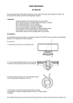
1
ArcPad Tools for ArcView GIS 3.x IN THIS CHAPTER • Installing the ArcPad Tools extension 16 ArcPad Tools is an extension to ArcView GIS 3.2 or 3.3 that provides tools for preparing your data for use with ArcPad. The extension includes tools to: Export ArcView GIS 3.x theme legend symbology to ArcPad layer files. • The ArcPad Tools Create subsets of large datasets and, if necessary, convert the data to shapefiles. • Preparing your data for ArcPad Create a screenshot of the view. • Exporting symbology Provide a summary of the data and symbology fonts used by the active view. • Creating a screenshot of the view Create an ArcPad map. • Creating an ArcPad map Pack shapefiles. • Using the Summary tool Change the codepage for the current ArcView GIS project. • Packing shapefiles • Changing the project codepage The ArcPad Tools for ArcView GIS 3.x extension does not include all of the tools that may be needed for data preparation. Projecting your data can be done using the ArcView GIS 3.x Projection Utility, while custom data input forms can be created using ArcPad Studio, which is included with the ArcPad Application Builder. The ArcPad Tools for ArcView GIS 3.x extension is a sample extension for data preparation. The ArcView GIS project and Avenue source scripts for the extension are included with ArcPad for you to customize and incorporate them into your own ArcView GIS data preparation application or extension. 279