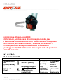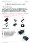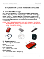
1
English
Beyond Navigation
…………………………………………………………………………………………………………………………………
…………………………………………………….
BT-Q1000eX Quick Installation Guide
A. Standard Package
GPS Unit BT-Q1000eX (1) + Lithium-ION Rechargeable
Battery (2) + Cigarette Adapter (3) + mini USB Cable (4) +
Driver CD (5) + Leather Bag (6) + Warranty Card + User’s
manual + Optional Travel Charger (* Travel Charger plug
type might be adjusted according to corresponding
countries.)
NOTE: The Cigarette Adaptor can only be used to charge
BT-Q1000eX. Please don’t make use of it with devices
other than BT-Q1000eX.
1.
2.
3.
4.
5.
6.
B. Appearance
1. Power jack (mini USB
type)
2. Mode switch
(OFF/1Hz/5Hz)
3. Battery status LED
(Red/Green)
4. Bluetooth status LED (Blue)
…………………………………………………………………………………………………………………………………
…………………………………………………….
www.Qstarz .com
1
English
…………………………………………………………………………………………………………………………………
…………………………………………………….
5.
GPS status LED (Orange) /
Log Status LED (Red)
6. Internal antenna
7. POI button
C. Hardware Function
Hardware
Function
Mode
Switch
(OFF)
Mode
Switch
(1Hz)
Mode
Switch
(5Hz)
Description
Power off BT-Q1000eX
When switch to 1Hz
mode, BT-Q1000eX
can be used to
navigate with
handheld devices,
and the data log
function is enabled at
1Hz speed. Other log
conditions setting
(Time/Distance/Speed
) can apply.
When switch to 5Hz
mode, BT-Q1000eX
can be used to
navigate with
handheld devices,
and the data log
function is enabled at
Bluetoot
h Status
Log
status
Off
Off
On
On
On
On
................................................................................................................................................................................
.........
2
www.Qstarz.com
English
Beyond Navigation
…………………………………………………………………………………………………………………………………
…………………………………………………….
Power
Jack
POI Button
5Hz dedicated mode.
Other log conditions
setting can not apply.
Take the power cable and connect it to the
power jack (mini USB type) for charging
only
Push to log the favorite Point of Interest
Note: 5Hz mode will consume more power than 1Hz mode
(42hrs). The approximate usage time of 5Hz mode is 32
hours.
Mode Switch (OFF)
(
5
Mode Switch (1Hz)
Mode Switch
H
z
)
D. Battery Installation
D-1 Put Battery in place: Press the PUSH button on the
bottom side of the unit and pull out the battery cover.
Insert battery in the unit and put battery cover on to the
cabinet, then push down and force it forward to fit firmly.
D-2 Take Battery out: Press the PUSH button on the
bottom side of the unit and pull out the battery cover.
Then take out the battery from the unit.
…………………………………………………………………………………………………………………………………
…………………………………………………….
www.Qstarz .com
3
English
…………………………………………………………………………………………………………………………………
…………………………………………………….
E. Charging your battery
For the first time using the BT-Q1000eX, please charge
battery until it is fully charged. Take the power cable and
connect it to the power jack (mini USB type) and recharge
through USB cable, travel charger or car cigarette adaptor.
This will begin to charge the battery. Charging time is 3
hours typically.
- When the Power LED flashes,
battery power is low status.
Please recharge.
- When the Power LED is Green,
the battery is under charging
mode.
- When the Power LED is off, the
battery is fully charged.
F. Setup BT-Q1000eX
F-1 Install the USB Driver and software utility (Only
support Microsoft Windows XP / Vista / 7)
Please insert the Software CD to your computer. The
autorun window will appear and please select Q1000eX.
Please press “Install PC Suite” to install the main program.
If the autorun windows did not appear, please browse the
CD and find the folder “Utility\PC Suite\”. Double click
“Qstarz_PC_Suite_installer_M.exe” to install the software
utility package. This software package contains USB driver,
QTravel™, and QSports™ software inside.
F-2 Install Google Earth
BT-Q1000eX supports to show your travel path directly on
................................................................................................................................................................................
.........
4
www.Qstarz.com
Beyond Navigation
English
…………………………………………………………………………………………………………………………………
…………………………………………………….
Google Earth. Please go to http://earth.google.com for
getting the free download of Google Earth, and then
install it to your computer.
G. Start to use
G-1 Fully charge the battery when using at the first time
A fully charged battery can last up to 42 hours
continuously operation (under 1Hz mode).
G-2 Connect BT-Q1000eX with your PC
Please connect BT-Q1000eX with your PC by mini USB
cable, and then power on BT-Q1000eX.
G-3 Start the software utility
NOTE 1: Before starting the software utility, please make
sure that the driver and the software utility has been
installed properly.
NOTE 2: PC Suite only supports BT-Q1000eX. Any intention
to use PC Suite connecting GPS units other than
BT-Q1000eX would result in software disconnection
automatically.
QSports™:
QSports™ is software with database structure
QSports™ can record, manage, and analyze all your
daily/weekly/monthly activities with various sports gear
such as Cycling, Running, Jogging, Climbing, Skiing, etc.
Train yourself by means of QSports™ statistics to have
good health control. Different sport gear will generate
corresponding category for better management and
analysis.
1. Click from <Start> / <All Programs> / <Qstarz PC Suite> /
QSports
…………………………………………………………………………………………………………………………………
…………………………………………………….
www.Qstarz .com
5
English
…………………………………………………………………………………………………………………………………
…………………………………………………….
Users have to input product key at the first time of use. The
product key is located on the cover of the software
CD.
Important: Do not lose your Product Key. Please
write the number down and keep it in a safe place.
2. Add New User
QSports™ supports multiple users. User information
includes “User Name”, Gender, Birth Date, and Weight. In
order to get correct calories calculation, please fill in the
correct personal data.
3. <File> \ < Import Wizard >
Import Wizard can guide you to load the tracks from GPS
device easily.
3.1 Select default “Sport Type”. QSports will create
tracks with the default sport type, and users can
change the sport type after import.
3.2 QSports™ will automatically detect the COM port
and baud rate and load in the GPS tracks.
3.3 Activate the Lap analysis function: once import
the data from Q1000eX, the lap analysis function
will be activated. The Lap Analysis View button
will appear on toolbar.
NOTE: Make sure to Power on GPS unit first before
connecting with computer for downloading tracks.
4. <File> \ <Export Wizard>
Export Wizard can guide you to proceed export process
easily.
4.1 HTML: Pack selected tracks and photos into
editable html files or a single easy sharing mht
................................................................................................................................................................................
.........
6
www.Qstarz.com
Beyond Navigation
English
…………………………………………………………………………………………………………………………………
…………………………………………………….
4.2
file.
Google Earth: KML and KMZ are Google Earth files
formats.
KML file contains detail waypoints and tracks info.
KMZ file contains both simple track and photos
info.
4.3 Track File: Export tracks and placemarks as GPX,
NMEA, and CSV file formats.
5. <Lap Analysis>
Lap analysis allows you to compare the data of each lap
by time, by distance, or by user defined start/finish point.
5.1 Add Start/Finish point: click the black white flag
on the right side of Google Map, and then put the
black white flag on the start/finish point of the
lap/line.
For Circuit: please put one start/finish point or one
start point and one finish point.
For Line: need to put one start point and one finish
point.
5.2 Add split points: click the red flag on the right side
of Google Map, and then put the red flag on the
place of the lap/line that you want to know more
detail about it.
5.3 <Update Lap Info Now!>
Show the lap analysis info instantly by distance,
time, or user defined start/finish point.
<By Distance>
Data will be split and shown by each distance
value. Only for one way not repeating the circuit
or line.
<By Time>
…………………………………………………………………………………………………………………………………
…………………………………………………….
www.Qstarz .com
7
English
…………………………………………………………………………………………………………………………………
…………………………………………………….
Data will be split and shown by each time value.
Only for one way not repeating the circuit or line.
<By user defined start/finish point>
Data will be split and shown by user defined
start/finish and split points. Only for repeating the
circuit or line.
5.4 <Comparison>
Select tracks to compare to the current track. The
comparison is meaningful when the paths are
similar.
NOTE: To easily compare data among many devices,
please change the device unique ID from software ->
Config GPS -> User Name. Then the imported track will be
given a specific file name based on that user name.
*For detail QSports functionality, please refer to QSports
Users Manual attaching with Software.
QTravel™:
QTravel™ is the best Geotagging software to integrating
your travel track and photo together easily. Support track
editing, playback, and import/export Wizard.
1. Click from <Start> / <All Programs> / <Qstarz PC Suite> /
QTravel
Users have to input product key at the first time of use. The
product key is located on the cover of the software
CD.
Important: Do not lose your Product Key. Please
write the number down and keep it in a safe place.
2. <File> \ < Import Wizard >
Import Wizard can guide you to proceed the Geotag
................................................................................................................................................................................
.........
8
www.Qstarz.com
Beyond Navigation
English
…………………………………………………………………………………………………………………………………
…………………………………………………….
process easily.
2.1 The Import Wizard will jump out every time during
program startup. You can also launch it by
clicking <File> \ <Import Wizard> or the quick link
icon.
2.2 Select the method to import the tracks from
device.
<Import tracks and photos into new trip>
Create a new trip to save the tracks
<Select trip to import tracks and photos>
Save the tracks into an existed trip
<Import whole trip from project file (*.itm)>
Import a trip from a project file saved by Travel
Recorder software
2.3 QTravel™ will automatically detect the com port
and baud rate and load in the GPS tracks.
2.4 A track list window will be popped up. Select the
tracks to import.
2.5 Please select the photo folder to import photos for
geotag. You can also skip this step by clicking
<Finish> directly and then there will be only tracks
shown on Google Map.
NOTE: Make sure to Power on GPS unit first before
connecting with computer for downloading tracks.
3. <File> \ <Export Wizard>
Export Wizard can guide you to proceed export process
easily.
3.1 HTML: Pack selected tracks and photos into
editable html files or a single easy sharing mht
file.
3.2 Google Earth: KML and KMZ are Google Earth files
…………………………………………………………………………………………………………………………………
…………………………………………………….
www.Qstarz .com
9
English
…………………………………………………………………………………………………………………………………
…………………………………………………….
formats.
KML file contains detail waypoints and tracks info.
KMZ file contains both simple track and photos
info.
3.3 Track File: Export tracks and placemarks as GPX,
NMEA, and CSV file formats.
3.4 Project File: Export whole trip as a Travel Recorder
software compatible project file.
4. <File> \ <Download AGPS Data>
Update the AGPS data from internet assistance server to
boost warm start speed to 15sec.
A-GPS is a system where outside sources, such as an
assistance server and reference network, help a GPS
receiver boosts performance beyond that of the same
receiver in a stand-alone mode by downloading the
almanac data from an assistance server.
Note1: A-GPS can boost GPS warm start speed to always
lower than 15sec fix after the first fix. The A-GPS
efficiency will decrease when time goes by. If it
expires, you would have to download almanac data
again because the acceleration efficiency of fix will
become totally ineffective.
Note2: Please don’t update the almanac data via
Bluetooth interface.
*For detail QTravel™ functionality, please refer to
QTravel™ Users Manual attaching with Software.
Register your Product Key:
You can register your product key in “QSports™ or
QTravel™ -> about -> Input Product Key” by an email
................................................................................................................................................................................
.........
10
www.Qstarz.com
Beyond Navigation
English
…………………………………………………………………………………………………………………………………
…………………………………………………….
account. This email with a registered product key will be
saved in Qstarz database. You can check your product
key by presenting the corresponding email to Qstarz at
any time.
Update the Software:
Please always go to Qstarz download page to check if
there is any latest software update.
http://www.qstarz.com/download.htm
Please uninstall the old version before installation.
Note: The license of Qstarz PC Suite is different from that of
stand-alone installation package of QTravel™. Thus you
are unable to update QTravel software only. Please make
sure to download the PC Suite installation package for
update.
H. Navigate as a Bluetooth GPS Receiver with
handheld device
H-1 Activate the Bluetooth function in your PDA/Smart
phone or PC
Before activating the Bluetooth function in your PDA/PC,
please switch BT-Q1000eX to <1Hz> or <5Hz> position for
paring and check if your device is equipped with
Bluetooth function. If not, you may need to acquire an
optional CF/SD Bluetooth card or Bluetooth dongle. (The
pass code is “0000”)
H-2 Automatically create a shortcut in Bluetooth
Manager window
After the pairing complete, the system will then find a
…………………………………………………………………………………………………………………………………
…………………………………………………….
www.Qstarz .com
11
English
…………………………………………………………………………………………………………………………………
…………………………………………………….
quick connect device “Qstarz 1000EX” in Bluetooth
Manager. In further use, you just need to click it to
connect to this Bluetooth GPS Receiver.
H-3 Check the Serial Port in Bluetooth Setting
After complete pairing with BT-Q1000eX, please click
“Serial Port” to confirm the assigned COM port. If you use
PDA/PC to pair the GPS Receiver, please check
“Outbound COM port”.
H-4 Set correct Serial Port in your map software
Activate your navigation software and make sure to
select the correct “Serial Port”.
NOTE 1: In the map software such as TomTom, you might
need to change preference and set “Other
Bluetooth GPS” according to PDA/phone model. In
some case please consult map software company
to vary the setting if you have issue on positioning.
NOTE 2: There might be specific setting requirement per
navigation software. Such as Tomtom, please
delete other GPS settings under Tomtom software,
and keep one only.
H-5 Switch off the Bluetooth function
Switch off GPS function in your PDA/Smart phone/PC, then
the Bluetooth connection will be disconnected
automatically. Then put BT-Q1000eX switch to “OFF”
position.
................................................................................................................................................................................
.........
12
www.Qstarz.com
Beyond Navigation
English
…………………………………………………………………………………………………………………………………
…………………………………………………….
I. Function of Vibration Sensor
Vibration Sensor: Vibration Sensor is functioned for power
saving and waypoint saving. It will detect the physical
movement of the device. When it detects the device not
moving more than 10 minutes, Q1000eX will enter sleep
mode so that the Blue LED will turn to flash every 5
seconds. Under sleep mode the log will be disabled.
When the device is on sleep mode, SHAKE the device to
wake it up and the blue LED will turn to flash every 2
seconds (at 5Hz mode this blue LED will not flash) and GPS
Orange LED will be also on.
*Vibration Sensor function is turned on as default and can
be turned off by provided software -> config GPS.
Note: Once the device enter sleep mode and it may auto
wake-up when detecting “significant” movement. We
strongly suggest you to use SHAKE method as first priority
to wake-up device in case some tracks might not be
recorded.
J. Mount BT-Q1000eX on your eXtreme Sports
Equipment
1. Clean Surface
Use isopropyl rubbing alcohol or white spirits, wipe lightly,
let dry. Do not use household cleaner.
Caution: Do not use with delicate or any rough
surface.
2. Remove male Velcro strip and adhesive liner
…………………………………………………………………………………………………………………………………
…………………………………………………….
www.Qstarz .com
13
English
…………………………………………………………………………………………………………………………………
…………………………………………………….
3. Press Firmly
Position Velcro strip and press entire Velcro strip firmly for
30 sec.
4. Wait 1 hour before use.
5. Slide Q1000eX into leather bag
Slide Q1000eX smoothly into leather bag. Attach the
leather bag to male Velcro and press entire leather bag
firmly.
Caution: If the device will be exposed to outside
environment, such as attached on motorcycle,
any other safety protection equipment must be
applied to prevent the device from sliding out of
the bag.
To get best accuracy, please position the GPS antenna
side up to sky.
................................................................................................................................................................................
.........
14
www.Qstarz.com
Beyond Navigation
English
…………………………………………………………………………………………………………………………………
…………………………………………………….
Added safety protection equipment demonstrates:
Limitation of liability:
Qstarz will not be liable for any loss or damage arising
from this accessory, whether direct, indirect, special,
incidental or consequential. It’s owner’s liability to protect
Q1000eX during doing any extreme activity.
…………………………………………………………………………………………………………………………………
…………………………………………………….
www.Qstarz .com
15
English
…………………………………………………………………………………………………………………………………
…………………………………………………….
K. Others
K-1 LED Indicators
Flash
LED Status
Power
Low Power (Red)
(Red/Gree
n)
Bluetooth
(Blue)
Flash per 2 sec.:
Bluetooth
connected and
transmitting Mode
Flash per 5 sec.:
Power saving mode
GPS
(Orange)
GPS position is
fixed, Navigation
Log
(Red)
Flash per 2 sec: Low
memory (20%)
Flash 3 times:
POI(Point of Interest)
is recorded
K-2 Beeper Code
Status
Beep code
Startup
1 short
beep
GPS fix
2 short
beeps
ON
OFF
Rechargin
g (Green)
Fully
charged
Not
connecte
d / Pairing
/ Log
Mode is
on (1Hz
mode)
Detecting
Satellite,
GPS
position
not fix
Memory is
full
GPS not
powere
d / Log
Mode is
on (5Hz
mode)
GPS not
powere
d
Log
Mode
is off
Description
One short beep on off->1Hz,
Off->5Hz, 1Hz->5Hz, or
5Hz->1Hz
2 short beeps when GPS fix on
1Hz or 5Hz mode
................................................................................................................................................................................
.........
16
www.Qstarz.com
Beyond Navigation
English
…………………………………………………………………………………………………………………………………
…………………………………………………….
POI
button
Memory
exhauste
d
3 short
beeps
3 short beeps when POI button
being pressed
3 long
beeps
3 long beeps when the device
is out of memory
1 long and
1 long and then 1 short beep
1 short
when the device enters sleep
beeps
mode
*Beeper can be turned off from software -> config GPS.
Sleep
mode
K-3 GPS Features
1. Baud Rate: 115,200 bps / Datum: WGS-84;
Hot/Warm/Cold Start: 1/33/35 sec. (averaged)
2. 66-channel Bluetooth GPS Receiver with super high
sensitivity at -165dBm
3. Bluetooth Version: V1.2 / SPP profile / Class 2 with 10
meters in open space
4. Low power consumption, built-in rechargeable Lithium
battery
5. Size: 72.2 (L) X 46.5 (W) X 20 (H) mm / Weight: 64.7g
(battery included)
K-4 Register your Qstarz product
Register your Qstarz product to get the latest news,
software update, event, and product information.
http://www.qstarz.com/register/Product_reg/page.asp
…………………………………………………………………………………………………………………………………
…………………………………………………….
www.Qstarz .com
17
English
…………………………………………………………………………………………………………………………………
…………………………………………………….
L. Trouble Shooting
Question
Answer
Can
BT-Q1000eX be
used to
navigate when
travel log is on?
Yes, BT-Q1000eX is able to
navigate and log simultaneously
whether on 1Hz mode or on 5Hz
mode.
Where can I
find a travel
charger for the
GPS unit?
DC Input range of BT-Q1000eX is
4.5~5.5V. You can use a travel
charger which support DC output
range from 4.5~5.5V. You can also use
a common mini USB cable to charge
your unit via the laptop. Besides, the
battery used for BT-Q1000eX is
compatible with Nokia phones series:
BL-5C.
Can the logged
data be
downloaded
through
Bluetooth?
Yes, Q1000eX is able to transmit log
data through Bluetooth.
Why does
BT-Q1000eX
only can log
300,000~320,00
0 waypoints?
My BT-Q1000eX
could not use
42 hours (1Hz)?
We activate more options previously
to provide detailed GPS information
for user’s reference and download. So
it would use more memory. If you
reduce the options (under Log Format)
for your log, it would save the memory
and increase more waypoints.
BT-Q1000eX can use 42 hours under
the optimum environment. GPS would
need more power consumption when
................................................................................................................................................................................
.........
18
www.Qstarz.com
Beyond Navigation
English
…………………………………………………………………………………………………………………………………
…………………………………………………….
keep trying a position fix, seeking
Bluetooth connection, or under an
unstable environment (bad weather,
forest, buildings). Those would take
GPS more calculation and power
consumption. So it would spend more
power consumption. After the red LED
light is blanking, it still can be used for
your navigation without any problem.
…………………………………………………………………………………………………………………………………
…………………………………………………….
www.Qstarz .com
19
DEUTSCH
…………………………………………………………………………………………………………………………………
…………………………………………………….
BT-Q1000eX –
Schnellinstallationsanleitung
A. Lieferumfang
GPS-Gerät BT-Q1000eX (1) + Lithium-Ionen-Akku (2) +
Zigarettenanzünderadapter (3) + Mini-USB-Kabel (4) +
Treiber-CD (5) + Ledertasche (6) + Garantiekarte +
Bedienungsanleitung + Optionales Reiseladegerät (* Der
Stecker des Reiseladegerätes kann je nach Land
unterschiedlich ausgeführt sein.)
Hinweis: Der Zigarettenanzünderadapter ist speziell
ausgeführt und kann nur zum Laden des BT-Q1000eX
verwendet werden. Bitte versuchen Sie nicht, ihn mit
anderen Geräten als dem BT-Q1000eX zu verwenden.
1.
2.
3.
4.
5.
6.
B. Äußeres
1. Stromanschluss
(Mini-USB)
2. Modusschalter
(OFF/1Hz/5Hz)
................................................................................................................................................................................
.........
20
www.Qstarz.com
Beyond Navigation
DEUTSCH
…………………………………………………………………………………………………………………………………
…………………………………………………….
3. Akkustatus-LED (rot/grün)
4. Bluetooth-Status-LED (blau)
5. GPS-Status-LED (orange) /
Log-Status-LED (rot)
6. Interne Antenne
7. OVI-Taste
C. Hardwarefunktionen
Hardwarefunktio
n
Modusschalter
(OFF)
Modusschalter
(1Hz)
Beschreibung
Zum Ausschalten
des BT-Q1000eX.
Beim Umschalten
auf den 1
Hz-Modus kann
der BT-Q1000eX
zum Navigieren
mit
Handheld-Geräte
n benutzt werden,
wobei die
Funktion zur
Datenerfassung
mit der 1
Hz-Geschwindigk
eit aktiviert ist.
Andere
Einstellungen der
Protokollbedingun
gen
(Zeit/Distanz/Gesc
hwindigkeit)
können dann
Bluetooth
-Status
Protokoll
-Status
Aus
Aus
Ein
Ein
…………………………………………………………………………………………………………………………………
…………………………………………………….
www.Qstarz .com
21
DEUTSCH
…………………………………………………………………………………………………………………………………
…………………………………………………….
Modusschalter
(5Hz)
Stromanschluss
OVI-Taste
angewendet
werden.
Beim Umschalten
in den 5 Hz-Modus
kann der
BT-Q1000eX zum
Navigieren mit
Handheld-Geräte
n benutzt werden,
wobei die
Funktion zur
Ein
Ein
Datenerfassung
mit dem
dedizierten 5
Hz-Modus aktiviert
ist. Andere
Einstellungen der
Protokollbedingun
gen stehen nicht
zur Verfügung.
Mit diesem Anschluss verbinden Sie das
Stromkabel (Mini-USB) zum Aufladen.
Durch Drücken der OVI-Taste können Sie Ihre
Lieblings-OVIs (Orte von Interesse)
aufzeichnen.
Hinweis:
Im 5 Hz-Modus wird mehr Strom als im 1 Hz-Modus
aufgenommen (42 Std.). Die ungefähre
Anwendungsdauer des 5 Hz-Modus beträgt 32 Stunden.
Modusschalter (OFF) Modusschalter (1Hz)
Modusschalter (5Hz)
................................................................................................................................................................................
.........
22
www.Qstarz.com
Beyond Navigation
DEUTSCH
…………………………………………………………………………………………………………………………………
…………………………………………………….
D. Akku einlegen
D-1 Akku in das Gerät einlegen: Drücken Sie die
PUSH-Taste an der Unterseite des Geräte und nehmen Sie
den Akkufachdeckel ab. Legen Sie den Akku in das Gerät
ein, setzen Sie den Akkufachdeckel wieder auf und
drücken Sie den Deckel mit etwas Kraft hinab und etwas
nach vorne, bis er fest sitzt.
D-2 Akku entnehmen: Drücken Sie die PUSH-Taste an der
Unterseite des Geräte und nehmen Sie den
Akkufachdeckel ab. Nehmen Sie den Akku aus dem
Gerät.
E. Akku aufladen
Bevor Sie den BT-Q1000eX zum ersten Mal benutzen,
laden Sie den Akku bitte vollständig auf. Verbinden Sie
das Stromversorgungskabel mit dem Stromanschluss
(Mini-USB) des Gerätes und laden Sie das Gerät über
USB-Kabel, Reiseladegerät oder
Zigarettenanzünderadapter auf. Der Akku wird nun
geladen. Der Ladevorgang dauert gewöhnlich etwa drei
Stunden.
…………………………………………………………………………………………………………………………………
…………………………………………………….
www.Qstarz .com
23
DEUTSCH
…………………………………………………………………………………………………………………………………
…………………………………………………….
- Wenn die Betriebsanzeige-LED rot Blinken, ist der Akku
fast entladen. Bitte aufladen.
- Wenn die
Betriebsanzeige-LED grün
leuchtet, wird der Akku
gerade geladen.
- Wenn die
Betriebsanzeige-LED nicht
leuchtet, ist der Akku komplett
aufgeladen.
F. BT-Q1000eX einrichten
F-1 USB-Treiber und Software für installieren (nur unter
Microsoft Windows XP / Vista / 7 unterstützt)
Bitte legen Sie die Software-CD in Ihrem Computer ein.
Das Autorun-Fenster blendet sich ein und wählen Sie
Q1000eX. Klicken Sie auf “Install PC Suite” (PC Suite
installieren), um das Hauptprogramm zu installieren. Sollte
das Autorun-Fenster nicht erscheinen, suchen und öffnen
Sie den Ordner “Utility\PC Suite\” auf der CD.
Doppelklicken Sie auf “Qstarz_PC Suite_installer_M.exe”,
um das Software-Anwendungspaket zu installieren. Dieses
Softwarepaket enthält den USB-Treiber und die
QTravel™/QSports™-Software.
F-2 Google Earth installieren
Ihr BT-Q1000eX kann Ihre Reiseroute direkt über Google
Earth anzeigen. Bitte rufen Sie http://earth.google.com auf.
Dort können Sie Google Earth kostenlos herunterladen und
auf Ihrem Computer installieren.
................................................................................................................................................................................
.........
24
www.Qstarz.com
Beyond Navigation
DEUTSCH
…………………………………………………………………………………………………………………………………
…………………………………………………….
G. Anwendung
G-1 Akku vor der ersten Benutzung vollständig aufladen
Ein komplett geladener Akku sorgt (bei optimalen
Bedingungen) für bis zu 42 Stunden ununterbrochenen
Betrieb (Im 1 Hz-Modus).
G-2 BT-Q1000eX an den PC anschließen
Verbinden Sie den BT-Q1000eX über das Mini-USB-Kabel
mit Ihrem PC, Schalten Sie den BT-Q1000eX ein.
G-3 Software-Dienstprogramm starten
HINWEIS 1: Bevor Sie das Dienstprogramm starten, stellen
Sie bitte sicher, dass der Treiber und das
Dienstprogramm richtig installiert wurde.
HINWEIS 2: Das PC Suite unterstützt ausschließlich den
BT-Q1000eX. Jeder Versuch, das PC Suite mit
anderen GPS-Geräten als dem BT-Q1000eX zu
verbinden, führt zum sofortigen Abbruch der
Softwareverbindung.
QSports™:
QSports™ ist eine Datenbanksoftware
Mit QSports™ können Sie Ihre
täglichen/wöchentlichen/monatlichen sportlichen
Aktivitäten wie Radfahren, Laufen, Jogging, Klettern,
Skifahren, usw. aufzeichnen, verwalten und analysieren.
Wenn Sie mit den QSports™ -Statistiken trainieren, haben
Sie Ihre Gesundheit im Griff. Unterschiedliche Sportarten
…………………………………………………………………………………………………………………………………
…………………………………………………….
www.Qstarz .com
25
DEUTSCH
…………………………………………………………………………………………………………………………………
…………………………………………………….
werden in entsprechende Kategorien eingeteilt und
können so bequem verwaltet und analysiert werden.
1. Klicken Sie auf <Start> / <Alle Programme> / <Qstarz PC
Suite> / QSports
Beim ersten Starten des Programms müssen Sie die
Produktseriennummer eingeben. Die Produktserienummer
finden Sie auf der Hülle der Treiber-CD.
Wichtig: Verlieren Sie keinesfalls den Aktivierungsschlüssel.
Notieren Sie sich die Nummer und bewahren Sie diese an
einem sicheren Ort auf.
2. Neuen Benutzer hinzufügen
QSports™ unterstützt mehrere Benutzer. Zu den
Benutzerinformationen zählen Benutzername, Geschlecht,
Geburtsdatum und Gewicht. Bitte geben Sie korrekte
persönliche Daten ein, damit zum Beispiel Kalorien richtig
berechnet werden können.
3. <Datei> \ <Importassistent>
Mit dem Importassistent können Sie die Daten Ihres
GPS-Gerätes bequem laden.
3.1 Wählen Sie die Standard-„Sportart“. QSports
erstellt entsprechende Eintragungen zur
Standardsportart, die Sportart kann nach dem
Importieren geändert werden.
3.2 Das PC-Dienstprogramm erkennt COM-Port und
Baudrate zum Laden der GPS-Daten automatisch.
3.3 Die Funktion zur Überlappungsanalyse aktivieren:
Nach dem Importieren der Daten vom Q1000eX
wird die Funktion zur Überlappungsanalyse
aktiviert. Die Taste zur Ansicht der
................................................................................................................................................................................
.........
26
www.Qstarz.com
Beyond Navigation
DEUTSCH
…………………………………………………………………………………………………………………………………
…………………………………………………….
Überlappungsanalyse wird auf der Tool-Leiste
eingeblendet.
Hinweis: Achten Sie darauf, dass das GPS-Gerät
eingeschaltet ist, bevor Sie es zur
Datenübertragung mit dem Computer verbinden.
4. <Datei> \ <Exportassistent>
Vom Exportassistent können Sie sich auf einfache Weise
durch den Exportprozess leiten lassen.
4.1 HTML: Packt ausgewählte Tracks und Fotos in
editierbare HTML-Dateien oder in eine einzelne
mht-Datei zur gemeinsamen Nutzung.
4.2 Google Earth: KML und KMZ sind Dateiformate von
Google Earth.
KML-Dateien enthalten detaillierte Informationen
zu Wegpunkten und Tracks.
KMZ-Dateien enthalten einfache Track- und
Fotodaten.
4.3 Track-Datei: Exportiert Tracks und Ortsmarken in
den Dateiformaten GPX-, NMEA- und CSV.
5. <Überlappungsanalyse>
Mit der Überlappungsanalyse können die Daten einer
jeden Überlappung nach Zeit, Distanz oder nach dem
vom Benutzer vorgegebenen Start-/Endepunkt verglichen
werden.
5.1 Den Start-/Zielpunkt hinzufügen: Die
schwarze/weiße Flagge auf der rechten Seite der
Google-Landkarte anklicken und danach diese
schwarze/weiße Flagge auf den Start-/Zielpunkt
der Überlappung/Linie ziehen.
…………………………………………………………………………………………………………………………………
…………………………………………………….
www.Qstarz .com
27
DEUTSCH
…………………………………………………………………………………………………………………………………
…………………………………………………….
Für den Kreis: Einen Start-/Zielpunkt oder einen
Start- und einen Zielpunkt darauf ziehen.
Für die Linie: Einen Start- und einen Zielpunkt
darauf ziehen.
5.2 Die Teilungspunkte hinzufügen: Die rote Flagge
auf der rechten Seite der Google-Landkarte
anklicken und danach die rote Flagge auf den
Ort der Überlappung/der Linie ziehen, über die Sie
mehr Details benötigen.
KMZ-Dateien enthalten einfache Track- und
Fotodaten.
5.3 <Die Überlappungsinfos jetzt aktualisieren!>
Zum sofortigen Anzeigen der Infos über die
Überlappungsanalyse nach Distanz, Zeit oder
nach dem vom Benutzer vorgegebenen
Start-/Zielpunkt.
<Nach Zeit> Die Daten werden geteilt und nach
jedem Zeitwert angezeigt. Nur für einen Weg,
ohne den Kreis oder die Linie zu wiederholen.
<Nach dem vom Benutzer vorgegebenen
Start-/Zielpunkt>
Die Daten werden geteilt und nach dem vom
Benutzer vorgegebenen Start-/Zielpunkt und
nach den Teilungspunkten angezeigt. Nur zum
Wiederholen des Kreises oder der Linie.
5.4 <Vergleich>
Die Reisewege zum Vergleichen mit dem
gegenwärtigen Reiseweg auswählen. Der
Vergleich ist nur dann sinnvoll, wenn die Routen
................................................................................................................................................................................
.........
28
www.Qstarz.com
Beyond Navigation
DEUTSCH
…………………………………………………………………………………………………………………………………
…………………………………………………….
ähnlich verlaufen.
HINWEIS: Für einen einfachen Vergleich der Daten
zwischen zahlreichen Geräten muss die
einigartige Geräte-ID unter Software -> GPS konfig.
-> Benutzername abgeändert werden. Danach
wird dem importierten Reiseweg einen
spezifischen Dateinamen mit Basis auf diesem
Benutzernamen zugeordnet.
*Informationen zur Funktionsweise des QSports erhalten
Sie in der der Software beiliegenden
QSports-Bedienungsanleitung.
QTravel™:
QTravel™ ist eine praktische Geotagging-Software, mit
der Sie Fotos ganz einfach mit dem Aufnahmeort
verbinden können. Die Software bietet die Bearbeitung
von Tracks, Wiedergabe sowie einen
Import-/Exportassistenten.
1. Klicken Sie auf <Start> / <Alle Programme> / <Qstarz PC
Suite> / QTravel
Beim ersten Starten des Programms müssen Sie die
Produktseriennummer eingeben. Die Produktserienummer
finden Sie auf der Hülle der Treiber-CD.
Wichtig: Verlieren Sie keinesfalls den Aktivierungsschlüssel.
Notieren Sie sich die Nummer und bewahren Sie diese an
einem sicheren Ort auf.
2. <Datei> \ <Importassistent>
Vom Importassistent können Sie sich durch die
Geotag-Schritte leiten lassen.
…………………………………………………………………………………………………………………………………
…………………………………………………….
www.Qstarz .com
29
DEUTSCH
…………………………………………………………………………………………………………………………………
…………………………………………………….
2.1
Der Importassistent wird bei jedem Programmstart
automatisch eingeblendet. Sie können ihn auch
starten, indem Sie <Datei> \ <Importassistent>
wählen oder auf das Schnellverbindung-Symbol
klicken.
2.2 Wählen Sie die Methode zum Importieren der
Reisewege vom Gerät.
<Reisewege und Fotos in neue Tour importieren>
Erstellen Sie eine neue Tour, um die Reisewege zu
speichern
<Tour zum Importieren von Reisewegen und Fotos
wählen>
Speichern Sie die Reisewege in einer
vorhandenen Tour
<Gesamte Tour von Projektdatei (*.itm)
importieren>
Importieren Sie eine Tour von einer Projektdatei,
die mit der Travel Recorder-Software erstellt wurde
2.3 Das QTravel™ erkennt den genutzten COM-Port
und die Baudrate automatisch und liest
anschließend die GPS-Tracks ein.
2.4 Ein Fenster mit einer Track-Liste wird eingeblendet.
Wählen Sie die zu importierenden Tracks.
2.5 Bitte wählen Sie den entsprechenden Foto-Ordner
zum Importieren von Fotos für Geotag. Sie können
diesen Schritt auch überspringen, indem Sie direkt
auf <Fertig stellen> klicken; in diesem Fall werden
lediglich Tracks in Google Maps angezeigt.
Hinweis: Achten Sie darauf, dass das GPS-Gerät
................................................................................................................................................................................
.........
30
www.Qstarz.com
Beyond Navigation
DEUTSCH
…………………………………………………………………………………………………………………………………
…………………………………………………….
eingeschaltet ist, bevor Sie es zur
Datenübertragung mit dem Computer verbinden.
3. <Datei> \ <Exportassistent>
Vom Exportassistent können Sie sich auf einfache Weise
durch den Exportprozess leiten lassen.
3.1 HTML: Packt ausgewählte Tracks und Fotos in
editierbare HTML-Dateien oder in eine einzelne
mht-Datei zur gemeinsamen Nutzung.
3.2 Google Earth: KML und KMZ sind Dateiformate von
Google Earth.
KML-Dateien enthalten detaillierte Informationen
zu Wegpunkten und Tracks.
KMZ-Dateien enthalten einfache Track- und
Fotodaten.
3.3 Track-Datei: Exportiert Tracks und Ortsmarken in
den Dateiformaten GPX-, NMEA- und CSV.
3.4 Projektdatei: Exportieren Sie die gesamte Tour als
eine Projektdatei, die mit der Travel
Recorder-Software kompatibel ist.
4. <File> \ <Download AGPS Data>
Aktualisieren Sie die AGPS-Daten von dem
Unterstützungsserver über das Internet, um die
Warm-Start-Geschwindigkeit bis zu 15 Sek. zu erhöhen.
A-GPS ist ein System, bei dem äußere Quellen, wie z. B.
Hilfsserver und Referenznetzwerke, die Leistung des
GPS-Empfängers durch Herunterladen von
Almanachdaten vom Server im Vergleich zum
Einzel-Modus anheben.
HINWEIS 1: A-GPS kann die Warm-Start-Geschwindigkeit
…………………………………………………………………………………………………………………………………
…………………………………………………….
www.Qstarz .com
31
DEUTSCH
…………………………………………………………………………………………………………………………………
…………………………………………………….
erhöhen. Nach dem erstmaligen Bestimmen der
Position benötigt die nächste
Positionsbestimmung weniger als 15 Sekunden.
Die A-GPS-Effizienz nimmt im Laufe der Zeit ab.
Sie müssen erneut Almanac-Daten downloaden,
um die veralteten zu ersetzen. Andernfalls wird
die Positionsbestimmung sehr ineffektiv.
HINWEIS 2: Aktualisieren Sie die Almanac-Daten nicht
über die Bluetooth-Schnittstelle.
*Informationen zur Funktionsweise des QTravel™ erhalten
Sie in der der Software beiliegenden
QTravel-Bedienungsanleitung.
Registrieren Sie Ihren Produktschlüssel:
Sie können Ihren Produktschlüssel unter “ software ->
about -> Input Product Key” mit Ihrem E-Mailkonto
registrieren. Diese E-Mail Adresse wird in der Datenbank
von QStarz mit Ihrem Produktschlüssel gespeichert. Sollte
Ihnen Ihr Produktschlüssel abhandenkommen, so können
Sie diesen mit Eingabe Ihrer E-Mailadresse wieder
aufrufen.
Aktualisierung der Software:
Bitte besuchen Sie regelmäßig die QStarz-Downloadseite
und sehen sich nach den aktuellsten
Software-Aktualisierungen um.
http://www.qstarz.com/download.htm
H. Gerät als Bluetooth-GPS-Empfänger zur
Navigation mit einem Handgerät einsetzen
................................................................................................................................................................................
.........
32
www.Qstarz.com
Beyond Navigation
DEUTSCH
…………………………………………………………………………………………………………………………………
…………………………………………………….
H-1 Aktivieren Sie die Bluetooth-Funktionalität Ihres
PDAs/Smartphones oder PCs
Bevor Sie die Bluetooth-Funktionalität Ihres PDA/PC
aktivieren, bringen Sie den Schalter vom BT-Q1000eX zur
Kopplung in die Position 1Hz, 5Hz; überzeugen Sie sich,
dass Ihr PDA/PC die Bluetooth-Kommunikation beherrscht.
Falls nicht, sollten Sie eine optionale Bluetooth-Karte
(CF/SD) oder ein Bluetooth-Dongle erwerben. (Das
Kennwort lautet „0000“.)
H-2 Verknüpfung im Bluetooth Manager-Fenster
automatisch anlegen
Nach abgeschlossener Kopplung wird ein
Schnellverbindungsgerät „QSTARZ 1000EX“ im Bluetooth
Manager angelegt. Beim nächsten Einsatz können Sie zur
Verbindung mit Ihrem Bluetooth-GPS-Empfänger einfach
darauf klicken.
H-3 Seriellen Port in den Bluetooth-Einstellungen prüfen
Nachdem die Kopplung mit dem BT-Q1000eX
abgeschlossen wurde, klicken Sie zur Bestätigung des
zugewiesenen COM-Ports bitte auf „Serieller Port“. Wenn
Sie den GPS-Empfänger mit einem PDA oder PC koppeln,
markieren/überprüfen Sie bitte „Ausgehender COM-Port“.
H-4 Richtigen seriellen Port in Ihrer Kartensoftware
einstellen
Starten Sie Ihre Navigationssoftware und wählen Sie den
richtigen „seriellen Port“ aus.
HINWEIS 1: Wenn Sie eine Kartensoftware wie TomTom
benutzen, müssen Sie eventuell einige
…………………………………………………………………………………………………………………………………
…………………………………………………….
www.Qstarz .com
33
DEUTSCH
…………………………………………………………………………………………………………………………………
…………………………………………………….
Voreinstellungen ändern und je nach PDAoder Telefonmodell „Anderes
Bluetooth-GPS“ wählen. Falls es dennoch zu
Problemen bei der Positionsbestimmung
kommen sollte, wenden Sie sich bitte an den
Hersteller der Kartensoftware.
HINWEIS 2: Je nach Navigationssoftware können
bestimmte Einstellungen erforderlich sein. Bei
TomTom löschen Sie bitte sämtliche anderen
GPS-Einstellungen in der TomTom-Software
bis auf die aktuelle.
H-5 Bluetooth-Funktionalität abschalten
Schalten Sie zunächst die GPS-Funktion Ihre PDAs,
Smartphones oder PCs aus; die Bluetooth-Verbindung wird
automatisch getrennt. Bringen Sie dann den Schalter Ihres
BT-Q1000eX in die „OFF“-Position.
I. Funktion des Vibrationssensors
Vibrationssensor: Die Funktion des Vibrationssensors dient
zum Stromsparen und zum Speichern der Wegpunkte. Er
nimmt die physische Bewegung des Gerätes wahr. Wenn
festgestellt wird, dass das Gerät während länger als 10
Minuten nicht bewegt wird schaltet der Q1000eX in den
Schlafmodus, wobei die blaue LED-Leuchtdiode
aufleuchtet und alle 5 Sekunden blinkt. Im Schlafmodus
wird die Aufzeichnungsfunktion deakiviert.
Wenn das Gerät in den Schlafmodus geschaltet ist
RÜTTELN Sie am Gerät, um dieses aufzuwecken. Die blaue
LED-Leuchtdiode leuchtet auf und blinkt alle 2 Sekunden
(im 5 Hz-Modus blinkt diese blaue LED-Leuchtdiode nicht)
................................................................................................................................................................................
.........
34
www.Qstarz.com
Beyond Navigation
DEUTSCH
…………………………………………………………………………………………………………………………………
…………………………………………………….
und die orange LED-Leuchtdiode des GPS leuchtet
ebenfalls auf.
*Die Funktion des Vibrationssensors wird als Voreinstellung
aktiviert und kann mit der mitgelieferten Software -> GPS
konfig. deaktiviert werden.
Hinweis: Nach dem Umschalten des Gerätes in den
Schlafmodus kann dieses durch Feststellen einer
“deutlichen” Bewegung automatisch aufgeweckt
werden. Es wird empfohlen, das Gerät
vorzugsweise zu RÜTTELN, um dieses zu wecken für
den Fall, dass einige Spuren nicht aufgezeichnet
werden können.
J. Den BT-Q1000eX auf Ihrer
eXtreme-Sportausrüstung befestigen
1.
Die Oberfläche reinigen
Mit Isopropanol oder Terpentinersatz leicht sauberwischen
und trocknen lassen. Keine haushaltsübliche
Reinigungsmittel verwenden.
Achtung: Nicht auf zarte oder rauhe Oberflächen
aufbringen.
2.
Den Klettbandstreifen und die selbstklebende
Einlage entfernen
3.
Fest andrücken
Den Klettbandstreifen positionieren und 30 Sekunden fest
…………………………………………………………………………………………………………………………………
…………………………………………………….
www.Qstarz .com
35
DEUTSCH
…………………………………………………………………………………………………………………………………
…………………………………………………….
auf den ganzen Klettbandstreifen drücken.
4.
1 Stunde vor der Anwendung warten.
5.
Den Q1000eX in die Ledertasche gleiten
Den Q1000eX sanft und vorsichtig in die Ledertasche
gleiten. Danach die Ledertasche an das Klettband
befestigen und fest auf die ganze Ledertasche drücken.
Achtung: Falls das Gerät der Außenumgebung
ausgesetzt wird, z. B. wenn es an ein Motorrad
befestigt wird, muss das Gerät mit anderen
Sicherheitsvorrichtungen befestigt werden, um zu
verhindern, dass es herausfallen kann.
Für die beste Genauigkeit muss die GPS-Antenne nach
oben zum Himmel gerichtet werden.
Die zusätzliche Sicherheitsvorrichtung zeigt:
................................................................................................................................................................................
.........
36
www.Qstarz.com
Beyond Navigation
DEUTSCH
…………………………………………………………………………………………………………………………………
…………………………………………………….
Haftungseinschränkung:
Die Qstarz haftet für keine Verluste oder Schäden dieses
Zubehörs, weder für direkte, indirekte, Spezial-, durch
Unfall verursachte noch für Folgeschäden. Der Benutzer ist
für den Schutz des Q1000eX bei dessen Anwendung unter
Extrembedingungen alleinig verantwortlich.
K. SONSTIGES
K-1 LED-Anzeigen
LED-Stat
us
Betrieb
(rot/grün
)
Bluetoot
h (blau)
Blinken
Ein
Rot: Energiestand
niedrig
Grün:
Ladevorgang
Einmal in 2
Sekunden:
Bluetooth-Verbind
ung besteht
Einmal in 5
Sekunden:
Nicht
verbunden/Ko
ppeln /
Reiseprotokolli
erung ist an
(1Hz)
Aus
Komplett
aufgelade
n
Kein
GPS-Betrie
b/
Reiseproto
kollierung
ist an (5Hz)
…………………………………………………………………………………………………………………………………
…………………………………………………….
www.Qstarz .com
37
DEUTSCH
…………………………………………………………………………………………………………………………………
…………………………………………………….
Energiesparmodus
GPS
(orange)
GPS-Position
bestimmt,
Navigation
Satellitensuche
, GPS-Position
nicht bestimmt
Kein
GPS-Betrie
b
Log (rot)
Einmal in 2
Sekunden:
Wenig Speicher
3 x Blinken (blau):
OVI (Ort von
Interesse) wurde
aufgezeichnet
Speicher ist
voll
Reiseproto
kollierung
ist aus
K-2 Pieptonkode
Status
Piepton
Starten
Ein kurzer Piepton
GPS fixiert
Zwei kurze Pieptöne
POI-Taste
Drei kurze Pieptöne
Aufge- brauchter
Speicher
Drei lange Pieptöne
Beschreibung
Ein kurzer Piepton bei
Aus->1 Hz, Aus->5 Hz, 1
Hz->5 Hz oder 5 Hz->1 Hz
Zwei kurze Pieptöne
ertönen, wenn der GPS
fixiert ist im 1 Hz- oder 5
Hz-Modus
Beim Drücken auf die
POI-Taste ertönen drei
kurze Pieptöne
Bei aufgebrauchtem
Speicher des Gerätes
................................................................................................................................................................................
.........
38
www.Qstarz.com
Beyond Navigation
DEUTSCH
…………………………………………………………………………………………………………………………………
…………………………………………………….
ertönen drei lange
Pieptöne
Schlafmodus
Beim Umschalten des
Gerätes in den
Ein langer und ein kurzer
Schlafmodus ertönen ein
Piepton
langer Piepton, dem ein
kurzer Piepton folgt
*Der Summer kann mit Software -> GPS konfig.
ausgeschaltet werden.
K-3 GPS-Merkmale
1. Baudrate: 115.200 bps / Datum: WGS-84;
Heiß-/Warm-/Kaltstart: 1/33/35 Sek. (durchschnittlich)
2. Bluetooth-GPS-Empfänger, 66 Kanäle, extrem hohe
Empfindlichkeit: -165 dBm
3. Bluetooth-Version: V1.2 / SPP-Profil / Klasse 2, 10 Meter
bei freier Sicht
4. Geringer Stromverbrauch, integrierter Lithium-Akku (bis
42 Betriebsstunden bei voller Aufladung)
5. Abmessungen: 72,2 (L) x 46,5 (B) x 20 (H) mm / Gewicht:
64,7 g (einschließlich Akku)
K-4 Registrieren Sie Ihr QStarz-Produkt
Registrieren Sie Ihr Produkt und erhalten Sie die aktuellsten
News, Softwareupdates, Events und Produktinformationen
http://www.qstarz.com/register/Product_reg/page.asp
…………………………………………………………………………………………………………………………………
…………………………………………………….
www.Qstarz .com
39
DEUTSCH
…………………………………………………………………………………………………………………………………
…………………………………………………….
L. Problemlösung
Frage
Ich habe das
Reiseladegerät
verloren. Wo
finde ich ein
passendes
Ladegerät?
Können die
aufgezeichneten
Daten über
Bluetooth
heruntergeladen
werden?
Warum
protokolliert der
BT-Q1000eX nur
300.000 bis
320.000
Wegpunkte?
Antwort
Ihr BT-Q1000eX arbeitet mit einer
Eingangsspannung von 4,5 bis 5,5 V
Gleichspannung. Sie können passende
Reiseladegeräte verwenden, die zwischen 4,5
und 5,5 V Gleichspannung liefert. Darüber
hinaus können Sie das Gerät auch über ein
herkömmliches Mini-USB-Kabel aufladen; z. B.
über ein Notebook.
Die Daten des Q1000eX können auch über
Bluetooth heruntergeladen werden. Da diese
Verbindung jedoch weniger stabil ist und die
Datentransferrate deutlich unter der der
USB-Schnittstelle liegt, wird diese
Verbindungsmethode nicht offiziell
angegeben
Wir haben viele Optionen aktiviert, um
besonders detaillierte GPS-Daten zu
Referenzzwecken und zum Herunterladen zur
Verfügung stellen zu können. Daher wird mehr
Speicher benötigt. Wenn Sie die Optionen Ihres
Protokolls reduzieren (unter Protokollformat),
können Sie Speicher einsparen und schaffen
Platz für mehr Wegpunkte.
................................................................................................................................................................................
.........
40
www.Qstarz.com
Beyond Navigation
DEUTSCH
…………………………………………………………………………………………………………………………………
…………………………………………………….
Mein My
BT-Q1000eX
erreicht keine 42
Stunden
Betriebsdauer?
Der BT-Q1000eX kann unter optimalen
Bedingungen 42 Stunden lang eingesetzt
werden. Beim Fixieren einer Position benötigt
das GPS mehr Energie, außerdem wird beim
Suchen nach Bluetooth-Verbindungen und
beim Einsatz unter widrigen Bedingungen
(schlechtes Wetter, Wälder, Gebäude) mehr
Energie verbraucht. Solche Umstände führen
dazu, dass das GPS mehr rechnen muss und
natürlich auch mehr Energie verbraucht. Daher
steigt der Stromverbrauch. Auch wenn die rote
LED zu blinken beginnt, können Sie das Gerät
nach wie vor problemlos zur Navigation
benutzen.
…………………………………………………………………………………………………………………………………
…………………………………………………….
www.Qstarz .com
41
ESPAÑOL
…………………………………………………………………………………………………………………………………
…………………………………………………….
BT-Q1000eX - Guía de instalación rápida
A. Paquete estándar
Unidad GPS BT-Q1000eX (1) + Batería de ion-litio
recargable (2) + Adaptador para encendedor (3) + Cable
Mini-USB (4) + CD con los controladores (5) + Bolso de
Cuero (6) + Tarjeta de garantía + Manual del usuario +
Cargador portátil opcional (* El tipo de enchufe del
cargador portátil se puede ajustar en función del país.)
Nota: el adaptador para mechero tiene especificaciones
especiales y sólo se puede utilizar para cargar el modelo
BT-Q1000eX. No haga uso del mismo con otros
dispositivos que no sean del modelo BT-Q1000eX.
1.
2.
3.
4.
5.
6.
B. Diseño
1. Conector de alimentación (tipo Mini-USB)
2. Conmutador de modo: OFF (APAGADO)/1Hz/5Hz
3. LED de estado de
la batería (verde/rojo)
4. LED de estado
Bluetooth (azul)
5. LED de estado GPS
(naranja) \ LED de
................................................................................................................................................................................
.........
42
www.Qstarz.com
Beyond Navigation
ESPAÑOL
…………………………………………………………………………………………………………………………………
…………………………………………………….
estado REGISTRO (rojo)
6. Antena interna
7. Botón Punto de interés (POI)
C. Función de hardware
Función de
hardware
Conmutad
or de
modo: OFF
(APAGADO
)
Conmutad
or de
modo: 1Hz
Conmutad
or de
modo: 5Hz
Descripción
Permite apagar la unidad
BT-Q1000eX
Cuando cambia al modo
1Hz, el BT-Q1000eX se
puede utilizar para
navegar con dispositivos
manuales, y la función
de registro de datos esta
habilitada en la
velocidad de 1Hz. Puede
aplicar otra condición
de registro
(Tiempo/Distancia/Veloc
idad).
Cuando cambia al modo
5Hz, el BT-Q1000eX se
puede usar para
navegar con dispositivos
manuales, y la función
de registro de datos esta
habilitada en la
velocidad de 5Hz. No
Estado
del
Bluetooth
Estado de
Registro
APAGADO
APAGADO
ENCENDI
DO
ENCENDI
DO
ENCENDID
O
ENCENDID
O
…………………………………………………………………………………………………………………………………
…………………………………………………….
www.Qstarz .com
43
ESPAÑOL
…………………………………………………………………………………………………………………………………
…………………………………………………….
aplican otra condición
de registro.
Conector
de
alimentaci
ón
Botón
Punto de
interés
(PDI)
Conecte el cable de alimentación al conector de
alimentación (tipo Mini-USB) sólo para cargar
Pulse el botón PDI para registrar los puntos de interés
favoritos
Nota:
El modo 5Hz consumirá mas energía que el modo 1Hz
(42hrs). El tiempo de uso aproximado de 5Hz es 32 horas.
Conmutador de modo: OFF (APAGADO)
Conmutador de modo: 1Hz
Conmutador de modo: 5Hz
................................................................................................................................................................................
.........
44
www.Qstarz.com
Beyond Navigation
ESPAÑOL
…………………………………………………………………………………………………………………………………
…………………………………………………….
D. Instalación de la batería
D-1 Inserte la batería en su lugar: presione el botón
PULSAR situado en la parte inferior de la unidad y extraiga
la tapa de la batería. Inserte la batería en la unidad y
vuelva a colocar la tapa en su lugar; a continuación,
presiónela hacia abajo forzándola ligeramente hacia
delante para que quede perfectamente ajustada.
D-2 Extraiga la batería: presione el botón PULSAR situado
en la parte inferior de la unidad y extraiga la tapa de la
batería. A continuación, extraiga la batería de la unidad.
E. Cargar la batería
Cargue completamente la
batería cuando vaya a
utilizar el dispositivo
BT-Q1000eX. Enchufe el
cable de alimentación al
conector de alimentación
(tipo mini USB) y realice la
recarga a través del cargador de viaje o del adaptador
del encendedor de cigarrillos. De este modo la batería
comenzará a cargarse. El tiempo de carga es de 3
horas.
- Si el color del LED de alimentación es rojo (Parpadeo), la
carga de la batería es baja. Recárguela.
- Si el color del LED de alimentación es verde, la batería
se encuentra en el modo de carga.
- Cuando el LED de Encendido esté apagado, la batería
…………………………………………………………………………………………………………………………………
…………………………………………………….
www.Qstarz .com
45
ESPAÑOL
…………………………………………………………………………………………………………………………………
…………………………………………………….
se habrá cargado completamente.
F. Configurar la unidad BT-Q1000eX
F-1 Instalar el controlador USB y utilidad de software
(sólo compatible con Microsoft Windows XP y Vista y 7)
Inserte el CD de software en su PC. Aparecerá la ventana
de ejecución automática. Seleccione Q1000eX. Presione
“Install PC Suite” (Instalar PC Suite) para instalar el
programa principal. Si la ventana de ejecución
automática no aparece, examine el CD y busque la
carpeta “Utility\PC Suite\”. Haga doble clic en el archivo
“Qstarz_PC_Suite _installer_M.exe” para instalar el
paquete de la utilidad de software. Este paquete de
software contiene el controlador USB y el software
QTravel™/QSports™.
F-2 Instalar Google Earth
La unidad BT-Q1000eX puede mostrar la ruta del viaje
directamente en Google Earth. Visite la dirección
http://earth.google.com para obtener una descarga
gratuita de Google Earth y, a continuación, instálelo en su
PC.
G. Empezar a usar la unidad
G-1 Cargue completamente la batería cuando la use
por primera vez
Una batería completamente cargada puede
proporcionar una autonomía de hasta 42 horas de
funcionamiento continuo (en condiciones óptimas) (Bajo
el modo 1Hz).
................................................................................................................................................................................
.........
46
www.Qstarz.com
Beyond Navigation
ESPAÑOL
…………………………………………………………………………………………………………………………………
…………………………………………………….
G-2 Conecte la unidad BT-Q1000eX a su PC
Conecte la unidad BT-Q1000eX a su PC mediante el
cable Mini-USB, al encender el BT-Q1000eX.
G-3 Iniciar la utilidad de software
NOTA 1: antes de iniciar la utilidad de software, asegúrese
de que el controlador y dicha utilidad se han
instalado adecuadamente.
NOTA 2: PC Suite sólo admite BT-Q1000eX. Cualquier
intento de utilizar equipos GPS de conexión PC Suite
distintos del BT-Q1000eX provocaría la desconexión
automática del software.
QSports™:
QSports™ es una aplicación que funciona por medio de
una base de datos
QSports™ puede registrar, administrar y analizar todas sus
actividades diarias / semanales / mensuales
relacionadas con distintos deportes, como ciclismo,
carrera, jogging, escalada, esquí, etc. Entrénese
utilizando las estadísticas de QSports™ y controle su salud.
Los distintos deportes generan categorías
correspondientes para una mejor administración y
análisis.
1. Haga clic en <Start> (Inicio) / <All Programs> (Todos los
programas) / <Qstarz PC Suite> / QSports™
Los usuarios deben introducir la clave del producto la
primera vez que lo usen. La clave del producto está
situada en la portada del CD del controlador.
Importante: No pierda su Clave de Producto. Anote el
…………………………………………………………………………………………………………………………………
…………………………………………………….
www.Qstarz .com
47
ESPAÑOL
…………………………………………………………………………………………………………………………………
…………………………………………………….
número y guárdelo en un sitio seguro.
2. Agregar un usuario nuevo
QSports™ es compatible con varios usuarios. La
información del usuario incluye un “Nombre de usuario”,
género, fecha de nacimiento y peso. Con el fin de
realizar correctamente el cálculo de calorías, introduzca
los datos personales correctamente.
3. <Archivo> \ <Asistente de importación>
El Asistente de importación le guiará para cargar
fácilmente los rastros del dispositivo GPS.
3.1 Seleccione la opción predeterminada " Tipo de
deporte ". QSports creará rastros con el tipo de
deporte predeterminado. El usuario podrá
cambiar el tipo de deporte después de la
importación.
3.2 QSports™ detectará automáticamente el puerto
COM y la velocidad de baudio y leerá el rastro
GPS.
3.3 Activa la función de análisis de Circuito: una vez
importados los datos de Q1000eX, la función de
análisis de Circuito será activado. El botón de
Vista de Análisis de Circuito aparecerá en la
barra de herramientas.
Nota: asegúrese de encender el dispositivo GPS antes de
conectarlo al equipo para descargar los rastros.
4. <File> (Archivo) \ <Export Wizard> (Asistente de
Exportación)
El Asistente de Exportación puede guiarle para llevar a
cabo el proceso de exportación.
................................................................................................................................................................................
.........
48
www.Qstarz.com
Beyond Navigation
ESPAÑOL
…………………………………………………………………………………………………………………………………
…………………………………………………….
4.1
HTML: Incluye en un paquete las rutas y fotos
seleccionadas en archivos html editables o en un
solo archivo mht para compartirlas con facilidad.
4.2 Google Earth: KML y KMZ son formatos de
archivos de Google Earth.
El archivo KML contiene información detallada
sobre puntos de referencia y rutas.
El archivo KMZ contiene información sencilla de
rutas y fotos.
4.3 Archivo de Rutas: Exporta las rutas y puntos de
interés como formatos de archivo GPX, NMEA, y
CSV.
5. <Análisis de Circuito >
El análisis de Circuito le permite comparar los datos de
cada vuelta por tiempo, distancia o punto de
inicio/finalización definido por usuario.
5.1 Agregar punto de inicio/finalización:
Haga clic en la bandera negra con blanco en el
lado derecho de Google Map, luego coloque la
bandera negra con blanco en el punto de
inicio/finalización de la Circuito/línea.
Para Circuito: por favor coloque un punto de
inicio/finalización en el punto de inicio o en el
punto de finalización.
Para Línea: necesita colocar un punto de inicio y
un punto de finalización.
5.2 Agregar puntos divididos:
Haga clic en la bandera roja en el lado derecho
de Google Map, y luego coloque la bandera roja
…………………………………………………………………………………………………………………………………
…………………………………………………….
www.Qstarz .com
49
ESPAÑOL
…………………………………………………………………………………………………………………………………
…………………………………………………….
en el lugar de circuito/línea de la que quiere
saber mas detalle.
5.3 <Actualice Info del Circuito Ahora!>
Muestra el análisis de circuito instantáneamente
por distancia, tiempo o punto de
inicio/finalización definido por usuario.
<Por Distancia>
Los datos de dividirán y mostrarán por cada valor
de distancia. Solo para un recorrido, no para
repetición de circuito o línea.
<Por Tiempo>
Los datos de dividirán y mostrarán por cada valor
de tiempo. Solo para un recorrido, no para
repetición de circuito o línea.
<Por punto de inicio/finalización definido por
usuario>
Los datos de dividirán y mostrarán por punto de
inicio/finalización definido por usuario. Solo para
un recorrido, no para repetición de circuito o
línea.
5.4 <Comparación>
Seleccione rutas para comparar la ruta actual. La
comparación es significativa para rutas que son
similares.
NOTA: Para comparar fácilmente los datos entre varios
dispositivos, por favor cambie el ID único del
dispositivo desde el software -> Config GPS ->
Nombre de Usuario. Luego se le dará un nombre de
archivo especifico a la ruta importada basada en el
................................................................................................................................................................................
.........
50
www.Qstarz.com
Beyond Navigation
ESPAÑOL
…………………………………………………………………………………………………………………………………
…………………………………………………….
nombre de usuario.
*Para más detalles sobre las funciones de QSports,
consulte el Manual de Usuario de QSports incluido con el
Software.
QTravel™:
QTravel™ es el mejor programa de etiquetado
geográfico para integrar con facilidad su rastro de
desplazamiento y sus fotografías. Es compatible con la
edición de rastros, la reproducción y cuenta con un
asistente de importación / exportación.
1. Haga clic en <Start> (Inicio) / <All Programs> (Todos los
programas) / <Qstarz PC Suite> / QTravel
Los usuarios deben introducir la clave del producto la
primera vez que lo usen. La clave del producto está
situada en la portada del CD del controlador.
Importante: No pierda su Clave de Producto. Anote el
número y guárdelo en un sitio seguro.
2. <File> (Archivo) \ < Import Wizard > (Asistente de
Importación)
El Asistente de Importación puede guiarle para llevar a
cabo el proceso Geotag con facilidad.
2.1 El Asistente de Importación se abrirá cada vez
que se inicie el programa. También puede
ejecutarlo haciendo clic en <Archivo> \
<Asistente de Importación> o en el icono de
enlace rápido.
2.2 Seleccione el método para importar las rutas
desde el dispositivo.
…………………………………………………………………………………………………………………………………
…………………………………………………….
www.Qstarz .com
51
ESPAÑOL
…………………………………………………………………………………………………………………………………
…………………………………………………….
<Importar rutas y fotos en un nuevo viaje>
Cree un nuevo viaje para guardar las rutas
<Seleccionar el viaje para importar rutas y fotos>
Guarde las rutas en un viaje existente
<Importar todo el viaje desde el archivo de
proyecto (*.itm)>
Importe un viaje desde un archivo de proyecto
guardado por la aplicación Travel Recorder
2.3 La Utilidad de PC detectará automáticamente el
puerto com y la velocidad en baudios, y cargará
las rutas por GPS.
2.4 Se abrirá una ventana con una lista de rutas.
Seleccione las rutas que quiera importar.
2.5 Por favor, seleccione la carpeta de fotos para
importar fotos para geotag. También puede
saltarse este paso haciendo clic en <Finalizar>
directamente. Después sólo se mostrarán las rutas
en Google Map.
3. <File> (Archivo) \ <Export Wizard> (Asistente de
Exportación)
El Asistente de Exportación puede guiarle para llevar a
cabo el proceso de exportación.
3.1 HTML: Incluye en un paquete las rutas y fotos
seleccionadas en archivos html editables o en un
solo archivo mht para compartirlas con facilidad.
3.2 Google Earth: KML y KMZ son formatos de
archivos de Google Earth.
El archivo KML contiene información detallada
sobre puntos de referencia y rutas.
................................................................................................................................................................................
.........
52
www.Qstarz.com
Beyond Navigation
ESPAÑOL
…………………………………………………………………………………………………………………………………
…………………………………………………….
El archivo KMZ contiene información sencilla de
rutas y fotos.
3.3 Archivo de Rutas: Exporta las rutas y puntos de
interés como formatos de archivo GPX, NMEA, y
CSV.
3.4 Archivo de proyecto: exporte todo el viaje como
un archivo de proyecto compatible con la
aplicación Travel Recorder.
4. <File> \ <Download AGPS Data>
Actualizar los datos del AGPS desde el servidor de
asistencia a través de Internet para acelerar la velocidad
de inicio en caliente del servidor a 15 segundos.
El A-GPS es un sistema en el que fuentes externas, como
un servidor de asistencia o una red de referencia, ayudan
al receptor GPS aumentar su rendimiento más allá de la
capacidad del mismo receptor en modo autónomo,
descargando los datos de almanaque desde un servidor
de asistencia.
NOTA 1: El A-GPS puede acelerar la velocidad de inicio
en caliente del GPS para que sea siempre inferior
a 15 segundos tras el primer ajuste. La eficacia del
A-GPS disminuirá a medida que pase el tiempo. Si
expira, deberá descargar de nuevo los datos del
almanaque porque la eficacia de aceleración del
ajuste se volverá totalmente ineficaz.
NOTA 2: Por favor, no actualice los datos del almanaque
a través de una interfaz Bluetooth.
*Para más detalles sobre las funciones de la Utilidad de
PC del QTravel™, consulte el Manual de Usuarios
…………………………………………………………………………………………………………………………………
…………………………………………………….
www.Qstarz .com
53
ESPAÑOL
…………………………………………………………………………………………………………………………………
…………………………………………………….
del Qtravel™ incluido con el Software.
Registrar su clave de producto:
Puede registrar su clave de producto en “software ->
about -> Input Product Key” a través de una cuenta de
correo electrónico. Este mensaje de correo con su clave
de producto registrado estaría guardado en la base de
datos de Qstarz. Puede comprobar su clave de producto
en cualquier momento enviando el correo electrónico
correspondiente a Qstarz.
Actualizar el Software:
Por favor, vaya siempre a la página de descargas Qstarz
para comprobar si hay actualizaciones de
software recientes.
http://www.qstarz.com/download.htm
H. Navegar como un receptor GPS Bluetooth
con un dispositivo de bolsillo
H-1 Activar la función Bluetooth en la unidad PDA, en el
teléfono inteligente o en su PC
Antes de activar la función Bluetooth en su unidad PDA o
PC, enuentra el conmutador de modo de la unidad
BT-Q1000eX en la posición de <1Hz> <5Hz> para iniciar el
proceso de asociación y compruebe si el dispositivo
cuenta con la función Bluetooth. Si no cuenta con dicha
función, tendrá que adquirir la tarjeta Bluetooth CF/SD
opcional o la base de conexión Bluetooth. (La contraseña
es “0000”)
H-2 Crear automáticamente un acceso directo en la
................................................................................................................................................................................
.........
54
www.Qstarz.com
Beyond Navigation
ESPAÑOL
…………………………………………………………………………………………………………………………………
…………………………………………………….
ventana del administrador Bluetooth
Una vez realizada la asociación, el sistema buscará un
dispositivo de conexión rápida “QSTARZ 1000EX” en el
administrador Bluetooth. Para utilizarlo, solamente tendrá
que hacer clic en él para conectarse a este receptor GPS
Bluetooth.
H-3 Comprobar el puerto serie en la configuración
Bluetooth
Una vez completada la asociación con el receptor, haga
clic en “Puerto serie” para confirmar el puerto COM
asignado. Si utiliza la unidad PDA o su PC para asociar el
receptor GPS, active la opción “Puerto COM saliente”.
H-4 Establecer el puerto serie correcto en el software
cartográfico
Active el software de navegación y asegúrese de
seleccionar el puerto serie correcto en “Serial Port”
(Puerto serie).
NOTA 1: en el software cartográfico (como TomTom)
puede que tenga que cambiar las preferencias
y establecer la opción “Otro GPS Bluetooth”
conforme al modelo de teléfono o la unidad
PDA. En cualquier caso, consulte a la compañía
del software cartográfico para variar la
configuración si tiene problemas con el
posicionamiento.
NOTA 2: puede haber requisitos de configuración
…………………………………………………………………………………………………………………………………
…………………………………………………….
www.Qstarz .com
55
ESPAÑOL
…………………………………………………………………………………………………………………………………
…………………………………………………….
específicos según el software de navegación.
En el caso de Tomtom, elimine las
configuraciones GPS en el software Tomtom y
mantenga solamente una.
H-5 Desactivar la función Bluetooth
Desactive la función GPS de la unidad PDA, el teléfono
inteligente y su PC. Una vez hecho esto, la conexión
Bluetooth se desconectará automáticamente.
Seguidamente, coloque el conmutador de alimentación
del dispositivo BT-Q1000eX en la posición de apagado.
I. Función de Sensor de Vibración
Sensor de Vibración: El Sensor de Vibración funciona
como ahorro de energía y ahorro de punto de paso.
Detectara el movimiento físico del dispositivo. Cuando
detecta que el dispositivo no se ha movido por más de 10
minutos, el Q1000eX tiene un LED en azul parpadeara
cada 5 segundos. Bajo modo dormir se deshabilita el
registro.
Cuando el dispositivo esta en modo dormir, AGITE el
dispositivo para despertarlo y el LED azul parpadeara
cada 2 segundos. (En modo 5Hz el LED no parpadeara) y
el LED Naranja del GPS seguirá encendido.
*La función del Sensor de Vibración se encuentre como
predeterminado, y se puede apagar con el software
suministrado -> config GPS.
Nota:
Una vez el dispositivo entra en modo dormir, se puede
auto levantar al detectar movimiento “significativo”.
................................................................................................................................................................................
.........
56
www.Qstarz.com
Beyond Navigation
ESPAÑOL
…………………………………………………………………………………………………………………………………
…………………………………………………….
Sugerimos altamente que utilice el método AGITAR como
prioridad para despertar el dispositivo en caso de que
algunas rutas no sean grabadas.
J. Monte el BT-Q1000eX en su equipo
deportivo eXtreme
1.
Limpiar la Superficie
Utilice un limpión con isopropílico y alcohol o aguarrás,
pase un limpión suavemente, déjelo secar. No utilice
limpiadores domésticos.
Precaución: No utilice en superficies muy
delicadas o ásperas.
2. Remueva la tira de Velcro macho y la línea adhesiva.
3. Presione Firmemente
Ubique la tira de Velcro y presiónela firmemente por 30
segundos.
4. Espere 1 hora antes de su uso.
5. Deslice el Q1000eX dentro del bolso de cuero
Deslice el Q1000eX suavemente dentro del bolso de
cuero. Una el bolso de cuero al Velcro macho y presione
todo el bolso firmemente.
Precaución: Si expone el dispositivo al ambiente
…………………………………………………………………………………………………………………………………
…………………………………………………….
www.Qstarz .com
57
ESPAÑOL
…………………………………………………………………………………………………………………………………
…………………………………………………….
exterior, como adjuntarlo a una motocicleta,
cualquier otro equipo de protección debe
aplicarse para prevenir que el dispositivo se
deslice del bolso.
Para obtener mejor precisión, por favor coloque la antena
del GPS mirando hacia el cielo.
Demostración de equipo de protección agregado:
................................................................................................................................................................................
.........
58
www.Qstarz.com
Beyond Navigation
ESPAÑOL
…………………………………………………………………………………………………………………………………
…………………………………………………….
Limitación de Responsabilidad: Qstarz no se hará
responsable por cualquier perdida o daño en relación a
este accesorio, ya sea directa, indirecta, especial,
incidencia o consecuente. Es responsabilidad del dueño
proteger el Q1000eX mientras se realiza cualquier
actividad extrema.
K. OTROS
K-1 Indicadores LED
Estado del
LED
Alimentació
n
(rojo/verde)
Bluetooth
(azul)
Parpadeo
ENCENDIDO
APAGADO
Carga baja (rojo)
Recargando
(verde)
Carga total
2 veces por
segundo:
conexión
No
conectado/
Asociación /
GPS no
alimentado
/ El registro
…………………………………………………………………………………………………………………………………
…………………………………………………….
www.Qstarz .com
59
ESPAÑOL
…………………………………………………………………………………………………………………………………
…………………………………………………….
Bluetooth y
modo de
transmisión
5 veces por
segundo: modo
de ahorro de
energía
El registro de de viaje
viaje está
está
activado (1Hz) activado
(5Hz)
GPS
(naranja)
Posición GPS
fijada,
navegación
Detectando el
satélite,
GPS no
posición GPS alimentado
no fijada
Registro
(rojo)
2 veces por
segundo:
Memoria baja
(20%)
3 veces: el punto
de interés (PDI)
se graba
La memoria
está llena
K-2 Código de Beeper
Estado
Código de Bip
Inicio
Un bip corto
GPS fijo
Dos bips cortos
Botón POI
Tres bips cortos
El registro
de viaje
está
desactivad
o
Descripción
Un bip corto de
encendido->1Hz,
Apagado->5Hz, 1Hz->5Hz, o
5Hz->1Hz
Dos bips cortos cuando se
fija el GPS en modo 1Hz o
5Hz
Tres bips cortos cuando ha
presionado el botón POI
................................................................................................................................................................................
.........
60
www.Qstarz.com
Beyond Navigation
ESPAÑOL
…………………………………………………………………………………………………………………………………
…………………………………………………….
Tres bips largos cuando el
dispositivo esta quedando
sin memoria
Un bip largo y luego uno
Un bip largo y
corto cuando el dispositivo
Modo dormir
uno corto
entra en modo dormir.
*El Beeper se puede apagar desde el software -> config
GPS.
Memoria
llena
Tres bips largos
K-3 Funciones GPS
1. Tasa de baudios: 115.200 bps / Datos: WGS-84. Inicio en
caliente, templado y caliente: 1, 33 y 35 s (promedio)
2. Receptor GPS Bluetooth de 66 canales con sensibilidad
superalta a -165 dBm
3. Versión Bluetooth: V1.2. Perfil SPP. Clase 2 con un
alcance de 10 metros en espacio abierto
4. Bajo consumo de energía, batería de litio recargable
integrada (hasta 42 horas con carga completa)
5. Tamaño: 72,2 (LA) x 46,5 (AN) x 20 (AL) mm. Peso: 64,7
g (batería incluida)
K-4 Registrar su producto Qstarz
Registre su producto Qstarz para recibir actualizaciones
de software e información sobre el producto y eventos.
http://www.qstarz.com/register/Product_reg/page.asp
…………………………………………………………………………………………………………………………………
…………………………………………………….
www.Qstarz .com
61
ESPAÑOL
…………………………………………………………………………………………………………………………………
…………………………………………………….
L. Solucionar problemas
Pregunta
Responder
Perdí mi
cargador
portátil, ¿dónde
puedo
encontrar un
cargador
portátil para la
unidad GPS?
¿Se pueden
descargar los
datos de
registro
mediante la
tecnología
Bluetooth?
¿Por qué el
modelo
BT-Q1000eX
sólo puede
registrar
300.000~320.000
puntos de
paso?
El intervalo de entrada de CC de la unidad
BT-Q1000eX está comprendido entre 4,5 y
5,5 V. Puede usar el cargador portátil que
admite el intervalo de salida de CC
comprendido entre 4,5 y 5,5 V. Además,
también puede usar un cable Mini-USB
común para cargar la unidad a través del
equipo portátil.
En realidad, el Q1000eX puede descargar
datos a través de un interfaz Bluetooth. Sin
embargo, debido a que no es estable y
tiene menor rendimiento de descarga que
un interfaz USB, no admitimos oficialmente
esta función.
Activamos anteriormente más opciones
para ofrecer información GPS detallada
para referencia y descarga por parte del
usuario. Así, el uso de memoria era mayor.
Al reducir las opciones (en Formato de
registro) de su registro, ahorrará memoria
y aumentará el número de puntos de
paso.
................................................................................................................................................................................
.........
62
www.Qstarz.com
Beyond Navigation
ESPAÑOL
…………………………………………………………………………………………………………………………………
…………………………………………………….
¿Mi BT-Q1000eX
no puede
utilizar 42 horas
(1Hz)?
BT-Q1000eX puede utilizar 42 horas en un
entorno óptimo. El GPS necesitará más
energía para mantener fija la posición,
buscando una conexión Bluetooth, o en un
entorno inestable (mal tiempo, bosque,
edificios). Ello requeriría que su GPS
realizase más cálculos y consumiera más
energía. Después de que el LED comience
a parpadear, podrá utilizarlo para su
navegación sin problemas.
…………………………………………………………………………………………………………………………………
…………………………………………………….
www.Qstarz .com
63
FRANÇAIS
…………………………………………………………………………………………………………………………………
…………………………………………………….
Guide d’installation rapide du
BT-Q1000eX
A. Emballage standard
Unité GPS BT-Q1000eX (1) + batterie rechargeable au
lithium-ion (2) + adaptateur pour allume-cigare (3) +
câble mini USB (4) + CD des pilotes (5) + Sac en cuir (6) +
carte de garantie + manuel de l’utilisateur + chargeur de
voyage en option (* Le type de la prise du chargeur de
voyage peut être ajusté en fonction du pays
correspondant.)
Remarque: L'adaptateur d'allume cigare auto répond à
une spécification particulière et ne peut être utilisé que
pour charger le BT-Q1000eX. Veuillez ne pas l'utiliser avec
d'autres appareils que le BT-Q1000eX.
1.
2.
3.
4.
5.
6.
B. Apparence
1. Plot (type mini USB)
2. Commutateur de mode
(OFF/1Hz/5Hz)
3. DEL d’état de la batterie
(rouge/verte)
................................................................................................................................................................................
.........
64
www.Qstarz.com
Beyond Navigation
FRANÇAIS
…………………………………………………………………………………………………………………………………
…………………………………………………….
4. DEL d’état du Bluetooth (bleue)
5. DEL d’état du GPS
(orange) \
DEL d’état LOG (rouge)
6. Antenne interne
7. Bouton POI (point
d’intérêt)
C. Fonction du matériel
Fonction du
matériel
Description
Le statut
du
Bluetooth
Le status
du
journal
Commutateu
r de mode
(OFF)
Mettre le BT-Q1000eX
hors tension.
ETEINTE
ETEINTE
Commutateu
r de mode
(1Hz)
Quand vous basculez
au mode de 1Hz,
BT-Q1000eX peut être
utilisé pour naviguer
avec des dispositifs
portables (PDA /
Smartphone
/ Portable…), et la
function de
l'enregistrement des
données est activée à
la vitesse de 1Hz. Autre
condition dans la
configuration du
enregistrement peut
aussi s'appliquer
ALLUMEE
ALLUMEE
…………………………………………………………………………………………………………………………………
…………………………………………………….
www.Qstarz .com
65
FRANÇAIS
…………………………………………………………………………………………………………………………………
…………………………………………………….
Commutateu
r de mode
(5Hz)
Plot
Bouton POI
(Temps/Distance/Vitess
e).
Quand vous basculez
au mode de 5Hz,
BT-Q1000eX peut être
utilisé pour naviguer
avec des dispositifs
portables (PDA /
Smartphone
/ Portable…), et la
function de
ALLUMEE
ALLUMEE
l'enregistrement des
données est activée à
la vitesse de 5Hz.le
mode dédié. Les autre
conditions dans la
configuration du
enregistrement ne peut
pas s'appliquer.
Prendre le câble d’alimentation et le connecter au
plot (type mini USB) pour le chargement
uniquement.
Appuyer sur le bouton POI pour consigner le point
d’intérêt favori.
Note: Le mode de 5Hz va consommer plus d'énergie que
le mode de 1Hz (42hrs). La durée d'utilisation
approximative du mode 5Hz est de 32 heures.
Commutateur de mode (OFF)
mode (1Hz)
Commutateur de
................................................................................................................................................................................
.........
66
www.Qstarz.com
Beyond Navigation
FRANÇAIS
…………………………………………………………………………………………………………………………………
…………………………………………………….
Commutateur de mode (5Hz)
D. Installation de la batterie
D-1 Mettre la batterie en place : Appuyez sur le bouton
PUSH (POUSSER) situé sur le côté inférieur de l’appareil et
tirez le couvercle du compartiment à batterie. Insérez la
batterie dans l’appareil et replacez le couvercle du
compartiment à batterie sur le boîtier, puis poussez vers le
bas et forcez vers l’avant pour l’ajuster.
D-2 Retirer la batterie : Appuyez sur le bouton PUSH
(POUSSER) situé sur le côté inférieur de l’appareil et tirez le
couvercle du compartiment à batterie. Retirez ensuite la
batterie de l’appareil.
E. Chargement de votre batterie
…………………………………………………………………………………………………………………………………
…………………………………………………….
www.Qstarz .com
67
FRANÇAIS
…………………………………………………………………………………………………………………………………
…………………………………………………….
Lors de la première utilisation
du BT-Q1000eX, veuillez
charger la batterie
complètement. Prenez le
cordon d’alimentation et
branchez-le à la prise (type
mini USB), puis rechargez la
batterie au moyen du
chargeur de voyage ou de l’allume-cigare de la voiture.
Cela déclenchera le chargement de la batterie. Le temps
de chargement est généralement de 3 heures.
- Quand la DEL d’alimentation est rouge (Flash), la batterie
est faible. Veuillez la
recharger.
- Quand la DEL d’alimentation est verte, la batterie est en
mode chargement.
- Lorsque le voyant DEL d’alimentation est éteint, la
batterie est complètement chargée.
F. Configuration du BT-Q1000eX
F-1 Installer le pilote USB et un l’utilitaire logiciel (ne prend
en charge que Microsoft Windows XP/Vista/7)
Veuillez insérer le CD du logiciel dans votre ordinateur. La
fenêtre autorun apparaît ; veuillez choisir Q1000eX.
Veuillez appuyer sur "Install PC Suite" (Installer PC Suite)
pour installer le programme principal. Si les fenêtres
autorun n'apparaissaient pas, veuillez parcourir le CD et
................................................................................................................................................................................
.........
68
www.Qstarz.com
Beyond Navigation
FRANÇAIS
…………………………………………………………………………………………………………………………………
…………………………………………………….
trouver le dossier "Utility\PC Suite \". Double cliquer sur
"Qstarz_PC_Suite_installer_M.exe" pour installer l'ensemble
des programmes utilitaires. Ce logiciel contient le pilote
USB et le logiciel QTravel™/QSports™ à l'intérieur.
F-2 Installer Google Earth
Le BT-Q1000eX est capable d’afficher votre itinéraire de
voyage directement sur Google Earth. Veuillez visiter le
site http://earth.google.com pour obtenir le
téléchargement gratuit de Google Earth, puis installez-le
sur votre ordinateur.
G. Lancer l’utilisation
G-1 Recharger complètement la batterie lors de la
première utilisation
Une batterie complètement rechargée peut durer jusqu’à
42 heures sans interruption (dans des conditions optimales)
(Sous le mode de 1Hz).
G-2 Connecter le BT-Q1000eX au PC
Veuillez connecter le BT-Q1000eX à votre PC grâce au
câble mini USB, mise en marche BT-Q1000eX.
G-3 Lancer l’utilitaire logiciel
REMARQUE 1: Avant de lancer l’utilitaire logiciel, veuillez
vous assurer que le pilote et le logiciel utilitaire
ont été installés correctemen Par ailleurs.
REMARQUE 2: PC Suite ne prend en charge que le
BT-Q1000eX. Toute tentative d'utiliser PC Suite en
branchant des appareils GPS autres que le
…………………………………………………………………………………………………………………………………
…………………………………………………….
www.Qstarz .com
69
FRANÇAIS
…………………………………………………………………………………………………………………………………
…………………………………………………….
BT-Q1000eX provoque une déconnexion
logicielle automatiquement.
QSports™:
QSports™ est un logiciel avec une structure de base de
données
QSports ™ permet d'enregistrer, de gérer, et d'analyser
toutes vos activités quotidiennes / hebdomadaires /
mensuelles avec divers équipements de sport comme le
cyclisme, la course à pied, le jogging, l'escalade, le ski,
etc. Entraînez-vous par le biais des statistiques QSports™
pour avoir un bon contrôle de la santé. Différents
équipements de sport génèrent des catégories
correspondantes pour améliorer la gestion et l'analyse.
1. Cliquez sur <Démarrer>/<Tous les programmes> /
<Qstarz PC Suite> / QSports™
L’utilisateur doit saisir le code du produit lors de la
première utilisation. Le code du produit est situé sur le
couvercle du CD pilote.
Important : N’égarez pas votre clé de produit. Notez-la et
conservez-la soigneusement.
2. Ajouter un nouvel utilisateur
QSports ™ prend en charge plusieurs utilisateurs. Les
information sur l'utilisateur comprennent le "Nom
d'utilisateur", le sexe, la date de naissance, et le poids.
Afin d'obtenir le calcul exact des calories, veuillez remplir
correctement les données personnelles.
3. <fichier> \ <Assistant d'importation>
L'Assistant d'importation peut vous guider pour charger
des itinéraires depuis un périphérique GPS facilement.
................................................................................................................................................................................
.........
70
www.Qstarz.com
Beyond Navigation
FRANÇAIS
…………………………………………………………………………………………………………………………………
…………………………………………………….
3.1
Choisissez le "Type de sport" par défaut. QSports
créée les itinéraires avec le type de sport par
défaut, et les utilisateurs peuvent modifier le type
de sport après l'importation.
3.2 L'Utilitaire PC détecte automatiquement le port
COM et la vitesse de transmission et charge les
itinéraires GPS.
3.3 Activez la function Lap Analysis : une fois
d'importer les données de Q1000eX, la fonction
Lap Analysis sera activé. Le bouton affichage de
Lap Analysis apparaîtra sur la barre d'outils.
Remarque: Assurez-vous d'allumer le GPS d'abord avant
de raccorder à l'ordinateur pour télécharger des
itinéraires.
4. <File> (Fichier) \ <Export Wizard> (Assistant
d’exportation)
L’Assistant d’exportation vous guidera pas à pas dans la
procédure d’exportation.
4.1 HTML : Regroupez les pistes et photos
sélectionnées dans des fichiers html éditables ou
dans un unique fichier mht à partager en toute
simplicité.
4.2 Google Earth : KML et KMZ sont des formats de
fichier Google Earth.
Un fichier KML contient des détails de
positionnement et des informations sur les pistes.
Un fichier KMZ contient des informations simples
sur les pistes et les photos.
4.3 Fichier piste : Permet d’exporter les pistes et
…………………………………………………………………………………………………………………………………
…………………………………………………….
www.Qstarz .com
71
FRANÇAIS
…………………………………………………………………………………………………………………………………
…………………………………………………….
emplacements au format GPX, NMEA, et CSV.
5. < Lap Analysis >
Lap Analysis vous permet de comparer les données de
chaque tour par le temps , par la distance, ou définis le
point de départ / arrivée par l'utilisateur.
5.1 Ajouter point de depart/arrivée: cliquez sur le
drapeau blanc noir sur le côté droit de Google
Map, puis placez le drapeau blanc noir sur le
départ / arrivée point du tour / trajet .
Pour le circuit: s'il vous plaît mettre un point de
départ / arrivée ou un point de départ et un point
d'arrivée.
Pour la ligne: nécessité de mettre un point de
départ et un point d'arrivée.
5.2 Ajouter les points par scission: cliquez sur le
drapeau rouge sur le côté droit de la carte
Google, puis placez le drapeau rouge sur la
place du tour / trajet que vous voulez en savoir
plus en détail.
5.3 < Mise à jour du Lap info immédiatement!>
Afficher Lap infos analyse instantanément par la
distance, du temps ou définis le point de départ /
arrivée par l'utilisateur.
<Par Distance> Les données seront répartis et
représentés par chaque valeur de distance.
Seulement pour le circuit ou le trajet à sens
unique.
<Par Temps> Les données seront répartis et
représentés par chaque valeur du temps.
................................................................................................................................................................................
.........
72
www.Qstarz.com
Beyond Navigation
FRANÇAIS
…………………………………………………………………………………………………………………………………
…………………………………………………….
Seulement pour le circuit ou le trajet à sens
unique.
< Définis le point de départ / arrivée par
l'utilisateur > Les données seront répartis et
représentés par le point de départ / arrive définis
par l’utilisateur et par point de scission .
Seulement pour les circuits ou les trajets répéter.
5.4 < Comparaison > Sélectionnez les autres pistes
pour comparer avec la piste en cours. La
comparaison est valable quand les pistes sont
similaires.
NOTE: pour comparer facilement les données entre
plusieurs appareils, s'il vous plaît changer l'identité
unique du périphérique à partir du logiciel -> Config
appareil -> Nom d'utilisateu. Puis la piste importer
sera donné un nom de fichier spécifique en fonction
de ce utilisateur.
*Pour plus de détails sur les fonctionnalités du QSports,
veuillez consulter le Guide d’utilisation de votre QSports
fourni avec le logiciel.
QTravel™:
QTravel™ est le meilleur logiciel de geotagging pour
intégrer votre itinéraire de voyage et vos photos en même
temps et facilement. Prend en charge l'édition d'itinéraires,
la lecture, et l'Assistant d'importation / exportation.
1. Cliquez sur <Démarrer>/<Tous les programmes> /
<Qstarz PC Suite> / QTravel
L’utilisateur doit saisir le code du produit lors de la
…………………………………………………………………………………………………………………………………
…………………………………………………….
www.Qstarz .com
73
FRANÇAIS
…………………………………………………………………………………………………………………………………
…………………………………………………….
première utilisation. Le code du produit est situé sur le
couvercle du CD pilote.
Important : N’égarez pas votre clé de produit. Notez-la et
conservez-la soigneusement.
2. <File> (Fichier) \ < Import Wizard > (Assistant
importation)
L’Assistant d’importation vous guidera pas à pas dans la
procédure de Géocodage.
2.1 L’Assistant d’importation s’affichera lors du
démarrage du programme. Vous pouvez
également l’appeler en cliquant sur <Fichier> \
<Assistant importation> ou sur l’icône d’accès
rapide.
2.2 Choisir la méthode pour importer les voies à partir
de l'appareil.
<Importer les routes et les photos dans le
nouveau voyage>
Créer un nouveau voyage pour enregistrer les
routes
<Sélectionner le voyage pour importer les routes
et les photos>
Enregistrer les routes dans un voyage existant
<Importer le voyage complet à partir du fichier
projet (*.itm)>
Importer un voyage à partir d'un fichier projet
enregistré par le logiciel Travel Recorder
2.3 QTravel™ détectera automatiquement le port
Com et le débit en bauds et chargera les pistes
GPS.
................................................................................................................................................................................
.........
74
www.Qstarz.com
Beyond Navigation
FRANÇAIS
…………………………………………………………………………………………………………………………………
…………………………………………………….
2.4
Une liste des pistes s’affiche simultanément.
Sélectionnez-y les pistes à importer.
2.5 Veuillez ensuite sélectionner le dossier photo
dans lequel importer les photos à géocoder.
YVous pouvez omettre cette étape en cliquant
directement sur <Finish> (Terminer) et seules les
pistes Google Map seront alors affichées.
Remarque: Assurez-vous d'allumer le GPS d'abord avant
de raccorder à l'ordinateur pour télécharger des
itinéraires.
3. <File> (Fichier) \ <Export Wizard> (Assistant
d’exportation)
L’Assistant d’exportation vous guidera pas à pas dans la
procédure d’exportation.
3.1 HTML : Regroupez les pistes et photos
sélectionnées dans des fichiers html éditables ou
dans un unique fichier mht à partager en toute
simplicité.
3.2 Google Earth : KML et KMZ sont des formats de
fichier Google Earth.
Un fichier KML contient des détails de
positionnement et des informations sur les pistes.
Un fichier KMZ contient des informations simples
sur les pistes et les photos.
3.3 Fichier piste : Permet d’exporter les pistes et
emplacements au format GPX, NMEA, et CSV.
3.4 Fichier projet : Exporter le voyage complet sous
forme d'un fichier projet compatible du logiciel
Travel Recorder.
…………………………………………………………………………………………………………………………………
…………………………………………………….
www.Qstarz .com
75
FRANÇAIS
…………………………………………………………………………………………………………………………………
…………………………………………………….
4. <File> \ <Download AGPS Data>
Actualisez les données AGPS depuis le serveur
d’assistance Internet afin d’optimiser le temps de
démarrage à chaud à 15sec.
A-GPS est un système qui utilise des sources externes –
comme, par exemple, un serveur d’assistance ou un
réseau de référence, pour optimiser les performances
classiques d’un récepteur GPS en mode autonome en
téléchargeant les données d’almanach depuis un serveur
d’assistance.
REMARQUE 1: A-GPS permet d’optimiser le démarrage à
chaud du GPS à un temps toujours inférieur à
15sec après le premier démarrage.
L’efficacité de l’A-GPS diminue au fil du
temps. Une fois expiré, il vous faudra à
nouveau télécharger les données
d’almanach car autrement l’accélération au
démarrage serait totalement inefficace.
REMARQUE 2: Veuillez ne pas actualiser les données
d’almanach via interface Bluetooth.
* Pour plus de détails sur les fonctionnalités de QTravel™,
veuillez consulter le Guide d’utilisation du QTravel™ fourni
avec le logiciel.
Enregistez votre clef produit :
Vous pouvez enregistrer votre clef produit dans la
rubrique « logiciel > à propos > Saisir sa clef produit » en
vous munissant de votre adresse email. Votre adresse
email et votre clef produit seront enregistrées dans la
base de données Qstarz. Ensuite, vous pourrez connaître
................................................................................................................................................................................
.........
76
www.Qstarz.com
Beyond Navigation
FRANÇAIS
…………………………………………………………………………………………………………………………………
…………………………………………………….
votre clef produit en communiquant votre adresse email à
Qstarz.
Mise à jour du logiciel :
Veuillez régulièrement visiter la page de téléchargement
du site Qstarz pour obtenir les mises à jour les plus
récentes.
http://www.qstarz.com/download.htm
H. Naviguer comme récepteur GPS Bluetooth
avec périphérique portable
H-1 Activer la fonction Bluetooth dans l’assistant
numérique/téléphone intelligent ou PC
Avant d’activer la fonction Bluetooth dans votre assistant
numérique/PC, veuillez basculer vers le commutateur
BT-Q1000eX en position <1Hz> <5Hz> pour l’appariement
et vérifiez si votre périphérique est équipé de la fonction
Bluetooth. Si ce n’est pas le cas, vous pourriez être amené
à acquérir une carte Bluetooth CF/SD ou une clé
électronique Bluetooth en option. (le mot de passe est
« 0000 »)
H-2 Créer automatiquement un raccourci dans la fenêtre
du Gestionnaire Bluetooth
Une fois l’appariement terminé, le système cherchera
ensuite un dispositif de connexion rapide « QSTARZ
1000EX » dans le Gestionnaire Bluetooth. Pour l’utilisation
future, il vous suffit de cliquer dessus pour le connecter à
ce récepteur GPS Bluetooth.
…………………………………………………………………………………………………………………………………
…………………………………………………….
www.Qstarz .com
77
FRANÇAIS
…………………………………………………………………………………………………………………………………
…………………………………………………….
H-3 Cocher le port série dans la configuration Bluetooth
Après appariement complet avec le BT-Q1000eX, veuillez
cliquer sur « Port série » pour confirmer le port COM
assigné. Si vous utilisez le PDA/PC pour apparier le
récepteur GPS, veuillez cocher « Port COM de sortie ».
H-4 Définir le bon port série dans le logiciel de
cartographie
Activez votre logiciel de navigation et assurez-vous de
sélectionner le bon « port série ».
REMARQUE 1 :
Dans le logiciel de mappage tel que TomTom, vous
pourriez être amené à modifier la préférence et à définir «
Autre GPS Bluetooth » conformément au modèle de
PDA/téléphone. Dans ce cas, veuillez consulter le
fabricant de logiciels de mappage pour varier la
configuration si vous avez des problèmes de
positionnement.
REMARQUE 2 :
Il pourrait y avoir des exigences de configuration propres
au logiciel de navigation. Dans le cas de TomTom,
veuillez supprimer les autres paramètres GPS dans le
logiciel TomTom et n’en garder qu’un.
H-5 Désactiver la fonction Bluetooth
Désactiver la fonction GPS de votre PDA/téléphone
intelligent/PC pour que la connexion Bluetooth soit
automatiquement déconnectée. Mettez ensuite le
commutateur BT-Q1000eX en position « ARRET ».
................................................................................................................................................................................
.........
78
www.Qstarz.com
Beyond Navigation
FRANÇAIS
…………………………………………………………………………………………………………………………………
…………………………………………………….
I. La fonction de vibration du capteur
Capteur de vibration: Capteur de vibration est fonctionné
pour économiser l'énergie et l’ économie du points de
navigation.
Il permet de détecter les mouvements physiques de
l'appareil. Quand il détecte que l'appareil ne bouge pas
plus de 10 minutes, Q1000eX entrera en mode sommeil
afin que la LED bleue s'allume et clignoter à toutes les 5
secondes. En mode sommeil, le journal sera désactivé.
Lorsque l'appareil est en mode sommeil, SHAKE l'appareil
pour le réveiller et le voyant bleu s'allume à clignoter
toutes les 2 secondes (à 5Hz mode cette bleue LED ne
sera pas clignoter)et GPS orange LED sera également
allumé.
* La fonction de vibration du capteur est activé par défaut
et peut être désactivé par logiciel fourni -> Config
appareil.
Note: Une fois l'appareil entre en mode sommeil, il se peut
qu’il réveil automatique lors détecter du movement
“significatif”
. Nous vous suggérons fortement d'utiliser SHAKE méthode
comme première priorité de réveil dispositif au cas où
certaines pistes ne soient pas enregistrées.
J. Monter le BT-Q1000eX sur votre
équipement de sports extremes.
1.
Nettoyer la surface
Utilisez de l'alcool isopropylique ou d'alcool blanc,
…………………………………………………………………………………………………………………………………
…………………………………………………….
www.Qstarz .com
79
FRANÇAIS
…………………………………………………………………………………………………………………………………
…………………………………………………….
essuyer légèrement, laisser sécher. Ne pas utiliser de
nettoyant ménager.
Attention: Ne pas utiliser sur des surfaces fragile ou
bruts.
2. Retirer la bande Velcro mâle et la couche protectrice
de l'adhésif.
3. Appuyer fermement
Position la bande Velcro et appuyez fortement pendant
30 sec.
4. Attendre 1 heure avant utilisation.
5. Faire passer Q1000eX dans le Sac en cuir
Faire glisser doucement dans le sac en cuir de Q1000eX.
attaché le sac de cuir sur Velcro mâle et appuyez
fortement.
Attention: Si l'appareil sera exposé à
l'environnement extérieur, tels que attaché sur le
moto, tout autre équipement de sécurité de
protection doivent être appliquées pour
empêcher l'appareil de glisser hors de la valise.
Pour obtenir une meilleure précision, s'il vous plaît de
placer l'antenne GPS vers le côté du ciel.
................................................................................................................................................................................
.........
80
www.Qstarz.com
Beyond Navigation
FRANÇAIS
…………………………………………………………………………………………………………………………………
…………………………………………………….
Démontrer l'équipement de protection additionné:
Limitation de responsabilité:
Qstar ne pourra etre tenu pour responsible de tout
dommage direct ou indirect survenir de cet accessoire.
C'est la responsabilité du propriétaire de protéger
Q1000eX durant toute activité extrême.
K. AUTRES
K-1 Voyants DEL
…………………………………………………………………………………………………………………………………
…………………………………………………….
www.Qstarz .com
81
FRANÇAIS
…………………………………………………………………………………………………………………………………
…………………………………………………….
Etat de la
DEL
Alimentatio
n
(Rouge/Ver
te)
Flash
ALLUMEE
ETEINTE
Alimentation
faible (rouge)
Rechargement
(Green)
Chargeme
nt complet
Bluetooth
(Bleue)
Clignotement
toutes les 2
secondes:
Bluetooth
connecté et
mode
transmission
Clignotement
toutes les 5
secondes: mode
économie
d’énergie
Non
connecté/appar
iement / La
consignation du
voyage est
activée (1Hz)
GPS non
alimenté /
La
consignatio
n du
voyage est
activée
(5Hz)
GPS
(Orange)
Position GPS fixe,
navigation
Satellite de
détection,
GPS non
position GPS non alimenté
fixe
LOG
(Rouge)
Clignotement
toutes les 2
secondes :
Mémoire faible
(20%)
Clignotement 3
fois: POI (point
d’intérêt)
enregistré
La mémoire
est pleine
La
consignatio
n du
voyage est
désactivée.
................................................................................................................................................................................
.........
82
www.Qstarz.com
Beyond Navigation
FRANÇAIS
…………………………………………………………………………………………………………………………………
…………………………………………………….
K-2 Beeper Code
Status
Beep code
Description
Un court bip sur off->1Hz,
Off->5Hz, 1Hz->5Hz, ou
1 court bip
5Hz->1Hz
GPS
2 court
2 court bips quand GPS
établir
bips
s'établit au mode 1Hz ou 5Hz
POI
3 court
3 court bips quand le bouton
bouton
bips
de POI est pressé
Mémoire
3 long bips quand la mémoire
3 long bips
épuisée
de l’appareil est épuisée
1 long et puis 1 court bip
En mode
1 long et 1
quand l’appareil est entrée
sommeil
court bip
dans le mode de sommeil.
*Beeper peut être désactivée à partir du logiciel -> config
GPS.
Démarrag
e
K-3 Caractéristiques du GPS
1. Débit en bauds : 115,200 bits/seconde ; Donnée :
WGS-84 ;
Démarrage chaud/tiède/froid : 1/33/35 sec. (en
moyenne)
2. Récepteur GPS Bluetooth 66 canaux avec
hypersensibilité à -165 dBm
3. Version Bluetooth : V1.2/Profil SPP/Classe 2 avec
10 mètres en espace
ouvert
4. Faible consommation d’énergie, batterie au lithium
…………………………………………………………………………………………………………………………………
…………………………………………………….
www.Qstarz .com
83
FRANÇAIS
…………………………………………………………………………………………………………………………………
…………………………………………………….
rechargeable intégrée
(jusqu’à 42 heures après chargement complet)
5. Taille : 72,2 (L) X 46,5 (l) X 20 (h) mm/Poids : 64,7 g
(avec batterie)
K-4 Enregistrez votre produit Qstarz
En enregistrant votre produit Qstarz, vous bénéficiez des
dernières nouveautés sur la gamme Qstarz, des mises à
jour, des événements et des informations produit.
http://www.qstarz.com/register/Product_reg/page.asp
L. Dépannage
Question
Réponse
J’ai perdu mon
chargeur de
voyage ; où
puis-je trouver un
chargeur de
voyage pour
l’appareil GPS ?
Les données du
registre
peuvent-elles
être
téléchargées par
l’intermédiaire
de Bluetooth?
Pourquoi le
BT-Q1000eX ne
La plage d’alimentation CC de BT-Q1000eX est
4,5~5,5 V. Vous pouvez utiliser un chargeur de
voyage qui prend en charge la plage
d’alimentation CC de 4,5~5,5 V. En outre, vous
pouvez utiliser un câble mini USB courant pour
charger votre appareil par l’intermédiaire de
l’ordinateur portable.
En fait, le Q1000eX peut aussi télécharger des
données via l’interface Bluetooth. Cependant,
étant donné que ce n’est pas stable et que les
performances de téléchargement sont plus
faibles qu’avec l’interface USB, nous
n’admettons pas officiellement cette fonction.
Nous avons précédemment activé davantage
d'options pour offrir des informations GPS
................................................................................................................................................................................
.........
84
www.Qstarz.com
Beyond Navigation
FRANÇAIS
…………………………………………………………………………………………………………………………………
…………………………………………………….
peut-il
mémoriser dans
le journal que
300,000~320,000
points de
passage ?
Mon BT-Q1000eX
ne peut pas
servir plus de 42
heures (1Hz) ?
détaillées pour référence et téléchargement
par l'utilisateur. Cela utilise donc plus de
mémoire. Si vous limitez les options (sous le
format de journal) pour votre journal, cela
économise de la mémoire et permet
d'augmenter le nombre de points de passage.
Le BT-Q1000eX a une autonomie de 42 heures
dans un environnement optimal. Le GPS
consomme davantage d'énergie lorsque vous
essayez en permanence le fix de position, que
vous recherchez une connexion Bluetooth, ou
que vous êtes en environnement instable
(mauvaise météo, forêt, bâtiments). Ceci
nécessite plus de calculs GPS donc
consomme plus d'énergie. La consommation
électrique est donc accrue. Même une fois
que la LED rouge clignote, il peut toujours être
utilisé sans problème pour votre navigation.
…………………………………………………………………………………………………………………………………
…………………………………………………….
www.Qstarz .com
85
ITALIANO
…………………………………………………………………………………………………………………………………
…………………………………………………….
Guida all'installazione rapida
BT-Q1000eX
A. Confezione standard
Unità GPS BT-Q1000eX (1) + Batteria ricaricabile agli ioni di
(2) + Adattatore per automobile (3) + Cavo USB mini (4) +
CD Driver (5) + Borsa in pelle (6) + Scheda garanzia +
Manuale d’uso + Caricatore da viaggio optional (* Il tipo
di spina del caricatore da viaggio può essere cambiato
per soddisfare i requisiti dei vari paesi.)
Nota: L’adattatore da auto per accendisigari è specifico e
può essere utilizzato solamente per caricare il BT-Q1000eX.
Non utilizarlo con dispositivi diversi da BT-Q1000eX.
1.
2.
3.
4.
5.
6.
B. Aspetto
1. Connettore alimentazione (tipo USB
mini)
2. Interruttore modalità (OFF/1Hz/5Hz)
3. LED di stato batteria (rosso/verde)
4. LED di stato Bluetooth (blue)
................................................................................................................................................................................
.........
86
www.Qstarz.com
Beyond Navigation
ITALIANO
…………………………………………………………………………………………………………………………………
…………………………………………………….
5. LED di stato GPS
(arancione) \
LED log di stato LED
6. Antenna interna
7. Tasto POI
(rosso)
C. Funzionamento
dell’hardware
Funzionamento
dell’hardware
Interruttore
modalità (OFF)
Interruttore
modalità (1Hz)
Descrizione
Spegne BT-Q1000eX
Quando si passa in
modalità 1Hz,
BT-Q1000eX può essere
utilizzato per navigare
con i dispositivi palmari,
la funzione di
registrazione dati è
abilitata a 1Hz di
velocità. Altre
impostazioni in
condizione di
registrazione
(Tempo/Distanza/Velocit
à) possono essere
applicate.
Stato
del
Bluetoot
h
Stato di
registra
zione
Off
Off
On
On
…………………………………………………………………………………………………………………………………
…………………………………………………….
www.Qstarz .com
87
ITALIANO
…………………………………………………………………………………………………………………………………
…………………………………………………….
Interruttore
modalità (5Hz)
Connettore
alimentazione
Tasto POI
Quando si passa in
modalità 5Hz,
BT-Q1000eX può essere
utilizzato per navigare
con i dispositivi palmari,
la funzione di
registrazione dati è
On
On
abilitata a 5Hz in
modalità speciale. Non
possono essere
applicate altre
impostazioni in
condizioni di
registrazione.
Collegare il cavo d’alimentazione al connettore
alimentazione (tipo USB mini) solo per caricare
Premere il tasto POI per accedere ai punti
d'interesse preferiti
Nota: La modalità 5Hz consumerà più energia della
modalità 1Hz (42hrs). Il tempo approssimativo di
utilizzo della modalità 5Hz è di 32 ore.
Interruttore modalità (OFF)
(1Hz)
Interruttore modalità
................................................................................................................................................................................
.........
88
www.Qstarz.com
Beyond Navigation
ITALIANO
…………………………………………………………………………………………………………………………………
…………………………………………………….
Interruttore modalità (5Hz)
D. Installazione della batteria
D-1 Installare la batteria: Premere il tasto PUSH sulla parte
inferiore dell’unità ed estrarre il coperchio dello
scomparto batterie. Inserire la batteria nell’unità e
rimettere il coperchio dello scomparto, poi premerlo e
spingerlo con fermezza.
D-2 Rimuovere la batteria: Premere il tasto PUSH sulla
parte inferiore dell'unità ed estrarre il coperchio dello
scomparto batterie. Estrarre la batteria dall’unità.
E. Caricamento della batteria
La prima volta che si usa il
BT-Q1000eX, caricare
completamente la batteria.
Collegare il cavo di
alimentazione all’apposito
jack (di tipo mini USB) ed
effettuare la ricarica tramite un
trasformatore da viaggio o un
adattatore per accendisigari. La ricarica in genere
richiede 3 ore.
…………………………………………………………………………………………………………………………………
…………………………………………………….
www.Qstarz .com
89
ITALIANO
…………………………………………………………………………………………………………………………………
…………………………………………………….
- Quando il LED dell’alimentazione è rosso (flash), la
batteria è scarica. Ricaricare.
- Quando il LED dell’alimentazione è verde, la batteria è in
carica.
- Quando il LED accensione è spento, la batteria è
completamente
carica.
F. Configurazione di BT-Q1000eX
F-1 Installare il driver USB e il l’utilità software (supporta
solo Microsoft Windows XP / Vista / 7)
Inserire il CD con il software nel computer. Verrà
visualizzata la finestra dell’autorun, selezionare Q1000eX.
Premere “Install PC Suite” (Installa PC Suite) per installare il
programma principale. Se non appare la finestra
dell’autorun, aprire il CD e cercare la cartella “Utility\PC
Suite\”. Fare doppio clic su
“Qstarz_PC_Suite_installer_M.exe” per installare il
pacchetto di utilità software. Tale pacchetto contiene i
driver USB e il software QTravel™/QSports™.
F-2 Installare Google Earth
BT-Q1000eX supporta la visualizzazione del percorso di
viaggio direttamente su Google Erta. Andare al sito
http://earth.google.com per scaricare gratuitamente
Google Earth, e poi installarlo sul computer.
G. Iniziare ad usare
................................................................................................................................................................................
.........
90
www.Qstarz.com
Beyond Navigation
ITALIANO
…………………………………………………………………………………………………………………………………
…………………………………………………….
G-1 Caricare completamente la batteria prima dell'uso
iniziale
Una batteria completamente carica può operare fino a 42
ore continuate (in condizioni ottimali) (In modalità 1Hz).
G-2 Collegare BT-Q1000eX al PC
Collegare il BT-Q1000eX al PC tramite un cavo mini USB,
accendere BT-Q1000eX.
G-3 Avviare l’utilità software
NOTA 1: Prima di avviare l’utilità software, assicurarsi che il
driver e l’utilità software siano stai installati in modo
appropriato.
NOTA 2: PC Suite supporta solamente il BT-Q1000eX.
Qualsiasi tentativo di utilizzare le unità di
collegamento GPS PC Suite con dispositivi diversi
dal BT-Q1000eX potrebbe causare la
disconnessione automatica del software.
QSports™:
QSports™ è un software con una struttura a database
QSports™ può registrare, gestire, e analizzare le attività
giornaliere/settimanali/mensili per vari sport come ad
esempio Ciclismo, Corsa, Jogging, Arrampicata, Sci, ecc.
Tenetevi in allenamento tramite le statistiche di QSports™
che aiutano ad avere il controllo della propria salute.
Diversi sport daranno luogo a diverse categorie per
meglio gestire e analizzare l’allenamento.
1. Fare clic su <Start> / <All Programs> (Tutti i programmi) /
<Qstarz PC Suite> / QSports™
Importante: non perdere il codice del prodotto. Annotare
…………………………………………………………………………………………………………………………………
…………………………………………………….
www.Qstarz .com
91
ITALIANO
…………………………………………………………………………………………………………………………………
…………………………………………………….
il numero e conservarlo in un luogo sicuro.
2. Aggiungere un nuovo utente
QSports™ supporta utenti multipli. Le informazioni utente
comprendono “Nome utente”, Genere, Data di nascita, e
Peso. Per ottenere un calcolo più preciso delle calorie,
inserire i dati corretti.
3. <File> \ < Procedura guidata per l’importazione >
Procedura guidata per l’importazione aiuta a caricare in
modo semplice i percorsi dal dispositivo GPS.
3.1 Selezionare il “Tipo sport” predefinito. QSports
crea i percorsi con il tipo di sport predefinito;
l’utente può cambiare il tipo di sport dopo
l’importazione.
3.2 QSports™ rileva automaticamente la porta COM
e il baud rate e i percorsi del GPS da caricare.
3.3 Attivare la funzione di analisi del Percorso: una
volta importati i dati da Q1000eX, la funzione di
analisi del Percorso sarà attivata.Il pulsante di
visualizzazione di analisi del Percorso apparira'
sulla barra degli strumenti.
Nota: Assicurarsi di accendere l’unità GPS prima di
collegarla al computer per scaricare i percorsi.
4. <File> \ <Export Wizard>
Export Wizard (La procedura guidata per l’esportazione)
può guidarvi attraverso il processo di esportazione in
modo semplice.
4.1 HTML: Riunite le tracce e le foto in file html
modificabili o in un solo file mht facile da
condividere.
................................................................................................................................................................................
.........
92
www.Qstarz.com
Beyond Navigation
ITALIANO
…………………………………………………………………………………………………………………………………
…………………………………………………….
4.2
Google Earth: KML e KMZ sono formati di file per
Google Earth.
I file KML contengono informazioni dettagliate su
punti importante e tracce.
I file KMZ contengono sia informazioni semplici
sulle tracce che foto.
4.3 Track File (File tracce): esporta tracce e punti di
riferimento nei formati GPX, NMEA, e CSV.
5. <Analisi del Percorso>
Analisi del Percorso vi permette di confrontare i dati di
ogni Percorso, dal tempo, dalla distanza, o da un punto di
partenza o di arrivo stabilito dall'utente.
5.1 Aggiungere un punto di partenza/arrivo: Fare clic
sulla bandiera bianca e nera sul lato destro di
Google Map, e poi mettere la bandiera bianca e
nera su un punto di partenza/arrivo del
Percorso/linea.
Per il circuito: si prega di mettere un punto di
partenza/arrivo o un punto di partenza e un punto
finale.
Per la Linea: e' necessario fissare un punto di
partenza e un punto di arrivo.
5.2 Aggiungere punti di frazione:
Fare clic sulla bandiera rossa sul lato destro di
Google Map, e poi mettere la bandiera rossa sul
luogo del Percorso/linea su cui si desidera avere
più dettagli.
5.3 <Aggiorna ora le Info sul Percorso>
Mostra le info sull'analisi del Percorso
…………………………………………………………………………………………………………………………………
…………………………………………………….
www.Qstarz .com
93
ITALIANO
…………………………………………………………………………………………………………………………………
…………………………………………………….
5.4
istantaneamente per distanza, tempo, o per punto
di partenza/arrivo definito dall'utente.
<Per distanza> I dati saranno divisi e mostrati per
ciascun valore di distanza. Solo per l'andata
senza ripetere il circuito o la linea.
<Per tempo> I dati saranno divisi e mostrati per
ciascun valore di tempo. Solo per l'andata senza
ripetere il circuito o la linea.
<Per punto di inizio/arrivo stabilito dall'utente> I
dati saranno divisi e visualizzati per punti di
partenza/arrivo stabiliti e suddivisi dall'utente.
Solo per l'andata senza ripetere il circuito o la
linea.
<confronto>
Selezionare le tracce da confrontare con la
traccia corrente.Il confronto è significativo
quando i percorsi sono simili.
NOTA: Per confrontare agevolmente i dati tra più
dispositivi, si prega di cambiare l'ID univoco del
dispositivo da un software -> GPS Config -> Nome
utente.Poi alla traccia importata sarà dato un nome
specifico di file basato su tale nome utente.
*Per avere informazioni dettagliate sulla funzionalità
QSports, fare riferimento al manuale utente di QSports
fornito con il software.
QTravel™:
QTravel™ è il migliore software per la Georeferenziazione
che consente di integrare in modo semplice i percorsi e
le foto. Supporta la modifica dei percorsi, la riproduzione,
................................................................................................................................................................................
.........
94
www.Qstarz.com
Beyond Navigation
ITALIANO
…………………………………………………………………………………………………………………………………
…………………………………………………….
e la Procedura guidata per l’importazione/esportazione.
1. Fare clic su <Start> / <All Programs> (Tutti i programmi) /
<Qstarz PC Suite> / QTravel
Importante: non perdere il codice del prodotto. Annotare
il numero e conservarlo in un luogo sicuro.
2. <File> \ < Import Wizard >
Import Wizard (Procedura guidata per l’importazione) può
guidarvi nella procedura Geotag in modo semplice.
2.1 La Import Wizard (Procedura guidata) viene
visualizzata ogni volta che si avvia il programma.
Può essere lanciata anche facendo clic su <File>
\ <Import Wizard> oppure sull’icona per il
collegamento rapido.
2.2 Selezionare il metodo per importare i brani dal
dispositivo.
<Importa brani e foto in un nuovo viaggio>
Creare un nuovo viaggio per salvare i brani
<Seleziona viaggio per importare brani e foto>
Salvare i brani in un viaggio esistente
<Importa intero viaggio da file di progetto (*.itm)>
Importare un viaggio da un file di progetto salvato
dal software Travel Recorder
2.3 La utilità PC rileva automaticamente la porta com
e il baud rate e carica le tracce GPS.
2.4 Viene visualizzata una finestra con l’elenco
tracce. Selezionare le tracce da importare.
2.5 Selezionare la cartella foto per importare le foto
di geotag. È possibile saltare questo punto
facendo cli su <Finish> (Fine) rimarranno solo le
…………………………………………………………………………………………………………………………………
…………………………………………………….
www.Qstarz .com
95
ITALIANO
…………………………………………………………………………………………………………………………………
…………………………………………………….
tracce mostrate su Google Map.
Nota: Assicurarsi di accendere l’unità GPS prima di
collegarla al computer per scaricare i percorsi.
3. <File> \ <Export Wizard>
Export Wizard (La procedura guidata per l’esportazione)
può guidarvi attraverso il processo di esportazione in
modo semplice.
3.1 HTML: Riunite le tracce e le foto in file html
modificabili o in un solo file mht facile da
condividere.
3.2 Google Earth: KML e KMZ sono formati di file per
Google Earth.
I file KML contengono informazioni dettagliate su
punti importante e tracce.
I file KMZ contengono sia informazioni semplici
sulle tracce che foto.
3.3 Track File (File tracce): esporta tracce e punti di
riferimento nei formati GPX, NMEA, e CSV.
3.4 File di progetto: Esportare un viaggio intero come
file di progetto compatibile con Travel Recorder.
4. <File> \ <Download AGPS Data>
Aggiornare i dati AGPS dal server per assistenza in Internet
per ridurre il tempo per l’avvio warm a 15sec.
A-GPS è un sistema in cui fonti esterne, quali un server per
l’assistenza ed una rete di riferimento aiutano un ricevitore
GPS a migliorare le prestazioni in modo che siano
superiori a quelle offerte dallo stesso ricevitore in modalità
indipendente grazie allo scaricamento dei dati di
almanacco da un server per l’assistenza.
NOTA 1: A-GPS è in grado di ridurre il tempo per l’avvio
................................................................................................................................................................................
.........
96
www.Qstarz.com
Beyond Navigation
ITALIANO
…………………………………………………………………………………………………………………………………
…………………………………………………….
warm del GPS a meno di 15sec, fix dopo fix.
L’efficienza dell’A-GPS diminuisce con il passare
del tempo. In caso di scadenza, è necessario
scaricare di nuovo i dati dell’almanacco perché il
vantaggio conseguito nella riduzione dei tempi
per il fix si perde completamente.
NOTA 2: Non eseguire l’aggiornamento dei dati
dell’almanacco utilizzando l’interfaccia Bluetooth.
*Per avere informazioni dettagliate sulla funzionalità
QTravel™, fare riferimento al manuale utente di QTravel
fornito con il Software.
Registra il tuo Codice prodotto:
Puoi registrare il tuo codice prodotto in “QSports™ or
QTravel™ -> about -> Input Product Key” tramite un
account email. L’email con un codice prodotto registrato
sarà salvata sul database Qstarz. Puoi controllare il tuo
codice prodotto presentando l’email corrispondente a
Qstarz in qualsiasi momento.
Aggiornare il software:
Visitare la pagina per il download di Qstarz download per
verificare la presenza di aggiornamenti recenti del
software.
http://www.qstarz.com/download.htm
H. Navigazione come ricevitore GPS
Bluetooth usando un dispositivo palmare
…………………………………………………………………………………………………………………………………
…………………………………………………….
www.Qstarz .com
97
ITALIANO
…………………………………………………………………………………………………………………………………
…………………………………………………….
H-1 Attivare la funzione Bluetooth del PDA /Smartphone o
PC
Prima di attivare la funzione the Bluetooth sul PDA/PC,
portare l’interruttore di modalità di BT-Q1000eX in
posizione <1Hz> <5Hz> per l’associazione e verificare che
il proprio dispositivo sia dotato di funzione Bluetooth. In
caso negativo, è necessario acquistare una scheda
Bluetooth CF/SD o un dongle Bluetooth. (Il codice è
"0000")
H-2 Creare automaticamente un collegamento nella
finestra Bluetooth Manager (gestione Bluetooth)
Al termine dell’accoppiamento, il sistema troverà un
dispositivo d connessione rapida “QSTARZ 1000EX” in
Bluetooth Manager (gestione Bluetooth). In futuro, basterà
fare clic per collegarsi a questo ricevitore GPS Bluetooth.
H-3 Verificare la porta seriale nelle impostazioni Bluetooth
Una volta completata l’associazione con il ricevitore, fare
clic su “Porta seriale” per confermare la porta COM
assegnata. Se per l’associazione si usa un PDA/PC,
selezionare “Porta COM in uscita”.
H-4 Impostare la porta seriale corretta sul software mappa
Attivare il software di navigazione ed assicurarsi di
selezionare la porta seriale “Serial Port” corretta.
NOTA 1:
Nei software di mappe come TomTom, potrebbe essere
necessario cambiare la preferenza e impostare "Altro GPS
Bluetooth" in base al modello di PDA/telefono. Se ci sono
problemi di posizionamento, in alcuni casi può essere
necessario consultare l'azienda produttrice del software
................................................................................................................................................................................
.........
98
www.Qstarz.com
Beyond Navigation
ITALIANO
…………………………………………………………………………………………………………………………………
…………………………………………………….
delle mappe per cambiare l'impostazione.
NOTA 2:
Ogni software di navigazione potrebbe avere dei requisiti
di impostazione specifici. Ad esempio nel caso del
TomTom, bisogna eliminare le impostazioni GPS nel
software e lasciarne solo una.
H-5 Disattivazione della funzione Bluetooth
Disattivare la funzione Bluetooth su PDA/Smartphone/PC,
dopodiché la connessione si interromperà
automaticamente. Portare l’interruttore di alimentazione
di BT-Q1000eX in posizione “OFF”.
I. Funzione del sensore a vibrazione
Sensore a vibrazione: il sensore a vibrazione e' attivato
per il risparmio energetico e il salvataggio del punto di
navigazione. E 'in grado di rilevare il movimento fisico del
dispositivo. Quando rileva che il dispositivo non si muove
da più di 10 minuti, Q1000eX entra in modalità sleep in
modo che la SPIA blu comincia a lampeggiare ogni 5
secondi. In modalità sleep la registrazione sarà
disabilitata.
Quando il dispositivo è in modalità sleep, scuotere il
dispositivo per riattivare il sistema e la SPIA blu comincera'
a lampeggiare ogni 2 secondi (in modalità 5Hz questa
SPIA blu non lampeggia) e anche la SPIA arancione GPS
sarà in uso.
…………………………………………………………………………………………………………………………………
…………………………………………………….
www.Qstarz .com
99
ITALIANO
…………………………………………………………………………………………………………………………………
…………………………………………………….
* La Funzione del sensore a vibrazione è attivata in modo
predefinito e può essere disattivata dal software in
dotazione -> GPS config.
Nota: Una volta che il dispositivo entra in modalità Sleep
potrebbe riattivarsi automaticamente quando rileva
un movimento "significativo". Vi consigliamo
vivamente di utilizzare il metodo di squotimento
come priorità per riattivare il dispositivo nel caso in
cui alcune tracce non venissero registrate.
J. Montare il BT-Q1000eX sulla vostra
attrezzatura sportiva eXtreme
1.
Pulire la Superficie
Utilizzare alcool isopropilico o spirito bianco, strofinare
leggermente, lasciare asciugare.Non usare prodotti per
pulizie domestiche.
Attenzione: non utilizzare su superfici delicate o
qualsiasi altra supeficie ruvida.
2. Rimuovere la striscia di Velcro e la striscia adesiva
3. Premere con decisione
posizionare la striscia di Velcro e premere il velcro con
forza per 30 sec.
4. Attendere 1 ora prima dell'uso.
................................................................................................................................................................................
.........
100
www.Qstarz.com
Beyond Navigation
ITALIANO
…………………………………………………………………………………………………………………………………
…………………………………………………….
5. Infilare Q1000eX nella borsa in pelle
infilare agevolmente Q1000eX nella borsa di cuoio.
Attaccare la borsa di cuoio al velcro e premere la Borsa
in pelle con forza.
Attenzione: Se il dispositivo viene esposto ad un
ambiente esterno, come attaccato alla moto,
deve essere applicato qualsiasi altro dispositivo di
protezione per impedire al
dispositivo di scivolare fuori dalla borsa.
Per ottenere maggiore precisione, si prega di posizionare
l'antenna GPS verso l'alto.
Dispositivi di protezione aggiuntivi provano:
…………………………………………………………………………………………………………………………………
…………………………………………………….
www.Qstarz .com
101
ITALIANO
…………………………………………………………………………………………………………………………………
…………………………………………………….
Limitazione di responsabilità:
Qstarz non potrà essere ritenuto responsabile per
l'eventuale smarrimento o per i danni derivati da questo
accessorio, sia diretti, indiretti, speciali, incidentali o
consequenziali.E' responsabilità del proprietario
proteggere Q1000eX durante lo svolgimento di qualsiasi
attività estrema.
K. ALTRO
K-1 Indicatori LED
Stato LED
ALIMENTAZIO
NE
(rosso/verde)
Bluetooth
(blu)
Flash
ON
Scarico (rosso)
In carica
(verde)
Lampeggia ogni 2
sec.: Bluetooth
collegato e in
modalità di
Non
collegato/
associazion
e/
Registrazion
OFF
Completa
mente
carico
GPS non
alimentato
/
Registrazio
................................................................................................................................................................................
.........
102
www.Qstarz.com
Beyond Navigation
ITALIANO
…………………………………………………………………………………………………………………………………
…………………………………………………….
trasmissione
Lampeggia ogni 5
sec.: modalità
risparmio
energetico
e del
percorso
del viaggio
attiva (1Hz)
ne del
percorso
del viaggio
attiva (5Hz)
GPS non
alimentato
Registrazio
ne del
percorso
del viaggio
disattiva
GPS
(arancione)
La posizione GPS è
fissata, navigazione
Rilevazion
e del
satellite in
corso,
posizione
GPS non
fissata
Log (rosso)
Lampeggia ogni 2
sec.:
Memoria
insufficiente (20%)
Lampeggia 3 volte:
il POI (Points of
Interest: punti
d'interesse) è stato
registrato
Memoria
piena
K-2 Codice Beeper
Stato:
codiceBip
Descrizione
Un breve
Un breve segnale acustico
Attivazione segnale
on off-> 1Hz, Off-> 5Hz, 1Hz->
acustico
5Hz, o 5Hz-> 1Hz
imposta
Due brevi
Due brevi segnali acustici
GPS
segnali acustici quando GPS viene impostato
in modalità1Hz o 5Hz
…………………………………………………………………………………………………………………………………
…………………………………………………….
www.Qstarz .com
103
ITALIANO
…………………………………………………………………………………………………………………………………
…………………………………………………….
pulsante
POI
Tre brevi
segnali acustici Tre brevi segnali acustici
quando si preme il pulsante
POI
Memoria
Tre bip lunghi
Tre bip lunghi quando il
esaurita
dispositivo è fuori memoria
Un bip lungo e
Sleep mode uno breve
Un bip lungo e poi 1 breve
quando il dispositivo entra in
modalità sleep
* Beeper può essere disattivata dal software -> GPS
config.
K-3 Caratteristiche GPS
1. Velocità Baud: 115.200 bps / Dato: WGS-84; Avvio
Immediato / Caldo / Freddo: 1/33/35 secondi (media)
2. Ricevitore GPS Bluetooth 66 canali con sensibilità
altissima di -165dBm
3. Versione Bluetooth: V1.2 / Profilo SPP / Classe 2 con 10
metri in spazio aperto
4. Basso consumo energetico, batteria ricaricabile
integrata agli ioni di litio (fino a 42 ore operative quando
completamente caricata)
5. Dimensioni: 72,2 (L) X 46,5 (P) X 20 (H) mm / Peso: 64,7g
(batteria inclusa)
K-4 Registra il tuo prodotto Qstarz
................................................................................................................................................................................
.........
104
www.Qstarz.com
Beyond Navigation
ITALIANO
…………………………………………………………………………………………………………………………………
…………………………………………………….
Registra il tuo prodotto Qstarz per avere le ultime notizie,
gli aggiornamenti software, eventi, e informazioni sui
Prodotti.
http://www.qstarz.com/register/Product_reg/page.asp
L. Risoluzione dei problemi
Domanda
Ho perso il mio
caricatore da
viaggio, dove
posso trovarne
un altro per la
mia unità GPS?
I dati registrati
possono essere
scaricati tramite
Bluetooth?
Perchè
Riposta
La portata di corrente CC n ingresso di
BT-Q1000eX è 4.5~5.5V. Si può usare un
caricatore che supporta la portata di
corrente CC in uscita di 4.5~5.5V. Inoltre, si
può anche usare un comune cavo USB
mini per caricare l’unità usando PC
portatile.
Ad oggi con Q1000eX è possibile
scaricare i dati tramite l’interfaccia
Bluetooth. Tuttavia, poiché è una
connessione non stabile e con basse
prestazioni di download rispetto
all’interfaccia USB, non viene ritenuta una
funzione ammissibile.
In precedenza sono state attivate altre
…………………………………………………………………………………………………………………………………
…………………………………………………….
www.Qstarz .com
105
ITALIANO
…………………………………………………………………………………………………………………………………
…………………………………………………….
BT-Q1000eX
può accedere
solamente a
300,000~320,000
punti fissi?
Perché
BT-Q1000eX
non può essere
usato per più di
42 ore (1Hz)?
opzioni per fornire le informazioni GPS
dettagliate per l’interfaccia utente e il
download. Pertanto sarà necessario l’uso
di molta memoria. Se vengono ridotte le
opzioni (in Log Format) per l’accesso, verrà
risparmiato spazio in memoria e verranno
aumentati i punti fissi.
Il BT-Q1000eX può essere usato per 42 ore
in ambienti ottimali. GPS richiederà un
maggiore consumo energetico quando
tenterà di fissare la posizione, richiedendo
la connessione Bluetooth, o in un ambiente
instabile (cattivo tempo, foresta, edifici).
Questa procedura richiede molti calcoli
da parte del GPS e un maggiore consumo
energetico. Per questo motivo l’autonomia
si riduce. Una volta spenta la luce rossa
del LED, sarà ancora possibile navigare
senza nessun problema.
................................................................................................................................................................................
.........
106
www.Qstarz.com
繁體中文
Beyond Navigation
…………………………………………………………………………………………………………………………………
…………………………………………………….
BT-Q1000eX 簡易使用指南
A. 盒裝標準配備
GPS 本體 BT-Q1000eX (1) + 可充電式鋰電池 (2) + 車用點煙器式充電器
(3) + mini USB 連接線 (4) + 驅動程式光碟 (5) + 皮套 (6) + 保固說明卡
+ 使用者手冊 + (選購) 旅行/家用電源充電器 (* 旅行/家用電源充電器規格
將因國家的不同而有所改變)
注意: 車用點煙器式充電器為BT-Q1000eX量身訂做的特別規格,所以請勿
將其用來與其它設備搭配使用。
1.
2.
3.
4.
5.
6.
B. 外觀
1.
2.
3.
4.
5.
電源插座 (mini USB)
模式選擇 (OFF/1Hz/5Hz)
電源狀態指示燈 (紅/綠)
藍牙連線狀態指示燈 (藍)
GPS連線狀態指示燈 (橙)
旅遊行程記錄指示燈 (紅)
6. 內建天線
7. 景點座標記錄按鈕 (POI)
…………………………………………………………………………………………………………………………………
…………………………………………………….
www.Qstarz .com
107
繁體中文
…………………………………………………………………………………………………………………………………
…………………………………………………….
C. 硬體功能
硬體功能
模式選擇 (OFF)
模式選擇 (1Hz)
模式選擇 (5Hz)
說明
關閉 BT-Q1000eX
當 切 換 到 當 切 換 到 1Hz 模 式 ,
BT-Q1000eX 可與行動式裝置
進行藍牙連線,同時旅遊行程記
錄功能為開啟狀態,速度為
1Hz,並可以套用其他旅遊行程
記錄設定(時間/距離/速度)
當 切 換 到 當 切 換 到 5Hz 模 式 ,
BT-Q1000eX 可與行動式裝置
進行藍牙連線,同時旅遊行程記
錄功能為開啟狀態,速度為
5Hz,但無法套用其他旅遊行程
記錄設定
藍芽
狀態
旅遊行
程記錄
狀態
關閉
關閉
開啟
開啟
開啟
開啟
電源插座
將電源線連接電源插座 (mini USB) 並進行充電
景點座標紀錄
按下景點座標紀錄按鈕 (POI) ,可以對你喜歡的旅遊
景點,來記錄其地理座標位置
注意: 5Hz的模式將比 1Hz 的模式(42小時)消耗更多的電力. 5Hz模式的使
用的時間大約是32小時
模式選擇 (OFF)
模式選擇(1Hz)
模式選擇(5Hz)
................................................................................................................................................................................
.........
108
www.Qstarz.com
Beyond Navigation
繁體中文
…………………………………………………………………………………………………………………………………
…………………………………………………….
D. 電池安裝
D-1 將電池放入主體: 打開主體下方的電池蓋,將電池放入主體後再把電池
蓋蓋回原處固定
D-2 將電池取出: 打開主體下方的電池蓋,然後把電池從主體中取出
E. 為您的電池進行充電
如果您是第一次使用 BT-Q1000eX,請將電池完全充電。將電源線連接電源
插座並藉由mini USB線、旅行充電器或車用充電器進行充電。充電時間約為
3小時
-當電源指示燈為紅色閃爍,電池將耗盡電
源,請進行充電
-當電源指示燈為綠色恆亮,電池正在進行
充電
-當電源指示燈為熄滅,電池電源已充電完
畢.
F. 設定 BT-Q1000eX
F-1 安裝USB驅動程式和軟體工具程式 (支援 Microsoft Windows XP /
…………………………………………………………………………………………………………………………………
…………………………………………………….
www.Qstarz .com
109
繁體中文
…………………………………………………………………………………………………………………………………
…………………………………………………….
Vista / 7 )
請插入驅動程式光碟,系統將會啟動光碟自動執行目錄,請選擇Q1000eX並
按下” Install PC Suite” 安裝主軟體,如果光碟自動執行目錄並沒有出現,
請至光碟目錄底下尋找 “ Utility\PC Suite\” ,點擊
“ Qstarz_PC_Suite_installer_M.exe”
並進行軟體工具程式安裝,此安裝包
含USB驅動程式以及QTravel™/QSports™軟體
F-2
安裝 Google地球
BT-Q1000eX 可以讓您在 Google地球 上顯示您的旅行軌跡紀錄,請至
http://earth.google.com 免費下載 Google地球 軟體並安裝在您的電腦上
G. 開始使用
G-1 第一次使用前請將電池完全的充電
完全充電的電池可以讓 BT-Q1000eX 持續使用達42小時(在最佳的情況下)
(於1Hz模式下)
G-2
將 BT-Q1000eX 與電腦連接
請使用 mini USB 連接線將 BT-Q1000eX 與您的電腦連接,然後將
BT-Q1000eX開啟
G-3 開始使用軟體工具程式
注1: 在開始使用軟體工具程式之前,請確定 USB 驅動程式及軟體工具程式
都已經正確安裝
注2: PC Suite是為BT-Q1000eX所設計的專屬軟體,用其它GPS裝置與
PCSuite連接將導致軟體自動斷線
第一次使用必須輸入產品金鑰才能啟用本軟體,產品金鑰位於驅動程式光碟
的封套上
QSports™:
................................................................................................................................................................................
.........
110
www.Qstarz.com
Beyond Navigation
繁體中文
…………………………………………………………………………………………………………………………………
…………………………………………………….
QSports™ 是個以資料庫為基礎的軟體
QSports™ 能根據不同的運動類型,例如單車、跑步、慢跑、登山、滑雪等….
來記錄、管理和分析您每天、每周或每個月的運動,不同運動類型的資料將
會產生並歸納成不同的運動資料庫,您可依據QSports™整理的統計資料來
訓練自己以達到健康管理的目的
1. 請從 <開始> / <所有程式> / <Qstarz PC Suite> / QSports
第一次使用必須輸入產品金鑰才能啟用本軟體,產品金鑰位於驅動程式光碟
的封套上
重要: 請勿遺失您的產品金鑰,請將其抄錄或備份下來並保存在
安全的地方
2. 新增使用者
QSports™ 支援多重使用者的資料管理,為了得到正確的卡路里消耗計算,
請輸入正確的個人資料,包括” 姓名” “ 性別” “ 生日” “ 體重”
3. <檔案> \ < 匯入精靈 >
匯入精靈將會導引您下載GPS中的軌跡記錄
3.1
選擇預設的” 運動類型,QSports™將會依選擇的運動類型產生軌
跡,使用者也可以於下載後再改變對應的運動類型
3.2
程式將會自動偵測連接的Com Port和Baud Rate並自動下載軌跡
軌跡記錄
3.3
啟動賽道分析功能: 一旦從Q1000eX下載資料, 賽道分析功能將
會自動被啟動. 賽道分析功能的按鈕也將會顯示在工具欄上.
注意: 在下載旅遊記錄前請務必確認機器已經開機
4. <檔案> \ <匯出精靈>
匯出精靈將會導引您匯出相關檔案
…………………………………………………………………………………………………………………………………
…………………………………………………….
www.Qstarz .com
111
繁體中文
…………………………………………………………………………………………………………………………………
…………………………………………………….
4.1
HTML: 將所選擇的軌跡檔案和照片打包成可在編輯的HTML檔案
4.2
Google 地球: KML 和 KMZ 是 Google 地球的檔案格式
或是可被簡易分享的單一MHT檔案
KML包含詳細的路徑點記錄和軌跡記錄
KMZ 包含簡易的軌跡記錄和照片資訊
4.3
其他軌跡檔案: 輸出軌跡檔案和景點座標成為 GPX, NMEA, 或
CSV 檔案格式
5. <賽道分析>
賽道分析能讓您利用時間,距離或使用者自行定義起點/終點來比較每圈的資
料
5.1
加入起點/終點 :
按一下Google地圖右邊的黑白旗,然後將黑白
旗放置在賽圈的起點/終點.
對於迴圈型賽道: 請放置一個起點/終點(起點/終點於同一個地點),
或一個起點跟一個終點(起點與終點於不同一個地點).
對於無迴圈型賽道: 需要放置一個起點和一個終點
5.2
加入分段點: 按一下Google 地圖右邊的紅色旗子, 將紅旗放置於
賽道上你想要知道更詳細資料的地方
5.3
<即時更新賽道資料!> 即時以距離,時間及使用者自行設定的起點
與終點方式顯示賽道分析資料
<根據距離> 數據將會被分割後,以每段的距離值來顯示. 只適合
用於只跑過一次的賽道,不適合用於有跑過多次的賽道
<根據時間>數據將會被分割以每段的時間值來顯示. 只適合用於
只跑過一次的賽道,不適合用於有跑過多次的賽道
<根據使用者自行定義起點/終點>
................................................................................................................................................................................
.........
112
www.Qstarz.com
Beyond Navigation
繁體中文
…………………………………………………………………………………………………………………………………
…………………………………………………….
數據將會被分割以使用者自行定義起點/終點及分段點來顯示. 只
適合用於有跑過多次的賽道
5.4
<比較> 選擇其他跑道來與目前的跑道做比較.只適合在路徑相似
的情況下比較.
注意: 為方便在多台設備之間比較數據, 請從軟體裡更改設備的命名 軟體->
設定GPS紀錄器 -> 使用者名稱. 接著下載的賽道資料將會根據該使用者的
名稱而給予文件一個特有的名稱
*關於其他QSports™更詳盡的功能,請參照軟體的電子版手冊
QTravel™:
QTravel™ 是您最佳的相片地理標籤寫入幫手,並支援軌跡編輯、軌跡動畫
撥放和輸入輸出精靈界面
1. 請從 <開始> / <所有程式> / <Qstarz PC Suite> / QTravel
第一次使用必須輸入產品金鑰才能啟用本軟體,產品金鑰位於驅動程式光碟
的封套上
重要: 請勿遺失您的產品金鑰,請將其抄錄或備份下來並保存在
安全的地方
2. <檔案> \ < 匯入精靈 >
匯入精靈將會導引您軌跡相片寫入的步驟
2.1
匯入精靈會在您每次程式執行時出現,您也可以從 <檔案>\<匯入
精靈> 或快速啟動圖示執行精靈
2.2
選擇將軌跡從機器匯入的方法
<匯入軌跡和照片至一個新的旅程>
建立一個新的旅程儲存軌跡
<選擇現有的旅程匯入軌跡和照片>
…………………………………………………………………………………………………………………………………
…………………………………………………….
www.Qstarz .com
113
繁體中文
…………………………………………………………………………………………………………………………………
…………………………………………………….
儲存軌跡至現有的旅程
<從*.itm檔匯入整個旅程>
從Travel Recorder儲存的itm檔匯入整個旅程
2.3
程式將會自動偵測連接的 Com Port 和 Baud Rate 並自動下載
軌跡檔案
2.4
從軌跡列表中選擇要匯入的軌跡
2.5
選擇要匯入跟軌跡對應的照片資料夾,您也可直接按節結束來省
略這一步,軌跡將會直接顯示在 Google地圖 上
注意: 在下載旅遊記錄前請務必確認機器已經開機
3. <檔案> \ <匯出精靈>
匯出精靈將會導引您匯出相關檔案
3.1
HTML: 將所選擇的軌跡檔案和照片打包成可在編輯的HTML檔案
或是可被簡易分享的單一MHT檔案
3.2
Google 地球: KML 和 KMZ 是 Google 地球的檔案格式
KML包含詳細的路徑點記錄和軌跡記錄
KMZ 包含簡易的軌跡記錄和照片資訊
3.3
其他軌跡檔案: 輸出軌跡檔案和景點座標成為 GPX, NMEA, 或
CSV 檔案格式
3.4
專案檔案: 將軌跡檔匯出成相容於Travel Recorder的專案檔
4. <檔案> \ <下載APGS資料>
從網路上的GPS輔助伺服器下載星曆資料更新,讓GPS的暖開機定位速度加
速到15秒
A-GPS是一個第三方的輔助衛星系統,藉由從網路上的GPS輔助伺服器下載
星曆資料,可幫助GPS的效能和定位速度加快
................................................................................................................................................................................
.........
114
www.Qstarz.com
Beyond Navigation
繁體中文
…………………………………………………………………………………………………………………………………
…………………………………………………….
注 1: 於第一次定位後,A-GPS可以將你的暖開機時間加速到低於15秒以
內,但是A-GPS的效能將會隨著時間而逐漸遞減,如果A-GPS的資料已經過
期,您將需要再次更新A-GPS資料,過期的資料將不具有任何加速定位的效
能
注 2: 請勿使用藍芽界面更新A-GPS資料
*關於其他QTravel™更詳盡的功能,請參照軟體的電子版手冊
註冊您的軟體金鑰:
您可以使用一組email來註冊您的軟體金鑰,此email將會與您的
軟體金鑰資料一起儲存於Qstarz的資料庫,您可以於任何時刻向
Qstarz提出此對應的email來查詢您的金鑰,請至軟體 -> 關於 ->
輸入產品金鑰
軟體更新:
請前往本公司的官網獲得最新的軟體更新
http://www.qstarz.com/download.htm
H. 使用行動裝置藉由藍牙連線進行導航
H-1 啟動您 PDA/Smart Phone 或 PC 的藍牙連線功能
在啟動您 PDA/PC 的藍牙連線功能前,請先開啟 BT-Q1000eX 進行配對
並檢查您的裝備是否具備藍牙功能,如果不具備藍牙功能,您可能需要選購
CF/SD Bluetooth card 或 Bluetooth dongle (配對碼為 “ 0000” )
H-2 自動地在藍牙管理視窗中為藍牙連線建立捷徑
…………………………………………………………………………………………………………………………………
…………………………………………………….
www.Qstarz .com
115
繁體中文
…………………………………………………………………………………………………………………………………
…………………………………………………….
配對完成之後,系統將會在藍牙管理中找到一快速連接設備“ QSTARZ
1000EX” ,為了更進一步的使用,請點選與之建立連線
H-3 檢查藍牙設定中的 Serial Port
配對完成之後,請按 “ Serial Port”
確認所指定的連接埠 (COM port),如
果您使用 PDA/Phone 進行配對GPS 接收器,請檢查“ Outbound COM
port”
H-4 在您的導航軟體中設定正確的 Serial Port
啟動您的導航軟體並確定選擇正確的 “ Serial Port”
注 1:導航軟體如 TomTom,您可能需要改變 GPS 偏好,請根據不同型號
的 PDA/Phone 設定 “ Other Bluetooth GPS” ,在某些無法定位的特殊情
況下您可能需要請教您的導航軟體公司關於設定方面的問題
注 2: 每個導航軟體可能會有特定的設定要求,例如 TOMTOM,請只保留
一個 GPS 設定並刪除其他 GPS 所留下來的設定
H-5 關閉藍牙連線功能
關閉您 PDA/Smart phone/PC 的藍牙連線功能,與 BT-Q1000eX 的藍牙
連接便會自動停止,接著將 BT-Q1000eX 關閉
I. 震動感測器的作用
震動感測器: 震動感測器的功用是為了節省電力和節省航點的紀錄. 震動感
測器會偵測 GPS 的物理動作,若 GPS 超過十分鐘沒有移動, Q1000eX 將會
進入睡眠模式而藍色 LED 燈將會每五秒閃爍一次. 在睡眠模式狀態下軌跡紀
錄的功能將會被關閉.
................................................................................................................................................................................
.........
116
www.Qstarz.com
Beyond Navigation
繁體中文
…………………………………………………………………………………………………………………………………
…………………………………………………….
當設備在睡眠模式狀態下, 只需搖動就可將設備從睡眠狀態喚醒而藍色的
LED 燈將會開始每兩秒閃爍一次(在 5Hz 模式下藍色 LED 燈將不會閃爍) 而
GPS 橘色 LED 燈也會亮起.
*震動感測器的預設值為啟動,然而也可以透過提供的軟體將震動感測器關掉
->設定 GPS 紀錄器.
注意: 一旦設備進入睡眠狀態,或許會因為偵測到明顯的動作而自動喚醒. 但
我們強烈建議手動搖晃為第一優先的方式來喚醒設備,以預防有些軌跡沒被
記錄到.
J. 將 BT-1000eX 裝載在您的極限運動裝備上
1.
清潔表面
使用異丙醇或酒精, 輕輕擦拭表面,等它乾.請勿使用家用清潔劑
注意: 請勿使用在脆弱或表面不平的地方
2. 撕開魔鬼沾和膠帶背紙
3. 牢牢的按住
安置魔鬼沾在要擺放的位置然後牢牢的按住魔鬼氈30秒
4. 等待一小時後再使用
5. 將Q1000eX 放置於皮套中
將Q1000eX放置於皮套中,把皮套放在魔鬼氈上然後牢牢的按住整個皮套
…………………………………………………………………………………………………………………………………
…………………………………………………….
www.Qstarz .com
117
繁體中文
…………………………………………………………………………………………………………………………………
…………………………………………………….
注意: 如果該設備將在戶外環境使用,如附著在摩托車上,必須加
裝其他安全防護設備以防止設備滑出皮套
要獲得最佳精準度, 請將GPS天線面向天空的方向
另外加裝的安全防護裝備示範:
責任限制:
科思達 將不負責產品產生的任何損失或損害,無論是直接還是間接的任何
損失承擔責任,使用者於從事任何極限運動時應妥善保護 Q1000eX
................................................................................................................................................................................
.........
118
www.Qstarz.com
繁體中文
Beyond Navigation
…………………………………………………………………………………………………………………………………
…………………………………………………….
K. 其他
K-1 LED 指示燈顯示說明
指示燈狀
符
態
號
電源 (紅/
綠)
閃爍
開
關
低電量指示 (紅)
充電中 (綠)
充電完成
每兩秒閃爍.: 藍牙連
未連線 / 未
電源關閉 /
藍牙連線
線中
配對 /旅遊行
旅遊行程
(藍)
每五秒閃爍.: 睡眠省
程記錄開啟
記錄開啟
電模式
(1Hz 模式)
(5Hz 模式)
衛星 (橙)
GPS定位成功, 導航
模式
偵測衛星中,
GPS定位尚未
電源關閉
完成
每兩秒閃爍.: 低記憶
旅遊行程
記錄 (紅)
體指示
閃爍三次: POI(景點
記憶容量耗盡
座標記錄) 景點紀錄
旅遊行程
記錄關閉
成功
K-2 蜂鳴器代碼
狀況
蜂鳴代碼
說明
開機
一短聲
開啟 off->1Hz, Off->5Hz, 1Hz->5Hz,
…………………………………………………………………………………………………………………………………
…………………………………………………….
www.Qstarz .com
119
繁體中文
…………………………………………………………………………………………………………………………………
…………………………………………………….
或 5Hz->1Hz 發出一短聲
當在 1Hz 或 5Hz 模式, GPS定位後發
GPS 定位
兩短聲
POI按鈕
三短聲
當按下POI按鈕後,發出三短聲.
記憶體耗盡
三長聲
當記憶體耗盡後發出三長聲
睡眠模式
一長聲跟一短
聲
出兩短聲.
當進入睡眠狀態後發出一長聲跟一短聲
*蜂鳴器可以透過軟體關掉Æ設定GPS紀錄器.
K-3
1.
GPS 特色
Baud Rate: 115,200 bps / Datum: WGS-84; 熱/暖/冷 開機: 1/33/35 秒
(平均值)
2. 高感度 -165dBm 66 頻道藍牙GPS 接收器
3. 藍牙裝置: V1.2 / SPP profile / Class 2 在開放空間中連線距離可達10公
尺
4. 低電量消耗,內建可充電式鋰電池 (電池充滿後可連續使用達42小時)
5. 外觀大小: 72.2 (長) X 46.5 (寬) X 20 (高) mm / 重量: 64.7g (包含電池)
K-4
註冊您的科思達產品
請至線上註冊您的科思達產品以獲得最新的產品訊息、軟體更新
以及活動
http://www.qstarz.com/register/Product_reg/page.asp
................................................................................................................................................................................
.........
120
www.Qstarz.com
繁體中文
Beyond Navigation
…………………………………………………………………………………………………………………………………
…………………………………………………….
K. 疑難排除
問題
當Q1000eX被用來
導航時,也可以用來
記錄旅遊行程嗎?
我把旅遊家用充電器
弄丟了,哪裡可以買
到新的?
解決方法
是的,Q1000eX在為您導航的同時也可以同時進行旅遊行
程記錄。
BT-Q1000eX 之 DC 輸入範圍為 4.5~5.5V,你也可以使
用 DC 輸出範圍為 4.5~5.5V 之充電器或是藉由 mini
USB 插座進行充電。另外,BT-Q1000eX所使用之電池
為兼容 Nokia 手機系列,電池型號為 BL-5C
旅遊行程記錄的檔案
事實上BT-Q1000eX的確支援藍芽下載檔案,只是礙於其
可以透過藍芽下載到
效能和穩定度不如USB下載,所以我們並沒有官方宣布他
電腦嗎?
可以支援此功能
為什麼我的旅遊行程
記錄檔只能記錄到
300,000~320,000
筆?
在出場預設值設定中我們啟動了較多的選項讓使用者可
以獲得較多的GPS資訊,因此會佔用較多的記憶體,您可
以 在 ” 使 用 者 模 式 >> 記 錄 格 式 中 ”
減少一些要
BT-Q1000eX記錄的資料,這將會使您可以增加記錄的數
目
…………………………………………………………………………………………………………………………………
…………………………………………………….
www.Qstarz .com
121
繁體中文
…………………………………………………………………………………………………………………………………
…………………………………………………….
在最佳的環境下BT-Q1000eX可以達到最大續航力42小
我的BT-Q1000eX不
能使用到42個小時
(於1Hz模式)?
時,但是當GPS接收器尚未定位、搜尋衛星、搜尋藍芽訊
號、或是處於一個訊號不穩定的環境中(高樓、森林、惡
劣的天氣),GPS將需要耗用較多電力去做計算。另外,
當紅色電源指示燈開始閃爍後,您仍可以繼續使用
BT-Q1000eX於汽車導航而不會發生任何問題。
................................................................................................................................................................................
.........
122
www.Qstarz.com