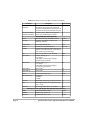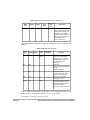
1
Z-12 Real-Time Sensor Operation & Reference Manual Ashtech 1170 Kifer Road Sunnyvale, CA USA 94086 Phone and Fax Numbers • Main • Voice: 408-524-1400 • Fax: 408-524-1500 • Sales • US: 800-922-2401 • International: 408-524-1670 • Fax: 408-524-1500 • Europe • Voice: 44-993-883-533 • Fax: 44-993-883-977 • Support • US: 800-229-2400 • International: 408-524-1680 • Fax: 408-524-1500 • BBS • Direct: 408-524-1527 Internet • • [email protected] http://www.ashtech.com Copyright Notice All rights reserved. No part of this publication or the computer program s described in it may be reproduced, translated, stored in a retrieval system, or transmitted in any form or by any means, electronic, mechanical photocopying, recording, or otherwise, without prior written permission of Ashtech Inc. Your rights with regard to this publication and the computer programs are subject to the restrictions and limitations imposed by the copyright laws of the United States of America and/or the jurisdiction in which you are located. For information on translations and distribution outside the U .S.A., please contact Ashtech Inc. NO PATENT OR COPYRIGHT LIABILITY IS ASSUMED WITH RESPECT TO THE USE OF INFORMATION CONTAINED HEREIN. WHILE REASONABLE PRECAUTIONS HAVE BEEN TAKEN IN THE PREPARATION OF THIS PUBLICATION, ASHTECH ASSUMES NO RESPONSIBILITY FOR ERRORS OR OMISSIONS, NOR IS ANY LIABILITY ASSUMED FOR DAMAGES RESULTING FROM THE USE OF THE INFORMATION CONTAINED HEREIN. FURTHER, THIS PUBLICATION AND FEATURES DESCRIBED HEREIN ARE SUBJECT TO CHANGE WITHOUT NOTICE. UNLESS OTHERWISE NOTED, ALL TRADEMARKS USED HEREIN ARE THE PROPERTY OF THE RESPECTIVE COMPANIES. Printed in the United States of America. © Copyright September 1996 Ashtech Part Number: 630076, Revision A Page ii Z-12 Real-Time Sensor Operation and Reference Manual Trademarks Z-12 Real-Time Sensor and the Ashtech logo are tradem arks of Ashtech. All other product and brand names are trademarks or registered trademarks of their respective holders. User Notice FCC (CFR 47, Part 15.105), BS EN 55022: 1995 This equipment has been tested and found to comply with the limits for a Class A digital device, pursuant to FCC, CFR 47, Part 15 Rules, and Class A ITE (Inform ation Technology Equipment), pursuant to the European Standard EN 55022: 1995. These limits are designed to provide reasonable protection against harmful interference when the equipment is operated in a commercial environment. This equipment generates, uses, and can radiate radio frequency energy and, if not installed and used in accordance with the instruction manual, may cause harmful interference to radio communications. Manufacturer provided or recommended shielded input/output cables must be used for this equipment to comply with the regulation limits tested. Operation of this equipment in a residential area is likely to cause harmful interference in which case the user will be required to correct the interference at his own expense. Changes or modifications to the equipment or cables not specifically approved, in writing, by the manufacturer m ay void the user’s authority to operate this equipm ent. Page iii Page iv Z-12 Real-Time Sensor Operation and Reference Manual Table of Contents Chapter 1. Introduction . . . . . . . . . . . . . . . . . . . . . . . . . . . . . . . . . . . . . . . . . . . . . . 1 Chapter 2. Operation . . . . . . . . . . . . . . . . . . . . . . . . . . . . . . . . . . . . . . . . . . . . . . . . 7 Equipment Description . . . . . . . . . . . . . . . . . . . . . . . . . . . . . . . . . . . . . . . . . . . . 7 Antenna . . . . . . . . . . . . . . . . . . . . . . . . . . . . . . . . . . . . . . . . . . . . . . . . . . . . 7 Sensor . . . . . . . . . . . . . . . . . . . . . . . . . . . . . . . . . . . . . . . . . . . . . . . . . . . . . . 8 Front Panel . . . . . . . . . . . . . . . . . . . . . . . . . . . . . . . . . . . . . . . . . . . . . . 8 RF Connector . . . . . . . . . . . . . . . . . . . . . . . . . . . . . . . . . . . . . . . . . . . . 9 Power Input Connections . . . . . . . . . . . . . . . . . . . . . . . . . . . . . . . . . . 10 Serial Port Configuration . . . . . . . . . . . . . . . . . . . . . . . . . . . . . . . . . . 11 Serial Null Modem Data Cable . . . . . . . . . . . . . . . . . . . . . . . . . . . . . . . . . 13 Default Parameters . . . . . . . . . . . . . . . . . . . . . . . . . . . . . . . . . . . . . . . . . . . 13 Data Output Options . . . . . . . . . . . . . . . . . . . . . . . . . . . . . . . . . . . . . . 14 Configuration Defaults . . . . . . . . . . . . . . . . . . . . . . . . . . . . . . . . . . . . 14 Getting Started . . . . . . . . . . . . . . . . . . . . . . . . . . . . . . . . . . . . . . . . . . . . . . . . . . 14 Hardware Setup . . . . . . . . . . . . . . . . . . . . . . . . . . . . . . . . . . . . . . . . . . . . . 14 Powering On the Sensor . . . . . . . . . . . . . . . . . . . . . . . . . . . . . . . . . . . . . . . 15 Receiver Memory Reset . . . . . . . . . . . . . . . . . . . . . . . . . . . . . . . . . . . . . . . 16 Communication with the Sensor . . . . . . . . . . . . . . . . . . . . . . . . . . . . . . . . 16 Monitoring Satellite Tracking . . . . . . . . . . . . . . . . . . . . . . . . . . . . . . . . . . 17 Monitoring Position . . . . . . . . . . . . . . . . . . . . . . . . . . . . . . . . . . . . . . . . . . 17 Differential Setup . . . . . . . . . . . . . . . . . . . . . . . . . . . . . . . . . . . . . . . . . . . . . . . 19 Hard-wired data link . . . . . . . . . . . . . . . . . . . . . . . . . . . . . . . . . . . . . . . . . . 19 Hardware Setup . . . . . . . . . . . . . . . . . . . . . . . . . . . . . . . . . . . . . . . . . . . . . 20 Entering Base Station Coordinates . . . . . . . . . . . . . . . . . . . . . . . . . . . . . . . 20 Entering Known Coordinates . . . . . . . . . . . . . . . . . . . . . . . . . . . . . . . 20 What if the Base Coordinates are Unknown? . . . . . . . . . . . . . . . . . . . 21 Table of Contents Page v Reliance Fundamentals Overview . . . . . . . . . . . . . . . . . . . . . . . . . . . . . . . . . . . . . . . . . . . . . . . . . . . . . . . 1 Functional Description . . . . . . . . . . . . . . . . . . . . . . . . . . . . . . . . . . . . . . . . . 2 Real-Time Differential . . . . . . . . . . . . . . . . . . . . . . . . . . . . . . . . . . . . . 3 Data Collection for Post-Processing . . . . . . . . . . . . . . . . . . . . . . . . . . . 4 Equipment . . . . . . . . . . . . . . . . . . . . . . . . . . . . . . . . . . . . . . . . . . . . . . . . . . 4 Standard . . . . . . . . . . . . . . . . . . . . . . . . . . . . . . . . . . . . . . . . . . . . . . . . 4 Optional . . . . . . . . . . . . . . . . . . . . . . . . . . . . . . . . . . . . . . . . . . . . . . . . . 4 Specifications and Options . . . . . . . . . . . . . . . . . . . . . . . . . . . . . . . . . . . . . . . . . 5 Technical Specifications . . . . . . . . . . . . . . . . . . . . . . . . . . . . . . . . . . . . . . . 5 Optional Features . . . . . . . . . . . . . . . . . . . . . . . . . . . . . . . . . . . . . . . . . . . . . 5 Memory Options . . . . . . . . . . . . . . . . . . . . . . . . . . . . . . . . . . . . . . . . . . 6 CPD with DBEN message . . . . . . . . . . . . . . . . . . . . . . . . . . . . . . . . . . . . . Base Setup . . . . . . . . . . . . . . . . . . . . . . . . . . . . . . . . . . . . . . . . . . . . . Rover/Remote Setup . . . . . . . . . . . . . . . . . . . . . . . . . . . . . . . . . . . . . RTCM Differential Setup . . . . . . . . . . . . . . . . . . . . . . . . . . . . . . . . . . . . . CPD with RTCM-RTK type 18/19 message . . . . . . . . . . . . . . . . . . . . . . . Base Setup . . . . . . . . . . . . . . . . . . . . . . . . . . . . . . . . . . . . . . . . . . . . . Rover/Remote Setup . . . . . . . . . . . . . . . . . . . . . . . . . . . . . . . . . . . . . RTCM differential (pseudo-range) with type 1 message . . . . . . . . . . . . . Base Setup . . . . . . . . . . . . . . . . . . . . . . . . . . . . . . . . . . . . . . . . . . . . . Rover/Remote Setup . . . . . . . . . . . . . . . . . . . . . . . . . . . . . . . . . . . . . Position Update Rate Configuration . . . . . . . . . . . . . . . . . . . . . . . . . . . . . . . . . 21 21 23 23 25 25 26 27 27 28 29 Chapter 3. Understanding CPD . . . . . . . . . . . . . . . . . . . . . . . . . . . . . . . . . . . . . . 31 Monitoring the CPD Rover Solution . . . . . . . . . . . . . . . . . . . . . . . . . . . . . . . . 31 How to tell if the integer ambiguities are fixed? . . . . . . . . . . . . . . . . . . . . 31 Solution Latency . . . . . . . . . . . . . . . . . . . . . . . . . . . . . . . . . . . . . . . . . . . . 32 Data Link Monitor . . . . . . . . . . . . . . . . . . . . . . . . . . . . . . . . . . . . . . . . . . . 32 CPD Solution Output and Storage . . . . . . . . . . . . . . . . . . . . . . . . . . . . . . . 32 Real-time Solution Output . . . . . . . . . . . . . . . . . . . . . . . . . . . . . . . . . . . . . 32 Vector Solution Output . . . . . . . . . . . . . . . . . . . . . . . . . . . . . . . . . . . . . . . 33 Solution Storage . . . . . . . . . . . . . . . . . . . . . . . . . . . . . . . . . . . . . . . . . . . . 34 Troubleshooting . . . . . . . . . . . . . . . . . . . . . . . . . . . . . . . . . . . . . . . . . . . . . . . . 35 System Performance Optimization . . . . . . . . . . . . . . . . . . . . . . . . . . . . . . . . . . 37 CPD Solution Parameters . . . . . . . . . . . . . . . . . . . . . . . . . . . . . . . . . . . . . 37 Ambiguity Fix: $PASHS,CPD,AFP . . . . . . . . . . . . . . . . . . . . . . . . . . 37 Dynamics: $PASHS,CPD,DYN . . . . . . . . . . . . . . . . . . . . . . . . . . . . . 38 Fast CPD: $PASHS,CPD,FST . . . . . . . . . . . . . . . . . . . . . . . . . . . . . . 39 Multipath: $PASHS,CPD,MTP . . . . . . . . . . . . . . . . . . . . . . . . . . . . . 39 DBEN Message Interval: $PASHS,CPD, PED and CPD Update Rate: $PASHS,CPD,PER . . . . . . . . . . . . . . . . . . . . . . . . . . . . . . . . . . . . . . 39 Initialization: $PASHS,CPD,RST . . . . . . . . . . . . . . . . . . . . . . . . . . . 40 Base Position Coordinates Selection: $PASHS,CPD,UBS . . . . . . . . 40 Base Station Elevation Mask: $PASHS,ELM . . . . . . . . . . . . . . . . . . 40 Universal RTCM Base Station . . . . . . . . . . . . . . . . . . . . . . . . . . . . . . . . . . . . . 40 Chapter 4. Command Response Formats . . . . . . . . . . . . . . . . . . . . . . . . . . . . . . . 43 Overview . . . . . . . . . . . . . . . . . . . . . . . . . . . . . . . . . . . . . . . . . . . . . . . . . . . . . . General Sensor Commands . . . . . . . . . . . . . . . . . . . . . . . . . . . . . . . . . . . . Query Satellites with Received Almanac . . . . . . . . . . . . . . . . . . . . . . Set Altitude of Antenna, Altitude Hold Fix . . . . . . . . . . . . . . . . . . . . Set Antenna Height . . . . . . . . . . . . . . . . . . . . . . . . . . . . . . . . . . . . . . Set Antenna Offsets . . . . . . . . . . . . . . . . . . . . . . . . . . . . . . . . . . . . . . Query Antenna Parameters . . . . . . . . . . . . . . . . . . . . . . . . . . . . . . . . . Page vi 43 50 52 52 53 53 54 Z-12 Real-Time Sensor Operation and Reference Manual Select Character or String Response to Set Command . . . . . . . . . . . . 55 Query Sensor Configuration . . . . . . . . . . . . . . . . . . . . . . . . . . . . . . . . 55 Query Receiver Current Segment Number . . . . . . . . . . . . . . . . . . . . . 56 Store String . . . . . . . . . . . . . . . . . . . . . . . . . . . . . . . . . . . . . . . . . . . . . 56 Query File Directory . . . . . . . . . . . . . . . . . . . . . . . . . . . . . . . . . . . . . . 56 Configure Receiver in Daisy Chain Mode . . . . . . . . . . . . . . . . . . . . . 57 Set Elevation Mask . . . . . . . . . . . . . . . . . . . . . . . . . . . . . . . . . . . . . . . 58 Set Static Site Occupation Counter . . . . . . . . . . . . . . . . . . . . . . . . . . . 58 Close or Delete File . . . . . . . . . . . . . . . . . . . . . . . . . . . . . . . . . . . . . . . 58 Set Altitude-Fixed Mode . . . . . . . . . . . . . . . . . . . . . . . . . . . . . . . . . . . 59 Request File Information . . . . . . . . . . . . . . . . . . . . . . . . . . . . . . . . . . 59 Set HDOP Mask . . . . . . . . . . . . . . . . . . . . . . . . . . . . . . . . . . . . . . . . . 61 Reset Receiver Memory and Communication Parameters. . . . . . . . . 61 Select Ionospheric Model . . . . . . . . . . . . . . . . . . . . . . . . . . . . . . . . . . 62 Query Ionospheric Data . . . . . . . . . . . . . . . . . . . . . . . . . . . . . . . . . . . 62 Set Latitude of Antenna Position . . . . . . . . . . . . . . . . . . . . . . . . . . . . 62 Set Longitude of Antenna Position . . . . . . . . . . . . . . . . . . . . . . . . . . . 63 Set Photogrammetry Edge . . . . . . . . . . . . . . . . . . . . . . . . . . . . . . . . . 65 Select CPD processing cycle . . . . . . . . . . . . . . . . . . . . . . . . . . . . . . . . 65 Set Minimum Satellites . . . . . . . . . . . . . . . . . . . . . . . . . . . . . . . . . . . . 65 Set PDOP Mask . . . . . . . . . . . . . . . . . . . . . . . . . . . . . . . . . . . . . . . . . 66 Set Position Elevation Mask . . . . . . . . . . . . . . . . . . . . . . . . . . . . . . . 66 Photogrammetry (Event Marker) and 1 PPS Com mands . . . . . . . . . . 66 Log Project Data . . . . . . . . . . . . . . . . . . . . . . . . . . . . . . . . . . . . . . . . . 66 Set Position Mode . . . . . . . . . . . . . . . . . . . . . . . . . . . . . . . . . . . . . . . . 67 Set Position of the Antenna . . . . . . . . . . . . . . . . . . . . . . . . . . . . . . . . . 67 Query Port and Baud Rate . . . . . . . . . . . . . . . . . . . . . . . . . . . . . . . . . 69 Set Receiver To Sleep Mode . . . . . . . . . . . . . . . . . . . . . . . . . . . . . . . . 69 Reboot . . . . . . . . . . . . . . . . . . . . . . . . . . . . . . . . . . . . . . . . . . . . . . . . . 70 Set Recording Interval . . . . . . . . . . . . . . . . . . . . . . . . . . . . . . . . . . . . 70 Query Radio Mode Parameters . . . . . . . . . . . . . . . . . . . . . . . . . . . . . . 70 Turn Data Recording On/Off . . . . . . . . . . . . . . . . . . . . . . . . . . . . . . . 71 Query Sensor (Receiver) ID . . . . . . . . . . . . . . . . . . . . . . . . . . . . . . . . 71 Set Type of Data . . . . . . . . . . . . . . . . . . . . . . . . . . . . . . . . . . . . . . . . . 72 Reset Parameters To Factory Defaults. . . . . . . . . . . . . . . . . . . . . . . . . 72 Upload Route Information . . . . . . . . . . . . . . . . . . . . . . . . . . . . . . . . . 77 Save Parameters . . . . . . . . . . . . . . . . . . . . . . . . . . . . . . . . . . . . . . . . . 77 Query Sensor Configuration . . . . . . . . . . . . . . . . . . . . . . . . . . . . . . . . 77 Enter Site ID . . . . . . . . . . . . . . . . . . . . . . . . . . . . . . . . . . . . . . . . . . . . 78 Set Communication Baud Rate . . . . . . . . . . . . . . . . . . . . . . . . . . . . . . 78 Query Elapsed Time for Each Tracked SV Since Positioning Began 79 Query Status of Currently Locked Satellites . . . . . . . . . . . . . . . . . . . . 80 Table of Contents Page vii Query SV Mode Selection . . . . . . . . . . . . . . . . . . . . . . . . . . . . . . . . . 80 Use Unheathy SVs . . . . . . . . . . . . . . . . . . . . . . . . . . . . . . . . . . . . . . . 80 Designate Satellites to Use . . . . . . . . . . . . . . . . . . . . . . . . . . . . . . . . . 81 Set VDOP Mask . . . . . . . . . . . . . . . . . . . . . . . . . . . . . . . . . . . . . . . . . 81 Query Week Number . . . . . . . . . . . . . . . . . . . . . . . . . . . . . . . . . . . . . 81 Upload Waypoint to Sensor . . . . . . . . . . . . . . . . . . . . . . . . . . . . . . . . 81 Set Sensor to Z Mode . . . . . . . . . . . . . . . . . . . . . . . . . . . . . . . . . . . . . 82 Raw Data Commands . . . . . . . . . . . . . . . . . . . . . . . . . . . . . . . . . . . . . . . . 83 Select BEN Output Format . . . . . . . . . . . . . . . . . . . . . . . . . . . . . . . . 83 Query CBEN Message . . . . . . . . . . . . . . . . . . . . . . . . . . . . . . . . . . . . 84 Enable/Disable Real-Time Output . . . . . . . . . . . . . . . . . . . . . . . . . . . 85 Query Vector Solution . . . . . . . . . . . . . . . . . . . . . . . . . . . . . . . . . . . . 85 Enable/Disable Real-Time Data Output . . . . . . . . . . . . . . . . . . . . . . . 87 Query PBEN Data for One Epoch . . . . . . . . . . . . . . . . . . . . . . . . . . . 88 Query Raw Data Parameters . . . . . . . . . . . . . . . . . . . . . . . . . . . . . . . 89 Query UBN Message . . . . . . . . . . . . . . . . . . . . . . . . . . . . . . . . . . . . . 90 NMEA Data Message Commands . . . . . . . . . . . . . . . . . . . . . . . . . . . . . . . 93 Disable All NMEA Messages . . . . . . . . . . . . . . . . . . . . . . . . . . . . . . 95 NMEA Almanac . . . . . . . . . . . . . . . . . . . . . . . . . . . . . . . . . . . . . . . . . 95 Autopilot Message . . . . . . . . . . . . . . . . . . . . . . . . . . . . . . . . . . . . . . . 96 NMEA Bearing and Distance . . . . . . . . . . . . . . . . . . . . . . . . . . . . . . . 97 NMEA Decimal Almanac Message . . . . . . . . . . . . . . . . . . . . . . . . . . 98 GGA (GPS Position) Message . . . . . . . . . . . . . . . . . . . . . . . . . . . . . . 99 GLL (Latitude,Longitude) . . . . . . . . . . . . . . . . . . . . . . . . . . . . . . . . 101 NMEA GRS (Satellite Range Residual) . . . . . . . . . . . . . . . . . . . . . 102 NMEA DOP and Active Satellite Message . . . . . . . . . . . . . . . . . . . 104 NMEA GSN (Signal Strength/Satellite Number) . . . . . . . . . . . . . . 105 NMEA GSV (Satellites-In-View) . . . . . . . . . . . . . . . . . . . . . . . . . . 106 NMEA GXP (Position Horizontal) . . . . . . . . . . . . . . . . . . . . . . . . . 108 NMEA MSG (RTCM) Message . . . . . . . . . . . . . . . . . . . . . . . . . . . 109 Set NMEA Send Interval . . . . . . . . . . . . . . . . . . . . . . . . . . . . . . . . . 114 RRE (Satellite Residual and Position Error) Message . . . . . . . . . . . 114 NMEA SAT (Satellite Status) Message . . . . . . . . . . . . . . . . . . . . . . 116 NMEA TTT (Event Marker) Message . . . . . . . . . . . . . . . . . . . . . . . 117 NMEA TTT (Event Marker) Message . . . . . . . . . . . . . . . . . . . . . . . 118 NMEA VTG (Velocity/Course) Message . . . . . . . . . . . . . . . . . . . . 119 NMEA Message VTG (COG/SOG) . . . . . . . . . . . . . . . . . . . . . . . . . 121 NMEA Cross-Track Error . . . . . . . . . . . . . . . . . . . . . . . . . . . . . . . . 121 RTCM Commands . . . . . . . . . . . . . . . . . . . . . . . . . . . . . . . . . . . . . . . . . . 123 Turn Auto Differential Mode On/Off . . . . . . . . . . . . . . . . . . . . . . . . 123 Set Receiver as Differential Base Station . . . . . . . . . . . . . . . . . . . . 124 Select Pseudo-Range for RTCM Differential . . . . . . . . . . . . . . . . . 124 Page viii Z-12 Real-Time Sensor Operation and Reference Manual Select Type Of EOT Character for RTCM Message . . . . . . . . . . . . 125 Compatible RTCM Message 18/19 Format . . . . . . . . . . . . . . . . . . . 125 Initialize RTCM Setup . . . . . . . . . . . . . . . . . . . . . . . . . . . . . . . . . . . 125 Set Maximum Age of RTCM Differential Corrections . . . . . . . . . . 125 Define RTCM Message . . . . . . . . . . . . . . . . . . . . . . . . . . . . . . . . . . 126 Disable Differential Mode . . . . . . . . . . . . . . . . . . . . . . . . . . . . . . . . 126 Set Quality Threshold . . . . . . . . . . . . . . . . . . . . . . . . . . . . . . . . . . . . 126 Set Sensor as Differential Remote . . . . . . . . . . . . . . . . . . . . . . . . . . 126 Check Sequence Number . . . . . . . . . . . . . . . . . . . . . . . . . . . . . . . . . 127 Set RTCM Bit Rate . . . . . . . . . . . . . . . . . . . . . . . . . . . . . . . . . . . . . . 127 Set Station Identification . . . . . . . . . . . . . . . . . . . . . . . . . . . . . . . . . . 127 Set Health of Reference Station . . . . . . . . . . . . . . . . . . . . . . . . . . . . 128 Enable Type of Message . . . . . . . . . . . . . . . . . . . . . . . . . . . . . . . . . . 128 Query Differential Mode Param eters and Status . . . . . . . . . . . . . . . 129 Query RTCM Remote Station Status . . . . . . . . . . . . . . . . . . . . . . . . 131 CPD Commands . . . . . . . . . . . . . . . . . . . . . . . . . . . . . . . . . . . . . . . . . . . . 132 Set Integer Am biguity Param eter . . . . . . . . . . . . . . . . . . . . . . . . . . . 133 Set Antenna Parameters Of Other Receiver . . . . . . . . . . . . . . . . . . . 133 Query Data Link Status . . . . . . . . . . . . . . . . . . . . . . . . . . . . . . . . . . . 134 Set Rover Dynamics . . . . . . . . . . . . . . . . . . . . . . . . . . . . . . . . . . . . . 135 Set Current Raw Position . . . . . . . . . . . . . . . . . . . . . . . . . . . . . . . . . 136 Select Type Of EOT Character, DBEN Message . . . . . . . . . . . . . . 136 Enable/Disable Fast CPD Mode . . . . . . . . . . . . . . . . . . . . . . . . . . . . 137 Display CPD SV Information . . . . . . . . . . . . . . . . . . . . . . . . . . . . . . 137 CPD Mode Select . . . . . . . . . . . . . . . . . . . . . . . . . . . . . . . . . . . . . . . 138 Select CPD processing cycle . . . . . . . . . . . . . . . . . . . . . . . . . . . . . . . 140 Set Multipath Parameters . . . . . . . . . . . . . . . . . . . . . . . . . . . . . . . . . 140 Select Solution to Output . . . . . . . . . . . . . . . . . . . . . . . . . . . . . . . . . 140 Set CPD Update Interval . . . . . . . . . . . . . . . . . . . . . . . . . . . . . . . . . . 141 Set BPD Transmission Period . . . . . . . . . . . . . . . . . . . . . . . . . . . . . . 141 Set DBEN Transmission Period . . . . . . . . . . . . . . . . . . . . . . . . . . . . 142 Set Reference Position of Other Receiver . . . . . . . . . . . . . . . . . . . . . 142 Reset CPD Processing . . . . . . . . . . . . . . . . . . . . . . . . . . . . . . . . . . . . 143 Select Output Port for DBEN and BPS Messages . . . . . . . . . . . . . . 144 CPD Status . . . . . . . . . . . . . . . . . . . . . . . . . . . . . . . . . . . . . . . . . . . . 144 Query CPD Solution Status . . . . . . . . . . . . . . . . . . . . . . . . . . . . . . . . 146 Select Base Position - Rover . . . . . . . . . . . . . . . . . . . . . . . . . . . . . . . 146 Display Station Coordinates . . . . . . . . . . . . . . . . . . . . . . . . . . . . . . . 147 Set DBEN Message and Sender/Destination ID . . . . . . . . . . . . . . . . 149 Query Sensor ID and DBEN Message Type . . . . . . . . . . . . . . . . . . . 150 Packed DBEN . . . . . . . . . . . . . . . . . . . . . . . . . . . . . . . . . . . . . . . . . . 150 Report Real-Time Error . . . . . . . . . . . . . . . . . . . . . . . . . . . . . . . . . . 152 Table of Contents Page ix Appendix A. Photogrammtery & Event Marker . . . . . . . . . . . . . . . . . . . . . . . . . . A-1 Photogrammetry (Event Marking) Interfaces . . . . . . . . . . . . . . . . . . . . . . . . . A-1 Time Tagging the Shutter Signal . . . . . . . . . . . . . . . . . . . . . . . . . . . A-2 Appendix B. Radio Link . . . . . . . . . . . . . . . . . . . . . . . . . . . . . . . . . . . . . . . . . . . . B-1 Data Transmission Rate . . . . . . . . . . . . . . . . . . . . . . . . . . . . . . . . . . . . . . . . . B-1 Line-of-Sight Transmission . . . . . . . . . . . . . . . . . . . . . . . . . . . . . . . . . . . . . . B-1 Sensitivity . . . . . . . . . . . . . . . . . . . . . . . . . . . . . . . . . . . . . . . . . . . . . . . . . . . . B-2 Appendix C. Differential GPS . . . . . . . . . . . . . . . . . . . . . . . . . . . . . . . . . . . . . . . C-1 Fundamentals of Differential GPS . . . . . . . . . . . . . . . . . . . . . . . . . . . . . . . . . Code Based Differential . . . . . . . . . . . . . . . . . . . . . . . . . . . . . . . . . . . . . . . . . Carrier Phase Differential (CPD) . . . . . . . . . . . . . . . . . . . . . . . . . . . . . . . . . . On-the-Fly Ambiguity Resolution . . . . . . . . . . . . . . . . . . . . . . . . . . . . . . Fast Carrier Phase Differential . . . . . . . . . . . . . . . . . . . . . . . . . . . . . . . . Vector and Reverse Vector Processing . . . . . . . . . . . . . . . . . . . . . . . . . . Sources of Error . . . . . . . . . . . . . . . . . . . . . . . . . . . . . . . . . . . . . . . . . . . . . . . Sensor Related Errors . . . . . . . . . . . . . . . . . . . . . . . . . . . . . . . . . . . . . . . GPS Signal Multipath . . . . . . . . . . . . . . . . . . . . . . . . . . . . . . . . . . . . Satellite Geometry . . . . . . . . . . . . . . . . . . . . . . . . . . . . . . . . . . . . . . Maintaining Lock to the Satellites . . . . . . . . . . . . . . . . . . . . . . . . . . Carrier Phase Integer Am biguities . . . . . . . . . . . . . . . . . . . . . . . . . . Data Link Related Errors . . . . . . . . . . . . . . . . . . . . . . . . . . . . . . . . . . . . . Radio Link Dropout . . . . . . . . . . . . . . . . . . . . . . . . . . . . . . . . . . . . . Selective Availability . . . . . . . . . . . . . . . . . . . . . . . . . . . . . . . . . . . . Differential Message . . . . . . . . . . . . . . . . . . . . . . . . . . . . . . . . . . . . . . . . . . . . C-1 C-1 C-2 C-2 C-2 C-2 C-3 C-3 C-3 C-4 C-4 C-4 C-4 C-4 C-5 C-5 Glossary . . . . . . . . . . . . . . . . . . . . . . . . . . . . . . . . . . . . . . . . . . . . . . . . . . . . . . Gloss-1 Index. . . . . . . . . . . . . . . . . . . . . . . . . . . . . . . . . . . . . . . . . . . . . . . . . . . . . . . . . Index-1 Page x Z-12 Real-Time Sensor Operation and Reference Manual List of Figures List of Figures Z-12 Real-Time Sensor. . . . . . . . . . . . . . . . . . . . . . . . . . . . . . . . . . 2 Typical GPS Antenna . . . . . . . . . . . . . . . . . . . . . . . . . . . . . . . . . . . 7 Z-12 Real-Time Sensor Front Panel . . . . . . . . . . . . . . . . . . . . . . . . 8 Power Connector pin layout . . . . . . . . . . . . . . . . . . . . . . . . . . . . . 10 DB9 Pin Configuration . . . . . . . . . . . . . . . . . . . . . . . . . . . . . . . . . 11 Null Modem Data Cable. . . . . . . . . . . . . . . . . . . . . . . . . . . . . . . . 13 Equipment cable connections in Differential Setup . . . . . . . . . . . 15 Ambiguity Fix Test Results . . . . . . . . . . . . . . . . . . . . . . . . . . . . . 38 Photogrammetry Time Measurement . . . . . . . . . . . . . . . . . . . . . A-1 Page xi Reliance Fundamentals Figure 1.1: Figure 2.1: Figure 2.2: Figure 2.3: Figure 2.4: Figure 2.5: Figure 2.6: Figure 3.1: Figure A.1: Page xii Z-12 Real-Time Sensor Operation and Reference Manual List of Tables List of Tables Accuracy as Function of Mode. . . . . . . . . . . . . . . . . . . . . . . . . . . . 3 Technical Specifications . . . . . . . . . . . . . . . . . . . . . . . . . . . . . . . . . 5 Sensor Options . . . . . . . . . . . . . . . . . . . . . . . . . . . . . . . . . . . . . . . . 6 Memory Options . . . . . . . . . . . . . . . . . . . . . . . . . . . . . . . . . . . . . . . 6 Z-12 Real-Time Sensor Front Panel . . . . . . . . . . . . . . . . . . . . . . . . 9 Power Connector Pinouts . . . . . . . . . . . . . . . . . . . . . . . . . . . . . . . 10 DB9 RS-232 Connector Pinouts. . . . . . . . . . . . . . . . . . . . . . . . . . 12 Operating Configuration Defaults . . . . . . . . . . . . . . . . . . . . . . . . 14 GGA Response Message Structure. . . . . . . . . . . . . . . . . . . . . . . . 18 RTCM Message Types . . . . . . . . . . . . . . . . . . . . . . . . . . . . . . . . . 24 Differential RTCM Message Types . . . . . . . . . . . . . . . . . . . . . . . 24 MSMOD data description . . . . . . . . . . . . . . . . . . . . . . . . . . . . . . . 29 Troubleshooting Tips . . . . . . . . . . . . . . . . . . . . . . . . . . . . . . . . . . 35 CPD optimization commands . . . . . . . . . . . . . . . . . . . . . . . . . . . . 37 Default RTCM message schedules. . . . . . . . . . . . . . . . . . . . . . . . 41 Command Summary . . . . . . . . . . . . . . . . . . . . . . . . . . . . . . . . . . . 44 General Sensor Commands. . . . . . . . . . . . . . . . . . . . . . . . . . . . . . 50 ALH Structure. . . . . . . . . . . . . . . . . . . . . . . . . . . . . . . . . . . . . . . . 52 ANT Structure. . . . . . . . . . . . . . . . . . . . . . . . . . . . . . . . . . . . . . . . 53 Typical ANT Command . . . . . . . . . . . . . . . . . . . . . . . . . . . . . . . . 54 Antenna Parameters . . . . . . . . . . . . . . . . . . . . . . . . . . . . . . . . . . . 54 ACK/NAK Response Messages . . . . . . . . . . . . . . . . . . . . . . . . . . 55 DIR Response Structure . . . . . . . . . . . . . . . . . . . . . . . . . . . . . . . . 57 Daisy Chain (DSY) Structure . . . . . . . . . . . . . . . . . . . . . . . . . . . . 57 FIL Structure. . . . . . . . . . . . . . . . . . . . . . . . . . . . . . . . . . . . . . . . . 59 FLS Structure . . . . . . . . . . . . . . . . . . . . . . . . . . . . . . . . . . . . . . . . 60 Typical FLS Message . . . . . . . . . . . . . . . . . . . . . . . . . . . . . . . . . . 60 Memory Reset Codes . . . . . . . . . . . . . . . . . . . . . . . . . . . . . . . . . . 61 Typical PAR Response Message . . . . . . . . . . . . . . . . . . . . . . . . . 63 PJT Structure. . . . . . . . . . . . . . . . . . . . . . . . . . . . . . . . . . . . . . . . . 66 POS Command Structure . . . . . . . . . . . . . . . . . . . . . . . . . . . . . . . 67 POS Message Structure . . . . . . . . . . . . . . . . . . . . . . . . . . . . . . . . 68 Baud Rate Indexes . . . . . . . . . . . . . . . . . . . . . . . . . . . . . . . . . . . . 69 RCI Structure . . . . . . . . . . . . . . . . . . . . . . . . . . . . . . . . . . . . . . . . 70 RDP Structure. . . . . . . . . . . . . . . . . . . . . . . . . . . . . . . . . . . . . . . . 71 Parameters Reset by RST Command . . . . . . . . . . . . . . . . . . . . . . 73 RTE Structure . . . . . . . . . . . . . . . . . . . . . . . . . . . . . . . . . . . . . . . . 77 Configuration and Options . . . . . . . . . . . . . . . . . . . . . . . . . . . . . . 77 Page xiii Reliance Fundamentals Table 1.1: Table 1.2: Table 1.3: Table 1.4: Table 2.1: Table 2.2: Table 2.3: Table 2.4: Table 2.5: Table 2.6: Table 2.7: Table 2.8: Table 3.1: Table 3.2: Table 3.3: Table 4.1: Table 4.2: Table 4.3: Table 4.4: Table 4.5: Table 4.6: Table 4.7: Table 4.8: Table 4.9: Table 4.10: Table 4.11: Table 4.12: Table 4.13: Table 4.14: Table 4.15: Table 4.16: Table 4.17: Table 4.18: Table 4.19: Table 4.20: Table 4.21: Table 4.22: Table 4.23: Table 4.24: Table 4.25: Table 4.26: Table 4.27: Table 4.28: Table 4.29: Table 4.30: Table 4.31: Table 4.32: Table 4.33: Table 4.34: Table 4.35: Table 4.36: Table 4.37: Table 4.38: Table 4.39: Table 4.40: Table 4.41: Table 4.42: Table 4.43: Table 4.44: Table 4.45: Table 4.46: Table 4.47: Table 4.48: Table 4.49: Table 4.50: Table 4.51: Table 4.52: Table 4.53: Table 4.54: Table 4.55: Table 4.56: Table 4.57: Table 4.58: Table 4.59: Table 4.60: Table 4.61: Table 4.62: Table 4.63: Table 4.64: Table 4.65: Page xiv Communication Baud Rate . . . . . . . . . . . . . . . . . . . . . . . . . . . . . 78 SRD Structure . . . . . . . . . . . . . . . . . . . . . . . . . . . . . . . . . . . . . . . 79 SVM Structure . . . . . . . . . . . . . . . . . . . . . . . . . . . . . . . . . . . . . . . 80 WPL Structure . . . . . . . . . . . . . . . . . . . . . . . . . . . . . . . . . . . . . . . 82 Raw Data Commands. . . . . . . . . . . . . . . . . . . . . . . . . . . . . . . . . . 83 BEN Command Structure . . . . . . . . . . . . . . . . . . . . . . . . . . . . . . 83 Epoch Information Structure . . . . . . . . . . . . . . . . . . . . . . . . . . . . 84 DSM Structure . . . . . . . . . . . . . . . . . . . . . . . . . . . . . . . . . . . . . . . 85 OBN (Binary Data) Structure. . . . . . . . . . . . . . . . . . . . . . . . . . . . 86 Real-Time Data Output Data Types. . . . . . . . . . . . . . . . . . . . . . . 88 PBEN Data structure . . . . . . . . . . . . . . . . . . . . . . . . . . . . . . . . . . 89 RAW Message Structure . . . . . . . . . . . . . . . . . . . . . . . . . . . . . . . 90 UBN Structure . . . . . . . . . . . . . . . . . . . . . . . . . . . . . . . . . . . . . . . 91 UBN Response Structure . . . . . . . . . . . . . . . . . . . . . . . . . . . . . . . 91 NMEA Periods . . . . . . . . . . . . . . . . . . . . . . . . . . . . . . . . . . . . . . . 93 NMEA Data Message Commands. . . . . . . . . . . . . . . . . . . . . . . . 94 ALM Structure . . . . . . . . . . . . . . . . . . . . . . . . . . . . . . . . . . . . . . . 96 Autopilot APA Structure . . . . . . . . . . . . . . . . . . . . . . . . . . . . . . . 96 BWC Structure. . . . . . . . . . . . . . . . . . . . . . . . . . . . . . . . . . . . . . . 97 NMEA DAL Structure. . . . . . . . . . . . . . . . . . . . . . . . . . . . . . . . . 98 GGA Structure . . . . . . . . . . . . . . . . . . . . . . . . . . . . . . . . . . . . . . . 99 Typical GGA Response Message . . . . . . . . . . . . . . . . . . . . . . . 101 GLL Structure . . . . . . . . . . . . . . . . . . . . . . . . . . . . . . . . . . . . . . 102 Typical GLL Message . . . . . . . . . . . . . . . . . . . . . . . . . . . . . . . . 102 GRS Structure . . . . . . . . . . . . . . . . . . . . . . . . . . . . . . . . . . . . . . 103 Typical GRS Response Message . . . . . . . . . . . . . . . . . . . . . . . . 103 GPGSA Structure. . . . . . . . . . . . . . . . . . . . . . . . . . . . . . . . . . . . 104 GSN Structure . . . . . . . . . . . . . . . . . . . . . . . . . . . . . . . . . . . . . . 105 Typical GSN Message . . . . . . . . . . . . . . . . . . . . . . . . . . . . . . . . 105 GSV Structure . . . . . . . . . . . . . . . . . . . . . . . . . . . . . . . . . . . . . . 107 Typical GSV Message . . . . . . . . . . . . . . . . . . . . . . . . . . . . . . . . 107 Typical GXP Response Message . . . . . . . . . . . . . . . . . . . . . . . . 108 GXP Structure . . . . . . . . . . . . . . . . . . . . . . . . . . . . . . . . . . . . . . 109 Structure for RTCM Message Types 1 and 9 . . . . . . . . . . . . . . 110 Typical RTCM Message Types 1 and 9. . . . . . . . . . . . . . . . . . . 111 Structure for RTCM Message Type 3 . . . . . . . . . . . . . . . . . . . . 112 Typical RTCM Message Type 03 . . . . . . . . . . . . . . . . . . . . . . . 112 Structure for RTCM Message Types 6 and 16 . . . . . . . . . . . . . 113 Typical RTCM Message Types 6 and 16. . . . . . . . . . . . . . . . . . 113 RRE Structure . . . . . . . . . . . . . . . . . . . . . . . . . . . . . . . . . . . . . . 115 Typical RRE Response . . . . . . . . . . . . . . . . . . . . . . . . . . . . . . . 115 SAT Structure . . . . . . . . . . . . . . . . . . . . . . . . . . . . . . . . . . . . . . 116 Z-12 Real-Time Sensor Operation and Reference Manual Table 4.66: Table 4.67: Table 4.68: Table 4.69: Table 4.70: Table 4.71: Table 4.72: Table 4.73: Table 4.74: Table 4.75: Table 4.76: Table 4.77: Table 4.78: Table 4.79: Table 4.80: Table 4.81: Table 4.82: Table 4.83: Table 4.84: Table 4.85: Table 4.86: Table 4.87: Table 4.88: Table 4.89: Table 4.90: Table 4.91: Table 4.92: Table 4.93: Table 4.94: Table 4.95: Table 4.96: Table 4.97: Table 4.98: Table 4.99: Table 4.100: Table 4.101: Table 4.102: Table 4.103: Table 4.104: Table 4.105: Table 4.106: Table 4.107: List of Tables Typical SAT Message. . . . . . . . . . . . . . . . . . . . . . . . . . . . . . . . . 117 TTT Structure . . . . . . . . . . . . . . . . . . . . . . . . . . . . . . . . . . . . . . . 118 Typical TTT Message. . . . . . . . . . . . . . . . . . . . . . . . . . . . . . . . . 118 NMEA UTM Structure . . . . . . . . . . . . . . . . . . . . . . . . . . . . . . . . 118 VTG Structure. . . . . . . . . . . . . . . . . . . . . . . . . . . . . . . . . . . . . . . 120 Typical VTG Message . . . . . . . . . . . . . . . . . . . . . . . . . . . . . . . . 120 VTG Structure. . . . . . . . . . . . . . . . . . . . . . . . . . . . . . . . . . . . . . . 121 XTE Structure. . . . . . . . . . . . . . . . . . . . . . . . . . . . . . . . . . . . . . . 121 RTCM Commands . . . . . . . . . . . . . . . . . . . . . . . . . . . . . . . . . . . 123 MSG Message Structure . . . . . . . . . . . . . . . . . . . . . . . . . . . . . . . 124 Codes for Output Bit Rate . . . . . . . . . . . . . . . . . . . . . . . . . . . . . 127 Station Health Codes . . . . . . . . . . . . . . . . . . . . . . . . . . . . . . . . . 128 Types of RTCM Messages . . . . . . . . . . . . . . . . . . . . . . . . . . . . . 129 RTC Message Structure . . . . . . . . . . . . . . . . . . . . . . . . . . . . . . . 130 DFO Structure. . . . . . . . . . . . . . . . . . . . . . . . . . . . . . . . . . . . . . . 131 CPD Commands . . . . . . . . . . . . . . . . . . . . . . . . . . . . . . . . . . . . . 132 AFP Structure . . . . . . . . . . . . . . . . . . . . . . . . . . . . . . . . . . . . . . . 133 CPD ANT Structure . . . . . . . . . . . . . . . . . . . . . . . . . . . . . . . . . . 133 CPD,ANT Structure . . . . . . . . . . . . . . . . . . . . . . . . . . . . . . . . . . 134 DLK Message Structure . . . . . . . . . . . . . . . . . . . . . . . . . . . . . . . 135 CPD DYN Structure . . . . . . . . . . . . . . . . . . . . . . . . . . . . . . . . . . 136 CPD EOT Structure . . . . . . . . . . . . . . . . . . . . . . . . . . . . . . . . . . 136 Fast CPD Structure . . . . . . . . . . . . . . . . . . . . . . . . . . . . . . . . . . . 137 CPD INF Structure . . . . . . . . . . . . . . . . . . . . . . . . . . . . . . . . . . . 137 CPD MOD Command Structure. . . . . . . . . . . . . . . . . . . . . . . . . 138 CPD MOD Message Structure . . . . . . . . . . . . . . . . . . . . . . . . . . 139 MTP Stucture . . . . . . . . . . . . . . . . . . . . . . . . . . . . . . . . . . . . . . . 140 Solution Selection . . . . . . . . . . . . . . . . . . . . . . . . . . . . . . . . . . . . 141 PEB/PER Structure. . . . . . . . . . . . . . . . . . . . . . . . . . . . . . . . . . . 142 CPD or BPS POS Structure . . . . . . . . . . . . . . . . . . . . . . . . . . . . 142 CPD POS Structure. . . . . . . . . . . . . . . . . . . . . . . . . . . . . . . . . . . 143 CPD Status Message Structure . . . . . . . . . . . . . . . . . . . . . . . . . . 144 CPD STS Structure . . . . . . . . . . . . . . . . . . . . . . . . . . . . . . . . . . . 146 Base Position - Rover . . . . . . . . . . . . . . . . . . . . . . . . . . . . . . . . . 147 BPS Structure . . . . . . . . . . . . . . . . . . . . . . . . . . . . . . . . . . . . . . . 147 Status Flag. . . . . . . . . . . . . . . . . . . . . . . . . . . . . . . . . . . . . . . . . . 149 IDR Structure . . . . . . . . . . . . . . . . . . . . . . . . . . . . . . . . . . . . . . . 149 RPC Message Structure . . . . . . . . . . . . . . . . . . . . . . . . . . . . . . . 150 Packed Data Field Structure . . . . . . . . . . . . . . . . . . . . . . . . . . . . 150 PRN Data Structure . . . . . . . . . . . . . . . . . . . . . . . . . . . . . . . . . . 151 DBEN Message Size. . . . . . . . . . . . . . . . . . . . . . . . . . . . . . . . . . 152 Real-Time Error Codes (Hex). . . . . . . . . . . . . . . . . . . . . . . . . . . 152 Page xv Table C.1: Page xvi Differential Messages . . . . . . . . . . . . . . . . . . . . . . . . . . . . . . . . C-5 Z-12 Real-Time Sensor Operation and Reference Manual 1 Overview The Z-12 Real-Time Sensor, Figure 1.1, processes signals from the Global Positioning System (GPS) satellite constellation. The sensor provides real-time position, velocity, and time measurements using twelve dedicated separate and parallel channels for Coarse/ Acquisition (C/A) code-phase, and carrier-phase measurement on the L1 (1575 MHz), and Precise (P) code phase and carrier phase measurem ent on L1 and L2 (1227 MHz) bands. The sensor receives satellite signals via an L-band antenna and low-noise amplifier (LNA). The sensor operates stand-alone, and as a base (reference) station or rem ote (rover) station providing real-tim e differential GPS operation for code and real-tim e kinematic (RTK) operation for carrier phase. The sensor implements the RTCM SC 104 V2.2 standard for differential and RTK operation, including the newly defined message types 18 and 19. These features allow the sensor to achieve centim eter accuracy while Introduction Page 1 Reliance Fundamentals To satisfy real-time applications (such as construction machine control, vehicle guidance, precision navigation and surveying) requiring high accuracy, fast update rates, and low latency, we have developed the Z-12 Real-Time Sensor. Based on Ashtech’s RealTime Z™ technology, the Z-12 Real-Time Sensor has been upgraded to achieve faster position updates with latencies as low as 100ms. The Z-12 Real-Time Sensor calculates new positions independently, as fast as 5Hz. The system provides the fastest available initialization time, with ambiguity resolution of seconds in kinematic mode. Once initialized, users can have confidence in precise landforming, docking, or CAT IIIB aircraft landing, due to real-time accuracy at centimeter level. This performance comes with all the existing features that earned the Z-12 its reputation as the leading dual frequency receiver, including the Industry’s best: • Patented Z-tracking™ of satellites during periods of large ionospheric activity • Jam immunity • Speed and reliability of ambiguity resolution Introduction Introduction being compatible for differential and RTK operation with any other receiver that implements the RTCM standard. Figure 1.1: Z-12 Real-Time Sensor Functional Description The sensor is activated when power is applied to either of the two power connectors, and the power pushbutton is pushed to ON. After self test, the sensor initializes its 12 channels and begins searching for all satellites (SVs or Space Vehicles) within the field of view of the antenna. The sensor can track all Block I and Block II GPS SVs. All 32 PRN numbers as specified in Navstar GPS Space Segment/Navigation User Interfaces, ICD-GPS-200, Revision B are coded inside the sensor/processor card. As the sensor acquires (locks onto) each SV, it notes the time and then collects the ephemeris data about the orbit of that SV, and almanac data about the orbits of all the SVs in the constellation. The sensor features 12-parallel channel/12-SV all-in-view operation; each of up to 12 visible SVs can be assigned to a channel and then continuously tracked. Each SV Page 2 Z-12 Real-Time Sensor Operation and Reference Manual Real-Time Differential One of the most important functions of the sensor is providing real-time position solutions with accuracy ranging from centimeter level to 100 meters. Table 1.1 summarizes the positioning modes and expected accuracy. Table 1.1: Accuracy as Function of Mode Positioning Mode Introduction Tyhpical Horizontal Accuracy (rms), 5 SVs, PDOP<4 Maximum Update Rate Maximum Operating Range Autonomous 16 meters with SA off 1 Hz Anywhere RTCM differrential <1 meter 1 Hz Several hundred kilometers Real-time kinematic (RTK) carrier phase differential in RTCM-RTK format or DBEN format 0.01 meter or better 5 Hz <15 kilometers Page 3 Introduction broadcasts almanac and ephem eris information every 30 seconds, and the sensor automatically records this inform ation in its non-volatile mem ory. The sensor has an L1/L2-band radio frequency (RF) port and three RS-232 serial input/output (I/O) ports. Ports A and B are capable of two-way communication with external equipment. Port C is capable of RTCM operation. With external power removed from the non-volatile part of the RAM, data storage is maintained using an internal battery. The RF circuitry receives satellite data from a GPS antenna and LNA via a coaxial cable, and can supply power to the antenna/LNA by means of that cable. No separate antenna power cable is required. Power consumption is approximately 12 watts even when powering an LNA. The sensor incorporates a two-color LED which lights red to indicate the power status, and flashes green to indicate the number of SVs locked. The sensor collects Coarse Acquisition (C/A) code-phase (pseudo-range) and full wavelength carrier phase measurem ent on L1 frequency (1575 MHz), Precise (P) code phase (pseudo-range) and full wavelength carrier phase on L1 and L2 frequency (1227 MHz). The sensor permits uninterrupted use even when Anti-Spoofing (AS) is turned on. When AS is on, the sensor automatically activates Ashtech patented Ztracking mode that mitigates the effects of AS. The performance when AS is on is the same as when AS is off. Data Collection for Post-Processing One independent measurement is collected per 0.2, 0.5, 1.0 second, or slower, depending upon whether the Q (Quick Position) option is installed in the sensor, with no interpolation or extrapolation from previous measurements. The measurements can be stored in internal battery-backed RAM, from which the data can be transferred later to a personal computer or output in real time via RS-232 serial ports. The data can then be post-processed to determ ine time, position, and velocity. Data collected at a r ate faster than 1 Hz (i.e. 2 Hz and 5 Hz) can not be post-processed; if the data is to be post-processed, us e 1 Hz or slower. Determine the data collection rate by using the RCI command (refer to “$PASHS,RCI” on page 70) Equipment Standard The standard Z-12 Real-Time Sensor package includes the following equipment. • Z-12 Real-Time Sensor • Power cable • Serial null modem data cable (DB9 female -DB9 female) • Communication software (REMOTE .EXE ) Optional The following additional equipment is available, and may be required for your particular application. • Marine III GPS antenna • Antenna cable • Hand-held controller such as Husky FS/2, or equivalent • Battery • Power supply • Data link radio, Pacific Crest DD96, Freewave DGR-115H, or equivalent Contact your authorized reseller or dealer for information on obtaining this equipment. Page 4 Z-12 Real-Time Sensor Operation and Reference Manual Specifications and Options Introduction Technical Specifications Table 1.2 lists the technical specifications of the sensor. Table 1.2: Technical Specifications Characteristic Specifications Tracking 12 channels L1 CA/PL1 and PL2 Size 3.9H x 6.3"W x 8.8"D Weight 5.5 lb Operating temperature -20° to +55°C Storage temperature -30° to +75°C Environment Wind-driven rain and dust to MIL-STD-810E Case Aluminum Power consumption 12 watts Power input 10-32 VDC via two power connectors Data storage Optional 1, 3, 6, or 10MB memory board Interface Mounting Plate with 4 holes One dual-color LED Three RS-232 ports via DB9 connectors One antenna port Event marker and 1PPS via serial port connector Optional Features Table 1.3 lists the available options. Each option is represented by a letter or number presented in a certain order. You can verify the installed options by issuing the following command to the sensor using an external handheld controller or PC, as described in Chapter 4, Command Response Formats: • $PASHQ,SCRN,8 The command will display the options on the external handheld controller or PC with some non-ASCII characters at the beginning and end of the string which you can ignore. For example: ...ZM,30,4J00,C05,1C63XDP12M-Q-LJ.... Introduction Page 5 If the letter or number is displayed in the response m essage, the option is available. If the letter/number is not displayed, the option is not available. Table 1.3 lists the available options when the $PASHQ,SCRN,8 command is submitted. Table 1.3: Sensor Options Option Description D RTCM differential including base and remote U RTCM differential remote only P Photogrammetry event marker 1 P code, L1 option 2 P code, L2 option M Remote monitor option Q Quick position update L Sleep mode option J Real-time Z option Memory Options The amount of data the sensor can retain depends upon the amount of m emory that is installed. You can verify the amount of mem ory by viewing the rear of the Sensor and noting the part number which is located on a sticker. The part number should have a dash at the end followed by two digits. These two digits represent the memory option which has been loaded into the Zensor. Table 1.4 lists the m emory options which are available. Table 1.4: Memory Options Dash Number Page 6 Memory 00 0 01 1 MB 03 3 MB 06 6 MB 10 10 MB Z-12 Real-Time Sensor Operation and Reference Manual 2 Operation Equipment Description Antenna CAUTION Do not mount the GPS antenna near any metal objects, since these objects will reflect the GPS satellite signals causing multipath errors. Mounting the antenna higher will usually reduce the multipath effect. Figure 2.1 shows a typical GPS antenna. Figure 2.1: Typical GPS Antenna Operation Page 7 Operation The GPS antenna can be m ounted on a tripod, a hand-carried pole, a vehicle, or any suitable means. Locate the GPS antenna so that it has maximum view of the sky, as far away as practical from obstructions such as trees, buildings, etc. Sensor Front Panel The Z-12 Real-Time Sensor operates with an input voltage between 10 and 32 Vdc from an external power supply. Two POWER-IN sockets let you use two external batteries. When only one battery is connected and it com es close to discharge, a continuous tone indicates that the voltage has dropped below 10 volts. You can connect the second battery to the second connector and continue recording data without interruption. Or you can connect two at once for long unattended observations; the receiver will operate from the battery with the higher charge. 1 2 3 4 5 Figure 2.2: Z-12 Real-Time Sensor Front Panel Page 8 Z-12 Real-Time Sensor Operation and Reference Manual Table 2.1 describes the front panel components of the Z-12 Real-Time Sensor. Table 2.1: Z-12 Real-Time Sensor Front Panel Number Component Function Antenna RF connector The RF connector is a standard N-type female receptacle wired for connection via 50-ohm coaxial cabling to a GPS antenna with an integral LNA. The Ntype connector shell is connected to the Sensor common ground. The N-type connector center pin provides +9.5 VDC (to power the LNA) and accepts 1227 and 1575.42 MHz RF input from the antenna; the RF and DC signals share the same path. 2 LED LED which provides equipment status. Red indicates power is applied. Green flashes indicate the number of satellites the Sensor has acquired. 3 On/Off Power Button Turns unit on and off. 4 PWR Connectors Dual power connector which provide connections to redundant power sources. 5 Serial Port A Serial Port B Serial Port C Operation 1 A complete RS-232 port with full-handshaking. Port A can be used for communications with a Husky hand-held computer, an IBM compatible PC, or a radio. Port A is used for transferring data from the receiver to a computer, from a receiver to a receiver, and all other communications to and from the receiver. A complete RS-232 port with full-handshaking. Port B can be used for communication with the Husky hand-held computer, an IBM compatible PC, or a radio. Port B is used for transferring data from the receiver to a computer, from a receiver to a receiver, and all other communications to and from the receiver. An abbreviated RS-232 port that has flow-control only. Port C can only be used for input/output of RTCM differential corrections. RF Connector The RF connector is a standard N-type female receptacle wired for connection via 50ohm coaxial cabling to a GPS antenna with integral LNA. The N-type connector shell is connected to the Z-12 Real-time Sensor common ground. The N-type connector Operation Page 9 center pin provides +9.5 VDC (to power the LNA) and accepts 1575 MHz or 1227.60 MHz RF input from the antenna; the RF and DC signals share the same path. CAUTION The current is limited to 150 mA out of the RF center conductor. It is short-circuited protected. If using a splitter or other RF network, use an inner DC block suitable for 1-2 GHz, 50 ohms, maximum voltage 25 V to protect the Sensor from external voltages. Power Input Connections Two 3-pin Fischer connectors wired in parallel provide the power input interface. Table 2.2 defines the pinout of the power connector. Figure 2.3 shows the pin layout of the power connector. Table 2.2: Power Connector Pinouts Pin Signal 1 VIN 2 GND 3 NC Description Power input 10-32 Vdc Ground No Connection Figure 2.3: Power Connector pin layout Page 10 Z-12 Real-Time Sensor Operation and Reference Manual The voltage input range is 10-32 volts, with a power rating of 12 watts. WARNING Do not connect or disconnect power or signal cables from the Z-12 Real-Time Sensor while power applied. Possible injury and equipment damage may occur. Serial Port Configuration Figure 2.4: DB9 Pin Configuration Operation Page 11 Operation The Sensor provides three RS-232 serial ports with two-way full-duplex communication. Ports A and B are full-capability RS-232 ports used with external devices such as a handheld controller, PC, or modem . Port C is a restricted capability RS-232 port used for RTCM differential in/out, communication link (radio), or reset plug. Three male DB9 connectors provide the interface for the three RS-232 channels. Pin 9 of port A is used for the 1 PPS interface. Pin 9 of port B is used for the event marker. Figure 2.4 shows the DB9 pin configuration. Table 2.3 lists the signal param eters for the three DB9 connectors. Table 2.3: DB9 RS-232 Connector Pinouts Port Pin Signal A 1 DCD1 Data Character Detect for port 1 2 RXD1 Receive Data for port 1 3 TXD1 Transmit Data for port 1 4 +12V1 Supply output for radio. Acts as DTR if necessary. 5 GND1 Signal Ground for port 1 6 DSR1 Data Set Ready for port 1 7 RTS1 Request To Send for port 1 8 CTS1 Clear To Send for port 1 9 1PPS One Pulse Per Second output. Synchronized with GPS time. 1 DCD2 Data Character Detect for port 2 2 RXD2 Receive Data for port 2 B C Page 12 Description 3 TXD2 4 +12V2 5 GND2 Signal Ground for port 2 6 DSR2 Data Set Ready for port 2 7 RTS2 Request To Send for port 2 8 CTS2 Clear To Send for port 2 9 EVENT 1 NC 2 RXD3 Transmit Data for port 2 Supply output for radio. Acts as DTR if necessary. Event marker input. This is a high pulse to time-tag the output log data. No connection Receive Data for port 3 3 TXD3 4 +12V3 Transmit Data for port 3 5 GND3 6 NC 7 RTS3 Request To Send for port 3 8 CTS3 Clear To Send for port 3 9 BOOT Force boot load: Open or highno action Low or power oninitiates a memory reset or a boot load through port 1. See firmware description for more information. Supply output for radio. Acts as DTR if necessary. Signal Ground for port 3 No connection Z-12 Real-Time Sensor Operation and Reference Manual Serial Null Modem Data Cable Table 2.5 shows the wiring information for the Null Modem data cable. Operation Figure 2.5: Null Modem Data Cable Default Parameters The default transmit/receive protocol is 9600 baud, eight data bits, no parity, and one stop bit (8N1). When you first establish communications with the Sensor, your communications interface must use this protocol. The baud rate of the serial ports is adjustable using the $PASHS,SPD (speed) set command, as described in Chapter 4, Command Response Formats; the data bit, stop bit and parity protocol is always 8N1. On initial power-up or after an internal reset, or after using the reset plug, the Sensor default is 9600 baud for all three RS-232 serial ports A, B, and C. The baud rates between the Sensor and the interfacing equipm ent m ust be the same for the port and the device connected to the port. To resume communication after changing the baud rate using the $PASHS,SPD set command, you must change the baud rate of the com mand device. Operation Page 13 Data Output Options All the default data output com mands are set to OFF. The Sensor will not output any data until you send a message commanding it to do so. Refer to “$PASHS,OUT” on page 87 for more information. Configuration Defaults To determine whether the Sensor has the Q option installed, refer to Table 1.3 on page 6. Table 2.4 lists the default settings for the Sensor operating configuration. Table 2.4: Operating Configuration Defaults Parameter Without Q Option* With Q Option* NAV cycle 1 0.5 Data recording interval 20 0.5 NMEA output interval 5 0.5 DBEN data output interval 1 1 *Units of measur e are in seconds. Getting Started Hardware Setup Perform the following steps to connect all cables to the Z-12 Real-Time Sensor. Figure 2.6 shows the Sensor cables and their destinations. 1. Connect the RF cable from the GPS antenna to the RF connector on the front of the Sensor. Refer to “RF Connector” on page 9 for more information. 2. Connect necessary serial cables to the serial ports on the front of the Sensor. For more information concerning which port to attach the serial cable (dependent on the data you need), refer to “Serial Port Configuration” on page 11. For example, to interface between a PC and the Sensor, connect the supplied cable from the PC’s COM port to port A on the Sensor. 3. Connect the power cable from the power source to one of the power connectors on the front of the Sensor. Refer to “Power Input Connections” on page 10 for more information. The Sensor incorporates tw o parallel PWR connectors. If the Sensor is operating from a single battery and the battery is approaching discharge, you are at risk of losing data. The second connector allow s you to connect a second (fre sh) battery to the Sensor before disconnecting the fir st Page 14 Z-12 Real-Time Sensor Operation and Reference Manual battery, thus maintaining data integr ity. Y ou can also operate the Sensor from tw o parallel batteries for longer se ssions. The Sensor is internally protected in case the battery connections ar e unintentionally reversed. Figure 2.6: Equipment cable connections in Differential Setup Powering On the Sensor 1. Operation After Sensor has been properly cabled, press the On/Off button to apply power. Page 15 Operation If operating from a 110-120 volt AC power source, connect the power supply to one of the PWR connectors on the Sensor using the supplied power cable. Plug the power supply into the 110-120 volt AC source. If operating in the field from a battery, connect the battery to one of the PWR connectors on the Sensor using the supplied power cable; the white wire on the power cable connects to the + terminal of the battery, the black wire connects to the - terminal of the battery. There are two power connectors in parallel to allow for redundancy when using the Sensor. Should you have two power sources and two power cables, connect both to allow extended operational time. Receiver Memory Reset 2. It is good practice to reset the Sensor to its factory defaults prior to operating it for the first time or when a system malfunction occurs. A reset of the internal memory clears the memory and restores the factory defaults. You can reset the Sensor internally using the reset plug supplied with the Sensor, or externally by issuing a command to the Sensor with an IBM-compatible personal computer (PC). Reset Using Plug—With the Sensor off, insert the reset plug into the port C connector. Turn on the Sensor, leave the plug in the connector at least three seconds (LED will flash green quickly), then remove plug. Turn the Sensor off, then back on. You have now reset the internal memory. Reset Using INI Command—With the Sensor off, connect a PC to port A using the supplied serial data cable. Turn on the Sensor. On the PC, type in all uppercase the command $PASHS,INI,5,5,3,0 and press ENTER. This command will reset both internal and external m emory and power cycle the receiver. Refer to Chapter 4, Command Response Formats for more information about this com mand. Communication with the Sensor 3. Page 16 Most standard commercial communications software packages are suitable for this purpose, such as TERMINAL in Windows, PROCOMM , etc. The program REMOTE .EXE provided by Ashtech is a DOS PC com munication program similar to PROCOMM . Two kinds of commands are used to control the Sensor: SET and QUERY. The SET commands change the receiver operating parameters, and begin with the header $PASHS. The QUERY com mands display receiver operating parameters, operating status, solutions, and raw data, and begin with the header $PASHQ. These commands are presented to the Sensor through a cable from an external device such as a PC. After setting up the serial interface as described above, you are ready to send commands to the Sensor. The letters in your command must be typed in ALL UPPER CASE and completed with <Enter> (or <CR>(Hex 0D)<LF>(Hex 0A) as applicable for the external device). Z-12 Real-Time Sensor Operation and Reference Manual 4. Monitoring Satellite Tracking For the following operations, the Sensor must be connected to a GPS antenna, and at least four satellites must be tracked. 6. After connecting the Sensor to an antenna which has a clear view of the sky, the Sensor should track satellites. When the Sensor is tracking satellites, the LED on the front panel flashes green for each satellite. For example, if the LED flashes green five times between red flashes, five satellites are being tracked. 7. Type $PASHQ,STA and press <Enter> or <CR><LF>. This command queries which satellites are locked and their signal strength at the time the command is sent. The response message typically m ight be: TIME: 20:09:36 LOCKED: 01 31 C/A S/N: 54 27 P1 S/N: 38 15 P2 S/N: 37 15 UTC 03 21 92 99 99 99 99 99 26 12 03 03 17 51 41 39 23 75 86 85 09 16 05 05 28 88 51 40 Monitoring Position 8. Operation If interfacing through port A, type in capital letters: $PASHS,OUT,A,NMEA $PASHS,NME,PER,1.0 $PASHS,NME,GGA,A,ON Page 17 Operation 5. For example, type in $PASHQ,PRT. If you have typed in and sent the command correctly, you should get an immediate response on the display of the external device The response message typically m ight be: $PASHR,PRT,A,5 This message indicates that the Sensor port A is using its default communications setup 5 (9600 baud, eight data bits, no parity, and one stop bit). For a set command, which always begins with the header $PASHS, the default acknowledge indication is hex 06 for a recognized command, and the default not-acknowledge indication is hex 15 for an unrecognized command. To change the response to a complete message, send $PASHS,CACK,0. For information about the Sensor response, refer to “$PASHS,CACK” on page 55. Ensur e you enter these commands. The first command enables NMEA output port A while the third one tells the Sensor to return GGA information through port A. The second one tells the NMEA output rate every 1.0 sec. For mor e information about these com mands, refer to Chapter 4, Command Response Formats. The response message is in NMEA 083 format with the structure: $GPGGA,hhmmss.ss,ddmm.mmmmmm,s,dddmm.mmmmmm,s,n, qq,pp.p,±hhhhh.hhh,M,,M,dd.ll,ssss where the fields are as defined in Table 2.5. Table 2.5: GGA Response Message Structure Field Page 18 Significance hhmmss.ss Current UTC time of position computation in hours, minutes and seconds. ddmm.mmmmmm Latitude component of position, in degrees, minutes and fraction of minutes. s GPS latitude N = North, S = South. dddmm.mmmmmm GPS longitude in degrees, minutes and fraction of minutes. s Longitude direction: E = east n GPS position quality indicator n = 0 - GPS solution is not available n = 1 - GPS autonomous position is available n = 2 - RTCM differential or CPD differential available, solution accuracy at submeter level n = 3 - CPD differential available, solution accuracy at centimeter level qq Number of SVs used in position computation pp.p HDOP - horizontal dilution of precision 00.0 through 99.9 W = west 1 through 12 ±hhhhh.hhh Antenna height above WGS84 ellipsoid M Meters -1000 through +18000 dd (Differential only) Data link age of differential GPS data 0 through 99 seconds .lll (CPD Differential only) If in carrier phase differential (CPD) rover mode, the decimal is the solution latency in seconds. The field stays at 0.999 if the latency is greater than 0.999. 0.0 through 0.999 milliseconds. ssss Differential reference station ID (STID), 4-character string Z-12 Real-Time Sensor Operation and Reference Manual To change the output rate, issue the command $PASHS,NME,PER,x w here x is the output rate in seconds. Example: GGA message, Autonom ous Position $GPGGA,015454.00,3723.285136,N,12202.238517,W,1,08,01.0,+00012. 384,M,,M,,0000 Example: GGA message, RTCM differential Example: GGA message, CPD differential (RTCM-RTK or DBEN) $GPGGA,015454.00,3723.285136,N,12202.238517,W,3,08,01.0,+00012. 384,M,,M,00.123,0000 9. To stop GGA output, issue the command $PASHS,OUT,A. 10. To obtain additional setup information type $PASHQ,PAR and $PASHQ,RAW. Differential Setup Differential operation is the major application of the Sensor. The Z-12 Real-time Sensor provides the capability of real-time carrier phase differential (CPD), also known as Real-Time Kinem atic (RTK), in addition to the conventional RTCM pseudo-range differential. This feature m akes the Sensor ideal for navigation and machine control, precision surveying, and extremely accurate positioning. The Sensor produces the ultimate real-time precision: sub-centimeter accuracy under ideal conditions. Coupled with the quick position update option, the Sensor can output solutions at 1Hz, 2Hz, or 5Hz. All of these high-speed position updates are new, independent solutions with extrem ely low latency, typically 100 to 125 milliseconds. This section provides a step-by-step guide for the following three different differential operations: • Carrier phase differential (CPD)—Ashtech proprietary DBEN message • Carrier phase differential (CPD)—RTCM-RTK type 18/19 message • RTCM pseudo-range differential—RTCM type 1 message Hard-wired data link Differential operation requires a base station and a remote (rover) station. A radio is normally used for the data link between base and rem ote stations. However, for this instruction, the simplest and m ost reliable m ethod for getting started is to use a hardwired RS-232 data link consisting of a null m odem cable. This supplied serial data cable serves this purpose. Operation Page 19 Operation $GPGGA,015454.00,3723.285136,N,12202.238517,W,2,08,01.0,+00012. 384,M,,M,002,0000 Hardware Setup In the following setup, port B for both base Sensor and rover Sensor will be used for differential data link, while port A will be used for connecting to a PC and Sensor serial control. 1. Connect all the cables for the base Sensor and the rover Sensor as described in “Hardware Setup” on page 14. 2. Connect the port B of both base Sensor and the rover Sensor with provided serial cable. A typical differential system is depicted in Figure 2.6. In this manual, the word “remote” or “rover” share the sam e meaning. They are often used interchangeably. Entering Base Station Coordinates This is a common procedure for any base station setup. The coordinates can be entered at any mode, even if the Sensor is not configured in the RTCM base or CPD base mode. When operating the system in RTCM message format, the base station coordinates must be entered as the antenna phase center position. While operating the system in CPD DBEN me ssage format, the base station coordinates can be entered either as the antenna phase center position and zeros out all the antenna offset parameters, or one can enter the base station coordinates of the ground mark and enter proper antenna offset parameters. Entering Known Coordinates If you know the WGS-84 coordinates where the base station antenna is located, enter the latitude, longitude, and the ellipsoidal height via the following commands. $PASHS,POS,3722.3882335,N,12159.8353120,W,-5.1238. To verify the entered coordinates, type $PASHQ,POS, the Sensor will response $PASHR,POS,3722.3882335,N,12159.8353120,W,-5.1238*33 Or you can set each latitude, longitude, or ellipsoidal height via $PASHS,LAT, $PASHS,LON, $PASHS,ALT, respectively. Refer to Chapter 4, Command Response Formats for more detail. Page 20 Z-12 Real-Time Sensor Operation and Reference Manual What if the Base Coordinates are Unknown? If you enter the base station coor dinates this w ay, any rover using differential data fr om the base station can still compute very accurate positions up to centimeter level, relative to the base station. But the absolute accuracy w ill only be as accurate as the accuracy of the autonomous position in the base station. CPD with DBEN message Examine the following items prior to conducting a software setup. 1. The hardware setup is complete and correct 2. All parameters are assumed to be at the factory default settings. Refer to “Receiver Memory Reset” on page 16 on how to reset the param eters to the factory defaults. 3. Check both Sensor have the real-time Z (J) option installed. For information on how to verify this option, refer to “Optional Features” on page 5. Refer to Chapter 4, Command Response Formats for a detailed explanation of the serial commands. Base Setup 1. 2. 3. Operation Power on the base Sensor. Monitor the satellite tracking and the autonom ous position as described in “Getting Started” on page 14. Enter and verify the base coordinates as described in “Entering Base Station Coordinates” on page 20. Page 21 Operation If you do not know the base station coordinates, you can use the current autonomous position as the base station coordinates. 1. Verify the base Sensor tracks at least five satellites (use $PASHQ,STA). 2. Verify the base Sensor’s autonomous position via $PASHQ,PBN or GGA message as described in “Monitoring Position” on page 17. Ensure also the DOP is less than 5. 3. Send $PASHS,CPD,ENT command to the base Sensor. The autonomous position at the time the $PASHS,CPD,ENT command received will be used as the base station coordinates. 4. Send $PASHQ,POS command to verify the coordinates. 4. 5. 6. If applicable, measure and enter the antenna offset parameters: slant, radius, vertical offset, and horizontal offsets in distance and azimuth. For exam ple, to set antenna slant to 5 meters, $PASHS,ANH,5.0 A typical command to set antenna offset parameters could be $PASHS,ANT,1.678,0.1737,0.5,0000.00,0.0 To query current antenna parameters: $PASHQ,ANT The response would be $PASHR,ANT,1.67880,0.1737,00.5000,00000.00,00.0000*12 Enter the base station site ID. For example: $PASHS,SIT,BASE Send the following commands to the base Sensor a. $PASHS,CPD,MOD,BAS Sets the Sensor into CPD base mode If the Sensor begins to emit an audible beep, the position has not been entered yet. b. 7. $PASHS,CPD,PRT,B (optional) Sets the DBEN output on port B. c. $PASHS,CPD,PED,s, (optional) where s is the interval in seconds Sets the DBEN output interval other than default every one second To verify the setup, send $PASHQ,CPD command to the Sensor. A typical response message would be STATUS: MSMOD:01 Hz MODE: BASE PRN: 01 03 09 17 21 23 28 31 AGE: 0000 ms RCVD CORD:01.0 SEC CORD AMBIGUITY: RCV INTVL:01.0 SEC Dlf:00000 ms Tf: 00000 ms DLc:00000 SETUP: DBEN PER: 001.0 SEC DBEN PORT:B AMBIGUITY FIX MODE: 04 DYNAMICS: WALKING DYNAMIC POS MULTIPATH: MEDIUM MULTIPATH BAS FAST CPD: ON CPD PER: 01 SEC 8. Page 22 BASE STAT: 00000 USED: RECEIVED ms Tc:00000 ms EOT:CRLF OUTPUT: CPD POS USED:XMITED To save the above setup so it can be automatically recovered after power loss, issue the command $PASHS,SAV. Z-12 Real-Time Sensor Operation and Reference Manual 9. The base Sensor is now operational. To verify it, connect port B to a PC at 9600 BAUD which is running a communication program, such as Ashtech’s REMOTE.EXE, one should see message starts with a header $PASHR,RPC would output on a one second interval. Rover/Remote Setup 1. 2. 4. 5. STATUS: MSMOD:01 Hz MODE: ROVER BASE STAT: 00000 PRN: 01 03 09 17 21 23 28 31 AGE: 394 ms RCVD CORD:008 SEC CORD USED: RECEIVED AMBIGUITY:FIXED RCV INTVL:01.0 SEC Dlf:00086 ms Tf: 00029 ms DLc:00513 ms Tc:00400 ms SETUP: DBEN PER: 001.0 SEC DBEN PORT:B EOT:CRLF AMBIGUITY FIX MODE: 04 DYNAMICS: WALKING DYNAMIC POS OUTPUT: CPD MULTIPATH: MEDIUM MULTIPATH BAS POS USED:RECEIVED FAST CPD: ON CPD PER: 01 SEC 6. 7. To save the above setup so it can be automatically recovered after power loss, issue the com mand $PASHS,SAV. The rover Sensor is now operational. Refer to “Monitoring Position” on page 17 for more information on position information. A typical GGA message with fixed ambiguities would be $GPGGA,015454.00,3723.285136,N,12202.238517,W,3,08,01.0,+00012. 384,M,,M,00.123,0000 RTCM Differential Setup A Sensor configured as an RTCM base station can generate up to seven RTCM message types, all of which conform to version 2.2 standards as listed in Table 2.6. A Sensor configured as a rover can accept all seven RTCM messages from a Sensor base station, plus the Type 9 message widely used in marine navigation. Additionally, Operation Page 23 Operation 3. Power on the rover Sensor. Monitor the satellite tracking and the autonom ous position as described in “Getting Started” on page 14. Make sure the base Sensor and the rover Sensor is connected as shown in Figure 2.6. Send the following commands to the base Sensor $PASHS,CPD,MOD,ROV- to set the Sensor into CPD rover m ode To verify the setup, send $PASHQ,CPD command to the Sensor. A typical response message would be the Sensor can even take advantage of RTCM-com pliant m essages from receivers manufactured by other companies (such as the Trimble 4000SSi™). This design provides the versatility and performance necessary to complete any job requiring precision solutions. Table 2.6: RTCM Message Types Message Type Contents of Message 1 Differential GPS corrections 2 Delta differential corrections 3 Reference station parameters 6 No parameters, used as transmission fill (null frame) 9 High-rate differential corrections 16 Special message 18 Uncorrected carrier phase 19 Uncorrected pseudo-range The Sensor allows you to select any of three RTCM differential modes, as listed in Table 2.7. The first mode uses Type 1 RTCM messages and provides solution accuracies of better than one meter. The second mode uses Type 18/19 messages and provides centimeter and sub-centimeter accuracy. A Sensor base and a Sensor rover can easily be configured to operate in these modes. The third mode requires Type 9 messages to be sent to the rover. An Ashtech reference station or other broadcast source is required for this operation. You can expect sub-meter accuracy from a Sensor configured to receive Type 9 messages. Table 2.7: Differential RTCM Message Types Mode Send Receive Description Expected Accuracy 1 Type 1 Yes Yes Code phase Less than 1 meter 2 Type 18/19A* Yes Yes Uncorrected carrier phase and pseudo-range measurements 1 cm horizontal, 2 cm vertical Type 18/19B Yes Yes Uncorrected carrier phase and pseudo-range measurements 1 cm horizontal, 2 cm vertical Type 9 No Yes Code phase Less than 1 meter 3 Page 24 Message Type Z-12 Real-Time Sensor Operation and Reference Manual Table 2.7: Differential RTCM Message Types (continued) Mode Message Type Send Receive Description Expected Accuracy * Type 18/19A is for Ashtech-to-Ashtech operation. Choke ring antenna, short baseline, 1 Hz, fast CPD off Type 18/19B is for Ashtech-to-Trimble operation. Operation CAUTION Be aware that once RTCM base or rover mode is selected on a given port, all set and query command to that port will be ignored. As a general practice, always use one port to set another port as RTCM differential port. For example, use port A to set port B, and vice versa. CPD with RTCM-RTK type 18/19 message Perform the following checklist prior to software setup. 1. The hardware setup is complete and correct 2. All parameters are assumed to be at the factory default settings. Refer to “Receiver Memory Reset” on page 16 on how to reset the param eters to the factory defaults. 3. Check the options in the Sensor against the following: • Base—‘J’ Real-time Z and ‘D’ Differential options • Rover—‘J’ Real-time Z and (‘D’ Differential or ‘U’ Differential Remote option) Refer to “Optional Features” on page 5 for inform ation on how to verify these options. Refer to Chapter 4, Command Response Formats for a detailed explanation of the serial commands. Base Setup 1. 2. 3. 4. Operation Power on the base Sensor. Monitoring the satellite tracking and the autonomous position as previously section Enter and verify the base coordinate as described in section Entering Base Station Coordinates. Note the coordinates should be corrected for any antenna phase center offsets, if applicable. Send the following commands to the base Sensor a. $PASHS,RTC,BAS,B Configures the Sensor into RTCM base mode and uses port B for output differential message. Page 25 b. 5. $PASHS,RTC,SPD,9 Selects burst mode to output RTCM message. c. $PASHS,RTC,TYP,1,1 Selects Type 1 every second d. $PASHS,RTC,TYP,2,0 Disables Type 2 e. $PASHS,RTC,TYP,3,1 Selects Type 3 every minute f. $PASHS,RTC,TYP,6,OFF Disables Type 6 g. $PASHS,RTC,TYP,16,0 Disables Type 16 h. $PASHS,RTC,TYP,18,1 Selects Type 18/19 every second To verify the setup, send $PASHQ,RTC command to the Sensor. A typical response message would be STATUS: SYNC: AGE:0000 TYPE:18 QA:100.00% STID:0000 OFFSET:00 MODE:BASE SPD:0000 MAC:0060 TYP:1 FRQ:01 PORT:B STI:0000 QAF:100 2 3 00 01 AUT:OFF STH:00 SEQ:N 6 16 OFF 00 STHE:0 SETUP: 18/19A EOT 01 CRLF MSG: 6. 7. To save the above setup so it can be automatically recovered after power loss, issue the command $PASHS,SAV. The base Sensor is now operational. To verify it, connect the port B to a PC at 9600 BAUD which is running a communication program , such as Ashtech’s REMOTE.EXE, one should see RTCM message output on a one second interval. Rover/Remote Setup 1. 2. Page 26 Power on the rover Sensor. Monitor the satellite tracking and the autonom ous position as described in “Getting Started” on page 14. Z-12 Real-Time Sensor Operation and Reference Manual 3. 4. 5. 8. $GPGGA,015454.00,3723.285136,N,12202.238517,W,3,08,01.0,+00012. 384,M,,M,00.123,0000 RTCM differential (pseudo-range) with type 1 message Perform the following checklist prior to software setup. 1. The hardware setup is complete and correct. 2. All parameters are assumed to be at the factory default settings. Refer to “Receiver Memory Reset” on page 16 on how to reset the param eters to the factory defaults. 3. Check the options in the Sensor • Base—‘D’ Differential option • Rover—‘D’ Differential option or ‘U’ Differential Remote option Refer to “Optional Features” on page 5 for inform ation on how to verify these options. Refer to Chapter 4, Command Response Formats for a detailed explanation of the serial commands. Base Setup 1. 2. 3. Operation Power on the base Sensor. Monitoring the satellite tracking and the autonomous position as described in “Getting Started” on page 14. Enter and verify the base coordinate as described in section Entering Base Station Coordinates. Note the coordinates should be corrected for any antenna phase center offsets, if applicable. Page 27 Operation 6. 7. Make sure the base Sensor and the rover Sensor is connected. Send the following command: $PASHS,RTC,REM,B - to set the Sensor into RTCM rem ote mode, and using port B to receive RTCM differential m essage. Send the following command $PASHS,CPD,MOD,ROV - to set the Sensor into CPD rover m ode To verify the setup, send $PASHQ,RTC and $PASHQ,CPD com mands. To save the above setup so it can be automatically recovered after power loss, issue the com mand $PASHS,SAV. The rover Sensor is now operational. Refer to “Monitoring Position” on page 17 for more information on position information. A typical GGA message with fixed ambiguities would be 4. 5. Send the following commands to the base Sensor $PASHS,RTC,BAS,B Configures the Sensor into RTCM base mode and use port B for output differential message. $PASHS,RTC,SPD,7 Selects the 300 bit-per-second speed to output RTCM m essage. By default the type 1 m essage will be output continuously to port B. To verify the setup, send $PASHQ,RTC command to the Sensor. A typical response message would be STATUS: SYNC: AGE:0000 TYPE:00 QA:100.00% STID:0000 OFFSET:00 MODE:BASE SPD:0300 MAC:0060 TYP:1 FRQ:99 PORT:B STI:0000 QAF:100 2 3 00 00 AUT:OFF STH:00 SEQ:N 6 16 ON 00 STHE:0 SETUP: 18/19A EOT 00 CRLF MSG: 6. 7. To save the above setup so it can be automatically recovered after power loss, issue the command $PASHS,SAV. The base Sensor is now operational. To verify it, connect the port B to a PC at 9600 BAUD which is running a communication program, such as Ashtech’s REMOTE.EXE, one should see RTCM m essage output continuously Rover/Remote Setup 1. 2. 3. 4. 5. 6. Page 28 Power on the rover Sensor. Monitoring the satellite tracking and the autonomous position as described in “Getting Started” on page 14. Make sure the base Sensor and the rover Sensor is connected. Send the following command: $PASHS,RTC,REM,B - to set the Sensor into RTCM rem ote mode, and using port B to receive RTCM differential m essage. To verify the setup, send $PASHQ,RTC command. To save the above setup so it can be automatically recovered after power loss, issue the command $PASHS,SAV. Z-12 Real-Time Sensor Operation and Reference Manual 7. The rover Sensor is now operational. Refer to “Monitoring Position” on page 17 for more information on position information. A typical GGA message with fixed ambiguities would be $GPGGA,015454.00,3723.285136,N,12202.238517,W,2,08,01.0,+00012. 384,M,,M,002,0000 Position Update Rate Configuration Table 2.8: MSMOD data description x.x (second) Description Default Data Record/ Real-time output Interval (second) Default NMEA output interval (second) 1.0 1Hz position update rate 20.0 5.0 0.5 2Hz position update rate 0.5 0.5 0.2 5Hz position update rate 0.2 0.2 Having received this command, the Sensor will automatically cycle power and reset the above parameters. Always clear the receiver memory after this command to ensure proper operation. CAUTION When using the Sensor as a base, always set the update rate to 1Hz. Failure to do this will result in a system malfunction. Operation Page 29 Operation In order to configure the Sensor into 1Hz, 2Hz, or 5Hz position update rate, a quick position update (Q) option m ust in installed in the rover Sensor. To change the position update rate, issue $PASHS,MSMOD,x.x where Page 30 Z-12 Real-Time Sensor Operation and Reference Manual 3 Understanding CPD This chapter provides CPD operation in more detail by describing monitoring the CPD solution, solution output and storage, trouble shooting and performance optimization. RTCM reference station setup is also described briefly. For detailed information on the commands and responses that are mentioned in this chapter, please refer to Chapter 4, Command Response Formats. Monitoring the CPD Rover Solution How to tell if the integer ambiguities are fixed? The ambiguities fixing status can be determ ined through the following messages: • STS • GGA • CBN • CPD In $PASHR,CPD,STS message. if the second field > 1.0, it means that the ambiguities are fixed. For example, $PASHR,CPD,STS,0.005,0124.72*5C In $GPGGA message, a solution type of “3” in the sixth field indicates that ambiguities are fixed. $GPGGA,212349.00,3722.378424,N,12159.841801,W,3,08,01.0,00005.078,M,M,00.138 In ASCII $PASHR,CBN message, a “1” in the third digit of the solution type field indicates the ambiguities are fixed. $PASHR,CBN,212501.00,????,08,001.2,3722.3784261,N,12159.8417992,W,00005.0847, Understanding CPD Page 31 Understanding When a sensor is set to CPD rover m ode, you can monitor the current CPD solution status and positions with the following commands: • $PASHQ,CPD—shows the CPD setup in a tabulated format • $PASHQ,CPD,MOD—shows the CPD setup in a $PASHR format • $PASHQ,CPD,INF—shows the satellite information in CPD operation • $PASHQ,CPD,STS—shows the current ambiguities fixing status • $PASHQ,RRE—shows the post-fit carrier phase residual in CPD solution Positions can be also monitored from GGA m essage or CBN message. 00.011,00.011,00.012,-00.000,+00.000,-00.000,221001,+000.000,000.001,+000.001, 00.000,00.000,00.000*6C In a CBEN message, the solution RMS values represent one-sigma solution accuracy. A fixed ambiguity solution should have all three RMS values < 0.03 meters, with PDOP < 4.0. You can also look at the $PASHR,CPD message for am biguities fixing status. Refer to “$PASHQ,CPD” on page 144. Solution Latency The GGA message contains a field which shows the solution latency. For example: $GPGGA,015454.00,3723.285136,N,12202.238517,W,3,08,01.0,+00012. 384,M,,M,00.123,0000 The latency in this example is about 120 m illiseconds. Data Link Monitor The Data Link Status can be monitored via $PASHQ,CPD,DLK message. Pay special attention to the SV list and QA. Refer to “$PASHQ,CPD,DLK” on page 134 $PASHR,CPD,DLK in Chapter 3. CPD Solution Output and Storage The raw GPS measurements, autonom ous position, RTCM positions, or CPD solutions can be outputted to the serial port for monitoring and logging. If a RZ sensor has external memory, this data can be stored into the receiver’s memory as well as downloaded to a PC. Real-time Solution Output The CPD rover position, velocity and other solution information can be output via the receiver’s serial port, in PBEN /CBEN message format or NMEA message form at. The PBEN /CBEN message output rate is controlled via the $PASHS,RCI,x.xx command. If you want the B-file to have autonomous position, use command $PASHS,CPD,OUT command to change it. The CBEN message can provide more complete information on position, velocity, solution status, position RMS and covariance, number of satellites, and PDOP. The CBEN message output can be in ASCII or binary format. The binary format is bitwise packed and is not IEEE format compatible. To output the PBEN and/or CBEN message, use the $PASHS,OUT command. Page 32 Z-12 Real-Time Sensor Operation and Reference Manual To output the NMEA messages, use the $PASHS,OUT and $PASHS,NME commands. If for any reason the CPD solution cannot be com puted for an epoch, there will be no CPD solution output for that epoch in any real-time or NMEA m essage. Other solution messages are also available for query, and not to output periodically like PBEN or CBEN messages. These m essages are UBN and OBN. The U BN message gives CPD position, velocity, and statistical information in binary form at. The OBN message gives CPD vector and site information in binary format. Vector Solution Output Understanding CPD Page 33 Understanding This capability allows you to log vector solutions containing the same information as post-processed vector output files (O-file), allowing the position solutions to be imported into an adjustment program. Your Real-time Z solutions may then be included as part of a least-squares network adjustment. To use this option, a valid site name must be entered (check by using the $PASHQ,RAW command), and the rover’s GPS antenna must remain stationary until the site name has been changed to “????.” If the GPS antenna is moving with a site name entered, the vector solution will not be valid. If no site name is entered, the vector solution will not be created. Note that a site name m ust be entered at the base station as well. Other Ashtech Real-time Z products, such as GPSTopo, with software running on a handheld datalogger automate this process, but it may be performed in the basic RealTime Sensor system using the following procedure: 1. Check the solution, as described in “Monitoring the CPD Rover Solution” on page 31, to ensure that the current accuracy meets your requirements. 2. Place the antenna over the point to be measured. 3. Issue the following serial com mands to the receiver using Ashtech’s REMOTE .EXE program or a similar serial communication: $PASHS,CPD,DYN,0 $PASHS,CPD,FST,OFF $PASHS,SIT,xxxx (where xxxx is the site name you wish to use other than ????) These three commands set rover motion dynamics to static, turn Fast CPD off, and set a site name. 4. 5. 6. 7. To improve the vector solution, you may wait for 5-10 epochs of data before issuing the next set of com mands: $PASHS,SIT,???? $PASHS,CPD,FST,ON $PASHS,CPD,DYN,2 These three commands reset the unit for dynamic operation. The receiver will beep twice, indicating that the vector solution has been created. Wait for more than two seconds, and then enter the next command to log the solution to the OBEN file: $PASHQ,OBN Verify the site name in the vector solution. If it does not match, query again. You can move the GPS antenna to the next site. Solution Storage If your sensor has external memory, you can store the raw measurements and the solution information into the receiver’s memory. These data can then be downloaded to a PC into B, E, and S file format via Ashtech’s GPPS -HOSE or PRISM -TRANSFER programs at a later time. • To create/delete files, use $PASHS,FIL command. • To select file storage type, use $PASHS,RNG com mand. • To check the memory usage, use $PASHQ,FCRS or $PASHQ,FLS command. • To verify the data recording setup, use $PASHQ,RAW and $PASHQ,PAR command. When setting up a sensor to store solutions, pay special attention to the following items: • Recording interval • Minimum number of SV • Elevation mask • Ranger mode type • Recording is set to Yes • Site name Since CPD is a differential operation, a solution may not be available if the differential data link is lost. However, the receiver will always store the raw measurements whether the CPD solution is available or not. When the CPD solution is not available, the position computed by the raw pseudo-ranges, or the autonomous position, will be stored instead. Information in CBEN, OBEN, and UBEN cannot be stored in Sensor memory. Page 34 Z-12 Real-Time Sensor Operation and Reference Manual Troubleshooting The following problems are sometimes encountered by users new to Z-12 Real-Time Sensor. If your system isn’t working properly, please refer to this list. If you need further assistance, please call an Ashtech customer service representative. Table 3.1: Troubleshooting Tips Symptom Action LED displays constant amber Indicates the system is not operating. Try to clear internal/external memory with $PASH,INI. Should symptom persist, contact Customer Support PC cannot communicate with Sensor Sensor not in CPD Rover mode $PASHQ,CPD,DLK has no information Base beeps Understanding CPD Understanding Verify cable connections. Verify communication BAUD rate and communication software setting. If symptom persists, clear internal memory with $PASHS,INI. If symptom persists, cycle power. Verify the Sensor is capable of Real-Time Z operation (refer to Specifications and Options on page 5 for J option). Verify the Sensor is in Rover mode with $PASHQ,CPD. Verify that the receiver is in CPD base mode or in CPD rover mode. Verify that the antenna connection is connected to the GPS antenna. The GPS antenna must be mounted outdoors, with a clear view of the sky. Nearby buildings and vegetation can block the GPS signals or introduce multipath by reflecting the GPS signals. Verify the sensor is computing autonomous position properly. In the base sensor Verify the entered base station coordinates as well, as described in next trouble shooting In the rover sensor, verify the data link between the base and rover/remote. In case of hardwired data link between receivers from different vendors, check the hardware handshaking in the RS-232 connection. The entered coordinates differ from the computed coordinates by more than 500 meters. Verify the sensor is computing autonomous position properly. Verify and re-enter the coordinates or enter the raw position as the base coordinates as described in Base Position Coordinates Selection: $PASHS,CPD,UBS on page 40. Page 35 Table 3.1: Troubleshooting Tips Symptom No CPD solution Action CPD solution is intermittent and the Rover beeps Cannot get fixed CPD solution CPD solutions are not being stored in the Rover Cannot get the CPD solution output in real-time Page 36 Verify that there are at least four common satellites between the base and the rover, using $PASHQ,CPD,INF command. Verify that base station coordinates have been received in the rover side, using $PASHQ,CPD,POS command. If the coordinates are not being received, make sure the base is sending them periodically, using $PASHQ,CPD,MOD command or $PASHQ,RTC command. Or you can entered the base station coordinates in the rover side, using $PASHS,CPD,POS command. Monitor the data link quality, using the $PASHQ,CPD,DLK command. The QA number should be 90% or higher. Verify that fast CPD is turned on, using $PASHQ,CPD or $PASHQ,CPD,MOD command. Verify the rover antenna has clear view to the sky and is tracking satellite properly. Verify using $PASHQ,CPD,INF command that at least 5 SVs are being tracked for P1 and P2. Verify that the number of satellites common between the base and rover is 5 or more. Even if 5 or more satellites are tracked, you still may not get a fixed solution at locations with severe multipath. Move away from the obstruction if possible. Issue $PASHS,CPD,RST command to reinitialize the CPD operation. Verify that RAM board is installed. Verify that $PASHQ,CPD,OUT is selected to output CPD solution. Verify that RECORD is set to Y in $PASHR,RAW message. Verify there are still memory avaialable.Verify the record interval. Make sure the communication BAUD rate is correct. In RTCM operation, the sensor port is not being set to RTCM base or REMOTE. Verify the output selection, using $PASHQ,RAW and $PASHQ,PAR commands. Z-12 Real-Time Sensor Operation and Reference Manual System Performance Optimization CPD Solution Parameters Table 3.2 lists the commands which are provided for optimizing the CPD operations. Table 3.2: CPD optimization commands Command Description $PASHS,CPD,AFP Selects the ambiguity fixing parameters $PASHS,CPD,DYN Changes the Rover dynamics $PASHS,CPD,FST Turns on/off fast CPD operation $PASHS,CPD,MTP Changes the expected multipath in the system Changes the DBEN output interval $PASHS,CPD,PER Changes the CPD update interval $PASHS,CPD,RST Reinitializes the CPD operation $PASHS,CPD,UBS Selects which base station coordinates to use. Understanding $PASHS,CPD,PED Ambiguity Fix: $PASHS,CPD,AFP The ambiguity fixing parameter can be set to different confidence levels between 95.0 and 99.9. Higher confidence levels result in longer search times but increase the reliability of the ambiguity fixed solution. The ambiguity fix mode can be set from 1 to 5. The default setting of 4 is recommended for most static and kinematic surveying applications. Setting the mode to 5 results in the highest reliability that the ambiguities are fixed correctly, but also results in a longer time to resolve the ambiguities and give the fixed solution. Setting the mode to 2 or 3 decreases the time to solve the am biguities and give the fixed solution, but also increases the chances that the am biguities are fixed incorrectly. Setting the mode to 1 results in the shortest time to resolve the am biguities; however, mode 1 also has the highest chance (typically 2.4%) that the ambiguities are fixed incorrectly. shows the test results for over 12,000 ambiguity fix test performed by Ashtech at various baseline lengths up to nine kilometers. These test results indicate that at the default setting (mode 4), the typical time to resolve the am biguities is 60 seconds, with a reliability of 99.9% At the fastest setting (mode 1) the results indicate that the typical time to resolve the am biguities is five seconds, with a reliability of 97.6%. Understanding CPD Page 37 If the ambiguities are fixed incorrectly, the satellite geom etry must change appreciably before the ambiguities will again fix correctly. For a static rover, this will happen within approximately 10 m inutes, or when a new satellite is acquired. Figure 3.1: Ambiguity Fix Test Results Dynamics: $PASHS,CPD,DYN Select the dynamics for the fastest acceleration you expect to be moving. If the dynamics are not set properly, the CPD solution will be less accurate. Use the STATIC dynamics mode only if the antenna will remain on a solid setup such as a tripod. If the antenna is on a pole that m ay have some slight movem ent, select QSTATIC. If you are doing stop-and-go kinematic or rapid static surveys, the WALKING (default) or AUTOMOBILE dynamic should be selected. SHIP dynamics Page 38 Z-12 Real-Time Sensor Operation and Reference Manual assume limited vertical m ovement. AIRCRAFT dynamics assume higher speeds and accelerations. Fast CPD: $PASHS,CPD,FST Multipath: $PASHS,CPD,MTP Set this parameter to the expected GPS signal multipath environment according to the list below: SEVERE Forest, urban canyon HIGH Water surface, nearby buildings MEDIUM(default) Cropland, occasional tree or building LOW Flat terrain, no nearby objects NONE No multipath, for testing purpose only DBEN Message Interval: $PASHS,CPD, PED and CPD Update Rate: $PASHS,CPD,PER In some application where the data link bandwidth is not wider enough to transmit the DBEN or RTCM message at 1Hz rate, you can slow down the DBEN or RTCM output rate in the base side and slow down the CPD update rate in the rover side. To change the DBEN message interval at the base, use $PASHS,CPD,PED command. To change the CPD update rate between 1 and 5 seconds, using $PASHS,CPD,PER command. This will affect the CPD solution update rate when fast CPD is off, but not with the fast CPD on. The fast CPD update rate is controlled by $PASHS,MSMOD command. Understanding CPD Page 39 Understanding Fast CPD off achieves the ultimate in GPS accuracy. With Fast CPD off, subcentimeter position solution accuracy can be obtained with fixed integer ambiguities. However, it suffers from solution delay. This delay is caused by measurement and radio link delays. The m easurement delay is about 1 second. Typical radio data link delays are about 1 second also. DLf and Tf are not shown in $PASHR,CPD m essage when Fast CPD is off. For surveying application where accuracy has higher concern over the latency, fast CPD should be turned off, especially when collecting data for static points. Turning Fast CPD on (default) reduces the solution delay to about 100 millisecond. Because Fast CPD cpmputes the position as soon as Rover measurement has been collected, it does not suffer from radio link delays. However, the position accuracy is only 2-3 centimeters. Turning FAST CPD on also allows the solution to be available when there is a temporary data drop-out from the base station. It is im portant to set the rover’s update r ate to m atch the base’s DBEN m essage output interval. Initialization: $PASHS,CPD,RST If you wish to reset the carrier phase cycle am biguities that have been found, send $PASHS,CPD,RST command. Note that your position accuracy will temporarily degrade and you should wait until the ambiguities are fixed again before expecting centimeter accuracy. Base Position Coordinates Selection: $PASHS,CPD,UBS If the transmitted base position were entered incorrectly at the base, you m ay change this field at the rover to USE ENTERED BASE POS (with $PASHS,CPD,UBS) and then enter the correct base coordinates via $PASHS,CPD,POS command. The CPD data link status on response of $PASHQ,CPD or $PASHR,CPD,DLK message will display the RCVD CORD age as “999 SEC” when the entered page position is used. If you are using the transmitted coordinates, which is the recommended m ethod, you can verify the transmitted position by sending $PASHQ,CPD,POS com mand. Base Station Elevation Mask: $PASHS,ELM In the base station, set the elevation mask angle to 5 degrees to ensure the maximum coverage. In the rover, you can set a different elevation mask angle for position computation, using $PASHS,PEM com mand. Universal RTCM Base Station With the addition of RTCM type 18/19 message, a single sensor RTCM base station can • generate type 1 or type 2 message for code differential operation for receivers with RTCM differential options, such as Z-12, RZ Sensor, G-12, GG-24, SCA-12, etc. • generate type 18/19 m essage for CPD (RTK) operation in RZ Sensor or Real-Time Z-12. This makes Z-12 Real-Time Sensor a universal RTCM reference station. All type of messages can be mixed to meet the system accuracy requirements and the radio bandwidth requirements. Page 40 Z-12 Real-Time Sensor Operation and Reference Manual Table 3.3 lists the recommended message schedules. Table 3.3: Default RTCM message schedules Message Type Interval (seconds) 1 1 2 0 (off) 3 60 (1 minute) 6 0 16 Off 18/19 1 Understanding CPD Page 41 Understanding For CPD (RTK) application only, you can turn on type 3 and type 18/19 only. For RTCM code differential only, you can turn on type 1 to be continuous and turn off all other message. Page 42 Z-12 Real-Time Sensor Operation and Reference Manual 4 Command Response Formats Overview Com mand Response Formats Page 43 Command This section discusses the format and structure of the commands to and the responses from the sensor. As noted previously, an external device such as a personal com puter (PC) or a handheld controller must be used to input commands to the sensor, and to monitor responses from the sensor. All commands must be terminated with <CR><LF> or <Enter>, as appropriate for the external device. The commands and responses have the following headers: Set commands: $PASHS Query commands: $PASHQ Response messages: $PASHR The commands and responses fall into the following functional categories: General Sensor com mands Raw data NMEA RTCM CPD Table 4.1 summarizes the commands and responses. The pages following Table 4.1 describe each command/response in detail. Table 4.1: Command Summary Command Description Page SENSOR COMMANDS Page 44 $PASHQ,ALH Query satellites with received almanac $PASHS,ANH Set antenna height 52 53 $PASHQ,ANH Query antenna height 53 $PASHS,ANT Set altitude of antenna, altitude hold fix 53 $PASHQ,ANT Query antenna altitude 54 $PASHR,ANT Response message, antenna parameters 54 $PASHS,CACK Select character or string response to set command 55 $PASHS,CFG Set sensor hardware configuration 55 $PASHQ,CFG Query sensor hardware configuration 55 $PASHR,CFG Response message, sensor hardware configuration 55 $PASHQ,CRS Query sensor current number of files 56 $PASHR,CRS Response message, sensor current number of files 56 $PASHS,DSC Save string to D-file 56 $PASHS,DSY Set up daisy-chain mode 57 $PASHS,ELM Set elevation mask 58 $PASHS,EPG Set static site occupation counter 58 $PASHS,FIL Close or delete file 58 $PASHS,FIX Set altitude-fixed mode 59 $PASHQ,FLS Query file information 59 $PASHR,FLS Response message, file information 60 $PASHS,HDP Set HDOP 61 $PASHS,INI Reset sensor memory and communication parameters 61 $PASHS,ION Select ionospheric model 62 $PASHQ,ION Query ionospheric information 62 $PASHR,ION Response message, ionospheric information 62 $PASHS,LAT Set latitude of antenna position 62 $PASHQ,LAT Query antenna latitude 62 $PASHS,LON Set longitude of antenna position 63 $PASHQ,LON Query antenna longitude 63 $PASHS,MSMOD Select CPD processing cycle time 65 $PASHS,MSV Set minimum number of satellites 65 $PASHQ,PAR Query NMEA message status 63 $PASHS,PDP Set PDOP Mask 66 $PASHS,PEM Set position elevation mask 66 Z-12 Real-Time Sensor Operation and Reference Manual Table 4.1: Command Summary (continued) Command Description Page $PASHS,PHE Set photogrammetry edge $PASHQ,PHE Query photogrammetry edge setting 65 65 $PASHR,PHE Response message, photogrammetry 65 $PASHS,PHO Delete photogrammetry file 66 $PASHS,PJT Log project data 66 $PASHS,PMD Select position computation mode, RTCM or autonomous 67 $PASHS,POS Set position of the antenna 67 $PASHQ,POS Query position of antenna 68 $PASHR,POS Response message, antenna position 68 $PASHQ,PRT Query port and baud rate 69 $PASHR,PRT Response message, port and baud rate 69 $PASHS,PWR,OFF Set sensor to sleep (low-power) mode 69 $PASHS,RBT Reboot sensor 70 $PASHS,RCI Set recording interval 70 $PASHS,RDP Set radio parameters 70 $PASHR,RDP Response message, current radio parameters 71 $PASHS,REC Turn data recording on/off 71 Query sensor (receiver) identification 71 Set sensor data type 72 $PASHS,RST Reset sensor to factory defaults 72 $PASHS,RTE Upload route information 77 $PASHS,SAV Save current parameter settings in external RAM 77 $PASHQ,SCRN,8 Query sensor configuration 77 $PASHS,SIT Enter site ID 78 $PASHS,SPD Set communication baud rate 78 79 $PASHQ,SRD Query elapsed time for tracked SVs since positioning began $PASHR,SRD Response message, tracked SVs elapsed time 79 $PASHQ,STA Query status of currently locked satellites 80 $PASHS,SVM Query SV mode selection 80 $PASHR,SVM Response message, mode selection 80 $PASHS,UNH Use unhealthy SVs 80 $PASHS,USE Designate satellites to use 81 $PASHS,VDP Set VDOP mask 81 $PASHQ,WKN Query week number 81 $PASHR,WKN Response message, week number 81 $PASHS,WPL Upload waypoint to sensor 81 $PASHS,ZMD Set sensor to Z mode 82 Com mand Response Formats Page 45 Command $PASHQ,RID $PASHS,RNG Table 4.1: Command Summary (continued) Command Description Page RAW DATA COMMANDS $PASHS,BEN Select BEN output format 83 $PASHQ,CBN Query CBEN message 84 $PASHR,CBN Response message, CBEN 84 $PASHS,DSM Enable/disable real-time output 85 $PASHQ,OBN Query vector solution 85 $PASHR,OBN Response message, vector solution 86 $PASHS, OUT Enable/disable real-time data output 85 $PASHQ,PBN Query PBEN data 88 $PASHR,PBN Response message, PBEN ASCII data for one epoch 88 $PASHQ,RAW Query raw data parameters 91 $PASHR,UBN Response message, UBN 91 $PASHS, NME,ALL,X,OFF Disable all NMEA messages 95 $PASHS, NME,ALM Enable/disable NMEA almanac message 95 $GPALM Response message, NMEA almanac 95 $PASHS, NME,APA Enable/disable NMEA autopilot message 96 $GPAPA Response message, NMEA autopilot 96 $PASHS, NME,BWC Enable/disable NMEA bearing and distance 97 $GPBWC Response message, NMEA bearing and distance 97 $PASHS, NME,DAL Enable/disable NMEA decimal almanac message 98 $GPDAL Response message, NMEA decimal almanac 98 $PASHS, NME,GGA Enable/disable GGA (GPS position) message 99 NMEA MESSAGE COMMANDS Page 46 $GPGGA Response message, GGA 99 $PASHS, NME,GLL Enable/disable NMEA latitude/longitude message 101 $GPGLL, NMEA latitude/longitude message 101 $PASHS, NME,GRS Enable/disable NMEA GRS (satellite range residual) message 102 $GPGRS Response message, NMEA GRS message 103 $PASHS, NME,GSA Enable/disable NMEA DOP and active satellite message 104 $GPGSA Response message, NMEA DOP and active satellite 104 $PASHS, NME,GSN Enable/disable NMEA GSN signal strength/satellite number 105 $GPGSN Response message, NMEA GSN signal strength/satellite number 105 $PASHS, NME,GSV Enable/disable NMEA GSV (satellites-in-view) message 106 $GPGSV NMEA GSV (satellites-in-view) message 107 $PASHS, NME,GXP Enable/disable NMEA GXP (position horizontal) message 108 Z-12 Real-Time Sensor Operation and Reference Manual Table 4.1: Command Summary (continued) Command Description Page $GPGXP Response message, NMEA GXP $PASHS, NME,MSG Enable/disable NMEA MSG (RTCM) message 108 109 $GPMSG Response message, NMEA MSG (RTCM) 110 $PASHS, NME,PER Set NMEA send interval 114 $PASHS, NME,RRE Enable/disable NMEA RRE (satellite residual and position error) message 114 $PASHQ,RRE Query RRE (satellite residual and position error) message 114 $GPRRE RRE (satellite residual and position error) message 114 $PASHS, NME,SAT Enable/disable NMEA SAT (satellite status) message 116 $PASHQ,SAT Query NMEA SAT (satellite status) message 116 $PASHR,SAT NMEA SAT (satellite status) message 116 $PASHS, NME,TTT Enable/disable NMEA TTT (event marker) message 117 $PASHR, NME Response message, TTT (event marker) 118 $PASHS, NME,UTM Enable/disable NMEA UTM (event marker) message 118 $PASHR,UTM Response message, UTM (event marker) 119 $PASHS, NME,VTG Enable/disable NMEA VTG (velocity/course) message 119 $GPVTG NMEA VTG (velocity/course) message 119 Enable/disable NMEA cross-track error message 121 $GPXTE NMEA cross-track error message 121 $PASHS, RTC,AUT Turn auto differential mode on/off 122 $PASHS, RTC,BAS Set sensor as differential base station 123 $PASHQ,MSG Query base station 123 $PASHR,MSG Response message, last 5 messages received 123 RTCM COMMANDS $PASHS, RTC,COD Select pseudo-range for RTCM differential 123 $PASHS, RTC,EOT Select type of EOT character for RTCM message 124 $PASHS, RTC,F18 Select Ashtech- or Trimble-compatible RTCM message 18/19 format 124 $PASHS, RTC,INI Initialize RTCM setup 124 $PASHS, RTC,MAX Set maximum age of RTCM differential corrections 124 $PASHS, RTC,MSG Define RTCM message 125 $PASHS, RTC,OFF Disable differential mode 125 $PASHS, RTC,QAF Set quality threshold 125 $PASHS, RTC,REM Set sensor as RTCM differential remote 125 $PASHS, RTC,SEQ Check sequence number 126 $PASHS, RTC,SPD Set RTCM bit rate 126 $PASHS, RTC,STI Set station identification 126 Com mand Response Formats Page 47 Command $PASHS, NME,XTE Table 4.1: Command Summary (continued) Command Description Page $PASHS, RTC,STH Set health of reference station 127 $PASHS, RTC,TYP Enable type of message 127 $PASHQ, RTC, Query differential mode parameters and status 128 $PASHQ,DFO Query RTCM remote station status 130 $PASHR,DFO Response message, remote station status 130 $PASHS, CPD,AFP Set integer ambiguity parameter 132 $PASHS, CPD,ANT or $PASHS, BPS,POS Set antenna parameters of other sensor 132 132 CPD COMMANDS Page 48 $PASHQ, BPS,ANT Query antenna parameters of other sensor $PASHR, CPD,ANT Message, antenna parameters of other sensor 133 $PASHQ, CPD,DLK Query data link status 133 $PASHR, CPD,DLK Response message, data link status 134 $PASHS, CPD,DYN Set rover dynamics 134 $PASHS, CPD,ENT Set current raw position 135 $PASHS, CPD,EOT Select type of EOT character, DBEN message 135 $PASHS, CPD,FST Enable/disable fast CPD mode 136 $PASHR, CPD,INF Response message, CPD SV information 136 $PASHS, CPD,MOD CPD mode select 137 $PASHQ, CPD,MOD Query CPD status 138 $PASHR, CPD,MOD CPD status message 138 $PASHS, CPD,MTP Set multipath parameters 139 $PASHS, CPD,OUT Select solution to output 139 $PASHS, CPD,PEB or $PASHS, BPS,PER Set BPS transmission period 140 $PASHS, CPD,PER Set CPD update interval 140 $PASHS, CPD,PED or $PASHS, DBN,PER Set DBEN transmission period 141 $PASHS, CPD,PRT Select output port for DBEN and BPS messages 143 $PASHS, CPD,POS Set reference position of other receiver 141 $PASHQ, CPD,POS Query reference position of other receiver 142 $PASHR, CPD,POS Response message, reference position of other receiver 142 $PASHQ, BPS,POS Response message, reference position of other receiver 142 $PASHS, CPD,RST Reset CPD processing 142 $PASHQ,CPD Query CPD status 143 $PASHQ,CPD,STS Query CPD solution status 145 $PASHR,CPD,STS Response message, CPD solution status 145 $PASHS,CPD,UBP Select base position - rover 145 Z-12 Real-Time Sensor Operation and Reference Manual Table 4.1: Command Summary (continued) Command Description Page $PASHR,BPS Response message, station coordinates 146 $PASHS,IDR Set DBEN message and sender/destination ID 148 $PASHQ,IDR Query DBEN message and sender/destination ID 149 $PASHR,RPC Response message, packed DBEN 149 $PASHR,RTR Response message, real-time error 151 Command Com mand Response Formats Page 49 General Sensor Commands The sensor commands are used to control various operations of the sensor, such as port selection, baud rate, type of output message, processing mode, etc.Table 4.2 summarizes the sensor commands. Table 4.2: General Sensor Com mands Command $PASHQ,ALH Page 50 Description Query satellites with received almanac Page 52 $PASHS,ANH Set antenna height 53 $PASHQ,ANH Query antenna height 53 $PASHS,ANT Set altitude of antenna, altitude hold fix 53 $PASHQ,ANT Query antenna altitude 54 $PASHS,CACK Select character or string response to set command 55 $PASHS,CFG Set sensor hardware configuration 55 $PASHQ,CFG Query sensor hardware configuration 55 $PASHR,CFG Response message, sensor hardware configuration 55 $PASHQ,CRS Query sensor current segment number 56 $PASHR,CRS Response message, sensor current segment number 56 $PASHS,DSC Save string to D-file 56 $PASHS,DSY Set up daisy-chain mode 57 $PASHS,ELM Set elevation mask 58 $PASHS,EPG Set static site occupation counter 58 $PASHS,FIL Close or delete file 58 $PASHS,FIX Set altitude-fixed mode 59 $PASHQ,FLS Query file information 59 $PASHR,FLS Response message, file information 60 $PASHS,HDP Set HDOP 61 $PASHS,INI Reset sensor memory and communication parameters 61 $PASHS,ION Select ionospheric model 62 $PASHQ,ION Query ionospheric information 62 $PASHR,ION Response message, ionospheric information 62 $PASHS,LAT Set latitude of antenna position 62 $PASHQ,LAT Query antenna latitude 62 $PASHS,LON Set longitude of antenna position 63 $PASHQ,LON Query antenna longitude 63 $PASHS,MSMOD Select CPD processing cycle time 65 Z-12 Real-Time Sensor Operation and Reference Manual Table 4.2: General Sensor Commands (continued) Command Description Page $PASHS,MSV Set minimum number of satellites 65 $PASHQ,PAR Query NMEA message status 63 $PASHS,PDP Set PDOP Mask 66 $PASHS,PEM Set position elevation mask 66 $PASHS,PHE Set photogrammetry edge 65 $PASHQ,PHE Query photogrammetry edge setting 65 $PASHS,PHO Delete photogrammetry file 66 $PASHS,PJT Log project data 66 $PASHS,PMD Select position computation mode, RTCM or autonomous 67 $PASHS,POS Set position of the antenna 67 $PASHQ,POS Query position of antenna 68 $PASHQ,PRT Query port and baud rate 69 Response message, port and baud rate 69 $PASHS,PWR,OFF Set sensor to sleep (low-power) mode 69 $PASHS,RBT Reboot sensor 70 $PASHS,RCI Set recording interval 70 $PASHS,RDP Set radio parameters 70 $PASHR,RDP Response message, current radio parameters 71 $PASHS,REC Turn data recording on/off 71 $PASHS,RID Sensor identification 71 $PASHS,RNG Set sensor data type 72 $PASHS,RST Reset sensor to factory defaults 72 $PASHS,RTE Upload route information 77 $PASHS,SAV Save current parameter settings in external RAM 77 $PASHQ,SCRN,8 Sensor configuration 77 $PASHS,SIT Enter site ID 78 $PASHS,SPD Set communication baud rate 78 $PASHQ,SRD Query elapsed time for each tracked SV since positioning began 79 $PASHR,SRD Response message, tracked SVs elapsed time 79 $PASHQ,STA Query status of currently locked satellites 80 $PASHS,SVM Query SV mode selection 80 $PASHR,SVM Response message, mode selection 80 $PASHS,UNH Use unhealthy SVs 80 $PASHS,USE Designate satellites to use 81 Com mand Response Formats Command $PASHR,PRT Page 51 Table 4.2: General Sensor Commands (continued) Command Description Page $PASHS,VDP Set VDOP mask 81 $PASHQ,WKN Query week number 81 $PASHR,WKN Response message, week number 81 $PASHS,WPL Upload waypoint to sensor 81 $PASHS,ZMD Set sensor to Z mode 82 Query Satellites with Received Almanac $PASHQ,ALH This command asks for ALH message. This message contains the number of satellites with received almanac since the receiver was turned on. The port for the message output may be specified. If the port is not specified, the message is output to the port from which the command was received. The command structure is $PASHQ,ALH,x where x is port, A or B. $PASHR,ALH The response message is in the form $PASHR,ALH,n,a where the fields are as described in Table 4.3. Table 4.3: ALH Structure Field Description n Number of satellites with received almanac 0 through 32 a Almanac status NO = receiver collected not almanacs of if TOA of almanacs are different or if WNA not received OK = receiver collected all almanacs. In this case the n field shows the number of satellites in the constellation Set Altitude of Antenna, Altitude Hold Fix $PASHS,ALT This command sets the ellipsoidal height of the antenna The command structure is $PASHS,AL T,sxxxxx.xx where s = + or -, and x = 0 to 99999.99. The sensor uses this data in the position calculation for 2-D position computation, and when in differential base mode. Examples:$PASHS,ALT,+100.25 $PASHS,ALT,-30.1 Page 52 Z-12 Real-Time Sensor Operation and Reference Manual Set Antenna Height $PASHS,ANH This command sets the antenna height. The command structure is $PASHSANH,x.xxxx where x.xxxx is the height in meters. Maximum value is 6.4000. Example: Set antenna height to 2.0000 meters $PASHS,ANH,2.0000 Set Antenna Offsets $PASHS,ANT This command sets the antenna offsets from a reference point to the antenna phase center. Slant is measured from the reference point to the antenna edge. Radius is the distance from the antenna phase center to the antenna edge. Vertical offset is the offset set from the antenna phase center to the antenna ground plane. Horizontal azimuth is measured from reference point to antenna phase center, with respect to WGS84 north. Horizontal distance is measured from the reference point to a point below or above antenna phase center. The command structure is $PASHS,ANT,f1,f2,f3,d4f4,f5*crc where each field is as defined in Table 4.4. Command Table 4.4: ANT Structure Field Description f1 Antenna slant 0 to 6.4000 meters f2 Antenna radius 0 to 6.4000 meters f3 Antenna phase center height 0 - 99.9999 meter d4 Degree part of horizontal azimuth 0 -- 359 degree f4 Minute part of horizontal azimuth (always has 2 integer digits) 00.0 - 59.99 minutes f5 Horizontal distance 0 - 99.9999 meter *crc Checksum Example: Set antenna height, radius, phase center, horizontal azimuth,and distance: $PASHS,ANT,1.678,0.1737,0.0,0000.00,0.0 Com mand Response Formats Page 53 where each item is as described in Table 4.5. Table 4.5: Typical ANT Com mand Item Description $PASHS,ANT Message header 1.678 Specify antenna height as 1.678 meters 0.1737 Specify antenna radius as 0.1737 meters 0.0 0000.00 0.0 Specify antenna phase center height as 0.0 meters Specify antenna horizontal azimuth as 0000.00 degrees Specify antenna horizontal distance as 0.0 meters Query Antenna Parameters $PASHQ,ANT This command asks for the current antenna parameters. The port for the message output may be specified; if the port is not specified, the message is output to the port from which the command was received. The com mand structure is $PASHQ,ANT,x*crc where x is the port, A or B. $PASHR,ANT The response message displays the antenna parameters of the sensor. The message is in the form $PASHR,ANT,f1,f2,f3,d4d5,f5*crc where the fields are as defined in Table 4.6 Table 4.6: Antenna Parameters Field f1 Antenna slant 0 - 6.4000 meter f2 Antenna radius 0 - 6.4000 meter f3 Antenna phase center height 0 - 99.9999 meter d4d5 Page 54 Description Degree part of azimuth 0 -- 359 degree f4 Minute part of azimuth (always have 2 integer digits) 00.0 - 59.99 minute f5 Horizontal distance 0 - 99.9999 meter Z-12 Real-Time Sensor Operation and Reference Manual Select Character or String Response to Set Command $PASHS,CACK The $PASHS,CACK,[1/0] com mand switches between single-character acknowledge/notacknowledge (ACK/NAK) response messages and string ACK/ NAK response messages. Table 4.7 lists the com mand structure and corresponding ACK/NAK response message. Table 4.7: ACK/NAK Response Messages Command Acknowledge (ACK) Response Not-Acknowledge (NAK) Response $PASHS,CACK,0 $PASHR,ACK*3D $PASHR,NAK*30 $PASHS,CACK,1 ♠ or X* § (HEX value 0X15) (HEX value 0X06) Query Sensor Configuration $PASHQ,CFG This command queries the current sensor configuration. The structure is $PASHQ,CFG. $PASHR,CFG,S The response is a message in the form $PASHR,CFG where s is Z, LZ, D, or DL: s = Z: Z-12 or RZ s = LZ: Z-12 or RZ low power s = D: DMA Com mand Response Formats Page 55 Command *Note: The program REMOTE.EXE returns the letter “X” instead of a spade symbol. Example: Send single character for acknowledge: $PASHS,CACK,1 Response message: ♠ or X for acknowledge or § for not-acknowledge Example: Send string ACK/NACK for acknowledge: $PASHS,CACK,0 Response message: $PASHR,ACK*3D for acknowledge or $PASHR,NAK,30 for not-acknowledge The default setting is single-character ACK/NAK response message. s = DL: DMA low power Example: $PASHR,CFG,LZ Low-power Z-12 receiver Query Receiver Current Segment Number $PASHQ,CRS This command requests the receiver current segment number. The structure is $PASHQ,CRS. The response is output from the port that received the request. $PASHR,CRS The response is in the form $PASHR,CRS,i where i is the current file index in the receiver external memory. Range of i is 0 through 99. Example: $PASHR,CRS,8 This indicates nine files in the sensor, because the first file is numbered 0, not 1. Store String $PASHS,DSC This command stores a string as an event data to the current open file in receiver. The command structure is $PASHS,DSC,s where s is an ASCII string, maximum 80 characters. The file is output as a D-file during data downloading. Example: Store string “This is a test” $PASHS,DSC This is a test Query File Directory $PA SHQ,DIR,X This command requests sensor file directory information. The command structure is $PASHQ,DIR,x where x is port A, B, or C. Example: Request file directory on port B $PASHQ,DIR,B The associated response message is: $PASHR,DIR,d1,d2,d3,d4,d5,d6,d7,d8,d9*CK Page 56 Z-12 Real-Time Sensor Operation and Reference Manual where the items in the response message are as defined in Table 4.8. Table 4.8: DIR Response Structure Item Description d1 total number of files, range 1 to 10 d2 file name, 4 characters d3 file size in Kwords, 4 digits d4 weeknumber(3 char), day (1 char), hours (2 char), min (2char) d5-d7 for second file (if any) d8 free memory in external RAM in Kwords, 4 digits d9 percent of external RAM free in% Configure Receiver in Daisy Chain Mode $PASHS,DSY This command sets the sensor in the daisy chain m ode. The com mand structure is $PASHS,DSY,s1,s2*crc where the fields are as defined in Table 4.9. Field Command Table 4.9: Daisy Chain (DSY) Structure Description s1,s2 A,A: If the receiver gets an unrecognizable command from port A, it shunts the command directly to port A A,B: If the receiver gets an unrecognizable command from port A, it shunts the command directly to port B A,OFF: Disable daisy chain mode for port A. B,OFF: Disable daisy chain mode for port B B,A: If the receiver gets an unrecognizable command from port B, it shunts the command directly to port A B,B: If the receiver gets an unrecognizable command from port B, it shunts the command directly to port B *crc Chesksum Example: Shunt unrecognizable com mand to port B: $PASHS,DSY,A,B The command $PASHS,DSY,OFF disables the daisy chain mode for all ports. For bi-directi onal dai sy chai n mode you must send two commands. For exam ple, for A<->B m ode: $PASHS,DSY,A,B $PASHS,DSY,B,A Com mand Response Formats Page 57 Set Elevation Mask $PASHS,ELM This command sets the value of the SV elevation mask for data collection. The command structure is $PASHS,ELM,x where x is a number between 0 and 90 (default = 5 degrees). Example: Set elevation m ask to 10 degrees $PASHS,ELM,10 Set Static Site Occupation Counter $PASHS,EPG Set epochs to go (for kinematic use). Epochs to go is a counter used during kinematic surveys that specifies the number of data epochs to be collected at the current site. When the counter reaches 0, the site name automatically changes to ????, indicating that the antenna is about to m ove. The com mand structure is $PASHS,EPG,x where x (number of epochs to go) is a number between 0 and 999. Example: Set epochs to 27 $PASHS,EPG,27 Close or Delete File $PASHS,FIL Closes the current file or deletes a designated file. The command structure is $PASHS,FIL,x,y where x is C for close or D for delete, and y is the file number. The sensor can store up to 10 files in m ode 0 or 2. The first file is numbered 0, not 1. Example: Close the last file and open a new one $PASHS,FIL,C Example: Delete file y $PASHS,FIL,D,y Example: Delete all files from the sensor Command: $PASHS,FIL,D,999 Page 58 Z-12 Real-Time Sensor Operation and Reference Manual Refer to Table 4.10. Table 4.10: FIL Structure Setting 999 Description Delete all image files in the receiver d Index of the file to be deleted * Delimiter between data and checksum h Byte wise XOR checksum in hex checksum beginning with PASHS (exclude '$' sign) Return message: 'C' Operation completed successfully If the file to be deleted is not the last file in the sensor, the sensor moves all the following files up and waits until the operation is complete. After deletion, the file allocation table (FAT) is updated. Example: $PASHS,FIL,D,5*47 (Delete 5th file in sensor) Set Altitude-Fixed Mode $PASHS,FIX Request File Information $PASHQ,FLS,D,C This command requests file inform ation within a specified range. The structure is $PASHQ,FL S,d,c where d is the port that received the request and c is the port to Com mand Response Formats Page 59 Command This command sets the altitude-fixed mode for position computation. Two modes define what altitude is selected when the sensor is in altitude hold mode. In mode 0 the most recent altitude is used. This is either the one entered by using the $PASHS,AL T set command or the one com puted when four or more SVs are used in the solution, whichever is most recent. If the last altitude is the one computed with four or more SVs, it is used only if VDOP is less than the V DOP mask. In mode 1 only the last altitude entered is used in the position solution. On initial power-up or after use of the $PASHS,INI m emory reset command, or $PASHS,RST default parameter reset command, the most recent antenna altitude is zero. The command structure is $PASHS,FIX,x where x is 0 or 1 as defined above. Default is 0. Example: Use most recently entered altitude: $PASHS,AL T,FIX,1 receive the response. If the destination port is not specified, the response message goes to the port that received the request. $PASHR,FLS The response is a message in the form $PASHR,FLS,eeee,ttt,nn,ffff,dd.hh.mm,ffff where the fields are as described in Table 4.11. Table 4.11: FLS Structure Field eeee Descriiption Free memory in sensor external memory 0 through 6200 kilobytes ttt Total number of files currently in sensor 1 through 100 nn Number of files matching query criteria 1 through 10 ffff dd.hh.mm Site name of ith file 4-byte character string GPS week number of the file open time dd = day of week 0 through 6 hh = hour of day 0 through 23 mm = minutes 0 through 59 ffff Size of file in kilobytes * data delimiter h Bytewise XOR checksum beginning with P (hexadecimal) Example: Check files 18 and 19 $PASHQ,FL S,18 Response: $PASHR,FLS,0001,020,02,????,74560647,2051,????,74631651,0003**35 where the items in the response message are as described in Table 4.12. Table 4.12: Typical FLS Message Item 0001 Page 60 Description 1000 kilobytes in sensor external memory 020 20 files currently in sensor 02 20-18 (specified file) = 2 with 19. ???? Site name of 18th file Two files are presented, beginning with 18, ending Z-12 Real-Time Sensor Operation and Reference Manual Table 4.12: Typical FLS Message (continued) Item Description 74560647 745th GPS week 6th day 06 th hour 47th minute 2051 size of file = 2051 kilobytes ???? Site name of 19th file 74631651 746th GPS week 3rd day 16th hour 51st minute 0003 size of file = 3 kilobytes *35 Checksum Set HDOP Mask $PASHS,HDP,X Reset Receiver Memory and Communication Parameters. $PASHS,INI This command resets the receiver memory and serial baud rate. The com mand structure is $PASHS,INI,x,y,z,m,c where the fields are as described in Table 4.13. Table 4.13: Memory Reset Codes Field x Description Baud rate setting for port A: 0=300 6=19200 1=600 7=38400 2=1200 8=57600 3=2400 9=115200 4=4800 5=9600 y Port B same as above z Port C same as above Com mand Response Formats Page 61 Command This command sets the value of the HDOP mask. The command structure is $PASHS,HDP,x where x is a number between 0 and 99. The HDOP default is 4. Example:Set HDOP mask to 6 $PASHS,HDP,6 Table 4.13: Memory Reset Codes (continued) Field Description m Reset memory code: 0 = No memory reset 1 = Reset internal memory (ext RAM) 2 = Reset external memory (BBU- battery-backed-up) 3 = Reset internal and external memory c Modem initialization code (the comm. port the init string will be sent to) 0 = None) A or D Return message: None Select Ionospheric Model $PASHS,ION,X This command selects the ionospheric or tropospheric model for the position computation. The command structure is $PASHS,ION,x where x = N (no) or Y (yes). If YES, the ionospheric model is used. If NO, the tropospheric model is used. Default is N (tropospheric model). Example: Use ionospheric model $PASHS,ION,Y Query Ionospheric Data $PASHQ,ION The $PASHQ,ION command asks for ionospheric data. $PASHR,ION The response is a message in the form $PASHR,ION,struct, where struct is a 74-byte binary structure. Set Latitude of Antenna Position $PASHS,LAT This command sets the latitude of the antenna used in differential base m ode. The command structure is $PASHS,LAT,ddmm.mmmmmmm,x where ddm m.m mmm is latitude in degrees (dd) and decimal m inutes (m m.m mmmmmm), and x is N (North) or S (South). The default is 0. Example: Set antenna latitude to 3722.3819219° north $PASHS,LAT,3722.3819219,N Page 62 Z-12 Real-Time Sensor Operation and Reference Manual Set Longitude of Antenna Position $PASHS,LON Sets the longitude of the antenna used in differential base mode. The command structure is $PASHS,LON,dddmm.mmmmmmm,x where dddmm.mmmm is longitude in degrees (ddd) and decimal minutes (mm.mmmmmmm), and x is E (East) or W (West). The default is 0. Example: Set antenna longitude to 12159.8291219° west $PASHS,LON,12159.8291219,W $PASHQ,PAR The response message for the default values of query command $PASHQ,PAR is typically as shown below. SVS: YYYYYYYYYYYYYYYYYYYYYYYYYYYYYYYY PMD: 0 FIX:0 PDP: 40 HDOP: 04 VDOp: 04 PEM:10 UNH:N ION:N SAV:N DIF_RTCM MOD: BASE PRT:A LAT:37: 22.38823N LON:121:059.8353W ALT:-00005.12 NMEA:GLL GXP GGA VTG GSN APA ALM MSG XTE BWC DAL GSA GSV GSN TTT RRE GRS UTM SAT PRTA:OFF OFF OFF OFF OFF OFF OFF OFF OFF OFF OFF OFF OFF OFF OFF OFF OFF OFF OFF PRTB:OFF OFF OFF OFF OFF OFF OFF OFF OFF OFF OFF OFF OFF OFF OFF OFF OFF OFF OFF PER: 005.0 second(s) Command where the items are as described in Table 4.14. Table 4.14: Typical PAR Response Message Item Description SVS Y indicates satellites (SVs) the sensor will attempt to acquire (total of 32 SVs) . Default is Y (yes). PMD Position mode for the minimum number of satellites required to compute a position fix. 0:With default value of 0, a minimum of 4 SVs is needed to compute a position. Altitude is not held fixed. 1:When 3 SVs are locked, sensor holds altitude fixed. When more than 3 are locked, sensor computes altitude. 2:Altitude is always held fixed regardless of number of locked satellites. 3:When 3 SVs are locked, sensor holds altitude fixed. When more than 3 are locked, and HDOP is less than the specified HDOP mask, the sensor computes altitude. When more than 3 SVs are locked, and HDOP is equal to or greater than HDOP mask, the sensor holds altitude fixed. Be aware that when the sensor is first turned on, the altitude is 0. If position mode is set to 1, 2, or 3, enter a value for altitide in the POS field. FIX Altitude hold fix mode to be used when computing a 2-D position. With default value of 0, the most recent altitude computation is used. PDP Position Dilution of Precision. Default is 40. Com mand Response Formats Page 63 Table 4.14: Typical PAR Response Message (continued) Item HDOP Horizontal Dilution of Precision. Default is 4. VDOP Vertical Dilution of Precision. Default is 4. PEM Position Elevation Mask. Elevation below which the SV will not be used to compute a position. Default is 05 degrees. UNH Use unhealthy SVs for position computation. Values are Y (yes), N (no). Default is N. IONe Include or exclude ionosphere and tropospheric model in position computation. Values are Y (yes) and N (no). Default is N. SAV Save parameters in battery-backed-up memory. With default value N, at the next power cycle, the default parameters are used. DIF_RTCM MOD:BASE PRT:A LAT RTCM differential mode, OFF, BASE or REMOTE Port sending or receiving differential corrections, A, B, or C. Latitude of antenna position in degrees and decimal minutes. Default is 0. LON Longitude of antenna position in degrees and decimal minutes. Default is 0. ALT Height of antenna in meters. Default is 0. NMEA NMEA message type for output. GLL Latitude/longitude message GXP Horizontal position message GGA GPS position message VTG Velocity/course message GSN Signal strength/satellite number APA Auto pilot message ALM Almanac message MSG RTCM message XTE Cross-track error message BWC Bearing and distance message DAL Almanac DAL format message GSA DOP and active satellites message GSV Satellites in view message TTT Event marker message RRE Satellite residual and position error message GRS Satellite range residual message UTM Position using UTM coordinates message SAT Satellite status message PRT:A Output to port A. Default is all OFF. PRT:B PER Page 64 Description Output to port B. Default is all OFF. NMEA message send interval. If 1 HZ, the default is 20 seconds. If Q option is installed, and sensor runs at 2 or 5 Hz, the default is 0.2/0.5 second. Z-12 Real-Time Sensor Operation and Reference Manual Set Photogrammetry Edge $PASHS,PHE This command selects the rising or falling edge of the photogrammetry edge. The structure is $PASHS,PHE,x where x is R for rising edge, F for falling edge. Example: Select falling edge: $PASHS,PHE,F This command requires that the P (Photogrammetry/Event Marker) option be installed in the sensor. $PASHQ,PHE The corresponding query command is $PASHQ,PHE,x where x is the port, A, B, or C, to output the message. $PASHR,PHE The response message is in the form $PASHR,PHE,x where x is R for rising edge, or F for falling edge. $PASHR,PHE,R Select CPD processing cycle This command sets the repetition rate for CPD processing. The structure is $PASHS,MSMOD,f where ƒ is 0.2, 0.5, or 1 second. This command requires that the Q option be installed in the sensor. Be aware that this com mand initiates a power cycle and will require you to reinitialize differential param eters. Example: Set CPD repetition rate to 1 second $PASHS,MSMOD,1 Example: $PASHS,MSMOD,0.2 Return message: None Set Minimum Satellites $PASHS,MSV This command sets the minimum number of satellites for data collection. The command structure is $PASHS,MSV,x where x is a number between 1 and 9. Default is 3. Com mand Response Formats Page 65 Command $PASHS,MSMOD Example: Set minimum satellites to 4 $PASHS,MSV,4 Set PDOP Mask $PASHS,PDP,X This command sets the value of the PDOP m ask. The com mand structure is $PASHS,PDP,x where x is a number between 0 and 99. Position is not computed if the PDOP exceeds the PDOP mask. The PDP default is 40. Example: Set PDOP to 30 $PASHS,PDP,30 Set Position Elevation Mask $PASHS,PEM This command sets the elevation mask for position computation. The command structure is $PASHS,PEM,d where d is 0 to 90 degrees. Default is 5 degrees. Example: Set position elevation position m ask to 15 degrees $PASHS,PEM,15 Photogrammetry (Event Marker) and 1 PPS Commands $PASHS,PHO,D This command allows you to delete the photogrammetry file from the receiver memory. Example: Delete the photogrammetry file $PASHS,PHO,D Log Project Data $PASHS,PJT This command lets you log project data. The structure is $PASHS,PJT,s,rr,aa,mmdd,ii,<text> where the fields are as described in Table 4.15: PJT Structure Field Page 66 Description s Session, one character rr Receiver number 0 through 99 Z-12 Real-Time Sensor Operation and Reference Manual Table 4.15: PJT Structure (continued) Field Description aa Antenna number mmdd Month and day ii Operator ID <text> 0 through 99 2 characters Comment, up to 13 characters Set Position Mode $PASHS,PMD Set Position of the Antenna $PASHS,POS This command sets the position of the antenna used in differential base mode. The structure is $PASHS,POS,ddmm.mmmmmmm,x,dddmm.mmmmmmm,y,sxxxxx.xx where the fields are as defined in Table 4.16. Table 4.16: POS Command Structure Field ddmm.mmmmmmm Com mand Response Formats Description Latitude in degrees (dd) and decimal minutes Page 67 Command This command sets the position mode for minimum number of SVs required to compute a position in RTCM or autonomous operating mode. The command structure is $PASHS,PMD,x where x = 0, 1, 2, or 3 as detailed below. x=0 minimum of 4 SVs needed (e.g., for 3-D) x=1 default, minimum of 3 SVs needed; with 3 SVs, altitude is held (2D); with 4 or more, altitude is not held (3-D) x=2 minimum of 3 SVs needed; altitude always held (always 2-D) x = 3 minimum of 3 SVs needed; with 3 SVs, altitude is always held; with 4 SVs, altitude is held only if HDOP is greater than HDOP mask (2-D), otherwise 3-D x=3 for 3 SVs locked, altitude is held fixed; for SVs >3 and HDOP < HDOP mask, altitude is computed; for SVs > 3 and HDOP equal to or greater than HDOP mask, altitude is held fixed Example: Set minimum SVs for 3-D com putation $PASHS,PMD,3 Table 4.16: POS Command Structure (continued) Field x dddmm.mmmmmmm y sxxxxx.xx Description North (N) or South (S longitude in degrees (ddd) and decimal minutes (mm.mmmmmmm) East (E) or West (W) ellipsoidal height in meters where s is the sign (+ or -) and xxxxx ranges from 0 to ±99999.99. Example: $PASHS,POS,3722.2912129,N,12159.7998265,W,+15.25 $PASHQ,POS The associated query command is $PASHQ,POS,x,*crc where x is the port A, B, or C. The port for message output m ay be specified in this com mand; if the port is not specified, the message is output to the port from which this com mand was received $PASHR,POS The response is a message in the form $PASHR,POS. This message returns the reference point position of the receiver. The m essage structure is $PASHR,POS,d1f1,c2,d3f3,c4,f5*crc where the fields are as defined in Table 4.17. Table 4.17: POS Message Structure Field d1 Page 68 Description Degree part of reference point latitude: 0 to 90 degrees f1 Minute part of reference point latitude (always 2 integer digits) c2 Direction of latitude: S = south, N = north d3 Degree part of reference point longitude, 0 to180 degrees d3 Degree part of reference point longitude, 0 to180 degrees f3 Minute part of reference point longitude (always 2 integer digits) 00.0 to 59.99 minute c4 Direction of longitude: E = east W = west f5 Reference point altitude ( always + or - zign ) -9999.9999 to +9999.9999 meters Z-12 Real-Time Sensor Operation and Reference Manual Query Port and Baud Rate $PASHQ,PRT This command asks for the sensor port and baud rate. The structure is $PASHQ,PRT $PASHR,PRT The response is a message in the form : $PASHR,PRT,x,d where x is the specified port, and d is the baud rate index, as listed in Table 4.18. Table 4.18: Baud Rate Indexes Index Baud Rate (bps) 0 300 1 600 2 1200 3 2400 4 4800 9600 6 19200 7 38400 8 57600 9 115200 Command 5 Example: Query baud rate $PASHQ,PRT Response: $PASHR,PRT,B,6 port B is being used, and baud rate is 19200 bps Set Receiver To Sleep Mode $PASHS,PWR,OFF This command puts the sensor into the sleep (low-power) mode. The structure is $PASHS,PWR,OFF To turn the sensor back on, wait at least one m inute, then send any character through serial port A. Com mand Response Formats Page 69 Reboot $PASHS,RBT Clear (reboot) internal RAM and reset sensor. Resets baud rate to 9600 baud. The structure is $PASHS,RBT. Set Recording Interval $PASHS,RCI This command sets the value of the interval during which raw data will be output or recorded. The command structure is $PASHS,RCI,x where x is an integer number between 1 and 999 seconds. Default is 20.0. With the Q option installed, the RCI values are as listed in . Table 4.19: RCI Structure Field Description x Output port A or B mmm Modem mode TRS cc Channel 0-15 llll RF link speed 4800 or 9600 r RF sensitivity (squelch) 0,1,1 Example: Set recording interval to 5.0 seconds $PASHS,RCI,5.0 Be aware that if the 0.2 and 0.5-second modulations are used, the data cannot be post-processed; data can be post-processed only if the integer intervals are used. For exam ple, 1,3,5 seconds can be used for post-processing, w hile 0.2, 0.5, 1.5, etc. cannot be used for post-processing. Refer to “Query Radio Mode Par ameters” on page 70. Query Radio Mode Parameters $PASHQ,RDP This command asks for the RDP message, which contains information about current radio mode parameters. The port for message output m ay be specified in this command. If the port is not specified, the message is output to the port from which this command was received. The command structure is $PASHQ,RDP,x where x is the port for message output, port A or B Page 70 Z-12 Real-Time Sensor Operation and Reference Manual $PASHR,RDP The response message is in the form $PASHR,RDP,x,m ,c,l,r where the fields are as described in Table 4.20. Table 4.20: RDP Structure Field x mmm Description Output port A or B Modem mode TRS cc Channel 0 through 15 llll RF link speed 4800 or 9600 r RF sensitivity (squelch) 0, 1, 2 Example: $PASHR,RDP,A,TRS,7,9600,2 Example: Set port A, TRS, channel 2, 4800 baud, squelch 2 Turn Data Recording On/Off $PASHS,REC Command This command turns data recording on or off. The command structure is $PASHS,REC,x where x is Y (yes) or N (no). Example: Turn data recording on $PASHS,REC,Y Query Sensor (Receiver) ID $PA SHQ,RID ThE $PASHQ,RID command queries the sensor ID (serial number and firmware time stamp). The response is output through the port that received the request. $PASHR,RID The response message is in the form $PASHR,RID..... , showing the configuration and options. A typical response message might be: $PASHR,RID,ZM,30,3J16,C05,1C63 See $PASHQ,SCRN,8 for full details. Com mand Response Formats Page 71 Set Type of Data $PASHS,RNG This command sets the data type mode. The command structure is $PASHS,RNG,x where x is 0 or 2: 0 = geodetic data (B-file) 2 = position data (C-file). Reset Parameters To Factory Defaults. $PASHS,RST This command resets the sensor to the factory defaults and clears all m emory. The structure is $PASHS,RST. Be aware that not all parameters are reset by this Page 72 Z-12 Real-Time Sensor Operation and Reference Manual command, only the parameters listed in Table 4.21. . For a complete reset, use the Table 4.21: Parameters Reset by RST Com mand Parameter Description Default Value SETUP INTVL Recording interval 20.0 Hz 0.5 Hz 0.2 Hz MIN SV Minimum SVs to record 3 ELV MASK Elevation Mask 10 degrees RNGR Recording data type (0-2) 0-without DNS 1-with DNS POSITION COMPUTATION PARAMETERS Use unhealthy SVs to compute position No ELV MASK Elevation mask 10 degrees PDOP MASK Position dilution of precision 40 HDOP MASK Horizontal dilution of precision 04 VDOP MASK Vertical dilution of precision 04 POS COMP Compute position? Yes ION MODEL Ionospheric model to use in computation: ionospheric or tropospheric Y=ionospheric N=tropospheric Default is N UTM COORD Use UTM coordinates instead of geodetic coordinates No CPD PHASE DIFFERENTIAL MODE SELECTION MODE Differential mode setting: Disabled/Base/Rover RZ: keep last set value USE PORT Port to output CPD correction Port B SOLUTION/ USE?BAS POS Use transmitted or entered base position Transmitted SOLUTION/ OUTPUT? POS Output CPD, raw, or RVP (reverse vector processing) position CPD position SOLUTION/ DYNAMICS Dynamics for fastest expected velocity Walking SOLUTTION/ MULTIPATH Expected multipath environment Medium SOLUTION/ FAST CPD Fast CPD solution On DATA SELECTION/ INTERVAL DBEN output interval (base station only) 1 second Com mand Response Formats Page 73 Command UNHEALTHY Table 4.21: Parameters Reset by RST Command (continued) Parameter Description Default Value THIS COORDINATES XMIT INTVL Broadcast interval for BPS message. BPS message 30 seconds contains base station ground mark coordinates (if relevant) and antenna offset from reference point. This command is relevant only for base or RBP rover mode. ADVANCED PARAMS/ AMBIGUITY FIX MODE Confidence level for reliability of ambiguity fixed solution. (See $PASHS,CPD,AFP for details) MODE Differential mode setting (Disabled/Base/Remote Disabled AUTO DIFF If automatic, switch position computation from differntial to stand-alone Auto Diff Off OUTPUT PORT Port to output differential data Port A CODE C?A code/L1 P-code/RTCM differential C/A code QAFREQ Communication quality between base station and user equipment. Not used in base mode. This number is a percent of the parity passed messages. SPD Output message speed (not used in REMOTE) 0050 FREQ (TYPE 1) Frequency message type 1: 0=no message 1-98=number of seconds between messages 99=send message continuously 99 FREQ (TYPE 2) Frequency message type 2 0=no message 1-98=number of minutes between messages 99=send message continuously 00 FREQ (TYPE 3) Same as type 1 00 FREQ (TYPE 16) Same as type 1 00 TYPE 6 Enable/disable message type 6 Enable FREQ (TYPE 18/19) Compatibility: A=Ashtech B=Trimble A MAX AGE Remote mode, maximum age of messages in seconds 60 SEQ Check sequence number in a message (remote only): Y=yes N=No N MESSAGE Text message sent from base to user equipment None 4 RTCM DIFFERENTIAL MODE SELECTION PORT SETUP - SERIAL PORT SETTING AND MESSAGE SENT THROUGH IT Page 74 NMEA Enable/disable NMEA message INTERVAL NMEA message send interval REAL TIME Enable/disable real-time output Disable Disable Z-12 Real-Time Sensor Operation and Reference Manual Table 4.21: Parameters Reset by RST Command (continued) Parameter Description Default Value CBEN Epoch-by-epoch solution Off MBEN Measurement data Off PBEN Position data Off SNAV Ephemeris data, binary only Off SALM Proprietary, binary only Off FORMAT Output format, ASCII/binary ASCII BAUD RATE Real-time message baud rate 9600 PULSE GENERATION PARAMETERS PERIOD Time span between 2 pulses 0.5 to 60 seconds OFFSET The range that PPS may be advanced or delayed from 000.000 GPS time (± 500 ms) 1 second EXTERNAL FREQUENCY SETUP - SKIP FOR RZ EXTERNAL FREQUENCY External frequency to synchronize sensor data (1-21 MHz in units of 10 Hz) 00.00 SAVE THROUGH POWER CYCLE Save settings through power cycle No PORT Output port connected to modem (Port A or B) TYPE Modem type selection (Pre-defined Telebit Modems): Worldblazer, Trailblazer, Cellblazer, User-defined) MODEM SETUP Command RZ: Port B Others: Port A SENSOR CONTROL Z MODE Z mode status (Y/N/A) A CHAR ACK Single character or string Single character RZ only) Com mand Response Formats Page 75 Table 4.21: Parameters Reset by RST Command (continued) Parameter CYCLE TIME Description Fast CPD update rate: Default Value 1 sec - no Q option 0.5 sec - Q option and internal memory cleared 1 or 0.2 second - Q option and internal memory not cleared (RZ only) SATELLITE SELECTION AUTO SELECTION Track all satellites flagged Y or locked satellites only N Y INDIVIDUAL SATELLITES Select or track this satellite (max 12 SVs at one time) Y SITE AND SESSION CONTROL SITE Name of measured site (4 alphanumeric characters) ???? SESS ID of session (alphanumeric character) - RCV# Receiver ID number (3 alphanumeric characters) - ANT# Antenna ID number (3 alphanumeric characters) MMDD Month and day of session - OPR ID of operator (3 alphanumeric characters) - CODE User comments (up to 13 alphanumeric characters) - OTHER PARAMETERS USE GROUP DELAY Subtract navigation group delay from satellite clock offset Yes KEEP SAVED USER SETUP No Keep daisy chain setup of serial port No Photogrammetry event signal Active rising initialization command $PASHS,INI. Page 76 Z-12 Real-Time Sensor Operation and Reference Manual Upload Route Information $PASHS,RTE This command uploads a number of route information. The structure is $PASHS,RTE,d1,d2,d3...... where the fields are as described in Table 4.22. Table 4.22: RTE Structure Field Description d1, d2, d3...... Waypoint number 1 through 20 Example: $PASHS,RTE,3,7,12,13 Return message: None Save Parameters $PASHS,SAV Query Sensor Configuration $PASHQ,SCRN,8 The $PASHQ,SCRN,8 command queries the configuration and options of the sensor. A typical response message might be: XXXXXXXXX¬XX¿=XXXXX¶¶XXZM,30,3J16,C05,1C63DP12M-Q-LJ In the example above the first portion of the message (typically 20-24 characters) is in binary and is reporting inform ation other than sensor configuration. The bold part of the example, delimited by com mas, shows the configuration and the installed options, as listed in Table 4.23. Table 4.23: Configuration and Options Field Description ZM Type of sensor 30 3 = channel option, 0 = codeless option Com mand Response Formats Page 77 Command This command enables or disables the command to save user parameters in mem ory. The command structure is $PASHS,SAV,x where x is Y (yes) or N (no). Parameters are saved until the sensor is reset. Example: Enable the save parameter command $PASHS,SAV,Y Table 4.23: Configuration and Options (continued) Field Description 3J16 Firmware version, 4 characters C05 C = coprocessor, 05 = sensor option 1C63 Channel version, 4 characters DP Options: D = differential, base or remote U = differential, rover only P = photogrammetry 12 Code option: 1 = P code L1 2 = P code L2 M Remote monitor Q 1/4-second (quick) update rate L Low-power (sleep) mode J Real-time Z option Enter Site ID $PASHS,SIT,X This command sets the site name. The comand structure is $PASHS,SIT,X where x is a user-defined string of four characters. Example: Set site name to 0001 $PASHS,SIT,0001 Set Communication Baud Rate $PASHS,SPD This command sets the baud rate of sensor serial port x. The com mand structure is $PASHS,SPD,x,s where x is A, B, or C, and s is a code number between 0 and 7 specifying the baud rate as shown in Table 4.24. Default is 9600 baud.. Table 4.24: Communication Baud Rate Page 78 Code Baud Rate Code Baud Rate 0 300 5 9600 1 600 6 19200 Z-12 Real-Time Sensor Operation and Reference Manual Table 4.24: Communication Baud Rate (continued) Code Baud Rate Code Baud Rate 2 1200 7 38400 3 2400 8 57600 4 4800 9 115200 To resume communication with the sensor after changing the baud rate using this command, change the baud rate of the command device. Example: Set port A to 19200 baud $PASHS,SPD,A,6 Query Elapsed Time for Each Tracked SV Since Positioning Began $PASHQ,SRD This command asks for the elapsed time for each tracked satellite since positioning began. The structure is $PASHQ,SRD. $PASHR,SRD The response message is in the form $PASHR,SRD,ss,ttt where the fields are as described in Table 4.25. Field Command Table 4.25: SRD Structure Description ss PRN number of satellite currently being measured 0 through 12 ttt Elapsed time that the satellite has been locked 0 through 999 minutes NOTE: ss and ttt fields may be concatenated and delimited with comma. Example: SVs 29, 18, 2, 19, 28, 27, 31, and 16 all locked for at least 999 minutes $PASHR,SRD,29,999,18,999,02,999,19,999,28,999,27,999,31,999,16,999 Com mand Response Formats Page 79 Query Status of Currently Locked Satellites $PASHQ,STA This command asks for the status of currently locked satellites. The structure is $PASHQ,STA or $PASHQ,STA,x where x is the port to output the response. If no port is specified, the response is output from the port that received the request. A typical response is shown below TIME 17:16:59 UTC LOCKED 29 18 02 19 07 28 27 31 16 CA S/N 25 60 79 85 20 21 92 55 46 P1 S/N 99 61 70 34 38 99 25 41 29 P2 S/N 99 61 70 34 38 99 25 41 29 Query SV Mode Selection $PASHQ,SVM This command asks for the current SV mode selection. The structure is $PASHQ,SVM. $PASHR,SVM The response message is in the form $PASHR,SV M,ss,m where the fields are as described in Table 4.26. Table 4.26: SVM Structure Field Description ss PRN number of SV 1 through 32 m Mode N = normal mode. Satellite is included for tracking with auto selection on F = forced mode. Satellite is included for tracking without auto selection on D = disabled mode. Satellite in not included for tracking Use Unheathy SVs $PASHS,UNH This command lets you use unhealthy SVs for position com putation. The structure is $PASHS,UNH,x where x is Y (yes) or N (no). Example: Include unhealthy SVs Page 80 Z-12 Real-Time Sensor Operation and Reference Manual $PASHS,UNH,Y Designate Satellites to Use $PASHS,USE This command selects satellites to track or not track. The structure is $PASHS,USE,d,c where d = PRN number of the satellite (range from 1 to 32), and c = Y to use or N to not use. Example: Use (track) satellite 15 $PASHS,USE,15,Y Set VDOP Mask $PASHS,VDP This command sets the value of the VDOP mask. The structure is $PASHS,VDP,x where x is 0 to 99. The VDOP default is 4. VDP is not used in CPD. Example: Set VDOP to 6 $PASHS,VDP,6 Query Week Number This command asks for the WKN message, which contains the current GPS week number. The port for the message output may be specified. If the port is not specified, the message is output to the port from which this com mand was received. The command structure is $PASHQ,WKN,x where x is the port for message output, port A or B $PASHR,WKN The response message is in the form $PASHR,WKN,n where n is the current GPS week number. Example: $PASHR,WKN,795 Upload Waypoint to Sensor $PASHS,WPL This command uploads a waypoint to the sensor. The command structure is $PASHS,WPL,ddm m. mmmm,y,ddmm.mmmm ,x,ww,nnnnnnn Com mand Response Formats Page 81 Command $PASHQ,WKN where the fields are as described in Table 4.27. Table 4.27: WPL Structure Field ddmm.mmmm y ddmm.mmmm x ww nnnnnnnn Description dd = degree part of latitude 0 through 90 mm.mmmm = decimal minutes 0 through 59.9999 Direction of latitude S = south N = north dd = degrees of longitude 0 through 180 mm.mmmm = decimal minutes 0 through 59.9999 direction of longitude E = east W = west Waypoint number 0 through 99 Waypoint name up to 7-character string Example: $PASHS,WPL,3722.3871,N,12159.8269,W,1,ASHTECH Return message: None Set Sensor to Z Mode $PASHS,ZMD This command sets the sensor to Z mode. The structure is $PASHS,ZMD,c where c is: A = auto Z mode Y = Z mode only N = P-code tracking Example: Set sensor to P-code tracking: $PASHS,ZMD,N The senosr automatically switches to Z mode w hen P code is not available. Page 82 Z-12 Real-Time Sensor Operation and Reference Manual Raw Data Commands Table 4.28 summarizes the raw data commands. Table 4.28: Raw Data Commands Command Description $PASHS,BEN Select BEN output format Page 83 $PASHQ,CBN Query CBEN message 84 $PASHR,CBN Response message, CBEN 84 $PASHS,DSM Enable/disable real-time output 85 $PASHQ,OBN Query vector solution 85 $PASHR,OBN Response message, vector solution 86 $PASHS, OUT Enable/disable real-time data output 85 $PASHQ,PBN Query PBEN data 88 $PASHR,PBN Response message, PBEN ASCII data for one epoch 88 $PASHQ,RAW Query raw data parameters 91 $PASHR,UBN Response message, UBN 91 Select BEN Output Format This command selects the BEN output file format, ASCII or binary. The command structure is $PASHS,BEN,s1,c1,crc where the field parameters are as defined in Table 4.29. Table 4.29: BEN Command Structure Field Description s1 BEN output format: ASC = ASCII BIN = binary c1 Serial port of Z-12 Real-time receiver A = port A B = port B If this field is empty, the specified port is the current port. *crc Checksum Example: Set BEN output file format to binary on port B: $PASHS,BEN,BIN,B Com mand Response Formats Page 83 Command $PASHS,BEN Query CBEN Message $PASHQ,CBN This command asks for the CBN message. This command queries only the current epoch. For query about bufferized message, use the $PASHQ,UBN command. The command strtucture is $PASHQ,CBN,c1*crc $PASHR,CBN The response message is in the form $PASHR,CBN,... This response message displays ASCII information on epoch-by-epoch solutions. The structure is $PASHR,CBN,xx,xx,xx.xx,ssss,xx,xxx.x,xx,xx.xxxxxxx,s,xxx,s,±xxx.xxx,xx.xxxx,x x.xxxx,xx.xxxx,±xx.xxx,±xx.xxx,±xx.xxx,ABCDEF,±xxx.xxx,±xxx.xxx,±xxx.xxx,x x.xxx,xx.xxx,xx.xxx,*crc where the fields are as defined in Table 4.30. Table 4.30: Epoch Information Structure Field xx Receiver time GMT hour 0 to 23 xx Receiver time GMT minute 0 to 59 xx.xx Receiver time GMT second 0 to 59.99 ssss Receiver 4-char string site ID xx Number of xxx.x xx xx.xxxxxxx s satellites used in CPD position com putation 0 to 12 PDOP 0 to 204.8 Latitude degrees 0 to 90 Latitude decimal minutes 0 to 59.9999999 Latitude direction N = north, S = south xxx Longitude degrees 0 to 180 s Longitude direction E = east, W = west ±xxxxx.xxx Page 84 Description Ellipsoid height -1000 to +100000 meters xx.xxxx Standard deviation of latitude component 0 to 99.9999 meters xx.xxxx Standard deviation of longitude component 0 to 99.9999 meters xx.xxxx Standard deviation of ellispoid height ±xx.xxx Cross correlation of XY ±30 meters ±xx.xxx Cross correlation of XZ 0 to 99.9999 meters ±30 meters Z-12 Real-Time Sensor Operation and Reference Manual Table 4.30: Epoch Inform ation Structure (continued) Field Description ±xx.xxx Cross correlation of YZ ±30 meters ABCDEF Solution type flag containing 6 fields, 8 bytes. ±xxx.xxx East velocity - 1000 to +1000 meters\sec ±xxx.xxx North velocity - 1000 to +1000 meters\sec ±xxx.xxx Up velocity ± 1000 meters\sec xx.xxx Standard deviation of east velocity 0 to 16.0 meters/sec xx.xxx Standard deviation of north velocity 0 to 16.0 meters/sec xx.xxx Standard deviation of up velocity 0 to 16.0 meters/sec Enable/Disable Real-Time Output $PASHS,DSM This command enables/disables real-time output transition. The structure is $PASHS,DSM,c,s where the fields are as defined in Table 4.31. Table 4.31: DSM Structure Field Description Communication port, A or B ss Switch ON = stop all real-time outputs temporarily and start recording data in external memory OFF = stop recording data and output all existing data from external memory to serial port using XMODEM protocol. Upon completion, resume real-time output. Example: Stop real-time outputs on port A and record data to external memory: $PASHS,DSM,A,ON Example: Stop recording data and dump data to port A, then resume realtime. $PASHS,DSM,A,OFF Query Vector Solution $PASHQ,OBN This command asks for the OBN message. This message contains information on vector solution, accumulated from beginning of static site occupation. This information includes vector solution (coordinates between base and rover reference points) and supplemental inform ation. The port for message output may be specified Com mand Response Formats Page 85 Command c in this command. If the port is not specified, the message is output to the port from which this command was received. This query is relevant only if the receiver is in CPD mode and the dynamic parameter is set to static (antenna on tripod, not on manual pole). The command structure is $PASHQ,OBN,x where x is the serial port for message output, A or B $PA SHR,OBN The response message displays information about vector solutions accumulated from the beginning of a static site occupation. The message structure is $PASHR,OBN,<binary data length><binary data><checksum> where the field structure is as defined in Table 4.32. Table 4.32: OBN (Binary Data) Structure. Field Number of channels Type Integer Base site Integer information Float Float Float Float Float Float Float Float Double Double Double Page 86 Description Number of channels in receiver: 12 Site ID, 4 characters Slant height, meters Antenna radius, meters Additional vertical offset, usually height of phase center above point when slant measured, meters North offset, meters East offset, meters Temperature, °C Humidity, percent Air pressure, millibars WGS84 X component of position, meters WGS84 X component of position, meters WGS84 X component of position, meters Z-12 Real-Time Sensor Operation and Reference Manual Table 4.32: OBN (Binary Data) Structure. (continued) Field Type Description Number of epochs available Number of epochs used for solution Number of satellites used for solution Reference satellite PRN PRNs of used satellites L1 ambiguitiy, 0.01 cycle Number of epochs for each satellite Standard deviation of L1 ambiguity, cycles L2 ambiguity, 0.01 cycle Standard deviation of L2 ambiguity, cycles Sigma X, standard deviation of baseline vector X component, meters Sigma Y, standard deviation of baseline vector Y component, meters Sigma Z, standard deviation of baseline vector Z component, meters Cross correlation of XY, meters Cross correlation of XZ, meters Cross correlation of YZ, meters Delta X, baseline vector X component, meters Delta Y, baseline vector Y component, meters Delta X, baseline vector Z component, meters Lowest contrast ration for fixing ambiguities Number of fixed ambiguities RMS residual, averaged post-fit phase residuals, meters CHI2, averaged post-fit chi2 Time tag Week number of static site occupation beginning Week number of last epoch accumulated Week millisecond of static site occupation beginning, milliseconds Week millisecond of last epoch accumulated, milliseconds Integer Integer Long Long Command Baseline Integer information Integer Integer Integer Integer Long Integer Float Long Float Float Float Float Float Float Float Double Double Double Float Integer Float Float Total number of bytes in OBEN: 446, including checksum Enable/Disable Real-Time Data Output $PASHS,OUT This command enables or disables real-time data output. The structure is $PASHS,OUT,c where c is port A or B. Alternatively, Com mand Response Formats Page 87 $PASHS,OUT,c,d1,d2,d3....... where data types d1, d2, d3......can be specified; data types listed in Table 4.33 can be concatenated, must be delimited by comma [,]. Table 4.33: Real-Time Data Output Data Types Data Type Description Format RZ ASC Set output data format to ASCII x BIN Set output data format to binary x CBN CBN data ASCII/binary EPB Unsolicited broadcast raw ephemeris data Binary only x DBN DBEN data set by IDR command Binary only SAL Almanac data in Ashtech format Binary only SNV Ephemeris data Binary only x NMEA Selected NMEA messages ASCII only x MBN Measurement data ASCII/binary x PBN Position data ASCII/binary x VTS3 Vehicle tracking with 3-digit resolution ASCII only x VTS4 Vehicle tracking with 4-digit resolution ASCII only x x Example: Output MBN, SNV data in binary format from port C. $PASHS,OUT,C,MBN,SNV,BIN 1. See data format discussion for data structure. 2. For binary data type, except for EPB, the sensor outputs only the header (without data) while in ASCII output m ode. There is no impact on NMEA data w hile in binary output mode; the NMEA message is always in ASCII format. 3. Data can be concatenated in any or der. Query PBEN Data for One Epoch $PASHQ,PBN The $PASHQ,PBN command requests PBEN data for one epoch. $PASHR,PBN The response message is in ASCII format with the following structure $PASHR,PBN,f1,f2,f3,f4,d1:f5,d2:f6,f7,f8,f9,f10,d3,s,d4,d5,d6,d7 Page 88 Z-12 Real-Time Sensor Operation and Reference Manual where the fields are as defined in Table 4.34: PBEN Data structure Field Description f1 Receiver time in seconds of week when code is received 0 through 604800.00 f2 Station position ECEF-X ±9999999.9 meters f3 Station position ECEF-Y ±9999999.9 meters f4 Station position ECEF-Z ±9999999.9 meters d1 Latitude degrees 0 through 90 f5 Latitude minutes 0 through 59.9999 - at beginning signifies south d2 Longitude degrees 0 through 180 - at beginning signifies west f6 Longitude minutes 0 through 59.9999 f7 Altitude ± 99999.9 meters f8 Velocity in ECEF-X ± 999.99 meters Velocity in ECEF-Y- ± 999.99 meters Velocity in ECEF-Z ± 999.99 meters d3 Number of satellites used for position computation 3 through 12 d4 PDOP 0 through 99 d5 HDOP 0 through 99 d6 VDOP 0 through 99 d7 TDOP 0 through 99 Command f9 f10 Query Raw Data Parameters $PASHQ,RAW The $PASHQ,RAW query com mand is available only if Raw Data Output (option O) is installed. The response message for the default values of the command is: RCI:020,0 ANH:0.0000 RAW: MBN PRTA: OFF PRTB: OFF Com mand Response Formats MSV:3 ELM:10 SIT:???? EPG:000 PBN SNV SAL OFF OFF OFF OFF OFF OFF REC:Y RNG:0 CBN OFF OFF Page 89 where the items in the message are as described in Table 4.35. Tab le 4.35: RAW Message Structure Item RCI:020.0 Description Send or record interval of the data in seconds. Default is once every 20 seconds for 1 HZ NAV cycle. The default is 0.2 or 0.5 second for 5 Hz or 2 Hz NAV cycle, respectively. MSV:3 Minimum number of SVs for the data to be sent or recorded ELM:05 Data elevation mask. The elevation below which data from that satellite will not be recorded. Default is 10 degrees. REC:Y ANH:0.0000 Record data to internal memory. Y = yes, N = no. Antenna height in meters. SIT:???? Site ID. EPG:000 Epoch counter. RNGR 0 through 999. Controls how data and positions are stored. 0 indicates geodetic mode. Stores phase data in B-files that can be post-processed differentially using carrier phase or code phase. 1 stores phase data in B-files that can be post-processed differentially using ccode phase only. Mode 1 can store more than twice the number of positions as mode 0. 2 stores smoothed positions in C-files only. These positions can be differentially corrected only in real time; they can not be post-processed differentially. Query UBN Message $PASHQ,UBN This command asks for the UBN message, which contains position solutions, buffered in the sensor. The message has two mandatory parameters. The first parameter is full GPS time. The UBN m essage should contain only solutions made for epochs after this time. The second parameter is signed integer. The message should contain no more solutions than the absolute value of this parameter. If the second parameter is positive, the message should contain the oldest solutions m ade after the GPS time specified in the first parameter. If the second parameter is negative, the message should contain the latest solutions made after the GPS time specified in the first parameter. The port for message output may be specified in this command. If the port is not specified, the message is output to the port from which this command was received. The command structure is $PASHQ,UBN,g,n,t,x Page 90 Z-12 Real-Time Sensor Operation and Reference Manual where the fields are as defined in Table 4.36. Table 4.36: UBN Structure Field Description g GPS time since 1/5/80 in seconds n Number of solutions and head/tail selector t Time interval between output solutions constant 1 second x Port for message output, A or B Example: $PASHQ,UBN,0.0,+1,1.0 $PASHR,UBN The response is a message in the form $PASHR,UBN,<binary data length><binary data> where the structure is as defined in Table 4.37. Table 4.37: UBN Response Structure Field Description Number of bytes in <binary data> Integer array as follows: Command <binary data length> <binary data> Solution GPS time (inside week) Solution type: bits 7 and 6 display solution dimension: bit 7 bit 6 0 0 no solution 0 1 2D solution (RTCM and autonomous modes) 1 0 3D solution bits 1 and 0 display solution method 0 0 autonomous mode 0 1 RTCM mode 1 0 usual CPD mode 1 1 fast CPD mode CPD flag bit 3 - if cycle slips detected bit 3 - if ambiguities are floating bit 1 - if solution is projected bit 0 - if there were Kalman filter reset Number of satellites used/available for position solution Rover site ID Latitude of position -pi/2(S) through +pi/2 (N) radians Com mand Response Formats Page 91 Table 4.37: UBN Response Structure (continued) Field Description Longitude of position -pi (W) through +pi/2 (E) radians Position altitude (ellipsoidal height) in meters Speed over ground (SOG) meters/sec Course over ground (COG) 0 through 360 degrees Vertical speed meters/sec HDOP VDOP Standard deviation of latitude meters Standard deviation of latitude meters Standard deviation of latitude meters Cross correlation of latitude and longitude Cross correlation of latitude and longitude Cross correlation of longitude and altitude Standard deviation of north velocity Standard deviation of east velocity Standard deviation of up velocity Chi square of position solution Averaged postfit residual Page 92 Z-12 Real-Time Sensor Operation and Reference Manual NMEA Data Message Commands NMEA data message com mands can be sent to the sensor through serial port A, B, or C, and can also be directed so the m essage is output through port A, B, or C. The general format for the NMEA message set com mands is: $PASHS,NME,str,x,y The command enables or disables NMEA message type str on port x, where x is A, B, or C, str is one of the following three-character strings GLL BWC GXP DAL GGA GSA VTG GSV GSN TTT MSG RRE APA ALM MSG GRS UTM SAT XTE Table 4.38: NMEA Periods Setting NMEA Period Without Q option (MSMOD=1) 1, 2, 3, 4....999 seconds With Q option (MSMOD=1) 0.5, 1, 1.5, , 2, 2.5....999 seconds Without Q option (MSMOD=0.5) 1, 2, 3, 4....999.5 seconds With Q option (MSMOD=0.2) 0.2, 0.4, 0.6, 0.8, 1, 1.2, 1.4....999.8 seconds To turn off the NMEA message, issue the appropriate disabling command. Example: Disable NMEA GLL m essage on port A $PASHS,NME,GLL,A,OFF The $PASHR,PAR com mand lets you see the status of all the NMEA m essages. Com mand Response Formats Page 93 Command and y is ON or OFF. To display the NMEA message, two commands are required: first, the NMEA message type command, followed by the output enabling command $PASHS,OUT,x,NMEA. Example: Enable NMEA GLL (latitude/longitude) message on port A $PASHS,NME,GLL,A,ON followed by $PASHS,OUT,x,NMEA where x is the output port. After one of the NMEA set commands enables the corresponding NMEA response message, the sensor outputs the message at the frequency selected by the $PASHS,NME,PER set com mand. Default is once every 20 seconds without the Q option, or once every half-second if the Q option is installed. Refer to Table 4.38. Table 4.39 summarizes the NMEA commands. Table 4.39: NMEA Data Message Commands Command Page 94 Description Page $PASHS, NME,ALL,X,OFF Disable all NMEA messages 95 $PASHS, NME,ALM Enable/disable NMEA almanac message 95 $GPALM Response message, NMEA almanac 95 $PASHS, NME,APA Enable/disable NMEA autopilot message 96 $GPAPA Response message, NMEA autopilot 96 $PASHS, NME,BWC Enable/disable NMEA bearing and distance 97 $GPBWC Response message, NMEA bearing and distance 97 $PASHS, NME,DAL Enable/disable NMEA decimal almanac message 98 $GPDAL Response message, NMEA decimal almanac 98 $PASHS, NME,GGA Enable/disable GGA (GPS position) message 99 $GPGGA Response message, GGA 99 $PASHS, NME,GLL Enable/disable NMEA latitude/longitude message 101 $GPGLL, NMEA latitude/longitude message 101 $PASHS, NME,GRS Enable/disable NMEA GRS (satellite range residual) message 102 $GPGRS Response message, NMEA GRS message 103 $PASHS, NME,GSA Enable/disable NMEA DOP and active satellite message 104 $GPGSA Response message, NMEA DOP and active satellite 104 $PASHS, NME,GSN Enable/disable NMEA GSN signal strength/satellite number 105 $GPGSN Response message, NMEA GSN signal strength/ satellite number 105 $PASHS, NME,GSV Enable/disable NMEA GSV (satellites-in-view) message 106 $GPGSV NMEA GSV (satellites-in-view) message 107 $PASHS, NME,GXP Enable/disable NMEA GXP (position horizontal) message 108 $GPGXP Response message, NMEA GXP 108 $PASHS, NME,MSG Enable/disable NMEA MSG (RTCM) message 109 $GPMSG Response message, NMEA MSG (RTCM) 110 $PASHS, NME,PER Set NMEA send interval 114 $PASHS, NME,RRE Enable/disable NMEA RRE (satellite residual and position error) message 114 Z-12 Real-Time Sensor Operation and Reference Manual Table 4.39: NMEA Data Message Com mands (continued) Command Description Page $PASHQ,RRE Query RRE (satellite residual and position error) message 114 $GPRRE RRE (satellite residual and position error) message 114 $PASHS, NME,SAT Enable/disable NMEA SAT (satellite status) message 116 $PASHQ,SAT Query NMEA SAT (satellite status) message 116 $PASHR,SAT NMEA SAT (satellite status) message 116 $PASHS, NME,TTT Enable/disable NMEA TTT (event marker) message 117 $PASHS, NME,UTM Enable/disable NMEA UTM (event marker) message 118 $PASHR,UTM Response message, UTM (event marker) 119 $PASHS, NME,VTG Enable/disable NMEA VTG (velocity/course) message 119 $GPVTG NMEA VTG (velocity/course) message 119 $PASHS, NME,XTE Enable/disable NMEA cross-track error message 121 $GPXTE NMEA cross-track error message 121 Disable All NMEA Messages $PASHS,NME,ALL,X,OFF NMEA Almanac $PASHS,NME,ALM This command outputs almanac information. The structure is $PASHS,NME,ALM,x where x is the port to output the message. $GPALM The response message displays an almanac for each satellite in the GPS constellation. The structure is: $GPALM,tt,nn,ss,www,h,e,t,i,a,r,p,l,m,c,a Com mand Response Formats Page 95 Command The command $PASHS,MNME,ALL,x,OFF disables all NMEA message types on port x, where x is port A or B; port C is not supported. Example: Disable all NMEA m essages on port A $PASHS,NME,ALL,A,OFF where each field is as described in Table 4.40. Table 4.40: ALM Structure Field tt Description Total number of messages 01 through 12 nn Number of this message 01 through 12 ss Satellite PRN number 01 through 32 www GPS week 3 digits h SV health 1 ASCII hex byte e Eccentricity 4 ASCII hex bytes t Almanac reference time in seconds 2 ASCII hex bytes i Inclination angle in semicircles 4 ASCII hex bytes a Rate of ascension in semicircles 4 ASCII hex bytes r Root of semi-major axis 6 ASCII hex bytes p Argument of perigee semicircle 6 ASCII hex bytes l Longitude of ascension mode in semicircles 6 ASCII hex bytes m Mean anomoly semicircle 6 ASCII hex bytes c Clock parameter in seconds 3 ASCII hex bytes a Clock parameter in seconds/sec 3 ASCII hex bytes Example: $GPALM,20,01,28,674,00,1D,09BC,FD30,A10D27,BBD4EB,8CB47B,E35E03,FFA,000 Autopilot Message $PASHS,NME,APA This command asks for the NMEA autopilot infom ation. The structure is $PASHS,NME,APA,x where x is the port to output the m essage. $GPAPA The response message displays autopilot navigation information in the form : $GPAPA,c,l,eee.eee,s,N,c,A,bbb,c,sss where each field is as described in Table 4.41 Table 4.41: Autopilot APA Structure FIeld Page 96 Description c Suspect or ambiguous A = valid l Cycle lock A = valid V = invalid V = invalid Z-12 Real-Time Sensor Operation and Reference Manual Table 4.41: Autopilot APA Structure (continued) FIeld eee.eee s Description (continued) Cross-track error 0 through 999.999 Sense L = left R = right N Nautical miles c Arrival circle A = valid V = invalid A A for arrival perpendicular (crossing the line which is perpendicular to the course line and which passes through the destination waypoint) bbb c sss Bearing to destination from origin Bearing M = magnetic 0 through 999 T = true north Destination waypoint identifier 3-character string Example: $GPAPA,A,A,9.999,R,N,A,A,069,M,001 NMEA Bearing and Distance $PASHS,NME,BWC This command asks for the bearing and distance information. The structure is $PASHS,NME,BWC,x where x is the port to output the message. The response message displays bearing and distance. The structure is $GPBWC,hh,mm,ss.ss,dd,m m.m mmm,d,dd,m m.m m,d,bbb.bb,ddd.ddd,ppp where the fields are as described in Table 4.42. Table 4.42: BWC Structure Field Description hh UTC of bearing hours 0 through 23 mm UTC of bearing minutes 0 through 59 ss.ss UTC of bearing seconds 0 through 59.99 dd mm.mmmm d Latitude of waypoint degrees 0 through 90 Latitude of waypoint minutes 0 through 59.9999 Direction of latitude N= north S = south dd Longitude of waypoint degrees 0 through 180 mm.mm Longitude of waypoint minutes 0 through 59.99 d Direction of longitude E = east W = West bbb.bb True bearing (T for true) 0 through 999.99 Com mand Response Formats Page 97 Command $GPBWC Table 4.42: BWC Structure (continued) Field ddd.ddd ppp Description Distance (N for nautical miles) 0 through 999.999 Waypoint identifier 3-character string Example: $GPBWC.015454.00,0000.000,N,00000.0000,E,069.00,T,84,73,M,999.999,N,001 NMEA Decimal Almanac Message $PASHS,NME,DAL This message displays the NMEA almanac message in DAL format. The structure is: $PASHS,NME,DAL,ss,hhh,e.eeeeeeeE±99,ttttttt,i.iiiiiiiE±99,±a.aaaaaaaE±99, ±m.mmmmmmmE±99,±c,cccccccE±99, c.cccccccE±99, www where the fields are as defined in Table 4.43. Table 4.43: NMEA DAL Structure Field ss hhh e.eeeeeeeE±99 ttttttt i.iiiiiiiE±99 ±a.aaaaaaaE±99 Description Satellite PRN number 1 through 32 Satellite health 0 through 255 Eccentricity 9.9999999E±99 Reference time for orbit 0 through 9999999 seconds Inclination angle 0 through 9.9999999E±99 semicircles Omegadot, rate of right ascension ±9.9999999E±99 semicircles/sec r.rrrrrrrE±99 Roota, square root of semi-major axis 0 through 9.9999999E±99 meters 1/2 ±l.lllllllE±99 Omega0, longitude of right ascension node ±9.9999999±99 ±a.aaaaaaaE±99 ±m.mmmmmmmE±99 ±c,cccccccE±99 c.cccccccE±99 www Omega, argument of perigee ±9.9999999±99 semicircles M0 mean anomaly at reference time ±9.9999999E±99 af0 clock parameter ±9.9999999E±99 seconds af1 clock parameter 0 through 9.9999999E±99 seconds/second GPS week number wn 3 digits $GPDAL A typical response message is shown in the following exam ple. Example: Page 98 Z-12 Real-Time Sensor Operation and Reference Manual $GPDAL,14,00,5.2795410E-03,032768,3.065721E-01,-2.4811015E09,5.1536948E03,5.8827317E-01,8.8243234E-01,-8.8568139E-01,8.201599E05,7.2759576E-12,571 GGA (GPS Position) Message $PASHS,NME,GGA,X ,Y This command enables/disables the NMEA GPS position response message on port x, where x is either A, B, or C, and Y is ON or OFF. This message is not output unless position is computed. Example: Enable GGA on port A $PASHS,NME,GGA,A,ON followed by output command $PASHS,OUT,x,NMEA where x is the output port. $GPGGA The response message is in the form : $GPGGA,hhmmss.ss,ddmm.mmmmm,s,dddmm.mmmmm,s,n, qq,pp.p, saaaaa.aa,u,±xxxx.x, M,sss,aaaa *cc where the structure is as defined in Table 4.44. Table 4.44: GGA Structure Command Field Description 1 Current UTC time, hhmmss, of position fix in hours, minutes and seconds. 2 Latitude component of position, ddmm.mmmmm, in degrees, minutes and fraction of minutes. 3 atitude sector, s = N - North, s = S - South. 4 Longitude component of position, dddmm.mmmmm, in degrees, minutes and fraction of minutes. 5 Longitude sector, s = E - East, s = W - West. 6 Raw/differential position, n n = 1 - Raw; position is not differentially corrected n = 2 - position is differentially corrected. 7 qq = number of SVs used in position computation. 8 HDOP - horizontal dilution of precision, pp.p = 00.0 to 99.9. 9 GPS Sensor-computed altitude, saaaaa s = "+" or "-" aaaaa = Altitude 00000 to 30000 meters above WGS-84 reference ellipsoid. For 2-D position computation this item contains the altitude used to compute the position computation. 10 Altitude units, u = M - meters. 11 Geoidal separation (value output only if Geoidal Height option (G) is installed in the receiver). 12 Geoidal separation units, u = M - meters. 13 Age of the differential corrections, sss, in seconds. 14 Base STID, aaaa. Com mand Response Formats Page 99 Example: Set: $PASHS,NME,GGA,A,ON Typical Response: $GPGGA,183805.50,3722.36223,N,12159.82741,W,2,03,02.8, +00016.12,M,31,M,005,0001*6F Table 4.45 describes each item in the response message. Page 100 Z-12 Real-Time Sensor Operation and Reference Manual Table 4.45: Typical GGA Response Message Item $GPGGA 183805.50 Description Header Time of position computation 3722.36223 Latitude N N North 12159.82741 Longitude W West 2 Differential mode 03 Number of SVs used in position computation 02.8 HDOP +00016.12 Altitude M Meters. Units of altitude. 31 Geoidal separation M Meters. Units of geoidal separation 005 0001 6F Age of differential corrections Base station ID Message checksum in hexadecimal Command GLL (Latitude,Longitude) $PASHS,NME,GLL This command enables/disables the NMEA latitude/longitude response message. The command structure is $PASHS,NME,GLL,x,y where x is either port A, B, or C, and y is ON or OFF. This message is not output unless position is computed. Example: Enable GLL message on port A $PASHS,NME,GLL,A,ON followed by output command $PASHS,OUT,x,NMEA where x is the output port. $GPGLL The response message is in the form $GPGLL,ddmm.m mmmm,s,dddmm.mmmmm,s,hhmmss.ss,s*cc Com mand Response Formats Page 101 where each field is as described in Table 4.46. Table 4.46: GLL Structure Field Description ddmm.mmmmm Latitude component of position, ddmm.mmmmm, in degrees, minutes and decimal fraction of minutes s dddmm.mmmmmm s hhmmss.ss s *cc Latitude sector, s = N - North, s = S - South Longitude component of position, dddmm.mmmmm, in degrees, minutes and decimal fraction of minutes. Longitude sector, s = E - East, s = W - West UTC of position (hours, minutes, seconds) Status, A= valid, V=invalid Checksum Example: Set: $PASHS,NME,GLL,C,ON Typical Response: $GPGLL,3722.36223,N,12159.82741,W,170003,A*7F where each item in the response message is as defined in Table 4.47. Table 4.47: Typical GLL Message Item $GPGLL Description Header 3722.36223 X Latitude N North 12159.82741 W Longitude West 170003 UTC of position A Valid 7F Message checksum in hexadecimal NMEA GRS (Satellite Range Residual) $PASHS,NME,GRS,X , This command enables/disables the NMEA satellite range residual response message to port x, where x is A, B, or C, and y is ON or OFF. This m essage is not output unless a position is computed. Page 102 Z-12 Real-Time Sensor Operation and Reference Manual Example: Enable GRS message on port C $PASHS,NME,GRS,C,ON followed by output com mand $PASHS,OUT,x,NMEA where x is the output port. $GPGRS The response message is in the form $GPGRS,hhmmss.ss,m,sxx.x,sxx.x,sxx.x,....*cc Range residuals are recomputed after the GGA position is computed. Therefore the mode m is alw ays 1. There will be a range residual sxx.x for each satellite used in position com putation, and the order of the residuals m atches the order of the satellites in the GSS m essage. Table 4.48 shows the structure of the GRS response message. . Table 4.48: GRS Structure Field Description Current UTC time, hhmmss.ss, of GGA position fix in hours, minutes, and seconds hh = Hours (00 to 23) mm = Minutes (00 to 59) ss.ss = Seconds (00.00 to 59.99) m Mode, m, used to compute range residuals 0 - Residuals were used to calculate the position given in the matching GGA line 1 - residuals were recomputed after the GGA position was computed sxx.x sxx.x sxx.x..... Range residuals (sign s = + or -, and magnitude xx.x) for each satellite used in position computation. The order of the residuals matches the order of the satellites in the GSS message. *cc Checksum Example: Set: $PASHS,NME,GRS,A,ON Typical Response: $GPGRS,180257.50,1,+00.3,-00.4,+00.2,+00.5,+00.7,-00.8*64 Table 4.49 describes a typical GRS response message. Table 4.49: Typical GRS Response Message Item $GPGRS 180257.50 1 +00.3 Com mand Response Formats Description Header Time of position computation Mode Range residual for first SV in GSS message Page 103 Command hhmmss.ss Table 4.49: Typical GRS Response Message (continued) Item Description -00.4 Range residual for second SV in GSS message +00.2 Range residual for third SV in GSS message +00.5 Range residual for fourth SV in GSS message +00.7 Range residual for fifth SV in GSS message -00.8 Range residual for sixth SV in GSS message 64 Message checksum in hexadecimal NMEA DOP and Active Satellite Message $PASHS,NME,GSA This command enables/disables the DOP and active satellite message to be sent out to the serial port. The structure is $PASHS,NME,GSA,x,y , where x is port A, B or C and y is ON or OFF. Example: Enable GSA message on port B $PASHS,NME,GSA,B,ON followed by output command $PASHS,OUT,x,NMEA where x is the output port. $GPGSA The response is a message in the form $GPGSA,c1,d1,d2,d3,d4,d5,d6,d7,d8,d9,d10,d11,d12,d13,f1,f2, f3*CC where each item is as described in Table 4.50. Table 4.50: GPGSA Structure Item Description c1 Mode M: manual A:automatic d1 Mode 2:2D 3:3D d2-d13 Satellites used in position computation (range 1 to 32) f1 PDOP (range 0 - 9.9) f2 HDOP (range 0 - 9.9) f3 VDOP (range 0 - 9.9) cc Checksum Example: $GPGSA,A,2,1,4,6,7,9,11,3,2,5 Page 104 Z-12 Real-Time Sensor Operation and Reference Manual NMEA GSN (Signal Strength/Satellite Number) $PASHS,NME,GSN,X ,Y This command enables/disables the signal strength/satellite number response message on port x, where x is either A, B, or C, and y is ON or OFF. Example: Enable GSN message on port C $PASHS,NME,GSN,C,ON followed by output command $PASHS,OUT,x,NMEA where x is the output port. $GPGSN The response is a message in the form : $GPGSN,qq,pp,ss,ss,.....ttt*cc For each SV locked, a PRN number item and a signal strength item follow; qq indicates the number of SVs displayed in the m essage. Table 4.51 defines the field structure. Table 4.51: GSN Structure Field Description Number of SVs locked, number of SVs in message pp SV PRN number, pp = 1 to 32 ss SV signal strength/signal-to-noise ratio, ss = 00 to 99 ttt 999 ends the message if no RTCM age is reported or age of differential corrections in seconds if in RTCM mode Command qq Example: Set: $PASHS,,NME,GSN,A,ON Response: $GPGSN,03,03,060,23,039,16,021,999*7D Table 4.52 presents a typical GSN response message. Table 4.52: Typical GSN Message Item $GPGSN 03 03 Description Header Number of SVs locked PRN number of the first SV 060 Signal strength of the first SV 23 PRN number of the second SV Com mand Response Formats Page 105 Table 4.52: Typical GSN Message (continued) Item 039 16 Description Signal strength of the second SV PRN number of the third SV 021 Signal strength of the third SV 999 Termination when no RTCM information 7d Message checksum in hexadecimal NMEA GSV (Satellites-In-View) $PASHS,NME,GSV,X ,Y This command enables/disables the satellites-in-view m essage to send out of serial port, where x is port A, B or C, and y is ON or OFF. Example: Output GSV message on port A $PASHS,NME,GSV,A,ON followed by output command $PASHS,OUT,x,NMEA where x is the output port. Page 106 Z-12 Real-Time Sensor Operation and Reference Manual $GPGSV The response message is in the form : $GPGSV,d1,d2,d3,d4,d5,d6,d7,d8,d9,d10,d11,d12,d13,d14,d15, d16,d17,d18,d19*CC where the fields are as defined in Table 4.53. Table 4.53: GSV Structure Field Description d1 Total number of messages (1 to 3) d2 Message number (1 to 3) d3 Total number of satellites in view (1 to 12) d4 Satellite PRN (1 to 32) d5 Elevation (degrees from 0 to 90) d6 Azimuth (degrees from 0 to 359) d7 SNR (0 to 99 dB) d8-d11 Same as d4-d7 but for second satellite d12-d15 Same as d4-d7 but for third satellite d16-d19 Same as d4-d7 but for fourth satellite Command Example: Query: $PASHQ,GSV,c or Set:$PASHS,NME,GSV,c,ON Typical response: $GPGSV,2,1,08,16,23,293,29,19,63,050,59,28,11,038,21,29,14, 145,16*78 where each item is as described in Table 4.54. Table 4.54: Typical GSV Message Field $GPGSV Description Header 2 Total number of m essages 1 message number 8 number of SVs in view 16 PRN of first satellite 23 elevation of first satellite 293 azimuth of first satellite Com mand Response Formats Page 107 Table 4.54: Typical GSV Message (continued) Field Description 29 signal-to-noise of first satellite 19 PRN of second satellite 63 elevation of second satellite 050 azimuth of second satellite 59 signal-to-noise of second satellite 28 PRN of third satellite 11 elevation of third satellite 038 azimuth of third satellite 21 signal-to-noise of third satellite 29 PRN of fourth satellite 14 elevation of fourth satellite 145 azimuth of fourth satellite 16 signal-to-noise of fourth satellite 78 message checksum in hexadecimal NMEA GXP (Position Horizontal) $PASHS,NME,GXP,X ,Y This command enables/disables the position horizontal message on port x, where x is either A, B, or C, and y is ON or OFF. This message is not output unless position is computed. Example: Output GXP message on port C $PASHS,NME,GXP,C,ON followed by output command $PASHS,OUT,x,NMEA where x is the output port. $GPGXP The response message is in the following form: $GPGXP,hhmmss:ss,ddm m.m mmmm,s,dddmm.mmmmm,s*cc where the fields are as defined in Table 4.55. Table 4.55: Typical GXP Response Message Field hhmmmss:ss Page 108 Description Current UTC time, hhmmss:ss,of position fix in hours, minutes and seconds Z-12 Real-Time Sensor Operation and Reference Manual Table 4.55: Typical GXP Response Message (continued) Field ddmm.mmmmm s dddmm.mmmmm s Description Latitude component of position, ddmm.mmmmm, in degrees, minutes and fraction of minutes Latitude sector N = North S = South Longitude component of position, dddmm.mmmmm, in degrees, minutes and fraction of minutes Longitude sector E = East W = West Example: Set: $PASHS,NME,GXP,A,ON Response:$GPGXP,183805.00,3722.36221,N,12159.82742,W*5C where each item in the response is as described in Table 4.56. Table 4.56: GXP Structure Field $GPGXP Description Header 183805.00 Time of position fix 3722.36221 Latitude Command N 12159.82742 North Longitude W West 5C Message checksum in hexadecimal NMEA MSG (RTCM) Message $PASHS,NME,MSG This command enables/disables the m essage containing RTCM reference (base) station message types 01, 03, 06, 09, and 16. The structure is $PASHS,NME,MSG,x,y where x is the output port, A, B, or C, and y is ON or OFF. Unless the sensor is sending or receiving differential corrections, this command is ignored. Example: Enable MSG on port A $PASHS,NME,MSG,A,ON followed by output com mand $PASHS,OUT,x,NMEA where x is the output port. Com mand Response Formats Page 109 $GPMSG The response message format depends upon the RTCM message type enabled: type 1 is enabled by default; types 3, 6, 9, and 16 must be enabled by the $PASHS,RTC,TYP command. The format for RTCM message types 1 and 9 is: $GPMSG,rr,ssss,zzzz.z,s,h,ccc,hhmmss:ss,e,vv,spppp.pp,sr.rrr,iii*cc where the fields are as defined in Table 4.57. Table 4.57: Structure for RTCM Message Types 1 and 9 Field rr ssss zzzz.z s h ccc hhmmss:ss Description 2 rr = RTCM type, 01 or 09 station identifier, 0000 to 1023 Z count in seconds and tenths, 0000.0 to 3600.0 sequence number, 0 to 7 Station health, 0 to 7 total number of characters after the time item, 000 to 999 current UTC time of position computation in hours, minutes and seconds e user differential range error (UDRE) vv satellite PRN number spppp.pp pseudo-range correction (PRC) in meters sr.rrr range rate correction (RRC) in meters/sec iii *cc issue of data (IODE checksum in hexadecima Message types 1 and 9 are identical except for the fact that message type 1 has correction information (fields 9, 10, 11, 12, 13) for all satellites, and each message type 9 has correction information for up to 3 satellites per transmission. Example 1: $GPMSG,01,0000,2220.0,1,0,127,003702:00,2,12, 0081.30, +0.026,235,2,13,+0022.86,+0.006,106,2,26,-0053.42, -0.070,155,2,02,+0003.56,+0.040,120,2,27,+0047.42,-0.005,145*7A Page 110 Z-12 Real-Time Sensor Operation and Reference Manual where each item is as described in Table 4.58. Table 4.58: Typical RTCM Message Types 1 and 9 Item $GPMSG 01 0000 2220.0 1 0 127 003702:00 Description Header RTCM message Station ID Z count in seconds and tenths Sequence number Station health Total number of characters of the time item Current time in hours, minutes, and seconds 2 UDRE for SV 12 12 Satellite PRN number -0081.30 PRC for SV 12 +0.026 RRC for SV 12 235 IODE for SV 12 2 UDRE for SV 13 13 Satellite PRN number PRC for SV 13 +0.006 RRC for SV 13 106 IODE for SV 13 2 UDRE for SV 26 26 Satellite PRN number -0053.42 PRC for SV 26 -0.070 RRC for SV 26 155 IODE for SV 26 2 UDRE for SV 26 02 Satellite PRN number +0003.56 PRC for SV 02 +0.040 RRC for SV 02 120 IODE for SV 02 2 UDRE for SV 02 27 Satellite PRN number +0047.42 PRC for SV 27 -0.005 RRC for SV 27 Com mand Response Formats Command +0022.86 Page 111 Table 4.58: Typical RTCM Message Types 1 and 9 (continued) Item Description 145 IODE for SV 27 7A Message checksum in hexadecimal The structure for RTCM message type 3 is: $GPMSG,rr,sss,zzz.z,s,h,ccc,hhmmss:ss,sxxxxxxx.xx,syyyyyyy.yy, szzzzzzz.zz where the fields are as defined in Table 4.59. Table 4.59: Structure for RTCM Message Type 3 Field rr sss zzz.z Description RTCM type station identifier, 0000 to 1023 Z count in seconds and tenths, 0000.0 to 3600.0 s sequence number, 0 to 7 h station health, 0 to 7 ccc hhmmss:ss total number of characters after the time item, 000 to 999 current GPS time of position computation in hours, minutes, seconds sxxxxxxx.xx metric x - distance from geocenter (x component of station) syyyyyyy.yy metric y - distance from geocenter (y component of station) szzzzzzz.zz metric z - distance from geocenter (z component of station) *cc checksum Example 2: Typical Response: $GPMSG,03,0000,1200.0,7,0,038,231958:00, -2691561.37,-4301271.02,+3851650.89*6C where each item is as described in Table 4.60. Table 4.60: Typical RTCM Message Type 03 Item $GPMSG 03 0000 1200.0 Page 112 Description Header RTCM type Station ID Z count in seconds and tenths 7 Sequence number 0 Station health Z-12 Real-Time Sensor Operation and Reference Manual Table 4.60: Typical RTCM Message Type 03 (continued) Item Description 038 Total number of characters after the time item 231958:00 Current time in hours, minutes and seconds -2691561.37 Station X component -4301271.02 Station Y component +3851650.89 Station Z component 6C 6C message checksum in hexadecimal The structure for RTCM message types 6 and 16 is shown below, except that type 6 does not contain text: $GPMSG,rr,sss,zzz,z,s,h,ccc,hhmmss:ss,text*cc where each item is as described in Table 4.61. Table 4.61: Structure for RTCM Message Types 6 and 16 Field Description rr RTCM type 6 or 16 sss station identifier, 0000 to 1023 Z count in seconds and tenths, 0000.0 to 3600.0 s sequence number, 0 to 7 h station health, 0 to 7 ccc Command zzz.z total number of characters after the time item, 000 to 999 hhmmss:ss current GPS time of position computation in hours, minutes, seconds text text message, type 16 only 8*cc checksum, type 6 only 9*cc checksum, type 16 only Example 3: $GPMSG,16,0000,1209.6,5,0,038,232008:00,THIS IS A MESSAGE SENT FROM BASE*5C where each item is as described in Table 4.62. Table 4.62: Typical RTCM Message Types 6 and 16 Item Description 16 RTCM type 0000 Station ID Com mand Response Formats Page 113 Table 4.62: Typical RTCM Message Types 6 and 16 (continued) Item 1209.6 5 0 038 232008:00 TEXT 5C Description Z count in seconds and tenths Sequence number Station health Total number of characters after the time item Current time in hours, minutes and seconds Message content Message checksum in hexadecimal Set NMEA Send Interval $PASHS,NME,PER,X Set the send interval of the NMEA response messages in seconds. The structure is $PASHS,NME,PER,x where x is a any half-second or full-second value between 0.5 and 999.5 (default once per half-second if the 2HZ option is installed, once per second if not installed). RRE (Satellite Residual and Position Error) Message The structure is $PASHS,NME,PER,x where x is any half-second or full-second value between 0.5 and 999. Default once per half-second if the Q option is installed, once per second if it is not installed. $PASHS,NME,RRE,X ,Y This command enables/disables the satellite residual and position error message to port x, where x is A, B, or C and y is ON or OFF. This message is not output unless a position is computed. Example: Enable RRE message on port A $PASHS,NME,RRE,A,ON followed by output command $PASHS,OUT,x,NMEA where x is the output port. $PASHQ,RRE,X The associated query command is $PASHQ,RRE,x where x is port A, B, or C. Example: Query RRE on port C $PASHQ,RRE,C $GPRRE The response is a message in the form $GPRRE,qq,ss,sxxx.x,...hhhh.h,vvvv.v*cc Page 114 Z-12 Real-Time Sensor Operation and Reference Manual A range residual (xxx.x) is computed for each satellite (ss) used in position computation. Residuals and position errors not computed unless at least 5 satellites are used in position computation. The fields in the RRE message are as defined in Table 4.63. Table 4.63: RRE Structure Field Description qq Number of satellites used to compute position ss PRN number for each of the satellites used in position computation s,xxx.x..... hhhh.h vvvv.v + or - and xxx.x = range residuals magnitude in meters for each satellite used in position com putation Last 2 fields: hhhh.h = horizontal RMS position error in meters vvvv.v = vertical RMS position error in meters Command Example: Query: $PASHQ,RRE,A or Set: $PASHS,NME,RRE,A,ON Typical Response: $GPRRE,05,18,+000.2,29,+000.2,22,-000.1,19,-000.1,28, +000.5,0002.0,0001.3*76 where each item is as described in Table 4.64. Table 4.64: Typical RRE Response Item $GPRRE Description Header 05 Number of SVs used to compute position 18 PRN of first SV +000.2 29 +000.2 22 -000.1 19 -000.1 28 Range residual for first SV in meters PRN of second SV Range residual for second SV in meters PRN of third SV Range residual for third SV in meters PRN of fourth SV Range residual for fourth SV in meters PRN of fifth SV +000.5 Range residual for fifth SV in meters 0002.0 Horizontal position error in meters Com mand Response Formats Page 115 Table 4.64: Typical RRE Response (continued) Item 0001.3 76 Description Vertical position error in meters Message checksum in hexadecimal NMEA SAT (Satellite Status) Message $PASHS,NME,SAT This command enables/disables the satellite status m essage. The srructure is $PASHS,NME,SAT,x,y where x is the output port A, B, or C, and y is ON or OFF. Example: Enable SAT message on port B $PASHS,NME,SAT,B,ON followed by output command $PASHS,OUT,x,NMEA where x is the output port. $PASHQ,SAT The associated query command is $PASHQ,SAT. $PASHR,SAT The response is a satellite status response message in the form: $PASHR,SAT,qq,pp,aaa,ee,ss,h*cc The SV-locked item is followed by as m any gr oups of the follow ing items as there ar e SVs currently being tracked: PRN num ber, azim uth, elevation, signal strength, and whether SV is used in position fix solution; qq indicates the total number of SVs in the message. Table 4.65 defines each field of the message. Table 4.65: SAT Structure Field Description qq Number of SVS locked, number of SVs in message, range 0-12 pp SV PRN number, range 1 to 32 aaa SV azimuth angle, 000 to 359 degrees ee SV elevation angle, 00 to 90 degrees ss SV signal strength/signal-to-noise ratio, 00 to 99 h SV used/not used if position computation U = SV used in position computation - = SV not used in position computation Example 1: Page 116 Z-12 Real-Time Sensor Operation and Reference Manual Query: $PASHQ,SAT,B or Set: $PASHS,NME,SAT,B,ON Typical Response: $PASHR,SAT,03,03,103,56,60,U,23,225,61,39,U,16,045,02,21,U*6E where each item is as described in Table 4.66. Table 4.66: Typical SAT Message Item $PASHR,SAT Description Header 03 Number of SVs locked 03 PRN number of the first SV 103 Azimuth of the first SV in degrees 56 Elevation of the first SV in degrees 60 Signal strength of the first SV U SV used in position computation 23 225 PRN number of the second SV Azimuth of the second SV in degrees Elevation of the second SV in degrees 39 Signal strength of the second SV U SV used in position computation 16 PRN number of the third SV 045 Azimuth of the third SV in degrees 02 Elevation of the third SV in degrees 21 Signal strength of the third SV U SV used in position computation 6E Message checksum in hexadecimal Command 61 NMEA TTT (Event Marker) Message $PASHS,NME,TTT This command enables/disables the event marker m essage. The structure is $PASHS,NME,TTT,x,y where x is the output port A, B, or C, and y is ON or OFF. This message is not output unless an event pulse is being input through the serial port and the event marker option (E) is available in the receiver. Example: Enable TTT message on port A $PASHS,NME,TTT,A,ON followed by output com mand Com mand Response Formats Page 117 $PASHS,OUT,x,NMEA where x is the output port. There is no query command for TTT. $PASHR,TTT The response is a message in the form : $PASHR,TTT,x,hh:mm:ss.sssssss*cc where each field is as defined in Table 4.67. Table 4.67: TTT Structure Field x hh:mm:ss.sssssss Description Day of GPS week, 1 to 7, where Sunday = 1 Time in hours, minutes, seconds Example: Enable TTT event marker on port A Set: $PASHS,NME,TTT,A,ON Typical Response: $PASHR,TTT,6,20:41:02.0000000*OD where each item is as described in Table 4.68. Table 4.68: Typical TTT Message Item Description $PASHR Header 6 Day of week (Friday) 20:41:02.0000000 Time OD Message checksum in hexadecimal NMEA TTT (Event Marker) Message $PASHS,NME,UTM This message displays position using UTM coordinates. The structure is; $PASHS,NME,UTM........ where the fields are as defined in Table 4.69. Table 4.69: NMEA UTM Structure Field hh.mm.ss.ssss zzz Page 118 Description UTC of position in hours, minutes, decimal seconds Zone for coordinates 0 through 999 Z-12 Real-Time Sensor Operation and Reference Manual Table 4.69: NMEA UTM Structure (continued) Field Description eeeeeee.ee East UTM coordinate 0 through 9999999.99 meters nnnnnnn.nn North UTM coordinate 0 through 9999999.99 meters q GPS quality indicator 1 = GPS available 2 = RTCM differential available 3 = Carrier phase differential (CPD) available ss Number of satellites being used 3 through 12 hh.h HDOP 0 through 99.9 aaaaa Antenna height in meters -1000 through 18000 ggg.g Geoidal height in meters -999.9 through 999.9 aa Age of data link differential data 0 through 99 seconds l.lll RZ only - solution latency in CPD rover mode. 0.0 through 0.999 milliseconds. Stays at 0.999 if latency is greater than 0.999. ssss Differential reference station ID 4-character string $PASHR,UTM $PASHR,UTM,015454.00,10S,588757.62,4136720.05,2,04,03.8,+00012,M,,M14,1010 For CPD Differential (RZ Only): $PASHR,UTM,015454.00,10S,588757.62,4136720.05,2,04,03.8,+00012,M,,M14.123,1010 NMEA VTG (Velocity/Course) Message $PASHS,NME,VTG This command enables/disables the velocity/course message. The structure is $PASHS,NME,V TG,x,y where x is the output port A, B, or C and y is ON or OFF. This m essage is not output unless position is computed. Example: Enable VTG message or port B $PASHS,NME,V TG,B,ON followed by output command $PASHS,OUT,x,NMEA where x is the output port. $GPVTG The response is a message in the form : Com mand Response Formats Page 119 Command The response message is in the form $PASHR,UTM,.... as shown below. Example: For RTCM Differential: $GPVTG,ttt,c,ttt,c,ggg.gg,u,ggg.gg,u*cc where each field is as defined in Table 4.70. Table 4.70: VTG Structure Field Description ttt True track/true course over ground, ttt = 000 to 359 degrees c True course over ground marker, c = always T (true course) ttt Magnetic track/magnetic course over ground, ttt = 000 to 359 degrees (output only if magnetic variation option (M) is installed in receiver) c Magnetic course over ground marker, c = always M (magnetic course) ggg.gg u ggg.gg u Speed over ground, ggg.gg = 000 to 999.99 knots Speed over ground units, u = N (nautical miles per hour) Speed over ground, ggg.gg = 000 to 999.99 kilometers per hour Speed over ground units, u = K (kilometers per hour) Example: Query: $PASHQ,VTG,B or Set: $PASHS,NME,VTG,A,ON Typical Response: $GPVTG,179,T,193,M,000.11,N,000.20,K*3E where each item is as described in Table 4.71. Table 4.71: Typical VTG Message Item $GPVTG 178 t 193 M 000.11 N 000.20 Page 120 Description Header Course over ground in degrees True course over ground marker Magnetic course over ground Magnetic course over ground marker Speed over ground in knots Knots Speed over ground in kilometers/hour K Kilometers/hour 3E Message checksum in hexadecimal Z-12 Real-Time Sensor Operation and Reference Manual NMEA Message VTG (COG/SOG) $GPVTG This message displays the vehicle course over ground (COG) and speed over ground (SOG). The structure is $GPVTG,ccc,T,ccc,M,sss.ss,N,,sss.ss,K where the fields are as described in Table 4.72. Table 4.72: VTG Structure Field ccc,T ccc,M Description COG (Course Over Ground) and T for true north 0 through 359 degrees COG and M for magnetic variation north 0 through 359 degrees sss.ss,N SOG (Speed Over Ground) and N for knots 0 through 999.99 knots/hour sss.ss,K SOG (Speed Over Ground) and K for km r 0 through 999.99 km/hour Example: $GPVTG,329.01,T,346.31,M,000.07,N,000.13,K NMEA Cross-Track Error Command $PASHS,NME,XTE This command asks for the cross-track error. The structure is $PASHS,NME,XTE,x where x is the port to output the message. $GPXTE This response message displays the cross-track error (XTE). The structure is $GPXTE,v,v,eee.eee,s,n where the fields are as defined in Table 4.73. Table 4.73: XTE Structure Field v v eee.eee Description Validation of SNR A = valid V = invalid Validation of cycle lock A = valid V = inavlid Cross-track error 0 through 999.999 v Steer left or right L = left R = right N Nautical miles Com mand Response Formats constant Page 121 Example: $GPXTE,A,A,019.999,R,N RTCM Commands Table 4.74 summarizes the RTCM commands. Table 4.74: RTCM Com mands Command $PASHS, RTC,AUT Description Turn auto differential mode on/off Page 122 $PASHS, RTC,BAS Set sensor as differential base station 123 $PASHQ,MSG Query base station 123 $PASHR,MSG Response message, last 5 messages received 123 $PASHS, RTC,COD Select pseudo-range for RTCM differential 123 $PASHS, RTC,EOT Select type of EOT character for RTCM message 124 $PASHS, RTC,F18 Select Ashtech- or Trimble-compatible RTCM message 18/19 format 124 $PASHS, RTC,INI Initialize RTCM setup 124 $PASHS, RTC,MAX Set maximum age of RTCM differential corrections 124 $PASHS, RTC,MSG Define RTCM message 125 $PASHS, RTC,OFF Disable differential mode 125 $PASHS, RTC,QAF Set quality threshold 125 $PASHS, RTC,REM Set sensor as RTCM differential remote 125 $PASHS, RTC,SEQ Check sequence number 126 $PASHS, RTC,SPD Set RTCM bit rate 126 $PASHS, RTC,STI Set station identification 126 $PASHS, RTC,STH Set health of reference station 127 $PASHS, RTC,TYP Enable type of message 127 $PASHQ, RTC, Query differential mode parameters and status 128 $PASHQ,DFO Query RTCM remote station status 130 $PASHR,DFO Response message, remote station status 130 Turn Auto Differential Mode On/Off $PASHS,RTC,AUT Turns auto differential mode on or off. The command structure is $PASHS,RTC,AUT,x where x is Y (on) or N (off). When in auto-diff mode the sensor generates raw positions automatically if differential corrections are older than the maximum age, or are not available. Used only in REMOTE m ode. . Page 122 Z-12 Real-Time Sensor Operation and Reference Manual Example: Turn auto differential m ode on $PASHS,RTC,AUT,Y Set Receiver as Differential Base Station $PASHS,RTC,BAS Set the sensor to operate as a differential base station using RTCM format. The command structure is $PASHS,RTC,BAS,x where x is the differential port and can be set to A, B, or C. Example: Set to RTCM differential base m ode using port B $PASHS,RTC,BAS,B $PASHQ,MSG The associated query command is $PASHQ,MSG,x where x is port A, B, or C. $PASHR,MSG The response message displays the last 5 m essages from the m ailbox. The message structure is $PASHR,MSG,s0,s1,s2,s3,s4,s5,s6,s7,s8,s9*crc where the fields are as defined in Table 4.75. Table 4.75: MSG Message Structure Field Description s0 Last received message s1 Time of last received message: hour, minute s2 Message received before last s3 Time of this message: hhmm hour, minute and so on up to 5 Select Pseudo-Range for RTCM Differential $PASHS,RTC,COD This command selects the type of pseudo-range code to be used for RTCM differential mode. The structure is $PASHS,RTC,COD,s where s is CA = Use C/A code for differential correction ‘ L1P = Use L1P code for differential correction Example: Set sensor to use L1P code for differential corrections $PASHS,RTC,COD,L1P Page 123 Z-12 Real-Time Sensor Operation and Reference Manual There is no response message. This command requires that the RTCM Differential or RTCM Remote Only options (D or U, respectively) be installed in the sensor. Select Type Of EOT Character for RTCM Message $PASHS,RTC,EOT Selects the type of EOT characters to be transmitted at the end of an RTCM message. The structure is $PASHS,RTC,EOT,s where s is: blank = no characters CR = carriage return CRLF = carriage return and linefeed (default) This command requires that the RTCM Differential option D or RTCM Remote Only option U be installed in the sensor. Compatible RTCM Message 18/19 Format $PASHS,RTC,F18 Initialize RTCM Setup $PASHS,RTC,INI This command initializes the RTCM setup. The command $PASHS,RTC,INI must be issued to the RTCM remote station if the communication link between the base and remote is disrupted for less than 30 seconds. Further, this command can be issued at any time to reset the RTCM setup back to the default values. This command requires that the RTCM Differential or RTCM Remote Only options (D or U, respectively) be installed in the sensor. There is no response message. Set Maximum Age of RTCM Differential Corrections $PASHS,RTC,MAX This command sets the maximum age in seconds of an RTCM differential correction. If the age is greater than this seeting, the age will not be used. The command Com mand Response Formats Page 124 Command This command lets you configure the sensor to generate two types of RTCM 18/19 messages. The structure is $PASHS,RTC,F18,x where x is A or B: A = generate Ashtech RTCM 18/19 B = generate Trimble RTCM 18/19 There is no industry standard at this time, pending a decision by the RTCM Committee. The sensor will rem ain in the configured mode after power cycle, until the internal memory is cleared, or the $PASHS,RST command is issued. This command requires that the RTCM Differential or RTCM Remote Only options (D or U, respectively) be installed in the sensor. There is no response message. structure is $PASHS,RTC,MAX,x where x is any number between 1 and 1199. Default is 60. Used only in REMOTE m ode. Define RTCM Message $PASHS,RTC,MSG Define RTCM message up to 90 characters long that will be sent from the base to the remote. The command structure is $PASHS,RTC,MSG,x where x is the tex messaget. Used only if message type 16 is enabled. Example: Define RTCM m essage "This is a test message" $PASHS,RTC,MSG,This is a test message Disable Differential Mode $PASHS,RTC,OFF This command disables differential m ode. Example: $PASHS,RTC,OFF Set Quality Threshold $PASHS,RTC,QAF This command sets the number of received differential correction fram es in RTCM differential mode above which the quality factor is reset to 100%. The com mand structure is $PASHS,RTC,QAF,x where x is any number between 0 and 999. This QAF number is used to compute the QA value where: QA = good messages/QAF The QA parameter allows you to evaluate the communication quality between the base and remote stations. The QA value can be seen using the $PASHQ,RTC query command. Default is 100. Used only in REMOTE m ode. Example: Set quality factor to 200 $PASHS,RTC,QAF,200 Set Sensor as Differential Remote $PASHS,RTC,REM This command sets the sensor to operate as a differential remote station using RTCM format. The command structure is $PASHS,RTC,REM,x where x is differential port A, B, or C. Example: Set receiver as differential remote using port C $PASHS,RTC,REM,C Page 125 Z-12 Real-Time Sensor Operation and Reference Manual Check Sequence Number $PA SHS,RTC,SEQ Checks sequence number of received m essages7 and, if sequential, accept corrections; if not, don't use correction. The command structure is $PASHS,RTC,SEQ,x where x is Y (check) or N (do not check). Default is N. Used only in REMOTE mode. Valid only at beginning of differential operation. After two sequential RTCM corrections have been received, differential operation begins. Example: Check sequence number $PASHS,RTC,SEQ,Y Set RTCM Bit Rate $PA SHS,RTC,SPD This command sets the number of bits per second that are being sent to the serial port of the base station. The command structure is $PASHS,RTC,SPD,x where x is the code for the output rate in bits per second. The available speeds are 25, 50, 100, 110, 150, 200, 250, 300, and 1500 as listed in Table 4.76. . Default is 300 bits per second. Table 4.76: Codes for Output Bit Rate Code 25 1 50 2 3 4 5 6 7 100 110 150 200 250 300 8 9 1500 Burst mode Command Rate 0 Used only in BASE mode. Example: Set bit rate to 110 bits/sec $PASHS,RTC,SPD,3 If burst mode is selected, the message is sent at the configured serial port rate. Set Station Identification $PASHS,RTC,STI This command sets the user station identification (user STID) to any value between 0000 and 1023. The command structure is $PASHS,RTC,STI,xxxx where xxxx is the station identification. In RTCM differential mode, corrections will not be applied if the station ID of the base and rover are different, unless the rover is set to zero. If the user STID of the rover station is set to zero, the sensor will attempt to use the differential corrections it receives, regardless of STID of base station. Default is 0000. Example: Set site identification to 0001 $PASHS,RTC,STI,0001 Com mand Response Formats Page 126 Set Health of Reference Station $PASHS,RTC,STH This command sets the health of the reference station. The command structure is $PASHS,RTC,STH,x where x is any value between 0 and 7. Used only in BASE mode. Default is 0. The codes for the station health are definedby RTCM as listed in Table 4.77. Table 4.77: Station Health Codes Code Health Indication 7 Reference station not working. 6 Reference station transmission not monitored. 5 Specified by service provider. 4 Specified by service provider. 3 Specified by service provider. 2 Specified by service provider. 1 Specified by service provider. 0 Specified by service provider. Example: Set health to "Reference station not working" $PASHS,RTC,STH,7 Enable Type of Message $PASHS,RTC,TYP This command enables the type of message to be sent by the base station, and the period that it will be sent. The command structure is $PASHS,RTC,TYP,x,y where Page 127 Z-12 Real-Time Sensor Operation and Reference Manual x is the type and y is the period. Used only in BASE mode. Table 4.78 indicates the Table 4.78: Types of RTCM Messages Type Range 1 0 to 99 seconds, where 0 is disabled and 99 is generated continuously 3 0-99 minutes, where 0 is disabled and 99 is generated continuously 6 1 = ON, 0 = OFF 9 Same as type 1. Sensor can not output type 9. 16 Default = OFF Same as type 3 18 19 types of messages available and the period range setting. Note that although all messages can be enabled simultaneously, only one can be set to 99. Default is type 6 OFF, type 1 set to 99, and all others set to 00 (disabled). Example: Enable type 1, sent out every second $PASHS,RTC,TYP,1,1 Query Differential Mode Parameters and Status This query command is available only if one of the differential options - differential base and remote (option D) or differential remote only (option U) - is installed in the sensor. The response message for the default values of the command is as shown below. STATUS: SYNC: TYPE:00 STID:0000 STHE:0 AGE: QA:100.00% OFFSET:00 SETUP MODE:OFF PORT: A AUT:OFF SPD:0050 STI:0000 STH:00 MAX:0060 QAF:100 SEQ:N TYP:1 2 3 6 16 18/19 EOT FRQ:99 00 00 0N 00 00 CRLF MSG: Com mand Response Formats Page 128 Command $PASHQ,RTC Table 4.79 describes each item of the message. Table 4.79: RTC Message Structure Item Page 129 Description STATUS Asterisk (*) denotes sync to last received RTCM message between base and remote stations (remote only). TYPE RTCM message type being sent (base) or received (remote). Types 1,2,3,6,16,18/ 19 STID Station identification received from the base station. 4 characters, 0 through 1023 STHE Station health received from the base station. See $PASHS,STH for details. AGE In base mode, displays the elapsed time between the beginning of transmission of message types 1, 9, 18/19. In remote mode, displays the age of the received messages in seconds. QA Displays the communication quality factor betwee base and remote. Defined as 100 x number of good measurements, divided by total number of messages. Remote only. OFFSET The number of bits from the beginning of the RTCM byte, in case of bit slippage. MODE RTCM mode. BAS (base), REM (remote) or OFF (default). PORT Communication port, A or B (default is A). AUT Automatic differential mode, ON or OFF (default). SPD RTCM bit rate. Burst mode transmits RTCM messages at the current configured serial port baud rate. Rates are 0 (burst mode), 25, 50, 100, 110, 150, 200, 250, 300, 1500. STI User-assigned station ID. 4 characters, 0 through 1023 STH Station health. See STHE. MAX Specifies the maximum age, in seconds, required for a message to be used (remote only). Range is 0 through 999, 60 is default. QAF Sets the criteria to be applied when evaluating the quality of communication between base and remote. Remote only. Range is 0 through 999, default is 100. SEQ Check for sequential received message number for the message to be accepted (base only. N = no (default), Y = yes. TYP RTCM message type that the sensor can generate (base only. Type 1, 2, 3, 6, 16, 18/19. EOT End of transmission data. CRLF (default), CR, or NONE FRQ RTCM message send frequency. The period is in seconds for types 1 and 18/19, and minutes for all other types. 99 = continuous, 00 = disabled. Default is 1 for type 1, OFF for type 6, and 1 for 18/19. MSG For base mode, contains the message, up to 90 characters, that is sent from base to remote when message type 16 is enabled. In remote mode, displays the message, up to 90 characters, that is received from base. Z-12 Real-Time Sensor Operation and Reference Manual If any of these parameters is changed by the corresponding set com mand, send the corresponding query command to obtain the current status. If changed, use the $PASHS,SAV,Y set command to save the values. After the next power-up, the message displayed in response to the corresponding query com mand will display the saved values instead of the defaults. The set command $PASHS,RST always resets the parameters to the default values. Query RTCM Remote Station Status $PASHQ,DFO This command queries the status of the remote station. The structure is $PASHQ,DFO,x where x is the port for message output. If the port is not specified, the m essage is output to the port on which this command was received. $PASHR,DFO The response message is in the form $PASHR,DFO,............ where the fields are as defined in Table 4.80. Table 4.80: DFO Structure Field Description Command RTCM differential mode status 0 = sensor not in remote mode, do not send remaining messages 2 = sensor in remote mode Message status 0 = no message has been received, do not send remaining messages 1 = message is not synchronized (message is older than maximum age) 2 = message is synchronized with last received message Reference station ID 4-character string 0 through 1023 Reference station health 0 through 7 Age of received message in seconds 0 through maximum age Quality factor 3 bytes 0 through 999 Number of SVs for which PRC and RRC are transmitted PRN number 0 through 32 Pseudo-range correction in meters Range rate correction in centimeters per second Delimiter at end of data Bytewise XOR checksum Com mand Response Formats Page 130 CPD Commands Table 4.81 summarizes the CPD commands. Table 4.81: CPD Commands Command Page 131 Description Page $PASHS, CPD,AFP Set integer ambiguity parameter 132 $PASHS, CPD,ANT or $PASHS, BPS,POS Set antenna parameters of other receiver 132 $PASHR, CPD,ANT Message, antenna parameters of other receiver 133 $PASHQ, CPD,DLK Query data link status 133 $PASHR, CPD,DLK Response message, data link status 134 $PASHS, CPD,DYN Set rover dynamics 134 $PASHS, CPD,ENT Set current raw position 135 $PASHS, CPD,EOT Select type of EOT character, DBEN message 135 $PASHS, CPD,FST Enable/disable fast CPD mode 136 $PASHR, CPD,INF Response message, CPD SV information 136 $PASHS, CPD,MOD CPD mode select 137 $PASHQ, CPD,MOD Query CPD status 138 $PASHR, CPD,MOD CPD status message 138 $PASHS, CPD,OUT Select solution to output 139 $PASHS, CPD,PEB or $PASHS, BPS,PER Set BPS transmission period 140 $PASHS, CPD,PER Set CPD update interval 140 $PASHS, CPD,PED or $PASHS, DBN,PER Set DBEN transmission period 141 $PASHS, CPD,PRT Select output port for DBEN and BPS messages 143 $PASHS, CPD,POS Set reference position of other receiver 141 $PASHS, CPD,RST Reset CPD processing 142 $PASHQ, CPD Query CPD status 143 $PASHQ, CPD,STS Query CPD solution status 145 $PASHR, CPD,STS Response message, CPD solution status 145 $PASHR,BPS Response message, station coordinates 146 $PASHS,IDR Set DBEN message and sender/destination ID 148 $PASHQ,IDR Query DBEN message and sender/destination ID 149 $PASHR,RPC Response message, packed DBEN 149 $PASHR,RTR Response message, real-time error 151 Z-12 Real-Time Sensor Operation and Reference Manual Set Integer Ambiguity Parameter $PASHS,CPD,AFP This command sets the integer ambiguity fixing param eter. The command structure is $PASHS,CPD,AFP,f1,*crc where field f1 is as defined in Table 4.82. Table 4.82: AFP Structure Field f1 Description Ambiguity fixing parameter. Range 1 through 5. *crc Example: Set ambiguity fixing parameter to 4: $PASHS,CPD,AFP,4 Set Antenna Parameters Of Other Receiver $PASHS,CPD,ANT OR $PASHS,BPS,ANT Table 4.83: CPD ANT Structure Field Description f1 Antenna slant f2 Antenna radius 0 - 6.4000 meter f3 f3 Antenna phase center height 0 - 99.9999 meter d4 Degree part of horizontal azimuth 0 - 6.4000 meter 0 -- 359 degree f4 Horizontal distance f5 Minute part of horizontal azimuth (always have 2 integer digits) 00.0 - 59.99 minute 0 - 99.9999 meter *crc Com mand Response Formats Page 132 Command This command sets the antenna parameters of the OTHER receiver. Slant is measured from the reference point to the antenna edge. Radius is the distance from the antenna phase center to the antenna edge. Vertical offset is the offset set from the antenna phase center to the antenna ground plane. Horizontal azimuth is measured from reference point to antenna phase center, with respect to WGS-84 north. Horizontal distance is measured from reference point to point below (above) antenna phase center. The structure is $PASHS,CPD,ANT,f1,f2,f3,d4f4,f5*crc where each field is as defined in Table 4.83. Example: $PASHS,CPD,ANT,1.790,0.1737,0.0,0000.00,0.0 $PASHQ,CPD,ANT OR $PASHQ,BPS,ANT The accompanying query commands are $PASHQ,CPD,ANT and $PASHQ,BPS,ANT. These com mands ask for inform ation about the OTHER sensor's antenna param eters. The port for the message output may be specified in this command. If the port is not specified, the message is output to the port from which this command was received The command structure is $PASHQ,CPD,ANT,c1*crc where c1 is the port for message output, port A, C, or C. $PASHR,CPD,ANT The response is a message in the form $PASHR,CPD,ANT,f1,f2,f3,d4d5,f5*crc where the fields are as described in Table 4.84. Table 4.84: CPD,ANT Structure Field Description f1 Antenna slant 0 through 6.4000 meters f2 Antenna radius 0 through 6.4000 meters f3 Antenna phase center height 0 through 99.9999 meter d4 Degree part of azimuth 0 through 359 degree f4 Minute part of azimuth (always 2 integer digits) 00.0 through 59.99 minute f5 Horizontal distance 0 through 99.9999 meter Query Data Link Status $PASHQ,CPD,DLK This command asks for the DLK (data link) message. The port for message output may be specified in this command. If the port is not specified, the message is output to the port from which the command was received. The command structure is $PASHQ,CPD,DLK,x where x is the port for message output, port A or B. Page 133 Z-12 Real-Time Sensor Operation and Reference Manual $PASHR,CPD,DLK The response is a message in the form $PASHR,CPD,DLK,mmm,b,n,......where the fields are as defined in Table 4.85. Table 4.85: DLK Message Structure Field mmm Description Receiver mode: BAS = base ROV = rover RBB = RBR = OFF = off Following message available only when sensor is not in OFF mode. BPS message warning flag (see $PASHR,BPS for coding method) n Number of satellites in current DBEN message s SV PRN number in DBEN message w SV PRN warnings m Warrning message + = no warnings C = warning in L1 measurements P = warning in L2 measurements - = warning in both measurements h DBEN message header (send/receive ID, PASH) a BPS message age in seconds p Percentage of good DBEN message reception l DBEN message latency in milliseconds Command b Communication port status: + = data in communication port - = no data in communication port Set Rover Dynamics $PASHS,CPD,DYN This command enters the rover's dynamic information; relevant only for ROVER or RBP BASE receiver. The command structure is $PASHS,CPD,DYN,d1*crc Com mand Response Formats Page 134 where the field parameters are as defined in Table 4.86. Table 4.86: CPD DYN Structure Field d1 *crc Description Dynamic - one of the following values: 0 = static (antenna on tripod) 1 = quasistatic (antenna on hand-carried pole) 2 = walking 3 = automobile 4 = aircraft 5 = ship Checksum Example: Set dynamic for autom obile: $PASHS,CPD,DYN,3 Set Current Raw Position $PASHS,CPD,ENT Set current raw position as BASE position. The command structure is $PASHS,CPD,ENT*crc where *crc is the checksum. Example: $PASHS,CPD,ENT Select Type Of EOT Character, DBEN Message $PASHS,CPD,EOT Selects the type of EOT characters to be transm itted at end of DBEN m essage. The command structure is $PASHS,CPD,EOT,s1 where the field is as defined in Table 4.87.. Table 4.87: CPD EOT Structure Field s1 Description NONE=no characters to be sent CR=0x0D CRLF=0x0D 0x0A (default) Example: Send CRLF $PASHS,CPD,EOT,CR Page 135 Z-12 Real-Time Sensor Operation and Reference Manual Enable/Disable Fast CPD Mode $PA SHS,CPD,FST This command enables/disables fast CPD mode. If this m ode turned on, the rover receiver performs a fast CPD position solution. This com mand is relevant for ROVER mode only. The command structure is $PASHS,CPD,FST,s1*crc where the field parameters are as defined in Table 4.88. Table 4.88: Fast CPD Structure Field s1 *crc Description Fast mode, 'ON or OFF' Checksum Example: Turn fast CPD mode ON; $PASHS,CPD,FST,ON Display CPD SV Information $PASHR,CPD,INF Table 4.89: CPD INF Structure Field Description s1 CPD mode: OFF = odd BAS = base ROV = rover RBR = RBB = d1 Number of Svs in base station. This determines the number of fields to follow 0 - 12 Com mand Response Formats Page 136 Command This command asks for the INF m essage containing CPD SV status information. The port for message output may be specified in this command. If the port is not specified, the message is output to the port from which this com mand was received. The command structure is $PASHR,CPD,INF,s1,d1,d2c2,...,d10,d11c11,...,l1,l2,d20*crc where the fields are as defined in Table 4.89. Table 4.89: CPD INF Structure (continued) Field Description d2 SVPRN for the Svs in base sensor c2 Warning field description: + - no warnings C - warning in L1 measurements P - warning in L2 measurements - - warning in both measurements + - C P 1-32 ......... repeats d2c2 for other SVPRNs in base station d10 Number of Svs in the rover station. This determines the number of fields to follow. 0-12 d11 SVPRN for the Svs in the rover receiver 1-32 c11 Warning field description: + - no warnings C - warning in L1 measurements P - warning in L2 measurem ents - - warning in both measurements ‘+’ ‘-’ ‘C’ ‘P’ ....... ... repeats for other SV PRNs in rover station 11 Last BPS message time 12 Last DBEN message time d20 BPS message warning (see $PASHR,BPS for coding scheme) Example: $PASHR,CPD,INF,ROV,09,04+,05+,06+,09+,12+,16+,20+,24+,25+,08,04+,05+,06 +,09+, 12+,16+,20+,24+,11340671,11363510,02*03 CPD Mode Select $PASHS,CPD,MOD This command sets the sensor to the CPD operation mode. The command structure is $PASHS,CPD,MOD,s1*crc where the field parameters are as defined in Table 4.90. Table 4.90: CPD MOD Command Structure Field s1 *crc Page 137 Description BAS=CPD base mode ROV=CPD rover mode RBR=RBP (reverse baseline processing) rover mode; computes DBEN and BPS messages only RBB=RBP base mode; computes RBP rover position OFF=Disable CPD mode Checksum Z-12 Real-Time Sensor Operation and Reference Manual Example: Set mode to CPD, reverse vector processing, rover $PASHS,CPD,MOD,RBR $PASHQ,CPD,MOD The accompanying query command is $PASHQ,CPD,MOD. This command requests information about current CPD mode. The port for the message output may be specified in this command. If the port is not specified, the message is output to the port from which this command was received. The command structure is $PASHQ,CPD,MOD,c1*crc where C1 is the port, A, B, or C. $PASHR,CPD,MOD The response message is in the form $PASHR,CPD,MOD,s0,s1,c2,f3,d4,d5,s6,s7,f8,s9,d10,s11,s12,f9*crc where the fields are as described in Table 4.91. Table 4.91: CPD MOD Message Structure Field s0 Description s1 CPD mode: FST = fast c2 Port A or B OFF = off f3 CPD update period d4 A priori rover dynamics d5 A priori multipath information s6 DBEN type: s7 DBEN smooth: f8 DBEN transmission period s9 Command Mode BAS = base ROV = rover RBB = RBR = OFF = off 1 through 5 seconds 0 through 3 0 through 4 RCA, RP1, RP2, RPC SMS = on NSM = off 0 through 999.0 Base position to use: ETD = XIT = d10 PBS transmission period s11 Solution to output: s12 CPD autodifferential mode/disabled: f9 *crc 0, 10, 30, 100, 300 CPD, RAW, RBP AUT = enabled OFF = off Ambiguity fixing parameter 1 through 5 Checksum Com mand Response Formats Page 138 Example: $PASHR,CPD,MOD,BAS,FST,A,2,1,RPC,SMS,111,ETD,10,CPD,AUT,2*crc Select CPD processing cycle $PASHS,MSMOD This command sets the repetition rate for CPD processing. The structure is $PASHS,MSMOD,f where ƒ is 0.2, 0.5, or 1 second. This command requires that the Q option be installed in the sensor. Be aware that this com mand initiates a power cycle and will require you to reinitialize differential parameters. Example: Set CPD repetition rate to 1 second $PASHS,MSMOD,1 Set Multipath Parameters $PASHS,CPD,MTP This command enters the multipath parameters; relevant for rover m ode or RBP BASE mode only. The command structure is $PASHS,CPD,MTP,d1*crc where the field parameters are as defined in Table 4.92. Table 4.92: MTP Stucture Field d1 *crc Description Multipath, one of the following values: 0=no multipath (zero baseline) 1=Low (open field) 2=Medium (default) 3=High (water surface, buildings) 4=Severe (forest, urban canyon) Checksum Example: Set multipath to severe: $PASHS,CPD,MTP,4 Select Solution to Output $PASHS,CPD,OUT This command selects which solution to output to serial port and/or external RAM. This command is relevant for rover m ode or RBP BASE mode. The command structure is Page 139 Z-12 Real-Time Sensor Operation and Reference Manual $PASHS,CPD, OUT,d1*crc where the field parameters are as defined in Table 4.93. Table 4.93: Solution Selection Field Description d1e 0=raw pseudo range solution (autonomous) 1=CPD solution if available Note: When the receiver is set to ROVER mode and the CPD solution is not available, no solution will be output to the serial port. However, the raw pseudo-range solution will be stored into the external RAM. Note: If the receiver is in RBP BASE mode, CPD solution will be output via serial ports but will not be stored in receivers external memory (B and C files) because this solution is rovers position. 2= the same as 1 but solution WILL BE stored in receivers external memory. *crc Checksum Example: Output CPD solution if available: $PASHS,CPD,OUT,1 Set CPD Update Interval $PASHS,CPD,PER Set BPD Transmission Period $PASHS,CPD,PEB OR $PASHS,BPS,PER This command sets the BPS message transmission period. The BPS message contains the base station ground m ark coordinates (if relevant), and antenna offset from reference point. This com mand is relevant only for BASE m ode or RBP ROVER mode. The $PASHS,BPS,PER com mand sets the base station broadcasting interval. The command structure is: $PASHS,BPS,PER,d1*crc Com mand Response Formats Page 140 Command This command selects the slow CPD update interval. This command is relevant only for ROVER mode or RBP BASE mode. The command structure is $PASHS,CPD,PER,f1 where f1 is the Kalman filter update period, 1, 2, 3, 4, or 5 seconds. Example: Set Kalman update period to 1 second: $PASHS,CPD,PER,1 where d1 is as defined in Table 4.94. Table 4.94: PEB/PER Structure Field Description d1 Base coordinates broadcast interval in seconds. Only the following values are valid: 0, 10, 30, 60, 120, 300 means no transmision. second *crc Example: $PASHS,BPS,PER,30 Set DBEN Transmission Period $PASHS,CPD,PED OR $PASHS,DBN,PER This command sets the DBEN message transmission period; relevant only for BASE mode or RBP ROVER mode. The command structure is $PASHS,CPD,PED,f1*crc where f1 is the DBEN message transmission interval, 0 to 999 seconds. The value should have no fraction part, i.e, 1.0, 3.0 are valid, but 2.5 is invalid. A value of 0.0 means no transmission Example: $PASHS,CPD,PED,1.0 Set Reference Position of Other Receiver $PASHS,CPD,POS OR $PASHS,BPS,POS This command sets the reference point position of the OTHER receiver. The command structure is $PASHS,CPD,POS,d1f1,c2,d3f3,c4,f5*crc where the field structure is as defined in Table 4.95. Table 4.95: CPD or BPS POS Structure Field d1 Degree part of reference point latitude 0-90 degrees f1 Minute part of reference point latitude (always 2 integer digits) c2 Direction of latitude d3f3 0-180 degrees 0-60 minutes S=south, N=north 00.0-59.99 minutes c4 Direction of longitude f5 Reference point altitude (always has sign, + or -) meters *crc Page 141 Description E=east, W=west -9999.9999 to +9999.9999 Checksum Z-12 Real-Time Sensor Operation and Reference Manual Example: Set position of other receiver: $PASHS,CPD,POS,3722.2432438,N,12350.5438423,W,+34.567 $PASHQ,CPD,POS OR $PASHQ,BPS,POS The accompanying query commands are $PASHQ,CPD,POS and $PASHQ,BPS,POS. These com mands request information about the OTHER receiver's position. The port for the message output may be specified in this command. If the port is not specified, the message is output to the port from which this command was received. The command structure is $PASHQ,CPD,POS,x*crc where x is the port A, B, or C. $PASHR,CPD,POS This message displays the reference point position of ANOTHER receiver. The structure is $PASHR,CPD,POS,d1f1,c2,d3f3,c4,f5*crc where the fields are as defined in Table 4.96. Table 4.96: CPD POS Structure Field Description d1 Degree part of reference point latitude 0-90 degree f1 Minute part of reference point latitude (always 2 integer digits) 00.0 - 59.99 minute Direction of latitude S= south, N = north' Degree part of reference point longitude f3 Minute part of reference point longitude (always 2 integer digits) 00.0 - 59.99 minute c4 Direction of longitude f5 Reference point altitude ( must have + or -sign) -9999.9999 through +9999.9999 meters Command c2 d3 0-180 degree E = east, W = west Example: $PASHR,CPD,POS Reset CPD Processing $PASHS,CPD,RST This command resets the CPD processing (Kalman filter reset); relevant for ROVER mode or RBP BASE mode only. The command structure is $PASHS,CPD,RST*crc Example: Reset CPD processing $PASHS,CPD,RST Com mand Response Formats Page 142 Select Output Port for DBEN and BPS Messages $PASHS,CPD,PRT This command selects the serial port that will output DBEN and BPS m essages; relevant only to BASE or RBP ROVER mode. The command structure is: $PASHS,CPD,PRT,x where x is port A or B. Example: Output DBEN and BPS messages on port B: $PASHS,CPD,PRT,B CPD Status $PASHQ,CPD The $PASHQ,CPD command requests the current CPD status. The return message is typically: STATUS: MSMOD:02 Hz MODE:DISABLED BASE STAT:00000 PRN: INTVL:01.0 sec RCV INTVL:01.0 sec AGE:0000 ms RCVD CORD:000 sec CORD USED:RECEIVED AMBIGUITY: RCV INTVL: 01.0 SEC Dlf:00000 ms Tf:00000 ms DLc:01214 ms Tc:00000 ms SETUP: DBEN PER:01.0 sec DBEN PORT:B EOT:CRLF AMBIGUITY FIX MODE:04 DYNAMICS:WALKING DYNAMIC POS. OUTPUT:CPD MULTIPATH:MEDIUM MULTIPATH BAS POS USED:RECEIVED FAST CPD:ON CPD PER:02 sec Table 4.97 describes each item in the response. Table 4.97: CPD Status Message Structure Parameter Page 143 Description MSMOD NAV Solution cycle With Q option:1,2,5 Without Q option:1 MODE CPD differential mode: DISABLED (default) BASE ROVER RVP BASE RVP ROVER Z-12 Real-Time Sensor Operation and Reference Manual Table 4.97: CPD Status Message Structure (continued) Parameter Description BASE STAT A -1 if the receiver has not tracked the L2 observables B - 1 if the entered position and computed position differ by more than 500 metres in any direction C - 1 if the base station has not cimputed position using the raw pseudo-ranges D - 1 if base station antenna parameters are all zeros. E - 1 if the base station coordinates are not entered. Default: 00000 INTVL See DBEN PER below RCV INTVL Interval of DBEN message received (Rover) 0 (default) PRN Lists the satellites PRN ID in the transmitting DBEN message or received DBEN message. 1-32 AGE Display the DBEN message age (from BPS message) in milliseconds. Always zero at the base 0 (default)..9999 RCVD COORD Display the age of the received base station coordinates in seconds 0(default)..999 CORD USED Display which base station coordinates are used in the CPD data processing ENTERED/RECEIVED (default) Display ambiguity fix status (Rover) FIXED/FLOAT(default) Dlf Time delay to start Fast CPD task 0 (default) Tf Time to execute Fast CPD task (Rover) 0 (default) Dlc Time delay to start CPD (Rover) 0 (default) Tc Time to execute CPD (Rover) 0 (default) DBEN PER DBEN output period (Base) 0..999.0 DBEN PORT DBEN output port (Base) A/B(default) EOT DBEN EOT characters (Base) CR/CRLF/NONE (default) AMBIGUITY FIX MODE Ambiguity fix mode (Rover) 1..5 (default at 4) DYNAMICS (Rover) WALKING DYNAMIC (default) / STATIC DYNAMIC/Q- STATIC DYNAIMC / AUTOMOBILE DYNAMIC / AIRCRAFT DYNAMIC / SHIP DYNAMIC POS OUPUT Type of position for output (Rover) CPD (default) / RAW MULTIPATH (Rover) MEDIUM MULTIPATH (default) / NO MULTIPATH / LOW MULTIPATH / HIGH MULTIPATH / SEVERE MULTIPATH BAS POS USED Same as CORD USED (Rover ) XMITED (default) / ENTERED FAST CPD Fast CPD algorithm ( Rover) Com mand Response Formats Command AMBIGUITY ON (default or OFF Page 144 Table 4.97: CPD Status Message Structure (continued) Parameter CPD PER Description CPD update period (Rover ): Fast CPD OFF 1 1Hz and Fast CPD ON 1 1Hz or 2Hz and Fast CPD ON 2 where c1 is the port for message output, port A, B, C, or D. Query CPD Solution Status $PASHQ,CPD,STS This command asks for the CPD solution status message. This message contains information about current CPD processing status. The command structure is $PASHQ,CPD,STS,x where x is the port for message output, port A or B. $PASHR,CPD,STS,... The response message is in the form $PASHR,CPD,STS,rr,ccccc.cc where the fields are as described in Table 4.98. Table 4.98: CPD STS Structure Field rr ccccc.cc Description RMS phase residual 0.00 through 0.10 meters Ambiguity fixing contrast ratio 0.00 through 99999.99 Example: $PASHR,CPD,STS,0.03,7.77 Select Base Position - Rover $PASHS,CPD,UBP This command selects the base position to use in ROVER mode; relevant for ROVER mode only. The command structure is $PASHS,CPD,UBP,d1*crc Page 145 Z-12 Real-Time Sensor Operation and Reference Manual where the field parameters are as defined in Table 4.99. Table 4.99: Base Position - Rover Field Description d1 Solution output selection: 0 = Use entered base position 1 - Use transmitted base position *crc Checksum Example: Use transmitted base position $PASHS,CPD,UBP,1 Display Station Coordinates $PASHR,BPS This response message displays station’s coordinates. The command has a fixed length of 96 bytes, not including <CR><LF>. The structure is $PASHR,BPS,d1f1,c1,d2f2,c2,f3,f4,f5,f6,d3f7,f8,s1*crc where the fields are as defined in Table 4.100. Table 4.100: BPS Structure Command Field Description d1 Latitude t 0 through 90 degrees F1 L latitude decimal m inutes 0 through 99.9999999 C1 Latitude direction D2 Longitude degree part F2 Longitude decimal m inutes 0 - 59.9999999 C2 Longitude direction E=east W=west F3 Altitude F4 Antenna slant 0 - 6.400 meters F5 Antenna radius in meters F6 Antenna vertical offset D3 Antenna horizontal offse azimuth 0 through 360 degrees F7 Antenna horizontal offset F8 Antenna horizontal offset distance S1 LL status byte in hex Com mand Response Formats N=north S=south o through 360 degrees -99999.9999 - 99999.9999 to meters -99.9999 to + 99.9999 meters 0 through 59.99 minutes 0 - 99.9999 meters Page 146 Table 4.100: BPS Structure (continued) Field S1 Page 147 Description hex coded one byte of status flag Z-12 Real-Time Sensor Operation and Reference Manual In the above table, s1 is a hex-coded one byte of status flag, as defined inTable 4.101. Table 4.101: Status Flag Bit Description 1 (LSB) Base station coordinates not entered 2 Base station antenna offset is not entered (This is questionable. In some case, the user will choose to enter the antenna phase center coordinates, then the antenna offsets are all zeros) 3 The base station is not computing position with raw pseudo ranges 4 4 The entered coordinates are more than 500 meters different in each direction from the computed position based on the raw pseudo ranges. 5 5 The base station is not tracking satellites properly (need more careful definition of not tracking satellite properly) 6 Not used 7 Not used 8 Not used Example: $PASHR,BPS,3722.3767699,N,12159.8358039,W, - 005.0450,0.0000,0.0000,00.0000,00000.00,00.0000,02*2E Set DBEN Message and Sender/Destination ID $PASHS,IDR This command sets the type of DBEN message and the sender and destination ID. The structure is $PASHS,IDR,ssdd,ttt where the fields are as described in Table 4.102. Table 4.102: IDR Structure Field ssdd ttt Description Sender ID (ss) concatenated with destination ID (dd) DBEN type: RCA RWL RP1 RP2 RPC Example: $PASHR,IDR,BS??,RPC Page 148 Z-12 Real-Time Sensor Operation and Reference Manual Query Sensor ID and DBEN Message Type $PA SHQ,IDR The associated query com mand is $PASHQ,IDR, and the response message is in the form: $ssddR,ttt Example: Query: $PASHQ,IDR Response: $BS??R,RPC Packed DBEN $PASHR,RPC DBEN is a packed message which contains one epoch of GPS pseudo-range and carrier phase measurements. It is an essential m essage which is used for CPD operation. The response message is in the form $PASHR,RPC,<data length><packed data> where the field structure is as defined in Table 4.103. Table 4.103: RPC Message Structure Type Size in Bytes Description Command Field data length unsigned short 2 number of bytes in <packed data> part packed data unsigned char data length See table below chksum unsigned short 2 Acumulative unsigned short summation of the <packed data>, after <data length> before <ChkSum> Table 4.104 details the structure of the <packed data> field. Table 4.104: Packed Data Field Structure Data Type Symbol double rcvtime char (4) site ID Com mand Response Formats Range Resolution 0 to 1 msec 60480000 0 Compress Num. Bits Description 30 Receiver time in GPS milliseconds of week 32 Receiver 4-character site ID Page 149 Table 4.104: Packed Data Field Structure (continued) Data Type long Symbol Range Compress Num. Bits Resolution PRN 32 Description SVPRN for the satellites which have data in this message. It is a bitwise indication. Starting from the LSB, bit 1 corresponds to SVPRN #1, bit 2 to SVPRN #2, and so on. Bit value of 1 means that SVPRN has data in message; otherwise 0. Table 4.105 defines the data that will repeat for each satellite whose corresponding bit in PRN is 1. Table 4.105: PRN Data Structure Data Type Symbol double PL1 char WN Resolution Compress Num. BIts 1.0e-10 seconds 31 Pseudorange in units of 1.0e-10 seconds (or 01. nanoseconds). Multiply this value by 1.0e-10 to get pseudorange in seconds. A zero value indicates bad pseudorange. 1 Warning bit 1=bad carrier phase and possible cycle slip 0=good carrier phase Range Description Sign 1 2 Carrier phase sign bit 1=negative carrier phase value 0=positive carrier phase value long PH_I 1 28 Integer part of carrier phase measurement in cycles double PH_F 15.0e-4 11 Fractional part of the carrier phase measuement in units of 5e-4 cycles. Multiply this number by 5e-4 to get fractional carrier phase measurement = PH_I + PF_F*5.0e4. Zeros are padded so that all of the <packed data> will be a m odule of 16 bits. Total number of bits in <packed data>:ceil((94 + 72*2*N SVS)/16*16 and <data length> = ceil ((94 + 72*2*N SVS)/16)*2 Page 150 Z-12 Real-Time Sensor Operation and Reference Manual in which ceil (a) means truncates to +Inf, e.g., ceil (3.1) = 4, ceil (3.5) = 4, ceil (3.95) = 4. NSVS is number of SVs. Table 4.106 defines the DBEN message size. Table 4.106: DBEN Message Size Num SVs 4 5 6 7 8 9 10 11 12 bits 808 952 1096 1240 1384 1528 1672 1816 1960 byte 101 119 137 155 173 191 209 227 240 Report Real-Time Error $PASHR,RTR This command returns a real-time error m essage in the form $PASHR,RTR,d where d is a hex listing as defined in Table 4.107: Real-Time Error Codes (Hex) Setting Parameter Com mand Response Formats Value Barcode GPS time not available 0x01 Barcode greater that 80 characters 0x02 Tracking fewer satellites than selected minimum 0x04 PPS period reset to 00.00 second warning 0x08 Port A will output differential data at a different baud rate 0x10 Port can only send out differential RTCM data 0x20 Baud rate has been reset to 4800 bps 0x40 Baud rate has been reset to 9600 bps 0x80 Magnetic variable table checksum error 0x100 Filed on external memory, delete unwanted files 0x200 Channel does not send data 0x400 Channel does not read data 0x800 Bad channel echo 0x1000 Autonomous position did not converge 0x2000 Command d Description Page 151 Command Com mand Response Formats Page 152 A Photogrammtery & Event Marker Photogrammetry (Event Marking) Interfaces When the event [P] option is installed, the sensor can measure and record event times with high accuracy. In order to store an event time in the sensor's memory, a trigger signal must be applied to the appropriate connector located on the panel of the sensor; in the sensor, this connector is pin 9 of serial port B. The photogram metry feature allows the event time to be stored in memory and downloaded using the HOSE program , or output by using the $PASHS,NME,TTT command. At the rising or falling edge (selectable) of the trigger signal, the tim e is recorded in the sensor's nonvolatile external memory. The recorded time can be read by the downloading (HOSE) program at a later time. The trigger signal can be set to the falling edge using the $PASHS,PHE command. The measured time is accurate down to 1 microsecond. This is a GPS time (currently UTC + 11 seconds) and is recorded as the number of seconds since the start of the GPS week (00:00 a.m. Sunday). The HOSE program reads the time and converts it to day number, hours, minutes, seconds, and fractional seconds up to 6 digits. With each event time, the sensor also records the site name. One exam ple of the record is: TEXA 4 21:30:19:430964 The photogrammetry time measures the event time relative to the sensor's GPS time. It measures only the first event during the period between 2 GPS epochs. Refer to Figure A.1. This allows use of mechanical switches without concern for contact bounces. Photogram- Figure A.1: Photogrammetry Time Measurement The sensor stores only one event time per data collection period. If more than one event time is measured within a data collection period, the sensor records only the first one. Photogrammtery & Event Marker Page A-1 Therefore, setting the interval parameter to 1 second ($PASHS,RCI,1) yields the highest event time record rate. Because the 1 PPS signal is being used to record the photogrammetry events, the period of the 1 PPS signal needs to be set to a value equal to or less than the period of the EVENT pulse. The trigger pulse may be TTL-compatible or open collector. Minim um pulse duration is 100 nanoseconds when the signal is not terminated at the sensor input. The impedance is approximately 2K ohms. Use a coaxial cable with BNC connectors to connect the camera trigger output to the photogrammetry input connector of the sensor. Time Tagging the Shutter Signal In this technique, the signal generated by the cam era shutter is fed to a GPS sensor for accurate time-tagging which can then be post-processed with the GPS observations. Since the time of the picture is not synchronized with the time that the GPS measurement is taken, the two position computations before and after the shutter time are interpolated to compute the position of the camera at the time the picture was taken. If the GPS measurements are recorded at the rate of one per second, the distance that the aircraft moves in ½ second is about 100 meters. Therefore, the distance between the position of the camera at the time the picture was taken and the GPS position fixes can be as much as 50 meters. The motion of the aircraft during this time may be in the meter range. To minimize the errors discussed above, the closed loop technique is recommended. Page A-2 Z-12 Real-Time Sensor Operation and Reference Manual B Radio Link Careful consideration must be given to the following situations to get the full perform ance from the radio data link: Data Transmission Rate To provide real-time, accurate rover position solutions at a 1-second rate, the Real-time Z system requires radios which can transmit data at a speed of at least 4800 baud. For best performance, radios capable of a 9600 baud data link speed are strongly recom mended, especially for RTCM operation with type 18/19 messages. A high data link speed is required since the base station has to transmit a large amount of data to the rover station in each message it sends (both GPS carrier phase and pseudo-range measurem ents). Line-of-Sight Transmission Because of the high data transmission rate requirement, the Real-time Z system usally uses radios operating in the VHF/UHF frequency range. These frequencies are predominantly line-of-sight. The base station antenna should be placed as high as possible for maximum range. However, this needs to be balanced with reasonably short radio antenna cables, due to the relatively high transmission line loss on a cable when using VHF/UHF frequencies. Foliage, buildings or desert terrain m ay shorten the transmission distance while improvem ent m ay be found in transmissions over water, snow, or ice. The following is a formula for computing the approximate line-of-sight distances that can be achieved between the base and rover stations d = 3--------------------× K × h2 where Radio Link Page B-1 Radio Link d—line-of-sight distance in miles h—base station antenna height in feet K—surface reflectance coefficient, which is 1.33 for temperate climates (polar climates will have larger K values). Sensitivity Sensitivity of the transmitter and the receiver should be properly selected depending on the area and the amount of interference. For the base station, the recommended sensitivity setting is low while for the rover station, it is medium or high. If you select a channel and you notice that the radio status light is blinking, there is probably someone broadcasting on that frequency and you should select different channel if you have another available. Page B-2 Z-12 Real-Time Sensor Operation and Reference Manual C This appendix presents a brief overview of real-time differential, including code differential and carrier phase differential, sources of error, differential data m essages. Differential remote/rover and base operations are available as receiver options. The RZ sensor is capable of both code-based differential and carrier phase differential. The fundamental concept for any differential GPS system is to utilize the GPS measurement data from a stationary GPS receiver at a known site (base station or reference station) to correct the errors in the m easurement data of a GPS receiver at an unknown site (remote station or rover station), thus achieving highly accurate relative position. The GPS differential data transferred from the base station to the rover station can be either pseudo-range measurem ents, carrier phase measurem ents, or a com bination of both. Differential data can be in either raw data format or in a specific correction format. The most common real-time differential GPS system uses a standard pseudo-range correction format called RTCM, sometimes referred to as code-based differential. The pseudo-range differential GPS can achieve accuracy ranging from several meters to less than a meter. To achieve centimeter accuracy, the carrier phase data must be used as well. A differential GPS system which uses the pseudo-range and carrier phase m easurement data is called Carrier Phase Differential (CPD) GPS or often called real-time kinematic (RTK). A communication link must exist between the base/reference and rem ote/rover receivers. The communication link can be a radio link, telephone line, cellular phone, communications satellite link, or any other medium that can transfer digital data. Code Based Differential In code based differential, the base receiver determines the range correction by subtracting the measured range from the true range, computed by using the accurate position entered in the receiver. This accurate position must have been previously surveyed using GPS or some other technique. The rem ote receivers subtract the received corrections from their measured ranges and use the corrected ranges for position computation. Differential GPS Page C-1 Reliance Fundamentals Fundamentals of Differential GPS Differential Differential GPS Carrier Phase Differential (CPD) In CPD mode, the pseudo-range and carrier phase measurement data, which are coded in a DBEN message format, or RTCM Types 18 and 19, are transmitted from the base station to the rover station. This allows the rover station to compute very accurate differentially corrected positions. The real-time Z system utilizes Ashtech’s PNAV data processing engine, which processes the raw measurement data from both base receiver and the rover in doubledifference form. Double-difference processing, widely used in post-processing geodetic surveying software, can achieve state-of-the-art differential GPS accuracy: less than a centimeter. On-the-Fly Am biguity Resolution The most important feature of the real-time Z system is its ability to resolve the cycle integer ambiguities of the carrier phase m easurements while the rover station is moving, thus the term “on-the-fly”. With a PDOP less than two, and five or more common satellites in view of the base and rover stations, real-time Z can achieve centimeter-level accuracy very quickly, typically in less than a minute. Fast Carrier Phase Differential Another important feature of real-time Z is the fast CPD algorithm which reduces the position solution latency, or delay. Whether pseudo-range or carrier phase differential GPS, the most accurate solution is obtained by processing the m atched time-tag data from both the base station and the rover station. This is not a problem in post-processing, since all of the raw data is recorded in the files. For real-time applications using carrier phase differential (CPD), the position solution could be delayed up to 2 seconds. This is due to the extra data processing required and the latency of the radio data link. This slight delay is acceptable for most applications such as static point surveying, but may not be acceptable for certain vehicle navigation and kinematic surveying applications. To reduce the position solution latency, the sensor incorporates a fast CPD algorithm which utilizes differential correction, com monly used in pseudo-range differential GPS, as well as an optimized data processing, reducing the CPD solution delay to about 100 milliseconds. With fast CPD, a real-time rover can produce position solutions up to 5 Hz, and each epoch solution is independent, not extrapolated or interpolated. Vector and Reverse Vector Processing The most commonly used real-time differential GPS operation is to place one receiver at a known position to serve as the base station. The base station transmits its raw Page C-2 Z-12 Real-Time Sensor Operation and Reference Manual Sources of Error Error source affecting the performance of the real-time differential GPS can be categorized into two groups - those that affect the Z-12 sensor and those that affect the data link. Sensor Related Errors The major sources of error affecting the accuracy of DGPS solution are SV orbit estimation, SV clock estim ation, ionosphere, troposphere, sensor noise and multipath in the measurements, carrier phase integer ambiguities in carrier phase differential. The first four sources of error are almost totally removed using differential GPS. Their residual error is in the order of one millimeter for every kilometer of separation between base and rem ote sensors. Total position error (or error-in-position), is a function of the range or carrier phase errors (or errors-in-range) and by the PDOP (three-coordinate position dilution of precision). The PDOP is a measure of the SV geometry. GPS Signal Multipath Multipath is by far the most unpredictable error source affecting differential GPS position accuracy. Multipath is also one of the largest error sources, and because it has strong correlation, it requires a longer time to average out its affect. While m ost error sources can be canceled out by a differential GPS system, m ultipath can not because it is a local effect. That is, multipath affects the base station and rover station differently. To avoid large multipath effects, do not place the GPS antenna near any metal objects, vegetation, or water, since the GPS satellite signals reflect off these objects very easily and corrupt the reception of the direct signals from the satellites. Also, try to mount the antenna higher to reduce the effect of ground m ultipath reflections. Carrier phase has relative smaller multipath error as compared to the code-phase. Thus for code differential, the carrier phase is used to smooth the pseudo-range Differential GPS Page C-3 Differential measurement data over a radio link to multiple rover stations which use the raw measurement data to com pute their positions more accurately. This operational mode is widely used in vehicle navigation, land and aerial surveying. However, real-time Z is not constrained to operate in this mode alone. For applications such as robot monitoring and remote machine control, you may want to know the rover’s position at the base station. This is called Reverse Vector Processing (RVP). When the real-time Z system is configured in RVP m ode, the raw measurement data from the rover station is transmitted. The base station, at a known site, uses the data from the rover station to compute the rover’s position. measurements and reduce the sensor noise and multipath. After locking to a satellite, the rms noise of the smoothed pseudo-range is reduced with the square root of n where n is the number of measurements. Satellite Geometry The recommended satellite geom etry is to have the RZ Sensor (both base and rover) track at least 5 common satellites above the elevation mask angle with the PDOP (Position Dilution of Precision) less than 4. Of course, the more satellites the receivers track, the better. The best performance can be obtained with the receivers tracking 8 satellites with a PDOP of 2 or less. Maintaining Lock to the Satellites During the operation of the Real-time Z system, it is recommended that continuous lock to the GPS satellites be maintained for best performance. Having uninterrupted data from the satellites provides faster ambiguity resolution and better position accuracy, since more data can be used. Therefore, m ake sure to place the GPS antennas (for both the base and remote stations) so that they have a good view of the whole sky. Do not mount them near any large obstructions. However, since it is understood that tracking satellites continuously is sometimes not possible due to obstructions such as bridges and trees, the Real-time Z system can still recover from these situations and provide the best accuracy possible. Carrier Phase Integer Ambiguities For carrier phase differential, the integer cycle am biguities are initially estimated as float numbers. At this stage the position accuracy converges from the m eter level to submeter level. The integer am biguity search process is also launched from epoch to epoch. Once the integer ambiguities can be fixed into integer values, centimeter-level position accuracy can be achieved. Data Link Related Errors Radio Link Dropout When the rover does not receive the DBEN or RTCM m essages, it will continue to compute its CPD position for about thirty seconds if Fast CPD is on. However, the three-dimensional position error (sigma) will increase during this period. When the DBEN messages are re-acquired, the sigma will immediately drop to the value before the radio link drop out. If Fast CPD is off, CPD position computation will stop within seconds of losing the DBEN m essages. For best results in the field, Fast CPD should be left on, and the base radio antenna should be located as high as possible with a line of site to the rover. Page C-4 Z-12 Real-Time Sensor Operation and Reference Manual Selective Availability SA Error = 0.5 * a * t2 (meters) Where a is the SA acceleration in meters /second2, currently it is about 0.01 meters / second2 and it is subject to change by DoD without notice; t is the delay in the radio link. For example, for a 2 second delay the error due to SA is roughly 0.02 meters. Differential Message Table Table C.1 shows the differential m essage type supported in RZ Sensor. Table C.1: Differential Messages Differential Operation Differential GPS Differential Message Supported Code Differenti al • • • RTCM type 1 RTCM type 2 RTCM type 9 (recei ver only) Carri er Phase Di fferenti al (CPD or RTK) • • RTCM type 18/19 DBEN Page C-5 Differential Selective Availability (SA) is the intentional degradation of the GPS satellite signal by the US Department of Defense. Like multipath, SA is strongly correlated; but unlike multipath, it affects the base and rover stations about the same way. Therefore, most of the SA effects can be removed by a differential GPS system. Note that small position errors will still be present due to SA for any real-time differential GPS system. This is because the rover m ay have to predict the SA effect for the time gap caused by the radio link delay. A rule of thumb to predict the effect of SA is Page C-6 Z-12 Real-Time Sensor Operation and Reference Manual Glossary Almanac A comprehensive database of all pertinent information for all satellites- orbit, position, health, etc. Altitude hold A means of reducing the number of satellites to 3 for a position computation. If altitude is not held (fixed), 4 satellites are required. Altitude hold is seldom required now that a full constellation of satellites is available. Autonomous A GPS position determined by a single sensor without reference to a precise known location. The autonomous solution contains errors arising from ionosphere, SA, troposphere, and multipath. Accuracy is in the range of tens of meters. Carrier Phase Cycle Ambiguities The constant offset contained in the carrier phase measurements. This constant offset is of integer nature. CBEN Ashtech proprietary message format containing position, velocity, solution status, position RMS and covariance, number of satellites, PDOP. ASCII or binary. Binary format is packed and is not compatible with IEEE format. Clock offset The difference in time between GPS time and a satellite clock or a sensor clock (less accurate). Glossary CPD Ashtech’s proprietary carrier phase differential method for GPS positioning. Pseudo-range and carrier phase m easurem ents in DBEN message form at are transmitted from base to rover via a data link (usually a radio), allowing the rover to compute an extremely accurate differentially corrected position, in centimeter ot subcentimeter level. DBEN An Ashtech proprietary binary message format which contains a m essage header, receiver time, receiver site ID, pseudo-range and carrier phase measurem ents, checksum, and message tail. This message is for CPD operation. D-file GPS time-stamped descriptor text file. Double Difference The code phase (pseudo-range) measurement or carrier phase measurements can be differenced between two sites and differenced between two satellites. This is called double difference. Double difference removes/reduces most of the common errors between the m easurem ents. It is a way of differential processing. Difference between two sites removes/reduces Ionospheric delay Tropospheric delay Satellite clock error, including S/A effects Difference between two satellites received from the same receiver rem oves/reduces the receiver clock error Ephemeris A subset of the almanac containing inform ation Page Gloss-1 Glossary Ambiguity fixing A process to determine carrier phase cycle ambiguities to integers. Code Phase See Pseudo-range for one specific satellite. Fast CPD An Ashtech proprietary differential technique to generate position at high output rate and low latency. Fixed Ambiguities The Carrier Phase Cycle Ambiguities are of integer natures. When they can be fixed to integers, the position accuracy is in centimeter to sub-centimeter level. Float Ambiguities The Carrier Phase Cycle Ambiguities are estimated as float numbers. With float ambiguities, the expected position accuracy is around meter to sub-meter level. Integer Ambiguities see Carrier Phase Cycle Ambiguities IODE Issue of Date Ephemerides Kalman Filter An optimal stochastic filtering which com bines the recusive least squares and stochastic process in an optimal way. It is a widely used scheme in navigation and other signal processing application. PRN The ID number assigned to a satellite in accordance with ICD-GPS-200, Navstar GPS Space Segment/Navigation User Interfaces, Revision B. Pseudo-range Distance measurem ent from satellite to sensor, uncorrected for sync errors between satellite clock and sensor clock. Raw data Unformatted data collected by a GPS receiver RBP Reverse baseline processing. A mode of operation in which a rover transm its raw data to a base station, which then computes the rover position; that is, the base station knows the rover position. Real-tim e K inematic A differential GPS operation using the carrier phase m easurements with fixed integer ambiguities. It achieves the ultimate GPS accuracy, in the range from centimeters to millimeters. Receiver clock error The difference between GPS time and receiver time. MBN Measurement data, ASCII or binary. Multipath A reflective signal which contaminates the main path of the signal. GPS multipath is one of the major error source affecting the position accuracy. It cannot be corrected by differential technique, but can be reduced by situating the antenna away from metals, water, and obstructions. OBN Output message containing CPD vector and site information. Binary only. Page Gloss-2 PBEN CPD rover position, velocity, and other data, ASCII or binary. Rover Dynam ics A linearized model of the rover m otion/ acceleration. Rover dynamics constitutes the stochastic process parts of the Kalman filter. It propagates/extrapolates the solution from one epoch to the next epoch. RTK See Real-time Kinematic. RVP Reverse Vector Processing, see RBP. Z-12 Real-Time Sensor Operation and Reference Manual SA Selective Availability. Intentional degrading of GPS signal by U S Department of Defense to hamper use by enemy. Can be mostly nullified by differential operation. SV space vehicle (satellite) Glossary UBN Output message containing CPD position, velocity, and statistical information. Binary only. UDRE User differential range error Week number Sequential GPS week number measured from 1/ 5/80. Z mode, Z-tracking™ Ashtech proprietary method for achieving precise position when Anti-Spoofing (AS) is on. Glossary Page Gloss-3 Page Gloss-4 Z-12 Real-Time Sensor Operation and Reference Manual Index Symbols Index Index $GPALM, 95 $GPAPA, 96 $GPBWC, 97 $GPDAL, 99 $GPGGA, 99 $GPGLL, 101 $GPGRS, 103 $GPGSA, 104 $GPGSN, 105 $GPGSV, 107 $GPGXP, 108 $GPMSG, 110 $GPRRE, 114 $GPVTG, 120, 121 $GPXTE, 121 $PASHQ,ALH, 52 $PASHQ,ANT, 54 $PASHQ,BPS,ANT, 134 $PASHQ,BPS,POS, 143 $PASHQ,CBN, 84 $PASHQ,CFG, 55 $PASHQ,CPD, 144 $PASHQ,CPD,DLK, 134 $PASHQ,CPD,MOD, 139 $PASHQ,CPD,POS, 143 $PASHQ,CPD,STS, 146 $PASHQ,CRS, 56 $PASHQ,DFO, 131 $PASHQ,DIR, 56 $PASHQ,FL S, 59 $PASHQ,IDR, 150 $PASHQ,ION, 62 $PASHQ,MSG, 124 $PASHQ,OBN, 86 $PASHQ,PAR, 63 $PASHQ,PBN, 88 $PASHQ,PHE, 65 $PASHQ,POS, 68 $PASHQ,PRT, 69 $PASHQ,RAW, 89 $PASHQ,RDP, 70 $PASHQ,RID, 71 $PASHQ,RRE, 114 $PASHQ,RTC, 126 $PASHQ,SAT, 116 $PASHQ,SCRN,8, 77 $PASHQ,SRD, 79 $PASHQ,SVM, 80 $PASHR,ALH, 52 $PASHR,ANT, 54 $PASHR,BPS, 147 $PASHR,CPD,DLK, 135 $PASHR,CPD,INF, 137, 138 $PASHR,CPD,MOD, 139 $PASHR,CPD,POS, 143 $PASHR,CPD,STS, 146 $PASHR,DFO, 131 $PASHR,DIR, 56 $PASHR,FLS, 60 $PASHR,ION, 62 $PASHR,MSG, 124 $PASHR,PBN, 88 $PASHR,PHE, 65 $PASHR,POS, 68 $PASHR,PRT, 69 $PASHR,RDP, 71 $PASHR,RID, 71 $PASHR,RPC, 150 $PASHR,RTC, 152 $PASHR,SAT, 116 $PASHR,SVM, 80 $PASHR,TTT, 118 $PASHR,UTM, 119 $PASHS,ANH, 53 $PASHS,ANT, 53 Page Index-1 $PASHS,CACK, 55 $PASHS,CPD, OUT, 141 $PASHS,CPD,AFP, 133 $PASHS,CPD,ANT, 133 $PASHS,CPD,DYN, 135 $PASHS,CPD,ENT, 136 $PASHS,CPD,EOT, 136 $PASHS,CPD,FST, 137 $PASHS,CPD,MOD, 138 $PASHS,CPD,MTP, 140 $PASHS,CPD,PED, 142 $PASHS,CPD,PER, 141 $PASHS,CPD,POS, 142 $PASHS,CPD,PRT, 144 $PASHS,CPD,RST, 143 $PASHS,CPD,UBP, 146 $PASHS,DSC, 56 $PASHS,DSY, 57 $PASHS,ELM, 58 $PASHS,EPG, 58 $PASHS,FIL, 58 $PASHS,FIX, 59 $PASHS,HDP, 61 $PASHS,IDR, 149 $PASHS,INI, 61 $PASHS,ION, 62 $PASHS,LAT, 62 $PASHS,LON, 63 $PASHS,MSMOD, 65, 140 $PASHS,MSV, 65 $PASHS,NME,ALM, 95 $PASHS,NME,APA, 96 $PASHS,NME,BWC, 97 $PASHS,NME,DAL, 98 $PASHS,NME,GGA, 99 $PASHS,NME,GLL, 101 $PASHS,NME,GRS, 103 $PASHS,NME,GSA, 104 $PASHS,NME,GSN, 105 $PASHS,NME,GXP, 108 $PASHS,NME,MSG, 109 $PASHS,NME,PER, 114 Page Index-2 $PASHS,NME,SAT, 116 $PASHS,NME,TTT, 117 $PASHS,NME,UTM, 118 $PASHS,NME,V TG, 119 $PASHS,NME,XTE, 121 $PASHS,PDP, 66 $PASHS,PEM, 66 $PASHS,PHE, 65 $PASHS,PHO, 66 $PASHS,PJT, 66 $PASHS,PMD, 67 $PASHS,POS, 67 $PASHS,PWR,OFF, 69 $PASHS,RBT, 70 $PASHS,RCI, 70 $PASHS,REC, 71 $PASHS,RNG, 72 $PASHS,RTC,AUT, 123 $PASHS,RTC,BAS, 124 $PASHS,RTC,COD, 124 $PASHS,RTC,EOT, 125 $PASHS,RTC,F18, 125 $PASHS,RTC,INI, 125 $PASHS,RTC,MAX, 125 $PASHS,RTC,MSG, 126 $PASHS,RTC,OFF, 126 $PASHS,RTC,QAF, 126 $PASHS,RTC,REM, 126 $PASHS,RTC,SEQ, 127 $PASHS,RTC,SPD, 127 $PASHS,RTC,STH, 128 $PASHS,RTC,STI, 127 $PASHS,RTC,TYP, 110 $PASHS,RTE, 77 $PASHS,S,NME,GSV, 106 $PASHS,SAV, 131 $PASHS,SIT, 78 $PASHS,SPD, 78 $PASHS,UNH, 80 $PASHS,USE, 81 $PASHS,VDP, 81 $PASHS,ZMD, 82 Z-12 Real-Time Sensor Operation and Reference Manual $PASHSMNME,ALL,x,OFF, 95 Numerics 2-D, 52 2HZ option, 114 8N1, 13 A B BAS, 124 base, 129 position, 146 station, 128 bearing and distance, 97 BEN output, 83 binary, 83, 88 Index C carrier phase, 150 CAT IIIB aircraft landing, 1 CBN, 84 CBN message, 84 CFG, 55 Coarse/Acquisition, 1 COD, 124 communication link, 125 communication quality, 126 constellation, 2 corrections, 127 course over ground (COG), 121 CPD, 86, 137, 138, 144, 150 cross-track error (XTE), 121 CRS, 56 current antenna param eters, 54 epoch, 84 status, 131 Index ACK/NAK, 55 AFP, 133 ALH, 52 ALM, 95 almanac data, 2 information, 95 Altitude Hold, 52, 59 altitude-fixed mode, 59 ambiguity fixing, 133 ambiguity resolution, 1 ANH, 53 ANT, 133 antenna offset, 53, 141 parameter, 133 phase center, 53 antenna height, 53 antenna parameter, 134 antenna phase center, 133 Anti-Spoofing, 3 ASCII, 56, 83, 84, 88 AUT, 123 auto differential, 123 Block I, 2 II, 2 BPS, 141, 144, 147 broadcasting interval, 141 BWC, 97 D daisy chain m ode, 57 DAL, 98 data collection, 58 downloading, 56 link, 134 DBEN, 136, 144, 152 DBEN m essage, 142, 149 default parameter, 59 defaults, 131 D-file, 56 DFO, 131 Page Index-3 differential, 125 base, 124 correction, 126 options, 129 remote, 126, 129 DIR, 56 DLK, 134 docking, 1 DOP, 104 DSC, 56 DSY, 57 DYN, 135 E elevation mask, 58 ellipsoidal height, 52 ELM, 58 ENT, 136 EOT, 125, 136 EPB, 88 EPG, 58 epoch, 58 epoch solutions, 84 event data, 56 marker, 117 external RAM, 140 H HDOP mask, 61 HDP, 61 headers, 43 Horizontal azimuth, 53, 133 Husky FS/2, 4 I F fast CPD, 137 FIL, 58 file directory, 56 information, 59 number, 58 first file, 56 FIX, 59 FLS, 59 FST, 137 Page Index-4 IDR, 149 INF, 137 INI, 61 input voltage, 8 internal memory, 125 ION, 62 ionospheric activity, 1 J Jam immunity, 1 K Kalman, 143 G GGA, 99 GLL, 101 Global Positioning System, 1 GPS, 1 antenna, 7 constellation, 95 time, 90 week number, 81 GPVTG, 121 GPVTG, See PASHS,NME,VTG ground mark, 141 plane, 53, 133 GRS, 103 GSA, 104 GSN, 105 GSS, 103 GSV, 106 GXP, 108 L L1, 1 L1/L2-band, 3 L2, 1 Z-12 Real-Time Sensor Operation and Reference Manual last altitude entered, 59 LAT, 62 latencies, 1 link speed, 71 LNA, 1 LON, 63 M N NAVSTAR, 2 NMEA, 88 almanac message, 98 autopilot, 96 GPS position, 99 latitude/longitude, 101 satellite range residual, 102 Q Q option, 4 QA value, 126 QAF, 126 quality factor, 126 O OBN, 86 OBN message, 85 OFF, 69, 95 options, 125 OUT, 141 output rate, 127 P packed, 150 packed data, 150 PAR, 63 PBN, 88 P-code, 82 Index Index Marine III, 4 maximum age, 123, 125 memory reset, 59 message types 18 and 19, 1 MOD, 138 most recent altitude, 59 MSG, 109, 124, 126 MSMOD, 65, 140 MSV, 65 MTP, 140 multipath, 140 multipath errors, 7 PDP, 66 PED, 142 PEM, 66 PER, 114, 141 personal computer, 43 PHE, 65 PHO, 66 Photogrammetry, 6 PJT, 66 POS, 67, 142 position computation, 59 horizontal, 108 solutions, 90 Power consumption, 3 power cycle, 125 power-up, 59, 131 precise landforming, 1 PRJ, 65 PRN, 2, 116 PRT, 69, 144 pseudo-range, 3, 124, 150 PWR, 69 R Radius, 133 Range residuals, 103 RAW, 89 Raw Data Output, 89 raw position, 123 RBP, 135, 140, 143 RBR, 139 RBT, 70 RCI, 70 Page Index-5 real-time, 152 data output, 87 kinematic, 1 output, 85 Real-Time Z™, 1 REC, 71 reference point, 53, 133, 141, 142 reference station, 128 REM, 126 remote, 125, 129 remote station, 131 REMOTE.EXE, 55 RF sensitivity, 71 RID, 71 RNG, 72 rover, 127, 135, 137, 140 RRE, 114, 115 RS-232, 3 RST, 72, 143 RTC, 152 RTCM, 3, 124, 125, 126, 128 Committee, 125 Differential, 125 Message 18/19, 125 message type, 110 reference, 109 remote, 124, 125 SC 104 V 2.1, 1 setup, 125 RTCM 18/19, 125 RTCM-RTK Format, 125 RTE, 77 sensor configuration, 55 SEQ, 127 sequence number, 127 signal strength, 105, 116 SIT, 78 site occupation, 85 Slant, 133 solution status, 146 SPD, 78, 127 speed over ground (SOG)., 121 SRD, 79 station identification, 127 status flag, 149 STH, 128 STI, 127 STID, 127 STS, 146 SV, 2 SV status, 137 SVM, 80 T technical specifications, 5 Trimble, 125 TTT, 117 U UBN message, 90 unrecognizable command, 57 update interval, 141 USE, 81 UTM, 118 UTM coordinates, 118 S satellite in-view, 106 residual and position error, 114 status, 116 SAV, 131 SCRN, 77 see Anti-Spoofing see Coarse Acquisition segment number, 56 Page Index-6 V VDOP, 59, 81 VDP, 81 vector solution, 85 velocity/course, 119 Vertical offset, 53, 133 VTG, 119 W waypoint, 81 Z-12 Real-Time Sensor Operation and Reference Manual WGS, 133 WGS84, 53 X XTE, 121 Z Z mode, 82 ZMD, 82 Z-tracking™, 1 Index Index Page Index-7 Page Index-8 Z-12 Real-Time Sensor Operation and Reference Manual