1
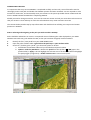
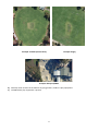
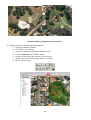
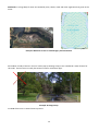
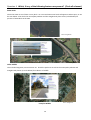
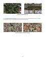
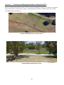
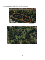
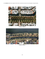
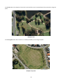
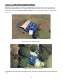
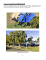
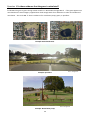
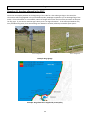
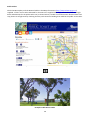
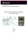
Faculty of Medicine, Dentistry and Health Sciences
School of Population Health
Centre for the Built Environment and Health
Public Open Space Desktop Audit Tool (POSDAT)
Part 2: Auditor’s Manual
Prepared by
Nicole Edwards
Paula Hooper
July 2012
1
The information presented in this user manual has been adapted from Broomhall et al.’s (2004) POST
manual (Broomhall et al., 2004) and was written by Nicole Edwards and Paula Hooper. All
orthoimages of the Perth metropolitan (dated/flown in 2010) in this document were supplied by
Landgate (Western Australian Land Information Authority, 2010). Streetsmart maps are a digital
version of the Perth Street Directory and are supplied by Landgate (Western Australian Land
Information Authority, 2009). Google Street View (Google Inc., 2011) images have been referenced
individually throughout the document. References appear in full at the end of this document.
Citation
Edwards N, Hooper P. POSDAT Training Manual. Perth: Centre for the Built Environment and
Health; 2011. Available from: http://www.sph.uwa.edu.au/research/cbeh/projects/postdat
For further details please contact:
Nicole Edwards
Centre for the Built Environment and Health
School of Population Health
The University of Western Australia
35 Stirling Highway, Crawley, WA 6009
Tel: 6488 1255
Fax: 6488 1199
Email: [email protected]
2
STUDY AIMS
The aim of this study is to collect information related to the quality, facilities, amenities and attractiveness of
parks within the Perth and Peel metropolitan area. This information will be used to inform the RESIDential
Environments (RESIDE) II project, which aims to examine the longer-term health impacts of urban design on
heath status and to translate the research findings into policy and practice.
Approximately 5000 parks need to be audited during the University’s vacation period (June 27th – July 31, 5
weeks total). As a rough guide, small parks should take 8 minutes, medium parks 12 minutes and larger parks
up to 18 minutes to audit. For quality control purposes, parks will be randomly selected to be audited more
than once so that inter-rater reliability can be assessed. Your attention to detail on every park audit is critical.
GENERAL INSTRUCTIONS
The purpose of this manual is to guide you through the auditing process using the Public Open Space Desktop
Auditing Tool (POSDAT) (Edwards et al., 2011) . You MUST ensure that you have read and understand the
information contained in this manual before commencing any audits.
PREPARING FOR AUDITING
It is important that you are familiar with POSDAT prior to auditing. We will provide a two day training
workshop, but you should also practice using the form before you begin auditing. This will ensure that you
know the order and content of all questions on the form.
To conduct the audits, you will need the following items:
•
•
•
•
Desktop Auditing PACK containing:
- List of park identity numbers for the Local Government Area (LGA) you have been assigned
- Pre-printed facilities/amenities information obtained from your allocated LGA’s website
- Sufficient Desktop Auditing Tool forms to complete all audits for that LGA
Computer workstation with access to ArcMap and Google Earth
This manual
Blue biros
3
PREPARING THE DESKTOP AND GIS WORKSPACE FOR AUDITING:
1.
2.
3.
4.
5.
6.
7.
8.
Open a new ArcMap project
Add the 2010 orthophotography
Add Streetsmart map
Add the relevant LGA Formal Open Space POS shapefile
Add the suburb layer
Add your [LGAname_PLAYGRD_AuditorName] shapefile
Turn the GIS editor on:
a. Ensure the Editor extension is turned on: right click on the top bar > scroll down > Editor
b. Click Editor (the Editor Toolbar will appear)
c. Click Editor on the Editor toolbar > Start Editing
d. Select the folder / shapefile you want to edit (i.e. your point playgrounds shapefile)
Open Google Earth
4
CONDUCTING THE AUDIT
It is important that every item on POSDAT is completed carefully and correctly. You will therefore need to
thoroughly assess each park and double check EVERY question has been answered. You are required to circle
answers for most items, and occasionally write your answers in the spaces provided. Please use BLUE ink and
write in CLEAR CAPITAL LETTERS when completing POSDAT.
Should you need to change an answer, cross out the incorrect answer and tick your new choice. Please ensure
that your answer is clear and easy to read. This will make data entry easier and more accurate.
The sections below provide step-by-step information and checklists that will help you interpret and answer
questions in POSDAT.
STEP 1: Selecting and navigating to the park you wish to audit in ArcMap
Parks should be audited one at a time in a sequential manner following the order displayed on your PARK
IDENTITY LIST until every park within the LGA, or that you have been assigned, has been audited.
1.
2.
3.
Identify the first / next posid from your PARK IDENTITY LIST
Open the parks attribute table: right click on the park layer > open attribute table
Search for / find the given “posid” (you have two options to do this:
a. Scroll down the attribute table until you find the desired posid number
b. Options > Select by Attributes > double click posid from the top box > = > ### (type in the
posid number) > Apply > this will highlight the relevant row in the attribute table and highlight
the park polygon (in light blue) > double click this row to zoom into the park.
5
Note: If the park you are auditing is labeled ‘local pocket park’ in the GIS attribute
table then use the Mini POST provided. This is a shorter version of POST and is
marked MINI POST.
STEP 2: Complete the “Preliminary Information” section of the POSDAT
The top of the Desktop Auditing Tool requires you to record the following details related to each park. Note: a
separate Desktop Auditing Tool is required to be completed for each park. Remember to use a blue pen and
clear writing.
i.
Auditor name
Your full name is required
ii.
Date of audit
Date of commencing park audit
iii.
Uid (unique id)
Record the “uid” from the attribute table where required
iv.
LGA
Local Government Area the park is situated within (this information is on your PARKS IDENTITY LIST)
v.
Suburb
Turn on the Suburb Extent layer and record the suburb name in which the park polygon falls. If the
park extends across two or more suburb boundaries write ALL the suburbs it falls into down.
vi.
Park name
Turn on the StreetSmart layer.
Where a park name can be identified from the Streetsmart layer record this in the “park name” field
Note: many smaller parks do not have a name. If a name cannot be determined from the Streetsmart
layer then tick the “no name” box on the Desktop Auditing Tool.
vii.
Road Name 1
This refers to the name of a road/s surrounding the park. This will help you locate the park in Google
Earth if there is no park name.
Using the Streetsmart layer record the name of one road on which the park is located.
6
viii.
Road Name 2
This refers to the name of a road/s surrounding the park. This will help you locate the park in Google
Earth if there is no park name.
Using the Streetsmart layer record the name of one road on which the park is located.
.
e.g.
Road Name 1 = Beaumont PWY
Road Name 2 =
Road Name 1 = Candella Square
Road Name 2 =Varese Road
STEP 3: Record park features identified from the LGA’s website onto POSDAT
Review the pre-printed facilities/amenities information obtained from your allocated LGA’s website that relate
to the specific park you are auditing. Complete as much of the POSDAT as possible. Information commonly
supplied by LGA’s via their website include information from sections; Activities, Dogs and Amenities of the
tool.
STEP 4: In ArcMap - Turn of Streetsmart and Turn on the 2010 Orthophotography
STEP 5: Locate the park in Google Earth
First make sure you are familiar with the Google Earth program (APPENDIX D)
In Google Earth: Locate / identify the same park in Google Earth. This may be done by searching the park
name and/or the surrounding street/s name/s identified from Streetsmart
IMPORTANT: Make sure you are auditing the correct park (in the correct state and suburb) and use the aerial
image of the park boundary in the GIS layer as a visual cue (i.e. audit all of the area within the green boundary
line).
Proceed with the rest of the POSTDAT audit.
Work through POSDAT from the beginning, entering the details onto hard copy of POSDAT
7
Activities
Question 1 What type of activities is the space designed for?
a) Carefully check all areas of the POS for areas that have been specifically designed for sports. This includes
playing fields, courts, informal courts with markings or basketball rings, goal posts. Please note that
walking and cycling are covered in Question 15 (a).
b) Circle Yes for the relevant sports on the list.
c) Tick ‘Other’ if the type of activity is not included in the list. Please write in the space provided what this
activity is.
The following pictures provide a rough guide to the field markings for sports commonly played on ovals and
playing fields. These will help you determine the type of sport.
Example: Baseball
Example: Soccer
Example: Cricket
Example: Hockey
8
Example: Football (Aussie Rules)
Example: Rugby
Example: Skatepark/BMX
d) Carefully check all areas of the POS for any playgrounds / children’s play equipment.
e) Tick Yes where play equipment is present
9
Example: Children’s Playground / play equipment
f)
Digitise the location of the playground equipment
a. Navigate to the Editor Toolbar
b. Click “Editor > Start editing”
c. Select your playground equipment shapefile to edit
d. Click the Sketch Tool on the Editor toolbar
e. Navigate to the playground and insert a point feature
f. Navigate back to the Editor toolbar: Editor > save edits
g. Editor >Turn off editor
10
Environmental Quality
Question 2 Is the POS on the beach/river foreshore?
If the boundary of the park adjoins the river or beach, then circle Yes. If there is a road, railway line, or any
other barrier between the POS and the river/beach foreshore, then circle No.
Source: GoogleEarth
Example: Yes
Example: Yes
Example: No
Question 3 Is there a water feature present? (Circle all relevant)
A Lake is a body of water (salt or fresh water) of considerable size, surrounded by land. A pond is a smaller,
artificial water feature. Circle Lake/pond if the POS contains either a lake or a pond.
Source: GoogleEarth
Example: Lake
Example: Pond
11
A Water Fountain is a jet or stream of water made by mechanical means
Example: Water Fountain
A Stream is a body of flowing water
Example: Stream
12
Wetlands are a large body of water surrounded by trees, shrubs, reeds and other vegetation that grows in the
water.
Source: GoogleEarth
Example: Wetlands as seen on orthoimagery and Streetsmart
Please Note: A body of water in front of a drain pipe (a drainage sump) is not considered a water feature for
this audit. These areas are usually fenced and contain a visible drain pipe.
Example: Drainage Sump
Circle No if there are no water features present.
13
Question 4 Which, if any, of the following features are present? (Circle all relevant)
Water birds
Check the water to see if there are any birds. At a 4m resolution water birds will appear as white specs, as can
be seen below. Also check the municipality website and the Google Earth photo icons (circled below) for
pictures of waterbirds at the POS.
Source: GoogleEarth
Source: GoogleEarth
Other wildlife
This includes kangaroos, emus tortoises etc. Check the park area as well as the municipality website and
Google Earth photos (as circle below) for evidence of wildlife.
Source: GoogleEarth
Example: Wildlife
14
Gardens
A garden is any space with numerous plants (flowers, shrubs or trees) planted in a garden bed and defined
with a border.
Example:Gardens
Circle No features if there is no feature present in the POS.
15
Question 5 Estimate the approximate number of trees present (Tick one only)
If there are no trees present, cirlce No trees.
Estimate (by counting tree canopies) the number of trees present in the POS. Include in your estimation trees
that are on the perimeter of the POS or along walking paths in the POS.
Question 6 Where are the trees placed? (Circle all relevant)
Cirlce Perimeter all sides when the trees are located along all sides of the POS.
Example: Perimeter all sides
Circle Perimeter some sides when trees are placed ina row along at least one side, but not all sides.
Example: Perimeter some sides
Circle Along walking paths when trees are placed in a row along walking paths through or around the perimetr
of the POS.
16
Example: Along Walking paths
Circle Random placement throughout when the placement of trees in the POS appears ‘natural’, or without
any apparent pattern, or with a pattern but spread throughout the POS.
Example: Random placement throughout
17
Question 7 (a) Are there walking paths within or around the POS?
Paths are cleared tracks with hard surfaces that can be used for walking or cycling. The surface of a path may
vary to include stone, concrete, dirt or gravel. If walking paths are present, circle Yes. If there are no paths
circle None and go to Question 9.
Example: Walking path with concrete surface
Example: Walking path with dirt surface
18
Source: GoogleEarth
(b) Shade along paths (Circle one only)
Circle Very good when the canopies of many trees touch along the paths.
Source: GoogleEarth
Circle Good when the canopies of some trees touch along the paths.
Source: GoogleEarth
19
Circle Medium when the canopies of trees don’t touch but the trees are close together along the paths.
Example: Medium
Example: Medium
20
Circle Poor when the canopies of trees don’t touch and the trees are spread apart from each other along the
paths.
Example: Poor
Circle Very poor when there is little or no shade provided by trees along the paths.
Source: GoogleEarth
Example: Very Poor
21
Question 8 Is the children’s playground shaded?
Shade refers to a man-made cover, it does not include nearby or surrounding trees. If it is not clear that a
playground is beneath shade cover, try using the Google Street View to see if you can view the playground
from another angle. Circle Partial man made covershade if all or part of the play equipment is visible without
any shade.
Source: GoogleEarth
Example: Total man-made covershade
Example: Partial man-made covershade
Circle Yes if the park has more than one playground and at least one of the playgrounds has a man-made cover
shade..
22
Question 9 Is the children’s playground fenced?
This question is to determine if dogs are physically unable to access the children’s playground due to fencing.
It does not include balustrades that may deter dogs accessing an area of the POS. If there is more than one
playground in the POS and at least one of the playgrounds is fenced, circle Yes.
Source: GoogleEarth
Example: Fenced playgrounds
23
Question 10 Is there evidence that the grass is reticulated?
Circle Yes if the grass is green during warmer months i.e. November through March. If the grass appears non
reticulated on the aerial imagery supplied then check Google Earth for a difference in colour and evidence of
reticulation. Also circle Yes if there is evidence of a reticulation pump, pipes, or sprinklers.
Example: Reticulated Grass
Source: GoogleEarth
Example: Sprinklers
Source: GoogleEarth
Example: Reticulation pump
24
Dogs
Question 11 Are dogs allowed in the POS?
Check the municipality website at the beginning of the audit for rules relating to dogs in the POS (This
information will be highlighted in the printed Municipality webpages supplied to you at the beginning of the
audit). If this information is not available, switch to Google Street View and check the perimeter of the park
for dog signs. If you cannot read the signs clearly circle ‘no dog information’. If the municipal website only
lists prohibited dog areas, then assume dogs are allowed in all other publically accessible open spaces.
Source: GoogleEarth
Source: GoogleEarth
Example: Dog signage
Example: Dog information supplied by municipality
25
Amenities
Question 12 Amenities present (Tick all relevant)
Some of these items may be listed on the municipality website. To search for features that have not been
listed use the zoom button to check the entire park for the listed amenities. If a feature is present that could
be one of the amenities but is not easily identifiable, an internet search (using the park name if known) may be
used to verify the particular feature. Please double check any image used for this purpose is from the same
park you are auditing. Please always seek advice from the supervisor when using this method.
Barbeque Facilities
Check to see if there are gas, electric or wood barbeques within the POS. Particularly check around areas with
seating. Barbeques can be seen more clearly at 4m resolution or using Google Earth Street View.
Source: GoogleEarth
Example: Barbeque facilities (4m resolution)
Source: GoogleEarth
Example: Barbeque as seen in Google Street View
26
Seating
The question refers to seating only within the boundaries of the park. Do not include seating that is with
picnic tables.
Example: Seating (2m resolution)
Picnic Table
Picnic tables must include a table and cannot be seating alone. Check around barbeque areas.
Source: GoogleEarth
Example: Google Earth Street View (picnic table and BBQ)
27
Kiosk/café
Check to see if there is a permanent structure (building) within the POS that sells food. Do not include kiosks
or cafes on the streets around the POS. Do not include ‘Mr Whippy’ vans or mobile food outlets. Do not
include kiosks associated with local clubrooms that are only open for local weekend sporting matches. Watch
for Google Earth icons (as seen below) that indicate a coffee shop or café present.
Example: Kiosk/Café icons
Source: GoogleEarth
Example: Google Earth icon (circled) showing café/restaurant
28
Public Toilets
Check the Municipality and The National Public Toliet Map information (http://www.toiletmap.gov.au)
supplied. If there are no toilets indicated for the POS in the supplied hard copy information, look on Google
Earth and Nearmap for the public toilet icon (as shown below). Double check information obtained from hard
copy sheets or Google Earth by checking that the park contains a building that could be the public access toilet.
Example: Public toilet icons as seen on National Public Toilet Map
Source: GoogleEarth
Example: Public Access Toilet
29
Public art
For example, murals (e.g. graffiti murals), sculptures and other ornamental features (e.g. clock tower, sun dial).
Use aerial imagery and look for photo icons on Google Earth to identify public art. Also check the border of
the POS using Google Earth Street View to check for public art.
Example: Public Art
30
Car parking facilities
Take care to check all sides of the POS. Circle Yes if there are marked parking bays within or adjacent
to/alongside the park (or clearly identified as serving the POS. Do not include POS verges as parking facilities.
If there are no parking bays serving the POS, circle No.
Example: Marked parking bays
Example: Formal carparks adjacent to park
31
Safety
Question 13 Where is the lighting located? (Circle all relevant)
This question relates to lighting specific to the POS. It does not include normal street lighting.
Circle Around courts, buidlings and equipment if lighting is located next to these features.
Circle, Along paths if lighting is places in a row along paths through or around the perimeter of the POS.
Circle Perimeter all sides if lighting is located along all sides of the POS.
Circle Perimeter some sides when lighting is places in a row along at least one side, but not all sides of the
POS.
Circle Random throughout POS when the placement of lighting in the POS appears without any apparent
pattern, or with a pattern but spread throughout the POS.
Example: Lighting around courts, buildings and equipment and along paths
32
References
Broomhall, M., Giles-Corti, B., A., L., 2004. Quality of Public Open Space Tool (POST). The University of Western
Australia,, Perth, Western Australia.
Edwards, N., Hooper, P., Giles-Corti, B., 2011. Public Open Space Desktop Auditing Tool: POSDAT. University of
Western Australia.
Google Inc., 2011. Google Earth, Mountain View, CA.
Western Australian Land Information Authority, 2009. StreetSmart (Digital image Edition), Midland, Western
Australia.
Western Australian Land Information Authority, 2010. Aerial orthophotography, Midland, Western Australia.
33