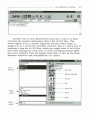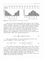
1
The lntemational Center for Tropical Agliculture (CIAT. its Spanlsh acronym) ls one of
16 food and envtronmenlal research organlzatlons lmown as the F\tture Hruvest centers.
The cenlers. located around the world. conduct research In partnersWp wtth farmers.
sclenUsts. and pollcymakers to help allevtate poverty and lncrease food secwity whlle
protectlng the natural resource base. The Future Harvest centers are prlnclpally funded
through the 58 countrles. prlvate foundatlons, and regional and international
organlzations lhat make up the Consultative Group on lntemational Agrlcultural
Research (CGIAR).
In 200 !, CIAT received support from the followtng donor countr1es: Australia.
Belgium, Brazil, Canada. Colombia, Denmark, France, Germany. lran, ltaly. Japan.
Mexlco . thc Netherlands, New Zealand. Norway, Peru. Soulh Afrtca. Spain: Sweden.
Swttzerland, Thailand, lhe Unlted Kingdom. and lhe United States of Amertca.
Our work was also financed by the foUowing organJzaUons and foundaUons:
the Asian Development Bank (ADB) . the European Unlon (EU) . lhe Unlted NaUons
Food and Agrlculture Organtzation (FAO). the Ford FoundaUon. Fundación Polar.
the lntemaUonal F\tnd for Agricultura! Development (IFAD). the Kellogg Foundatlon.
the Nippon FoundaUon. the Rockefeller Foundallon. the Wallace Foundatlon. and
the World Bank.
CIAT aJso recelves funds for research and development servlces provlded under
contract lo a growtng number of institutlonal cUents.
lnformaUon and concluslons reported In th!s document do not necessartly reflect
lhe posltlon of any donor agency.
ISBN 958-694-046-2
MarkSim@
A Computer Tool That Generales Simulated
Weather Data for Crop Modeling and Risk Assessment
Version 1
2002
R G. Jones, R K. Thornton, W. Díaz, and
1\ W. Wilkens
Edited by Annie L. Jones
Manual Copyri¡Qlt 9 1998-2002
Softwart' Copyright C 1978-2002
MarkSim ts '~Tillen uslng MapObjccts LT and Delplú. MapObjec-ts
LT is a trademar k of the Environmental syst ems R¡,search
lnsUtute. lnc. Copyright 1999. Em'ironmental Systems Research
lnsUtutc. lue. All Righ'-" Rescrved. DelpiU is a trademark ofBorland
lntemaUonal. lnc. Copyright 1983. 1999 lnptise Corporation.
Centro lntem aC'ional de Agricultura Tropical
lnlemational Ccnter.for TI'opical Agriculture
Apartado Aéreo 67 1:1
Call . Colombia
Fax:
+57 (21 4450000
E-mail: [email protected]
CIAT Publkalion No. 330
ISBN 958-694-047-0 (CO-Im M)
ISBN 958-694-046-2 (manual)
f>res.s ru n: 500
f>rlnted in Colombia
September 2002
Jones. Peter G.
MarkStm : a computcr too! that generales simulaled weather data for
crop modeling and tisk asscssment : \·ersion 1 1 P.C. Jones. P.K. Thomton.
W. Diaz. and P.W. Wilkens : edlted by Annle L. J on,.,. -- Cal!. CO :
Centro Internacional de Agricultura Tropical, 2002.
1 CD-ROM + Manual : MarkSim : a computer lool U1a1 generales stmulated
wealher ddta for C'rop modcling and risk assessment : Vt.>rston l.
(87 p.) -- (CD-ROM series)
ISBN 958 694 047-0 (CD-ROM)
ISBN 958-694 -046-2 (manual)
AGROVOC desc-riptors in Spanish:
1. Tie mpo meteorológic-o. 2 . Modelos de s imulac-ión. 3 . Bases de datos.
4. Condtdones atmosféricas. 5. Clima.
AGROVOC dcst·•i ptors in English:
1. WcaU1er. 2 . Stmulalion models. 3. Dalabase,. 4. Meteorolo¡.(ical
elernents. 5. Cllmatc.
l. llUe. 11. Thomton. Phlllp K. 111. Díaz. Willlam. IV. Wilkens. Paul W.
V. Jones. Anrúe L. VI. Centro Internacional de Agrtrultura Trop•cal. VIl . Ser.
AGRIS subjcct catel.(ones: P40 Meleorology and dlmatulogy
U 10 MaU1emat:Jcal and staUsUcal meU1ods
LC dassíficaUon: S 600 .4 J66
Copyii¡Qlt CIAT 2002. All tights rt'served
CIAT encourages wtde dissemina llon of its prinled a nd electronlc publlcallons for maximum
publlc bcncnt. Thus. In most cases colleagues worklng In rt>search and developmcnt should
fecl free to use CIAT matctials for noncommerclal purposcs. l lowevcr. thc Ccnter prohlbíts
modtflcaUon of thcse malerials. and we expcct lo rec-elve duc crrdlt. Thou¡Ql CIAT prepares lts
publlcatlons wlth considerable C'are. the Centl'r doC"s not guara n tcc th clr accuracy and
completcness.
Contents
Page
Introduction
Getting Started
3
l. ThtoiiaJ
5
Giid lndependent Climate Data
5
Giid Dependent Data
1O
Running the Simulation
15
2. User Reference Section
20
OveiView of MarkSim Operation
20
The Map Window
20
The Main Menu Service Icon s
22
3. Theory
44
The Rainfall Model
44
Interpolating Back to Daily Data
48
Annual Valiance and the Vartability of Parameters
48
Simulating Temperatures and Solar Radiation
50
The Climate Surfaces
51
References
62
Appendix A
MarkSim FiJe Structures
Appendix B
Functions for Correcting the Censored Gamma Distlibution
Index.
65
65
74
74
80
Introduction
Mark.Sim has a long history. The rotation algorithm was written on
the 6th of March 1978, not long after I had joined CIAT and started
constructlon of the CIAT Climate Database. Markov models of
rainfall have been used in many areas. A survey of the Uterature
that 1 made in the rnid 1980s carne up with more than a hundred
references. However, they have never been particularly successful in
the troplcs. 1 wondered why and eventually carne to the conclusion
that the weather systems prevalent in the tropics do not include the
frontal weather with travelling highs and lows that you find at
temperate latitudes. This means that the weather generatlng forces
are completely different and need a different arder of model to fit
them. 1 eventually showed that this requtres at least a third arder
model, where a first or second arder would produce a good fit in
temperate climes.
1 pursued these tnvestigations as a minar part of my studies in
CIAT. One couJd almost say it was a hobby- until Phil Thomton
noticed what 1 was doing in the early 1990s. He saw lts application
to crop modeling and pushed me to pubUshing the first paper.
Jones and Thomton (1993). We have been strong collaborators ever
since, producing a series of papers and working to craft MarkSim as
a part of the CIAT Climate Database tools.
The MarkSim beta release, written for DOS operating systems.
went to over 20 sclentists in 1998. The response was good; indeed.
Jeff White of the Intemational Maize and Wheat lmprovement
Center (CIMMYI1 used lt to produce a rainfall reliabllity map for the
whole of Africa. It has taken a disappointlng number of years to go
from there to thls release for Windows. A lot of work has gone on In
the meantime. The basic model has been revlsed. The database to
which it is fitted has grown and been substantially cleaned. The
station algorithm has been rewrltten to lncorporate dlfficuJt climates
where rotation on rainfall pattem is not valid. We have incorporated
new batch processtng options that wlli greatly facilitate lts use with
geographlc lnformatlon systems (GIS).
1 am writlng thls tntroductlon, but MarkSim would not have
happened without Phll Thomton. It has been done with remarkably
2
MarkSim
little outslde funding. John Lynarn of the Rockefeller Foundation
has given us a couple of small. but incredibly useful, grants. We
would Uke to thank Paul Wilkens of the IntemationaJ Fertilizer
Development Center (IFDC) for his prograrnming in Delphi of the
flrst version of the Windows interfacer. (Paul. you will recognize
sorne parts of it.) William Díaz, as my system anaJyst and
programmer. has bom the brunt of my quixotic decisions on the
look and fcel of the software for over a year now.
This version works. 1 am sure thal the next will be better. but
as it is already 2 years late, this is what you get.
Peter G. Jones
Getting Started
MarkSim is a Windows application that will be ins talled from the
CD-ROM and registered a utomatically. The program files will
normally be installed in the directory C:\Program Files\ClAT\, and
unless you have a good reason for installing in another directory we
strongly recommend that you Jet the install package go ahead and
do so .
./
Insert the CD-ROM in yoLrr CD drive .
./
Go to the run prompt and type X:\setup where X is the drive
letter of your CD clrive.
The MarkSim system comes with Iarge data files. The first
window of the install procedLrre shows an analysis of the disk s pace
available on yoLrr system and subsequent windows will allow you to
tailor !he installation to make best use of this space .
./
Note where best to instan MarkSirn.
./
Hit Yes lo proceed .
./
Read the notes on !he following screens .
./
Then choose the relevant inst.allation type.
The Iargest set of data files is the map coverages. These are
Environmental Systems Research lns titute (ESRJ) sha pefiles that
are used to create the backgrounds for the. ma ps you will u se with
MarkSim. The directory is called \coverages\ and is 582 Mb. You
can elect to leave il on the CD-ROM if you are s hort of disk space. In
this case choose the option 'Typical' when the lns tall shield requests
it. Leaving it on !he CD-ROM will nol slow MarkSim operations lo
any greal extenl, but it does mean that you have lo have !he
CD-ROM in the drive whenever you work . tf you choose to install it
on the hard disk, the install shield will attempt lo pul il in a
directory \ MarkSimFiles\ on a disk with sufficient space. You may
override this and choose another site for it if you wish.
4
MarkSim
The climatc grid mes and all lhe model parameters are stored
in the directory \ markda t\: this is currently 336 Mb. lt has to be
installed on a disk and wUI be flagged read only. We s uggest that
you Insta]] it, if possible, a way from the program flles on your C
disk. The install shield will altempt lo pul it in the dircctory
\ MarkSimFiles\ as above.
The last choice you have is where to put the working
direclories \ dat\ and \ou tput\. These will cont.aJn your input and
output illes. It is also best to keep these away from the program files
directory. MarkSim output can be voluminous so make s ure that
wherever you decide lo pul Lhem thcre is sufficient disk space .
./
Hit Finish to start the installation.
l.
Tutorlal
1bis tutorial glves a quick introductlon to sorne of the common
operatlons you may be doing With MarkSim. The software is
destgned to produce simulated daily weather data for any point in
the tropics. It runs off interpolated cllmate surfaces and operates in
two parts. The first creates a me (CLX file) of model parameters. The
second runs the MarkSim simulation to produ ce the daily weather
data files. For details of the operatlons see User Reference Sectlon
(p. 20). For how the model works see Theory (p. 44).
MarkSim uses three main subdirectortes, two for wor:king files
and one for map coverages.
MarkSim offers you two types of input. If you know the
monthly average climate data for the point you Wish to simulate,
you can enter them. This type of input restrtcts you to points With
actual climate data, but it operates fully independently of the
interpolated climate grtds so lt will work for anywhere in the world.
The second type of input is where you do not have climate data. but
know the whereabouts of the point you Wish to model. This works
from the cllmate grtds and will simulate any point in the tropics
provided that it is on a c11mate grtd. This method is somewhat
restricted at present; it works for Latln Amertca, Afiica, and South
East Asia, including Asia and southem China below 342 N.
Grid Independent Climate Data
This form of input depends on the .DAT me to input data to
MarkSim. A .DAT me looks like this:
mex07160
42 . 4 3.
17 . 130 -92.720
23.
70
4 7. 115. 264 .
471
471
188. 236.
471
275 . H2.
86.
56.
18.0
18.2 20.8 22.4 22 . 8 22.1
21.7 21.5 21.1 20.8 19.5 17.9
10.4
11 . 1 13 . 0 13.3 12.9 11 . 7
11. 6 11 . 6 10.5
9 . 6 10 . 1
9.9
See Appendix Afora full description of the format. You can
produce this ftxed format ASCII file in a number of ways. If you have
6
Mark:Sim
data labulated and wish to wrtte out a series of DAT files. the
F'ORTRAN formal for the file is:
(a8.2f8.3.i6./ 12f5.0./ 12f5.1./ 12f5.1)
Running single DAT files
If yo u have only a few files to prepare, you may type them in directly
in an ASC!l editor. or use the MarkSim editor. F'or grtd independent
data entry. you do not need to load a map. aJthough if you have one
displayed by default. there is no harm in leaving it there.
~\'\ l ./
~
Selecllhe spatial input too! to bring up lhe spatial
mput wmdow.
If you wish lo enter data as a single DAT me. select the DAT
option in the t.h.ird panel. If the DAT file exists. you can browse for it
in the DAT directory. We have placed palmira.dat there for you to try .
./
Browse for palmira.dat.
./
Open il.
./
Create the fUe palmira.clx by click.ing on Run Ma rkSim in the
lower left comer of the window.
If there were no errors, MarkSim will tell you so and ask if you
would like to see the Jog file. This is a fiJe to record the process of
the nms. Jf you want the full irúormation on the run. choose full on
the panel clxgen .log. Selecting errors will give you a minimaJ output
with only the error messages. It is best to change to this option once
you are processing Iarge quantities of data.
Now to practice entering the data with the MarkSim editor.
./
Select the DAT panel.
This editor icon will light up on the rtght of the panel.
,- ,
~-=-.9............•
ThJDrial
./
7
Type in the data from the Mexícan station given in the example
above. Type -500 for the January rainfall and t.ry lo save the
file.
We have included sorne rudimentary data checks to trap
errors. If you want lo check your typing as you progress. use the
cloud question mark icon to do a running check on the file .
./
Correct the January rainfall, save the file. and run the job.
./
Check with the log and have a look at the CLX file.
You will find a detailed description of the file contents in
Appendix A
~
When viewing a .file. you are offered. the option of ed.iting it
or viewing the data as graphics. You may ed.it a CLX.file,
but we highly recommend that you do not do so. The
parameters are interUnked. and ed.i1ing one without
a4,justing the set may resul.t in serious errors.
You can also use the DAT editor to correcl files .
./
Enter the editor.
./
Select open a file .
./
Browse to find the Mexican file you have just made .
./
Open it and change the data.
./
Ch,ange the site name and save it as another file.
In this way you can use the base data in one file as a template
for another. Only make sure that you have changed all the data
necessary to completely define the new file.
8
MarkSim
Running multiple DAT files
lt often happens that you will want to simulate a lot of points at a
time. Using MarkSim along With a GIS is a good way of testing
model results over a study area. It ís also a good way to be left
handling very large quantities of data. For this reason. we have
included a number of batch processing options. The Cümate Batch
File (CBF) is one example.
The CBF is a sequential ASCll tlle conl.alning. in each record.
the FULL path to a DAT tlle. It looks Uke thís:
C : \Program Files\CIAT\MarkSim\dat\K9238003 . dat
C : \Program Files\CIAT\MarkSim\dat\Mex07160 . dat
C : \Program Files\CIAT\MarkSim\dat\Hendersn . dat
CBF File Selection (Ciimate Batch Fde)
r.
t
fg:: Browse
Selcct
Yiew
panel
file
Drag and
drop
You can construct a CBF in many ways. You can type it in to
an ASCII editor. construct it from the DOS DIR instruction, or you
can use the handy drag and drop facility provided in MarkSim .
./
Select the CBF panel on the spatial input window .
./
Click on the drag and drop icon at the rtght of the panel.
You wíll see the DAT fi.les available in the DAT directory
dísplayed in the top left window. You can search for DAT files in
other directortes or on other drtves by altering the path and drive in
the lower windows. To select a single DAT ftle:
./
Highlight ít by clícking on the filename .
./
Use the pass selected button to transfer it lo the file building
list in the right hand window under selected files.
Tulorial
9
To select all DAT files in lhe directory use lhe pass all bulton.
You can change dlrectory to add more DAT files from elsewhere in
your system.
l!lliJEf
~1! 1 \I'HIILHAN f 111 S\t lA 1\WAR< SIN \011 1 \MI Xnf iGO 0111
Pass selected
tawd•
C8FH•1CU
Save the CBF and exit.
.1
Browse and select the created CBF with the browse function .
.1
Open it, and check it with the view ille butlon.
When you now run !t. MarkSim will create three CLX files in
the output dlrectory.
10
MarkSim
Grid Dependent Data
This is lhe main purpose of MarkSim. From the interpolated grids
you can produce a simulated daily output for most points in the
tropical world.
Setting up the map
The coverages directory contains ESRI shapeflles of map
background irúormation lhat you can use to display a map to
navigate the cllmate grids. We will start by making a map to use
with the Latin America cllmate grid. The background !ayer
sarncountries will be loaded automatically in lhe newly installed
version of MarkSim. You can change this default with the
configuration too!. but for the present lets leave lt as default.
./
Select the !ayer control tool to display lhe !ayer control window .
./
Use lhe zoom in tool to zoom into a \vindow in westem
Colombia.
We are going to add
layers unW you can see
a detailed map that you
can navigate to find the
relevant pixel for CIAT,
which ls situated 23 km
northeast of Call on the
road to Palmira. We will
zoom in as we go
because the layers we
are going to add will
cover the continent with
a cluttcr of irúormation.
layer Propoerhes Tool
Load !ayer
- - - - - - - - - - -- - -- - - - - - - - - Tutorial
./
Zoom in again as at
rtght.
./
Select the load layer icon
in the layer properties
too l.
11
You will be shown the
layers available in the
coverages directory .
./
Select samroads.shp
and change the color to red .
./
Zoom to the window shown on the right. then select the
coverages sarnrivers. and change the color to blue .
./
Select samtowns; use set layer properties to set on the name in
the labels fields.
Now we can see
where we are. ClAT lies
in the Valle del Cauca,
or valley of the rtver
Cauca. between two
large Andean
mountain ranges-the
Cordillera Central to
the east and the
Cordillera Occidental
to the west, also called
the Farallones or cHffs
of Cali .
./
Make sure you have the zoom in tool selected and place the
cursor over the place symbol for Cali. which appears direcUy
below the "A" in the ctty name .
./
Lefl click.
12
MarkSim
The map will redraw and a small blue dot will appear where
the cursor was placed .
./
Track the cursor along the road to Palmira (the Recta in local
parlance) until the distance (at the lower left of the map
window) registers 23 Jan.
You have now arrtved
at the fronl gates of CIAT
and the coordinates in
latitude and longitude
appear al the lower right of
the window. You are nearly
ready to construct the CLX
file for the location.
However, the climate grid
you are working from has
pixels of lO are minutes on the side (about 18 km at this Jatitude).
The valley at tlús point is only about 30 Jan wide (check this with
the MarkSim measuring tool just like you measured the distance
down the Recta from Cali). There is therefore one last check to
make .
./
Go to the layer control tool and select america_grld from the
shapefiles.
This conlains the pixel boundaries of the climate grid. You will
have to go to the layer properties tool to set the fill to transparent
because it is a polygon shapefile and you will need to see the map
lhrough it.
The grid pixel boundaries show that CIAT is almost exactly on
a pixel boundary. The eastem pixel includes sorne of the foothills of
the Cordillera Central, whereas the westem pixel is almost all valley
floor.
Check on the clirnate data to which you will be
fitting.
Climate
diagram
tool
Select the climate diagram tool and click on the
westem pixel.
Now click on the eastem pixel.
-
- - --
- - -- --
- - --
- - - - - - - - nttortal
13
Olte first climate diagram will disappear behind the map
window. You will have to shift the map window to pick it up. I am
sony ~bout thls: it is a glitch that we have not been able to fix as
yet.) You will notice that there is very litUe difference. This is
because the NatlonaJ Oceanographic and Atmospheric
Adminlstration (NOAA) digitaJ elevation model (DEM) to which the
climate grid ls fltted holds the modal elevation, not the average. so it
is approximating well to the valley floor. The small dillerence you
will notlce ls that the valley floor (western) pixel ls s lighUy drier.
This is actually masking a larger effect that we would expect in
this valley. The Valle del Cauca is a large tropical valley and exhibits
the typlcal large tropical valley circulatlon where there ls a
predominance of descending air in the valley center because of
differential solar heating at the sides. This results in a rainfaJI
gradient that ls wetter at the sides and drier in the middle.
MarkSlm will shortly be linked to high precision (1 km or 20 are
second) grids, but we have to fix sorne problems of data storage and
access before this can be implemented .
./
Choose which pixel you want and select the select a
latitude, longitude point tool, point at the relevant
pixel. and left click.
The spatial input window will appear with the
coordinates and elevation of the pixel filled in for you.
./
Type in a name for the CLX file .
./
Choose full reporting in the clxgen.log panel.
./
Hit the run clxgen button.
Selecta
latitude,
longitude
point tool
You should see a message saying no errors were encountered
and asking you if you would like to see the log .
./
Say yes and check what MarkSim has done for you.
When you are more confldent about what is happcning. you
can change the reporting option to errors only to save creating a
Iarge Iog file.
14
MarkSim
Multiple georeferenced point data
Jf you are a power user, perhaps running wlth a GIS
system to simulate points sampled over an area or
along a transect. you will want a batch running system
where a1J you do is speci.fy the latitude, longltude,
perhaps the elevation. and a name for the potnt. The
Georeference List File (GLF) is designed to do just that.
./
11
~
Select the spatial input tool and go to the GLF panel.
f8:: Browse
~r-~~~~~~~~~
GLF name
View
file
Drag
and
drop
Edit
file
You can prepare the GLF as a comma-delimlted sequential
ASCII file wlth any ASCII editor: use the drag and drop facility or
the MarkSim GLF editor. A GLF could look llke this (spaces are not
significant and misstng elevatlon is recorded as -999):
23 . 602 ,
3 . 460 ,
4 . 340 ,
-32 . 918
3 . 895
- 46 . 948 ,
76 . 525 ,
72 . 316 ,
-68 . 854 ,
77 . 073 ,
853 ,
1523 ,
213 ,
1219 ,
999 ,
ITAPEVT
CAL!
CARIMAGU
CLXFTI,E3
BUENAVEN
The drag and drop facility is of relatively Umlted use here
because it searches for CLX files from which to extract the filename.
Since the object of the exercise is to create CLX files this seems a
roundabout way todo !t. It does. however. have sorne use when you
rnight wish to recreate a set of CLX file or correct location data. This
could possibly be of use if you change from one climate grid to an
updated one and you wish to recreate a set of CLX files wlth the new
data. Note that the latitude and longltude are in decimal degrees .
./
Go to the GLF editor and type in all or part of the GLF shown
above.
--------------------------------------------- ruwnw
15
./
Save it and run it by selecting the GLF panel option .
./
Open the file. and run with the run clxgen button .
./
Check that all the CLX files were created and that the missing
elevation s were filled in from the climate grtd.
If you used the GLF in the example above, you will have
noticed that it tlnishes with an error. If you look in the log, you will
see that almost all of the CLX files were created correctly.
ITAPEVI.CLX. however, was not produced. There ls a warning in the
log, b u t MarkSim carried on to process the rest. lf you look at the
coordinates for ITAPEVI, you will notice that this point actually falls
in the middle of the Atlantic Ocean. Itapevi is actually in the state of
sao PauJo in Brazil. Unfortunately, the validation routine in the GLF
editor can only cope with checking if the latitude and longitude are
possible. It cannot check if they are correcL Someone has left off the
negative sign. That is no problem now that you have found it.
./
Go into the editor. correct it. and run the job again with just
Itapevt because all the others ran correctly.
Running the Simulation
Running a single site
Once you have created your CLX files you need to move
to the rungen phase to run the simuJatlon and produce
your simuJated daily data output files. The generate data
tool will take yo u there. or if you are in the climate input
window merely switch to the second page.
The top panel will
allow you to run a
simulation from a single
CLX file.
./
Use the browse key
to find one of the
CLX files that you
created in the first
part of the tutorial.
c.
~
a.....r~~~
::.ü<lroAFia
.--------,
1~
_..:._
___,
ClXFiaD•
C\Pio¡J.. Rn\CIATI~S..~\
__
am.t.n..Cimot• D•ect..,
C\Progr""' r..-lOAT\M<ID:
Y••tloG......
11
a~o
iJ A..-.asooc~ lr;;.o;;.__i].,..,
•
lo DSSAT ~5
OW><J Fia Tl'P8
Dt
("
.,.\ou(p,.
Calendal
e
1.::
16
MarkSim
We will choose lo generate DSSAT 3.5 style oulput for use with
a DSSAT crop growth model.
./
Select the CLX flle CARIMAGU.CLX from the output directory .
./
1)rpe in a climale fllename of four characlers or less.
llús wiU be the name of the DSSAT
CLI file lhal will be produced. In this
example it will be called CARI.CU and each
year of the daily data output will be called
CARinnO l.WTG. where nn is the number of years .
RunBmgen
./
Set lhe random number seed to 1243 .
./
Set lhe number of years you require and hit lhe run button .
./
Check lhe log to ensure that everything worked correctly.
You can now select the outpul file to check lhe data. The start
of lhe fiJe CARIO 1Ol .wrG should look like this:
*WEATHER
@ INSI
cari
@DATE
01001
01002
01003
01004
01005
./
:
cari From I nt:erpola;:.ed Sur· taces
LAT
LONG
4 . 340 -72 . 316
SRAD
/./. . 0
27 . 2
/.7 . 2
24 . 7
2'1 . 2
TMAX
33 . 2
38 . 6
38 . 6
37 . 8
3 8 . ·¡
ELEV
213
TAV .ZIJ1P
27 . 7. 11 . 6
TMTN
22 . 4
23 . 1
23 . o
23 . o
24 . 0
RAIN
0.0
0 .0
0 .0
0 .0
REFHT
99 . 0
WNDHT
-99 . 0
0 .0
Go back and change lhe random number seed and rcrun lhe
job.
The file CARIO lO l.WTG will now contain diffcrent slmulated
data. You can. however, exactly duplicate lhe original run by setting
the random number seed back to 1243. lf you leave lhe default
seed. the actual seed used will be shown in the log me. so even if
you did nol specify it you can always repeat a run if you so require.
- - - - - - - - - - -- - - - - -- - - - - - Thtorial
17
Running multiple sites
The last exerclse is to run the simulation for multiple sltes. You
have already prepared a number of CLX files. You can now run
these from a batch facility. This uses XBF or CLX batch file.
Filename
VifNI
file
Drag
and
drop
C : \ CIAT\ MARKSIM \ OUTPUT\ AFRICA . CLX , AFRI , 4003,12,c
C : \ CIAT\ MARKSIM \ OUTPUT\ASIA . CLX,ASIA , 2919 , 12 , c
C : \ CIAT\ MARKSIM \ OUTPUT \ BRASIL . CLX , BRAS , 5336 , 12,c
FullpathtoC~file
/
DSSAT
site name
1 i \
Random
number
seed
Years
Output
type
The XBF is a comma-delinúted sequential file with the fields as
shown above. You can type the file lnto any ASCII editor, but
because the fu11 path is needed on the filenames il is much more
efficienllo u se the drag and drop facility. The CLX files that are in
the output directly will be dis played. You can search for other files
by changing the drive and path. You can conslruct an XBF with
CLX files drawn from variou s sources .
./
Select ftles to be incorporated and transfer them to the file
building window on the right.
You have various options. You must choose a number of years
and output type. but the other fields are optlonal. lf you leave the
DSSAT slte field blank, the first four characters of the CLX filename
will be u sed. However. the s ite name mus t be unique, so if
duplicates exist the name is incremented alphanumerically. Thus, tf
two fields result with the slte name CLXF. as in the example. the
second is incremented to CLXG, the third lo CUG-I. If you entera
site name, then thal ls used as the first site name in the file, and all
MarkSim
18
subsequent ones are derived by incrementing. If you leave the
random number seed blank or zero. then the first is derived from
the system clock. and subsequent ones from the random number
generator.
*nca(L,
6~•l (l..;,
8•b1~
CL>:
CL.;
bt.,~•1
bueoavtn e~'
c ..
ux
\
• IJ'• •
·~
.t •
~
.¡,;•,!"
·... ...
._c,..v
,.,.,..(t-''
~·
Pass selected files
pl( '()U),..-(.l,•
luiu) l.l./
Pass all files
(O C\
(Of'l09""'r...
(OC!!>!
Construct and save file
16 ~o~~•s""
./
Select DSSAT output. enter 8 years, leave the DSSAT name
blank and the random number seed at zero .
./
Hit construct and save file. then exit.
You will get a warning that the DSSAT nante is blank. but you
can ignore it this time. Your XBF will look like this:
,... : \ PROCh\M
e:'
pp..,'(;;.. .":1
C : \ PROGlü\M
e : \
f>RC"3~.o.:~
C: '
PP.OGJ./~1
...
1-'cl\HKc; r·~ OIJTPIJ: .JllP/\?,\:- . CL>: , ~.." : t\ , 6R 1 ·t~. ~ l
-L¡:;.~ 1 :.r:: . e:...:~,
:..;:r-. · ., ~ 3 . ?. , j
~·1.,'-Rf"S~!·: ... t:':'Pt
::::..t:3\CIXI t-1ARYS¡n CHI':""PL .• CL>:I-!LL. . r·Lx,, :.:,e,,,: ó,<l , d
: - . t' . '\II.~.~ ~~~.A F. r .s: ~-: "U'!PI ·~ CLXt'l:...E ·.C!..X . ~L:,f!,l"4~. ~.d
¡ :_:__;\e:;.:¡ :·:AkY.S ::::?·1 r,¡, :·Pl ~
!'~:..E:;\Cil·.'-
::.r.,.\CL'·.~
Now you can run lhe fUe. but also you can stiU edil
_,..it befare running if you wish. This has the advantage
'
....
1
lhat you can alter lhe details of the run for each record
U
in the file. The output type or number of years does not
_ ~TI!__
h ave to be constant throughout lhe XBF. If you wish to
change on e or more Unes, go to the XBF editor a nd make whatever
changes you need before running the me. Just for fun :
./
Change the output for Juparal to "e", a nd thc years to 10.
- - - - - - - - - - - --
- - - - - - - - Tutorial
./
Change the years for Carirnagu (actually Cartmagua. a ClAT
station in the Colombian Uanos) to 4 .
./
Hit run rungen: check the files that appear in the output
directory.
There should be one called JUPARAL.GEN with 1O years of
calendar output in it. CLXFOlOl to CLXF0801. Cl.XGOlOl to
Cl.XG080l, CLXHOlOl to Cl.X080l, and finally CARIO l Ol to
CARI040 l , all containing 1 year each of DSSAT 3.5 output.
19
20
2.
MarkSim
User Reference Section
Overview of MarkSim Operation
MarkSim is a daily weather generator based on a third order
Markov model for rainfall that is especially adapted to the tropics. It
runs oiT inlerpolated climate grids to estimate the parameters of the
model. It runs two parts that can be operated separately. The model
parameter estlmation is the first part. This produces an
intermediate file known as a .CLX file that contains the model
parameters. The .eLX file is then used as Input to the second stage
where the simulated daily data are produced.
The system oiTers a vartety of input forms including an option
to choose a point from t:.tie map. The output comes in two standard
forms, the MarkSim calendar format and the DSSAT model tnput
formaL See Appendix B for descriptlons of the file formats.
The Map Window
The basls wtndow of MarkSim ls termed the map window. Although
you do not need to load a map in arder to use MarkStm. this ls the
first wlndow that appears when you fire up the software. The
wtndow contains the menu bar and the service icons that you will use
to do the Job. You
can also access sorne Tnic bar
Mcnu bar
Suv•ce 1cons
of the servlce
functlons through
the right click menu .
./
Place the cursor
anywhere on the
map wtndow
and right cllck.
This small
menu will
appear.
User Reference Section
2l
A right click on the title bar will give you the standard Windows
® control - (move, size, minimiza, maximize, close). You can also
control the window with the standard window control icons.
The menu bar consists of pull-down. menus that will acUvate the
varlous services and tools. All of these except help are available
directly from the service icons. The about box gives you information
about the authors and about various copyright considerations for
the software used in MarkSim development.
The right click menu gives you an alternatlve route to sorne of the
tools that are found in the main menu service icons .
On the CD-ROM yo u will find a range of shapefiles that yo u
can overlay on the map using the !ayer control tool. You can ftnd
these in the directory \coverages\. They are not placed automatlcally
on your hard disk at installation because you may not want to use
them all. They will supply map features su ch as roads, rivers. and
towns to help you navigate about the map. Beware! They are for use
with the map zoomed well in. to present suffic!ent detail. lf you
apply them to the map at full extent. they will be so dense that they
will practically color the map. The map in the illustration is
composed of sammunicip.shp. samcountry.shp. samtowns.shp,
samrivers.shp, and samroads.shp. and s hows the area around
CIAT. (You will not ftnd CIAT in the shapefiles: 1 just put it there to
let you know where we are.) The !ayer control tool allows you to color
the map to your liking.
Go to the !ayer control tool and choose the layers you need to
give you enough background to locallze the area in which you are
working. If you are in doubt as to where the cursor is point!ng, the
latltude and longitude appear ln the lower right comer of the
window. In this case. the cursor is on the right click menu header bar
and hence ls actually a few kilometers east of Buenaventura. To
measure distances on the map:
./
Select the zoom to area tool.
./
Left click on the map from where you want to measure.
A small blue dot will appear on tbe map at that polnt. The
distance from this polnt to the cursor is cont!nuous ly displayed at
the lower left com er of the map window. Do not hold the left button
22
MarkSim
down while moving the cursor or you will draw out the rectangular
extent for the zoom too!.
MarkSim sdecLc:; the data from which to calculate the model
parameters from an interpolated climate grtd. These vary in pixel
size and hence in precision. For Lalin America and Africa these are
currenlly 10 are minutes (aboutl8 Ion). and for Asia 2.5 are
minutes (aboul 4 km). In mountainous arcas. this pixel size may
not allow a full description of the terrain, and in coaslal areas. there
may be slivcrs of land thal are not covered by the grid. To check
exaclly where you are on the grid. a set of shapeflles ls provided
thal displays the grid ouUines. These are called america_glid.shp.
africa_grid.shp. and asia_grid .shp. You will find them on the
CD-ROM with the other coverages .
./
Load lhem with the layer control tool.
./
Set the fill to lransparent and the ouUine on in the color of
your choice.
This will show you the exact position of the grid pixels. Note.
however, that at small scales the grid will completely cover the
contincnt with ouUine color. To see thc pixels you have lo zoom in
considerably.
The Main Menu Service Icons
The figure shows the main service icons. We will explain them each
in tum. moving from left to right.
o
.9
o
e
.G> 8o
.9
E
Q
.9
..,
~
;¡;
e
:;, e
.o
:B
:;
E
~ -5"'
~ 8. a.
.Q
"'
111
3"'
!:1
~
a.
~
(!)
G>
m-8
s
ü
~ e;,
Q¡ e
cn9.
a
;¡;
~
!Wj~l
.E
"ª;¡;a.
en
-~
Q;
.,>-
~
"'
.E
E
8
N
fi) ~101
o
E
o
o
N
2 ~
.9
e<1>
8x
E "'
8
N
~
ee:
o
'§
.,
e
"""'
o
u
Q;
>.
~
~
e
Q
:;,
u
o
9.
..,~
~
~
<1>
e
"'
(!)
User Reje rence Sectlon
23
The graphics tool
IJEJ
Cltrnate Input
Spat~a~j Generate Graph 1
1
Selecl DAT Filo!
fg·
Browse
~~,.....~ ,ClXFdeDr
1~.4.1111 C \Prog., Ftles\CIAT\MarkSrn\oulput\
~~_jDATFIIeO•
f&:: Browse 1~
Seleci\NTG File
,i!i~l_j W'TG File Dr
f&:. Browse 1~
Certaln of lhe Ma rkSim operaling files ha,·e climal c data associaled
Wilh lhem . These data can be sbown graphically from vartous
windows. The graphic tool providCB direct access to U1esc graphics.
Thc CLX files are used to transfer modcl paran1cters from lhc
parametcr cstimaUon phase (clxgen) to the stoch astic weathcr
gcncration phasc (rungen). The DAT file is a mcthod of prcsenling
climate data to lhe clxgen phasc. The WTG flJes are DSSA'T standard
wealher llles produced in Lhe rungen phase. ancl lhe CLI files ar e
DSSAT files associated w1lh t.he gener atcd data files ancl are
neccssary to run a DSSAT model. See AppendiX A for lhe file formal
definitions.
MarkSim
24
~~~ LIJaxFieDir
Selecl a ax Fie
¡pa~m.,a ClX
t
Filename
l OOif-l TTC"""'""f""""'"'"""'"""''
Search
View Graph
file
Path to lile
file
Use- lhe browsc facility to identify lhe file to be displayed. The
view file icon wiU display the file in the MarkSim editor.
~
When viewing a .fUe, you are offered the option oj editing it
or viewing the data as graphícs. You may ed.it a CLXfr.le.
but we highly recommend that you do not do so. T'he
parameters are interlinked and ed.iting one without a.djusting
the set may result in serious errors.
The graph file icon will display the availablc climatc data from
the file. Thosc availablc from a CLX fiJe are monlhly rainfaU. mean
monlhly temperature. mean diumal temperature range. and solar
radiation. A DAT me contains the same variatcs less solar radiation.
A WTG file contains lhe simulated daily values of solar radiation.
maximum and minlmum temperatures. and rainfaU for a whole
year. The graphs are presented month by month. The CLI ftle
contains monlhly valucs for solar radiaUon. maximum and
minimum temperalure. number of raindays. and sunshine hours. In
MarkSim. sunlight hours are not estimates so this variate always
shows missing values (- 99).
Thcse graphic displays are produced by TccChart. This
software gives the user considerable control over lhe type of display
produced .
./
To invoke lhe TeeChart graphics control. press ctrl T.
Tiús graph button at lhe lowcr left of lhe window
gives access to a di!Terent form of display for the
CLX ftle data. Tiús is the climate diagram tool.
which is described in the next section.
User Reference Section
25
The climate diagram tool
./
Select the climate diagram too! and click on any point on the
map.
The diagram will be displayed with maximum, rmrumum, and
mean temperatures, and monthly mean total rainfalls. There are
options for Cartesian or polar coordlnates and for standard or
rotated displays. (See Theory section for explanation of the rotation).
Under rotation the month names are meaningless so the months
are merely numbered.
Carte;ian normal
Polar normal
Carte>ian rotated
Polar rotated
26
MarkSim
The tools to input spatial coordinates
1\vo icons control this function. They both bring up the same
window. bul by difTerenl operations.
lai
Selcct lalitude. longitude point tool
B
i
Spatial input tool
The select latitude, longitude point tool does exactly whal il says.
The spatial input tool brings up the climate input window directly to allow
you to choose the form of entry you require .
./
Point and click on the map.
The climate input window will appear with the selected coordinates
and elevation showing in the georeference point entry section of the
window.
X
So-l Goiioo•lt) G<.llf
Check the climate
for lhis point
L.og for process
control and error
m=ages
Control files
Panel select bunon
Control error reponing
The climate input window controls the creation of the
intermed.iate model parameter fUe known as a CLX fUe. This needs
User Rejerence Section
27
the climate data from a poinl on the interpolaled climate surface as
input. The process uses two control files that can be viewed from the
window aft.er the CLX file has been created. A record of the run is
kept in the log file that can also be viewed after the run. The log file
can contain a full informative listing of the vartous operations in the
process, or can contain just error messages. Once you are sure that
everything is correct with a run or set of runs, we recommend thal
you set the error reporting control to errors only. because the log file
can become large on long runs that create many CLX files.
~
When viewing afile, you are offered the option of edfting it or
viewing the data as g raphics. You may edita CLX.ftle, but we
highly recommend that you do not do so. The parameters are
interlJ.nked. and edJting one without a.qjustlng the set may
result in serious errors.
The CLX file must be given a name of up to eight characters and
the point to be simulated, or the climate data for a simulation point
must be provided. Th.is can be done in four clifferent ways. Use the
panel select button to choose between the options.
l . Georeference point entry
The simplest form of spatial entry is controlled in the upper
panel of the climate input screen. Latitude and longitude are shown in
degrees. minutes, and seconds, and as decimal degrees. lf you have
entered via the spatial icon, these fields will be blank. lf you entered
from choosing a point on the map, they will show the values for that
point.
lf you decide to enter the latitude and longitude from the
keyboard, you can enter them as decimal degrees, or as degrees.
minutes, and seconds. The elevation in meters ls necessary for the
operation of MarkSim. However, tf you do not know it, then you can
use the key provided to fetch lt from the DEM that is an integral part
of the climate surfaces.
~
In this version oj the software, the climate grids jor Latín
America andjor Africa. are ata resolution of 1O mtnutes of are.
Th1s is about 18 km at the equator. In mountainous regions,
this resolution can give a poor estimate oj the actual elevation
of your chosen point so it is better to enter the known
elevation if you have it.
28
MarkSim
If you enler a location by pointing al lhc map or typing in lhe
coordinates. you must enter a name for lhe CLX file. This should be
a valid DOS ftlename (one to eight characters) wilhout a file
extension .
2 . Georeference listfile selection
Filename
Sclect
GLF
Vicw Drag aml
lile
drop
file crcation
lile
crcation
The next option for georeferenced points cntry ls controlled by
lhe second entry panel and is the GLF selection .
./
Wilh an ASCII editor, such as Notepad. prepare a file
conlaining a list of latitude. longitude points. wilh or wilhoul
clevation dala, and pul a CLX lllename on each line.
The data should be comma separated and could look like this:
-12 . 45 , - 67 . 1, -999 , PLoVelho
~ . s,
-76.5, 96- , Palmira
-2 . 33 , 37 . 5 , 1800 , Nairohi
./
Namc the file filename.GLF and put it in lhe data directory .
./
Now check lhe GLF selection option and browse the data
ctireclory lo pick up lhe ftlename .
./
Altemalively. use the convenient GLF data entry form by clicking
on lhe page symbol al the right of lhe panel.
This will construct the comma-delimiled me as you type in the
fields and also check the coordinates and filenames for validity. You
can also use this to edil a GLF and lo validate one lhat has been
prepared by an ASCII editor. It checks that lhe CLX filenames are
acceptable and that all coordinates and elevation are within realistic
bou nds.
User Reference Seclion
[] r dllanq ll
c.-u.
29
'-l[iijEJ
\l'roq~-1• 1 d~•\1 tAl \ M..,t;,,,,.\dat\QIJO Gl 1 1
1
2 . 45 ,-67 . 1 , - ttt , PtoVe.l.bo
3 . 5 ,-76 . 5 , 967 , p&!Júra
-2 . 33 , 37 . l , 1100 , naJ. roJJi
Another way to enter georeference data into a GLF ls to drag
and drop the location information from a list of CLX llies. This
would appear to be a ctrcular argument because what clxgen ls
going to do is to create the CLX llies. However. this ls a quick way of
updating a long list of CLX llies, which you might want to do if they
have been damaged in sorne way, or if the underlying climate grtds
have been updated. This will happen from time to time as the baslc
database improves and interpolations are redone.
CLX
file list
Pass all
Erase se lected
Down
Up
Eraseall
Path
select
S ave
Quit
Orive
select
30
MarkSim
The Ust of CLX mes that appears aulomatically will be from the
default output directmy. You can search for olher sets by changing
the palh or drive.
3. Clima te nonnal file selection
The lhird panel allows you to enter data from another climatc
data source. The elata are entered in a special nxed fonnat file
known as a DAT me. These are used intemally in lhe creation of U1e
MarkSim models. hence the flxed format. The file is a f!Xed format
file with the lollowing FORTRAN format (a8.2f8.3.i6./ 12f5.0./
12f5.1./12f5. 1).
Here is an example:
hender:;¡~
2ll .
20 . 7
10 . ')
-1 . SR3
'0 . 967
1292
186 . 123 . 42 . 17 . 3 . 2 .
2.
30 . 98 .
.iJP .
20 . 4 19 . 818 . 315 . 2:.2.912 . 714 . 0 2.8 . 321.021 . .) 20 . 8
10 . 1, 12 . 7:4 . 717 . :18 . 11S . :ll9 . :):9 . 617 . 813 . 3 _0 . 8
The values are tllename. latilude. longitudc. elevalion (meters).
12 monlhly rainfalls, 12 monthJy mean temperatures. and
12 monlhly mean diurnal temperature range. In MarkSirn. lhe
diurna) tempcralure range is defmed as lhe dillercnce between
mean monU1ly maxirnurn and mean monilily minimum. Latitudc is
decimal degrees wilh Souiliem latitudes negative. Longilude is
decimal degrees wiili longitudes west of Greenwich negalíve. A DAT
me can be crcated using an ASCII editor such as Notepad. However.
in Uus case loo we have induded an input facilily lo help wilh ilie
lonnatting .
.1
Click on ilie page symbol at the right of the panel and lhe DAT
dala cnlry window will appear.
You may use UUs lo en ter a nev.: DAT file. or. if you have
selected one wilh lhe browse facility. you can use il lo edit the me
and validalc ilie data. At present. MarkSim mercly checks lhat the
sile name is valid and that coordinales. elevation. and dala are
within real world Limits. In later releases we will be including more
sophisticated checks.
User H~fi:rrnre S<'ction
3 1
1!1~13
f'lcreale DAT fde
S.teNatnel:mzl
==~
Larlude 11' ~of:l
~.
L«>gotude ,...,.,
})
;_~'""'%
-:7:-"-."_'--...;..:;;_
Eievatoon
¡1m
~~~·~=.J
.1
Make su re that t he DAT file is in U1e MarkSim data entry directory
defined in the configuration window.
4. Climate batch file selection
You may havc a large numbcr of DAT liJes lo use to creatc CL'<
files. Thesc rm-ty be in lhe :\1(lrkSirn data entry directory or tlwy may
be elsewhere. The elímate batch file selection panel a llows you lo
sclcet a CBF lhat gives the names ancl paths to thcsc liJes. It may be
creatccl with an ASC II editor or. more easily. by drag ami clrop from
a list of DAT nics. The drag and drop window is idenlícal to that
desrribed abovc to form the CLF'. TIH" only clillcrence is the format of
lhe file created. In 1his case. il is thc name of cach DAT file
including tlw full paU1.
Error reporting
The clxgen process produces a me callcd clxgen.log as iL nms.
At Lile end of a run a window will be clisplayed askin.~ lf you wish Lo
see the log file. You can a lso open it a l any subsequcnl lime by
clicking on thc log file button . ll is ovciWliltcJl cach time you nm
lhe process. so if you wish Lo keep U1c infom1aUon il should be
renamed. ll is produf'ed in ll1e c:\prog.ram flles\ciat\MarkSim
diredo.ry. This direclo.ry holcls sensitivc files so observe cautlon
whcn accessing it \\it h sofunu·e othcr U<an MarkSlm . .1\t the fool of
the spatial input winclow two buttons sclect t h<' lype or repori ing.
Errors will give a shori report inclucling onJy error messa.~es ancl
32
MarkSim
wamings. Full yields a complete listing including all control file
records and the resulting CLX output. When processing large
numbers of points, this can result in a large log file. It is best to use
full only when you encounter difficulties.
Other mysterious files
MarkSim.ctr and Markov98.ctr are control files that are used to
transfer information to the stochastic weather generation process.
You usually only need to view these fiJes for debugging purposes:
their structure ls given fully in Appendix A. They are also found in
the e:\ program files \ciat\ MarkSirn directory.
The zoom tools
Zoom in a bit tool
Zoom out a bit tool
Zoom to area tool
Pan tool
Zoom out to full extent tool
The zoom and pan operaUons are reasonably standard. Zoom in by
drawing the desired window on the display map. Pan by pushing
lhe map wilh lhe hand cursor. The zoom out feature is a map reset:
it will zoom out to the full extent of the map. For a gradual zoom in
or out, the zoom in a bit and zoom out a bit tools are avalla ble.
User Reference Section
33
The layer control tool
Move selected map
la ver up or down
Erase selected map layer
Erase all
-=·+ ---+-
Set layer
characteristic
Set map layer
colors
Selected map
layer
Load a map
layer
Set map background color
Each map !ayer ls an ESRJ shapefile representing geographic
features lhal will help you lo identify the points you want lo choose
on the map. Shapefiles are described in Appendix B. A number of
files are included on the CD-ROM. MarkSim will, however, accept
shapefiles from any source provided lhat they are in geographic
coordinates Oatilude, longilude) and are at a scale appropriale for
the wlndow in whlch you wish to work.
NOTE: The files oj roads and rivers incLuded with MarkSirn
ul.OO are not suilablefor display at the scales oj thefuU map
extent. However, they are usejul when dtsplaying at the
department or disbict level. that is to say, zoomed in io Large
scales.
The lcon erase all map layers clears lhe map complelely for you
to start anew. It only removes them from the display map and does
not affecl lhe files themselves.
The move map layer up and move map layer down icons shlft the
selected layer up and down in the layer stack. When the map layers
cover dlfferent regions, this has no effect on the map. However,
when the layers are displayed over the same area. the stack arder
matters. The upper layers will obscure the lower layers. This has a
variety of etfects depending on the type of layer you are dlsplaying.
Closed polygon layers su ch as samcounlries (the country shapes for
Latin America) wlll obscure everything beneath lhem. Obviously line
34
MarkSim
and point fiJes sil happily on top of closed polygon fiJes. but would
be completely obscured if they were undemeath.
~
NOTE: You can also drag and drop layers up or down wilh
the cursor and mouse. However, this does not result in
redrawing the irrulge so you may not see a layer appear or
disappear by this method untiL the map is redrawn.
The erase a map layer icon does precisely that, and removes the
selected !ayer from the map. It does not delete the shapefile fiJe.
Load a map layer willload a shapefile. You will be cued to
browse for the fUe to load. It can be any shapellle that is appropriate
to the map and anywhere that is accessible to the appllcatlon. Be
careful thal it is compatible with the layers you are dlsplaying. For
example, you cannot see two closed polygon layers at the same
time. If you wish to display a closed polygon !ayer (l. e., topography)
below the country limits. you should use samboundaries and not
samcountries.
Set map layer color will lake you to a color selecUon menu.
Set map background color allows you to change the background
color. This is usuaJly the ocean, and hence blue. but it is in fact any
area not covered by a loaded !ayer, so this is not a lways the case.
The conjiguration tool
A
B
e
OAT lie c1m:tory
Under the configuration icon are three screens. The first is the most
important. Th.is defines where the input files for MarkSim reside.
User Rcjcrence Section
35
The file directortes you see displayed here are as they will be
loaded in the standard installation of MarkSim. If you have decided
on another place to load MarkSim, then they will display the new
directory site.
The MarkSim data source directory (A) contains all the files that
define the MarkSim model. together with the interpolated climate
surfaces that allow the model to interpolate to a given polnt. This
directory is 362Mb. The contents are descrtbed in more delail in
Appendix A You may move the physical directory and files to
another dlrectory or disk unit if you wish. but if you do so. please
note lo update the configuration to denote its new address.
~
NOTE: Tite final\ on the directory address fs mandat.ory.
Without thls, MarkSim will not recognize the path.
The display coverages directory (B) contains the background
coverages that you can load to help you navigate the maps to find
your sample points. These are ESRI shapefiles and consist of
vartous subitems. These are explained in Appendix B. The size of
this directory will depend on how many coverages were loaded with
your version of MarkStm. These will be changing as we develop
better backgrounds. For more up to date informaUon. check on the
MarkSim Web site and/or wait for notlce on the llstserver. For
details of these, see the front of this manual. Agaln. you can move
these to another directory, but remember to update the configuration.
Other standard ESRI shapefiles can be loaded inlo MarkSim from
this dlrectory or others. The only restriction is that the projecUon
and coordinates be geographic (i.e .. latitude and longitude). that is
to say. MarkSim will not accept shapefiles in other projections
(UTM, Lambert. etc.).
User input files are read from the DAT file directory. which is
loaded with the program files for your convenience ancl conlains
example files to get you startecl. We strongly recommend that you
move the direclory out of the C:\program files\ ... \ path. because it
is not good practice to mix registered programs with users· data.
even if Microsoft does so!
36
MarkSim
~
The de.finitions made in the con.figuration window are stored
in theflle MarkSim.INI that can befound in the c:\Progrwn
Files\MarkSi.m directory. They can be edited there using an
ASCII editor (e.g., Notepad.}, but will not be applied unta you
leave MarkSim and restart the appUcation. Changíng them
through the con.figura.tion window will make them validfor
the curren! session.
O~pcJ Oreeto¡y
The output directory should definitely be moved to another disk lf
at al1 possible. MarkSim can produce volurninous data files. which
will often be used onwards in modeling applications. These are best
kept separate from the disk partition used for the program files
because Olling the disk space may mean that your applicaUons no
Jonger run.
The default map layers define those shapeflles that you require,
to be Joaded automatically when you fire up MarkSim.
11!!1~13
[ l Conftguratron
Swcet 1Outputs . Oeleui Map L~s .1
~ Apply
]
l.t/
Rnishl
User Refe rence Section
37
To compile a set for the default map. use the browse facility to
open shapefiles into the top window. Use the plus button to add the
latter to the default map. To delete a layer, select it with the arrow
keys or by clicking on it in the list and using the minus button. You
can clear the complete map and st.art from scratch with the X
button.
~
NOTE: The default map is defined with the complete paths
to the map la.yers. If you change the position of these files,
then delete them, or do not have the CD-ROM in the reader
if that is where they reside, MarkSim wUL not be able to
complete the map.
MarkSim can handle any ESRI shapeilles that are in
geographlc coordinates (latitude, longitude). It cannot handle
projected layers. because it does not pretend to be a full GIS. The
software ls provided with a range of shapefiles to use as guides as to
where you are in the areas selected. In many cases, these have far
too much information for displaying at very small scales (i.e.,
continental or ~orld levels). We are working on providing a range of
products for use as you change scale, but these will not be fully
implemented until a later version. You may. however, i.mport any
coverage you like as long as it is a shapefile in geographic
coordinates.
The climate grids are not a complete match for the continental
land coverages supplied with MarkSim. This is partly because the
grids have square pixels, but also because sorne gaps occur where
there are large lakes or wide rivers. It is therefore possible that
when you ask for a point that appears to be on land you may get an
error response saying that there are no data for that point. To make
this explicit. the shapeflles of the climate grid pixels are supplied on
the CD-ROM. You can use these to check the detail of what is
available in the climate grid illes. When you load them, the
continent will turn black; however, if you select transparent fill in
the layer properties window of the layers control tool and wom in,
you will see the pixel outlines appear.
38
MarkSlm
The generate dat a tool
Panel ,cJect button. \lllgle CLX file
ii~IJH
?!x!
View lhe
CLJ file
Graph lhe
CLI file
0•-'P<A F.. TDr
C\Piog.,.fjosl
17
r
..i!ilf..__.._
!&lj
V1ew the
control file
View Lhe
log file
Panel \elect hutton
Batch proccs'
Control error reponing
The generate data tool appears as the second page of the climate input
window a!U1ough llie tcon from the service menu will take you
straight to tt if you already have a CLX llle construcled.
This too! takes llie model parameters from lhe CLX llle and
uses lliem lo simulale daily raJnfall. lf you choose lhe DSSAT 3.5
outpul opUon. then maximum and minimum temperalures and
global radlaUon are also stmulaled. You need lo specify how many
years of dala you would like stmulaled. a random number seed, and
llie outpul file type. If you do not specify a random number seed.
llien a seed will be calculaled from llie syslcm clock. This will be
reported in the log file so you can exactly duplicate llie run at a
laler dale by enleling lliis seed. If you specify DSSAT 3.5 oulput.
then you musl also specify a sile CLI filename. The CLI me ls nol
used in lhis stmulation. but is required for runntng DSSAT models
User Reference Section
39
so one is constructed for you if it does not exist. See Appendix B for
the file structure.
As wtth the spatial data entry there are opUons for running a
single CLX file ora batch run of rnany. Use the panel select button to
choose between these opUons.
Single CLX file input
When running a single CLX. you enter the data required
direcUy in the upper panel. 1)rpe in or browse for the filename of the
CLX file from which you wtsh to run. lf your output optlon is DSSAT
3.5, then you musl specify a four-characler DSSAT sile name in the
window under climate filename. This is used to name the CLI file and
also the sequence of WfG outpu t files.
r.
Climele File OtJI)U Op110m
View or graph
the CLX file
ClX Input File
jmaypen
CtX F!le Ow
C \P!O!J«n Fllet\CIAT\MiñSrn\otJput\
Clrnole Filename
JIMI'P
Omate O•ectory
C\P!O!JMl File3\CIAT\MIIfl<.Srn~\
Ye~nto Gene~ate j1
OtJI)U File Type
r.
§1
Random 11 Seed
l,.;0.:;.___ _i!""T
OSSAT 35
..-Graph the WTG
output files
Select output type
View the output file set
The view weather fi les panel is nol activaled unW you have run
the simulatlon. Once the run is complete you can look al the output
file list. Select a file and you can inspect it with the TeeChart
graphics.
Calendar-style output cannol be viewed graphically. ll is a
shorthand output of rainfall data in the formal used lo create the
MarkSim models. Most users will not have much use for this output
style. For the formal see Appendix A.
40
MarkSim
Multiple CLX file input
A batch mode of operation is provided for the user who wishes
to run many CLX files at once. This is the mode to u se where
multiple s lmulations will be run to cover a geographic reglon or to
s lmulate many points such as a set of regional trials. The XBF is a
Ust of CLX filenames with all of the data needed for each CLX file
run.
XBFnamc
Browse
XBF
10
find
BUENAVEN , BUEN , 423,c
CALI , CALI , 27l , d
CLXFILEO , CLXF , O, c
CLXFILE2 , CLXG , O,c
CLXFILE3 , CLXH , O, c
MAYPEN,MAYP,8135 , d
PALMIRA , PALM , 231 , d
PTAUPRINC , , 6868 , c
TULU , TU U, 8971 , c
i
View Drag and
and
drop 10
edil
crcate
Create
XBF
in
XBF
editor
XBF
Example of an XBF
ttputtype
Random number seed
CLI fi lename
CLX filenarne
Here ls an example of an XBF. It is a sequential, ASCn commadelimited file thal can be prepared in any ASCII editor. tn the
MarkSlm editor, or by drag and drop from a Ust of CLX files in one
User Reference Section
41
or more directories. The first field is the CLX illename. This must
start with an alphabetic character. contain no special characters.
and be eight or less characters long. The next field is the DSSAT site
name. This must start with an alphabetic character. contain no
special characters. and be exactly four characters long. This field
can be blank if calendar output is requested (see the case of Port au
Prince in the eighth record). Next comes the random number seed.
This must be an integer with four or less digits. It can be zero (see
records 3. 4. and 5). in which case MarkSim will assign a random
number seed calculated from the system clock and report it in the
rungen.log file. The output type is wc" for MarkSim calendar style
output or "d" for DSSAT 3.5 format outpuL You can mix types of
output throughout the XBF.
If you have a Jarge number of CLX files to run, the drag and
drop feature will allow you to form the XBF with the minimum of
effort .
./
Click on the drag and drop icon and the following window will
appear.
Set
path
Select files individually. in groups, or all from the list of CLX
files ln the Ieft hand window. The list that you see lnitlally ls of all
the CLX files ln the MarkSim default:output dircctory. To select
from CLX files in other directories, change the path or drive in the
windows provided. Each line of the XBF must contain sufficient
42
MarkSim
infonnation for lhe simulation run. This can be entercd in lhe panel
at lhe top nght. If DSSAT oulput is requircd. a DSSAT sile name
will be needed. If you leave lhe option blank. Lhe name will be taken
from lhe first four characters of the CLX filename. Site namcs
cannot be duplicated or Lhere would be a confusion of CLI files.
Therefore. if U1e first four characters of Lhe CLX filename would
cause duplication. Lhe name is incremented alphanumerically. Thus
Al3CD bccom<'s ABCE. XXXO becomes XXX l. and ABZZ bC?comes
ACOO. If you en ter a DSSAT site name in lhe space provided. Lhis is
used to namc lhe first sit.c in lhe XBF and each subsequent one is
clerivcd by a lphanunwric incremcntation.
Th<' number of yC?ars to simulate is mandatory: there is no
default and the creation of the XBF will not procecd unW you do.
The same number of years is used for every record in the file. The
random numbcr seed is optional. lf you leave this field blank or
zero. a sced is taken from lhe system clock independcntly for each
record in the file. The output type is set to e or el for every record in
the me. lf you wish to change lhc number of yl'ars or outpul type for
specific rccords in the XBF. you can proceed lo editin~ it aftcr you
have exited from this window .
./
Click on save to create and save lhe file.
You will scc it fill out in the right hand window. Therc is an
option above for sorting the records by CLX filenamc.
l11ere is an editor for creating or customizing your XBF after
you have creat<'d il wilh drag and drop.
Dtdolon.¡(l \l'oogro01 fol.a\CIAI\MorlSwn\d•t\XRFFrle9XUF)
E* ¡ca
__QJ.~ ........ ·~a•~-!LtJ ~MJ
: \PROGRNI FILES \eiAT\HARICSDt\DAT\HAYPEJI . CLX ,KAYP . 1649 , 2 , e
e : \PROGRAM FnES\eiAT\I(AIU(SDC\DAT\CLXJ'Ilf:), CLX , CLXF , 70 )9 , 2 , e
e : \PROOIWC fiLf!S\ ClAT\I(AIU(S DC\DAT\CUCFILE2. CLX .eLXC , ll , 2 ,e
e : \PROCIWC FlLf!S\ClAT\MAIU<SDt\DAT\CLXFILEO. CLX , CUOi , 9814 , 2 , <
./
Use the green arrows t.o scroll through the file .
fll[ijE]
User Rej erence Section
43
As you scroll. the currenl record appears with the fields
selecled in the editing windows. Or you can selecl a record for
editing by merely cUcking on it with the mouse. The drag and drop
facility will have placed a random number seed. which is either
constanl lhrough the file if you specified it. or one caJculaled from
the system clock if you did nol. The number of years will be the
same number you specified throughout the file and likewise the
output type will be con stant. You now have the opportunity to
change all those at will to tailor your XBF to exactly what you want.
All of these options can vary from Une to Une as MarkSim interprets
each Une individually at nm time.
You can also add or delete lines, or change their order with the
blue arrow keys. These work by dragglng the sclccted line up or
down the file. You can search for extra CLX files to include with the
browse button. Bewarel When you open the selected ftle. the
filename and path will be included in the ediUng workspace.
However. the MarkSim editor does nol know which site name.
random numbcr seed. years. or type of output you would Uke so it
will Jeave these flelds untouched. lf you add the record without
modi1)ring these. they will conlain the same information as the last
selected record. This will be OK for the last three fields because tbey
can be the same throughout the file. but the site name will be
dupUcated and will cause problems when you nm the file with
DSSAT output; the previous outputs with that name will be
overwritten.
We strongly recommend that you use the vaUdation functlons
before you save and run tbe file.
You can do this record by record with the !con
Or you can vaUdate the complete file with the icon
-
44
MarkSim
3. Theory
In essence, there are two parts to MarkSim. One is a reliable
stochastic rainfall generator to drive a weather simulation model.
This is all very well when the user has lhe required parameters to
gencrate synthetic weather records. But what about the situation
(normal) when one does not? The second part of MarkSim is a set of
surfaces of parameters that can be sarnpled by lhe user. More
correctly. the parameters of the weather generator are not stored
themselves, but rather an "intermediate" set of pararneters is stored
that can be used to reconstitute a full sel of weather generator
pararneters. The reasons for tlús intermediate set of parameters are
primarily to save space and to enhance efficiency. More details on
lhe methods used in MarkSim can be found in Jones and Thomton
(1993; 1997; 1999: and 2000). We summarize these below.
The Rainfall Model
Rainfall is modeled using a two-stage lhird order Markov chain.
Firsl, it is determined whether any particular day is wet; tltls
depends on whether there was any rainfall on the 3 previous days.
If so. lhen the arnounl of rainfall is determined.
Probability of a wet day
The probability of day i being wet is defined as:
wh ere <J>·1 is the inverse of the normal probabillty (probit) function,
b 1 is the monthly baseline probit of a wet day followtng 3 consecutive
dry days. a mare binary coefficients for rain (1) or no rain (O) on day
m and dm are lag constants. Thus, for example, the probabillty of a
wet day followtng 3 dry days is <l>' 1(b). and the probabillty of a wet
day followtng 3 wet days is <!> 1(b1 + d , + d 2 + d). This part of the
model is thus spectfied by 15 pararneters: The baseline
probabillties, b,. derived for each month. and three lag constants, d 1,
d 2 , and d 3 , which are unchanging from month to month.
______________________________________________
nwo~
45
The mcx:lel uses a binoiiÚal error term and a probit link
function. The occurrences of rain on day i- 1. day i-2. and day i-3 are
treated as the independent variables and the monthly total as
another variable. This allows us to test the signillcance of the lag
constants by using a cru-squared statistic. The results showed
conclusively that a third-order Markov rainfall mcx:lel was necessary.
because the chi-squared statistic related to the inclusion of the
third-order lag in the model was rughly significant for 92% of the
tropical locations that we have studied. This method of fitting the
mcx:lel also allowed us to test the significance of any interaction
between the lag constants and the probabi.litles for the 12 months.
Although certain data sets did show small interacUon efTects. this
was generally not
, the. rule. and it was concluded that under a probit
transform the lag elfects could be considered additlve to the monthly
effects (see EquaUon 1). The residual deviance. tested as a crusquared statisUc. was insignillcant in almost all cases.
Rainfall on a wet day
Rairúall ls modeled by using the censored gamma distribuUon,
restricted below 1 mm. to deteriiÚne daily rainfall amounts on those
days that rainfall ls experienced (Steme and Coe. 1982). The method
of maximum likelihood ls used to estimate the mean and shape
parameters of this distribution for each calendar month. thus giving
rise to 24 additlonal mcx:lel parameters.
The censortng of the gamma distribution means truncating the
lower part of the distribution. This is especlally important in the case
of the gamma distribution, because if the shape parameter ls low.
then there is a large proportion of small values (small rainfall
events). Differences in the rainfall measurements or reporting mean
that these small events are reported differently in different data sets.
Sterne and Coe ( 1982) used a censortng at 0.1 mm; all val u es
including trace records were discarded. They used a series of data
where measurements greater than O. 1 mm were all reported more or
less the same. Unfortunately, the widely dilfering sets of data from
a11 parts of the globe that we have used in MarkSim (almost ll ,000
statlon records) means that there is different reporUng. with the data
not uncommonly being truncated below 1 mm. 1t is a great shame to
lose the well-reported data that go below this level. but in the
interests of consistency we had to eliminate them.
46
MarkSim
This is rather high for a censoring level and we wcre worried
that it might have a Iarge eiTect on the fitted gamma dist.ribution
models. We therefore took data from just over 9000 stations and
fitted the gamma dist.ribution to both censored and uncensored
data.
The results showed clearly (see Figure 3.1) that. although there
was not too much of a shift in mean rainfall size, there was indeed a
Iarge eiTecl on the gamma shape parameter.
Shapc parnmctc., fitted to 9184 statio11<
13
:: "'-- 1 -:-::::ool
~
-- ·~
[ o9
i
,
~
•
08
..r.- ....
¡,./
"'t--.._
.......
~-
0.7
••
•
lJJta werc .1 hule
'P.IN: lur 1heo;e
06
0 5+-----~-----,------~----~----~
o
200
400
600
800
1000
R;unlall a.IV'ml>nth
Mean rnirlall event sble 9184 stations
45
40
35
30
E
25
E 20
15
10
o
200
400
600
800
1000
H.o.unfaJl mmhuonlh
Figure 3.1. 111e elfecL'l of censortng on lhe 1-(amrna
dtstiibuUon parameters actual dilta from
s tations throughout U1e world.
/ ¡ "'-..
----------------- ------------ ------------ -------- Theo~
47
We therefore needed a way to correct for lhe effect of censoring
because we could not disregard il
We ran 182 (14 x 13) Monte Cario sirnulaUons producing
100.000 samples from each of the gamma populations on the
intersections of lhe rectangular (lower) grid in Figure 3.2. We
calculated the mean and shape factor for each sirnulaUon to check
the sampling. We had to use a censortng to 0.000001 mm to avoid
taking Iogs of very small nurnbers. For sorne of the populaUons.
typlcally one sample in 100,000 was rejected because of this, and
the sample parameters matched the population parameters within
0.00 l for the shape parameter and abou t 0.02 for the mean. We
then censored lhe sample data to 1 mm and recalculated the
parameters.
Censoriog to 1 mm slufts
the parameten by
distoning the pro¡ecuon
plane
15
..
z"'E
E
"'c.
~
l!
"'
10
d"tnbUliOD
0.5
paramctcr~
3.0
9.0
15.0
2 1.0
Mean rainfall event sin (mm)
Figure 3.2. Dlstortlon produ!'ed tn the gamma distrlbution parameters by censoring
lo 1 mm.
48
Marl<Sim
The distorted (upper) grtd shows the distortion introduced by
the censoring. As can be seen. it is a monotonic distortion of the
plane, like a map projection. The arrows at the comers show the
movement needed al those points to undo the distortion. We can
therefore correct for it by working out the projection functions.
We used Genst:at to fit stepwise regressions to the complete set
of 6th arder polynomial vartables. These are x ... XS. y ... !1 plus all
cross products. The fitted functions are shown in Appendix B. Now,
we know that by censoring the rainfall we have eliminated all the
events with less than 1 mm rainfall so we have to adjust the
frequency of events also (if we just use the corrections above. the
overall amount of rain per month will fall in the model) .
The answer is to divide the rainfall probability by the
probability of gamma (p. av) exceeding 1 mm after reconstituting
the probabilities from the probits.
Interpolating Back to Daily Data
In generating rainfall records. the monthly baseline probabilities
(the probability of rain after no rain for 3 successive days) are
interpolated to daily probabilities by using the 12-point Fourier
transform described in Jones (1987). The lag effects are then added
to each day's probit transform of the baseline probability to produce
a matrix of 365 or 366 days by eight states (wet or dry conditions
on 3 successive days). The inverse probít transform ís then used to
transform thls matrix to normal probabilities. Sirnilarly. the
monthly mean and shape parameters of the gamma dlstribution of
rainfall amounts are interpolated to daily values by using the
12-point Fourier transform.
Annual Variance and tb e Variability of Parameters
The parameters of the model. being símply estimates obtained from
sometimes short data sets, have associated standard errors. To
introduce sufficient vartability into the model. any random
sampling should be based on the uncertainty of the parameter
estimates themselves. The 12 monthly baseline probabilities. b 1, are
autocorrelated because of the yearly progression of weather, even in
the tropics; thus, a resampling scheme must take these correlations
-
- - - - - - - - - - - --
-
- -- - - - - - Theory
49
into account. This is done by randomly sampling from a 12-variate
normal distribution. The resampling scheme can be rcpresented by:
(2)
where b', is the sampled value of br the baseline probability of rain.
S 1 is the standard deviation of b 1, and RN, is a random normal
number. The resampling algorithm involves the Cholesky square
root decomposition of the correlation matrix of monlhly rainfall. The
correct correlation mattix to use would be that of the baseline
probabllities in their probit transform. In practlce. however. this is
difflcull lo calculale with short data sets. We thus assumed a
surrogate correlatlon mattix and used the standard errors per year
obtained in the original GUM analysis multiplied by the square root
of n-1. where n is the number of years.
The pseudo-random normal number generator of Marsaglia
and Bray (1964) is used for rapid resampling of the 12 monthly
baseline probabilities in their probit transform. The algorithm then
adds in the lag constants and produces a new matri.x of 365 or
366 days by eighl states for each year for which rainfall records are
required.
In the course of testing the model with random resampling, we
found that it did not work well when the rainfall probabilltlcs were
very low. Subsequent analysls showed that thc use of the problt
transform produces a systematic bias. When resampling is used.
low probabilities are overestimated and high probabilities are
underestlmated after retransformation. SimuJaUons of completely
random numbers were used to evaluate the empirical relationship of
the standard error to the overall probability leve!. Probits produced
from runs of up to 200 years were summed to monthly means and
retransformed to probabilities. The variances of the retransformed
monthJy mean probabilities were then comparcd with the actual
variances introduced in the simulations. The bias in the monthly
probabilities was found to be related completely (explaining 100% of
the variance) and simply, although empirically, to the probability
leve! and the standard deviaUon. In the algorithm for the rainfall
model with sampling. this relationsh.ip is used to correct the
monthly baseline probabilities by addlng to thcm the corrcction
factor Di. detlncd as:
D, =b,(0.55228
s;-0.26154s,
1
)
{3)
50
MarkSim
where for month i. b, is the baseline probability of a wet day
following 3 dry days. and s, is the standard deviation of the baseline
probability.
Simulating Temperatures and Solar Radiation
MarkSim uses the DSSAT weather generator (Pickertng et al., 1994),
based on routines of Richardson (1985) and Geng et al. (1988) to
generate daily values of maximum and minimum temperatures
based on whether the day is wet or dry. The parameters for
generating these variables are the long-term monthly means stored
in the CLX site me. The original code was part of the WGEN weather
estimator (Richardson and Wright, 1984). and this was modified for
DSSAT version 3 O'suji et al., 1994). The DSSAT modifications use
standard deviations rather lhan coefficienls of variation, which
make the estimator more stable than the original version. If monthly
climate parameters are used as input, the routines use a
combination of the regression equaUons in SIMMETEO (Geng et al.,
1988; Pickering et al.. 1988) to compute the standard deviaUons.
Solar radiaUon data are generaled from monthly mean values
for daily solar radiation (or from sunshine hour means. if these exist
in the CLI site file). MarkSim uses the routines in the DSSAT
generator. which are again based on the equations in Geng el al.
(1988) and Pickering et al. (1988). The monthly values of solar
radiation are generated from the temperature normals using the
model of Donatelli and Campbell (1997). which is a modification
and improvement of the earlier model of Bristow and Campbell
(1984). Briefly. this model calculates daily solar radiation at the
earth's surface as the product of potential radiation and an estimate
of the atmospheric solar radiation transmissivity coefficient (the
ratio of the value of solar radiation outside the earth's atmosphere
and its value at the earth's surface). PotenUal radiation outside the
earth's atmosphere is estimated as a function of the declination. the
half-day length, a factor accounting for the distance to the sun. the
day of year, and the latitude. PotenUal solar radiation is then
modified by the transmissivity to produce an estimate of radiatlon
at the earth's surface. The transmissivity is estimated as a functlon
of clear sky lransmissivity, daily maximum and minimum air
temperatures, and two empirical parameters.
- - - -- - - -- - - - - -- -- -- - - -- - - -- - - ------------------
Tireo~ 51
The Cllmate Surfaces
Spatially' interpolated climate surfaces are now available for many
areas. These usually handle long-tenn climate nonnals interpolated
over a DEM by various methods (Jones. 1991: Hutchinson. 1997).
Pixel size depends on the underlying elevation model. It may be as
little as 90 m (Jones. 1996), which results in a massive data set. or
10 minutes of are (aboul 18 km), which is as large as is practicable
in many instances. In the latter case, the normal elevation model is
the NOM TGP0006 (NOAA. 1984). We have produced interpolaled
dala sels at CIAT using data from aboul 10.000 slations for Latin
America. 7000 for Africa. and 4500 for Asia. Each sel of surfaces
consists of the monthly rainfall totals. monthly average
lemperatures. and monthly average cUurnal temperature range. This
makes 36 climale variates in three groups of 12.
We use a simple interpolation algorithm based on the inverse
square of the distance between the station and the interpolated
point. For each inlerpolated pixel we flnd the five nearest slations.
Then the inverse distance weights are calculated and applied to
each monthly value of the data type being interpolated. Thus. for
five stations with data values x and dlstances from the pixel
distance d :
X
pixel -
1
5
L d¡-2
5
x.
L..,¡ d 2
1
X~ i=l
i
(4)
i=l
Temperature dala are standardized to lhe elevaUon of lhe pixel
in the DEM using a lapse rate model (Jones. 1991). Using this
simple interpolation has various advantages. First. it is the fastest
of alJ the common methods. Second. it puts the interpolated surface
exacUy through each slation point. because the weight 1/(d(1) ..2)
becomes tnfmite as d approaches zero. Third. the interpolaUon is
highly stable in areas of sparse data. lt approaches lhe mean of lhe
nearest slations while lhey alJ become equally distant. Fourth. it is
relatively stable against errors in station elevaUon: only thc local
region of that station is aJTected. On lhe other hand. la placian spline
techniques and co-Kriglng both propagate these errors more
extensively. This is one advantage of using a proven lapse rate
52
MarkSim
model inslead of fitting a local one. as do both of these latter
techniques.
The method has two small disadvantages. First. lhe dcrivative
of lhe surface becomes zero as it passes lhrough the slation point.
In olher words. each slation is on a small plateau or slep in lhe
interpolated surface. lllis is usually much smaller than the pixel
size and hence ls not noticeable. Second. a (usually small) step
occurs in lhe fitted surface as stations come into or drop out of lhe
fitting window. Where lhe station density is rugh with respect to lhe
pixel size, this is almost impossible to see. Where the stations are
not so dense, it can produce unsightly straighl lines or smoolh ares
in lhe fitled rainfall data lhal are not tied lo elevation. Inspectlon of
the surface's proflle usually shows lhat lhese are negligible
artefacts. but lhey are unsightly and can undermine confidence in
lhe surface maps.
Climate date standardization (rotation)
The climatic events lhat occur through lhe year. sueh as summer1
winter and start/finish of the ralny season. are of prime lmportance
when compartng one climate wilh anolher. Unfortunately. lhey
occur at different dates in many climate types. The most obvious
case is where climates are compared between points in lhe Northem
and Soulhem Hemispheres. but more subUe differences can be scen
in climate event timing throughout lhe tropics. What we need is a
method of eliminating lhese ctifferences to allow us to makc
comparisons free of lhese annual tirning effecls.
Let us look at two hypothetlcal climale stations. They are in a
typical Mediterranean climate-wann wet winters. hot dry
summers. Northville could be somewherc in California, and
Southville might be in Chile. The August rainfall in Southv1lle is
received in J anuary in Northville (Figure 3.3). If we plot lhcse
rainfalls in polar coordinates, we can readily see lhat to compare
them we need to rotate lhem to a standard time.
------------------------------------------------- Theo~
Jan
Nonhville
So uthvi lle
137
18
Feb
120
14
Mar
87
27
Apr
72
78
May
46
92
160
140
120
100
80
60
40
20
Jun
18
123
Jul
14
145
Aug
27
137
Sep
78
120
Oct
92
117
Nov
123
72
53
Dec
145
46
160
140
120
100
80
60
40
20
o~~~~~~~~~~~~
').~
~~
~·~
')~
""'q
~0..
Nonh ville mo nthl y rainfall
Southvillc monthl y rainfall
Figure 3.3. MonlhJy rainfalls for Northville and Southville.
How do we do thls automatically? The answer is the 12-point
Fourier transform. Thls is fortunately the simplest of al! the possible
Fourier transform aJgorithms. It is hlghly compu tationally efficlent
and fast. In fact. it is the basis of nearly al! Fast Fourier transform
aJgorithms that break the problem down sequenUally into the
simple 12-point case. It takes the 12 monthly vaJues and converts
them to a series of sine and cosine functions. The Óne used in
MarkSim has a modification to make it conserve the monthly total
vaJues (Jones. 1987). The equation produced is:
6
r=a 0 +La; sin(ix)+b;(ix)
(5)
i= l
This can be rewritten as a series of frequency vectors. each
with an amplitude a. and a phase angle, e,:
(6)
lf we subtract the frrst phase angle from al! the other vectors in
the set, then we have produced a rigld rotation of the vectors. This
is the rotation that we are seeking. It puts the maximum of the frrst
frequency at a phase angle of zero and places the rest in posiUons
equivaJent to thelr angular separation in the original data. We then
use the first phase angle for rainfaJl to rotate the data for
temperature and diurnaJ temperature range. and these variates are
riglclly rotated aJong with the rainfall.
54
MarkSim
Jul
Northvillc
Southvillt!
Aug
Southville rainfall
rotated to coinc1de with
timing of Nonhvillc
Feb
This explanaUon works well for the lropics. There was a smaJl
chance of U1e procedure going off the rails if the rainfall record did
not have a seasonaJ peak. Thls was the case in sorne records from
tropical desert regions. in these cases the rotaUon was ambiguous
and someUmes resulted in pixels allocated to the wrong cluster.
The beta release of MarkSim went out with this type of rotaUon
aJgorithm. as did the frrst release of FloraMap. When the climate
grids of the latter were extended to Europe, the case arase where
annuaJ climate pattem was dominated by temperature and not
rainfall.
We therefore have the possibility of rotaUng on rairúaJl or
temperature. but when to decide which is the dominant? We tried
many combinaUons of rules, but unfortunately carne to the
------------------------------------------------- Theo~
55
conclusion that none were acceptable. They all resulted in a hard
line across the map at sorne point where the rotation basis
changed. This led to climates that should have been grading
imperceptibly from one type to another suddenly jumping at a
discontinuity. This would have given the users serious problems
when fitting models in these areas.
The best solution found is to use BaTI-1 the rainfall and the
temperature in calculating the rotation phase angle. Thus:
The vector diagram of thc first pha!.cs of rainfall (a ,) and
tempemture (a,) wilh thc resulta n! vector (a~)
fJ·
.1
el .-
........
1
Thc resultant phase angle and amplitude are then:
Ym =a, COS p , +a, COS p ,
xm =a, sin p, +a, sin p,
(7)
P,.. =angte(xm/ , Ym/
/ a, / am )
56
MarkSim
Unfortunately. thls does not completely solve the problem of
fitting a model lo climates with düferent weather determinants.
However. the vast majority of climates in the world are elther:
(1) Rainfall determined where temperature is not an important
seasonal effect Oarge areas of the tropics and subtropics);
(2) Temperature determined where rainfall is even throughout
the year (mosl of the rest of the troplcs and sorne
temperate cllmates); or
(3) Rainfall and temperature determined when the two
variates are highly correlated (summer rains-most of the
rcst of the world).
The Odd Man Out is:
(4) Wlnter rains and hot dry summers (almost only
Mediterranean climates).
Luckily. the Mediterranean climates are at moderately high
latitudes and we can afford to have the rotation dominated by
temperature without losing generality in the rotaUons and
comparisons. We therefore need to increase the welghting for the
lemperaturc vector smoothly as we approach the Mcditerranean
climates (in arder to avoid a sudden swing).
The following welghtings were found to work well:
p =rainfall mm
t
=temperature x 2 x abs(lati tu de)
.\
- - - - - - - - - - - - - - - - - - - - - - - Theory
57
There is a potential trap when the two vectors almost cancel
each other. This could result in wild swings of the rotation angle for
small changes in the rainfall and temperature vectors. This becomes
more likely as the situation passes from that in A (above) to B and
beyond. The dashed arrows are the rotation vectors as before. but
calculated on the weighted rainfall and temperature vectors.
Where the rotation vector is the vector sum r + t . the counterdiagonal vector is the difference r - t . lt can be readily seen that the
dangerous arcas will be when r - t is much greater than r + t . We
can therefore use a handy index of stability. s.
s
=aretan(:::::J
{8)
This will be zero for stable states where the rotation angle is
dominated by rainfall. by temperature. or by both acting tn concert.
lt will approach rr/2 as the vectors tend towards canceling thelr
effects. Because we can map this index. we can check for arcas
where this indetenninate rotation might occur. Arcas of relatively
high s (potentlal instability) occur on the US Pacific Coast. in Chile.
northeastem Brazil. Sri Lanka, and through sorne arcas of Central
Africa. However. in no arca does the index reach 80 degrees.
Although this appears high. the phase angles are rotated correctly.
and tn fact there is little chance of a spurious rotaUon.
To save compuUng time, the whole cllrnale surface ls rotated
accordtng to thcse rules and all operations tn MarkSim are done tn
the rotated phase space.
~
TI1e only exception to th.is ts when the user requests a cltmate
diagrwnfor a climate surjace point.
Suiface interpolation
As noled above. the rainfall model requires an extensive set of
parameters: 12-monthly baseline probits (termcd ~) and monthly
mean (av) and shape (ps) parameters for the rainfall event gan1ma
distribuUon. Twelve monthly standard deviaUons and the 66 offdiagonal elements of the 12 x 12-correlation matrix for ~ are also
58
MarkSim
required. Three lag parameters (d) allow us to calculate a 12 x 8
probit lransition matrix.
Interpolated climate s urfaces commonly hold only climatic
normals for monthly rainfall and maximum and minimum
temperatures. We therefore need sorne help to get 117 parameters
from 36 monthly values. This help comes from the structure that is
inherent in the Markov process and similarities in climate processes
within climate types that. although not included expliciUy in the
model. aJTect the model parameters in consistent ways.
To produce the surfaces. the first step consisted of clustertng
thc available historlcal station data. We used the rotated data in a
two-pass leader cluster algorlthm analysis. The first pass allocated
st.ations as cluster leaders whenever they exceeded a minimum
cluster distance. Thc second pass reallocated the stations to thcir
respective cluster leaders. The distance measure was thc Euclidean
distance in the 36-dimensioned climate space. We tested various
exponcntial lransformations on the rainfall data and chosc thc
ex-ponent 0.5 (square root). based subjectively on the evenness of
cluster sizes. Cluster sizes varied from 1 to 307 stations with a
mean of 13.9 stations per cluster.
To calculate the expected parameter values of the model for
any pixel in the interpolated clirnate surface, fi.rst we need to know
to wh1ch cluster thc pixel belongs and second. how the climatc
normals of the pixel adjust the parameter values within each cluster
relative to the cluster mean values. We use the cluster seed as the
type climate for each cluster and calculate the Euclidean distance
in climate space for each pixel. The pixel ls then associated with the
closest cluster seed. This need not be geographically close. For each
of the parameter types. we fitted a regresslon submodel within each
cluster to tr1m the parameters estimated for the pixel to the best
estímate we could makc from the lirnitcd data recorded for each
pixel of the climate surface. We dealt separately with two of the
parameter types; rainfall event averages (av) and correlation
matrices (see below).
Derivation of parameter estimates
The parameters for which we need regression submodels fall into
two classes: ~. ps. and se have 12 monthly values; the lag
--------------------------------------------------- Theo~
59
parameters d are single valued for each station or pixel. We
therefore created two sets of independent variates for their
estirnation. The sets were derived from the basic station infonnation
and scaled as follows:
~ . ps. and se
nn = monthly rainfall/200
tm = (monthly temperature · 15)/10
d m = (monthly diurna! temp. range -1 1)/4
srm = sqrt(monthly rainfall)/14
tmsq = tm 1
rmsq = nn1
d msq =dm 1
lat = station latitude 190
clcv = (Ln(station clevation+I0)-5)/3
sra =sqrt(ra)
d , d, d ,
ra =· annual rainfall/200
la= (annualtempcrature -15)/10
da = (annual diurna! temp. rangc · 11 )/4
rar = (annual rangc rainfall)/200
lar = (annual rangc tcmp. • 15)/1 O
dar = (annual rangc di u mal te mp. -1 1)/4
rasq. tasq. dasq ra 2• ta:, da 2
rarsq. larsq, darsq rar. tar 2• dar
lat = station latitudc /90
=
=
The scaling was designed to place regression parameler
estirnates within a reasonable range for the subsequent selection
process.
We ran a five-stage stepwise regression for each cluster for ~.
ps, and se and a six-stage stepwise regression for the d lag
parameters. Inspection of the results showed that correlations
between the independent variates often resulted in Iarge regression
coefficients as a result of differential effects of the variates. Although
the eiTects of fitting both tenns were often statistically signillcant.
their inclusion would have led to an undesirable instability of the
regression as predictor when we present new data with slightly
different values. Because we know the bounds of the clusters, we
did not want a model predicting values outside these bounds.
lnspection of each cluster for each of the parameters would have
been far too time consuming. We therefore compiled a list of the
independent variates ordered by the number of times that they
occurred in each parameter set of parameter regresslons. We then
fitted the maximal model for each parameter and progressively
eliminated variates unW none showed a regression coefficient that
would force a prediction out of the cluster bounds. Details of the
regresslon analyses can be found in Jones and Thomton (1999).
Rainfall event averages
If we were to have fitted climate surfaces to rain days per month,
the av parameters could be easily calculated as the monthly rainfall
60
MarkSim
total divided by the rain days. Unfortunately, the main sources of
monthly climate data used in the interpolated climate surlaces rarely
contain the number of rain days. We therefore have to estímate these
from the model. The probability coefficients used in the model are
transition probabilities. They are the probability of the system
passing from one triad state to another. The probabilities that we
need to calculate the rain days per month are the state or stationary
probabilities, wruch, ex:cept for the calibration stations, we do not
have.
As a fortunate consequence of sorne structural redundancies in
lhe model these can be calculated from the monthly average rainfall
and the estimates of ~· As noted above, the model works in two
parts: One decides whether today will be a rain day; the other
decides how much rain should fall. The two parts have a rudden link.
A triad is a binary form of three digits denoting rain on each of 3
days. Thus triad t = 101 means it rained yesterday. lt did not rain
the day befare yesterday. but it did rain 3 days ago. Wilhin lhe
model. there are two classes of probability. One, the transition
probability p(t), shows the probability of rain today given that the
system is in trtad state t . The other. the state probability s (t). shows
the probability of the system being in a certain triad state. The model
calculates the transition probabilities as probits. Thus the transition
probability for a given triad t in month m is:
(9)
where e~>· • transforms from the probit form to a probabillty. We can
write a transition matrix that govems the relationship between these
two types of probabilities. Because we can calculate the p (t) from the
equation above. we can use the transition matrix to calculate s(t).
o
1- Poo1
Pon¡
P,oo
o
o
o
o
o
o
o
.1- P1o1
Pw,
o
o
o
o
o
o
1-p<JX)
Prm
001
o
o
o
o
o
o
100
1- P1oo
101
o
o
o
010
S_,
o
()()()
011
X
110
111
o
o
o
o
1- Po1o
Po1o
o
o
o
o
o
o
1- P11o
P11o
o
o
o
110
o
o
1- p ,. ,
plll
111
o
o
o
1- Po11
o
o
o
o
o
()()()
001
010
Po11 =S,T 01 1
100
o
101
----------------------------------------------- ~o~ 61
Unfortunately. this matrix is singular. However. lhe frequency
of s 110 = s 011 • and that of s 100 = s 00 1 • The proof of lhis is simple. Any
rai.nfall sequence longer than l day must start wilh lhe triad O11
and finish with the tiiad 110. Thus. in any sequence. lhe
frequencies must be equal if we discount a possible dillerence of one
depending on the starting condition. That is to say. if lhe sequence
starts with a rain period and finishes with a dry period. there will be
exactly one more 11 O lhan O11, irrespective of the lenglh of the
sequence. The same argument holds for triads 001 and 100 where
dry days rather than rain days are counted. The state probabilities
sum to unity as do the transition probabilities and the state
outcomes. Adding altemative rows of the matrix eliminates four
rows. We can therefore apply these restrictions by adding in four
row~ to lhe matrtx. 111.is then becomes posltive definite and has a
viable inverse.
1
1+ Po10
o
1
1
2
2
3
2
2
3
2
2
3
1
2
o
o
1+ Poo1
1+ Pooo
2
1
1+ Po1 1
1
2
2
1+ P1oo
2
1+ P 101
1
2
p lll
2
1+ P 1oo
1
2
1
1
2
1
2
1
1
3
2
2
3
2
3
2
2
2
2
X
=S
2
We thus have a reliable algorithm to pass from transfer
probabilities to state probabilities. Calculating lhe average rainfall
event (av) now requires only the baseline probabilities. the lag
parameters, and the monthly rainfall normals. The rain-day
probabilities are found by surnming S 001, s 011 • 5 101 and S 111 and are
divided into the monthly rainfall normals. ThJs eliminates 12
unwanted degrees of freedom and we have constrained the model to
simulate actual 1ong-term monthly rainfall normals .
Correlation matrices
As noted in Jones and Thomton (1997), we can see distinct pattems
in the correlation matiices of many climate clusters. These pattems
can, however. be highly complex. We lherefore decided not to try to
refine the estímate of the correlation matrices by fitting submodels
62
MarkSim
within climate clusters. bul to accept the correlalion matrtx
calculated from the pooled variance/covariance matrices of the
cluster members as being representalive of all pixels allocaled to
that cluster.
References
Bristow, K.L.; Campbell. G.S. 1984. On the relationship between
incoming solar racliation and daily maximum and rnini.mum
temperalure. Agric Forest Meteoro! 31: 159- 166.
Donatelli, M.; Campbell. G.S. 1997. A simple model to estímate
global solar radiation. PANDA Project. Subproject 1, Series l .
Paper 26. Inlernational Symposium on Computational
Intelligence 0SCO. Bologna. IT. 3 p.
Geng. S.: Auburn. J.; Brandstetter, E. ; Li. B. 1988. A program to
simulate meteorological variables: Documentation for
SlMME'IEO. Agronomy Report No. 204. University of California.
Crop Extension. Davis. CA USA.
Hulchinson, M.F. 1997. ANUSPLIN Version 3.2 Users gwde. The
Australian NaUonal University, Centre for Resource and
Environmenlal Studies, Canberra. AU. 39 p.
Jones. P.G. 1987. Current availability and deficiencies in data
relevant to agro-ecological studies in the geographic arca
covered by the IARCS. In: Bunling, A.H. (ed.). Agricultural
Environments. CAB lntemational, Wallingford, GB. p. 69-83.
Jones. P.G. 1991. The CIAT Climate Database Version 3.41.
Machine readable data set. Centro Internacional de Agricultura
Tropical (CIA'D. Cali. CO.
Jones, P.C. 1996. Climate Database for I-laili. Machine readable
data set. Centro Internacional de Agricultura Tropical (CIA'D.
Cali. CO.
Jones. P.C.: Thornl!?!l..!~.K. ~9~:A rai{l.fa11 g,_4I;1erator for
agricultural appliCa'li~ in the.....tropics. 'i!.gñ c Forest Meteoro!
63:1-19.
Jones. P.C.; Thornton. P.K. 1997. Spatial and temporal variability of
rainfall related to ~ t.Q.i[i -order Markov rpoqel. Agríe Foresl
Meteoro! 86: 127-'138:
'
'
·
'
" \ ... · ~ .. ·; , ;~
• • 1
___________________________________________
nwo~
63
Jones. P.G.: Thornton, P.K. 1999. Fitting a thlrd-order Markov
ralnfall model to interpolated climate surfaces. Agric Forest
Meteorol 97:213-231.
Jones. P G. ; Thornton, P.K. 2000. MarkSim: Software to generate
daily weather data for Latín America and Africa. Agron J
92:445-453.
Marsaglia, G.; Bray, T A. 1964. A convenient method for generating
normal variables. SlAM Rev 6(3):260-264.
NOAA (National Oceanographic and Atmospheric AdministraUon).
1984. TGP-006 D. Computer compatible tape. Boulder. CO,
USA.
Pickertng. N.B.; Stedinger. J.R; Haith, DA. 1988. Weather input for
nonpoint-source poUution models. J Drain Eng 114(4):674-690 .
Pickertng. N.B.; Hansen, J .W.; WeUs, C.M.: Chan, V.K.; Godwin.
D.C. 1994. WeatherMan: A utllity for managmg and generating
daily weather data. Agron J 86:332-337.
Richardson, C.W. 1985. Weather simulation for crop management
models. Trans ASAE 28(5):1602-1606.
Richardson, C.W.; Wright. DA. 1984. WGEN: A model for
generating daily wealher variables. Uniled Slales Department of
Agriculture (USDA), Agricultura! Research Service, ARS-8. USA
83 p.
Sterne, RO.; Coe. R 1982. The use of rainfall models tn agricultura!
planning. Agric Meleorol 26:35-50.
Tsuji. G.Y.: Uehara, G.: Balas, S. (eds.). 1994. DSSAT Version 3.
University of Hawail, Honolulu, USA
,, · t..
l · •
r: '
t P ·~~· ....
UMtN'IA ~rlJH
,. y
Appendix A
MarkSi.m File Structures
The MarkSim parameter file (CLX) is the heart of the MarkSim
applicaUon. It holds the model paramelers calculated in lhe first
phase, clxgen. for transfer lo the simulation phase rungen. It is also a
critical file used in the construction of the model and hence holds
sorne information lhat is not actually used in the operation of
MarkSim. The file is fixed format and should never be ediled by lhe
user because there are complex relationships between the
parameters. Do not succumb to the temptation lo alter the climate
data or model parameters, as lhe results can be unprecUctable. 1f
you wish to adjust lhe climate information. use the DAT file format
described below. You can simply cut and paste the data records
from the foot of the CLX file to construct a DAT me.
p .. l:r~ra
rn:erpoliltE'd
·76 . 306
1. 544
:. 000
1'.~72
0.08:
o.on
0.010 0 . 066
0.072
1 . 000 0.091
o .. O.l
U . 1Cl
0."!1:
0.0'1:
0.092
0 . 103 o . 116 1. 000
o.133
o.ooo o.: 01 o. 1 1 4 o. 1 !3
o. 074 0.083 r.o9'
0 . 0'>0
l. 000 0.095
0 .0~4
0.093
0.0'>1
0.0'>7
o. Jhíl
1.000 0.043
Q.O>~
o. ()':
O . Q';O
o.
:
0.097
l. 0~0
o . os~
~.01>6
o.~R2
0.016 0 . 096
0.07~
0.066
04 3 '. 000 O. v'i4 0 .0,€ 0.078 J.069
J96 0.013 0 . 068 1) . 0.,0 0.0'>4 1.:'00 0.096 0.09R O.OR5
0.06é 0.076
0.072 0 . 082
0 .094 C.OBJ
o.o~~
0 . 0'>6 O. llli4 C' . 071 0.0
o.
0.09:
o. 071
o. o 71
0.0'>0
o..
o . ~o:.
o. 103 o. 106 C.093
o.~ 1 ~ o. 120 e .106
O. 11R o. 14 o o. 121
O.IH o. 137 o. l. 9
O.OGG o. 101 0.08R
c.
0 . 06S
~.(''>\
0.056 O.OS9 0.07/.
:.000 0.:16 0.1:4 O. ORJ 0.06-1
O. C66
""
o. 0"'~
!OOS
0 . 0"~
0.0'>7
(j.
a. •'96
1. 00"
n . :42
~
0.0<>4
o . . 06
0.120
'J . 'l9<l
o.- 38 o.1
o . •~o 0.1 r o .1 01
0.075 G.078 0.098
o. 142
1 . 000
o. 125
O.M'
0.09'
o. 106
(\ .• 21 0 . 119 0 . 088 0.066 O.Ob9 ".03':>
o. 122
C'.U'>
1.000
~1
Mv>!Tfi
2
6
ro 1). 116
A':
p
1
BETA
0
.;
~
. ol l
.1} 6
?.AINDAYS
S . E.
0./blvo
ó.6
O. .l53
3ó
0 . 316
h.
'l. 34!
·O. 672
'. 31 ~
'! .2'>'122
O. óOO
0.41h
IJ.l'>bó
' . /S 1 ~
1.
9
O. 129
8.
•
-
O.JH
. 34:?
. '>h
8.8
0 . 127
o . -139
') . 4(,R
" · 2'6~!
1. J
0 .369
0 .290
~
6.9
0 .4 84
- '. 802
1.176
o. !50
: .nno
6.:
0 . 391
-0.952
0.220
0.27601
6.ó
1. "i66
~
'l.2t"~l2'J
-
l.
11
.30'>
~
.•''>44 ry
.122
66
o:
MarkSim
:o
9.0
o. 31. g
- 0 . 308
o. S.-10
0.25395
~1
R.4
o. 3 )4
-0. "1 k
0.4/9
Ü.ir,3H2
12
' .6
O.J<14
-0 . 601
0.1492
0. 1 [17)
3 0 . '>150
ra1n
6J.
7 •.
Q"
147..
o.:.,
o. l f<,
N"
i2 4.
-
ClUSlt'r
';;i..
3 ;¡.
Pl¡dse
4i .
r ernp
2,,
/4.0
:4.1 23.8 23.'>
?1."
23.
rar.g
11 . 4
11.6
1 j .2
10. ,,
1 o. l
1;1 .5
11.7
radn
l H. 3
19.S
:9 .2
:a ./
18 . J 10.9 19.
J
il2
1
j
). l , .
7
o. 452
64.
144 .
1. 2.
23. e
/3.2
;>].
86.
2
21."
12. o
:1.'
10 . 4
9.8
10 . 7
: ~ .7
iR. 6
17.3
17. e
18.
"
The first line cons!sts of an identifier. an indicator that it is an
original data me or a model intermediate file (in this case it is the
latter and is labeled interpolated). then the latitude, longitude, and
elevatlon of the point. The matrix that follows is the correlation
matrix for the baseline probits or Beta variates.
AV ls the mean rainfall event amount and P is the gamma
distribution shape parameter. Beta is the baseline probit.
RAINDAYS is the average rain days per month expressed as a
proportion of the days in the month. and S.E. is the standard error
of the Beta value. D l . D2. and 03 are the lag parameters and, in an
original data CLX. N is the number of years in the raw data. In an
interpolated file it is always 2. Cluster is the cluster number
associated with the interpolated point and Phase is the angle of
rotation for season date standardization. Rain, temp. rang, and
radn are the mean rainfall, daily temperature. diUITial temperature
range. and solar radiation for the interpolated point. In an original
data CLX file there is no record for solar radiation.
Climate definition file (DAT) is another file format used in the
original calculation of !he MarkS!m model. but also used as a data
ent.Iy format for the end user. The ille extension originally stood for
"data". Unfortunately. Mr. Gates has usurped it for use as a system
file extension in Windows 2000. lt allows a user to have complete
control over the climate simulated rather than rely on the
interpolated climate surface. If, for example. you wish to adjust the
climate for a change in elevatlon within an interpolated pixel. copy
the data from the CLX file, adjusting the elevation and temperature
data by the standard lapse rate (subtract 6 degrees per 1000 m of
elevation). Then resubmit the data as a DAT file. Altematively. if you
wish to enter the exact data from a known climate station, use !he
MarkS!m editor or any ASCil editor to enter the data. The DAT file is
a fi.xed format file conforming to the Fortran format (a8,2f8.3.i6./
12f5.0./l2f5.1./12f5.1).
Append ix A
15353013 -15 . 700 35 . 183 1 14::
253 . /.01. 159 .
73 .
1'> .
11 .
9.
5.
4.
21.~ 21.<: 21.0 19 . 9 lR . J 16 . D : ~ ..
. 3 21J.:
7 . 8 7 . 8 8 . 0 8 . 8 9.8
9.6 i0.1. .. :. 9 ~l.a
,.
~
21.
. L .
.
.'
103.
?.i? .
6 2.' . ó
2 . '1
lL . 3
8.2
.8
67
MARKOV98.CTR is a MarkSim conlrol file .
-2 . 588
5 . 423
3 . 895
3.460
- 65 . 585
64 . 774
-·n . 073
-76 . 525
30
30
60
1523
Bra!:~l
bra!;i Ji
buP:-taven
cali
The user should have little reason to encountcr this file. It is
used to communicate between tbe Pasea] Delphi shcll and the
clxgen.dll. lt consists of one or more lines in a fixed formal with
latitude, longttude. elevatlon and an identifier.
MARKSIM.CTR is a MarkSim control file.
C: \Program íiles\Ciat\MarkSix\Markáat\
C: \Pr o g ram Files\CIAT\MarkS i rn\oucput\
C: \Prog ram Files\CIAT\ Mar kSirn\ d aL
:"la ¡e direcrory
á atrl file
GLFFile6 .G:.F
GLf
Markov98.c::.r
CTR lile
Outp:1:: á n•ctory
di~ecto~y
~1arne
mOdP O!' it
• !0:1
sw.tch for verhOFl"Y
Ukewise. the user should have UtUe contact with this
communicatlon file. It vartes a little dcpending on tbe action. lt can
be viewed from the spatial input window. and may be of u se in
debugglng applications.
RUNGEN.CTR ls a MarkSim control fiJe.
CC : ?rogra~ •.:es•ciat'~arcSirn\Markdd'
C : \Pr ograrn 1· i 1 es\C lAT\Mar KSirn\outpu• 1
C: \Pr og rarn f¡les,CIAT'Mdr~Sim\ddt
XAFFile2
CLI~
1
o
~r.iOOP
d1 t t"'CtOry
Out P'lfDdL~
XBF
di~
f:le
!1ilrrtf'
cc:or y
dl~ec•ory
68
MarkSim
Thls file mediales between the Pascal DelphJ shell and
rungen.dll. lt vartes a litUe depending on lhe action. It can be viewed
from the generate window and may be of use in debugging
applications.
Georeference Ust me (GLF) contains a list of points with latitude,
longitude. elevation. and a CLX filename. lt is a sequential, ASCII
comma-delimited file lhat is written by the user wilh a standard
ASCII editor. the MarkSim editor. or may be const.Iucted with the
drag and d rop facility on the spatial input window. lt ls used to
specify a number of points for whJch a CLX file is lo be produced.
2 . 588
-) . 423
3 . 895
3 . 460
-4 . 890
'
'
'
'
'
-65 . S85 ,
64 . 774 ,
77 . 073 ,
76 . 525,
-64 . 7/4 ,
30 ,
30 ,
60 ,
1523 ,
30 ,
Brasil . CLX
brasill.CLX
buenaven . CLX
cal i . CLX
ClxfileO . CLX
Cllmate batch me (CBF) specifies the full path to a set of DAT files
for whlch CLX files are required. It is a sequential ASCll file that
can be wrltten by the user using a standard ASCII editor. or can be
produced using the drag and drop facility on the spatial input
window.
C : \Program
C : \l?rogram
C : \Program
C : \Program
Files\CIAT\MarkSim da~ 09333000 . dat
Files\CIAT\ Ma r kS i m\dat\1535301J . dat
Filcs\CIAT\MarkSim\dat\806082 . daL
Files\CIAT\MarkSim\dat\H1308001 . dat
CBFs must always reside in the data directory.
CLX batch me (XBF) is a free format. comma-delimited sequential
file that specilles a set of run orders for rungen. Each record gives
the full path name of a CLX file. a DSSAT slte name. random
number seed, number of years to simulate. and output type. DSSAT
slte names must be unique. The random number seed is optional,
but the field must exist as zero or null. Output types are "e" or Md".
69
Appendix A
C : \ PROGRAM FILES \C IAT \ MARKSIM\ DAT \MAYPEN . CLX , MAYP , 1649,2,c
C : \PROGRAM FILES \C IAT\ MARKSIM\DAT \CLXFILE3 . CLX,CLXF,7039,2,c
C:\PROGRAM FILES \CIAT\ MARKSIM \DAT \CLXFILE2 . CLX,CLXG,11 , 2,c
C : \PROGRAMFILES\CIAT \ MARKSIM\DAT\CLXFILE0 . CLX , CLXH , 9814,2 , c
The XBFs must always reside in the da ta file directory.
DSSAT cllmate definition file (CLI) ls used by the DSSAT crop
model drtver. It is not us ed by MarkSim, but if it does not exis t lt is
created by rungen.
*CLIMATE : PTOP
@ INSI
LAT
LONG ELEV TAV AMP SRAY TMXY
PTOP 18 . 538-72 . 324 60 25 . 911 . 2 222 . 6 31.2
@ START
DURN
ANGA ANGB REFHT WNDHT
0 . 25
0 . 50 0 . 00
0 . 00
o
o
@ GSST
GSDU
1
365
*MONTHLY AVERAGES
MONTH SAMN XAMN
1
15 . 7 29 . 3
17 . 9 29 . 8
2
19 . 1 30 . 4
3
4
21 . 0 30 . 8
@
NAMN RTOT
18 . 7 18 . 0
18 . 6 33 . 0
19 . 2 53 . 0
20 . 6 111 . o
RNUM
2.2
3.0
4.8
8.8
TMNY
20 . 7
RAIY
990
SHMN
-99 . 0
-99 . 0
-99 . 0
-99 . 0
The variate codes are as follows in order of appearance:
IN S I
The DSSAT site name. In this case PTOP representing
Port a u Prince. Haití
LAT
Latitude. decimal degrees, negatlve south
LO G
Longitude. decimal degrees, negative west
ELEV
Elevalion. meters a bove sea leve!
TAV
Mean tcmpcrature. "C
AMP
Mean d iu rna ! te mperaturc ra nge "C
SHAY
Sola r ra dia Uon. yearly ave rage. MJ m
TMXY
Tempcratu rc maximum. ycarly average.
2
da y
nc
1
70
MarkSim
oc
TMNY
Temperature mínimum, yearly average.
RAIY
Rainfall. yearly total. mm
START
Start of summary period for climate (CLI) files, Year •
DURN
Duration of summartzation period for climate files.
Years •
ANGA
Angstrom ·a· coefficlent. yearly. unitless
ANGB
Angstrom 'b' coefficlent. yearly. unitless
REFHT
Reference height for weather measurements. m •
WNDHT
Reference height for windspeed measurements. m •
GSST
Growing season start day. Day •
GSDU
Growing season duration. Days •
MONTH
Month number
SAMN
Solar radiation. all days. monthly average. MJ m 2 d
XAMN
Temperature maxirnum. all days. monthly average.
NAMN
Tempcrature mínimum, all days. monthly average.
RTOT
RalnfaJI total. mm month·1
RNUM
Rainy days. # month
SHMN
Dally sunshine duration. monthly average. percent •
In thls me mlsslng data.
11
In Lhls file dwnmy dala.
1
oc
oc
1
Appendix A
71
Calendar format simulated rainfall file (GEN) consists of a header
followed by 31 records for each year and a fmal trailer record al lhe
end of file. The header ls two records. the year number. filename.
latitude. longitude. and elevation followed by a record of monlh
labels. The trailer is similar to the first header record, but with the
word END in the first lhree characters.
--0001 buenaven Interpolated
-77 . 0~3
3 . 895
60
JAN
FEB
MAR
APR
MAY JUN JUL
AUG
SE:.P
OCT
NOV
01:-X
1
7
2 191
3 226
4
1
5
94
6 227
7
o
8
o
118
500
o
109
193
21
495
244 253
23 100
22 30
47
8
120 181
227 407
340
o
336 11
36 153
83 209
106 93
173 37
54 70
900 237
50
o
278 186
351 37
99 130
181128
6
o
275 150
156 47
95 37
128 364
53
61
105 310
173 103
0219
33 109
20 160
60
171
252
50
60
94
140
132
42
14
61
145
202
86
37
230
207
78
641
284
131
/62
207
79
33
53
142
o
o
o
88
32
67
70
164
196
105
151
47
109
374
118
396
172
124
16
59
120
120
32
189
313
259
256
125
110
98
75
131
70
158
36
] 66
39
358
18
239
365
58
134
168
25:?.
9
10
11
12
13
14
15
16
17
18
19
20
21
22
23
24
25
26
27
28
29
30
31
o
o
o
338
116
61
o
o
o
252
22
o
o
o
o
o
286
95
5
50
158
6
50
329
204
o
o
o
120
170
2tl3
190
313
56
437
o
o
154
19
30
52
88
300
245
o
50
4
166
65 100 108
76
22 167
2
258
40 248
98
12
89
120 74 121
o
1
47
o 24
o
12
135
264
o 290 201
44 108
95 550
174
26
o
253
81 515
36 201 131
86
o
34
72
103
10
2
70 136
63 346
o
85 176
o
49 217
169
o 198 86
29
o
45
o 29 67
352
64
362
28
3
116 227
11
1 47
o
67
o
b u enaven lnLerpolated
END
198
o 91
284 179
18
75
74
57
150 229
88
41
133
28
124
35
58
37
80 198
453 188
402
47
124
44
o 474
272
22
21
54
71 528
128 299
167
19
135 307
15S 552
34
3 . 895
o
o
o
136
72
357
255
287
356
172
o
154
443
105
o
28
122
257
:no
52
931
247
167
127
107
102
208
128
o
31
73
336
124
657
130
13
171
o
123 167
327
13
52
-77 . 013
o
o
o
60
72
MarkSim
Each data record contains the day number and the rainJhll
values for that day in each month in integer format tn tenths of
millimeters. Missing days are blank.
DSSAT daily weather output (WTG)
* WEATHER
@
INSI
:
BUEN From Tnterpolated Surfaces
LAT
LONG
ELEV
TAV
AMP
REFHT
BUEN 3 . 8 9 5 - 7 7 . O7 3 6 O 2 6 . 9 1 1 . 5 - 9 9 . O
@DATE
SRAD
01001
01002
01003
01004
01005
01006
01007
01008
23 . 5
14 . 7
11 . o
1 o. 2
20 . 4
15 . 9
27 . 4
7.7 . 5
WNDHT
99 . 0
TMAX 'I'MIN RAIN
31 . 8 21 . 219 . 1
32 . 5 23 . 821.4
31.6 21.913 . 6
32 . 2 7.1 . 7 2 . 4
33 . 4 22 . 5l3 . 2
33 . 6 22 . 114 . 8
33 . 4 ?.: . 2 0 . 0
/.9 . 3 7.0 . 43'"' . 6
One year's data constitutes one file. The DSSAT narning
convention ls Si te name NNO l. where NN is the year number. It is
hence not possible to simulate more than 99 years for any site. The
Site name is the same as the CLI filename. The header consists of
slx records. the title with site name, Iatitude, longltude. and
elevation. TAV ls the average temperature and AMP the monthly
temperature amplitude. The reference height (REFH11 and wtnd
measuremen t helgh t (WNDHT) are always sct to mlsstng values in
MarkSim generated files. The header ls followed by 365 daily
weather records (366 In leap years). The date field ls year-day: the
data are solar radlation. rnaximum and minlmum temperatures.
and rainfall in millimeters.
SliP, SHX, DBF, SBN, SBX coverage mes are ESRJ shapefiles that
are provided with MarkSim to give background detail to the map
displays. They are not used in MarkSim operations. but allow the
user to identifY features when looking for a particular place. There ·
are files of country boundaries, roads. rivers. towns. contours. and
municipal boundaries. Many of the coverages have been reworked
from the Digital Chart of the World and are not complete. In
addition. a set of shapefiles shows the grid cell bounds for the
climate grids. Because the climate grids are quite coarse they
Appendix A
73
cannot match coastlines exactiy and in mountainous areas are only
an approximation to the relief detail. Displaying the grid bounds on
the map can help in choosing a sile position. or explalnlng why in
sorne cases the error message appears saylng no climate data are
available for a point that appears to be on land near a coastline.
Appendix B
Functions for Correcting the Censored Gamma
Distribution
The funetions pe and ave approximate a stable value for the gamma
shape parameter and mean as calculated from daily rainfall data
censored below 1 mm from the relationship with mean monthly
rainfall (mm). Sdf glve an estimate of the standard dcviation of the
betas. These functions are used as a check for the validity of the
censored values.
NOTE: As m tends to O. pe tends to 35.31; this leaves reality
behind by quite a long way. Do not expect a reliable estimate below
m = l. whereas ave is stable right down to m = O.
:enl func:ior! pe(-¡
real m, q, x
x = m/1000
q : (m/l01+0 . 02
re
1 . o1
o1- <o . l7 s 6- D . 317:, • x 1 • x. <o . e: 2 91 -o . o1 3 r. 3 s 'q 1
q
return
t::!lld
real l unc-:.ion avc-(m)
real m, x
x = m/1000
ave
5 . 967 + 39 . 7l • x - 7 . 12*x* • 2
return
end
real
function sd((m)
real m
i : ( :r.. cq . O1 m
sdf
sdf
=
return
end
~
:
0 . 22757+0 . 0263!l *I:lJS00.::.4238-(l.057-0.S03/m) ::-.)/m
amtn0(sdl. ~ . 0977)
Append.ix B
75
The functions pu and avu give the uncensored gamma shapc
parameter estimated from the monthly rainfall calculated from the
censored rain data. The function pu ls valid only for m.ge.
1.0. Below this value the function has no m eaning because m is log
transformed. However, monthly rainfalls below 1 mm may exist (in
fact they do not in the censored datasets). It ls truncated below
1.125 where it starts to climb to an inl:ln.ite lirrút. These functlons are
used to produce a stable estimate for the uncensored values
when the parameters are out of range for the better correction
functlons gamma_av and gamma_p.
rea: function pu(rainl
real rain
if(rain . lt . 1.125) rain
r = log(log(rain))
pu = 1.2969 - ( . 1009 +
r e turn
end
=
1.125
. 009 *r)/(1 - (1.2264 -0 . 4363 *r)*rl
r eal function avu(rain)
r eal rain
r
= log(rain)
avu = 7 . 99 + (1 . 045 * r 4.78)/(1 -(0.2389 -0 .0154l*r) *r)
return
end
The functions gamma_av and gamma_p correct the mean and
shape parameter for a fitted gamma distribution whcn the samples
are censored below the value of l . They are for use with rainfall event
values in the range 2 to 40 mm and gamma d1stribution shape
parameters 0.3 to 2.5. Bccause the input parameters are d1storted
from these uncensored limits. the function inside checks for valid
inputs. Thls functional fit breaks down very fasl oulside its fitted
area. These functions are fitted by s tcpwise regression tn GENSTAT
from all powers and cross products of the independenl variates to the
sixth power for a and p. lo U1e fourU1 power for ai and pi. They are
based on a Monte Cario simulation of 100.000 samples for each of
14 by 13 points in the range.
For gamma_av. the fit gives Abs Max residual 0 .184. Standard
Deviation 0.03576.
76
MarkSim
real [unction gamma_ av (average , shape . error)
logical
error,gamma_limit
real
average,shape,a,p,ai,pi
error
. false .
if( . not . gamma_limit(average,shape)) then
error = . true .
return
end if
a
average/40
p
shape/2 . 75
ai = . 1/a
pi = . 1/p
gamma_av = 0 . 0119698+1.000303 *a+(-0 . 2358158+ (2 . 973477 &
-ll . 64334 *pi) *pi+0.3975927*ai*ai+(+!-22 . 32169 &
23 . 56441 *ai *ai) *pi-1 . 026232 *ai*ai*ail*pi*ai) * pi *pi
gamma_av
gamma_ av *40
end
For gamrna_p, the function was not fitting at al! well. Taking the
whole range 1 have split the fit, parting the data file at average = 9.
Abs Max residual . 0 . 0226 fit to lower part.
Standard Deviation 0 . 00225
Abs Max residual 0.0110 fit to upper part .
Standard Deviation O. 00125
real function gamma_p(average,shape.error)
logical
error,gamma_limit
real
average , shape , a,p,ai,pi,p2,p3 , p4.a5
error
.false .
if( . not . gamma_limit(average,shape))
error = . true .
return
end if
a = average/40
p = s h ape/2 . 75
ai
pi
. 11 a
=
. 1/p
then
Appendix B
p2
77
pi *pi
p2 *pi
p3
p4
p3 *pi
aS
a • *5
if(average . le . 9 . 0) then
gamma_p = 0 . 6707273+(26 . 57797 *p4+(1 . 319750- 6 . 289515 *pi
t (-0 . 5363049 30 . 09750 *p3+(0 . 0588292
+201 . 5118 *p4) *ai) *ai) *ai) *ai+(-6 . 980662t20 . 77201*p2)*p2
+(-0 . 3990897+(0 . 5076262+(2 . 686214 *a+(-0 . 9675789 *a
236 . 1536 *a5 *p) *p *p) *p) *p) *p
el se
gamma_p = -0 . 0179229+(-0 . 6905722+1 . 141806 *pi) *p3+
7 . 837731 *p2
+(158 . 0031 *p4-35 . 21537 *p3+(-1 . 737783 *pi
+0 . 4967813 *ai) *ai) *ai) *ai+(l . l79822+(-0 . 2637289 *a
+(0.2545756 *a *a *a+( 0 . 1941607 *a5+(0 . 0637321 *a *a5
+0 . 0246295 *p) *p) *p) *p) *p) *p
end if
gamma_p = gamma_p * 2 . 75
return
end
&
&
&
&
&
&
&
&
MarkSim operatlonal function determines if a censored av.shape
parameter pair falls within the competence area of the correcUon
functlons gamma_av and gamma_p. The boundartes coincide with the
uncensored limits 2 < av > 40 mm, 0 .3 < shape > 2.5. These are the
bounds of the fit for gamm_av and gamma_p. the fit of which ls highly
unrellable outside these limits. These boundary functions are
calculated from the boundary points of the Monte Cario functlon fitting
set. They therefore hold for slightly more or less than thelr mean fitted
curve. Hence. the small adjustments aft.er each limit is calculated.
logical function gamma_limit(av , shape)
real
a,p,x , av , shape
gamma_ limit = . true .
First screen - equations may be out of range
e
if(shape.lt . 0 . 604.or . shape . gc . 3 . 48) chcn
gamma_limit = . false .
return
end if
(av . lt . l . 9 . or . av . gt . 54) then
78
MarkSim
gamma_limit
.false.
returr.
end if
x
av/40
p
3 * (0.0633-
p
p-0 . 005
i:{shape.l: . p)
(13 . 0
+
so . o •x );(l-(522 . 0 ' 96 . 2*x)*x)l
!lefl
then
. fa l se.
gamma_l imil
return
end if
x
(avi40J* *2
p
3*(
p
P+ . 05
. 068- (0.675- ?50 . 0 *xl
if (shape . gt . p)
1>1858 . 9t1?:6.0 *x l * xl'
Lhe:1
gamma_llmit
. :alse .
return
end if
x
~
shape 3
a=40 * (1 . 00390+(0 . 393 - 0 . 99Q • x)/(l ¡:4.4 -61.l • x) *x ll
!top
a= a+O . os
if(av . gt . a)
then
gamma_l imit -
. false.
reLurn
end if
if(shape . lt.1.3Sl
return! Lower Hmit of bottom . rf not fai!Pcl
here then :iL is good
a~40 * (0 . 026763-l.i0448-C.C8326*x)
a
=
(1-1".9?:41
4 . 09l*x) • x))
!bot' ,• ~
a-0 . 05
U lav . lt.a)
then
gamma_limit
. false.
return
end i[
return
end
Correcting the transition probabilities for censoring requires
tbat we know tbe relationship between tbe transition probabilities
and tbe ralnfall distribution. The transition probabilities are
assumed to be distributed in probit transfonn witb a binonúaJ error.
The rain even t size distribution is quite different: it is a gamma
Appendix B
79
distribution. Nonetheless, they are inextricably Unked; in fact the
probabilities of individual rain event sizes sum to the probability of
rain. However, we have censored below a value of 1 mm so we can
calculate the number of rain events that we have lost direcUy fi-om
the gamma distribution. Then we can add that back in to the
rainfall event probability to correct for the loss.
For any given day i let the probability that it will rain be p,.
Then the probability that it wtl1 rain given the system state (00 1)
can be written p 1100 1• If the gamma mean and shape parameters for
the day are a 1 and ~ and the gamma probability functlon of
observing a rainfall event greater than x is gamma(a. y.xl. then the
probability of observing a rainfall event less than 1 mm in system
state 001 is p 11001 times 1-gamma(O¡. ~. 1) and the corrected val u e is
P¡, oo, (2-gamma(~.~.l)).
80
MarkSim
Index
A
abo u t box. 2 1
access
graphics. 23
add !ayer. 10
address directory. 35
adjust data. 66
Afrlca ctimate grid. 27
analysis
cluster algortthm. 58
GLIM. 49
regression. 59
annual vartance. 48-50
ASCII
comma-deUmited flle. 40. 68
editor. 6. 14. 17. 28. 30. 35,
40. 66
file. 14
Asia clímate grtd. 5
B
background coverage. 35
batch me. 17. 68
batch mode. 40
batch processing options. 8
batch run
CLX ftle. 39
batch running system. 14
binomial error term. 45
e
calendar formal
MarkSim. 20
stmulated rainfall file. See
GEN file
calendar output. 19, 39. 4 1
Cartesian coordlnates. 25
CBF. 68
construct. 8
example. 8
select. 31
censortng. 45
distortlon . 47
effect. 46
change scale. 37
check
data. 7. 16
sampling. 47
validity of censored values. 74
choose layer. 21
CLI
file. 23. 38. 69
available data. 24
filename. 39
climate
available data. 24
data. 23
grtd independent. 5
diagram tool. 25
entry window. 26
filename. 16. 39
grtd. 12. 37
Afrtca. 27
Asia. 5
file. 37
lnterpolated. 5. 20. 22
I..atin Amertca. 27
naviga te. 1O
pixel boundarics. 12
Input window. 26
Mediterranean. 52. 56
normal me
sclect. 30-31
surfacc. 59, 51-62
lnterpolated. 58
spaUally interpolated. 5 1
world. 56
lndex
cllmate batch file. See CBF
cllmate date standard izaUon.
See rotation
cllmale detlnition file. See DAT
me
cluster aJgorithm analysis. 58
cluslering data, 58
CLX
batch file. 17. See XBF
file, 14. 17, 29. 65
available data, 24
batch run. 39
construct, 12
create. 26
edit, 7
recreate, 14
run, 40
select. 4 1
stngle run, 39
filename, 27, 28, 41
multiple file input. 4 0-43
clxgen. 29. 31
run. 15
coefficlenl regression, 59
co-Kriging. 5 1
color
map. 21
map background, 34
selection menu. 34
sel map background, 34
comma-dellmited me
ASCII, 40. 68
configuraUon, 35
icon. 34
tool. 1O, 34-37
conslrucl
CBF. 8
CLX file. 12
XBF. 17
control
error reporting. 27
coordlnates
Cartesian, 25
polar. 25
copyright. 21
correct
functions, 7 4-78
81
lransltion probabilities, 78
correct file, 7
correlaUon mat.Iix. 49. 6 1
s urrogate, 49
coverage directory, lO
coverage ftle. 7 2
coverages directory. 21
create CLX file. 26
D
DAT
editor. 7
file.23. 66
available data. 24
directory. 35
example. 5, 30
select all. 9
select single. 8
stngle. 6-8
multlple run. 8 - 9
data
adjust. 66
check. 7. 16
cllmate. 23
clustering. 58
directory. 28
enter, 6. 66
grtd dependent. 10-15
grtd tndependenl. 5
multiple georeferenced point.
14-15
sets
interpolated, 5 1
s lmulate, 20
temperature. 51
DBF. 72
debug, 32
default. 10
map, 37
output directory. 30
delete layer, 37
directory
address. 35
coverages, 10. 11. 2 1
DAT file. 35
data. 28
82
MarkSim
default output. 30
display coverages, 35
flle. 35
MarkSim. 3 1
Marksim data source. 35
output. 36
display
coverages directory. 35
map. 72
rotated. 25
standard. 25
d istorUon censoring. 4 7
diu mal tem perature range, 30
Donatelli and Campbell model.
50
drag and d rop. 14, 17, 40. 4 1
window. 3 1
DSSAT
climate definltlon file. See CU
file
dally wealher output. See WfG
file. 23
model input formal. 20
modificallons. 50
output. 42
slte field. 17
slte name. 41. 42
weather generator. 50
DSSAT 3.5 ou tput optlon, 38
E
edil. 35
CLX file. 7
DAT file. 7
XBF'. 18
ed itor
ASCII. 6, 14. 17. 28. 30. 35.
40. 66
DAT. 7
GLF'. 14
!con. 6
MarkSim. 6. 24. 40. 43, 66
XBF'. 18. 42
elevaUon model. 51
en ter
d ata. 66
erase
all map layers. 33
map layer. 30
error. 15
Iog. 13
messages. 6
report. 31
reportlng control. 27
response. 37
standard. 48
term. 45
esumates
parameter. 48
Euclidean dlstance. 58
example
CBF'. 8
DAT file. 5
GLF'. 14, 28
wrG file, 16
XBF'. 18. 40
F
file
ASCII. 14. 40. 68
batch. 17. 68
CBF'. 68
construct. 8
example. 8
se1ect. 31
CLI, 23. 38, 69
climatc grld. 37
climate normal
selt'ct, 30-31
CLX. 14. 17. 29. 65
batch run. 39
construct. 12. 26
edil. 7
multiple Input. 40-43
recreate. 14
run. 40
select. 41
single run. 39
corrcct. 7
DAT. 5. 8. 23. 30. 66
single. 6-8
DAT directory. 35
lndex 83
DBF. 72
directory, 35
DSSAT. 23
formal, 30, 65-73
GEN. 71
log, 6 , 13. 27, 31
MarkSim control.
search. 17
wrG. 23
XBF, 17, 40, 41 , 68
editor, 42
example, 40
fllename
cu. 39
climate, 16. 39
CLX. 27. 28, 41
format
file. 30. 65-73
Fortran format. 66
Fourler transform. 48. 53
funcUon
probit, 44
funcUons, 7 4-78
G
gamma distrtbution, 46
gamma shape parameter. 46, 74
GEN file. 71
generate data tool. 15 , 38-39
georeference list file. See GIF
georeference polnt entry. 26. 27
GLF. 14. 68
editor. 14
example. 14, 28
panel. 14
select. 28-30
GUM analysis, 49
graph
button. 24
file icon, 24
graphics
access. 23
control
TeeChart. 24
too!. 23-24
grtd
cllmate. 12. 37
Africa, 27
Latin America, 27
dependent data. 10-15
independent data. 5
interpolated climate. 5. 20. 22
1
icon
configuration, 34
editor. 6
erase a map layer. 34
erase all map layers. 33
graph file. 24
load layer. 11. 34
ma.in menu. 22~3
move map layer down. 33
move map layer up, 33
service. 20
spatlal, 27
view file. 24
window control. 21
independent varlate set. 59
index of stabllity. 57
information run. 6
input
facllity. 30
file
MarkSim, 34
forms. 5. 20
muiUple CLX file. 40-43
single CLX file. 39
too!
spatial coordinates. 26
input format
DSSAT model. 20
interpolated climate grtd. 5, 20.
22
interpolated cli.mate surface. 58
interpolated data sets. 51
interpolating daily probabiliUes.
48
interpolation algoriUun. 51
inverse probit transform. 48
84
MarkSim
L
lag eiTects. 48
la placian spline techntques, 51
la pse rate model. 51. 52
Latin America climate grid. 27
!ayer
add. lO
choose. 21
control too!. 10. 21 , 33-34
control wtndow, 1O
delete. 37
polygon , 33
projected . 37
propertles tool. 11 , 12
set propertles. 11
s tack. 33
link funcUon
probit. 45
load
map !ayer. 34
s hapeflle. 34. 35. 36
load !ayer icon. l l . 34
log me. 6. 13. 27. 31
M
main menu icon , 22-43
map
background color. 34
color. 2 1
default. 37
display. 72
features. 21
!ayer. 33
erase. 33. 34
move. 33
load layer. 34
navtgate, 21. 35
set up. 10-14
wtndow. 20-22
Markov model. 20
Markov98.ctr. See MarkSim
control file
MarkStm
calendar forma t, 20
control file
Markov98.ctr. 32, 67
MarkSim.ctr. 32. 67
Rungen.ctr. 67
data source directory. 35
directory. 3 1
editor. 6. 24. 40, 43. 66
file structures. 65-73
input file. 34
operaUon overview, 20
opera Uona l funcUon. 77
pararneter file. See CLX
theory. 44-64
MarkSim.ctr. See MarkStm
control file
m aximum likelihood rnethod. 45
Meditcrranean climate, 52. 56
menu
bar. 20, 2 1
pull-down, 21
right click. 20. 21
mode
batch. 40
model
elevauon. 5 1
inpu t formal
DSSAT. 20
lapse rate. 51
Markov, 20
parameter. 22. 38. 48, 65
parameter esUmaUon . 20
rainfa ll. 44-48
Monte Cario s imulaUon . 75
monlhly ralnfall normals, 6 1
move map !ayer. 33
multiple georeferenced point
data. 14-15
multiple simulations. 40
multiple site
run. 17- 19
N
navtgate
climate grtd, lO
map. 21. 35
Notepad . 28. 30
----------------------------------------------- In~
o
R
operation overview
MarkSlm, 20
operatlonal function
MarkSlm. 77
output
calendar. 19, 39. 41
directory. 36
DSSAT. 42
file
wrG. 39
option
DSSAT 3.5. 38
type. 41, 42
rainfall
event averages, 59-61
gradlent. 13
model. 44-48
monthly normals. 61
slmulate. 38
wet day, 45-48
random number
generator. 18
seed. 16. 18, 38, 41, 42
random resarnpling. 49
random sampling. 48
recreate CLX file. 14
regression
analysls, 59
coefficlent. 59
stepwise, 59. 75
submodel. 58
report error, 3 1
resarnpling scheme. 48
Iight click menu. 20. 21
rotate to standard time, 52
rotated display. 25
rotatlon, 52- 57
rotatlon phase angle, 55
p
pan. 32
panel
GlF, 14
select button, 39
panel select button. 27
parameter
estimates. 48
derive. 58
model. 22, 38, 48, 65
set. 57
set of surfaces. 44
varlabllity, 48-50
weather generator. 44
parameter estimaUon model, 20
pixel stze, 22
polar coordinates, 25
po1ygon layer. 33
probabillty
classes. 60
coefficlents. 60
wet day. 44
probit
function, 44
inverse transform, 48
link functlon. 45
transform, 45, 49
processing optlons
batch. 8
projected layer. 37
pull-down menu, 21
85
run
CLX file. 40
clxgen. 15
information, 6
multlp1e DAT files. 8-9
multlple sltes, 17- 19
slmulatlon. 15-19
single CLX file. 39
single DAT file. 6-8
single slte, 15-16
rungen phase, 15, 23
rungen.ctr. See MarkSim control
file
S
sampltng check. 4 7
SBN. 72
SBX 72
scaling, 59
search
86
MarkSim
file. 17
select
CBF. 31
climate normal file. 30-31
CLX flle, 41
DAT flle. 9
GLF. 28- 30
single DAT file. 8
select a laUlude. Jongltude polnt
lool, 13, 26
selccUon menu
color. 34
senrice !con. 20
set layer propertles, 1 1
set map background color. 34
set up map, 10-14
shapeflle. 1O. 21. 22. 33. 35. 72
load. 34. 35. 36
SliP. 72
SIIX. 72
SIMMETEO. !50
simulate
daily data. 20
daily ralnfall. 38
solar radlation. 50
temperature. 50
years. 42
slmulation
Monte Cario. 75
multlple, 40
run. 15-19
single CLX file Input. 39
single sitc
run. 15-16
slte fleld
DSSAT. 17
si te name. 17
DSSAT. 4l. 42
solar radlatlon
simulate. 50
spatlal coordlnates
Input lools. 26
spatlal entry, 27
spatlal !con. 27
spaUal Inpu t
too), 6. 14 . 26
wlndow. 6. 13
spaUally interpolated climale
surface. 51
stabillty index. 57
stack Jayer. 33
standard display. 25
standard error. 48
standard time
rotate. 52
stepwlse regresston. 59. 75
stochastic ralnfall generator. 44
surfacc interpolallon, 57
T
TceChart. 24. 39
graphics control. 24
temperaturc
data. 51
range
diurna). 30
simulate. 50
theory
MarkSim. 44-64
title bar, 21
tool
climate diagram. 25
configuraUon. 10. 34-37
generate data. 15. 38-39
graphics. 23-24
input
spaUal coordinates. 26
layer control. 2 1
Jayer propertles. 1 1. 12
select a laUtude. Jongitude
point. 13
spaUal input. 6. 14. 26
wom. 32
wom in. 10. 11
wom to area. 21
transfer
model parameters. 23
transform
Fourier. 48
probit. 45. 49
transiUon malrix. 60
lransiUon probabilities
correct. 78
-----------------------------------------------
transmisslvity, 50
triad, 60
map. 20-22
spatial input. 6. 13
world climate. 56
V
WTG
valldation fu nctions. 43
variability
parameter. 48- 50
variance
annual. 4 8-50
view
file lcon. 24
weather files panel. 39
w
weather files panel
view. 39
weather generator
DSSAT. 50
parameter. 44
weightings. 56
wet day
probability. 44
rainfall. 45-48
WGEN weather estimator. 50
window
climate input. 26
control lcon. 21
drag and drop. 3 1
layer control. 10
file. 23
avallable data. 24
wrG. 72
me
example. 16
output me. 39
X
XBF. 7. 40. 41, 68
batch ftle, 17
construct. 17
ediL 18
editor. 18. 42
example, 18. 40
y
years
simulate. 42
z
zoom in tool. 10, ll
zoom to area tool. 21
zoom tool. 28
In~ 87
'
LICENSE AGREEMENT
READ THE TERMS ANO CONDITIONS OF THIS LICENSE AGREEMENT
CAREFU LLY BEFORE OPENING THE PACKAGE CONTAINING THE PROGRAM
DISKETTES. BY OPENING THE PACKAGE CONTAJNING THE PROGRAM, YOC
ARE ACCEPTING ANO AGREEING TO THE TERMS OF T HIS LICENSE
AGREEMENT. 1F YOU ARE NOT WlLLING TO BE BOUND BY THE TERMS OF
1liiS LICENSE AGREEMENT. YOU SHOULD PROMPTLY RETURN 1lJE PACKAGE
rN UNOPENED FORM. ANO YOU W1LL RECEIVE A REF1JND OF YOUR MONEY.
LICENSE GRANT
TI1e enclosed software ls a propf\elary product of C!AT. and protected under US
copyright law. The software may be u sed only on computers owned. leased . or
otherwlse controlled by you . Nelther con current use on two or more computers
nor u se In a local area n etwork or other n etwork ls permltted wlthout separate
au thortzatlon and the paymen t of other ltcen se fees. You agree that you will not
asslgn, subllcense. transfer . pledge. lease. rent. or share your rtghts under this
Llcense Agreement. You agree that you may not r ever se assembl e. reverse
compile. or otherwise translate the software.
Upon loadtng thc software lnto your computer. you may retatn the program
CD-ROM for backup purposes. In additlon, you may make one copy of the software
for the purpose of b ackup In the event the program CD · ROM ls damaged or
dcstroyed. You may not copy the user manual or parts of the uscr m anual. Except
as authortzed under thls paragraph . no copies of the software or the u ser manual
m ay be made by you or any person under your authortty or control.
LIMITED WARRANTY
CIAT MAKES NO WARRANTIES. rNCLUDfNG WARRAJ'ItT'lES OF MERCHANTABILIIY
ANO FITNESS FOR A PARTICULAR PURPOSE. ANY REMEDY UNDER THIS
WARRANIY IS LIMITED TO RETURN OF TiiE SOFTWARE ANO USER MANUAL
TO THE DEALER ORTO CIAT FOR REPLACEMENT OR REFUND. THIS WARRAmY
IS VALlO FOR 30 DAYS FROM YOUR DATE OF PURCHASE. CIAT EXCLUDES
ANY WARRANTY COVERAGE FOR INCIDENTAL OR CONSEQUENTIAL DAMAGES.
SOME STATES DO NOT ALLOW LJMITATIONS ON IMPLIED WARRANTJES. SO
SOME OF THE ABOVE UMITATIONS MAY NOT APPLY T0 YOU.