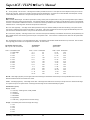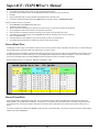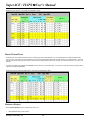
1
Atterbury
Consultants, Inc.
User’s Manual
3800 Cedar Hills Blvd., #145
Beaverton, Oregon 97005
Phone: (503) 646-5393
Fax: (503) 644-1683
http://www.atterbury.com
e-mail: [email protected]
SuperACE / FLIPS™ User’s Manual
Table of Contents
Welcome to FLIPS ............................................................................................................ 1
Welcome to SuperACE ..................................................................................................... 1
SAMPLING ........................................................................................................... 2
Key To Timber Cruise Sampling Method .......................................................................... 2
Sampling Methods ............................................................................................................ 3
Sampling Design and Intensity.......................................................................................... 5
DATA INPUT ........................................................................................................ 5
TC - Dbh Cru/Cnt .............................................................................................................. 5
TC - Extra Tree Measurements......................................................................................... 6
FI - History/Planning Screen ............................................................................................. 6
FI - Land/Soils Screen....................................................................................................... 6
TC - Plot Loc ..................................................................................................................... 6
FI - Sort/Grade Screen ...................................................................................................... 6
FI - Spp Sum Screen......................................................................................................... 6
Stand Information Screen ................................................................................................. 6
FI - Stand Input Screen ..................................................................................................... 6
FI - Stand Table ................................................................................................................ 6
TC - Tree Edit Screen ....................................................................................................... 7
TC - Tree Input Screen ..................................................................................................... 7
Type Master Screen .......................................................................................................... 9
HOW TO ............................................................................................................. 10
Add and Remove ZM, ZP Types ..................................................................................... 10
Adjust Timber Cruise Volume ......................................................................................... 10
Adjust Inventory Volumes ............................................................................................... 11
Adjust Site Index ............................................................................................................. 11
Assign Tables to a Project .............................................................................................. 12
Backup a Project ............................................................................................................. 12
Change Communication (COM) Ports ............................................................................ 12
Change Report Parameters ............................................................................................ 13
Change Species, Sort or Grade Codes........................................................................... 13
Change a Tract Name ..................................................................................................... 14
Copy Cruise Plots ........................................................................................................... 14
Copy a Project................................................................................................................. 15
Copy a Stand .................................................................................................................. 15
Create or Add a Project................................................................................................... 15
Create a New Stand ........................................................................................................ 16
Create a New Table ........................................................................................................ 16
Delete a Project............................................................................................................... 16
Delete a Stand ................................................................................................................ 16
Delete a Table ................................................................................................................. 17
Delete Cruise Plots ......................................................................................................... 17
Download Data from Pocket SuperEASY™ to SuperACE 06™ ..................................... 17
Download Tables to Pocket SuperEASY™..................................................................... 19
Download Data from a CMT Unit .................................................................................... 20
Atterbury Consultants, Inc.
SuperACE / FLIPS™ User’s Manual
Download Tables From PC to CMT Unit ......................................................................... 20
Edit Plot Data .................................................................................................................. 21
Edit Project ...................................................................................................................... 21
Edit Tables ...................................................................................................................... 21
Enter Plot Data ................................................................................................................ 22
Explode a Stand .............................................................................................................. 24
Export a Report\Graph .................................................................................................... 25
Find a Stand .................................................................................................................... 25
Grow a Project ................................................................................................................ 25
Grow a Stand .................................................................................................................. 26
Import Cruise Data into Inventory ................................................................................... 26
Import a DOS-based FLIPS Project ................................................................................ 26
Import a DOS-based SuperACE Project ......................................................................... 26
Open a Type Master Screen ........................................................................................... 27
Open a Table .................................................................................................................. 27
Print a Report\Graph ....................................................................................................... 27
Print a Table .................................................................................................................... 27
Print a Window ................................................................................................................ 27
Query Stands .................................................................................................................. 27
Record Blank Plots.......................................................................................................... 28
Record Count Plots ......................................................................................................... 28
Record Count Trees ........................................................................................................ 29
Restore a Project ............................................................................................................ 29
Run Reports\Graphs ....................................................................................................... 30
Run a Stand Table Adjustment Cruise ............................................................................ 30
Select Multiple Stands..................................................................................................... 31
Select a Printer................................................................................................................ 31
Select a Project ............................................................................................................... 32
Select a Stand ................................................................................................................. 32
Start ForestVIEW ............................................................................................................ 32
Update Inventory from Cruise Data................................................................................. 32
Use Defaults Screen ....................................................................................................... 32
REPORTS .......................................................................................................... 33
Age Class - Conifer & Hardwood Summary Report ........................................................ 33
Age Class Distribution By Spp Type, Average Vol. per Acre Report .............................. 33
Catalog Species Volume Report ..................................................................................... 34
Catalog - Tree Classification Report ............................................................................... 35
Log Stock Table - MBF Report........................................................................................ 37
Log Stock Table - Percent Board Foot Report ................................................................ 37
Log Stock Table - Percent Cubic Feet Report ................................................................ 38
Non-Stocked and Non-Timbered Acres Report .............................................................. 39
Ownership Report ........................................................................................................... 39
Plot List Report................................................................................................................ 39
Species Sort/Grade Report ............................................................................................. 40
Species Summary - Logs and Volumes Report .............................................................. 41
Stand Table Summary Report......................................................................................... 41
Statistics .......................................................................................................................... 43
Timber Value Analysis Report......................................................................................... 43
Tract Summary Report .................................................................................................... 44
Tree Segment Volumes Report....................................................................................... 44
Atterbury Consultants, Inc.
SuperACE / FLIPS™ User’s Manual
Type Acres List Report.................................................................................................... 44
Volume Relationships by Species Report ....................................................................... 44
TABLES ............................................................................................................. 45
Adjustment Tables .......................................................................................................... 45
Age .................................................................................................................................. 45
Aspect ............................................................................................................................. 46
Category.......................................................................................................................... 46
Cost Table Overview ....................................................................................................... 46
T1-Crown Position........................................................................................................... 46
T2-Crown Ratio ............................................................................................................... 47
Component...................................................................................................................... 47
Cruise System ................................................................................................................. 47
T4-Damage ..................................................................................................................... 47
Environment .................................................................................................................... 47
Harvest ............................................................................................................................ 48
History/Planning .............................................................................................................. 48
Landform ......................................................................................................................... 48
NonStock......................................................................................................................... 48
NonTimber ...................................................................................................................... 48
Price Table Overview ...................................................................................................... 49
Roads .............................................................................................................................. 49
Seed Zone....................................................................................................................... 50
Slash ............................................................................................................................... 50
Soils ................................................................................................................................ 50
Sort/GradeTable Overview.............................................................................................. 50
Species Table Overview ................................................................................................. 51
Status .............................................................................................................................. 52
Streams ........................................................................................................................... 53
Tax .................................................................................................................................. 53
Treatment ........................................................................................................................ 53
TreeSource ..................................................................................................................... 53
T3-Vigor .......................................................................................................................... 53
Vegetation ....................................................................................................................... 54
WoodType ....................................................................................................................... 54
LINKING FLIPS TO A GIS SHAPEFILE ............................................................ 54
Reasons for linking to FLIPS........................................................................................... 54
Organizing Shapefiles ..................................................................................................... 54
Processing ...................................................................................................................... 55
Initiating the Link to Flips................................................................................................. 57
Selecting the FLIPS Project ............................................................................................ 58
Filling in the Match Fields Area ....................................................................................... 58
Filling in the Buffers Area ................................................................................................ 59
Matching the Data ........................................................................................................... 59
Making Choices for the FI/GIS-Matched Area ................................................................ 60
Back to FLIPS ................................................................................................................. 61
TECHNICAL SUPPORT ..................................................................................... 62
Before Calling for Technical Support .............................................................................. 62
Calling ACI Technical Support in the United States ........................................................ 62
Atterbury Consultants, Inc.
SuperACE / FLIPS™ User’s Manual
Customer services .......................................................................................................... 62
Training Services ............................................................................................................ 63
How to Find a Class Near You or Set up Customized Training ...................................... 63
Atterbury Consultants, Inc.
SuperACE / FLIPS™ User’s Manual
Welcome to FLIPS
Atterbury Consultants is pleased to bring you FLIPS, the windows version of our Forest Land Inventory and Planning System (FLIPS). Finally, a
user-friendly, flexible working environment to assist you in completing all of your forest inventory projects. Below is a brief list of some of the exciting
new features available with FLIPS.
Stand View
•
View stands by species, D4H, and sort/grade.
•
Update growth and create new sort/grade records using old sort/grade records.
Flexible Database Design
•
Manipulate database easily due to component design.
•
Attach more project information such as customer name and address, project leader, etc.
•
Include external information from sources such as satellite images, aerial photos, and ForestVIEW projects.
Interface with a GIS
•
Update GIS data with FLIPS and vice versa.
•
Create new inventory data from within a GIS.
Seamless Integration with Timber Cruise
•
Interchange data between FLIPS and our new timber cruise software, SuperACE (if you have purchased this).
•
View plot and tree level data in the SuperACE timber cruise program directly from FLIPS.
Import Data from DOS Versions of our Forestry Software
•
Effortlessly import data created in MS-DOS versions of FLIPS and SUPERACE.
Generate Numerous Reports and Graphs
•
Create reports and graphs for an entire project, individual stand, or selected stands.
•
Use the new “Data Selector” to produce reports and graphs based on data selected by user-defined stand parameters.
Welcome to SuperACE
Atterbury Consultants is pleased to bring you SuperACE, the windows version of our Super Accurate Cruise Extension program. Finally, a userfriendly, flexible working environment to assist you in completing all of your timber cruising projects. Below is a brief list of some of the exciting new
features available with SuperACE.
Seamless Integration with FLIPS
Import Data from DOS Versions of our Forestry Software
Menu Driven
On-line Help
Flexible Database Design
Multiple sampling systems
Generate Numerous Reports and Graphs
Variable log lengths
User defined tables
Timber cruise and reforestation input
Atterbury Consultants, Inc.
1
SuperACE / FLIPS™ User’s Manual
Sampling
Forests are generally too large and have too many trees for a 100% inventory of every tree. Limited time and money for cruising usually dictates that
the population be sampled. Samples are collected that hopefully will represent the entire population. Sampling has to be done in a way that the
answers are still reliable. Reliability comes only when the stratification is done properly, the acres are calculated correctly, the right sampling method
is used, the trees are measured or estimated correctly, and data are properly extended to useful information.
There is always some risk of not having the right answer when sampling. Bias can cause a systematic distortion. This can be caused by using the
wrong sampling system, bad measurements, or poor estimates. This can only be avoided by cruiser training and continually measuring all of the
parameters all day, every day.
Accuracy means the estimates are close to the true values. Often, cruisers will measure one parameter, such as DBH with great precision, and
guess all of the heights and have very inaccurate cruise. The measurement effort must be balanced among all parameters in all species to avoid
bias and error.
The populations in forests are often variable. Every tree can have a different volume and balance and every acre a different volume and value. This
variation is measured by installing a series of samples spread over the entire population.
SuperACE calculates and reports a “Statistical Summary” for each timber type. Variation and Standard Error are calculated for basal area, net cubic
feet per acre, and net board feet per acre. The confidence limits are printed for each parameter for a given standard deviation. Usually foresters use
one standard deviation, or that the average will fall in the confidence limits 67% of the time.
The statistical calculations are done after the cruise is complete. Rarely is it feasible to go back to the forest and take more samples. The cruiser
must decide before starting the cruise, what kind of sampling system to use, what kind of plots to take, and how many plots to establish.
Stratifying the forest into homogeneous types usually brings the Coefficient of Variation in normal forests to around 50%. We have found that 30 to
40 proportional plots with an average of 4 to 6 trees per plot, or a total of around 150 sample trees will yield accurate answers that will cut-out around
+ or –10%, 67% of the time. Stands with more variation require more plots. Count plots should be used when the basal area per acre varies more
than the volume per acre. Count plots only measure species and basal area per acre.
Common sense and a basic knowledge of the various sampling systems are more important than sampling theory.
Key To Timber Cruise Sampling Method
To use this key, make estimates based on observation, aerial photographs, comparable data and personal knowledge of the timber stand. Record the
following stand conditions:
1. total height
2. average diameter
3. acres
4. stand structure
Start at the top of the key and review each of the conditions about the stand. Select the sampling method to which the key leads.
REFORESTATION CRUISES: (Trees up to 20 feet tall)
Stocking variable ...................................................................................................... Variable Radius
Stocking even; density adequate ............................................................................. Fixed Area
TIMBER CRUISES: (Trees over 20 feet)
Small area up to 10 acres
Area known
Small trees up to 8” .................................................................................. Fixed area
Few large trees ........................................................................................ 100 %
Many large trees ...................................................................................... Strip or fixed
Area unknown
Few trees ................................................................................................. 100 %
Atterbury Consultants, Inc.
2
SuperACE / FLIPS™ User’s Manual
Many trees ............................................................................................... Strip
Larger area over 10 acres
Area known
Small trees up to 8” .................................................................................. Fixed area
Tree over 8” ............................................................................................. Prism
Even aged stand with large tree overstory .............................................. Prism plots plus 100 %
Variable Stocking ........................................ ............................................ Prism plus count plots
Homogeneous stand (Spp and DBH) ...................................................... Prism plus count trees
Area unknown ........................................................................................ Strip
Sampling Methods
Reforestation Cruise
Reforestation surveys are used in stands with heights of less than 20 feet. Timber stands taller than 20 feet have measurable volume and should be
sampled with a timber cruise program. Reforestation surveys are entered in the TC-Tree Input screen of SuperACE by placing R1, R2, R3, R4 or R5 in
the PF column to indicate a fixed radius reforestation plot. Values are assigned to the R1 thru R5 factors on the type master screen. For example, if
th
you’re running a stocking survey with 1/100 acre plots, R1 is entered in the PF column for each tree record. In the type master screen a value of 11.78
th
(plot radius, in feet, for a 1/00 acre plot) is entered in the cell next to R1. Values for R2 thru R5 are left blank since only one plot radius was used in the
survey. All blank plots must be recorded in order to calculate stocking. All blank plots must be recorded in order to calculate stocking. Blank plots are
recorded by entering a plot number, species code and 0 in the Ct. column.
100 % Cruise
This is not a sampling method, but rather a complete or 100% cruise of the entire population. This is rarely feasible. Do not attempt a 100% cruise
unless you are absolutely sure all trees can be identified and measured. A 100% cruise tree is entered in SuperACE by preceding the plot number with a
dash (-). For example –001. Or, use S1 in the PF column for the tree and assign a value of “1” in the type master screen.
Situations for use:
1.
A cruise of one tree.
2.
Marked trees along a right-of-way.
3.
A few (less than 100) large scattered trees in a reproduction type which can be easily identified.
4.
A few scattered, large trees of a merchantable type, which are usually a different species, age, and of high value; i.e.,older
Douglas-fir trees in a younger stand. The younger trees may be prism cruised while the more valuable Douglas-fir trees should
be 100% cruised.
Advantages
1.
No sampling.
2.
Provides a record of every tree.
Disadvantages
1.
2.
3.
100% cruises are expensive. The higher costs must be justified by specific requirements which cannot be obtained otherwise.
Possibility of missing trees.
Possibility of cruising trees twice.
Strip Cruise
A strip cruise is a cruise of a percentage of the total type area or number of trees. Continuous strips are run through the tract at regular intervals. A strip
cruise is entered in the tree input screen of SuperACE by entering S1, S2, S3, S4 or S5 in the PF column for each tree record. A strip cruise “blow-up”
factor is entered as a whole number on the type master screen. For example, if each tree cruised represents 5 trees (a 20% cruise) then a “5” is entered
Atterbury Consultants, Inc.
3
SuperACE / FLIPS™ User’s Manual
next to S1 on the type master screen. Values for S2 thru S5 are left blank since only one strip “blow-up” factor was used in the cruise.
Situations for use:
1. Areas of unknown size.
2. Irregular shaped areas.
3. Irregular area with field around it.
4. Road right-of-way laid out in timber.
5. Narrow strip where powerline right-of-way is widened.
6. Brushy areas or areas with broken topography where prism cruising would not work.
Acreage’s by types must be calculated with a strip cruise; however, they are only used to calculate volume per acre. The total volumes are calculated by
multiplying the volume of each tree times the strip area factor.
There is no balancing of diameter and trees per acre as in a prism cruise. If the diameters are estimated too small in a strip cruise, the volume will be
low.
Advantages
1. Strip cruises can avoid critical acreage errors in small units.
2. Blow-up factors can be independent of acreage.
3. Brushy areas with scattered trees can be cruised accurately.
Disadvantages
1.
The entire tree distribution will be sampled, which may mean that many small trees will have to be recorded. These small trees
add greatly to the cost of cruising but may not add to the volume and value.
2.
An accurate baseline has to run completely through the number of strips for cruise % control.
3.
Accurate strip widths placed at right angles to the baseline have to be constantly maintained with frequent checking of borderline
trees. The strip center must be accurately marked in order to do this.
Fixed Area Plots
These are usually fixed circular plots of a certain size. These plots should be large enough to sample the population with an average of 5-10 trees
per plot. The radius of the plot must be larger than the radius of the square of the actual stocking.
Plot Radius = sq.rt. (13,865.58*plot area)
Five fixed area plots can be nested in a plot. They are indicated on the plot card or data recorder with an F1, F2, F3, F4 or F5 in the PF column and
the plot size defined on the type master screen. A plot radius is entered on the type master screen as decimal factor. For example, a ¼ acre plot is
entered as 0.25.
Proportional Plots, Variable Radius Plots, Prism Plots
These are the most popular plots for cruising merchantable timber today. A BAF should be selected to yield an average of 5 trees per plot. Use the
same BAF for the entire type or strata. SuperACE allows BAF of any number between 1 and 99.99. BAF that are whole numbers can be put directly
in the PF cloumn on the plot card or in the cruise input screen. BAF that have a decimal number are assigned in the type master screen and coded
on the plot card or data recorder as B1, B2, B3, B4, or B5.
More than one BAF can be used in a type to sample various species or size groups.
Combination Sampling Systems
Types that have mixed species of extreme value, or a wide diversity in age or size, may have to be sampled with more than one system or plot size
at the same time.
Nested plots can be used for many situations.
Merchantable stands, with a few scattered large trees, can be cruised with a BAF for the merchantable element and with a 100% or a strip used for
the large trees.
Atterbury Consultants, Inc.
4
SuperACE / FLIPS™ User’s Manual
Merchantable stands, containing a minor species of high value, can be cruised using a combination of prism for the major species and a strip cruise
for the high value minor species.
Sampling Design and Intensity
1.
2.
3.
Determine the accuracy needed for the project or each sampling unit (type). Prioritize the sampling intensity to the highest value, largest,
nearest to operations or highest volume per acre.
Stratify the ownership into sampling units (types) or operational units that can be sampled. Each type may be sampled with a different method
and intensity.
The number of plot and tree samples is a function of the needed accuracy and the variation with the sampling unit. Stratification can reduce the
number of plots needed to satisfy accuracy. Statistical calculations of the samples will determine the actual sampling error. Estimating the
number of plots needed for the accuracy comes more from experience than from statistical calculations before the sampling is started.
Statistics from old cruises in an area can help in judging the number of plots that are required for a certain accuracy on types to be sampled.
Average timber types have coefficient of variation of around 40 – 50% and can be sampled to about +/-10% at 1 standard deviation with 30 to
40 plots. Proportional plots require about 4-6 trees average or 120 to 240 trees. Stands with more variation require more plots or trees. To
reduce the error by half requires four times the samples.
Determine the number of sample trees per plot.
Proportional plots determine the BAF by estimating the basal area per acre and divide by 5 trees.
Example:
BAF = 100 sq. ft. per acre/5 trees = 20
Fixed area plots estimate the trees per acre and divide by 10
Example:
th
Plot Radius = 200 trees per acre / 10 = 20 acre = plot radius of 26.33 feet.
Determine plot spacing.
Square grid = sqrt ((43,560 x type acres) / (number of plots))
Example:
Total acres = 44
Plots = 44
Square grid = sqrt((43,560 x 44) / (44)) = 208.71 feet.
Acres per plot = (plot spacing)^2 / 43,560 = (208.71)^2 / 43,560 = 1.00
Rectangular grid = Spacing between lines = (Acres x 43,560) / (# plots x distance between plots)
Example:
Total acres = 44
Plots = 44 Distance between plots = 132’
Spacing between lines = (44 ac. X 43,560) / (44 plots x 132’) = 330’
Acres per plot = (distance between plots x spacing between lines) / 43,560 = (132’ x 330’) / 43,560 = 1.00
Lay out the plot lines on the maps to cross drainages and other patterns that may cause the sample to be in error. The acres per plot should be
multiplied by the number of plots in each type to check the acres calculations and the plot count.
Measure the results.
Statistical calculations should be computed for each type, the average for all types and possibly the standard error for the entire project. Cut-out
records should be kept to check the actual against the estimated. Measurement errors must be considered. Measure the right things for quality
results.
Data Input
TC - Dbh Cru/Cnt
The TC – Dbh Cru/Cnt screen is accessed via the TC – Dbh Cru/Cnt tab of the stand information screen. This screen gives a stand table
summation based on the cruise data in the selected stand. It can also be accessed in the TC – Tree Input and TC – Tree Edit screens by clicking on
the Stand Table button. The diameter class can be adjusted in the “Dia. Class” cell and the diameter class mid-point is defined in the “Round up on”
cell. The changes take affect by pressing on the Enter button after entering the change. The other variable cells are not active at this time.
Atterbury Consultants, Inc.
5
SuperACE / FLIPS™ User’s Manual
TC - Extra Tree Measurements
The TC – Extra Tree Measurements screen is accessed by clicking the TC – Extra Tree Mea tab of the stand information screen. This screen stores
site tree measurements. The measurements include species, DBH, total ht., age code, BH age, total age, DBH growth, height growth, and bark
thickness.
FI - History/Planning Screen
The History/Planning screen is accessed by selecting the FI-History/Plan tab on the stand information screen. It allows you to enter history or
planning activitiesalong with date, acres, cost/unit and units (A=Acres, M=MBF, C=CUNITS, T=TONS) associated with individual timber types in a
project. Click on the History tab at the bottom of the History/Planning screen to enter information on stand history. Alternatively click on the Plan tab
to enter information on planning for the stand.
FI - Land/Soils Screen
The Land/Soils screen is accessed by selecting the FI - Land/Soils tab of the stand information screen. It allows you to enter landform, soils, road
construction, tax, seed zone, habitat, harvest system, stream class, and environmental information that needs to be associated with the stand.
TC - Plot Loc
The TC – Plot Loc screen is accessed via the TC – Plot Loc tab of the stand information screen. This screen allows the user to input, through
keyboard or data recorder download, direction of travel, coordinates (state plane, latitude/longitude, or UTM system), slope, aspect, and habitat
description for each cruise plot.
FI - Sort/Grade Screen
The Sort/Grade screen is accessed by clicking on the FI – Sort/Grade tab of the stand information screen. It is the most detailed view of the stand
information. It is similar to both the Species Summary and Stand Table views of the stand data, except that it is broken down further into the
individual sort and grade combinations for each species of a given log dib. It then includes the remaining information of logs per acre, Gross and Net
Cubic Feet per Acre, and Gross and Net Board Feet per Acre.
FI - Spp Sum Screen
FI – Spp Summary Screen is accessed by clicking on the FI – Spp Sum tab on the stand information screen. The table that appears in this screen
lists summarized information about the species in the stand. This information includes the species name, the average age, DBH, Site Index, Basal
Area per Acre, Trees per Acre, Logs per Acre, Total Height, Gross and Net Cubic Feet per Acre, and Gross and Net Board Feet per Acre.
Stand Information Screen
Each stand in a project is accessed through a stand information screen. It is a collection of dialog screens that contain all the data associated with a
given stand in a project. This includes stand information such as location, associated cost and price tables, cruiser name, etc.; tree details; stand
history and planning; land and soils information; and GIS information. In this dialog the user can add or edit information via the Stand Input screen.
It is also possible to move through the list of stands in the selected project using the four buttons, First, Previous, Next, and Last.
FI - Stand Input Screen
The FI - Stand Input screen is accessed by clicking the
button located on the opening screen tool bar after the desired stand has been
selected. It can also be accessed by clicking on the Stand Input tab of the stand information screen. It is the screen where new stand data is
entered. It includes Species, Status, Age, Birth Year, Site Index, Normality, Basal Area per Acre, Trees per Acre, DBH, Logs per Acre, Gross and
Net Cubic Feet per Acre, and Gross and Net Board Feet per Acre. The attributes shaded in green (Spc, Age, site index, and Trees/AC) are the
minimum stand attributes which must be entered in order to calculate a stand yield. If cruise data is present in SuperACE for the timber type, then
the cruise data can be used to populate the Stand Input screen. This is performed by selecting the stand in the project screen, then selecting Cruise
to Inventory under the File menu on the menu bar.
See Also
Creating a New Stand
FI - Stand Table
FI - Stand is the third tab of the stand information screen and is a detailed view of the stand information. It is similar to the FI - Species view of the
stand data, except that each species is broken down by DBH . It then includes the remaining information of Site Index, Basal Area per Acre, Trees
per Acre, Logs per Acre, Height per Tree, Gross and Net Cubic Feet per Acre, and Gross and Net Board Feet per Acre.
Atterbury Consultants, Inc.
6
SuperACE / FLIPS™ User’s Manual
TC - Tree Edit Screen
This screen is accessed by clicking the TC – Tree Edit tab of the stand information screen. It shows the data as it was entered in the TC - Tree
Input screen along with the computed values and error messages for each log segment. This screen is used to edit the tree data that was entered in
the TC - Tree Input screen. The tree data is edited directly into the screen cells and through the insert segment, delete segment, insert tree, delete
tree, and replace buttons located at the bottom of the screen.
Computed ( These fields are calculated automatically by the program.)
Cum Ht. − Cumulative Height − Height of segments including trim.
Top DOB − Top Diamater Outside Bark − The small end of the log, outside the bark, as specified in the scaling rule.
Top DIB – Top Diamater Inside Bark − The small end of the log, inside the bark, as specified in the scaling rule.
Net CuFT – The cubic feet in a log less defect deductions.
Net BdFt – The board feet in a log less defect deductions.
If a tree segment does not meet any of the parameters defined in the species or sort and grades tables an error message will appear in red to the
right of the computed fields. Once the segment is edited the message will disappear.
TC - Tree Input Screen
The TC – Tree Input Screen is accessed by clicking on the TC – Tree Input tab of the stand information screen. It is this screen where timber cruise
plot data is entered. The data is entered directly into the screen cells and through the insert tree, delete tree, and replace buttons located at the
bottom of the screen.
Plot No. - Plot Number (required). A Four digit plot number, alpha/numeric, is assigned to each plot. Each plot in a timber type must have a unique
number. Duplicate plot number will be computed as one plot. The program will check for duplicate plot numbers when you start entering a plot.
Plot numbers should be pre-assigned when more than one cruiser is taking plots in a type.
Tree No. - Tree Number. A three digit numeric field. Tree number is assigned by the computer except when measuring permanent plots. Users
input tree numbers when measuring permanent plots for growth and each tree is going to be measured more than once.
PF – Plot Factor or Prism Factor (required). A two digit alpha numeric field. When a two digit number is entered, the field is a Prism Factor or Basal
Area Factor ( i.e. 20 equals a 20 BAF). If a decimal value is used for a prism factor then a B1, B2, B3, B4 or B5 is entered with the prism factor value
defined in the type master screen (i.e. B1 is entered in the PF column and 33.61 is entered next to B1 in the type master screen). Glass prisms
should always be checked for the proper prism factor. A letter followed by a number (i.e. F1, R1 or S1) is referring to a Plot Factor in the type master
screen. These refer to various sampling systems and plot sizes. If a cruiser requires that a tree be treated as a 100% cruise tree on a cruise plot,
enter the tree on a plot with the plot number preceded by a dash (-).
Up to 5 options for each sampling system can be used:
System
Option
Example (As entered in the Cruise Master Screen)
Basal Area Factor:
Fixed Area Plots:
Reforestation Plot Radius:
Strip Cruise Blowup:
B1 thru B5
F1 thru F5
R1 thru R5
S1 thru S5
B1 = 27.78
F1 = 0.25 (One quarter acre plot)
R1 = 11.78 (1/100 acre plot)
S1 = 4.00 ( 25% strip cruise)
Identification
A. −Age (required): A one digit numeric field for age code. The age in years is input on the cruise master screen. Default age is code 1. Up to nine
ages can be input per type. Age is used for calculating the tree form, bark factors, growth, and for age class reports. If no age is assigned, then a
default age of 30 is used for volume calculations.
Spp. – Species (required): A six digit alpha/numeric field is provided for species. The numbers or letters must match the active species screen. A
species table must be active before the cruise data is entered. Species is very important. It is usually not a good idea to group species. Each
individual species should be entered on the species table with appropriate factors and limits.
St. – Status (optional): A one digit alpha/numeric field. Input must match codes in the status table. Status is used to indicate dead trees, etc.
Ct. − Count (optional): The tree count. A two digit numeric field is provided for tree count. Count plots are used to adjust the trees per acre for the
trees on the cruise plot. Trees can be counted on the plots by species and diameter. Count plots can be used with BAF, fixed area plots, and strip
cruises. Blank plots are entered as a count plot with a species code and a 0 in the Ct. column.
Atterbury Consultants, Inc.
7
SuperACE / FLIPS™ User’s Manual
Measurements
DBH – Diameter Breast Height: This field is required when cruising volume plots and optional when cruising count and regeneration plots. DBH is a
four digit numeric field, including the decimal point, is provided for diameter. This diameter is measured four feet or 1.3 meters above the stump
outside the bark. Diameters less than 99.9 inches can be input to the nearest tenth inch. Trees larger than 100 inches are input to the nearest inch.
FP – Form Point (required) – A two digit numeric field is provided for form point. Default is DBH (four feet above the stump). Form point is where
Form Factor is measured and/or where the tree taken “in” with a BAF. If form point is defined as four feet, the program will automatically use a form
point of 16 feet to calculate Form Factor. Form point can be varied for each tree if needed.
FF – Form Factor (required) – A two digit numeric code. Form factor is the percent relationship of the diameter at Form Point (16 feet) divided by the
DBH. Default values for Form Factor by species are input on the species screen. If no form factor is entered, the form factor from the species table
will be used.
TD – Top Diameter (required). A one digit alpha/numeric field. Top diameter is the diameter outside the bark at the top of the bole. This is entered
as a single digit percent value or as an alpha value for diameter. As shown below.
Top Diameter Fractions of FP
TDF = top dia. / dia. at Form Point
Code = % of diameter at FP
0 = Total Height
1 = 10%
2 = 20%
3 = 30%
4 = 40%
5 = 50%
6 = 60%
7 = 70%
8 = 80%
9 = 90%
Top Diameters
Alpha Codes
Code = Inches
A=1
B=2
C=3
D=4
E=5
F=6
G=7
H=8
I=9
J = 10
K = 11
L = 12
M = 13
Top Diameters
Alpha Codes
Centimeters
2.5
5.0
7.5
10.0
12.5
15.0
17.5
20.0
22.5
25.0
27.5
30.0
32.5
Code = Inches Centimeters
N = 14
35.0
O = 15
37.5
P = 16
40.0
Q = 17
42.5
R = 18
45.0
S = 19
47.5
T = 20
50.0
U = 21
52.5
V = 22
55.0
X = 23
57.5
W = 24
60.0
Y = 25
62.5
Z = 26
65.0
Bole Ht. – Bole Height (required)– A three digit numeric field. Bole height is the distance from the stump to the Top Diameter Fraction or the Top
Diameter outside the bark to the nearest foot.
Tot Ht. − Total Height (optional) − A three digit numeric field. Total height is the distance from the stump to the tip of the tree. Maximum tree height
for a species is input on the species screen. Bole height and tree height can be entered individually or together. If a “0” (zero) is entered in the TD
cell then the Bol Ht value will be automatically copied to the Tot Ht cell.
Classification (optional)
Po (T1) – Position
O = over-story – Older age trees, usually residual
D = dominant
C = co-dominant
I = intermediate
S = suppressed
U = under-story – younger trees than the main canopy
CR (T2) – Crown Ratio percent of the tree length with canopy.
1 = 10%
2 = 20%
3 = 30 %
4 = 40%
5 = 50%
6 = 60%
7 = 70%
8 = 80%
9 = 90%
Atterbury Consultants, Inc.
8
SuperACE / FLIPS™ User’s Manual
Vi (T3) – Vigor
H = healthy, living tree, may have damage
M = alive, but damaged and/or is not normal.
D = dying
Da (T4) – Damage
A = animal damage, unknown species
B = bear
C=
D = deer
E=
F = fire
G=
H=
I = insects
J = J rooted when planted
K=
L=
M=
N=
O=
P=
Q=
R=
S=
T5 – other
Segments - Up to 12 Segments can be described for each tree (required for volume calculation).
S# - Segment number – two digit automatically assigned by the program. This includes cull segments, breakouts and logs.
S − Sort − A single alpha or numeric code as described in the active sort/grade table.
G − Grade − A single alpha or numeric code as described in the active sort/grade table.
Ln – Segment length. Two digit numeric. On the final log segment of a tree, a “- -“ may be entered instead of a numeric length. If a “- -“ is entered,
the program will compute the length of the segment to the minimum top diameter. Log length min and max are defined in the species, sort and grade
tables.
Bd. Ft. F. − Board Foot length deductions.
I. – Board Foot diameter deductions
Cu. Ft. F. – Cubic Foot length deductions
I. – Cubic Foot diameter deductions
% − Numeric field left blank when using length or diameter deductions. A 1 is entered when percentage deductions for both board foot and cubic
feet are to be used. Percentages are entered as whole numbers in the F. I. cells of a tree segment (i.e. 10 equals 10% and 05 equals 5%).
Type Master Screen
The screen is accessed by double clicking on the gray area to the left of the TWN number. This screen contains all the inventory and cruise
information associated with a given type (stand) in a distinct township, range, and section location. This includes information such as location, tract
name, type number, stand size, cost and price tables, cruiser name, site index, BAF, age, etc. A master is either created by hand entering values,
or by copying or exploding a stand. The master is the first screen that appears when the stand information screen is opened.
See Also
Stand Information Screen
Atterbury Consultants, Inc.
9
SuperACE / FLIPS™ User’s Manual
How To
Add and Remove ZM, ZP Types
The purpose of ZM and ZP types is to adjust section acres to match legal acres for sections which have legal acres listed in the ownership list by
adding a ZM or ZP type to a section. The original type acres in a section are not affected by the process. A ZM type (minus acres) will reduce
section acres to equal legal acres for a section. A ZP type (plus acres) will add acres to a section to equal the legal acres for a section. The
adjustment is automatic.
To add ZM,ZP types:
1.
2.
3.
4.
Select the Project you wish to adjust.
From the menu bar select Ownership.
Select Add ZM, ZP Types from the drop down menu.
ZM and ZP types are added automatically.
To remove ZM, ZP types:
1.
2.
3.
4.
Select the Project you wish to adjust.
From the menu bar select Ownership.
Select Remove ZM, ZP Types from the drop down menu.
ZM and ZP types are removed.
Adjust Timber Cruise Volume
Timber cruise volumes can be adjusted over an entire project or individual stands. These adjustments only occur when a cruise report is run. The
original cruise data is not effected. If an adjustment is applied then the name of the adjustment table is displayed in the Cru Adj window on the stand
information screen.
1.
2.
3.
From the menu bar select either project or stand, depending on the level of adjustment.
Choose adjustments from the drop down menu.
The adjustments dialog screen appears.
4.
5.
6.
7.
8.
9.
10.
Select Cruise and Volume Adjustment.
Click on the Adjustment Table button in order to edit the adjustment parameters or to create a new adjustment table.
In the adjustment pull down window select the table you wish to run the adjustments against.
Click OK
From the cruise reports selection screen, select the report to run and check the Apply Cruise Adjustments box at the bottom of the screen.
Click the Process button.
The volumes calculated in the reports will include the adjustments.
See Also
Adjustment Tables
Atterbury Consultants, Inc.
10
SuperACE / FLIPS™ User’s Manual
Adjust Inventory Volumes
Timber inventory volumes can be adjusted over an entire project or individual stands. Volume adjustments are applied to the original inventory data.
Therefore, stands that have been adjusted must be grown in order to calculate the results of the adjustments. If an adjustment is applied then the
name of the adjustment table is displayed in the Inv Adj window on the stand information screen. Caution should be used when applying
adjustments.
1.
2.
3.
From the menu bar select either project or stand, depending on the level of adjustment.
Choose adjustments from the drop down menu.
The adjustments dialog screen appears.
4.
5.
6.
7.
8.
Select Inventory and Volume Adjustment.
Click on the Adjustment Table button in order to edit the adjustment parameters or to create a new adjustment table.
In the adjustment pull down window select the table you wish to run the adjustments against.
Click OK
Original inventory volumes are adjusted according to parameters set in the adjustment table.
See Also
Adjustment Tables
Adjust Site Index
Site index can be adjusted for inventory data over an entire project or individual stands. Site index adjustments are applied to the original inventory
data. Therefore, inventory stands that have been adjusted must be grown in order to calculate the results of the adjustments. If an adjustment is
applied then the name of the adjustment table is displayed in the INV window on the stand information screen. Caution should be used when
applying adjustments.
1.
2.
3.
From the menu bar select either project or stand, depending on the level of adjustment.
Choose adjustments from the drop down menu.
The adjustments dialog screen appears.
4.
5.
6.
7.
8.
Select Inventory and Site Index Adjustment.
Click on the Adjustment Table button in order to edit the adjustment parameters or to create a new adjustment table.
In the adjustment pull down window select the table you wish to run the adjustments against.
Click OK
Original site index values are adjusted according to parameters set in the adjustment table.
Atterbury Consultants, Inc.
11
SuperACE / FLIPS™ User’s Manual
See Also
Adjustment Tables
Assign Tables to a Project
Each project has four primary groups of tables associated with it: Species, Sort/Grade, Price, and Cost tables (screens). At any time, the project may
refer to any one of a number of different tables, within each of these primary groups.
There are two methods to set default tables. The first method is the recommended procedure.
Method One:
1. Choose Defaults from the Setup drop down menu.
2. The defaults screen appears.
3. If the Tables screen isn’t visible click on the tables tab.
4. Click in the field next to the table category you wish to change.
5. Use the drop list arrow button to show a list of available tables
6. Click on the table you require.
7. Click OK.
Method Two:
1. Choose Tables from the menu bar
2. From the drop down menu choose a table category.
3. Click on the table name you require in the upper left corner of the screen.
4. Click the Make Default button.
5. Close the Tables screen.
Backup a Project
Backing up data is recommended after any significant changes have been made to a project. The data is stored in a zip file format (i.e. filename.zip)
and can be saved to a hard drive, tape drive, zip drive, or floppy disks. The zip file contains the data in an Access file format and has an MDB
extension (i.e. filename.mdb).
Select the Backup\Restore option in the File drop down menu.
1.
2.
3.
4.
Backup\restore dialog screen appears.
Select the tab labeled Backup.
Select a project to backup from the project list window.
Type or browse to where you want it stored (i.e. hard drive or floppy disk).
5.
Check the boxes if you want to include tables and multi volume in backup.
6.
Click OK.
See Also
Restore a Project
Change Communication (COM) Ports
When the software is installed, com port 1 is set as the default serial port for communication between the PC software and data collector software.
It may be necessary to change this setting on some PC’s due to other input devices utilizing com port 1 (i.e. mouse). The com port settings are
stored in the flips.ini file which is located under the C:\windows\ directory (Windows 98), C:\Winnt\ directory (Windows 2000/XP).
To change the com port setting:
1.
2.
Open the flips.ini file using notepad or an editor software application.
The file will look similar to this:
[Directories]
Atterbury Consultants, Inc.
12
SuperACE / FLIPS™ User’s Manual
FlipsDir=C:\FLIPS04\
CurrDB=C:\FLIPS04\DEMO\DEMO.mdb
CurrDataDir=C:\FLIPS04\DEMO
[Setup]
ID=3CE3 4018
CruFlag=1
InvFlag=1
Company=***
ComPort=1
ConvBoise=1
Customer=DEMO
ReportWeyco=1
ReportMB=1
ReportBoise=1
ReportHampton=1
[ForestVIEW]
PassDataDir=C:\FV37
[Project]
CurrProject=DEMO
3.
4.
5.
6.
Near the bottom of the [Setup] section is the statement “ComPort=1”.
Simply change the “1” to a different com port number (i.e. ComPort=2).
Save the flips.ini file and close.
Communications will now utilize the new com port setting.
Change Report Parameters
Report parameters are accessed by choosing Reports on the opening menu bar. Then choose Parameters and Log Stock Table or Project
Summary by Species, Sort, Grade from the drop down menu. Assign min. and max. values as needed and click OK. All cells must have a value.
Change Species, Sort or Grade Codes
Situations may arise where it will become necessary to change species, sort or grade codes in a type or project. An example would be if a cruiser
mistakenly used a different set of species, sort or grade codes than the other cruisers on a cruise job. In order to make all the data consistent, the
cruiser’s codes will need to be changed before the data can be processed. Instead of editing each tree entry one at a time the codes can be
changed globally on a stand or project by using the Change Species, Sort, Grade option under Project and Stand on the menu bar. Codes can be
changed in SuperACE only.
Change Species, Sort or Grade at the PROJECT Level
1.
2.
3.
4.
Select the project to be processed.
Click on Project from the menu bar.
Click on Change Species, Sort, Grade from the Project menu.
The following screen appears.
Atterbury Consultants, Inc.
13
SuperACE / FLIPS™ User’s Manual
The codes shown under the “Old” column are the current codes assigned to the data.
5.
6.
7.
Under the “NEW” column enter the codes that are to replace the old codes. If an old code is still to be used, leave the new cell blank. Each
time a code is entered in a cell, be sure to hit the enter key.
Be sure that the new codes are consistent with the tables associated with the project. After all the entries have been made click on the OK
button.
The codes are now changed for the whole project.
Change Species, Sort or Grade at the STAND Level
1.
2.
3.
4.
5.
Select the stand to be processed.
Click on Stand from the menu bar.
Click on Change Species, Sort, Grade from the Stand menu.
Follow steps 4 through 6 from above.
The codes are now changed for the selected stand.
Change a Tract Name
Use the following method If you have a stand or stands in which the tract name needs to be edited or changed.
1.
2.
3.
4.
5.
6.
7.
8.
9.
10.
11.
12.
13.
14.
15.
Backup your data.
Select a stand or stands with a tract name that requires editing.
Choose Maintenance from the Stand drop down menu. The Stand Maintenance dialog screen appears.
Select Copy and Cruise or Inventory from the Options area of the dialog screen.
Copy the stand(s) to a new temporary project by filling in the Destination Project and Destination Directory of where the temporary project is
to be stored.
Choose the Type tab at the bottom of the dialog screen if a single stand is to be copied, or select Section/Tract if the types associated with an
entire section or tract are to be copied.
In the Destination area of the table in the dialog screen, change the Tract name as needed. If the stand is to be linked to ForestVIEW, the
tract name can not exceed eight characters.
Click OK. The stand(s) are copied with the tract name changes into the temporary project.
Select the temporary project and verify that the stand(s) data has been copied correctly.
Select the original project and delete the original stand(s).
Select the temporary project and repeat steps 3 through 4.
Fill in the Destination Project and Destination Directory of the original project.
Click OK.
Select the original project and verify that the stand(s) data has been copied correctly.
Once you have verified that all the data has been copied correctly, you can delete the temporary project.
Copy Cruise Plots
1. Select a Stand.
Atterbury Consultants, Inc.
14
SuperACE / FLIPS™ User’s Manual
2. Click on Stand on the opening screen menu bar.
3. Choose Plot Maintenance from the drop down menu.
4. The Plot Maintenance dialog screen appears.
5. Confirm that orignal project and type are correct.
6. Check the copy option in the options area of the screen.
7. In the Destination area, fill in the legal description and type number of where the plots are to be copied.
8. Browse to the Destination directory of where the project is you want to copy to.
9. Choose a project (it can be within the same project) or enter the name of a new project.
10. Select the plots to be copied by selecting the cells of the plot numbers you want copied.
11. Click OK.
See Also
Delete Cruise Plots
Copy a Project
1.
2.
3.
4.
Choose Maintenance from the Project drop down menu. The Project Maintenance dialog appears.
In the Original window enter the name of the project you are copying from.
In the upper Destination window enter the name of the destination project.
In the lower Destination window use the browse button and browse to the directory where the destination project
is stored.
5. Select Copy in the options section and either Cruise or Inventory.
6. Click OK.
See also
Copy a Stand
Delete a Project
Delete a Stand
Copy a Stand
1.
2.
3.
4.
5.
6.
7.
Select a stand to copy.
Choose Maintenance from the Stand drop down menu. The Stand Maintenance dialog appears.
Select Copy and Cruise or Inventory from the Options area of the dialog.
Fill in the Destination Project and Destination Directory.
Choose the Type tab at the bottom of the dialog if a single stand is to be copied, or select Section/Tract if the types associated with an entire
section or entire tract are to be copied.
In the Destination area of the table in the dialog screen, change Twn, Rge, Sec, Tract and Type information as needed. If only the tract name is
to be edited, follow the directions in the on-line help for changing a tract name.
Click OK. The new stand is created in the new location.
See also
Change a Tract Name
Delete a Stand
Explode a Stand
Create or Add a Project
Build a new project from scratch or add an existing project.
1. Choose New Project from the Project menu. The Add/Edit Dialog box appears.
2. Set the path and directory for the project file in the Directory box.
3. Fill in the Project box with a new project name up to 8 alphanumeric characters long or choose an existing project from the drop down window
to add a project.
4. Enter optional information in the Project Information section of the screen then click on the Save button.
Atterbury Consultants, Inc.
15
SuperACE / FLIPS™ User’s Manual
Create a New Stand
In FLIPS, it is easy to create a stand by using the New Master dialog screen.
1.
2.
3.
4.
5.
Select New Stand from the Stand drop down menu.
The new master dialog screen appears.
The Twn., Rge., Sec., Tract, Type and Acres fields must be defined. Other fields are filled as needed to describe the stand.
Click OK.
The new stand appears on the stand list screen.
See Also
Stand Input Screen
Create a New Table
If the table needed for a project does not already exist in the system, you may create a new one. A table may be created by either typing the
information one cell at a time, or by copying and editing a table that already exists.
1.
2.
3.
4.
5.
6.
Choose Tables from the menu bar.
Choose a table category from the pull down menu.
Click the New Table tool button. The New Table dialog appears.
Select a Table Type from the drop down list of tables.
Name the table in the New Table box and click OK to begin entering table data.
If copying the table, choose the most similar table from the Copy from Table list of available tables and edit it appropriately.
Note that information can be cut and pasted from other Excel tables to fill in the new table information.
Delete a Project
Note: You cannot delete a project if it is currently active. You must first make another project active, then exit and reenter the program.
1.
2.
3.
Choose Maintenance from the Project drop down menu. The Project Maintenance dialog appears.
In the Original window enter the name of the project you are deleting. Select Delete in the options section.
Click OK. The project is now deleted from the harddrive.
See also
Copy a Project
Copy a Stand
Delete a Stand
Delete a Stand
It is easy to delete any selected stand or delete several stands by type, section, or tract name.
1.
2.
3.
4.
5.
Select a stand to delete
Choose Stand Maintenance from the Stand drop down menu. The Stand Maintenance dialog appears.
Select Delete from the Options area of the dialog.
Choose the Type tab at the bottom of the dialog if a single stand is to be deleted, or select Section/Tract if the types associated with an entire
section or entire tract are to be deleted.
Click OK.
See also
Explode a Stand
Copy a Stand
Atterbury Consultants, Inc.
16
SuperACE / FLIPS™ User’s Manual
Delete a Table
1.
2.
3.
4.
5.
Choose Tables from the menu bar.
Click the Delete Table tool button.
Choose the table category wish to delete from the left area of the table delete window.
Choose the name to the table you wish to delete from the right area of the table delete window.
Click OK.
Note: A table cannot be deleted if it is currently the active table.
See Also
Create a New Table
Edit a Table
Delete Cruise Plots
1.
2.
3.
4.
5.
6.
7.
8.
Select a Stand.
Click on Stand on the opening screen menu bar.
Choose Plot Maintenance from the drop down menu.
The Plot Maintenance dialog screen appears.
Check the delete option in the options area of the screen.
Confirm that original project and type are correct.
Select the plots to be deleted by selecting the cells of the plot numbers you want copied.
Click OK.
See Also
Copy Cruise Plots
Download Data from Pocket SuperEASY™ to SuperACE 06™
After returning from the field the cruise data can be easily transferred to SuperACE 06™ for editing and reporting. You can transfer an entire project
and the associated types or you can transfer individual type(s) from a project.
1.
In the Pocket SuperEASY™ Project Screen tap in the box next to the project or type(s) that you want to transfer to make a check mark appear
in the box.
2.
Tap on the Utl option at the bottom of the Project Screen and select Transfer Checked files to SA06.
Atterbury Consultants, Inc.
17
SuperACE / FLIPS™ User’s Manual
3.
Make sure that the mobile device is “synced” with the PC.
4.
In SuperACE 06™ select from the menu bar File, Import, Cruise Files from Windows Mobile Device.
5.
Click Copy Data from Device on the following screen.
6.
You will be prompted when the transfer is complete. Click OK.
7.
The following window will open allowing you to specify where the cruise data is to be stored on the PC. Click Process after choosing the
destination directory for your cruise data. Note: on some laptops and PCs this screen may appear on the taskbar at the bottom of the
computer screen and will need to be restored to view it.
8.
You will be prompted when the transfer is complete. Click OK.
Atterbury Consultants, Inc.
18
SuperACE / FLIPS™ User’s Manual
The cruise project is now available for selection from the Project Selection screen in SuperACE 06™ for accessing and reporting on the cruise data.
Download Tables to Pocket SuperEASY™
After creating the Species, Sort and Grade tables in SuperACE 06™ to be used on a cruise project, the tables can be transferred to Pocket
SuperEASY™ for use in the field.
Transferring Tables:
1. Make sure that the mobile device is “synced” with the PC.
2. Open SuperACE 06™ on the PC.
3. In SuperACE 06™ make sure that the Species, Sort and Grade tables that are to be transferred are set as the active tables.
4. From the menu bar select File, Export, Tables to Windows Mobile Device.
5.
The following screen appears. Click on Copy Tables to Device
6.
The following screens appear when the process and transfer is complete. Click OK on both.
7.
In Pocket SuperEASY™ tap on the Utl option at the bottom of the Project screen and select Receive Tables (send from SA first).
Atterbury Consultants, Inc.
19
SuperACE / FLIPS™ User’s Manual
8.
Tap in the box next to the tables you wish to transfer to make a check mark appear.
9.
Tap Process.
The tables are transferred and can now be viewed and edited in Pocket SuperEASY™
Download Data from a CMT Unit
1.
2.
3.
4.
5.
Connect download cable to com port 1 on the PC (default setting in SuperACE) and to com port 1 on the CMT.
Select file from the opening menu of SuperACE and choose import from drop down menu.
Select SuperACE from handheld.
•
On CMT enter ‘7’ to select Communications option.
•
Enter ‘1’ for Send Data.
•
Use arrow keys to select the project to send.
•
Select the type(s) in the selected project to send.
•
Press the F2 key to initiate the transfer.
After the transfer process is complete, a dialog screen appears in SuperACE in which the destination of the data is entered.
The cruise project is now listed in the project screen.
Download Tables From PC to CMT Unit
1.
2.
3.
Connect download cable to com port 1 on the PC (default setting in SuperACE) and to com port 1 on the CMT.
Select file from the opening menu of SuperACE and choose export from drop down menu.
Select Tables to handheld, the mouse pointer turns into an hour glass.
•
4.
On CMT enter ‘7’ to select Communications option.
•
Enter ‘2’ for Recv Tables.
•
Enter a ‘Y’ next to the tables to be received.
•
Press the F2 key to initiate the transfer.
After the transfer process is complete, the hour glass turns into a plus sign and the CMT screens returns to communications screen.
Atterbury Consultants, Inc.
20
SuperACE / FLIPS™ User’s Manual
5.
The tables are now on the CMT unit.
Edit Plot Data
This screen is accessed by clicking the TC – Tree Edit tab of the stand information screen. It shows the data as it was entered in the TC - Tree
Input screen along with the computed values and error messages for each log segment. This screen is used to edit the tree data that was entered in
the TC - Tree Input screen. The tree data is edited directly into the screen cells and through the insert segment, delete segment, insert tree, delete
tree, and replace buttons located at the bottom of the screen.
Computed ( These fields are calculated automatically by the program.)
Cum Ht. − Cumulative Height − Height of segments including trim.
Top DOB − Top Diamater Outside Bark − The small end of the log, outside the bark, as specified in the scaling rule.
Top DIB – Top Diamater Inside Bark − The small end of the log, inside the bark, as specified in the scaling rule.
Net CuFT – The cubic feet in a log less defect deductions.
Net BdFt – The board feet in a log less defect deductions.
If a tree segment does not meet any of the parameters defined in the species or sort and grades tables an error message will appear in red to the
right of the computed fields. Once the segment is edited the message will disappear.
Edit Project
Editing a project allows the user to change basic project information such as customer name, address, phone number, etc.
1.
2.
3.
4.
Select a project to edit.
From the Project drop down menu, choose Edit Project. The Add/Edit Project dialog appears.
Alter any customer information by clicking the cursor in the appropriate box and changing to the correct information.
Click OK.
Edit Tables
The primary tables associated with a project can easily be accessed and edited.
1.
2.
3.
Choose Tables from the opening menu, then select Tables from the Tables menu.
Select the Table type and desired Table to be edited.
Write over the appropriate information in the required cells.
Note that you may cut and paste information from an Excel spreadsheet into a table.
See Also
Create a New Table
Delete a Table
Atterbury Consultants, Inc.
21
SuperACE / FLIPS™ User’s Manual
Enter Plot Data
The TC – Tree Input Screen is accessed by clicking on the TC – Tree Input tab of the stand information screen. It is this screen where timber cruise
plot data is entered. The data is entered directly into the screen cells and through the insert tree, delete tree, and replace buttons located at the
bottom of the screen.
Plot No. - Plot Number. A Four digit plot number, alpha/numeric, is assigned to each plot. Each plot in a timber type must have a unique number.
Duplicate plot number will computed as one plot. The program will check for duplicate plot numbers when you start entering a plot. Plot numbers
should be pre-assigned when more than one cruiser is taking plots in a type. Plot Number –000 means the tree on the line is a 100% cruise and the
tree volume will be added seperately to a plot cruise. A strip cruise value of 1.00 does the same thing.
Tree No. - Tree Number. A three digit numeric field. Tree number is assigned by the computer except when measuring permanent plots. Users
input tree numbers when measuring permanent plots for growth and each tree is going to be measured more than once.
PF – Plot Factor or Prism Factor. A two digit alpha numeric field. When a two digit number is entered, the field is a Prism Factor or Basal Area
Factor ( i.e. 20 equals a 20 BAF). If a decimal value is used for a prism factor then a B1, B2, B3, B4 or B5 is entered with the prism factor value
defined in the type master screen (i.e. B1 is entered in the PF column and 33.61 is entered next to B1 in the type master screen). Glass prisms
should always be checked for the proper prism factor. A letter followed by a number (i.e. F1, R1 or S1) is referring to a Plot Factor in the type master
screen. These refer to various sampling systems and plot sizes.
Up to 5 options for each sampling system can be used:
System
Option
Example (As entered in the Cruise Master Screen)
Basal Area Factor:
Fixed Area Plots:
Reforestation Plot Radius:
Strip Cruise Blowup:
B1 thru B5
F1 thru F5
R1 thru R5
S1 thru S5
B1 = 27.78
F1 = 0.25 (One quarter acre plot)
R1 = 11.78 (1/100 acre plot)
S1 = 4.00 ( 25% strip cruise)
Identification
A. −Age (required): A one digit numeric field for age code. The age in years is input on the cruise master screen. Default age is code 1. Up to nine
ages can be input per type. Age is used for calculating the tree form, bark factors, growth, and for age class reports. If no age is assigned, then a
default age of 30 is used for volume calculations.
Spp. – Species (required): A six digit alpha/numeric field is provided for species. The numbers or letters must match the active species screen. A
species table must be active before the cruise data is entered. Species is very important. It is usually not a good idea to group species. Each
individual species should be entered on the species table with appropriate factors and limits.
Atterbury Consultants, Inc.
22
SuperACE / FLIPS™ User’s Manual
St. – Status (optional): A one digit alpha/numeric field. Input must match codes in the status table. Status is used to indicate dead trees, etc.
Ct. − Count (optional): The tree count. A two digit numeric field is provided for tree count. Count plots are used to adjust the trees per acre for the
trees on the cruise plot. Trees can be counted on the plots by species and diameter. Count plots can be used with BAF, fixed area plots, and strip
cruises. Blank plots are entered as a count plot with a species code and a 0 in the Ct. column.
Measurements
DBH – Diameter Breast Height: This field is required when cruising volume plots and optional when cruising count and regeneration plots. DBH is a
four digit numeric field, including the decimal point, is provided for diameter. This diameter is normally at 4.5 feet above the ground on the uphill side
of the tree. This diameter is measured four feet or 1.3 meters above the stump outside the bark. Diameters less than 99.9 inches can be input to the
nearest tenth inch. Trees larger than 100 inches are input to the nearest inch.
FP – Form Point (required) – A two digit numeric field is provided for form point. Default is DBH (four feet above the stump). Form point is where
Form Factor is measured and/or where the tree taken “in” with a BAF. If form point is defined as four feet, the program will automatically use a form
point of 16 feet to calculate Form Factor. Form point can be varied for each tree if needed.
FF – Form Factor (required) – A two digit numeric code. Form factor is the percent relationship of the diameter at Form Point (16 feet) divided by the
DBH. Default values for Form Factor by species are input on the species screen. If no form factor is entered, the form factor from the species table
will be used.
TD – Top Diameter (required). A one digit alpha/numeric field. Top diameter is the diameter outside the bark at the top of the bole. This is entered
as a single digit percent value or as an alpha value for diameter. As shown below.
Top Diameter Fractions of FP
TDF = top dia. / dia. at Form Point
Code = % of diameter at FP
0 = Total Height
1 = 10%
2 = 20%
3 = 30%
4 = 40%
5 = 50%
6 = 60%
7 = 70%
8 = 80%
9 = 90%
Top Diameters
Alpha Codes
Code = Inches
A=1
B=2
C=3
D=4
E=5
F=6
G=7
H=8
I=9
J = 10
K = 11
L = 12
M = 13
Top Diameters
Alpha Codes
Centimeters
2.5
5.0
7.5
10.0
12.5
15.0
17.5
20.0
22.5
25.0
27.5
30.0
32.5
Code = Inches Centimeters
N = 14
35.0
O = 15
37.5
P = 16
40.0
Q = 17
42.5
R = 18
45.0
S = 19
47.5
T = 20
50.0
U = 21
52.5
V = 22
55.0
X = 23
57.5
W = 24
60.0
Y = 25
62.5
Z = 26
65.0
Bole Ht. – Bole Height (required)– A three digit numeric field. Bole height is the distance from the stump to the Top Diameter Fraction or the Top
Diameter outside the bark to the nearest foot or meter.
Tot Ht. − Total Height (optional) − A three digit numeric field. Total height is the distance from the stump to the tip of the tree. Maximum tree height
for a species is input on the species screen. Bole height and tree height can be entered individually or together.
Classification (optional)
Po (T1) – Position
O = over-story – Older age trees, usually residual
D = dominant
C = co-dominant
I = intermediate
S = suppressed
U = under-story – younger trees than the main canopy
CR (T2) – Crown Ratio percent of the tree length with canopy.
1 = 10%
2 = 20%
3 = 30 %
4 = 40%
5 = 50%
Atterbury Consultants, Inc.
23
SuperACE / FLIPS™ User’s Manual
6 = 60%
7 = 70%
8 = 80%
9 = 90%
Vi (T3) – Vigor
H = healthy, living tree, may have damage
M = alive, but damaged and/or is not normal.
D = dying
Da (T4) – Damage
A = animal damage, unknown species
B = bear
C=
D = deer
E=
F = fire
G=
H=
I = insects
J = J rooted when planted
K=
L=
M=
N=
O=
P=
Q=
R=
S=
T5 – other
Segments - Up to 12 Segments can be described for each tree (required for volume calculation).
S# - Segment number – two digit automatically assigned by the program. This includes cull segments, breakouts and logs.
Ln – Segment length. Two digit numeric. Log length min and max are input on species, sort and grade tables.
S − Sort − A single alpha or numeric code as described in the active sort/grade table.
G − Grade − A single alpha or numeric code as described in the active sort/grade table.
Bd. Ft. F. − Board Foot length deductions.
I. – Board Foot diameter deductions
Cu. Ft. F. – Cubic Foot length deductions
I. – Cubic Foot diameter deductions
% − Numeric field left blank when using length or diameter deductions. A 1 is entered when percentage deductions for both board foot and cubic
feet are to be used. Percentages are entered as whole numbers (i.e. 10 equals 10% and 05 equals 5%).
Explode a Stand
Exploding a stand involves copying all information (tree details, soils, sort/grade, etc) associated with that stand or type. There are two possible
methods for exploding a stand. The first, using the Copy option in stand maintenance, allows one copy of any selected stand to be created. The
second, exploding a stand, has the ability to make multiple copies of the same stand. This topic deals with the second method, exploding a stand.
Note that this method is frequently used when a type falls into adjacent sections or even townships and ranges. Rather than recreate the type
information for each location of the type, it is much faster to explode (copy) it and simply change the location and acreage information.
Explode a Stand to a New Project
Atterbury Consultants, Inc.
24
SuperACE / FLIPS™ User’s Manual
1.
2.
3.
4.
5.
6.
Select a stand to copy.
Choose Explose a Stand from the Stand menu. The Stand Explode dialog appears.
Type in the new project name in the Destination Project box.
Enter the path to the project in the Destination Directory box.
Change the Twn, Rge, Sec, Type, and Acres areas of the table as needed. Note that each time information is entered into the bottom row of
the table, a new line appears. This allows the user to continue to copy the type in new locations.
Click OK. The type is created in the new project.
Explode a Stand to an Existing Project
1. Select a stand to copy.
2. Choose Explode a Stand from the Stand menu. The Stand Explode dialog appears.
3. Type in the project name in to which the types are being exploded into the Destination Project box.
4. Enter the path to the project in the Destination Directory box.
5. Change the Twn, Rge, Sec, Type, and Acres areas of the table as needed. Note that each time information is entered into the bottom row of
the table, a new line appears. This allows the user to continue to copy the type in new locations.
6. Click OK. The type is created in the project.
Explode a Stand within the Same Project
1. Select a stand to copy.
2. Choose Explode a Stand from the Stand menu. The Stand Explode dialog appears.
3. Change the Twn, Rge, Sec, Type, and Acres areas of the table to the appropriate information. Note that each time information is entered into
the bottom row of the table, a new line appears. This allows the user to continue to copy the type in new locations.
4. Click OK. The type is created in the new locations.
See also
Copy a Stand
Delete a Stand
Export a Report\Graph
After running a report, you can export a report or graph by clicking on the
button in the report preview window. Next, select the file format you
wish the report\graph to be exported in. Then select the destination of the file and click OK. This will bring a browse tree screen to browse to the
drive and directory where you want to store the file.
See Also
Run a Report
Find a Stand
It’s easy to find a stand by using the Find Type dialog screen.
1.
2.
3.
4.
5.
Select Find under the Stand drop menu.
The find type dialog screen appears.
Enter as many fields as needed to find the appropriate stand.
Click OK
The desired stand is highlighted on the stand list screen.
Grow a Project
A project may be grown either forward or backward to a user-specified month and year. The growth routine uses original stand data as its basis
even when the project has been grown multiple times.
1.
2.
3.
4.
Select a project.
Choose Grow from the Project menu bar. The Growth dialog appears.
Fill in the Grow to Month and Grow to Year boxes.
Click OK. The project is grown forward or backward depending on the month and year chosen.
See also
Atterbury Consultants, Inc.
25
SuperACE / FLIPS™ User’s Manual
Grow a Stand
Grow a Stand
A stand or stands may be grown either forward or backward to a user-specified month and year. The growth routine uses the original stand data as
its basis even when the stand has been grown multiple times.
1. Select a stand or stands.
2. From the Stand menu bar, choose Grow. The Growth dialog appears.
3. Fill in the Grow to Month and Grow to Year boxes.
4. Click OK. The stand is grown forward or backward depending on the month and year chosen.
Note: You can also grow a stand by clicking the Grow button on the master screen.
See also
Grow a Project
Import Cruise Data into Inventory
Cruise data can be imported into inventory at the project or stand level. Before cruise data can be imported, the species site index and stand age
classes must be defined in the type master screen.
To import cruise data into inventory at the project level.
1. Select the project with the cruise data.
2. On the menu bar select File.
3. From the drop down menu select Cruise to Inventory.
4. The program moves all the stands with cruise data in the active project into inventory.
To import cruise data into inventory at the stand level.
1. Select the project with the cruise data.
2. Select the stand or stands which are to receive cruise data.
3. On the menu bar select File.
4. From the drop down menu select Cruise to Inventory.
5. The program moves the cruise data into inventory for the selected stand(s).
Cruise data for an individual stand can also be imported into inventory by clicking on the
Input screen and the TC-Tree Edit screen.
button on the type master screen, TC-Tree
Import a DOS-based FLIPS Project
Projects from DOS-based FLIPS may be converted for use in FLIPS. The following steps assume the project to be converted has already been
restored into DOS FLIPS from a previous version of DOS FLIPS.
1.
2.
3.
4.
5.
6.
7.
8.
9.
Start the DOS based FLIPS program.
Go to the Forest Inventory option and hit enter.
Choose 4. Reports.
Select C. Update for Inventory.
Choose S. Convert Data Files.
Select A. Build Windows Text.
Select the project to convert and press Enter.
Move the cursor to either All Types or desired individual types to convert by pressing the enter key to select or deselect.
Press F9 to run the operation. This creates a Windows conversion file, which will be automatically seen by FLIPS upon starting. Exit from DOS
Flips.
10. Open FLIPS.
11. Fill out the directory path to where the project is to be located, then click Process. The converted project is now active in the opening menu
window.
Import a DOS-based SuperACE Project
Atterbury Consultants, Inc.
26
SuperACE / FLIPS™ User’s Manual
Projects from DOS-based SuperACE may be converted for use in SuperACE. The following steps assume the project to be converted has already
been restored into DOS SuperACE from a previous version of DOS Superace.
1.
2.
3.
4.
5.
6.
7.
8.
9.
10.
Start the DOS based SuperACE program.
Go to the Timber Cruise option and hit enter.
Choose 3. Maintenance.
Select S. Copy projects to windows.
Select the project to convert and press Enter.
Press F9 to run the operation. This creates a Windows conversion file.
Close DOS SuperACE and open SuperACE.
Select file from the menu bar and select import from the drop down menu.
Select SuperACE from DOS SuperACE.
Fill out the directory path where the project is to be located, then click Process. The converted project is now active in the opening menu
window.
Open a Type Master Screen
Access the master screen for a stand by double clicking the gray area to the far-left end of the stand window beside the appropriate stand. The
stand type master screen appears.
Open a Table
1.
2.
3.
4.
Choose Tables from the opening screen menu bar.
Pick the table type from the tables pull down menu.
A Table screen appears.
On the upper left corner of the screen choose a table name from the drop down window.
Print a Report\Graph
After running a report, you can print a report by clicking on the
button in the report preview window.
See Also
Run a Report
Print a Table
1.
2.
3.
4.
Click on Reports on the menu bar and select Tables from the drop down menu to show the table tree.
Click and highlight the table or tables to print from the table tree.
Click the Process button at the bottom of the screen.
In the print preview screen click on the
button.
See Also
Open a Table
Print a Window
Print a window by selecting Print from the File menu. This will print anything visible in the window.
Query Stands
It’s easy to query stands based on stand attributes using the Query Builder dialog or by using Selection under the Reports drop down menu. The
query builder gives results based on the non-calculated data for on-screen queries while the selection screen gives results based on processed data
for reporting.
Using the query builder dialog.
Atterbury Consultants, Inc.
27
SuperACE / FLIPS™ User’s Manual
1.
2.
3.
4.
5.
6.
Select Filter/Query from the Stand drop down menu.
Use the filter/query dialog screen to build your query using Boolean expressions.
If you wish to save the criteria values, use the save button and enter a name for the query for future use.
Click OK.
Only the stands that meet your query parameters are displayed on the stand list screen.
To restore a complete stand listing simply select Stand from the menu bar and click on Clear Selected Types.
Using the selection screen to query stands.
1. Choose Selection from the Reports drop down menu.
2. The selection screen appears.
3. Click the criteria from the left side of the screen that you want to query on. More than one criteria can be selected.
4. As you highlight the criteria a tab is created on the input side of the screen.
5. Fill in the minimum and maximum values for the criteria you’ve chosen on the input side of the screen.
6. If you wish to save the criteria values, use the save jobs button and fill in the dialog screen to save for future use.
7. Click on the process button.
8. The reports selection screen appears for you to pick the report you wish to run the selection on.
9. The resulting report is based on those stands which meet the criteria of your selection.
Record Blank Plots
If a blank plot (no trees on plot) is encountered on a timber cruise it must be recorded in order to calculate an accurate cruise. To record a blank plot,
enter the plot number, prism or fixed radius code, species and a “0” in the CT column.
If nested plots such as a combination of prism with fixed radius (FI thru F5) or strip cruise (S1 thru S5), are being sampled and a blank plot occurs on
any of the nested plots on the same sample point, it is recommended that the nested plot be recorded as a blank plot. If, at any time, a blank plot
occurs on the reforestation plot (R1 thru R5) it must be recorded as a blank plot in order to calculate accurate stocking.
Example of blank plot entry on a nested plot. Blank plot is highlighted in yellow.
Record Count Plots
Count plots are taken to supplement the cruise plots. They are used when there is a need for more basal area measurements to measure the
stocking variation. This system allows recording the count by species. Count plots must be done exactly as the cruise plots, using the same form
point and prism factor. Counts are recorded by entering the plot number, prism or fixed radius code, species and the number of trees in the CT
column.
If count plots are taken with measure plots, DO NOT record count trees on the measure plots. Count trees can only be recorded on measure plots in
a timber cruise with no count plots.
Atterbury Consultants, Inc.
28
SuperACE / FLIPS™ User’s Manual
Example of count plot entry. Count plots are highlighted in yellow.
Record Count Trees
Count trees may be recorded by diameter class on measure plots when similar diameters occur in a sampled species or identical measure trees
occur on a plot. Count trees are useful in situations such as cruising merchantable stands with very little variation in tree measurements. The count
trees are recorded by entering the plot number of the measure plot being sampled, prism factor, species, the number of trees in the CT column, and
diameter.
If count plots are taken with measure plots, DO NOT record count trees on the measure plots. Count trees can only be recorded on measure plots in
a timber cruise with no count plots.
Example of count tree entries on measure plots. Count trees are highlighted in yellow.
Restore a Project
Select the Backup\Restore option in the File drop down menu.
1.
Backup\Restore dialog screen appears.
Atterbury Consultants, Inc.
29
SuperACE / FLIPS™ User’s Manual
2.
3.
4.
5.
6.
7.
8.
9.
10.
11.
12.
13.
Select the tab labeled Restore.
In the source window browse to the drive and directory where the project is stored.
Select the zip file from dialog screen.
Click the open button.
Select the project name from the project window.
In the Destination directory window browse to the drive and directory where you want the project restored.
Check on the screen if you want to restore the tables and defaults in the extract files section of the restore screen.
Click OK.
If restore tables was selected, the select tables to restore screen appears.
Highlight the tables you want to restore. Use the CTR key with the mouse to select more than one table.
Click OK.
The project is restored and can be selected from the project selection screen.
See Also
Backup a Project
Run Reports\Graphs
Reports are often viewed as the desired end product of a SuperACE/FLIPS session. Based on the tables that were set up at the beginning of the
work session, the user may generate several different types of reports with project data. Note that graphs are also available. Reports are either type
or project reports. Type reports print individually when multiple types are selected. Project reports print one combine report for multiple types.
1.
2.
3.
4.
Select a stand, stands or project for which the report will be run.
Click on Reports on the menu bar and select Inventory or Cruise from the drop down menu to show the report tree.
If an entire project or multiple stands are selected, click on the report or reports followed by (project) from the report tree so it is highlighted. If a
single stand is selected, click on the report or reports followed by (type).
Click the Process button at the bottom of the screen.
Reports can also be run from the following screens by clicking on the Reports button.
Screens:
SuperACE: Master TC-Tree Input TC-Tree Edit TC-Plot Loc TC-Extra Tree Mea TC-Scaling TC-Transect
Flips98:
Master FI-Sort/Grade FI-History/Planning FI-SppSum FI-Stand Input
See Also
Print a Report\Graph
Run a Stand Table Adjustment Cruise
With this routine, existing stand table information can be entered into the TC – Tree Input screen to be run against existing cruise information. Use
this feature only if there is a high level of confidence in the stand table information. The stand table data is actually used to adjust the volume of the
collected cruise data. This is useful in situations such as timber marking, dot tally cruises or percent cruises. Do not run this routine with count plots
or count trees in the timber cruise.
The stand table information can be entered before or after the cruise is run. Every species and diameter class must be represented by at least one
cruise tree. The stand data is entered by inputing STND in the plot number coulumn, a species code, tree count and diameter class. The cruise data
is entered as normal.
Atterbury Consultants, Inc.
30
SuperACE / FLIPS™ User’s Manual
Below is an example of the TC – Tree Input screen with stand table and cruise data entered.
In the above example, the stand data listed WH 12.0’’ at 144 trees. The CT column only accepts a two digit number, therefore, WH 12.0” has to be
entered twice. Once with CT equal to 99 and again with CT equal to 45 so that the two entries together yield 144 trees.
Cruise reports can be run to view the results of the cruise after the data has been entered for the stand table and the cruise plots.
Select Multiple Stands
The list of available stands appear on the opening screen. To select multiple stands:
1. Click the mouse on the gray area to the far left of the first stand to select. The entire line should be highlighted in black.
2. Hold down the Ctrl key and select any other stands. Note that clicking on the stand again will deselect it.
3. To select a continuous range of types, select the first type by clicking in the gray area on the left to highlight the line, then hold down the Shift
key and select the bottom, or last type desired in the range of types.
See also Select a Stand
Select a Printer
1.
2.
Select File from the menu bar and choose Printer setup from the drop down menu.
The Print Setup dialog screen appears.
3.
4.
In the Name drop down window select the printer you wish to use.
Click on the OK button.
Atterbury Consultants, Inc.
31
SuperACE / FLIPS™ User’s Manual
Select a Project
The list of available projects is found by clicking the
button on the opening screen tool bar. Or, by selecting Project on the menu bar, then
Select Project from the drop down menu. This opens the project selection screen. To select a specific project, mouse click on the gray area to the
left of the desired project. Once a project is highlighted click on the Select button at the bottom of the screen to display the associated stands.
Select a Stand
The list of available stands appear on the opening screen. To select a stand:
1. Click the mouse on the gray area to the far left of the stand. The entire line should be highlighted in black.
2. The Stand Information screen can be accessed by either double clicking on the desired stand, or by selecting Stand on the menu bar, then
select Stand from the drop down menu.
See also Select Multiple Stands
Start ForestVIEW
If you have purchased ForestVIEW 3.7, you can start it without leaving FLIPS.
Select ForestVIEW from the Stand drop down menu.
Update Inventory from Cruise Data
There two methods for moving cruise data into an inventory. Site index and age must be assigned to each species on the type master screen before
the cruise data can be processed.
Method 1:
1.
2.
3.
4.
Select the stand or stands that have cruise data to be moved into inventory. (Note: If no stands are selected then all cruise data in the project
will be moved into inventory).
From the menu bar select File and from the drop down menu select Cruise to Inventory.
Click the OK button at the prompt.
If an inventory already exists, you will be prompted if you wish to cancel the process or replace the existing inventory data.
Method 2:
1.
2.
3.
4.
Open the type master screen of the stand you wish to update the inventory.
Click on the Update Inv button.
Click the OK button at the prompt.
If an inventory already exists, you will be prompted if you wish to cancel the process or replace the existing inventory data.
Use Defaults Screen
The defaults screen is accessed by choosing Defaults from the Setup drop down menu. This screen enables the user to assign active tables and
modify parameters for data input, report calculation, log scale calculation, and statistical calculation. The modifications are made by using the
following tabs in the Defaults Screen. These defaults do not effect the original data. They are applied only when reports are run.
Tables Tab – With this screen the user can assign tables to run a project against for volume and value calculations.
See also
Assign Tables
Sample Tab – The user can define timber sampling system minimum and maximum values by species to be downloaded to a data recorder
for collecting plot data.
Measurements/Fields Tab – Data input fields can be toggled on/off to aid in entering tree data into program.
Calculation Tab – This screen enables the user to run reports with different log scale rules, scaling diameters, minimum log lengths, and
Atterbury Consultants, Inc.
32
SuperACE / FLIPS™ User’s Manual
trim against any project or timber type. It is recommended that the user select “T” (temporary) in the Replace All cell. With the “T” option,
the defaults are applied for only one report run. After the reports are generated the value reverts to “N” (no). If “Y” (yes) is selected the
defaults will be applied every time reports are run.
Report Format Tab – Enables the user to select options such as a stand attribute to determine the dominant species of a timber stand for
reporting purposes.
Statistics Tab – The user can change statistical parameters to run project and stand reports against.
Reports
Age Class - Conifer & Hardwood Summary Report
Reports on acres and volume by age class grouped by conifer and hardwood for a type(s) or project.
Age Class
Age classification
Conifer Acres
The acreage of timber types which are predominantly conifer.
Hardwood Acres
The acreage of timber types which are predominantly hardwood.
Total Acres
Total acres in the report.
Conifer Cunits
Volume in cunits for all species within timber types which are predominantly conifer.
Conifer MBF
Volume in MBF for all species within timber types which are predominantly conifer.
Hardwood Cunits
Volume in cunits for all species within timber types which are predominantly hardwood.
Hardwood MBF
Volume in MBF for all species within timber types which are predominantly Hardwood.
Total Cunits
Total volume in cunits.
Total MBF
Total volume in MBF’s.
See Also
How to Run Reports\Graphs
Age Class Distribution By Spp Type, Average Vol. per Acre Report
Reports on average volume and basal area per acre by predominant species distributed by age class.
Age Class
Age classification
Atterbury Consultants, Inc.
33
SuperACE / FLIPS™ User’s Manual
Species Type
Predominant species in age class.
Acres
Total acres in which the dominant species occurs.
No. Types
Number of types included in the total acres.
Ave SI
Average site index for the species.
Trees/Acre
Trees per acre represented by a given species.
BA/Acre
Basal area per acre represented by a given species by age class.
Ave. DBH
Average DBH for a given species by age class.
Ave. T.Ht.
Average total height for a given species by age class.
Net CF/Ac
Net cubic feet per acre for a given species by age class.
Net BF/Ac
Net board feet per acre for a given species by age class.
Total Net CCF
Total net cunits for a given species by age class.
Total Net MBF
Total net MBF for a given species by age class.
See Also
How to Run Reports\Graphs
Catalog Species Volume Report
Reports volumes by individual species for an entire project or for a selected stand or stands in a project. It totals acres and volumes (both Cunits and
mbf ) by section, township, range, and project. A brief description of the report column headings follows:
Type
The number associated with a specific timber type.
Acres
The acres for each individual timber type are listed, plus a total of project acres is computed.
Sce
The source of the data (information). For example, from a timber cruise.
Date
Date the data was collected or input (the exam date).
Atterbury Consultants, Inc.
34
SuperACE / FLIPS™ User’s Manual
Age
The age of the timber in years.
SI
The site index for the timber type, base 50 or base 100.
Spc
Species for which the information is being reported.
ST
Species status code.
DBH
Average diameter for the species measured outside the bark at 4 feet above stump.
FF
Average form factor for the species.
Total Hgt
Average total height for each species is listed, plus the average total height of all species is computed.
STK
Percent of normal stocking.
Ba/Ac
Basal area per acre by individual species and for all species combined.
Trees/Ac
The number of trees per acre by individual species and for all species combined.
Logs/Ac
The number of logs per acre by individual species and for all species combined.
Avg Log CuFt and BdFt
The average number of cubic feet and board feet in a given log by species and for all species combined.
Net Cf/Ac and Net Bf/Ac
The net cubic feet or board feet per acre.
Total Cunits and Total MBF
The total number of net Cunits or net MBF by species and for all species combined.
See Also
How to Run Reports\Graphs
Catalog - Tree Classification Report
Reports on all species within a stand listed by age and species.
Type
Type number
Acres
Total acres in type
Atterbury Consultants, Inc.
35
SuperACE / FLIPS™ User’s Manual
Date
Exam date of stand as entered in inventory.
Age
Age assigned to species
SI
Site index assigned to species.
Spc
Species code as defined in the species table.
ST
Status code assigned to species (ie. D for Dead).
PO
Crown position assigned to the species.
CR
Crown ratio assigned to the species.
VI
Vigor code assigned to the species.
DA
Damage code assigned to the species.
T5
A user defined code.
DBH
DBH of the species.
FF
Form factor assigned to the species.
Total HT
Total height of the species.
STK
Percent normal stocking represented by the species.
BA/Ac
Basal area per acre represented by the species.
Trees/Ac
Trees per acre represented by the species.
Net Cf/Ac
Net cubic feet per acre represented by the species.
Total CUNITS
Total cunits represented by the species.
Total MBF
Total MBF represented by the species.
Atterbury Consultants, Inc.
36
SuperACE / FLIPS™ User’s Manual
See Also
How to Run Reports\Graphs
Log Stock Table - MBF Report
The log stock report - MBF breaks down the board foot volume attributed to the individual sort/grade combinations by scaling diameter classes for
individual species. The scaling diameter classes are defined by the user in the report parameters screen. It summarizes information for an entire
project or selected types associated with the project.
Spp
Species for which the information is being reported.
ST
Species status code.
Sort
A means of classifying the type of tree, usually based on its destination. For example, a tree may sorted according to export sorts, local market
destinations, or "take" vs. "leave" trees.
Grade
A means of classifying a tree based on its quality, generally defined by the local scaling bureau.
Log Len
The length of the log assigned to a grade classification for a given species.
Gross MBF
The total volume, in MBF, calculated for a given grade and log length without deductions for defect.
% Def
The percent of defect calculated for a given grade and log length.
Net MBF
The total volume, in MBF, calculated for a given grade and log length after deductions for defect are removed.
% Spc
The percent of total species net mbf volume in a given grade and log length.
Net Volume by Scaling Diameter in Inches
The calculated net mbf volume by scaling diameter classes.
See Also
How to Run Reports\Graphs
Log Stock Table - Percent Board Foot Report
This report breaks down the percent board foot volume attributed to the individual sort/grade combinations by scaling diameter classes for individual
species. The scaling diameter classes are defined by the user in the report parameters screen. It summarizes information for an entire project or
selected types associated with the project.
Spp
Species for which the information is being reported.
ST
Species status code.
Sort
A means of classifying the type of tree, usually based on its destination. For example, a tree may sorted according to export sorts, local market
Atterbury Consultants, Inc.
37
SuperACE / FLIPS™ User’s Manual
destinations, or "take" vs. "leave" trees.
Grade
A means of classifying a tree based on its quality, generally defined by the local scaling bureau.
Log Len
The length of the log assigned to a grade classification for a given species.
Gross MBF
The total volume, in MBF, calculated for a given grade and log length without deductions for defect.
% Def
The percent of defect calculated for a given grade and log length.
Net MBF
The total volume, in MBF, calculated for a given grade and log length after deductions for defect are removed.
% Spc
The percent of total species net mbf volume in a given grade and log length.
Percent Net Volume by Scaling Diameter in Inches
The calculated percent net mbf volume by scaling diameter classes.
See Also
How to Run Reports\Graphs
Log Stock Table - Percent Cubic Feet Report
This report breaks down the percent cubic foot volume attributed to the individual sort/grade combinations by scaling diameter classes for individual
species. The scaling diameter classes are defined by the user in the report parameters screen. It summarizes information for an entire project or
selected types associated with the project.
Spp
Species for which the information is being reported.
ST
Species status code.
Sort
A means of classifying the type of tree, usually based on its destination. For example, a tree may sorted according to export sorts, local market
destinations, or "take" vs. "leave" trees.
Grade
A means of classifying a tree based on its quality, generally defined by the local scaling bureau.
Log Len
The length of the log assigned to a grade classification for a given species.
GR CCF
The total volume, in CCF, calculated for a given grade and log length without deductions for defect.
% Def
The percent of defect calculated for a given grade and log length.
GR CCF
The total adjusted volume, in CCF, calculated for a given grade and log length with defect removed.
Atterbury Consultants, Inc.
38
SuperACE / FLIPS™ User’s Manual
% Spc
The percent of total species adjusted gross ccf volume in a given grade and log length.
Percent Net Volume by Scaling Diameter in Inches
The calculated percent adjusted gross ccf volume by scaling diameter classes.
See Also
How to Run Reports\Graphs
Non-Stocked and Non-Timbered Acres Report
Lists non-stocked and non-timbered acres by section.
See Also
How to Run Reports\Graphs
Ownership Report
Lists tract name, legal acres, type acres, owner, state and county by section.
See Also
How to Run Reports\Graphs
Plot List Report
Gives a list of plots in a selected type with calculated volumes and bole measurements.
Plot No.
Plot number.
Plot acres
Total acres represented by a given plot
Age
Age class major species on the plot
SI
Site index of major species on the plot
Maj Spc
Major species on the plot
Trees Me
Number of measure trees on the plot
Trees Ct
Nummber of count trees on the plot
DBH
DBH of the major species on the plot
16’ FF
Form factor of the major species on the plot
Tot Ht
Average total height of the major species on the plot
Atterbury Consultants, Inc.
39
SuperACE / FLIPS™ User’s Manual
Nor Stk
Percent normal stocking of the plot
BA/Ac
Basal area per acre of the plot
Trees/Ac
Trees per acre of the plot
Net CuFt/Ac
Net cubic feet per acre of the plot
Net BdFt/Ac
Net board feet per acre of the plot
Total Cunits
Total cunits represented by the plot
Total MBF
Total mbf represented by the plot
See Also
How to Run Reports\Graphs
Species Sort/Grade Report
There are two types of species sort/grade reports, type and project, that break down the percent of board foot volume attributed to the individual
sort/grade combinations by species. The project report summarizes information by species from all types associated with the project, while the type
report summarizes information by type for each species.
Spp
Species for which the information is being reported.
ST
Species status code.
Sort
A means of classifying the type of tree, usually based on its destination. For example, a tree may sorted according to export sorts, local market
destinations, or "take" vs. "leave" trees.
Grade
A means of classifying a tree based on its quality, generally defined by the local scaling bureau.
% Net BdFt
The percent of total net board feet for an individual species that a particular sort and grade combination comprises.
BdFt per Acre Def%
The percent of Net board feet for a species sort grade combination accounted for by defect. For example, if the Gross Bd Ft per Acre is 464 and the
Net Bd Ft per Acre is 413, there are 51 board feet of defect. Fifty-one equates to 0.78 % of the 413 Net Bd Ft per Acre. This is also calculated for
the species as a whole (all sort/grade combinations included), and for the project as a whole (all species and all sort/grade combinations included).
BdFt per Acre Gross
The board feet per acre for a species sort/grade combination before taking out any defect. This is also calculated for the species as a whole (all
sort/grade combinations included), and for the project as a whole (all species and all sort/grade combinations included).
BdFt per Acre Net
The board feet per acre for a species sort/grade combination minus any defect. This is also calculated for the species as a whole (all sort/grade
Atterbury Consultants, Inc.
40
SuperACE / FLIPS™ User’s Manual
combinations included), and for the project as a whole (all species and all sort/grade combinations included).
Total Net Mbf
The Net Mbf per acre times the number of acres.
Percent of Net Board Foot Volume-Log Scale Dia
The percent of total net board foot volume accounted for by logs of a given species sort/grade combination that fall in a scaling diameter range. For
example, 84% of the total volume of Douglas fir with a sort of 4 and a grade of 3 have a scaling diameter of 9-11 inches.
Percent of Net Board Foot Volume-Log Length
The percent of total net board foot volume accounted for by logs of a given species sort/grade combination that fall in a log length range. For
example, 22% of the total volume of Douglas fir with a sort of 4 and a grade of 3 have a log length of 26 to 34 feet.
Ave Log Ln Ft
The average log length for logs of a given species sort/grade combination.
Ave Log Board Feet
The average number of board feet in a log of a given species/sort/grade combination.
Logs per Acre
The average number of logs per acre for a given species/sort/grade combination.
See Also
How to Run Reports\Graphs
Species Summary - Logs and Volumes Report
This report totals the cunit and mbf volume, gross and net, by species along with the number of logs in a project or selected stands.
Species
Species for which the information is being reported.
Total Number Logs
The total number logs for a given species in a project or selected stands.
Total Gross Cunits
Total cunits represented by a given species.
Total Net Cunits
Total net cunits represented by a given species.
Total Gross MBF
Total gross mbf represented by a given species.
Total Net MBF
Total net mbf represented by a given species.
See Also
How to Run Reports\Graphs
Stand Table Summary Report
Reports tree information by D4H by species for either an individual type, for two or more types combined, or for an entire project. Following is a
description of the types of information provided in the report:
Spc
Atterbury Consultants, Inc.
41
SuperACE / FLIPS™ User’s Manual
Species for which the information is being reported.
ST
Species status code.
DBH
The tree diameter measured outside the bark at 4 feet above stump.
Sample Trees
The number of trees measured with the same D4H in the sample area.
FF 16’
Average form factor measured at 16 feet for sampled trees of a given D4H.
Av Ht Total
Average total height of sampled trees with a given D4H.
Trees/Ac
Number trees per acre with a given D4H.
BA/Ac
The basal area per acre for a tree of a given species and D4H.
Logs/Ac
The number of logs per acre for a tree of a given species and D4H.
Average Log Net CuFt
The net cubic feet in an average log of a given species and D4H.
Average Log Net BdF
The net board feet in an average log of a given species and D4H.
Tons/Ac
The tons per acre of wood for a given species and D4H.
Net CuFt/Ac
The net volume per acre in cubic feet for a given species and D4H.
Net BdFt/Ac
The net volume per acre in board feet for a given species and D4H.
Totals-Tons
The total tons of wood for a given species and D4H in the type or project acreage.
Totals-Cunits
The total net cunits of wood for a given species and D4H in the type or project acreage.
Totals-MBF
The total net MBF of wood for a given species and D4H in the type or project acreage.
See Also
How to Run Reports\Graphs
Atterbury Consultants, Inc.
42
SuperACE / FLIPS™ User’s Manual
Statistics
A statistical analysis on the selected project or stand(s) in a project. It reports on the total number of plots and trees cruised in a stand. It includes a
stand summary by species and reports coefficient of variation and standard error percent on board feet, cubic feet, trees/ac, basal area/ac, net bf/ac,
and net cuft/ac.
See Also
How to Run Reports\Graphs
Timber Value Analysis Report
Evaluates an individual timber type, two or more types combined, or an entire project in terms of revenues and costs associated with harvesting.
The components for estimating revenues are:
Species
Species for which the information is being reported.
Name
Eight alphanumeric character wide name.
Logs
The number of logs of a given species.
Tons
The total tons of wood of a given species.
Cunits
Total cunits of a given species.
Mbf
The total Mbf of a given species.
The components for revenues and costs are:
$/Log
The revenues and costs per log associated with harvesting. Costs could be road maintenance, cable yarding, falling and bucking, etc.
$/Acre
The revenues and costs per acre associated with harvesting. Revenues listed at the top, costs at the bottom.
$/Ton
The revenues and costs per ton associated with harvesting. Revenues listed at the top, costs at the bottom.
$/CCF
The revenues and costs per CCF associated with harvesting. Revenues listed at the top, costs at the bottom.
$/MBF
The revenues and costs per MBF associated with harvesting. Revenues listed at the top, costs at the bottom.
Total Dollars
Total costs associated with harvesting. A bridge may be a one time cost of $35,000 and would be listed under this column.
See Also
How to Run Reports\Graphs
Atterbury Consultants, Inc.
43
SuperACE / FLIPS™ User’s Manual
Tract Summary Report
Reports timber acres, non-stocked acres, non-timbered acres, net cunits, and net mbf by Tract.
See Also
How to Run Reports\Graphs
Tree Segment Volumes Report
Report that gives a break down of measurements, sorts/grades, constants, calculations and volumes for each tree on a given plot.
See Also
How to Run Reports\Graphs
Type Acres List Report
Reports type acres and volumes by tract in a project. Age, site index, predominate species, DBH, height, BA/ac, trees/ac, net cf/ac , net bf/ac, and
volumes (both Cunits and mbf ) are reported for every type within a tract.
See Also
How to Run Reports\Graphs
Volume Relationships by Species Report
Reports on all species within a project or selected stands and compares various calculated items by species.
Items:
Total Gross Cunits: Total gross cunits
Total Net Cunits: Total net cunits
Total Gross MBF: Total gross mbf
Total Net MBF: Total net mbf
Total Tons: Total tons
BA/Acre: Basal area per acre
Trees/Acre: Trees per acre
QM DBH: Quadratic mean DBH
Gross CuFt/Acre: Gross Cubic feet per acre
Net BdFt/Acre: Net board feet per acre
Net/Gross Ratio: Net to gross ratio
Tons/Acre: Tons per acre
Logs Per Acre: Logs per acre
Avg Log Length: average log length
Lineal Ft per Acre: Lineal feet per acre
G CuFt/SqtFt BA: Gross cubic feet per square feet basal area
N CuFt/SqFt BA: Net cubic feet per square feet basal area
G BdFt/SqFt BA: Gross board feet per square feet basal area
N BdFt/SqFt BA: Net board feet per square feet basal area
Tons/SqFt BA: Tons per square feet basal area
G CuFt/G MBF:
N CuFt/N MBF:
G BdFt/G CuFt:
N BdFt/N CuFt:
Gross cubic feet per gross mbf
Net cubic feet per net mbf
Gross board feet per gross cubic feet
Net board feet per net cubic feet
Tons/G CCF: Tons per gross cunits
Atterbury Consultants, Inc.
44
SuperACE / FLIPS™ User’s Manual
Tons/G MBF: Tons per gross mbf
Lbs/G CuFt: Pounds per gross cubic feet
Lbs/N BdFt: Pounds per net board feet
N CuFt/Lineal Ft: Net cubic feet per lineal foot
N BdFt/Lineal Ft: Net board feet per lineal foot
Lbs/Lineal Ft: Pounds per lineal foot
See Also
How to Run Reports\Graphs
Tables
Adjustment Tables
Adjustment tables are used to store the parameters and percent adjustment to be used for adjusting site index or board foot and cubic foot volumes
in cruise or inventory data. Several tables can be created for different adjustment scenarios. The adjustment tables are accessed in one of two
methods.
Method 1:
1. From the menu bar choose Tables and from the drop down menu choose either Inventory Adjustments or Cruise Adjustments.
2. The table dialog screen appears.
Method 2:
1. While in the adjustments dialog sceen click on the Adjustment Table button.
2. The table dialog screen appears.
With the adjustments table dialog screen you can create new tables, delete outdated tables, print a table and edit table parameters and adjustment
percentages.
On the top right hand corner of the adjustments table dialog screen pick either CruAdjustments or InvAdjustments from the pull down window.
Next, pick the table name you want to run from the pull down window on the upper left corner of the adjustments table dialog screen.
The adjustment parameters are entered and edited in the current adjustments section of the adjustment table.
1.
2.
3.
4.
5.
6.
7.
8.
Enter the species code for the species that is to be adjusted.
A status code value is optional.
Enter a minimum age for the adjustment (required).
A maximum age is optional.
If you are adjusting BdFt volume or CuFt volume, enter a decimal percent value (i.e. to decrease the volume by 90 percent enter 0.10 in the
adjustment cell). You do not have to adjust both BdFt and CuFt, but, a 1 value must be entered in the cell where no adjustment is to occur.
If you are adjusting Site Index a decimal percent adjustment value is entered into the CuFt adjustment cell with a 1 value in the BdFt adjustment
cell.
Start a new row for each additional species.
When you have finished entering the species adjustment parameters click OK at the bottom of the adjustments table dialog screen.
Age
A table in which age categories are defined for the cruise data. There are two fields, Code and Description.
Currently not available.
Atterbury Consultants, Inc.
45
SuperACE / FLIPS™ User’s Manual
Code
A one character wide numeric field representing the age class.
Description
A field describing the age class category.
For example for a Code 2, the description could be 150-249, meaning all those trees falling in the age class of 150 to 249 years.
Aspect
Defines the codes used for describing aspect in a cruise . There are two fields, Code and Description.
Code
A two character wide alphabetic field describing the aspect.
Description
A field briefly describing the code.
For example, the code for northwest would be NW, while the description could be either NW again, or NORTHWEST.
Category
A table with one column that describes non-forested areas.
Examples of these are ROAD, FIELD, CLEAR CUT, etc.
Cost Table Overview
Defines the various per unit costs associated with harvesting and transporting trees in a stand. A cost table can be assigned to an entire project or
different cost tables can be assigned to each stand in a project by assigning the table in the type master screen. If a cost table is assigned in a type
master, it will override the cost table assigned to a project. Conversely, if no cost table is assigned in the type master then the cost table assigned to
the project will be used.
See also: Assigning Tables to a Project
Table Name (required)
The table name reflects the choice of cost table made from the Table Names dropdown list box located at the bottom left of the screen. These
tables may already exist, or may need to be created. See Creating a New Table.
Group
Currently not available.
Spp (optional)
Species abbreviation from the species table. For example, DF for Douglas fir.
Items (required)
Any tasks such as falling and bucking, rafting, road construction, etc., associated with the harvest operation.
Fiber (required)
Refers to whether or not the log is being graded, or will be used for its fiber (pulped). Entering an F in this column will cause any logs of this sort to
have no Scribner volume calculated for it. If a G or a blank is in this column, Scribner volume will be calculated.
Cost (required)
The amount in dollars per unit that a given task costs. For example, reforestation may be given a cost of $200 per acre. 200 would be entered into
this cell.
Cost Unit (required)
The unit for which the cost is being assigned. For example, the costs might be in terms of thousands of board feet (M), Cunits (C), tons (T) or acres
(A).
T1-Crown Position
A table describing the crown position of a tree in a stand. There are two fields, Code and Description.
Code
A one character wide numeric field describing the crown position.
Description
A field that briefly describes the code.
Atterbury Consultants, Inc.
46
SuperACE / FLIPS™ User’s Manual
For example, with a code of D, the description might be DOMINANT.
T2-Crown Ratio
A table describing the percent of total tree height covered by live crown. There are two fields, Code and Description.
Code
A one character wide numeric field describing the crown ratio.
Description
A field that briefly describes the code.
For example, with a code of 2, the description might be 20%.
Component
Defines the codes used in describing stand component in the species table. There are two columns, Code and Description.
Code
A one character wide field representing the component.
Description
A field in which the code is briefly described.
For example, a code of C would have a description of CONIFER Component.
Cruise System
A table defining the origins of the cruise data.
Code
A two character wide alphabetic field describing the source of the data.
Description
A field that briefly describes the code.
For example, a code of TC would have a description of timber cruise and a code of RS would have a code of REFORESTATION SURVEY.
T4-Damage
A table classifying the tree damage in a stand.
Code
A one character wide field describing the type of tree damage.
Description
A brief description of the code.
For example, with code of W, the description is WIND.
Environment
A table that defines any either legal or disputed issues over the property. For example, the area may be an endangered wildlife area or may have
the location of a boundary in dispute with the adjacent landowner.
Code
A three character wide alphanumeric field describing the issue.
Description
A brief description of the code.
For example, if there is a boundary dispute, the code may be BD, and the description would be BOUNDARY DISAGREEMENT.
Atterbury Consultants, Inc.
47
SuperACE / FLIPS™ User’s Manual
Harvest
A table describing the logging method used.
Code
A three character wide alphabetic field describing the logging method.
Description
A field that briefly describes the code.
For example, with a code of CAB, the description might be “Cable Logging”.
History/Planning
A table describing any previous or future planned land management operations. For example, the stand may have undergone a pre-commercial thin
or is slated to have a pre-commercial thin carried out on it at some future point.
Code
A two character wide alphabetic field describing the type of history or planning operation.
Description
A brief description of the Code.
Ex. - If the stand had a prescribed burn planned for it, the Code would be BU, and the description would be BURN.
Landform
A table that describes the project area terrain.
Code
A five character wide alphabetic field that describes the type of terrain.
Description
A field that briefly describes the code.
For example, with a code of STEEP, the description would be MORE THAN 30% SLOPE.
Another example is for a code of INACC, the description would be INACCESSIBLE.
NonStock
A table containing Codes, Categories, and Descriptions of various Non-stocked types.
Code
A two character wide field, describing the classification code of non-stocked area.
Category
A two character alphabetic field, describing a catagory grouping the non-stocked area.
Description
A field, that briefly describes the kind of non-stocked area.
For example, a non-stocked area with dense brush might have a code of DB for dense brush, a category of BR for brush, and a description of
DENSE BRUSH; whereas, an non-stocked area that is light brush (not dense), might have a code of LB for light brush, a category of BR for brush,
and a description of LIGHT BRUSH.
Another example for a non-stocked area that is a clearcut which has been prepared for replanting would have a code of PL for plantable, a category
of CL for clearcut, and a description of CLEARCUT PLANTABLE AS IS.
NonTimber
A table with descriptions of non-timbered types such as roads, creeks, rock pits.
Code
A two character wide field that describes the category of non-timbered area.
Category
A two character wide alphabetic field that describes the non-timbered area.
Atterbury Consultants, Inc.
48
SuperACE / FLIPS™ User’s Manual
Description
A field that briefly describes the non-timbered area.
For example, a non-timbered area such as a homesite might have a code of HM for home, a category of MM for manmade, and a description of
HOMESITE.
A second example would be a lake. This would have a code of LA for lake, a category of WA for water, and a description of LAKE.
Note, there are two entries into this table that are useful when updating an inventory. These are Codes of ZM and ZP, both with a category of MM for
manmade. The codes have descriptions of MINUS ACRES and PLUS ACRES, respectively. These refer to artificial types which add or subtract
acres to get the type acres to add up to the legal acres for a section.
Price Table Overview
The price table (screen) allows the user to apply log values to the volume being inventoried. These values are usually “pond” prices (i.e., delivered to
the destination) without costs subtracted. They are useful in facilitating appraisal work. A price table can be assigned to an entire project or different
price tables can be assigned to each stand in a project by assigning the table in the type master screen. If a price table is assigned in a type master,
it will override the price table assigned to a project. Conversely, if no price table is assigned in the type master then the price table assigned to the
project will be used.
See also: Assigning Tables to a Project
Table Name (required)
The table name reflects the choice of price table made from the Table Names dropdown list box located at the bottom left of the screen. These
tables may already exist, or may need to be created. See Creating a New Table.
Species (required)
The species abbreviation for which the price is being determined.
Copy Species (optional)
Use this to copy and apply the same prices for one species to another. For example, Red Alder and Big Leaf Maple may have the same prices, so
entering Red Alder in the Big Leaf Maple Copy Species column will apply Red Alder prices to Big Leaf Maple, by sort and grade.
Product Name (required)
An eight character wide alphanumeric field, describing the type of log being priced. For example, a Japan export log with a minimum of 12 inches for
the butt log diameter would be JAEX 12+.
Product (optional)
The type of product expected.
Sorts (required)
An alphanumeric field, representing the sorts of the logs being priced. E.g., JCK would mean that all 3 sorts, Japan, China, and Korea would have
the same price. Up to five sorts can be assigned to a single price.
Grades (required)
An alphanumeric field, representing the grades of the logs being priced. Up to five grades can be assigned to a single price.
Min Dia (required)
The minimum allowed diameter of the log being priced.
Max Dia (optional)
The maximum allowed diameter of the log being priced.
Min Len (required)
The minimum allowed length of the log being priced.
Max Len (optional)
The maximum allowed length of the log being priced.
Rate (required)
The number of dollars assigned to a Rate Type.
Rate Unit (required)
Units of measure, i.e.: Thousands of board feet (M), cunits (C), tons (T), piece (P), etc.
Destination (optional)
Name of the destination where logs will be delivered.
Load Size (optional)
Average load size.
Margin (optional)
Percentage
Margin Unit (optional)
Thousands of board feet (M), cunits (C), tons (T), piece (P), etc.
Roads
A table that classifies types of roads.
Atterbury Consultants, Inc.
49
SuperACE / FLIPS™ User’s Manual
Code
A three character wide alphabetic field that describes a type of road.
Description
A field that briefly describes the code.
For example, an abandoned road might have a code of ABN, with a description of ABANDONED ROAD.
Seed Zone
A table that describes the seed zone that a stand falls in.
Code
A three character wide numeric field describing the seed zone.
Description
A brief description of the code.
For example, a code of 041 would have a description of SEED ZONE 041.
Slash
A table that describes the distribution of slash on a site.
Code
A one character wide alphabetic field that describes the distribution of slash.
Description
A brief description of the code.
For example, with Heavy slash distribution, there would be a code of H with a description of HEAVY.
Soils
A table that briefly describes the soils in the project area based on the type of tree species that can be grown there.
Code
A five character wide alphabetic field that describes the soil type.
Description
A brief description of the code.
For example, with a code of NONCO, the description would be NON-CONIFER SITE-CAN’T GROW CONIFER SPP.
Sort/GradeTable Overview
The sort/grade table is the table in which the project’s sorts and grades are defined. These definitions or classifications will be used when generating
reports that have a reference to tree sorts and grades. Below is a description of the fields of the sort/grade table.
Table Name (required)
The table name reflects the choice of sort table made from the Table Names dropdown list box (of existing tables) located at the bottom left of the
screen. These tables may be existing, or newly created. See Creating a New Table.
Sort (required)
One character wide alphanumeric field, representing a specific sort. For example, an export table might assign a 0 to a cull log, a 1 to an old growth
log, a 4 for a peewee Japan log, an H for a hardwood sawlog, etc.
Grade (required)
A one character wide alphanumeric field that represents a specific grade.
Abrv (required)
Two character wide alphabetic field, representing a specific sort. For example, an export table might assign CU to a cull log, OG to an old growth log,
PW for a peewee Japan log, an HD for a hardwood sawlog, etc.
Description (required)
An eight character wide alphanumeric field, describing a specific sort. It may relate to a log’s probable destination or to its surface characteristics.
Atterbury Consultants, Inc.
50
SuperACE / FLIPS™ User’s Manual
For example, a Japan export with a 12 inch minimum diameter might have a description such as JA EX 12.
Fiber (optional)
Refers to whether or not the log should have board foot volume calculated. Entering an F in this column will cause any logs of this sort to have no
Scribner volume calculated for it. If a G or a blank is in this column, Scribner volume will be calculated.
Min Dia (required)
The minimum acceptable small end diameter to meet a specific sort requirement. E.g., a China export may have a minimum diameter of 12 inches
on the small end of the log. If a log does not meet a Min Dia requirement the volume and assigned sort and grade are still reported. A message will
appear in the SuperACE TC-Tree Edit screen noting the discrepancy.
Max Dia (optional)
The maximum acceptable small end diameter to meet a specific sort requirement.
Max Butt (optional)
The maximum acceptable large end diameter of a log to meet a specific sort requirement.
Min Len (required)
The minimum acceptable log length for a given log sort. For example, for a PeeWee Japan log, the minimum length accepted by the buyer might be
34 feet.
Max Len (optional)
The maximum acceptable log length for a given log sort relative to the scaling rules. Logs over this length are split scaled as 2 or more segments.
Defect (optional)
The maximum amount of defect allowable for a particular log expressed as a percent.
Min Vol (optional)
The minimum amount of volume that a log must contain in order to be classified as a given sort.
Vol Unit (optional)
Refers to the choice of units used when defining minimum volume. For example, the units may be in cubic feet or board feet, so would put a C or M,
respectively in this column.
Min Rings Per Inch (optional)
The minimum number of rings per inch that the butt end of a log must contain to be classified as a given sort. For user information only, not used in
the program.
Knot Size (optional)
The maximum allowable diameter of knots for a particular log sort. For user information only, not used in the program.
Knot Frequency Per Foot (optional)
The maximum number of knots per foot allowable for a given log sort. For user information only, not used in the program.
Strt (optional)
Enter a Y or N in this column to express whether the log is straight or not. For user information only, not used in the program.
Sap (optional)
A measurement, in inches, of the minimum sapwood thickness. For user information only, not used in the program.
Min Age (optional)
The minimum allowable age measured by ring count on the butt end of the log for a given log sort
Lbs (optional)
The weight, in pounds per thousand board feet or cunit. This information can be gathered from scaling bureaus, state forestry departments,
timberland owners, etc.
Lbs Unit (optional)
The type of volume unit being used to describe weight. This would be either thousand board feet (M) or cunits (C).
Cords (optional)
Cords per ton (T), cunit (C), or thousand board feet (M) taken from scaling bureaus, state forestry departments, timberland owners, etc.
Cords Unit (optional)
The type of unit being used to describe cords. This would be either weight units of tons (T) or volume units such as thousand board feet (M) or cunits
(C).
Product (optional)
A description of the expected end product for the log. For example, pulp , veneer, etc. In the South, product refers to sort.
Species Table Overview
This table lists all the species used in the project and gives critical information on each of these species.
Table Name (required)
The table name reflects the choice of sort table made from the Table Names dropdown list box located at the bottom left of the screen. These tables
may already exist, or may need to be created.
See also
Creating a New Table
Atterbury Consultants, Inc.
51
SuperACE / FLIPS™ User’s Manual
Code (required)
A five character wide numeric field, representing a specific species. For example, 0001 could be assigned to western hemlock and 0004 could be
Sitka spruce.
Abrv (required)
A two character wide alphanumeric field, representing a specific species. For example, western hemlock is WH, Douglas-fir is DF, etc.
Description (required)
An eight character wide alphanumeric field, describing a species, e.g. NOB FIR for noble fir, or COTWOOD for cottonwood.
Bark (required)
The bark thickness ratio for a given species.
Asubo (Ao) (required)
A factor used in Behre’s hyperbola, which describes tree form. Enter one of the following species codes to use an Ao factor base upon age (DF, LP,
WH, RA, PP, SS, SF, RC or NF). For example, red alder and cottonwood have a similar tree bole form, so for both species in this column, RA may
be entered (the Ao for red alder). Age must be defined for each species in every stand. The age is defined on the type master screen. If age is not
defined on the type master, the program uses a default age of 50 years old. An Ao factor may also be entered as a numeric value to be run against
all ages for the specified species (i.e. 0.593 for WH).
See Also
Ao Factor Chart
Form Factor (required)
The diameter outside the bark measured at Form Point (generally 16 feet) divided by the diameter outside bark measured at D4H . Either a number
value or one of thirteen species codes can be entered. If a number value is entered then the value is used as a default for the species when a form
factor isn’t entered in the tree input or edit screen . If a species code is entered then the form factor will be predicted based on the active form table
and the tree’s total height. When a form factor is entered with the tree data in a field data recorder or in the tree input screen, then it will override the
value entered in the species table.
Wood type (required)
A one character wide alphabetic field, referring to the type of wood, used in reporting. For example, a W code would describe WHITEWOODS.
Codes are defined by the user and are stored in the active Wood Type table.
Component (required)
A one character alphabetic code used to classify species for reporting. Codes are defined by the user and are stored in the active Component table.
Yield Table (required)
The yield equation that best mimics the volume yields for a given species. Occasionally, if a species has a similar yield equation as another species,
then the same yield equation can be applied. Used only with the FLIPS program.
Min Dia (optional)
The minimum allowed small-end diameter of a log for a particular tree species. For example, in many timber cruises, logs smaller than a 5” x 12’ are
not accounted for. If a value entered is less than the Min Dia value defined in the Sort/Grade table, then the value in the Sort/Grade table will be
overridden.
Min Len (optional)
The overall minimum acceptable length of a log by species. If a value is entered, it overrides a lesser Min Len value defined in the Sort/Grade table.
Max Len (optional)
The ovarall maximum acceptable length of a log relative to scaling rules. Logs over this length are split scaled.
Max Ht (optional)
The maximum total tree height.
Trim (required)
Excess length added on to the log that is not reported. It compensates for length that will be lost in processing at the mill. For example, a 40 foot log
may actually be 41 feet because approximately 1 foot may be lost in processing.
BdFt Rule (required)
The board foot rule to be employed. For example, depending on where the project is located, westside, eastside or doyle rules may be employed.
CuFt Rule (required)
The cubic foot rule to be employed when calculating volumes.
1=Northwest
S=Samalian
W=Weyerhaeuser
Weight (optional)
The pounds of wood per either MBF or CCF
Weight Type (optional)
The volume unit used in the measurement of weight. Would enter an M for MBF or a C for CCF.
Status
A table classifying the status of a tree damage in a stand.
Atterbury Consultants, Inc.
52
SuperACE / FLIPS™ User’s Manual
Code
A one character wide field describing the type of tree status.
Description
A brief description of the code.
For example, with code of D, the description is DEAD.
Streams
A table defining the stream classes.
Code
A one character wide numeric field describing the stream class.
Description
A field brief description the code.
For example, a code of 4 would have a description of CLASS FOUR.
Tax
A table describing the type of tax to be applied.
Code
A two character wide alphabetic field describing the species of vegetation.
Description
A field brief description the code.
Treatment
This table refers to how a particular plot in a timber cruise should be viewed relative to the stand. This takes into account whether a plot seems
representative of the overall stand.
Code
A two character wide alphabetic field that describes the way the plot should be viewed.
Description
A brief description of the code.
For example, with a code of NR, the description would be NOT A REPRESENTATIVE; conversely, with a code of T, the description would be
TYPICAL PLOT OF THE STAND.
TreeSource
A table classifying the origins of the trees in a stand.
Code
A one character wide field describing the origins of the trees.
Description
A brief description of the code.
For example, with codes of S and N, the descriptions are SEEDED and NATURAL, respectively.
T3-Vigor
A table that classifies the trees relative to their position in a stand or health (diseased, suppressed, etc.).
Code
A one character wide alphanumeric field describing a tree’s health or position in the stand.
Description
A brief description of the code.
Atterbury Consultants, Inc.
53
SuperACE / FLIPS™ User’s Manual
For example, if a tree has mechanical defect from a pre-commercial thin done to the stand, the code would be M, and the description would be
MECH. DEFECT.
Vegetation
A table describing the type of vegetation found in the project area.
Code
A two character wide alphabetic field describing the species of vegetation.
Description
A field describing the code.
For example, with a code of SW, the description would be sword fern.
WoodType
A table describing the type of wood in the stand. The table defines wood type codes entered into the species table.
Code
A one character wide alphanumeric field describing the type of wood.
Description
A field that briefly describes the code.
For example, with a code of P, the description would be PINE; or, with a code of W, the description would be WHITEWOODS.
Linking FLIPS to a GIS Shapefile
In order to take advantage of this program, the user should be familiar with data in FLIPS that corresponds to data in the GIS. The steps in this guide
outline the procedures necessary to link data from a GIS to FLIPS or FLIPS to a GIS. It is assumed that the polygon shapefile being used for the
linkage was created by following the steps in this guide. This is important to ensure accuracy in the acreage values that will be imported into FLIPS
from the shapefile through the linkage process.
It is highly recommended that you back up both the GIS and FLIPS files before starting this process. While it is relatively easy to undo changes
made in a GIS, once data in FLIPS has been altered, the only way to go back to the original data is through a backup.
Reasons for linking to FLIPS
Any of these processes can be run singularly or in combination.
•
Import acres from ArcMAP to FLIPS through user selected common attribute matches.
•
Automatically create stream and road buffer stand masters in FLIPS from a shapefile.
•
Automatically create a forest inventory data table for joining to a shapefile in ArcMAP.
•
Automatically create new stand masters in FLIPS from shapefile attributes.
Organizing Shapefiles
Four base layer shapefiles that correspond with the FLIPS inventory data are used to create the final shapefile to utilize all of the ACI Linkage tool
functions. At a minimum, a Stand and PLS layer should be used for creating the final shapefile. Additional layers can be included for special buffer
situations.
1.
2.
3.
4.
Stand or Type polygon layer (delineating timber types on a timberland ownership).
PLS (public land survey) polygon layer.
Roads layer (Utilized for buffering).
Hydro layer (Utilized for buffering).
These buffer layers will be overlayed with the stand and pls layers to create the final shapefile for linking to FLIPS.
Atterbury Consultants, Inc.
54
SuperACE / FLIPS™ User’s Manual
Before processing can begin, the stand and pls layer attribute tables need to have the following attribute fields in their attribute tables.
Stand layer table attributes: All the fields require a value with the exception of the FIFVkey which is left empty. The value for this field will be
automatically created by the GIS Link tool and used as the key field for the linkage process.
Field Type
Field Length
Tract
Field Name
Text
12
Type, Stand or Strata*
Text
4
Double
12,2
Text
6
Acre
FIFVkey
*Depending on the type of inventory data.
Stand layer attribute table example
PLS layer table attributes: All the fields require a value.
Field Name*
Field Type
Field Length
Township
Text
3
Range
Text
3
Section
Text
2
*Field names can be abbreviated (e.g. TWN for Township).
PLS layer attribute table example
If you are not going to create buffer shapefiles you can skip ahead to the Processing section of this guide.
Buffer layer table attributes: If you have created buffer shapefile layers, you need to add an attribute field to each buffer layer table to identify the
table records as a buffer for the linkage tool to recognize. The field must have a unique name for each buffer shapefile being used for linking to
FLIPS. The field must be a TEXT field with a length of 2. The field must contain a “^Y” value.
Buffer layer attribute table examples
Road Buffer
Hydro Buffer
Processing
Now that you have all your base layer shapefile in the proper format it is time to process the shapefiles to create the final linkage shapefile to be used
with the ACI Linking tool.
1.
2.
3.
Convert all the shapefiles to coverages.
Next overlay process all the coverages using the Identity tool with the Stand layer being the input coverage.
Convert the final overlay coverage to a shapefile.
Atterbury Consultants, Inc.
55
SuperACE / FLIPS™ User’s Manual
4.
5.
Calculate acres using the field calculator.
The shapefile should now contain all the necessary attributes to run the GIS Link tool.
Example of the final shapefile table fields
In this case, there are RDBUF and HYBUF fields because a road and hydro layer was overlayed so that road and hydro buffer stand masters could
be created automatically in FLIPS through the linkage routine. If you didn’t create a road or hydro buffer layer these attributes will not be in the table
and buffer stand masters will not be created in FLIPS.
Atterbury Consultants, Inc.
56
SuperACE / FLIPS™ User’s Manual
Initiating the Link to Flips
1.
Open SuperACE/FLIPS.
2.
Click either on the on the
3.
The following dialog appears:
4.
Select the Shapefile DBF file to be linked to a FLIPS project. Remember that this should be a GIS shapefile that has tabular fields that match
the tabular fields in a FLIPS project. These fields will not necessarily have the same name, but they must represent the same data.
Click Open. The Linking interface screen appears.
5.
button on the toolbar or the GIS Link on the menu bar.
Note: You can only select one shapefile to link at a time; however, you can open a new session to link additional GIS files as many times as you
wish.
You can click on the Exit Program button at any time to exit the program.
Atterbury Consultants, Inc.
57
SuperACE / FLIPS™ User’s Manual
Selecting the FLIPS Project
1.
In the Select Project area of the interface screen, select the FLIPS project to which the GIS data is to be linked. A question appears asking if
you wish to start processing.
2.
Answer yes to the question that appears.
3.
Note that after the processing is finished, the Match Fields of the interface screen are populated with data. If the shapefile contains “^Y” buffer
attributes then the buffer attribute data will be listed in the Buffers area of the interface screen.
Filling in the Match Fields Area
Now the user must choose which fields of the GIS shapefile to match with fields in FLIPS. Depending on your project needs, you can match on any
combination of the match fields.
1. In the Match Fields area of the interface screen, identify a field to use for searching for matches with FLIPS. Note that a matching field may
have a different name in GIS compared to the corresponding field in FLIPS.
2. Click in the cell in the Inventory column adjacent to the GIS field to select a field to match. A dropdown list box appears from which you may
choose a corresponding match field from FLIPS.
Atterbury Consultants, Inc.
58
SuperACE / FLIPS™ User’s Manual
Filling in the Buffers Area
When the shapefile was initially selected, the linkage routine automatically identified any records that contained a “^Y” attribute. If any “^Y” attributes
occur in the data they will be listed in the Buffers area of the interface screen. In this portion of the screen, the user may name the buffer fields with
an alphanumeric name up to four characters long (basically giving these areas a type designation). Also, the Priority column is filled in. Priority
assignments tell the software which field name is assigned to an area that two or more fields share in common. For instance, perhaps a light duty
road crosses over a secondary highway. Rather that have two records for the area contained in the intersection of their buffers, the higher priority
field contains the record.
1. Click the cursor in a cell of the Inventory field next to the first GIS cell entry.
2.
3.
Enter a name up to 4 alphanumeric characters long to identify the GIS buffer.
Set the priority for each buffer area by clicking in the cell and edit the desired priority assignment.
Matching the Data
Once the fields have been picked to match on and the buffer names and priorities have been assigned, if buffers exist in the shapefile, it is time to let
FLIPS and GIS search for data matches.
1. Click on the Match Data button at the bottom of the interface screen. Click Yes or No to the window that pops up. This window appears if the
user did not enter any names for the Buffers area Inventory fields.
2.
After processing is finished, three tabs appear on the lower left portion of the screen.
3.
4.
Resize the tab area in order to see all three tabs. These are the FI/GIS-Matched, GIS-UnMatched and FI-Unmatched tabs.
Click on these tabs from left to right in order to view the data matches and non-matches that occurred between FLIPS and the GIS, those
records that did not match from the GIS data, and those that did not match from the FLIPS data.
Atterbury Consultants, Inc.
59
SuperACE / FLIPS™ User’s Manual
The GIS-UnMatched and FI-Unmatched tabs are useful in determining if you need to enter or remove a stand master in FLIPS or edit the GIS
shapefile. If you need to do an edit before continuing, just click on the Exit Program button to end the linkage routine. Once you have completed
your edits simply restart the linkage routine again and repeat the previous steps to see if your edits were successful.
If you click on the Reports button you can choose to generate and print reports for each of the three tab screens.
Making Choices for the FI/GIS-Matched Area
Now it is necessary to choose whether or not to create an inventory from the GIS data, update the FLIPS data with the GIS data, or update the GIS
data with the inventory data.
Check any or all of the four checkboxes to choose how you want to use the matched and un-matched data. The two Update options are the most
commonly used linkage options. Each option is explained below.
Create INV From Matched GIS: This function will automatically create stand masters in a new FLIPS project. When you check this box and click
the Process button the following window comes up.
Fill in the New Project name, Location and use the dropdown window in each of the cells to select which shapefile attributes are to be used to create
the stand masters. This is useful if your shapefile contains other attributes that you want to use to create a new FLIPS project.
Atterbury Consultants, Inc.
60
SuperACE / FLIPS™ User’s Manual
Create INV From Un-Matched GIS: This function is useful in automatically creating stand masters in FLIPS for stands that occur in the GIS but not
in FLIPS. When you check this box and click Process the same window as above opens.
Fill in the New Project name, Location and use the dropdown window in each of the cells to select which shapefile attributes are to be used to create
the stand masters. This process forces the user to create the stand masters in a new FLIPS project in order to safeguard the existing FLIPS data.
You can then use Stand Maintenance in FLIPS to copy the new masters from one FLIPS project to another.
Update INV From Matched GIS: This selection is the most used process of the linkage program. It will use the matched data between the GIS and
FLIPS to automatically load acres from the GIS into FLIPS and, if the shapefile contains buffer attributes, will create buffer stand masters in FLIPS.
This is the most time saving feature of the linkage program.
Update GIS From Matched INV: This function will create a data base file (dbf) in a directory named FIdata. The data base will contain one record
of stand inventory data for every matched shapefile record. This table can be used in a GIS to link, using the FIFVkey field, to the shapefile for
querying and symbolizing inventory data in the GIS. For this option it is best to use a shapefile that does not contain road or hydro buffer attributes.
1.
2.
3.
Fill in the number of species to be used in the project. Up to seven species can be included. If there are more species available than the
number entered into this box, the main species will be chosen. For example, if the user has 4 species in a timber type and chooses 2 as the #
of Species, the information associated with the main two species will be used.
Either enter a new name in the Summary File box, or accept the default name of the original shapefile name.
Click the Process button.
Back to FLIPS
Once the processing is complete, you will be returned to the FLIPS project you were in when you initiated the GIS Link routine. The FLIPS project
that you linked to the GIS shapefile is now updated, if you choose either of the Create Inv selections or the Update Inv selection.
Atterbury Consultants, Inc.
61
SuperACE / FLIPS™ User’s Manual
Technical Support
Before Calling for Technical Support
Before you call ACI for technical support, you should be at your computer with FLIPS running and prepared to give the
following information:
The version of SuperACE/FLIPS you are using
To find the current version number, choose About FLIPS from the Help menu.
Your registration and product identification numbers
To find your registration number, choose About FLIPS from the Help menu. Your product identification number
(Product ID, or PIN) is assigned to you when you register your product.
The type of hardware you are using, including network hardware
The operating system you are using
The exact wording of any messages that appeared on your screen
What happened and what you were doing when the problem occurred
How you tried to solve the problem.
Calling ACI Technical Support in the United States
Using ACI's Complementary Support Service
Users in the United States who have registered their software are eligible to receive complementary support directly
from ACI’s Technical Support Center for a period of 30 days. The complementary support period begins when you call
for your installation code(s).
To contact ACI's Technical Support:
Phone: (503) 646-5393
Fax:
(503) 644-1683 Attn: Tech. Support
E-mail: [email protected]
Hours: 8:00am to 5:00pm Pacific Time, Monday through Friday, except holidays.
Pay-as-you-go Support
Users in the United States may purchase technical support by simply calling ACI’s Technical Support Center and
charging the service to a VISA, MasterCard, or American Express credit card. Call for current prioces.
Support for Single Users
Single-User Support Services receive:
ACI Technical Support Center for one year - must specify contact person.
Customer services
You can contact any of ACI's customer service via telephone, fax, or E-mail during our normal business hours,
Monday through Friday, excluding ACI holidays.
ACI Corporate Office
3800 SW Cedar Hills Blvd #145
Beaverton, OR 97005
Phone: (503) 646-5393
Fax: (503) 644-1683
Hours : 8:00 a.m. to 5:00 p.m. Pacific Time
Customer Service (for ordering, billing, shipping, product information, and order status)
Phone: (503) 646-5393
Fax: (503) 644-1683
E-mail: [email protected]
Hours: 8:00 a.m. to 5:00 p.m. Pacific Time
Atterbury Consultants, Inc.
62
SuperACE / FLIPS™ User’s Manual
Training Services
ACI offers an introductory course on SuperACE/FLIPS:
Introduction to SuperACE/FLIPS
These courses are taught at ACI's Education Center in Beaverton, OR, and at a variety of training sites throughout the
United States. On-site classes and ACI Rent-a-Tech customized training are also available.
How to Find a Class Near You or Set up Customized Training
For more information about ACI FLIPS software classes, contact:
Atterbury Consultants, Inc
3800 SW Cedar Hills Blvd #145
Beaverton, OR 97005
Telephone: 503-646-5393
Fax: 503-644-1683
Website : www.atterbury.com
E-mail: [email protected]
Atterbury Consultants, Inc.
63