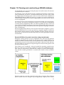
1
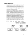
Table of Contents
I. Introduction........................................................................................................................1
1. About this tutorial....................................................................................................1
2. What is GRASS ? ......................................................................................................3
3. Credits........................................................................................................................5
II. Basics..................................................................................................................................7
4. Hardware and software requirements ..................................................................7
Hardware .............................................................................................................7
Basic Software .....................................................................................................7
Optional software ...............................................................................................7
5. Basic UNIX reference .............................................................................................11
6. Download and Install ............................................................................................13
Packages of GNU/Linux Distributions.........................................................13
Compilation of source code.............................................................................13
III. GRASS in 10 minutes - Quick Intro for Newbies .................................................15
7. How to Quickstart GRASS....................................................................................15
You have a GRASS database ...........................................................................15
You have a georeferenced data file, and know its geographical
coordinates ...............................................................................................16
You have a georeferenced raster file, but don’t know its geographical
coordinates ...............................................................................................16
You have a non-georeferenced data file ........................................................17
Other situations.................................................................................................17
8. The Most Important Commands to Get Started ................................................19
IV. GRASS Concepts..........................................................................................................21
9. GRASS structure.....................................................................................................21
10. GRASS commands ...............................................................................................23
11. Graphical User Interface .....................................................................................25
12. The GRASS Region ..............................................................................................27
What is the region.............................................................................................27
Why care about the region ..............................................................................27
How to work with the region .........................................................................27
How to change the default region..................................................................28
V. Start a Project..................................................................................................................31
13. Set-up your GRASS database .............................................................................31
14. Start running GRASS ...........................................................................................33
15. Planning and constructing a GRASS database ................................................35
General definition of a project area when using scanned maps ................35
Definition of a project area with predefined geographical resolution ......36
Definition of the project area without a previously defined resolution ...37
16. Set-up your location.............................................................................................39
17. Manage your data ................................................................................................43
VI. Import Data ...................................................................................................................45
18. Supported formats ...............................................................................................45
19. Raster Import ........................................................................................................47
20. Vector Import ........................................................................................................49
21. Sites (point data) import......................................................................................51
VII. Display and Query Maps ..........................................................................................53
22. Managing GRASS Monitors ...............................................................................53
Frames in monitors...........................................................................................53
23. Displaying Maps ..................................................................................................55
Colors .................................................................................................................55
Scripting the display of maps (and frames)..................................................55
24. Zooming and Panning.........................................................................................57
25. Adding Legends and Scales................................................................................59
26. Visualize in 3D with nviz ....................................................................................61
iii