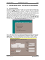
1
GEF/UNDP/IMO
GLOBAL BALLAST WATER MANAGEMENT PROGRAMME
BALLAST WATER RISK ASSESSMENT
(Activity 3.1)
USER GUIDE
(v1.4)
for the
BWRA Database/GIS System
BWRA USER MANUAL
Global Ballast Water Programme
Contents
PREFACE
SOFTWARE LICENCE REQUIREMENTS
The Global Ballast Water Management Programme (GloBallast Programme) is a cooperative
international initiative of the Global Environmental Facility (GEF), United Nations Development
Programme (UNDP) and International Maritime Organization (IMO). Legal use of the Ballast
Water Risk Asessment (BWRA) Database and associated software requires, at a minimum,
single-station licenced applications provided by licensed distributors of:
•
•
•
Microsoft’s Windows 2000, MS Access 2000 and MS Excel 7 (or higher versions).
ESRI’s ArcView 3.2
Primer-E Pty Ltd’s PRIMER v5.
Such licences have been obtained for Pilot Country participants of Activity 3.1 of the GloBallast
Programe, and have been licensed to either the IMO or specific Country Focal Points (CFPs)
upon written instructions of the IMO to URS Australia Pty Ltd and Meridian-GIS Pty Ltd.
COPYRIGHT AND PROPRIETARY RIGHTS
The Ballast Water Risk Assessment (BWRA) Database and associated interfaces, GIS maps
and User Guide have been developed by URS Australia Pty Ltd and Meridian-GIS Pty Ltd for
the specific purpose of BWRA training and evaluation by pilot country participants of Activity
3.1 of the GloBallast Programme, as administered by the IMO.
The proprietary rights to modify, make copies or otherwise distribute all or parts of the BWRA
Database or its associated interfaces, GIS maps and User Guide are vested with the IMO and
its Programme Coordination Unit (PCU), URS Australia Pty Ltd and Meridian-GIS Pty Ltd under
international copyright law and written contract.
Any person or organisation not directly associated with Activity 3.1 of the GloBallast
Programme who obtains a copy of the Database, its GIS interfaces, Maps or User Guide for
commercial research, commercial evaluation or commercial use without prior written
permission from the IMO ([email protected]) is liable to prosecution.
The IMO-PCU, URS Australia Pty Ltd and Meridian-GIS Pty Ltd uphold the right to modify the
BWRA software and User Guide without notice.
Global Ballast Water Programme
Programme Coordininating Unit
4 Albert Embankment
LONDON SE1 72R
United Kingdom
[email protected]
(contact re. administrative and
BWRA system licence queries)
URS Australia Pty Ltd
Level 3, 20 Terrace Road
EAST PERTH
Australia
WA 6004
[email protected]
(contact re. User Guide and
BWRA technical queries)
Meridian-GIS Pty Ltd
PO Box 295
WEST PERTH
Australia
WA 6872
[email protected]
(contact re. GIS queries)
INTERPRETATION AND APPLICATION OF BWRA OUTPUTS
The BWRA Database software has been developed to provide a ‘first-pass’ risk assessment for
training, demonstration and evaluation purposes. The accuracy and reliability of its output
depends heavily on the quality of data entered from ship’s Ballast Water Reporting Forms,
published and unpublished reports, and inputs from marine scientists. Responsibilty for
applying the BWRA database and/or its results for any ballast water management purpose by
a Pilot Country rests with the Country Focal Point (CFP) of that country.
December 2003 [v 1.4]
URS Meridian-GIS
BWRA USER MANUAL
Global Ballast Water Programme
Contents
Table of Contents
1.
INTRODUCTION .............................................................................................. 1
1.1
1.2
1.3
1.4
2.
BW REPORTING FORMS – DATA ENTRY AND MANAGEMENT ........... 5
2.1
2.2
2.3
2.4
2.5
2.6
3.
Calculation of C4 ....................................................................................... 40
Using the World Bioregions ........................................................................ 42
Adding and Editing the Risk Species Data .................................................... 42
RUNNING THE BW RISK ASSESSMENT .................................................. 45
7.1
7.2
7.3
7.4
7.5
7.6
8.
Overview of the C3 Coefficient ................................................................... 32
Collating the Port Environmental Data ......................................................... 33
Managing the Port Environmental Data with Excel........................................ 34
Using PRIMER for the Environmental Similarity Analysis (ESA) ..................... 35
RISK SPECIES COEFFICIENT (C4) ........................................................... 40
6.1
6.2
6.3
7.
BW Discharge Frequency (C1 Risk Coefficient)............................................. 28
BW Discharge Volume (C2 Risk Coefficient) ................................................. 29
Risk Reduction Factors (R1 and R2) ............................................................ 30
ENVIRONMENTAL MATCHING COEFFICIENT ....................................... 32
5.1
5.2
5.3
5.4
6.
GIS Scope and Technical Assistance ........................................................... 19
Developing the Port Map............................................................................ 19
Structure of the World Bioregions Map ........................................................ 23
Linking the ArcView GIS to the Access Database .......................................... 23
Displaying the BWRA Results...................................................................... 24
RISK COEFFICIENTS AND FACTORS FROM BWRF DATA .................. 28
4.1
4.2
4.3
5.
Database Overview ..................................................................................... 5
Checking and Avoiding Errors ....................................................................... 6
Mandatory Data Required by Database ......................................................... 7
Entering the Vessel Visit and Ballast Tank Information.................................... 9
Editing and Printing the Ship Visit Records................................................... 15
Database Management .............................................................................. 17
USING THE ARCVIEW GIS .......................................................................... 19
3.1
3.2
3.3
3.4
3.5
4.
BWRA System Overview............................................................................... 1
Rationale for ‘First-Pass’ Risk Assessments .................................................... 2
Importance of GIS Component ..................................................................... 3
System Development and Acknowledgements................................................ 4
Overview .................................................................................................. 45
Data Requirements for a Reliable Assessment.............................................. 45
Importing the Environmental Matching Coefficient (C3) ................................ 47
Reviewing and Changing the BWRA Formulae.............................................. 49
Displaying and Exporting the BWRA Results................................................. 51
Forward Risk Assessment........................................................................... 51
EVALUATING THE BWRA RESULTS .......................................................... 53
December 2003 [v 1.4]
URS Meridian-GIS
BWRA USER MANUAL
Global Ballast Water Programme
Contents
LIST OF APPENDICES
1
BW Risk Assessment Terminology and Methods
2
UN Country Codes
3
Use and Origin of the World Bioregions
4
Creating an ODBC Connection between Database and GIS
5
Glossary of Maritime Jargon and Ballasting Factors
6
IMO Ballast Water Reporting Form
December 2003 [v 1.4]
URS Meridian-GIS
BWRA USER MANUAL
Global Ballast Water Programme
1.
INTRODUCTION
1.1
BWRA SYSTEM OVERVIEW
Page 1
URS Australia Pty Ltd and Meridian-GIS Pty Ltd have produced this User Guide to help dataentry operators and managers use the computer system developed for the Ballast Water Risk
Assessment (BWRA) of the GEF-UNDP-IMO Global Ballast Water Programme (GloBallast
Activity 3.1; see http://globallast.imo.org/ for details and Pilot Country BWRA reports).
A major objective of Activity 3.1 was to provide, for each Demonstration Site, a user-friendly
Database-GIS system that can manage and integrate key shipping, environmental and risk
species data for undertaking ‘first-pass’ risk assessments.
The BWRA Database is operated by MS Access 2000 and allows users to:
(1)
Store, edit and manage all data recorded on IMO BW Reporting Forms (Task 5 of
BWRA Activity 3.1).
(2)
List all source ports from which BW is imported by the demonstration site and tabulate
the frequencies and amounts of ballast water discharged from each these ports (Tasks
2 and 3 of BWRA Activity);
(3)
Interact with Excel and PRIMER applications for calculating, storing and using results
from multivariate environmental similarity analysis (Task 6 of BWRA Activity).
(4)
Store and edit the types, regional locations and status information of risk species which
have been transferred between ports by ships’ ballast water and other vectors (Task 8
of BWRA Activity).
(5)
Undertake ‘first-pass’ risk assessments using a semi-quantitative method that
minimises subjective input1 (Task 9 of BWRA Activity).
The graphical information system (GIS) is operated by ArcView 3.2, and allows users to:
(6)
Map and display all coastal and marine resources (biological, social/cultural and
commercial) in and around the demonstration port that might be impacted by
introduced marine species (Task 1 of BWRA Activity).
(7)
Map and display the de-ballasting and ballasting patterns in and around the
demonstration port including locations, frequencies and volumes of ballast water
discharges and uptakes (Task 2 of BWRA Activity).
(8)
Display, in a convenient colour-graphic style, the:
(a) location of all source ports from which BW is imported (Task 3 of BWRA Activity);
(b) location and frequency of departures to all potential ‘destination ports’ (= next
ports of call) to which ballast water is exported (Tasks 4, 11 of BWRA Activity);
(c) environmental similarity between the demonstration port and its various source
and destination ports (Task 7 of BWRA Activity);
1
see Appendix 1 for a summary description of qualitative, semi-quantitative and quantitative methods
of risk assessment.
December 2003 [v 1.4]
URS Meridian-GIS
BWRA USER MANUAL
Global Ballast Water Programme
Page 2
(d) the types of risk species present at the source ports and demonstration port that
might be introduced either to the demonstration site or exported to its destination
ports, respectively (Task 8 of BWRA Activity); and
(e) the five levels of relative risk (= very low, low, moderate, high, very high) posed
by each source port for the introduction of unwanted species to the demonstration
site, based on its present pattern of trade (Tasks 9 and 11 of BWRA Activity).
This User Guide also explains how to perform the multivariate environmental similarity analysis
(Task 6 of the BWRA Activity) using the PRIMER statistical package. The following graphic
shows the complete BWRA computer system described in this User Guide:
Schematic of the GloBallast BWRA System
Computer
Records / Raw Data
Demonstration Site
shipping records and
BW Reporting Forms
Port environmental
parameters
Results / Outputs
MS Access
Vessel, port and
ballast water
tables
GUI
Results Tables
(o printter orexport)
- Vessel visit summaries
- Ballast water summaries
- Risk species summaries
- Risk coefficients*
PRIMER 5
Multivariate
similarity analysis
Risk
coefficient
tables
Risk species taxonomic
and distribution data
-
ESRI ArcView GIS
Port charts, maps &
resource data
GUI = Graphic User Interface
1.2
GUI
GUI
Map files
Demo Site Port Map
Bathymetry, navigation
Infrastructure, habitats
Resources, etc.
Ballast/deballast pattern
-
World Map
Bioregions
Source ports
Destination ports
Risk species lists
Risk coefficients*
*for Demonstration Site relative to each source and destination port
RATIONALE FOR ‘FIRST-PASS’ RISK ASSESSMENTS
Current IMO BW management guidelines provide port states significant flexibility in
determining the nature and extent of their national BW management regimes. This flexibility
is warranted given that nations are still experimenting with different approaches. Thus a port
state may wish to apply its management regime uniformly to all vessels arriving with ballast
water, or it may wish to apply a more selective regime by attempting to identify those trading
routes and/or vessels which have a significant chance of introducing unwanted aquatic
species.
The uniform approach offers the advantage of a simple programme administration, in that
there are no judgements to be made (or justified) by the port state regarding which vessels
must participate.
It also requires minimal information management and offers more
protection from unexpected, novel invaders. The primary disadvantages of the uniform
approach are:
(1)
it causes considerable costs to vessels which otherwise might not need to take action;
December 2003 [v 1.4]
URS Meridian-GIS
BWRA USER MANUAL
(2)
Global Ballast Water Programme
Page 3
because all vessels are involved in undertaking the required BW control measures,
compliance monitoring costs by the port state will be high and inordinate berthing and
cargo loading delays may be experienced.
A selective (risk management) approach can reduce the number of ships subject to ballast
water controls and compliance monitoring, and is also attractive to nations that wish to avoid
introductions of particular harmful species, such as toxic dinoflagellates. If fewer restrictions
are placed on ‘low risk’ vessels, then more time and funds will be available for applying more
rigorous measures on ships deemed as ‘high risk’. The disadvantages of the selective
approach are:
(1)
it requires the port state to implement an information management system whose
effectiveness depends on the quality of the supporting information, computer systems
and management infrastructure;
(2)
it requires an organized, defensible means of evaluating the risk posed by each route
or vessel.
(3)
it may leave the port state more vulnerable to introduction risks from non-targeted or
unknown species.
To help the pilot countries evaluate the choice of adopting either a uniform or selective
approach, the GloBallast Programme included a ‘first-past’ BWRA for their demonstration sites
(Activity 3.1). The assessment undertaken for each of these sites used the same AccessArcView system described in this User Guide. The system allows operators to identify shipping
arrival patterns and sources of ‘imported’ ballast water (Section 4), and gives an indication of
the relative risk posed by each trading route by integrating this information with source
port/demonstration site environmental similarity (Section 5) and the regional locations of risk
species (Section 6).
1.3
IMPORTANCE OF GIS COMPONENT
The GIS component is invaluable for graphically displaying key information and results, in a
user-friendly and interactive fashion, using its Port and World maps. It is possible to collate all
the shipping, environmental and species data and calculate the first-pass risk assessments
without installing or using the ArcView GIS. However, checking and interpreting the results in
the large output tables produced by the Access database is difficult and time-consuming.
Displaying results with ArcView GIS helps results checking and evaluation, and it provides
convenient graphic outputs for BWRA demonstrations and training.
It is also possible to link the outputs from the Access database to other GIS packages, such as
ArcInfo or MapInfo. However, the ESRI ArcView 3.2 has been used for the following reasons:
•
it is an affordable, widely used, well-tested and stable platform for the Windows
operating system.
•
it remains a de facto industry standard for GIS tasks that is well supported by ESRI and
the global user community (various types of geographic files and data produced by
ERSRI and ArcView users are easy to acquire from the web and share).
•
there is excellent product and ‘distance’ support, including a wide variety of help and
training resources on the internet.
•
it is easy to customise its user interface and tailor its functionality, therefore permitting
an uncluttered application that facilitates BWRA training, use and demonstration.
December 2003 [v 1.4]
URS Meridian-GIS
BWRA USER MANUAL
1.4
Global Ballast Water Programme
Page 4
SYSTEM DEVELOPMENT AND ACKNOWLEDGEMENTS
The system was developed by the following team at URS Australia Pty Ltd and Meridian-GIS Pty
Ltd:
Dr Rob Hilliard (Tteam leader, and calculation and treatment of risk coefficients)
Mr Chris Clarke (BWRA Database/GIS integration and GIS interfaces)
Mr Christopher Stevens (BWRA Database customisation and Graphic User Interfaces)
Mr John Polglaze and Cmdr Terry Hayes (BW Reporting Form – BWRA Database compatibility)
The following people assisted with ‘hands-on’ evaluations of various components of the
developmental versions, and are thanked for their useful suggestions and information inputs:
Dr Boris Alexandrov, Institute of Biology of Southern Seas [Odessa Branch], Ukraine National
Academy of Science, Odessa, Ukraine.
Dr AC Anil, National Institute of Oceanography, Dona Paula, Goa, India.
Mr Roman Bashtannyy, Shipping Safety Inspectorate, Ministry of Transport, Odessa, Ukraine.
Ms Letitia Greyling, National Ports Authority, Johannesburg, South Africa.
Mr Rob Healy, Meridian-GIS Pty Ltd, Perth, Australia.
Dr Andréa de O.R. Junqueira, Instituto de Biologia, Universidade Federal do Rio de Janeiro, Brazil.
Mr Victor Khmelevskiy, Sea Commercial Port of Odessa, Odessa, Ukraine.
Mr Daniel Lins Menucci , Agência Nacional de Vigilância Sanitária, Gerência Geral de Portos e
Fronteiras, Brasilia.
Mr Alexandre de C. L. Neto, Programa GloBallast, Diretoria Portas e Costas, Rio de Janeiro, Brazil.
Dr Nikolay E. Pavlenko, Institute of Transport Medicine, Odessa, Ukraine.
Mr Naseer Kayvan Rad, Ports & Shipping Organisation, Tehran, IR Iran.
Mr Liu Yan, Maritime Safety Administration [Liaoning Province], Dalian, PR China.
The base layer of the World Bioregion Map and advice on risk coefficient options was kindly
provided by Dr Chad Hewitt, CSIRO Marine Research (now at Marine Biosecurity, Ministry of
Fisheries, Wellington, New Zealand) The following are also thanked for their review and
improvements to the World Bioregion Map and/or provision of risk species information:
Mr Adnan Awad, GloBallast Programme, Cape Town, South Africa.
Dr Marnie Campbell, Campbell & Associates, Perth, Western Australia.
Dr Steve Coles, Bishop Museum, Honulu, Hawaii, US.
Dr Flavio Fernandes, Instituto de Estudos do Mar Almirante P-Moreira, Arraial do Cabo, Brazil.
Dr Luciano Felício Fernandes, Universidade Federal do Paraná, Brazil.
Dr Gustaaf Hallegraeff, University of Tasmania, Hobat, Australia.
Dr Pat Hutchings, Australian Museum, Sydney, Australia.
Dr Di Jones, Western Australian Museum, Perth, Australia.
Dr John Lewis, Defence Science and Technology Organisation, Melbourne, Australia.
Dr Wang Lijun and Mr Jiang Yuewen, National Marine Environment Protection & Monitoring Centre,
State Administration of Oceanography, Dalian, China.
Dr Barry Russell, Museum of the Northern Territory, Darwin, Australia.
Dr S Sawant, National Institute of Oceanography, Dona Paula, Goa, India.
Dr Fred Wells, Western Australian Museum, Perth, Australia.
Dr Vahid Yavari, University of Ahvaz, Ahvaz, IR Iran.
Professor Y. Zaitsev, Institute of Biology of Southern Seas [Odessa Branch], Ukraine National
Academy of Science, Odessa, Ukraine.
December 2003 [v 1.4]
URS Meridian-GIS
BWRA USER MANUAL
Global Ballast Water Programme
Page 5
2.
BW REPORTING FORMS – DATA ENTRY AND MANAGEMENT
2.1
DATABASE OVERVIEW
The Database can store all information provided in all cells of the standard IMO Ballast Water
Reporting Form (BWRF; Appendix 6). Entering and saving the data from a single BWRF
creates a new ‘Ship Visit Record’ in the Database. The Database also allows the Deadweight
tonnage (DWT) and berth of the visiting ship to be part of this record (this information is not
requested in the present IMO BWRF, although the ‘Discharge Location’ cell of this form can be
used to record which terminal or berth the ship intends discharging BW; Appendix 6).
The graphic user interfaces (GUIs or ‘windows’) for adding and for editing or printing the ship
visit data are similar. The data input window is opened by clicking the ‘Add New Ship Visit
Record’ button on the main menu. To locate a previously saved Ship Visit Record (for editing
or printing), click on the ‘Edit/Print Ship Visit Records’ button in the main menu.
Both the ‘Add’ and the ‘Edit/Print’ Ship Visit Record windows have three ‘tabs’ which open subwindows (the tabs are labelled ‘Vessel Information’, ‘Ballast Water Tanks’ and ‘Ballast
Water History’). The three sub-windows follow the same structure of the IMO standard
BWRF (Appendix 6). This allows the BWRF data to be entered and/or edited conveniently.
December 2003 [v 1.4]
URS Meridian-GIS
BWRA USER MANUAL
Global Ballast Water Programme
Page 6
It is important to recognise that some BWRFs issued by Port States or used by shipping
companies may not be exact replicas of the IMO BWRF. These forms may contain a different
number of questions, and/or the questions may be located on different places on the form.
Extra care is required when entering data from different types of BWRFs, to ensure the
information is entered into the correct data entry-field of the Input interface.
2.2
CHECKING AND AVOIDING ERRORS
BWRFs handed to Port Officers without any checking system are very likely to be incomplete
and/or contain errors. These errors usually represent mistakes or misunderstandings by the
ship’s officer or agent when filling out the form. Data-Entry Operators need to use their
experience and judgement when entering BWRF records, and must not enter information into
the Database if it is clearly wrong or illogical. There are four types of errors:
(a) Missing information (empty cells on the BWRF);
(b) Illegible (unreadable) and misspelled information (e.g. from a poor photocopy, fax or
bad writing, misspelled port or ship names);
(c) Factual mistakes in the BWRF data (including illogical dates, conflicting BW volumes,
BW tank numbers, etc); and
(d) Transcription errors made by the Data-Entry Operator (when entering or editing the
BWRF data).
(a, b) Missing and Unreadable Information
These errors are common and will always occur unless adequate BWRF checking procedures
have been implemented at the Receiving Port. Much of the critical information about a
particular ship can be found or checked if the Data-Entry Operator has access to a recent
Lloyds Ship-Finder CD (as provided by the GloBallast PCU to the Demonstration Sites).
International Port Guides (e.g. the Fairplay Ports Guide CD or hard cover directory) are also
invaluable for checking the correct spelling of source port and destination port names, their
UN port codes and geographic coordinates (all of which are used by the Database).
Where the BW discharge volume is missing, unreadable or illogical, an Excel file is available in
the Utilities Folder (Estimating BW discharges from port records.xls) for estimating
typical discharge volumes for different vessel types, based on their deadweight tonnage
(DWT) and cargo-loading/unloading behaviour. DWTs can be found in the Lloyds Ship-Finder
CD for all listed ships.
(c) Factual and Logical Errors
These BWRF errors typically comprise conflicting information with respect to the:
-
Logical sequence of BW Source, Exchange, Ship Arrival and Intended Discharge dates;
-
Number of Ballast tanks containing BW (versus the ship’s Total Number of BW Tanks);
-
Ballast Tank volumes declared for intended discharge, versus the ship’s Total BW
Capacity, its DWT and its cargo-loading requirement at the Receiving Port.
Care is needed to interpret and enter all dates correctly. For example, “01-02-03” could be
01-Feb-2003, or 02-Jan-2003, or 03-Feb-2001, depending on the date format system (i.e.
typical European, American and Asian respectively). It is therefore important to check if all
dates written on any BWRF conform with the Database’s fixed dd/mmm/yyyy format.
December 2003 [v 1.4]
URS Meridian-GIS
BWRA USER MANUAL
Global Ballast Water Programme
Page 7
Apart from checking the dates on a BWRF, Data-Entry Operators must also check the logical
sequence of the BW source date, BW exchange date, the ship arrival date and the intended
(or known) BW discharge date. It is obviously impossible for a ship to arrive or discharge its
BW before it has taken it up, or made an exchange. For example, if the BW tank exchange
date/s are recorded on the BWRF, these must be after the BW source date (date of uptake)
and before the ship’s arrival date and BW discharge date.
Data-Entry Operators must be alert for these surprisingly common errors, which are often
caused by haste, unfamiliarity and confusion when a ship’s officer is completing the BWRF.
Dates recorded on the BWRF for the BW uptake (and subsequent possible BW exchange at
sea) must also be consistent with the duration of the ship’s voyage from the BW source port
to the Arrival Port, and the size and number of filled BW tanks. Data-Entry Operators should
remember that even small ships require 18 hours or more to complete a BW exchange of all
tanks. For large bulk carriers and crude carriers that use the x3 ‘flow-through’ method, a
complete BW exchange can take 4-6 days or more, depending on weather and sea state.
(d) Transcription Errors
These errors can be made by the Date-Entry Operator when entering the data, including
accidental mis-typing (‘typos’). Transcription errors include the Data-Entry Operator
misunderstanding the ‘day-month-year’ sequence (date format) in the dates on the BWRF.
The date format used by a ship’s officer may not be same as the fixed format used by the
BWRA Database (dd/mmm/yyyyy; see Section 2.4). Date formats on BWRFs will vary
according to the origin and training of ship’s officers, and may be ambiguous. For example, a
date may be written as “mm/dd/yy” (e.g. by North American officers), “yy/mm/dd” (e.g. by
Chinese, Korean or Japanese officers), or “dd/mm/yy” (e.g. by officers from European and
Commonwealth countries).
If any piece of BWRF information is illogical or highly questionable, but cannot be checked or
corrected from other data sources, it is better not to enter it (especially if the information is
not a Mandatory item; see Section 2.3).
Most GloBallast Pilot Countries began implementing a BWRF checking system to reduce the
incidence of incomplete/incorrect forms during Activity 3.1. While future BWRFs should be
more complete and have fewer mistakes, Data-Entry Operators should maintain the habit of
carefully examining every BWRF before starting to enter its data into the Database. To help
Data-Entry Operators understand English phrases commonly used in shipping and ballasting
requirements, Appendix 5 contains a glossary of ‘Maritime Jargon’, including the factors which
influence the timing and volumes of BW discharges.
2.3
MANDATORY DATA REQUIRED BY DATABASE
Not all of the data-entry fields need be completed in order for the Risk Assessment to
function. However some data-entry fields are Mandatory, and the Database will not allow a
new Visit Record to be saved until these fields are entered. The following mandatory fields
are labelled in red text on the ‘Add’ and ‘Edit/Print’ Visit Record windows:
• IMO Number
• Arrival Date
• Tank Code
• Tank Volume
December 2003 [v 1.4]
URS Meridian-GIS
BWRA USER MANUAL
Global Ballast Water Programme
Page 8
The IMO number is the unique 7 digit identifier of the vessel. This ID number remains the
same for the whole life of the ship, irrespective of any changes to its name. Other fields
which should be completed are the ‘Arrival Port’ (in the ‘Vessel Information’ sub-window)
and the unit of discharged BW ( in ‘Specify units’ in the ‘Ballast Water Tanks’ sub-window):
The unit of BW discharge is recorded on the IMO BWRF, and is specificed for each ship visit
record by selecting from the drop-down list either m3 (cubic metres), MT (metric tonnes), LT
(long tons) or ST (short tons; see Section 2.4.6 and Appendix 5). Until a unit is selected, the
other data-entry fields for ‘Total Ballast Water On Board’ and ‘Total Ballast Water Capacity’ will
remain unavailable in the ‘Ballast Water Tanks’ sub-window. If no unit is present on the
BWRF, select MT as the default unit (this is the most common unit used by ships).
The Database will not save a Ship Visit Record until all Mandatory fields have been
completed and the ‘Save Visit Details’ button is clicked (at bottom right of the ‘Ballast
Water History’ subwindow):
December 2003 [v 1.4]
URS Meridian-GIS
BWRA USER MANUAL
Global Ballast Water Programme
Page 9
Similarly, no BallastTank details will be saved unless the ‘Save Tank Details’ button is
clicked. This button is located in the bottom right corner of the ‘Add Tank’ sub-window):
2.4
ENTERING THE VESSEL VISIT AND TANK INFORMATION
2.4.1 IMO Number and Vessel Name
•
Always check and enter the ship’s unique IMO Number first. This mandatory ship
identifier is used by the Database to identify all Visit Records. The ship’s IMO Number
may already be present in the drop-down list.
•
If the ship is already on the Database, its IMO Number should be selected from the dropdown list. This will cause the ship’s Name, Type, DWT, Owner, GT, Flag and Call Sign to
automatically appear in the respective data-entry fields.
•
If the IMO Number is not present or appears incorrect on the BWRF (e.g. not 7 digits),
use the Vessel Name or its Call Sign to obtain or confirm the IMO Number from the
Lloyd’s Ship-Finder CD. The Lloyd’s Ship-Finder also lists other valuable information
including shipType, GT and DWT.
If the IMO number is not in the drop-down list, then click on the ‘Add New Vessel…’ button
(in the ‘Vessel Information’ subwindow) to enter the new ship information in the cells of
the ‘Add Vessel’ subwindow. Use the Lloyd’s Ship-Finder to check and fill any data gaps:
December 2003 [v 1.4]
URS Meridian-GIS
BWRA USER MANUAL
Global Ballast Water Programme
Page 10
Be careful with the vessel’s name spelling, especially on hastily written BWRFs. For example,
the correct, official name of ‘Tokyo Maru II’ may be ‘Tokyo Maru 11’, ‘Tokyo Maru No. 11’, or
‘Tokyo Maru No. 2’). Similarly, the correct name of the tanker ‘MT Tokyo Maru’ is probably
‘Tokyo Maru’. This is because ‘MT’ means ‘motor tanker’ and is not part of the ship’s
registered name. Similar abbreviations include ‘MV’ (motor vessel), ‘SS’ (steam ship), ‘RV’
(research vessel), etc. In the case of company names or initials (e.g. OCL Pacific Trader, NYK
Pacific Trader, Evergreen Pacific Trader etc), sometimes they are part of the official name in
Lloyds’ Ship-Finder, sometimes they are not.
Be aware that ships often change their name, radio call sign, flag, owner or local agent. This
does not matter for the Database, provided the IMO Number matches the basic ship details in
the Lloyd’s Ship-Finder (i.e. Vessel Type, GT and DWT). If a ship changes its name after a
previous visit and Database entry, there is an ‘Edit Vessel’ feature for updating its details
such as a new Name, Call Sign, Flag, Owner, Agent, etc (see Section 2.5).
2.4.2 Vessel Type
•
To allow the Database to generate accurate reports for particular Vessel Types, the exact
spelling of Vessel Type must conform to one of the following labels used by the Database:
Bulk Carrier
Oil/Bulk Ore Carrier (‘OBO’ and ‘O/O’)
Bulk/Container carrier
Chemical Tanker
Container Ship
Chemical/Products Tanker
General Cargo Ship
Crude Oil Tanker
Reefer (Refrigerated Cargo Ship)
Products Tanker
Ro-Ro Cargo Ship
Gas Tanker (incl. LPG, LNG, etc)
Vehicles Carrier
Passenger Ship (includes ferries, liners)
Other (for miscellaneous types)
Passenger/Ro-Ro Cargo Ship (includes
Tanker (for multipurpose/unclassed types)
many roll-on/roll-off ferries)
•
Spelling mistakes will accidentally create a ‘new’ and uneccessary Vessel Type (e.g. typing
in ‘Product Tanker’ will generate a new vessel type, as it is different from ‘Products
Tanker’). To avoid this error, always use the drop-down list to select the Vessel Type,
unless it is actually a new vessel type which is making frequent visits to the Receiving Port
(infrequent and miscellaneous vessel types such as a Research Ship or a Dredge should be
classified as ‘Other’).
This tip applies to all data-fields which have drop-down lists, such as Country, Port, IMO
Number, Vessel Name, Owner, Agent etc.
When using the Database to review Vessel Types or allocate them to particular berths and
terminals within the Arrival Port, be aware that many of the smaller ‘general cargo ships’ and
‘bulk carriers’ (<15,000 GT) can trade both general cargo and bulk cargo. Many general cargo
ships also carry containers which can be worked by their own deck gear or by wharf cranes.
2.4.3 Other Vessel Information
•
The ship’s Name, Flag, Owner, Port and Country should be entered with initial Capital
Letter, followed by lower case.
•
All of the Call Sign should be entered with UPPERCASE letters.
•
As with all dates in the Database, the mandatory arrival ‘Date (dd/mmm/yyyy)’ has to
be entered in this format (i.e. ‘21-01-03’ must be entered as “21/Jan/2003”).
December 2003 [v 1.4]
URS Meridian-GIS
BWRA USER MANUAL
•
Global Ballast Water Programme
Page 11
Remember that date formats used by ship’s officers may be different, and these require
careful interpretation (see Section 2.2 for details).
The ‘Last Visit’ button (in the Vessel Information sub-window) accelerates the data entry
task. The ‘Last Visit’ will display all information concerning the last visit made by the
selected ship to the Arrival Port. This is very useful for ships which make regular port visits on
scheduled services (for example Odessa - Bourgas, Khark Island - Ain Sukhna, Dalian - Pusan,
Mumbai - Colombo, Saldhana Bay - Rotterdam, Sepetiba - Taranto, etc).
2.4.4 Port Information
•
Ensure that the ‘Arrival Port’ name is correct and is ticked in the ‘Set as default’ tick
box. This saves time as well as ensuring the Database will use the Visit Record. If this
box is not ticked, the Visit Record will not be included in the Database risk calculations.
•
Similiarly, the name of the Berth should be selected only from the berth or terminal
names already used by the ArcView GIS Port Map. These names will be available for
quick selection in the drop-down box.
NOTE: Although ‘Berth’ is not specifically requested in the IMO BWRF, it asks for the location of
the BW discharge. A Receiving Port can request all ships to enter the number or name of their
planned berth, terminal or anchorage as the Discharge Location (plus a ‘Lat-Long’ position if a
discharge is to be made in the port’s approach channel or in an emergency anchorage, etc).
2.4.5 Last Port, Next Port and Add New Port
•
A large number of ports and associated details are already present in the Database, and
these can be quickly selected by using the ‘Country’ then ‘Port’ drop-down lists.
•
If the name of the Last Port or Next Port was not written on the BWRF, but the next or
last Country is present, then only Country name may be entered by going to the Port
drop-down box for that Country and selecting ‘Not Reported’ (at top of Port list).
•
If the Country of the missing Last Port or Next Port is also absent on the BWRF, then ‘Not
Reported’ needs to be selected from the Country drop-down menu (at top of Country
list). Visit Records that have a ‘Not Reported’ Last Port will not be listed in the risk
calculation outputs, but they will be used by the Database for compiling accurate statistics
and reports about the Receiving Port’s vessel visits, etc.
•
Some Country and Port names may appear to be absent from the Drop-down lists
because of different spellings. Data-Entry Operators need to understand that some
Country names may be spelled in English or in the language of that country (e.g. ‘Spain’
= ‘Espagna’; ‘Ivory Coast’ = ‘Cote D’Ivoire’).
•
Similarly, the port of ‘Vlissingen’ in the Netherlands may be written on a BWRF as
‘Flushing’ (which is not the official name). Therefore Data-Entry Operators should refer to
an international Port Guide before entering the name and details of any new port.
•
Another problem is that a port name hastily written on a BWRF may actually refer to two
or more different ports, sometimes within the same country! For example, ‘Tenerife’ on
a BWRF may refer to the famous port of ‘Tenerife’ in Spain’s Canary Islands, or to the
busy bulk import port of ‘Santa Cruz de Tenerife’, which is also in Spain.
•
Many Middle East ports have an official prefix (typically ‘Al’ or ‘El’) which is not added to
the BWRF, while others are provided an unofficial prefix on the BWRF. Therefore the
names of some Middle East ports may appear to be ‘missing’ from the Database. To
December 2003 [v 1.4]
URS Meridian-GIS
BWRA USER MANUAL
Global Ballast Water Programme
Page 12
confirm if the port is already present on the Database, Data-Entry Operators should
quickly check for the ‘Al’, ‘El’ or no prefix spelling in the Port drop-down list.
•
Port name errors are caused by haste, laziness or ignorance of ships’ officers when
writing the BWRF. The vessel type, size and last/next ports of call (plus its history of
previous visits on the Database) should alert the Data-Entry Operator to this problem.
•
Before adding a new port to the Database, it is important to use a recent international
Port Guide publication (e.g. Fairplay Ports Guide CD) to check the ‘new’ port is not:
- the name of a terminal or ‘sub-port’ within a larger port (e.g. Hansaport is a subport of Hamburg, Europoort is the big container terminal at Rotterdam);
- the name of a town or city beside an existing port which has a different name;
- lacking an official prefix such as ‘Al’ (or was given an unofficial prefix); and/or
- is mispelled (this is common for many Japanese, Korean and Chinese ports).
In China, ‘Zhousan’ and ‘Dinghai’ refer to the same port, as do ‘Yantai’ and ‘Muping’, and
‘Xiamen’ and ’Weitou’. The City State of Singapore has several ports, one of which is
called Singapore (i.e. Singapore Singapore, as well as Singapore Jurong, Singapore
Keppel, Singapore Semawang, etc). For confusing Japanese or Chinese port names, use
the port’s Prefecture Name (the second name after the port name in the Database) and
the UN Port Codes to help confirm the correct port name and spelling.
•
All ports in the Database have a unique, five letter UN Port Code. The first two letters
denote the Country (prefix codes of most countries are in Appendix 2). The last three
letters identify the port in that country. For example, Saldanha Bay in South Africa is
ZASDB and Cape Town is ZACPT. For the port of Mumbai in India (previously known as
Bombay), its code is INBOM, while Dalian is CNDLC and Sepetiba is BRSPB.
•
All ports in the Database already have their five letter code. As with the IMO Number, the
Database uses the unique UN Port Codes to ensure all data are managed correctly for the
risk calculations.
•
To Add and Save a New Port, the Data-Entry Operator must confirm the correct spelling
of its Country, Name, UN Port Code and obtain its Latitude/Longitude and Bioregion,
before clicking on the ‘Add New Port…’ button to add these details.
•
Apart from a port’s Bioregion, all port details can be obtained from publications such as
the Fairplay Port Guide CD.
•
All Bioregions in the GIS World Map (Section 3) are already listed in the drop-down list
inside the ‘Add New Port’ subwindow. Use the World Map to find the correct Bioregion. A
copy of this map is in a zoomable Adobe file of the Utilities Folder (Bioregions.pdf),
as well as on the ArcView GIS (Section 3).
•
Not every port in the world has been assigned a UN Port Code, including many domestic
ports in China. For ports without a UN Port Code, the first three letters of the port’s name
may be added behind the two letters of its Country code prefix (Appendix 2) to form a
unique port code. If the grouping of letters is already used for another port, the Database
will not accept it. In this case, the 3rd, 4th or 5th letter of the new code can be altered to
make a unique combination that the Database will accept. Alternatively, numbers can be
used (e.g. CN008 for a small port in China).
•
As with all latitude/longitude entries to the Database, the port’s latitude and longitude
should be entered in the Decimal Degree format (i.e. not as Degrees, Minutes,
Seconds). Latitudes South and Longitudes West are entered as negatives (e.g. -30.25).
December 2003 [v 1.4]
URS Meridian-GIS
BWRA USER MANUAL
•
Global Ballast Water Programme
Page 13
Lat/Long minutes (‘) and seconds (“) need to be converted to Decimal Degrees before
adding to the whole degree number. The full conversion can be done automatically using
the Excel PED File (see Section 5.3), or by refering to a simple conversion table such as:
Minutes
01
02
03
04
05
06
07
08
09
10
11
12
13
14
15
Decimal
0.02
0.03
0.05
0.07
0.08
0.10
0.12
0.13
0.15
0.17
0.18
0.20
0.22
0.23
0.25
Minutes
16
17
18
19
20
21
22
23
24
25
26
27
28
29
30
Decimal
0.27
0.28
0.30
0.32
0.33
0.35
0.37
0.38
0.40
0.42
0.43
0.45
0.47
0.48
0.50
Minutes
31
32
33
34
35
36
37
38
39
40
41
42
43
44
45
Decimal
0.52
0.53
0.55
0.57
0.58
0.60
0.62
0.63
0.65
0.67
0.68
0.70
0.72
0.73
0.75
Minutes
46
47
48
49
50
51
52
53
54
55
56
57
58
59
60
Decimal
0.77
0.78
0.80
0.82
0.83
0.85
0.87
0.88
0.90
0.92
0.93
0.95
0.97
0.98
1.00
Coordinates South of Equator and West of the 0o Meridian require the minus sign (-) prefix
2.4.6 Entering data into the ‘Ballast Water Tanks’ sub-window
•
Specifying the Units of BW volume must be completed for each ship Visit Record (select
MT as the default value if the Unit is missing from the BWRF).
•
Units of BW volume are typically MT (metric tonnes), m3 (cubic metres), Long Tons
(2200 pounds) or Short Tons (2000 pounds), all of which are available in the drop-down
list. They are roughly equivalent (see Appendix 5).
•
Always check for inconsistencies between the ‘Total Number of BW Tanks’, the ‘Number of
Tanks in ballast’, the ‘Numberof Tanks not in ballast’ and the ‘Total Number of Tanks
Exchanged’. These numbers should form a logical relationship.
•
Similarly, ‘Total BW On Board’ should never exceed ‘Total BW Capacity’.
•
If the BW exchange data have been completed incorrectly, it is not necessary to obtain the
correct information because the BW exchange details are not used by the ‘first-pass’ BWRA
calculations (Section 4.1).
•
Other data-entry fields in the ‘Ballast Water Tanks’ window are not critical to the Risk
Assessment calculations, but can be entered to provide a complete database to permit
other reviews, data export/analysis and reporting requirements.
2.4.7 Entering data into the ‘Ballast Water History’ sub-window
The reported BW discharge volume, source port/s, and the source, arrival and discharge dates
must all be logical with respect to the duration of the voyage, the vessel’s type and cargo
loading pattern, its size (DWT) and its ballast water capacity (see Section 2.2). Common
errors on BWRFs include:
•
Inconsistencies between the dates of ballast water uptake, exchange and discharge.
December 2003 [v 1.4]
URS Meridian-GIS
BWRA USER MANUAL
Global Ballast Water Programme
Page 14
It is impossible for a ship to discharge ballast water before it has taken it up. However
Data-Entry Operators must alert for this surprisingly common error, probably caused by
haste or confusion by ship’s officer with the form. Also, if a BW exchange has been
reported, then the date/s of this exchange must logically be after the date of uptake, and
before the dates of arrival and subsequent discharge.
•
The date/s recorded on the BWRF for the BW uptake (and possible BW exchange) must
be consistent with the voyage time from the BW source location to the arrival port.
•
Latitude/longitude positions for the BW source and discharge locations are only required if
these operations were not conducted in the usual port locations (the Database and GIS
use and display only pre-determined discharge locations such as berths, terminals,
anchorages; see Section 3).
•
Latitude/longitude positions are usually provided for the voyage sector where BW was
reported to be exchanged. Data-Entry Operators need to remember that even small ships
may require 24 hours to complete a ~95% BW exchange for all tanks. For large bulk
carriers and crude carriers which use the x3 ‘flow-through’ method, a complete exchange
often requires 4-6 days (or more if bad weather and seas interrupt the exchange).
•
The reported method of BW exchange should be recorded in the Database. If an exchange
is reported but no method was recorded on the BWRF, use the ‘Not Specified’ option (in
the drop-down window for BW Exchange Method).
•
‘Sea height’ refers to the height of waves and swells at the time of the reported BW
exchange. ‘Sea height’ is typically between 0 and 6 metres (maybe up to 20 metres for a
severe winter storm or cyclone, which ships always try to avoid). Anything greater than 10
metres on the BWRF very probably represents a mistake or misunderstanding, and large
values should not be entered. High seas and rough weather provide a genuine reason for
a ship not exchanging ballast en route. However it is common for a Ship’s officer to think
that ‘Sea height’ refers to water depth at the time of the exchange, and not to the wave
height.
•
Sea temperature values, if present, should lie between –1ºC (minimum) to about 32ºC
(maximum).
•
Check that all BW discharges recorded on the BWRF are actually for the correct arrival port
(i.e. the port where the ship submits the BWRF). For example, if a ship arrives at Sepetiba
and submits a BWRF that includes tank/s discharges at the port of Santos, these discharge
volumes should not be entered into the Sepetiba Database.
•
Salinity units are usually recorded as ‘SG’ (Specific Gravity; often 1.025 for coastal port
waters). The units may be ‘g/L’ (about 35 g/L for typical ocean water), or ‘µS/cm’. After a
salinity unit has been entered to the database the first time, it will always appear in the
drop-down list. The ‘first-pass’ BWRA does not use salinity in the calculations (Section 4.1).
After the BW History details for the first Tank have been entered for a particular Visit, entering
data for the subsequent tanks can be accelerated by clicking on the ‘Add Previous Tank
Details’ button. This will populate the new tank sheet with the same details, and the operator
can quickly change minor details (such as tank name, BW source, source date, BW volume,
exchange details). This removes the need to re-enter the same information for every tank.
2.4.8 Bunkering and Part-Loading Cargos
When interpreting BWRFs, it is important to remember that port and BW details may be
influenced by previous ‘temporary’ port calls to obtain fuel, change crews or part-load a cargo.
December 2003 [v 1.4]
URS Meridian-GIS
BWRA USER MANUAL
Global Ballast Water Programme
Page 15
•
BWRFs for crude oil tankers operating to the ROPME Sea Area commonly present this ‘last
port of call’ ≠ ‘BW source port’ problem. Many tankers, including VLCCs and ULCCs
(Appendix 5) often stop at Fujairah or Khor Fakkan for bunkering, stores and/or a crew
change, usually on their inbound voyage but sometimes on their outbound voyage. The
BWRF entries for “last port” and “next port” can be therefore be these ports, although
they may not be a true BW source or destination port. While the true source port should
normally be identified from “BW Source” field (Part 4 of the BWRF), the ‘Next Port’ for a
true BW destination can only be deduced for tankers involved in a “liner trade” (such as
Ain Sukhna - Khark Island - Ain Sukhna), or by checking the oil terminal’s trading records
and cargo manifests. However this may be difficult for commercial confidentiality reasons.
•
Large tankers and bulk carriers may also visit one or more terminals to part-load cargo
before arriving at the Receiving Port, having discharged some or all of their BW at the
previous stops. If only a ‘top-up’ cargo is loaded at the Receiving Port, this operation may
involve a small or zero discharge of BW. If the BWRF has been entered clearly and
correctly, any BW discharge associated with a part-loading operation can be interpreted
without a problem. If there are doubts, Data-Entry Operators should refer to port trading
records and cargo loading lists, or try contacting the local Shipping Agent for advice.
2.5
EDITING AND PRINTING THE SHIP VISIT RECORDS
After a Ship Visit Record has been added to the Database, it can be edited or printed by going
to ‘Edit/Print Ship Visit Records’ from the main menu. Find the Record by selecting the
ship’s IMO Number and/or its Arrival Date from the Search Window:
If the particular Arrival Date is not known, leave the Date field empty (**_***_****), and
click the Search button. If the Arrival Date is known but not the IMO Number, leave the IMO
Number field blank, enter the Date and click the Search button.
Both methods take you to the Edit/Print window, which has blue ‘scroll’ buttons to locate the
specific Arrival Date (for a selected ship), or the specific ship (for a selected Arrival Date).
These forward/reverse buttons are at the bottom left corner of the Edit/Print window (this
window is shown at the top of the next page).
After locating the Visit Record, details in the three tab sub-windows can be changed, including
individual BW tanks, which can be edited, deleted or added in the ‘Ballast Water History’
sub-window. To remove a complete BW tank and all of its details, select the tank then click
the ‘Remove Tank’ button.
December 2003 [v 1.4]
URS Meridian-GIS
BWRA USER MANUAL
Global Ballast Water Programme
Page 16
After making the edits, save the amended Visit Record by clicking the ‘Save Visit Details’
button in the bottom right of the ‘Ballast Water History’ sub-window.
To make an A4-size print-out of the selected Visit Record, click on the ‘Print Current Visit’
button (in the ‘Vessel Information’ subwindow). The page layout (‘landscape’) and format
closely resembles the standard IMO-BWRF. It may be necessary to adjust your Printer
Properties settings to prevent the printed record using two ‘portrait’ pages (go to ‘Print…’ in
the Access ‘File’ menu, then click ‘Properties’ and check the paper size, layout etc).
To update the Vessel Details, click the ‘Edit Vessel’ button on the ‘Vessel Information’ subwindow, which opens the smaller ‘Update Vessel’ subwindow:
December 2003 [v 1.4]
URS Meridian-GIS
BWRA USER MANUAL
Global Ballast Water Programme
Page 17
Any update to the Vessel details will apply to all of its previous and future Ship Visit Records.
Note that the Vessel’s unique IMO Number cannot be changed in this window. If a Vessel
has been entered with an incorrect IMO number, it is necessary to:
(1) Add a New Vessel, using the correct IMO Number and vessel details (click the ‘Add New
Vessel…’ button, near the bottom left of the Edit/Print Records window).
(2) Re-assign all Visit Records which are linked to the incorrect IMO Number, to the ‘new
vessel’ which has the correct IMO Number. Do this re-assignation by:
- locating all Visits assigned to the incorrect IMO Number (i.e. select the incorrect IMO
Number in the ‘Search’ entry window to ‘Edit/Print Visit Records’).
- using the blue FWD/REV scroll buttons, go to each Visit Record and select the correct
IMO Number from the drop-down list, then Save each new Visit Record by clicking the
‘Save Visit Details’ button in the ‘Ballast Water History’ sub-window.
(3) After all Visits have been saved to the correct IMO Number, return to the incorrect IMO
Number and delete the unwanted Visits (use the ‘Delete Current Visit’ button in the
bottom right of the ‘Vessel Information’ sub-window).
(4) The Vessel with the incorrect IMO Number can now be deleted from the Database (the
vessel deletion is made in the ‘Database Management’ window; see Section 2.6).
If deletion or edit of incorrect visits and tank discharges causes one more BW Source Ports to
be no longer associated with any discharge, the Database will continue to store these port/s in
its previous risk calculation tables, but they will have ‘0’ BW frequency and volume risk
coefficients.
To remove any Source Ports or Next Ports with zero BW discharges from the risk calculations,
the list of source ports (or next ports) with BW tank discharge records must be updated. This
is achieved by re-generating the list of source (or next) ports which require an Environmental
Matching Coefficient (see Section 7.3.1).
2.6
DATABASE MANAGEMENT
The Database Management menu is accessed from the Main Menu. There are three features
in the Database Management menu:
•
Delete Ships With No Visits
•
Edit Port Details
•
Export Ship Visit Details to Excel
‘Delete Ships With No Visits’
This house-keeping item displays a window that lists all Vessels in the Database which are not
linked to any Ship Visit Record:
December 2003 [v 1.4]
URS Meridian-GIS
BWRA USER MANUAL
Global Ballast Water Programme
Page 18
If you are trying to delete a vessel with an incorrect IMO Number and it is not present in this
list, this means it still has one (or more) Ship Visit Records which need to be unlinked (and
perhaps reassigned to the ship with the correct IMO Number; see Section 2.5).
The list may also show ships which have correct IMO Numbers etc, but have made no visit
(or provided no BWRF) to the Arrival Port. These vessels may be safely left in the Database
for possible future visits and BWRFs.
‘Edit Port Details’
This feature provides a small port ‘Search’ window, using Country and Port drop-down lists:
After selecting the port, an Edit Port Details sub-window is provided for correcting the port
details, including its name, unique UN Port Code, Lat/Long position and Bioregion:
‘Export Visit Details to Excel’
This feature permits a range of visit record information (for all or specified vessel types, visit
dates, berthing areas, BW source ports, last ports of call, next ports of call and BW tank
discharge details) to be automatically exported into Excel spreadsheet files, which can be used
for other types of analysis, evaluation, formatting, copying or printing outside of the Database.
Select the data to be exported by following the prompts that allow particular combinations of
arrival dates, vessels or vessel types, berthing areas and BW source ports, last ports of call or
next ports of call. Then generate the Excel file by clicking the ‘Export’ button, and use the
standard Save window to name and save the new .xls file in a directory/folder.
Using MS Access for other data manipulation tasks
Database managers may wish to use the Query facility of MS Access to achieve other data
management tasks, or file management tools such as ‘Compact and Repair…’ (go to ‘Database
Utilities’ in the MS Access ‘Tool’ menu). Using the various Design and Query functions of MS
Access to produce customised tables and report files of the various vessel, visit, /port, BW
tank and risk species data is beyond the scope of this User Guide. Database managers should
refer to the MS Access 2000 Handbook, and are highly recommended to seek ‘hands-on’
demonstrations and guidance from experienced MS Access users.
December 2003 [v 1.4]
URS Meridian-GIS
BWRA USER MANUAL
Global Ballast Water Programme
3.
USING THE ARCVIEW GIS
3.1
GIS SCOPE AND TECHNICAL ASSISTANCE
Page 19
The GIS (Geographical Information System) component of the BWRA system is ESRI’s ArcView
3.2. This is used to display the Port Map, the World Bioregions Map and the results of the risk
assessment which are generated in the output table of the BWRA Database.
Technical knowledge and detailed guidance with GIS housekeeping tasks are not required for
operating the BWRA and are beyond the scope of this User Guide. However GIS managers
and operators should work through the Self-Help Tutorial that is supplied with the ArcView 3.2
application. They can also access the public (free) knowledge base at the ESRI website
(www.esri.com). This website also contains links to various Self-Help GIS tutorial courses at
ESRI’s ‘Virtual Campus’.
3.2
DEVELOPING THE PORT MAP
3.2.1 Structure
The Port Map displays the navigational and infrastructure features of the demonstration site,
plus its coastal habitats and resources. A useful Port Map requires several types of
information to be collated and managed, including spatial data on pertinent navigational,
geophysical, environmental, socio-cultural, commercial and planimetric features. For clarity
and convenience of data management and display, each type of data (‘theme’) deserves a
separate layer which can be compiled using copies of the ‘base layer’. The layers used for the
Port Maps are as follows:
Berths (‘hot’ layer)
Social-Cultural
Infrastructure
Habitats
Navigation
Base Layer
The base layer can be constructed from nautical hydrographic charts that are available in
electronic format (preferable) or paper form from the nation’s maritime authority or local chart
suppliers respectively. It is often the case that useful data are already available in electronic
formats which can be readily converted to the ESRI ArcView file format.
Some regional topographic data is supplied with ArcView and more can be obtained by web
searches. Electronic versions of many nautical charts are available from such companies as CMaps (www.c-map.com ). Government agencies, universities, survey companies and local GIS
specialists can hold significant quantities of useful data. The trick is to find the people who
are keeping it or know where to find it. The protocols for each thematic layer are outlined in
the following subsections.
December 2003 [v 1.4]
URS Meridian-GIS
BWRA USER MANUAL
Global Ballast Water Programme
Page 20
3.2.2 Base Layer
The base layer can be derived from nautical charts of the port and its approaches. It should
include the bathymetry (seafloor contours) and other key planimetric features, such as
lighthouses, important channel markers and other permanent or near-permanent features.
Planimetric data include ‘ground reference features’ which are unlikely to change or move
frequently, such as main roads, railway lines, large chimneys, mountain peaks, hill tops,
bridges, TV/Radio towers, bridges and other prominent structures or buildings. All the other
geophysical, environmental, cultural and commercial features of the port and its sourrounding
area (= the port ‘catchment’) can be layered over this base.
Some pilot countries already have access to electronic data suitable for the base layer, such as
CAD (Computer Aided Drawing) bathymetry maps. If electronic charts are not available, upto-date vertical colour or black/white aerial photographs (e.g. 1:10000 – 1:50000) can be
scanned at high resolution (>300 dpi) and geo-referenced. These can provide an alternative
base layer that provides a useful frame of reference. If photographs are used for the base
layer and no electronic bathymetry data are available, the latter can be added by digitising
from scans or using a digitiser board.
NOTE: If no ‘in-house’ GIS/data building capacity exists at the port, local companies or other
government agencies which have GIS specialists are often pleased to negotiate a data-capture
and/or GIS mapping service for the port authority.
The key features of the base layer should comprise:
o
The entire coastline - including harbour walls, breakwaters and jetties. The coastline is
the same as the high tide mark, as shown on all nautical charts.
o
The lowest tide mark (= the 0 m bathymetric contour [Isobath]). The ‘Chart Datum’ of
nautical maps is typically very close to sea level at the Lowest Astronomical Tide. It
may also refer to the ‘Port Datum’ or a National or Regional ‘Height Datum’.
o
5 metre isobath (often the first continuous contour line below the low tide mark)
o
10 metre isobath
o
20 metre isobath
o
30 or 50 metre isobath
o
Edges of dredged shipping channels (often as blue or purple lines which also show the
boundary of the channel depths which are maintained by port dredging programs).
Important land contours can also be added to the base layer, particularly for ports edged by
distinctive hills or mountains. The colours and colour shades used to highlight the land, the
intertidal zone and the various subtidal depth zones, should follow those of the local nautical
chart as closely as possible. Otherwise the map will look unfamiliar and difficult to interpret.
3.2.3 Navigational Layer
The navigation features of this layer should try follow standard symbols used by nautical
charts. The prime source for the symbology has been the Admiralty Standard Reference for
Nautical Charts (Chart No. 5011, which is in booklet form).
Unfortunately the symbol libraries (for point and pattern symbols) that are supplied with
ArcView do not contain international navigation symbols, and third-party symbols that follow
the Admiralty standard could not be found. Therefore a ‘closest match’ has been used.
December 2003 [v 1.4]
URS Meridian-GIS
BWRA USER MANUAL
Global Ballast Water Programme
Page 21
3.2.4 Habitat Layer
This layer needs to show the main intertidal and subtidal habitats using a logical colour
scheme which helps users to recognise the type and depth of the habitat. Subtidal habitats
occupy all areas below the 0 m isobath (low tide mark), while intertidal habitats must occupy
all areas between the 0 m isobath and the high tide mark (Section 3.2.2). The intertidal areas
should extend along the sides of tidal creeks and estuaries.
The subtidal habitats displayed by a typical Port Map are:
•
muddy seafloor ( = muds, sandy muds, shelly muds; middle brown colour).
•
sandy seafloor (= sands, muddy, sands, shelly sands; pale brown colour).
•
rocky seafloor (= rocky pavement and subtidal rock reefs; dark grey colour).
•
coral reef (= true carbonate reef built by corals and coralline algae; pink or red colour).
•
significant seagrass or seaweed beds (e.g. Zostera, Laminaria, Dictyotis; mid-green colour).
The intertidal habitats displayed by a typical Port Map are:
•
high intertidal salt flats / sabkahs / marsh areas (may extend to supratidal zone; white).
•
sand beaches and sand spits (often occur along the back edges of bays and beside a
sandy seafloor in the shallow subtidal area; strong yellow colour).
•
mangrove forests (these usually occupy middle to high tide area; dark green colour).
•
low tide mud flats (= become fully exposed only during low spring tides). Often wide with
a gentle slope, and along the edges of estuaries, lagoons, river channels and/or a shallow
muddy seafloor of the subtidal zone; olive-brown colour).
•
cliffs / rocky coastline (where the gap between the low and high tide marks does not exist,
or is very small, because of the almost vertical slope into the subtidal zone; black lines for
vertical cliffs, medium-grey colour for rocky platforms and terraces).
•
stony beaches (predominantly boulders, cobbles, stones or gravel, with any sand forming
narrow, thin strips or small patches in middle or upper beach; cream or pale grey colour).
•
exposed coral reef platform (true carbonate reef built by corals, coralline algae; pink/red).
•
artificial seawalls and rocky breakwaters (includes corniches, public promenades and the
seaward edges of land reclamation projects and some flood defences; purple/black lines).
The habitat layer should not be developed until the base Layer has been completed, printed
and checked. It also requires assistance from local marine scientists who are familiar with the
port, particularly if they have undertaken field work for Baseline Biological Surveys.
Coastal scientists and marine biologists with reasonable local knowledge can identify the
location of most habitats by interpreting the various isobaths, seafloor symbols, coastal
aspects and gradients which are displayed on quality nautical charts.
A half-day field
excursion and some aerial photographs are invaluable for confirming habitat boundaries and
filling ‘gaps’. Checking with University marine researchers, local fishermen and/or members of
local SCUBA diving clubs can provide valuable knowledge sources for the subtidal zones.
Habitat features are often displayed on small-scale, quality nautical charts by special symbols
and colours. These include:
o High tidal marshes and sabkahs.
o Sand beaches, rocky shorelines and cliff lines.
o Seaward edge of mangrove fringes.
December 2003 [v 1.4]
URS Meridian-GIS
BWRA USER MANUAL
o
o
o
o
o
Global Ballast Water Programme
Page 22
Intertidal edges of coral reef (different symbol compared to rock reef).
Intertidal and subtidal exposures of rocky reef (different to coral reef).
Intertidal mud flats.
Several types of artificial rocky shoreline, including breakwaters.
Presence of shelly, sandy, muddy or rocky seafloors, deoted by letters such as
Sh, S, M and R respectively. For example, MS is muddy sand (which means
sand is dominant), while ShM is shelly mud (i.e. the silty mud is dominant).
A key reference for the standard symbology and colours used by nautical charts to show
marine habitat features is the Admiralty Standard Reference for Nautical Charts (Booklet Chart
5011). Some nations produce their own versions of this guide which are very similar.
3.2.5 Port Infrastructure Layer
The Infrastructure Layer should show the key ‘working’ components of the port and its
surrounding urban area, including any large and prominent oil tank farm, coastal power
station, refinery, desalination plant, subsea petroleum pipeline, railway line, port control tower
and municipal airport, plus visually-dominant structures such as a large bridge, landfill site or
TV/communications tower. These items improve site orientation and familiarisation by Port
Map users. Some of these items may be used in the base layer to provide key planimetric
features (Section 3.2.2).
The GIS Port Map may be used for other port environmental management purposes, including
Oil Spill Contigency Plans (OSCPs). In these cases the Infrastructure Layer should include the
sites of storage sheds for oil combat equipment and command nodes. ‘Pop-up’ tables
providing telephone numbers, emergency radio channels and communication/command
procedures can also be added, as may available for copying from a local OSCP.
3.2.6 Social-Cultural Layer
Significant social-cultural resources at risk from introduced species include recreational,
artisanal and/or commercial fishing areas, plus aquaculture and mariculture facilities (i.e.
trawling grounds, shrimp ponds, fish traps, fish cages, seaweed growing areas and popular
angling sites etc). They also include declared or known fish nursery areas, popular recreational
or swimming beaches, boating areas and culturally-significant sites (e.g. historic shipwrecks,
archaeological sites, coastal memorials, places of worship, etc).
A specific layer may be created to display all these resources, or they may be added to the
Infrastructure layer (e.g. mosques, shoreline memorials), the Habitat Layer (e.g. fishery and
aquaculture resources) or the Navigation Layer (e.g. historic shipwrecks), as appropriate.
The social-cultural layer should also show the boundaries of conservation sites, including
Wildlife Reserves, Fish Nursery Areas, Marine Protected Areas (MPAs), Coastal Nature
Reserves, Special Conservation Zones or Marine Parks. These sensitive areas should include
any locally or nationally recognised site for seabirds, turtles or sea lions (e.g. breeding or
nesting sites, feeding sites, loafing areas, haul-out sites).
Declared wildlife reserves, nature sanctuaries and fish nursery areas are often prohibited to
trawling, netting or boating, so their boundaries are shown on nautical charts. Boundaries of
other wildlife conservation reserves, MPAs and parks are usually shown on maps produced by
Environment, Natural Resource and/or Fishery departments (and sometimes by the local office
of a national or international NGO such as WWF).
December 2003 [v 1.4]
URS Meridian-GIS
BWRA USER MANUAL
Global Ballast Water Programme
Page 23
3.2.7 Active Berth Layer
This layer shows all the berthing, mooring and anchoring areas at the Arrival port. The names
or numbers of the berths and berthing areas can be obtained from the Harbour Master or a
detailed port chart. It is important that the names used by the GIS for the different berthing
areas (ArcView’s Attributes) are identical to the names of the same berthing areas used in the
Access Database, so that summary tables of the BW discharge data can be automatically
taken from the Database and displayed in the correct locations via the ODBC (Section 3.4).
3.2.8 Other Geophysical and Biological Data
This data includes topographic (land contours) as well as hydrographical information such as
local streams, tidal creeks, rivers and canals.
Where available, animated or video files (.gif/.avi/ etc) can be linked to ArcView to show
prevailing tidal currents etc. These movie files can display the directions of water movement
to and from the various ballasting/deballasting locations, and can help determine potential
time-slots that would reduce BW and suspended sediment discharge/uptake risks for particular
sites. Seasonal extremes in turbidity (e.g. suspended solids; mg/L) and/or phytoplankton
blooms are also very useful for BW risk assessment work, and these can be added to the Port
Map as spatial information or in ‘pop-up’ tables.
There is no limit
Pertinent tables
maxima, minima
of dinoflagellates
3.3
concerning the types of data that can be linked or added to the Port Map.
or graphics include the direction of prevailing seasonal winds, plus the
and averages for salinities, water temperatures, turbidities and/or red tides
for particular areas for each season, month or other convenient timescale.
STRUCTURE OF THE WORLD BIOREGIONS MAP
The World Bioregion Map is used as a backdrop for displaying the BWRA results. It has been
compiled from a base map provided by CSIRO-CRIMP and modified according to advice
provided by marine scientists in the Pilot Countries (Section 1.4; see Appendix 3). Bioregions
for several large river systems have also been added to accommodate some river ports.
The present map displays 204 discrete bioregions. Each region is labelled with a unique code
(e.g. NWP-6 is Northwest Pacific 6). A zoomable Adobe file of the World Bioregion Map
(Bioregions.pdf) is available in the Utilities Folder of the BWRA directory.
The same bioregions are also stored in the Database, where each bioregion has a particular
set of risk species linked to it (Section 6.2). Except for the Receiving Port, any port located
within a particular bioregion is considered likely to contain the risk species of that bioregion,
(= precautionary approach; see Appendices 1 and 3).
3.4
LINKING THE ARCVIEW GIS TO THE ACCESS DATABASE
To display the results of the BWRA, ArcView needs to access the Database using ODBC (Open
Database Connectivity). Details for establishing this connection are given in Appendix 4.
December 2003 [v 1.4]
URS Meridian-GIS
BWRA USER MANUAL
3.5
Global Ballast Water Programme
Page 24
DISPLAYING THE BWRA RESULTS
The ArcView User Interface has been customised to allow convenient interpretation of the
BWRA results. Customised button tools allow the various risk coefficient results as well as the
Relative Overall Risk (ROR) and summary statistics for each BW source port to be displayed
on the World Map, while statistics for each berthing area can be accessed from the Port Map.
The display features provided in the ArcView GIS are described in the following sub-sections.
3.5.1 ArcView’s BWRA Menu
The BWRA menu is a customised ‘pull-down’ menu that gives easy access to graphically
displaying the various BWRA results and statistics on the World and Port Maps:
World Bioregions: Toggles from the Port Map to the World Bioregions Map.
Port Map: Toggles from the World Bioregions Map to the Port Map.
Berth Information: Launches the Berth Information dialog window, which shows summary
BWRA statistics for each berthing area that is used by the Access Database:
NOTE: This ‘Berth Information’ option is active only when the Port Map is being displayed.
December 2003 [v 1.4]
URS Meridian-GIS
BWRA USER MANUAL
Global Ballast Water Programme
Page 25
View Relative Overall Risk: Displays the Relative Overall Risk, as calculated by the BWRA
Database (Section 6). This option is active only when the World Bioregions Map is displayed.
View C1 – Frequency of Discharges: Displays the Frequency of BW Discharges from each
source port (= Risk Coefficient C1). Active only when the World Bioregions Map is displayed.
View C2 – Volume of Discharges: Displays the Volume of Discharges from each source
port (= Risk Coefficient C2). Active only when the World Bioregions Map is displayed.
View C3 – Environmental Matching: Displays the Environmental Matching Coefficient
(= Risk Coefficient C3). Active only when the World Bioregions Map is displayed.
View C4 – Risk Species Threat: Displays the Risk Species Threat from each source port
(= Risk Coefficient C4). Active only when the World Bioregions Map is displayed.
View Mean Volume per Tank Discharge (MT): Displays the mean volume per Tank
Discharge (as converted to metric tonnes) from each source port. Active only when the World
Bioregions Map is displayed.
View Next Port – Frequency (%): Displays each Next Port of Call and the vessel
departure frequency to each of them. Active only when World Bioregions Map is displayed.
View Next Port – Environmental Matching: Displays the Environmental Matching (Risk
Coefficient C3) for each Next Port of Call. Active only when World Bioregions Map is displayed.
View Demonstration Port: Highlights the location of Demonstration Port (= Arrival Port).
Active only when the World Bioregions Map is displayed.
Save BWRA Legend… Users can change the ‘Default Legend’ to customise the display of
the BWRA results (i.e. colours, sizes and fonts of symbols and text lables, etc). If the Default
Legend is changed, the customised legend can be saved as the new Default. This subwindow
option is active only when the World Bioregion Map is displayed:
December 2003 [v 1.4]
URS Meridian-GIS
BWRA USER MANUAL
Global Ballast Water Programme
Page 26
Select BWRA Database… Provides a list of available ODBC connections (see Appendix 4).
If an ODBC connection to the Database has not been previously made, this dialog box will
open automatically when ArcView is first launched.
3.5.2 ArcView’s BWRA Tools
Two tools have been added to the ArcView toolbar to enable easy querying of the BWRA
Database. The buttons to these special tools are located on the right side of the lower bar:
Risk Assessment Information
This tool is available only when the World Bioregions Map is displayed. Selecting this tool
allows a User to click on any port displayed in any layer of the World Map, to launch a
summary results table for that port. The table includes a list of the risk species present in the
bioregion of that port:
December 2003 [v 1.4]
URS Meridian-GIS
BWRA USER MANUAL
Global Ballast Water Programme
Page 27
Berth Summary Information
This tool is available only when the Port Map is displayed. Selecting this tool allows the User
to click on any berthing areas in the Arrival Port to launch a summary results table for that
berthing area. The table presents a summary of the BWRA Database statistics for the
berthing area:
The next Sections of the User Guide (Sections 4-6) provide more details about the various
results and Risk Coefficients that can be displayed by the ArcView GIS.
December 2003 [v 1.4]
URS Meridian-GIS
BWRA USER MANUAL
Global Ballast Water Programme
Page 28
4.
RISK COEFFICIENTS AND FACTORS FROM BWRF DATA
4.1
BW DISCHARGE FREQUENCY (C1 RISK COEFFICIENT)
‘Packets’ of source port water which are ballasted, transferred to a receiving port and then
deballasted represent a series of discrete ‘injections’, each containing a mixture of surviving
organisms (= ‘inoculations’). The more times these injections occur, the higher the chance
that conditions promoting the uptake of organisms and their survival both during and after the
voyage may coincide to permit a ‘successful’ inoculation (i.e. the surviving organisms grow
and reproduce to establish a new population at the receiving port; Appendix 1).
In other words, the larger the number of vessel visits involving BW tank discharges from a
particular source port, the greater the chance of successful transfers and subsequent
introduction of at least one Non-Indigenous Species (NIS). The proportional frequency of
such voyages from each source port is automatically calculated by the Database for use and
display by the GIS (Section 3.3 and Section 7). Calculating this risk coefficient (C1) for each
source port is shown as follows:
Example of C1 (Frequency of BW Discharges)
500 BW tank fills per year
C1 = 0.5 (50% of total)
Source Port XXX
100 BW tank fills per year
C1 = 0.1 (10% of total)
Source Port YYY
Receiving Port
RECEIVES: 1000 tank discharges per year (total)
Source Port WWW
150 BW tank fills per year
C1 = 0.15 (15% of total)
Source Port ZZZ
250 BW tank fills per year
C1 = 0.25 (25% of total)
The sum of the coefficients for all the source ports amounts to 1 (= total hazard due to BW
discharge frequency), with the size of the individual C1 coefficients in the above example
between 0.5 and 0.1. In terms of discharge frequency (= number of inoculations), tank
discharges from Port XXX (0.5) provide five times more chance of causing an introduction than
tank discharges from Port YYY (0.1), and twice as many as tank discharges from Port ZZZ
(0.25). This assumes the BWRF data provide a reliable picture of the receiving port’s current
shipping trade (e.g. all vessel arrivals for at least one and preferably two or three years).
Since the BWRF Database also contains the records of BW Exchanges, these could be added
to the risk assessment calculation to provide a ‘hazard-reduction’ function. However, the
December 2003 [v 1.4]
URS Meridian-GIS
BWRA USER MANUAL
Global Ballast Water Programme
Page 29
current BW exchange data are not particularly reliable for the ‘first-pass’ risk assessments for
various reasons, including:
•
not all ships can undertake ideal ‘blue water’ exchanges due to constraints imposed by
their route, weather, vessel design, pump condition, etc.
•
systematic compliance monitoring is required to check the truth of claimed BW
exchanges (not yet commenced);
•
the success of exchanges is highly variable and their ability to eliminate organisms
depends on many factors (the best reported removal rates are in the 50-90% range);
•
many organisms can avoid removal by various behaviours (including sediment burial,
swimming up-current and/or seeking quiescent areas within the tank);
•
the objective of the ‘first-pass’ risk assessment is to identify the most hazardous trading
routes and associated vessel types, irrespective of the proportion of ships which regularly
achieve effective, risk-reduction exchanges on each route.
The Database also stores the reported Salinity of the discharged BW source water, and this
could similarly be used for a risk-reduction function (e.g. discharges of BW from a freshwater
river port present lower risk to an open coastal port). Again, there are several reasons why
the Database does not attempt to use the salinity values of the BWRFs for the ‘first-pass’
BWRAs:
•
not all ships are reporting the salinity value, or measuring it reliably.
•
there is a need to standardise the meaning and use of this value (its original intent was
to check if ships are performing an adequate ‘blue-water’ ocean exchange, which would
reduce the risk of invasions for BW discharges into permanently fresh lakes and
waterways such as the Great Lakes system).
•
some euryhaline species can survive in both freshwater and brackish water ports (e.g.
the golden Asian mussel, Limnoperna fortunei);
•
some ports are highly freshwater during their local wet season but become salty during
their dry season (e.g. Montevideo, Buenos Aires, Karumba, Rotterdam etc).
To use salinity, the Database would therefore need a risk-reduction function that is
‘customised’ to fit the salinity regime of the Arrival Port/Demonstration Site. The port would
also need to arrange a ship education programme and compliance monitoring to ensure all
visiting ships were reliably reporting the BW salinity after uptake at the source port, and after
any BW exchange that was attempted during the voyage.
4.2
BW DISCHARGE VOLUME (C2 RISK COEFFICIENT)
The C2 coefficient assumes there is a simple linear relationship between the amount of BW
imported from a source port and the number of organisms transferred with this water (=
‘inoculation size’; Appendix 1). For example, if overall average plankton/nekton densities at
two source ports are similar, then inoculations from the port which annually exports, say, ten
times more BW tonnage, may be expected to supply ten times more organisms.
Water quality in larger tanks usually declines at slower rates than in small tanks owing to the
surface area/volume ratio, meaning that more organisms tend to survive (see Section 4.2.3).
Finally, the volume of BW imported from a source port is more closely linked to the type, size
and trade of the ships than to the frequency of visits involving a BW discharge (C1). Thus the
amount of BW imported from each source port deserves separate treatment by the BWRA.
December 2003 [v 1.4]
URS Meridian-GIS
BWRA USER MANUAL
Global Ballast Water Programme
Page 30
The proportion of BW volume received from each source port is treated as a measure of
inoculation size by the BWRA, and is automatically calculated by the Database. Calculating
this simple risk coefficient (C2) is shown graphically as follows:
Example of C2: Inoculation Size (vol. of BW Discharged)
200,000 tonnes per year
C2 = 0.2 (20% of total )
500,000 tonnes per year
C2 = 0.5 (50% of total)
Source Port XXX
Source Port YYY
Receiving Port
RECEIVES: 1,000,000 tonnes per year (total)
Source Port WWW
250,000 tonnes per year
C2 = 0.25 (25% of total)
Source Port ZZZ
50,000 tonnes per year
C2 = 0.05 (5% of total)
As with C1, each source port contributes a proportion of the total inoculation ‘size’. The
example also shows that arrivals from Port XXX may provide only 20% of the total inoculation
size (i.e. 200,000 of the 1 million tonnes annually imported), but pose a higher risk in terms of
inoculation frequency (i.e. 50% of C1). This would occur when ships arriving from Port XXX
with ballast water are a different type, smaller and/or partly-loaded with cargo, compared to
the fewer ships from Port YYY that are discharging 50% of the total received volume (C2).
Whether or not the inoculation frequency (C1) should be treated by the BWRA calculation with
more importance (‘weight’) than inoculation size (C2), is addressed in Section 7.4.
4.3
RISK REDUCTION FACTORS (R1 AND R2)
In addition to C1 and C2, the BWRA Database uses data from the BWRFs to calculate two risk
reduction factors, namely the maximum BW tank size (R1) and the minimum BW storage time
(R1) of the ships which bring BW from each source port.
4.3.1 Maximum BW Tank Size (R1)
There is good field and laboratory evidence indicating that oxygen levels and water quality in
large ballast tanks (which includes cargo holds for some classes of bulk carriers) decline at
slower rates (and experience smaller temperature variations) than in small tanks (e.g. Oemcke
19992). This is mostly due to the ‘surface area:volume ratio effect’ (a2 : v3). For voyages of
similar length, large bulk carriers or tankers with big, segregated BW tanks can therefore be
expected to provide better water quality (= improved organism survival) than vessel types
2
Oemcke D, 1999. The treatment of ship’s ballast water. EcoPorts Monograph Series 18, Ports Corporation of
Queensland, Brisbane, Australia.
December 2003 [v 1.4]
URS Meridian-GIS
BWRA USER MANUAL
Global Ballast Water Programme
Page 31
with relatively small BW tanks (e.g. Container Ships, Ro-Ro Ships and General Cargo Ships
less than 20,000 DWT).
The BWRA Database automatically records the largest (MAX) tank discharge volume recorded
for vessels arriving from each BW source port, as a second measure of voyage survivability.
Using the MAX discharge is precautionary, since average (AVG) tank discharge could yield an
unreliable picture where various vessel types and sizes are discharging significant quantities of
BW from a particular source port.
The BWRA Database automatically assigns a risk reduction factor (R1) to each MAX number,
using the following default set of inverse logarithmic categories:
MAX tank discharge volume:
Risk reduction factor (R1):
<100
0.4
100-500
0.6
500-1000
0.8
>1000 tonnes
1
These default values can be readily altered (Section 7.4). However R1 comes into play only if
ships correctly record their individual tank discharge on the BWRFs, and these are entered into
the database. If combined or total tank discharges have been recorded, then the value of R1
will most probably remain at 1 (i.e. providing no influence to the BWRA calculation and results).
4.3.2 Minimum BW Tank Storage Time (R2)
The longer BW is stored in a tank, the smaller will be the number of surviving plants and
animals as a consequence of the lack of light and decline in water quality, especially from
falling oxygen and pH levels due to biological respiration and rusting (iron oxidation)3. Even
relatively short storage periods (5 days) cause noticable declines in the density of many
planktonic plant and animals (e.g. Oemcke 1999). Long storage periods (>20 days) typically
result in large mortalities of the planktonic life-cycle stages of most kinds of aerobic species,
but not for the hardy spore and cyst stages of some species (especially toxic dinoflagellates),
nor for anaerobes including pathogens and viruses. Whether or not the BW tank storage time
should be used by the BWRA calculation therefore depends on which types of species are
being considered (Section 7.4).
The BWRA Database automatically calculates, for each tank discharge from a particular source
port, the number of days between the BW uptake date at the source port and the BW
discharge date at the Arrival Port, then finds the minimum number of days (MIN) that it
calculated for each source port (= precautionary approach). The BWRA Database
automatically assigns a risk reduction factor (R2) to each MIN, using the following default set
of inverse logarithmic categories:
MIN number of storage days:
<5
5-10
10-20
20-50
Risk Reduction Factor (R2):
1
0.8
0.6
0.4
>50 days
0.2
The above R2 values can be readily changed if the BWRA is to be focussed on pathogens,
toxic dinoflagellate cysts and other anaerobic life forms and life-cycle stages (Section 7.4).
The minimum (MIN) rather than average (AVG) number of storage days is used for the default
calculation, since AVG may not provide a reliable picture for a source port with relatively few
voyages to the receiving port, especially if various routes have been taken (e.g. some vessels
using an intermediate port of call would produce a bimodal distribution of tank storage time).
If inspection of the database shows that the majority of source ports are represented by >15
voyages with a similar voyage time, the default ‘MIN’ can be readily substituted with ‘AVG’
(Section 7.4) to determine how much it influences the results.
3
The air pocket between the water level and ballast tank ceilings (= ‘head-space’) is usually minimised (‘pressed
up’) to prevent dangerous water ‘slamming’ and ‘slop’ effects.
December 2003 [v 1.4]
URS Meridian-GIS
BWRA USER MANUAL
Global Ballast Water Programme
5.
ENVIRONMENTAL MATCHING COEFFICIENT
5.1
OVERVIEW OF THE C3 COEFFICIENT
Page 32
The Environmental Matching coefficient (C3) provides an indirect measure of the likely
survivorship of organisms following their discharge into the receiving port, plus their potential
to establish a new population (Appendix 1). The following graphic portrays a simple example:
Example of C3: Environmental Matching
Up-River port;
C3 = 0.15 (15% similar)
Source Port XXX
Jetty Terminal in tropics
C3 = 0.25 (25% similar)
Source Port YYY
A 'bay port' in a
temperate area
Receiving Port
Source Port WWW
Bay port in a cold area;
C3 = 0.6 (60% similar)
Source Port ZZZ
Estuary port in a temperate area
C3 = 0.7 (70% similar)
Essentially, the more the receiving port is environmentally similar to a BW source port, the
greater the chance that an introduction from the source port will survive and reproduce to
establish a viable population.
The C3 coefficients are derived from the results of a multivariate Environmental Similarity
Analysis (ESA), which is conducted outside the BWRA Database using the PRIMER package.
These coefficients are brought into the Database via automatic import of an Excel spreadsheet
(Section 5.5). Each coefficient lies between 1.0 (perfect environmental matching) and 0.05
(least environmental matching). Unlike C1 and C2, each C3 does not represent a specific
proportion of the sum total risk, and essentially acts as a risk reduction measure (Section 7.4).
The ESA is undertaken by using the PRIMER package to calculate, from an Excel data file
containing 34 environmental variables, the normalised Euclidean distances between the
receiving port and its BW source ports and next ports of call (the latter can be used for a
‘forward’ BW risk assessment; Section 7.3). The Cluster and Ordination modules of PRIMER
are used to review and check the distance results before their conversion into C3 coefficients
and importation to the Database.
Users requiring technical information about ESA (including optional data transformations not
used for the standard ‘first-pass’ method), should consult the PRIMER manuals and other
statistical guides. Note that the Access Database can import any type of C3 coefficient
calculated by any statistics program, by simply copying the C3 values into the Excel file which
the Database produces for its C3 ‘import’ feature (see Section 5.5).
December 2003 [v 1.4]
URS Meridian-GIS
BWRA USER MANUAL
5.2
Global Ballast Water Programme
Page 33
COLLATING THE PORT ENVIRONMENTAL DATA (PED)
The following 34 variables were selected from review of similar analysis, plus suggestions from
IBSS scientists at Odessa, for performing the ESA and producing the C3 coefficients used for
the BW source ports and destination ports.
No
1.
2.
3.
4.
5.
Name
Port Type4
Mean water temperature during warmest season (oC)
Maximum water temperature at warmest time of year (oC)
Mean water temperature during coolest season (oC)
Minimum water temperature at coolest time of year (oC)
Variable Type
Categorical
Scalable
“
“
“
6.
7.
8.
9.
Mean day-time air temperature recorded in warmest season (oC)
Maximum day-time air temperature recorded in warmest season (oC)
Mean night-time air temperature recorded in coolest season(oC)
Minimum night-time air temperature recorded in coolest season (oC)
“
“
“
“
10.
11.
12.
13.
Mean water salinity during wettest period of the year (ppt)
Lowest water salinity at wettest time of the year (ppt)
Mean water salinity during driest period of year (ppt).
Maximum water salinity at driest time of year (ppt).
“
“
“
“
14.
15.
Mean spring tidal range (metres)
Mean neap tidal Range (metres)
“
“
16.
17.
18.
19.
20.
Total rainfall during driest 6 months (millimetres)
Total rainfall during wettest 6 months (millimetres)
Fewest months accounting for 75% of total annual rainfall
Distance to nearest river mouth (kilometres) - negative value if upstream
Catchment size of nearest river with significant flow (square kilometres)
21.
22.
23.
24.
25.
26.
27.
28.
29.
30.
31.
32.
33.
34.
Logarithmic habitat-distance category - from closest BW discharge site to nearest:
Smooth artificial wall
Categorical
Rocky artificial wall
“
Wooden pilings
“
High tide salt marsh, saline flats or sabkah
“
Sand beach
“
Stony beach
“
Low tide mud flat
“
Mangroves
“
Natural rocky shore or cliff
“
Subtidal firm sands
“
Subtidal soft mud
“
Seagrass meadow5
“
Rocky reef or pavement
“
Coral reef (carbonate framework)
“
“
“
Integer
Scalable
“
The values for each parameter were obtained or derived from data and information culled
from scientific, government and port publications, web sites, sampling records, survey reports,
SST charts, salinity charts, climate databases, atlases, national tide-tables, nautical charts,
coastal habitat maps, national habitat databases, OSCPs, aerial photographs and local expert
advice. Details are provided in the Pilot Country BWRA Reports (http://globallast.imo.org/).
4
5
Offshore jetty/ mooring; Natural bay; Breakwater harbour; Tidal creek; Estuary; River.
Kelp forest/macroalgae bank was not included but is recommended for future calculations of C3
December 2003 [v 1.4]
URS Meridian-GIS
BWRA USER MANUAL
5.3
Global Ballast Water Programme
Page 34
MANAGING THE PORT ENVIRONMENTAL DATA WITH EXCEL
Collating and analysing the Port Environmental Data (PED) is typically undertaken by marine
scientists who are located at institutions away from the port office where BWRFs are added to
the Database. By using the Excel PED file in the Utilities Folder (Port Environmental
Data for PRIMER.xls), the environmental data collating and ESA work can proceed
independently, to avoid clashing with Database activities such as BWRF data entry/editing.
Using the Excel files allows convenient analysis and review of the PED/ESA work without the
need to install MS Access 2000. The Excel PED file contains five interconnected Worksheets,
used for the following tasks:
1.
‘Input Port Enviro Data here…’ : This sheet is formatted to enable convenient entry,
review and editing of the 34 PED variables. The variables are stored in a ‘port samples
by rows’ format. The Port name, UN Port Code and location (inputted as degrees,
minutes, seconds) occupy the first 8 columns of each row.
2.
‘Lat-Long Decimal data’ : This sheet automatically calculates and displays the Decimal
Degree positions for each port (Section 2.4.5), and is formatted to provide an optional
export to PRIMER (e.g. for ‘geographically’ plotting the port positions by 2D Ordination).
3.
‘WkSht3 PRIMER Input’ : This sheet automatically presents the values placed
Worksheet 1 in the format that permits their direct import by PRIMER, for the ESA.
4.
‘WkSht4 Transform Input’ : This sheet provides a location to investigate the
distributions of the variables, and the effect of variable transformations on the ESA
results. The format permits the direct import of the transformed variables by PRIMER.
5.
‘PRIMER Output’ : This sheet is organised for receiving the ESA results from PRIMER
(into the White Cells). The sheet autmatically converts the White Cell values into the
C3 matching coefficients, which are displayed in the bright Green Cells.
in
Note: If the order and number of ports in Worksheet 1 is altered by a Row insertion, deletion or
Copy/Replication, this will affect the order of port rows in the other worksheets. To quickly re-order the
Rows in Worksheets 2-5, use a simple ‘Select Row then Drag-Copy Down’ mouse operation inside
each sheet will ‘refresh’ its Rows, so that they follow the new order of ports developed in Worksheet 1. In
each sheet, start this operation at a Row located above any change/s that were made in Worksheet 1. If
the first port (in Row 4 of Worksheet 1) had been changed,
It is important to understand how PRIMER reads the PED data in an Excel worksheet (full
details are in the PRIMER manual). PRIMER expects the following:
•
The FIRST CELL in the FIRST ROW of the worksheet provides comment that PRIMER will
add to its PED data file as a simple descriptive label. Any text comment, port name or
calendar date can be placed in this cell.
•
The SECOND ROW must contain unique labels for each Variable. The environmental
labels are already provided in Row 2 of Worksheets 2-5 of the Excel PED file.
•
The FIRST COLUMN must contain unique labels for each ‘Port Sample’. The UN Port
Codes are obviously the most convenient labels and are present in the Excel PED file.
The Arrival Port (BW Receiving Port; e.g. Dalian, Odessa, etc) must be the first port sample
(top row). Otherwise there will be no quick and convenient way to review and copy the
results from PRIMER’s Similarity Distance Matrix output.
The similarity measures produced by PRIMER are normalised Euclidean distances which
give a direct but inverse measure of environmental matching (a zero distance (0) represents a
‘perfect match’ of 1 (100%; Section 5.1). These distance measures are converted into C3
matching coefficients by inverting them into proportional values between 1 and 0.05 (not 0
because no environment should be infinitely distant from another on a single planet).
December 2003 [v 1.4]
URS Meridian-GIS
BWRA USER MANUAL
5.4
Global Ballast Water Programme
Page 35
USING PRIMER FOR THE ENVIRONMENTAL SIMILARITY ANALYSIS (ESA)
5.4.1 ESA Process Overview
The environmental similarity analysis (ESA) cannot be undertaken until all the environment
data cells for each port have been given a value in Worksheet 1 of the Excel PED file, and the
port row order in Worksheets 3 and 5 has been checked (see Note in Section 5.3).
PRIMER will detect any ‘empty’ cells within a port’s row of variables, provide a ‘Missing Value’
warning message, and stop the analysis. However there may be sufficient information to
permit a reliable estimate for the missing value, so this can be inserted in Worksheet 1. If
there is no reliable estimate and/or there are several missing values, the incomplete port row
should be removed from the Excel worksheets. To keep any incomplete port/s in the ESA,
every incomplete column of values must be removed by deleting these from the Excel
worksheets (i.e. reducing the total number of variables read by PRIMER).
The ESA is undertaken in four steps:
1:
Import the PED data into PRIMER (from Worksheet 3 of the Excel file).
2:
Use PRIMER to produce the Similarity Distance Matrix.
3:
Check the Similarity Distance results by generating Cluster and Ordination plots.
4:
Export the Similarity Distance results to Worksheet 5 of the Excel PED file for
automatic conversion into the C3 Environmental Matching coefficients (Section 5.3).
The C3 coefficients in Worksheet 5 of the Excel PED file can then be imported into the BWRA
Database, using the BWRA Database’s C3 import facility (Section 7).
5.4.2 Importing the Excel Port Environmental Data into PRIMER
(a) Save and Close the Excel PED.xls file, and note its Directory/Folder location.
(b) Open PRIMER (e.g. using the PRIMER shortcut on the Desktop)
(c) Click the ‘Open file’ icon on Primer’s toolbar (or go to the ‘File’ drop-down menu and
select ‘Open…’). This displays the Open - File Selection window of Primer.
(d) Go to ‘Files of Type’ and select ‘Excel (*.xls)’ from the drop-down list.
(e) Browse to the Directory/Folder containing the Excel PED.xls and open it in the usual way.
(f) PRIMER now presents two boxes with options, which you select as follows:
In the ‘Excel File Properties’ box, select:
Worksheet ‘3’
‘Sample data’
‘Includes title’
‘Includes row labels’
‘OK’
If the Excel file has the correct structure, PRIMER will now read it successfully. If there is
an Error Message, or the next box does not appear after 1-2 minutes, close PRIMER and
go to Excel to re-check the structure of the PED data in Worksheets 1 and 3 (Section 5.3).
In the ‘Sample Data Properties’ box, select:
December 2003 [v 1.4]
Samples as ‘Rows’
‘OK’
URS Meridian-GIS
BWRA USER MANUAL
Global Ballast Water Programme
Page 36
PRIMER will now display the imported data using its own data file format (*.pri).
The
PRIMER layout is more similar to a data table in Access. For example, the port names and
environment labels are now ‘outside’ the rows and columns of data. It may be useful but not
necessary to save the data table as a PRIMER file (*.pri) before performing the ESA.
5.4.3 Producing the Similarity Distance Matrix
(a)
Make sure the PRIMER data table window is the active window (‘highlighted’)
(b)
Go to the ‘Data’ drop-down menu and select ‘Similarity…’
(c)
In the Similarity options box, select:
(d)
PRIMER will now undertake the similarity analysis and provide two new windows:
Analyse between: Samples
Transformation: None
Standardise:
[ ] (leave blank)
Measure: Normalised Euclidean Distance
‘OK’
[see Appendix 1 and PRIMER manual for information on normalised Euclidean distance]
The first window shows a saveable text file called ‘Results1’. This contains a log of
your calculations and option selections, in rich text format (*.rtf) which can be read by
MS Word. The log provides a record of the options selected for the analysis. It is not
necessary to save this file unless you are exploring different options and methods.
The second window is called ‘Sheet1 (Similarity Matrix)’ . This is the matrix which
shows the environmental similarity distances between all of the ports. This matrix has
the same structure as a ‘City-to-City’ distance table in a Road Map/Tourist Guide Book.
The first column lists the environmental distances between the Arrival Port and all of the
source ports, provided Excel’s Worksheet 3 had the correct structure (see Section 5.3).
(e)
Save the Similarity Matrix, firstly as a PRIMER file (Sheet1.pri), then again as an
Excel file (Sheet1.xls). For example, select ‘Save As…’ from the ‘File’ dropdown menu, then choose ‘Excel (*.xls)’ in the ‘Save as Type’ drop-down list,
then the pathway to your BWRA Directory Folder.
5.4.4 Checking the ESA results by Clustering and Ordination plots
A simple mistake in the Port Environmental Data can produce a big difference in the ESA
results, particularly a decimal point error (e.g. 2.50 instead of 25.0 for summer water
temperature, or 150.000 instead of 150,000 for river catchment size). It is therefore
important to check the similarity distance results before they are converted to Environmental
Matching Coefficients (C3) and placed in the BWRA Database. PRIMER allows the following:
CLUSTERING
(a)
Make sure the PRIMER ‘Similarity Matrix’ window is selected (= ‘highlighted’)
(b)
Go to the ‘Analyse’ drop-down menu and select ‘CLUSTER…’
(c)
In the Cluster options box, select:
December 2003 [v 1.4]
Cluster mode:
Use ranked similarities:
Plot dendrogram:
‘OK’
Group average
[ ] (no)
[
] (yes)
URS Meridian-GIS
BWRA USER MANUAL
Global Ballast Water Programme
Page 37
PRIMER will now perform group-averaged hierarchical clustering of the ESA results and
produce a dendrogram. Print to A4 or A3 paper and check the groupings of the ports.
If the Port Labels on the dendogram are too small to read, go to the ‘Options’ drop-down
menu, select the ‘Graphs’ tab, and change the ‘Print Scale’ value (e.g. from 0.5 to 1, or
from 1 to 1.5, etc). Repeat the Cluster analysis and print the improved dendogram.
(d)
Check the dendogram for any unexpected port groupings or patterns such as:
•
a single Black Sea port grouped with a bunch of warm-water ports;
•
a River port grouped with open-water coastal ports; and/or
•
any solitary Port (grouped ‘by itself’, because it is very distant from all other ports).
Environmental Distance on the dendrogram is measured on the Vertical Axis only – there
is no ‘Horizontal’ axis. The dendrogram is like a mobile hanging from the ceiling of a
child’s bedroom: the vertical ‘strings’ holding each group can rotate around each other.
If there is any unexpected or peculiar grouping, you should go back to the Excel PED file
and carefully check the port’s environment data in Worksheets 1,3 for suspicious values.
ORDINATION
(a)
Make sure the PRIMER ‘Similarity Matrix’ Window is selected (= ‘highlighted’)
(b)
Go to the ‘Analyse’ drop-down menu and select ‘MDS…’
(c)
In the MDS options box, select:
(d)
PRIMER will now perform a 2D ordination of the ‘non-metric dimensionless scaling’ of
the similarity results. The position of each port is an estimate, in 2 dimensions, of the
actual distance between each port, as measured in the 34 dimensions representing each
environmental parameter.
Number of restarts:
Plot graph:
‘OK’
6 (minimum)
[
] (yes)
The MDS ordination plot can be rotated (by ‘click-and-drag’). This allows you to check
for any peculiar feature in the general pattern. Look for ports that are very isolated (all
by themselves), or inside a group ports which you do not believe to be very similar.
Remember that the “Stress” of trying to show true positions of all ports in only 2D may
be high. The blue ‘Stress Number’ is on the upper right corner of the 2D plot, and it is
also listed in the log file. The Stress should be below 0.2 (preferably below 0.15). You
can select the 3D ordination option to reduce the stress value (go to ‘Graph’ drop-down
menu, select ‘Properties…’ and click the ‘3D’ button). The stress number for 3D plots is
provided only in the log file (the text file in the other window).
The 3D plot can also be rotated (‘click-and-drag’) but it cannot show the port labels.
Therefore you will have to identify the different ports using colours and symbol shapes
for each group (level) you make inside a FACTOR (see the PRIMER manual for details).
If there is an unusual pattern in 2D or 3D, or a strange group of ports within the pattern,
go back to the Excel PED file and carefully check the environment data of the suspect
port/s in Worksheets 1 and 3.
December 2003 [v 1.4]
URS Meridian-GIS
BWRA USER MANUAL
Global Ballast Water Programme
Page 38
If the port labels on the Ordination Plot are too small to read, go to:
The ‘Options’ drop-down menu, select the ‘Graphs’ tab, and change the ‘Display Scale’
and ‘Print Scale’ values (e.g. from 0.5 to 1, or from 1 to 1.5, etc).
Now repeat the MDS and print the new plot (see the PRIMER manuals for details).
Generally, any unusual pattern in the MDS Ordination will also show in CLUSTER, but
sometimes a peculiar feature may not be easily seen in one of them. It is therefore wise
to check the outputs of both methods. To gain an insight of how the ESA and
Ordination methods work, follow the same ESA and Ordination procedures described
above using Worksheet 2 (the ports latitudes and longitudes) instead of Worksheet 3.
The 2D Ordination plot will, with some rotation, reveal a familiar geographical ‘world
plot’ of the ports with very low stress (only 2 variables were used). The Euclidean
distance can also be used instead of the normalised Euclidean distance as the two
variables use the same units, and the similarity matrix lists the port distances in degrees.
5.4.5 Exporting the Similarity Distance Results from PRIMER
A similarity distance of ‘0’ between two ports means a ‘perfect’ environmental matching of 1.
This can only happen if all their environmental parameters have exactly the same values. As
discussed in Sections 5.1 and 5.3, the Similarity Distances need to be converted into the C3
Environmental Matching coefficients (for example, converting distance values in a 0 - 12.678
range to the 1 - 0.05 range).
The conversion is done automatically in Worksheet 5 of the Excel file (Section 5.3). It is
therefore necessary to to take a copy of the first two columns of the Similarity Distance Matrix
(i.e. the results for the Demonstration Port only) and paste these into Worksheet. Because
the number of columns in PRIMER’s similarity table is more than the maximum permitted by
an Excel file, it is not possible to simply save the table as a new Excel file (corruptions occur).
The following method uses an intermediate text file (.txt) to avoid the problem, and allows the
correct similarity values to be quickly placed into Worksheet 5 of the Excel PED file:
(a) Check the PRIMER Similarity Matrix window is active (its top border is ‘highlighted’)
(b) Go to the ‘File’ drop-down menu and select ‘Save As…’ to display the Save file box.
(c) Go to ‘Save as type’ and select ‘Text Files (*.txt)’ from the drop-down list.
(d) Browse to your Directory/Folder containing the port environment data Excel file, and
save the Similarity Matrix as a Text file called ‘Sheet1.txt’, in the usual manner.
(e) Close PRIMER and open the Excel PED file, select Worksheet 5, then open the new
‘Sheet1.txt’ text file (select '*.* All files' in Excel's 'File Open' window to see the file).
(i) When you open Sheet1.txt, Excel will display a 'Text Import Wizard' box to
help you import text into a new Excel spreadsheet.
(ii) In Step 1 of the Wizard Box, check the 'Delimited' radio button, go to the ‘Start
Import Row’ and replace the 1 with a 2, then press the ‘Next >’ button.
(iii) In Step 2, the ‘Tab’ delimiter should be checked, and ‘Text qualifier’ should be ”
.
(iv) In Step 3, select all columns in the Wizard Box after the 2nd column. Do this
quickly by selecting the 3rd column (it will become dark shaded). Then go to the
December 2003 [v 1.4]
URS Meridian-GIS
BWRA USER MANUAL
Global Ballast Water Programme
Page 39
end of the columns (using the Slide Bar under the window of columns), then ‘Shift
Key-Select’ this last column (all unwanted columns will become dark shaded).
Now click the ‘Do Not Import Column (Skip)’ radio button. The word ‘Skip’
will now show in the header of the unwanted columns.
(v) Now 'Finish' the Wizard Box. A simple spreadsheet will appear, with the UN Port
Codes in column A and the distance values in column B. Save this as ‘Sheet1.xls’.
(f) From the ‘Sheet1.xls’ file, select all Port codes and distance values, starting with the
first port name in the first column (the Arrival Port) and its blank distance value (in
second column). Copy this selection using ‘Control-C’ or clicking on the ‘Copy’ button
(
) if this is present in your toolbar.
(g) Open the Excel PED file, go to Worksheet 5 (called ‘PRIMER Output’) and select
(highlight) the first White cell in Column F, Row 2 (i.e. the start of the Port code list).
(h) Go to the ‘Paste Special…’ command in the ‘Edit’ drop-down menu (Note: This
command may not be visible if your Excel customisation has been set to show
‘Recently used commands only’). To show the full list of commands in the ‘Edit’
menu, click on its double vertical arrows:
(i) In the ‘Paste Special’ box, select the ‘Values’ button then hit ‘OK’. The ‘paste values’
option maintains the User-Friendly colours and formats in Worksheet 5.
(j) After pasting the port label and distance values into the White Cells, you will see that
the Green Cells in Column I will automatically show the C3 Environmental Matching
Coefficients. You should re-save the Excel PED file at this stage.
The C3 values generated and saved in Worksheet 5 of the Excel PED file are now ready for
importing into the ACCESS Database, using its Export/Import File feature (Section 7.3).
December 2003 [v 1.4]
URS Meridian-GIS
BWRA USER MANUAL
Global Ballast Water Programme
Page 40
6. RISK SPECIES COEFFICIENT (C4)
6.1 CALCULATION OF C4
The C4 risk species coefficient provides a measure of the relative threat of harmful
introductions, as posed by each BW source port, due to the number and status of the risk
species present in its bioregion (Appendix 3). The taxonomic description, bioregional
distribution, native status and threat status of each risk species are stored in the BWRA
Database, and these can be displayed for review, update and edits.
The Database automatically calculates the C4 value for each BW source port. Each value
represents a proportion of the ‘total risk species threat’. The total threat is the sum of all risk
species in the bioregions of all source ports which export BW to the Receiving Port. Risk
species which occur in more than one bioregion are summed only once. The sum includes all
non-native species (NIS) in the bioregion of the Receiving Port, because the calculation
assumes the Receiving Port has not been ‘infected’ by any risk species (= the precautionary
approach). The calculation does not include any risk species which have a native status in the
bioregion of the Receival Port.
NOTE: After a Port Baseline Survey and its taxonomic identifications have been completed for a
Receiving Port, a copy of the Database can be made, in which all risk species found at the
Receiving Port can be re-assigned as ‘Native’ for the bioregion of the Receiving Port. This
customised copy of the Database cannot be used to undertake BWRAs for other Receiving Ports.
The Database allows each risk species to be assigned to one of three levels of threat. The
Database assigns a default weighting value to each level of threat, as follows:
•
Lowest threat level (weight value = 1): This is for NIS with no special status, other than its
known introduction to at least one bioregion (i.e. the non-native population has a proven
ability to be transferred and establish in a new bioregion). The Lowest level is also the default
level assigned to any species when first added to the BWRA Database.
•
Second level (weight value = 3): This is for potential or ‘Suspected’ pests. Risk species
assigned to this level have a default weighting [w1] of 3 in both their native and
introduced bioregions.
•
Top level (weight value = 10): This is for Known harmful species (i.e. species already
listed, reported or declared as a nuisance or pest in a scientific, government agency or
NGO report or web database).
The Database also allows users to change (a) the threat status level assigned to each species,
and (b) the size of the default weighting values given to Suspected (w1) and Known pests (w2).
The Database calculates the C4 value for each BW source port by firstly summing:
-
the number of NIS in its bioregion which have no suspected or known harmful status.
This number is a measure of the species which have no recognised harmful status but
proven ‘transfer credentials’ (e.g. ‘ready-to-go’ genes enabling their transfer to another
port or bioregion with unknown/unpredictable consequences).
-
the number of Suspected harmful species, either introduced or native, in its bioregion.
Each suspected species is tripled in importance by the weighting factor w1 (the default
value of w1 is 3 for the project standard BWRA).
December 2003 [v 1.4]
URS Meridian-GIS
BWRA USER MANUAL
-
Global Ballast Water Programme
Page 41
the number of Known harmful species, either introduced or native, in its bioregion. These
species are multiplied by w2 (its default value is 10 for the project standard BWRA, in
accordance with the log principle used for measuring increases in biological risk).
In the second step of the C4 calculation, the total sum for each BW source port is divided by
the overall sum of the risk species values (i.e. from all of the BW source port bioregions):
C4 = (NIS + [Suspected Harmfuls x w1] + [Known Harmfuls x w2] ) / Total Value all source port Bioregions
Dividing by the Total Value (does not include every bioregion in the world) produces a relative
measure of the total risk (C4 values are between 0-1). Thus each C4 value represents a
proportion of all risk species that could be transported and discharged into the Receiving Port
via its contemporary BW importation routes. Note that the C4 values of BW source ports
located in the same bioregion are identical.
The C4 graphic box shows how the Database calculates the relative risk species threat for the
example which has four BW source ports.
Note there is third weighting value (w3). This can be used to uniformly increase all C4 values
by altering its default setting of 1. Using w3 to increase or decrease the influence of C4 in
the calculation relative overall risk is addressed in Section 7.4.
Example of C4 : Calculating the Risk Species Coefficient
Bioregion of Port XXX contains
Bioregion of Port YYY contains
:
23 introduced species (NIS; no status)
15 introduced species (NIS)
4 suspected pests (S; includes natives)
3 suspected pests (S)
1 known pest (K; includes natives)
0 known pests (K)
Source Port YYY
Source Port XXX
C4= [ NIS+( w1 xS)+( w2 xK) ]
Total value for risk species in
:
x w3
Bioregions of all Source Ports
Default values for Weightings:
w1 = 3 ;
w2 = 10;
w3 = 1
Receiving Port
Source Port WWW
Bioregion of Port WWW contains
45 introduced species (NIS)
Source Port ZZZ
:
Bioregion of Port ZZZ contains
6 suspected pests (S)
2 suspected pests (S)
3 known pests (K)
0 known pests (K)
December 2003 [v 1.4]
:
14 introduced species (NIS)
URS Meridian-GIS
BWRA USER MANUAL
6.2
Global Ballast Water Programme
Page 42
USING THE WORLD BIOREGIONS
The distribution and status of each risk species in each bioregion is managed by the BWRA
Database, which uses the same 204 bioregions that are displayed on the GIS World Map
(Section 3.3; Appendices 3, 4). Part of the world map is shown below:
A zoomable Adobe (.pdf) file of the full map is in the Utilities Folder (Bioregions.pdf).
6.3 ADDING/EDITING THE RISK SPECIES DATA
To add, review or edit a risk species, go to the ‘BW Risk Analysis’ sub-menu from the main
menu and click on ‘Identify Species in each Bioregion’:
December 2003 [v 1.4]
URS Meridian-GIS
BWRA USER MANUAL
Global Ballast Water Programme
Page 43
This takes you to the bioregion/risk species review window, which lists the species that have
been assigned to particular bioregions (AG-1 in the following example).
When a Bioregion is selected in the left table, the various species assigned to that region are
listed in the centre table. When a particular species is selected (Alexandrium tamarense in
above example), the radio buttons in the upper-right box show its origin Status in the AG-1
bioregion (i.e. if it is a cryptogenic, native or introduced species in AG-1). The radio button in
the lower-right box ( ) shows its threat Status as a pest, which remains the same for all
bioregions unless it is native in the bioregion of the Receiving Port (Section 6.1).
Note that the Cryptogenic/Native/Introduced Status of a species changes according to the
particular bioregion (and these differences are stored in the Database), but its pest status
remains the same for all bioregions. Both the ‘bioregion origin’ and ‘global pest status’ of a
species selected in this window can be changed by clicking a different radio button in the
boxes. Clicking on a different button and closing the window will automatically save the
status change. No separate ‘Save’ command is needed since the radio buttons which are on
( ) when the window is closed, will store both statuses in the Database.
To add or remove a species from the selected Bioregion, click on ‘Edit Species Selection’
(bottom right button). This takes you to the ‘Species Selection’ editing window:
December 2003 [v 1.4]
URS Meridian-GIS
BWRA USER MANUAL
Global Ballast Water Programme
Page 44
The left table lists all species not assigned to bioregion AG-1, and the right table lists the
species which have been assigned to this bioregion. In the example above, the barnacle
Balanus amphitrite hawaiiensis has been selected for removal from AG-1.
If any species are removed or added to a bioregion from the general list, the change needs to
be saved by clicking the ‘Save Selections’ button in the lower-right corner. This also returns
you to the previous window where other bioregions can be selected for editing.
A new species can be added to the general list of the Database by clicking the ‘Add Species’
button (which takes you to the Species window). Clicking the ‘Edit Species’ button will
launch the same Species window, but this will display the details of the species selected in
the general list for editing. The ‘Delete’ button allows a species that has been entered twice
or more (e.g. because of a species name synonym or misspelling) to be deleted.
The following graphic shows the Species window displaying information previously entered
for the European shore crab:
The numbers in the References box refer to the list of references stored in an Excel
spreadsheet file, which is kept in the Utilities Folder (‘Risk Species Master List v1.xls’).
This Excel file contains a list of the risk species in the Database, including their taxonomy,
status, comments and references. Using an Excel file allows convenient sharing and updates
of risk species information between marine scientists involved in Port Baseline Surveys and
BWRAs.
The Excel file has no ‘automatic’ link to the Database. Therefore any updates made to the
Excel file should be highlighted to facilitate making additions or edits to the BWRA Database.
December 2003 [v 1.4]
URS Meridian-GIS
BWRA USER MANUAL
Global Ballast Water Programme
Page 45
7. RUNNING THE BW RISK ASSESSMENT
7.1 OVERVIEW
The BWRA is set up and run using features which are accessed via the ‘BW Risk Analysis’
sub-menu (Section 6.3). As noted in the previous sections, the BWRA will not work or provide
consistent results unless:
•
sufficient BWRF data have been checked and added to the BW Database (Section 4);
•
C3 matching coefficients have been obtained for all source and/or next ports (Section 5);
•
Risk species assigned to bioregions have been given an appropriate origin status and
global pest status (Section 6).
The first step of the BWRA is to confirm the identity of the Receiving Port to the Database. Go
to ‘Select Host Port’ in the BW Risk Analysis sub-menu, and select its name from the
drop-down list.
The next step is to import the C3 matching coefficients for both the source ports and the next
ports, and this is described in Section 7.3. C3 values are required for all Next Ports of Call if a
‘Forward Risk Assessment’ is to be undertaken (Sections 7.2 and 7.6).
Finally, before running the BWRA, the formulae and weightings used by the BW Risk Analysis
can be checked (and if necessary changed) by clicking on the ‘Review Formulae for
Calculating the Risk’ in the ‘BW Risk Analysis’ sub-menu. Changing the formulae and/or
their default values is described in Section 7.4.
If the Database is ready, the BWRA can be run by clicking on the ‘Display Port Risk
Assessment’ button in the ‘BW Risk Analysis’ sub-menu. This causes the Database to
perform all calculations and generate a large results table. This table will include all BW
Source Ports that have been provided a C3 environmental matching coefficient (source ports
with a missing C3 value will not be listed, nor contribute to the C1, C2 or C4 calculations).
In each source port row, the table displays its overall Relative Overall Risk value (ROR), as
well as the C1-C4 coefficient and R1-R2 risk reduction values (Section 7.4). Results from this
table can also displayed on the ArcView GIS, provided the Database is connected to ArcView
by ODBC (Appendix 4). Additional tables showing statistical results for each berthing area in
the Receiving Port are also shown by the GIS Port Map.
7.2 DATA REQUIREMENTS FOR A RELIABLE ASSESSMENT
The BWRA Database should contain at least 12 months (preferably 24 months) of reliable
BWRF data collected from all vessels visiting the port. There is no advantage to collate +3
years because international trade patterns have been changing rapidly throughout the 1990s
following independence of the former Soviet states and satellite countries, and the continuing
rise in the importance of the major South and East Asian economies. The value of adding
discharge data from old port records is also limited compared to the steady collection and
input of reliable BWRFs. After 3 years of BWRF data have been added to a Database, it is
advisable to remove and archive any +3 year data, so as to maintain an up-to-date,
contemporary picture.
December 2003 [v 1.4]
URS Meridian-GIS
BWRA USER MANUAL
Global Ballast Water Programme
Page 46
If the collection of BWRFs involves ‘targeting’ only vessels that intend to discharge BW, the
results will not provide a true picture of the risk associated with all trading routes. Limiting the
collection or data entry of BWRFs to vessels discharging BW will also prevent a ‘Forward’ risk
assessment, since this must focus on ships which uplift and export BW from the Receiving
Port to its trading ports.
For unchecked and incomplete BWRFs, critical gaps can be filled for a percentage of these
forms by careful analysis of previous visits made by repeat-arrival vessels, plus their type, size
and pattern of trade as determined from port records. The value of reliable, computerised
port records, the Lloyds Register of Ships, and international port and terminal guides such as
Fairplay cannot be overestimated when undertaking a gap-filling analysis (see Section 2.2).
Gap-filling exercises are likely to be most reliable and fruitful for crude oil tankers, product
tankers, gas tankers and bulk carriers which are engaged on regular trade between ‘singlecommodity’ export and import terminals. Even with these vessel types, however, the true
sources and volumes of deballasted water may be hidden in confidential commercial records,
although interviews with shipping agents and ship’s officers will improve estimates or guesses.
When trying to use port records to collate BW discharge estimates for a period before the
regular use of BWRFs, the most common problem is identifying ‘true’ BW source ports. For
somes types of bulk cargo trade, the recorded ‘Last’ and ‘Next’ Ports of Call may be obvious
unloading or loading terminals. In the case of oil tankers and bulk carriers, however, their
voyages often involve ‘Last’ and/or ‘Next’ ports of call which involve:
•
a fuel bunkering stop, requiring a relatively minor (500-1800 tonnes) or no BW discharge;
•
a crew-change, supply and/or in-water maintenance port (no discharge or uplift of BW);
•
dry-docking for repainting and heavy maintenance (all BW will be discharged before and
during docking, then up-lifted during and after the re-floating operation);
•
a strategic route or hub port to wait for new sailing orders (usually no discharge/uptake);
•
the first or last of 1-3 terminals for cargo part-loading (e.g. at some shallow water crude
oil terminals in the ROPME Sea Area, Black Sea, Nigeria, Venezuela, etc), or for part-cargo
unloading (e.g. product tankers and bulk carriers visiting coastal and river ports in many
parts of the world).
In the case of bulk carriers, these may be spot-chartered from a strategic bunkering and
regional hub such as Singapore, but may still be carrying BW from a different Asian port which
was the final destination of its previous charter. For both liquid and dry bulk carriers
departing an import berth in ballast and not engaged on a time charter/liner service (Appendix
5), their Next of Port of Call may be a ‘route direction’ port, based on known or anticipated
sailing orders (many ships do not receive their ultimate destination instructions until after their
departure). ‘Direction ports’ for ships in ballast or carrying product or crude oil include:
•
Gibraltar (= the ship will enter or exit the Mediterranean for an unconfirmed destination);
•
Istanbul (= the ship will enter or exit the Black Sea for the same reason);
•
Port Said, Suez, Panama etc ( = the final destination lies beyond one of these canals);
•
Hong Kong, Singapore, Shanghai, Rotterdam etc (= moving towards a strategic hub).
For ports with a significant import trade via general cargo ships, small bulk carriers and
chemical/products tankers (e.g. Mumbai, Odessa and Dalian), attempting a worthwhile
‘Forward Risk Assessment’ is made worse by the multi-trading behaviour of these vessel types,
which tend not to visit the same ports on a regular or voyage-consecutive basis.
Even when fully completed, an IMO BWRF does not help identify BW Destination ports
because this form does not request any detail or prediction concerning BW uptake or
December 2003 [v 1.4]
URS Meridian-GIS
BWRA USER MANUAL
Global Ballast Water Programme
Page 47
destination (Appendix 6). To undertake a reliable ‘Forward’ risk assessment therefore requires
supplementary questions. These would need to be provided on a small form very close to the
time of sailing to maximise the number of useful answers.
7.3 IMPORTING THE ENVIRONMENTAL MATCHING COEFFICIENT (C3)
To import the C3 values from Worksheet 5 of the Excel PED file (Section 5.4.5), it is necessary
to copy them into a temporary Excel file which is generated by the D atabase. One file lists all
BW Source Ports (even if discharged BW volumes were not added in the Database), the other
lists all Next Ports of Call (C3 values for Next Ports of Call are used only for the ‘forward risk
assessment’ of presumed BW destination ports).
Using Excel files for exporting the two lists of port names and importing the C3 coefficients
avoids the problem of sending copies of the large BW Database to scientists who undertook
the PRIMER analysis but who may not have MS Access 2000 on their PCs It also avoids
possible accidental changes to the Database’s contents. The steps for importing the C3 values
are described in the following sections.
7.3.1 Importing C3 Values for the BW Source Ports
The Excel file ‘SourcePorts.xls’ contains the list of BW Source Ports, and is generated by the
Database. To do this, click on ‘Export List of Source Ports for Environmental Matching’ (in
the BW Risk Analysis sub-menu), then type a Directory/Folder pathway in the Request Box:
NOTE: Generating this Excel file will cause the Database to automatically review and update
the list all BW Source ports, including Deleting any source port no longer associated
with any BW tank discharge (Section 2.5) and Deleting the C3 values previously
entered for all BW Source Ports, in preparation for receiving a new set of C3 values.
The ‘SourcePorts.xls’ file lists the UN Port Code, port name, country, decimal Lat/Long
position and bioregion of all source ports. It also contains two columns for the C3 values.
The layout of its Worksheet is as follows:
UN Port
Code
BGBOJ
BGVAR
BRMCZ
BRPNG
BRSSZ
CNSHA
CUCFG
CYLCA
CYLMS
DEBRE
Port Name
Country
Bourgas
Bulgaria
Varna
Bulgaria
Maceio
Brazil
Paranagua
Brazil
Santos
Brazil
Shanghai (Shihu) Shanghai
China
Cienfuegos
Cuba
Larnaca
Cyprus
Limassol
Cyprus
Bremen
Germany
December 2003 [v 1.4]
BioRegion
MED-IXA
MED-IXA
SA-III
SA-IIB
SA-IIB
NWP-3a
CAR-II
MED-V
MED-V
NEA-II
PortLatDeci PortLongDeci
mal
mal
42.5000
43.2000
-9.6800
-25.5000
-24.0000
31.2500
22.1500
34.9166
34.6500
53.0000
27.4800
27.9500
-35.4300
-48.5200
-46.3300
121.5000
-80.4500
33.6500
33.0200
8.7800
Environmental
MatchingCoefficient
Coefficient
Calculated
TRUE
TRUE
TRUE
TRUE
TRUE
TRUE
TRUE
TRUE
TRUE
TRUE
URS Meridian-GIS
BWRA USER MANUAL
Global Ballast Water Programme
Page 48
The C3 values can be Copy/Pasted from the green cells in Worksheet 5 of the Excel PED file
into the empty “Environmental Matching Coefficient” column, after checking the ports are
listed in the same order (if necessary, use Excel’s Data [Sort by…] tool on the UN Port Codes
to make both lists 100% alphabetically matched).
It is likely there will be BW Source Ports which were not included in the PRIMER multivariate
analysis because of insufficient environmental data. For these ports, it is possible to take a C3
value calculated for a similar port in the same bioregion, increase it by ‘rounding-up’, and
using this estimation. Care is required when selecting an appropriately similar port (e.g. do
not use a river port to provide an estimated C3 for a nearby ‘bay’ or ‘estuary’ port,and vice
versa. A generous (conservative) ‘round-up’ provides a precautionary estimate.
Any port given an estimated C3 can be flagged in the BWRA Results Table, by deleting the
“TRUE” value (in the adjacent “Coefficient Calculated” column of the Excel file) or replacing it
with a “0”, “FALSE”, “ESTIMATED” or other appropriate text comment.
After saving and closing the ‘SourcePorts.xls, its contents can be imported automatically
into the BW Database by clicking on the ‘Import List of Source Ports Environmental
Coefficients…’ button (in the ‘BW Risk Analysis’ sub-menu). The same file pathway
‘Request Box’ will then appear, asking for the Directory/Folder pathway to the saved file (the
pathway previously provided for exporting this file will appear in its box).
If the BWRA results indicate that port/s with an estimated C3 have high risk, the BWRA should
be repeated using a calculated C3 value (i.e. find the missing port environmental data, repeat
the PRIMER analysis, then import the calculated C3 values before re-running the BWRA).
7.3.2 Importing C3 Values for the ‘Next Ports of Call’
The Excel file NextPorts.xls is generated automatically by clicking on ‘Export List of Next
Ports for Environmental Matching’ then giving a Directory/Folder pathway in the Request
Box (i.e. same procedure as for the SourcePorts.xls, in Section 7.3.1).
NOTE:
Generating this Excel file will cause the Database to Delete all previous C3 values
entered for Next Ports, in preparation for receiving a new set of C3 values.
This file lists all ‘Next Ports of Call’ stored in the BW Database, including their UN Port Code,
port name, country, decimal lat/long position, bioregion and the frequency of vessel
departures (= Next Port Visits). The ‘Next Ports.xls’ file contains the same two columns for
the C3 data and has a similar layout:
UN Port
Code
AOCAB
AOLAD
ARBUE
ARCMP
ARRGA
AUBNE
AUPBY
BEANR
BRFOR
BRPNG
BRRIG
BRRIO
BRSSZ
BRVIX
Port Name
Cabinda
Luanda
Buenos Aires
Campana
Rio Grande
Brisbane
Port Bonython
Antwerpen
Fortaleza
Paranagua
Rio Grande
Rio de Janeiro
Santos
Vitoria
December 2003 [v 1.4]
Country
Angola
Angola
Argentina
Argentina
Argentina
Australia
Australia
Belgium
Brazil
Brazil
Brazil
Brazil
Brazil
Brazil
Latitude
-5.55
-8.78333
-34.6
-34.25
-53.8
-27.38
-33.01
51.2333
-3.68
-25.5
-32.03
-22.85
-24
-20.31
Longitude
12.183
13.2667
-58.35
-58.97
-67.66
153.16
137.76
4.46667
-38.5
-48.52
-52.1
-43.13
-46.33
-40.33
BioRegion
WA-IV
WA-IV
SA-IIA
SA-IIA-RP
SA-I
AUS-XII
AUS-VII
NEA-II
SA-IV
SA-IIB
SA-IIA
SA-IIB
SA-IIB
SA-III
Frequency Of Next
Port Visit
0.360000014
0.449999988
0.180000007
0.090000004
0.090000004
0.090000004
0.090000004
1.360000014
0.270000011
0.090000004
0.090000004
0.540000021
0.180000007
0.090000004
C3 - Environmental
Matching
Environmental Matching
Calculated
TRUE
TRUE
TRUE
TRUE
TRUE
TRUE
TRUE
TRUE
TRUE
TRUE
TRUE
TRUE
TRUE
TRUE
URS Meridian-GIS
BWRA USER MANUAL
Global Ballast Water Programme
Page 49
The “Frequency of Next Port Visits” column allows the most common destinations to be readily
identified (e.g. use Excel’s Data [Sort by…] tool to re-arrange the ports in descending order).
As with the ‘SourcePorts.xls’ file, the C3 values can be quickly copy/pasted from Worksheet 5
of the Excel PED file. For ports with estimated C3 values, these can also be flagged by
deleting or changing the adjacent “TRUE” cell to any character or text comment.
After saving and closing the file, import its contents to the BW Database by clicking on the
‘Import List of Next Port Environmental Coefficients’ button (in the ‘BW Risk
Analysis’ sub-menu), and giving the file location pathway in the Request Box.
7.4
REVIEWING AND CHANGING THE BWRA FORMULAE
The default formulae and weightings, as used by the Database to calculate the Relative
Overall Risk (ROR) for a project standard BWRA, can be checked (or changed) by clicking on
‘Review Formula for Calculating the Risk’ in the ‘BW Risk Analysis’ sub-menu.
This launches an interactive Factor Formulae display window, showing the various
components of the ROR calculation. These components include the ‘Risk Category
Assessment’, which shows the way each ROR value is ‘binned’ into one of five colour
categories used by the GIS display (H
Hiigghheesstt,, H
Hiigghh,, M
Meeddiiuum
m,, LLoow
w,, LLoow
weesstt)).
To alter a default setting, select the text of the formula inside the white cell and make the
required change. This change will not become ‘active’ or saved until the Factor Formulae
window is closed (i.e. close this window before re-running the BWRA analysis). In the
following example, the default text of the formula used for the project standard ROR
calculation has been selected for editing:
December 2003 [v 1.4]
URS Meridian-GIS
BWRA USER MANUAL
Global Ballast Water Programme
Page 50
There are many formula or weighting changes which may be made during a BWRA study. For
example, if C1 (tank discharge frequency) is considered more important than C2 (tank
discharge volume), the influence (weight) of C2 on the ROR result may be halved by
multiplying C2 by 0.5. To achieve this, simply insert ‘*0.5’ into the ROR default formula, as
follows:
[[Percentage of Tank Discharges] + [[Percentage of BW Volume Discharges] * 0.5 * [Tank Vol Size
Risk Reduction]] + [[Relative Risk Species Weighting Value] * [Storage Risk Reduction]] + [Env
Matching Coefficient]]/4
Then close the display window to save the change and re-run the BWRA (Section 7.5). Any
change must follow the format, function and mathematical rules of MS Access 2000. These
are similar but not 100% the same as those in Excel’s calculation cells. For example, the
logical ‘If’ is spelled IIF, and each named factor must be inside square brackets […].
The various format rules and mathematical functions are described in the MS Access 2000
user manual and also in its ‘Help’ function (if the application has been fully installed).
A formatting error or function name spelling mistake in one of the calculation cells can cause
the BW Database to abandon the calculation and report an Error Message. To remove
mistakes and return the calculation to the default ‘project standard’, return to the Formula
Display window, select the altered component, then click on the ‘Restore Default Formula’
button (in the lower-right corner of the Factor Formulae window).
Making a change and closing the Display Window will automatically save the change. The new
formula will then be used every time, even if the Database file is closed and reopened later.
Any change will remain until the ‘Display Formula’ window is re-opened and either a new
change is made or the ‘Restore Default’ button is clicked.
Two more examples of the types of change that can be made, are as follows:
(1) For a BWRA that focusses only on toxic dinoflagellate cysts and pathogens (i.e. anaerobes
that can survive in ballast tanks for long storage periods), there should be no reduction in risk
due to long storage times. In this case, simply replace all the default IIF statements in the
calculation cell for ‘Risk Reduction Factor for Min BW Storage (R2)’ with a single 1, as
follows:
1
This will make R2 = 1, so the calculation will apply a uniform ‘non-reduction’ factor of 1 to all
storage times. The values of R2 are displayed in the results table, so these can be checked to
confirm the change was made correctly.
(2) In the case of the Weight values, these influence the size of the risk species C4 coefficient,
which is denoted in the ROR formula cell as the: [Relative Risk Species Weighting Value]
To uniformly change the sizes of C4 and thus their total influence on the ROR results, replace
the “1” default value provided in the ‘Weight for Risk Species Value’ [w3] cell, with either a
higher (=> more influence) or smaller (=> less influence) value. The same effect can be
achieved by inserting the C4 multiplier directly into the formula (see the above example box).
December 2003 [v 1.4]
URS Meridian-GIS
BWRA USER MANUAL
Global Ballast Water Programme
Page 51
If one or both of the Weights which are used on the suspected (w1) and known (w2) pest
species are changed, this will differentially change the C4 values, according to the numbers of
these species types in each bioregion (Section 6.1; see also the BWRA Country Report for
Sepetiba (Brazil) for a summary of the types of outcomes that can occur by manipulating the
C4 weights; http://globallast.imo.org).
7.5 DISPLAYING AND EXPORTING THE BWRA RESULTS
Every time the ‘Display Port Risk Assessment’ button is clicked in the ‘BW Risk Analysis’
sub-menu, the Database will re-calculate the BWRA and regenerate the results table. If any
change had been made in a BWRA formula or weighting cell, make sure the Factor
Formulae window is closed before re-running the BWRA.
The results table automatically ranks the ROR results for each BW Source Port in descending
order (i.e. from Highest to Lowest risk ports). The ROR values are listed on the right side,
beyond the various columns which list the port details, the C1-C4 coefficients and the risk
reduction factors (R1, R2).
The results are calculated using the default ‘project standard’ methods unless these have been
changed (Section 7.4). The ‘Next Ports of Call’ results are not listed in this table because
there are no data for calculating the C2, R1, R2 and C4 values (see Section 7.6).
The results table can be ‘copy/pasted’ into a MS Word document or an Excel spreadsheet for
convenient storage and review on PCs which do not have the MS Access 2000 application.
TIP:
To avoid importing non-standard characters and attributes into an Excel spreadsheet, it is best
to first copy the table into a Word document. Use ‘Select All’ (in Access’ Edit drop-down menu),
then ‘Copy’ and paste into a blank Word document. Then select and copy the rows of the new
Word table, and paste these into an empty Excel spreadsheet. This two-step process will
provide a ‘clean’ worksheet that is amenable to all Excel format and calculation commands.
A copy of the results table can also be saved by the Database as a new Excel file, if the
Database is opened using the ‘Shift-Key/Open’ method. This method gives the Database
manager access to all Access functions, including the use of the Query, Records Filter/Sort and
Export features to assemble new tables.
There is no need to copy or transfer any results to the ArcView GIS. The GIS will access all
BW Database tables automatically if there is an ODBC connection (Section 3; Appendix 4).
7.6 FORWARD RISK ASSESSMENT
The Forward Risk Assessment examines the relative risk of introducing unwanted species via
BW uplifted at the Receiving Port and exported to other ports. The largest single quantities of
ballasted water will be uplifted by large liquid and bulk carriers when offloading their cargo at
a dedicated import facility. The ballasting requirements of general cargo ships, container
vessels, Ro-Ro vessels, vehicle carriers are variable and often small. It is rare for these ship
types to discharge all their cargo at a single port and depart in full ballasted condition.
Some of the problems in determining how much BW may be taken up, and where and when
the ballasted or part ballasted tanks are eventually discharged, are described in Section 7.2.
December 2003 [v 1.4]
URS Meridian-GIS
BWRA USER MANUAL
Global Ballast Water Programme
Page 52
A prelimnary evaluation is possible using the ArcView GIS, as this displays the two coefficients
which give an indication of the ‘forward’ risk, i.e. the percentage of vessels departing to each
‘Next Port of Call’ (= ‘C1 Forward’), and the environmental matching of these destination ports
with the Receiving port (= ‘C3 Forward’). The GIS can also display tables of the species
assigned by the Database to the Bioregions of the Receiving Port and its Next Ports of Call.
The NextPorts.xls file also contains the list of all Next Ports of Call, plus the proportional
frequency of departures to these ports (Section 7.3.2).
The preliminary ‘forward’ assessment can therefore be undertaken by identifying the most
frequent destination ports which have a moderate to high environmental matching, then
cross-checking the vessel types and probable trading patterns to these ports. The aim is to
remove any apparently ‘high risk’ destination port which is a bunkering or ‘direction’ port, plus
ports that are the frequent destination of laden ships (i.e. departing from cargo export
terminals and carrying little or no BW). It is also possible to evaluate the types of species
which are present in the bioregion of the Receiving Port and possibly absent in the bioregion
of the remaining ‘high risk’ destination ports.
December 2003 [v 1.4]
URS Meridian-GIS
BWRA USER MANUAL
8
Global Ballast Water Programme
Page 53
EVALUATING THE PROJECT-STANDARD BWRA RESULTS
The BWRA Database provides ‘first-pass’ risk assessment results for training, demonstration
and evaluation for BW management and research purposes. The project standard (default)
BWRA provides a semi-quantitative method which removes as much subjective decision-taking
as possible from calculating the risk rankings (Appendix 1). However the reliability of the
various risk coefficient values and port rankings remains heavily dependent on the quality of
the input data.
Accuracy of the Database outputs relies particularly on the number of collected BWRFs and
the quality of these records, as well as on the amount and quality of the port environmental
data and risk species taxonomic and presence/absence data, as sought and collated from a
wide range of published, non-published and scientist sources.
Responsibilty for a Pilot Country applying the BWRA Database and its results for any BW
management purpose rests with the Country Focal Point (CFP) of that country. In the case of
the ‘first-pass’ results produced by the Pilot Country BWRAs during Activity 3.16, these provide
baseline outputs and benchmark to help explore and refine the method, including any future
improvements and expansion to the input tables and risk calculations.
For example, the Database does not contain all of the NIS identified from the pilot country
Port Baseline Surveys (the taxonomic identifications for many groups were still progressing
during Activity 3.1). The Database also contains many risk species which are known or
strongly suspected to be transferred primarily via hull fouling or aquaculture vectors rather
than BW. While their inclusion was actively and unanimously sought by the pilot country
scientists who participated in the activity, the project-standard BWRA is unable to discriminate
against hull fouling or aquaculture-mediated species.
As noted during the 1st International BWRA Workshop held in Melbourne in September 2003,
the design and open structure of the Database allow future versions to be enhanced and
include additional factors such as the principle vector for each risk species, and measure/s of
the ‘invader-friendliness’ of the port’s receiving environment, such as its eutrophication status
(Appendix 1). Similarly, other tools in the PRIMER package can be used to investigate which
of the present 34 port environmental parameters have provided the most value (explanatory
power) for separating dissimilar port environments.
Finally, the value of treating the environmental matching coefficient (C3) as a risk-reduction
factor (i.e. applied as an ‘R3’ in the BWRA calculation instead of a surrogate for the incomplete
C4 measure of risk species threat; see Appendix 1), will progressively increase as the
bioregional distributions and threat status of NIS become clearer from future baseline port
surveys (e.g. see GloBallast’s Ballast Water News 12 [September-December 2003] and the
BWRA Pilot Country Reports6).
6
GloBallast’s newsletters and the six Pilot Country BWRA Reports are available at: http://globallast.imo.org
December 2003 [v 1.4]
URS Meridian-GIS
BWRA USER MANUAL
Global Ballast Water Programme
Page 1 of Appendix 1
Appendix 1
Terminology and Methods of Ballast Water Risk Assessment
Table of Contents
A1.
Terms and Definitions......................................................................................................... 1
A2.
Quantitative Risk Assessments............................................................................................. 5
A3.
Semi-Quantitative Risk Assessment ...................................................................................... 8
A,3.1 Pros and Cons .......................................................................................................... 8
A.3.2 Measuring Environmental Similarity............................................................................. 9
A.3.3 End-Point of the GloBallast BWRA ............................................................................. 10
A4.
Hybrid Approaches to BW Risk Assessment ......................................................................... 11
A5.
References ...................................................................................................................... 13
A.1
TERMS AND DEFINITIONS
“The less a science has advanced, the more its terminology tends to rest upon uncritical
assumptions of mutual understanding” (from Quine 1946, as quoted by Carlton 2002).
The understanding and modelling of marine invasions is an emerging immature science, and its
terminology is continuing to change and evolve. Presently there is no widely-used convenient glossary of
terms providing an integrated set of consistent, logical definitions based on fully understood processes.
All aquatic species invasions are international, and successful efforts to curb and combat them require
the collaboration, mutual understanding and willing cooperation of many marine scientists, advisers,
bureaucrats and politicians whose first language is not English. For this reason, it is useful to avoid a
large number of apparently interchangeable but potentially confusing terms.
The following terms are drawn from those defined, discussed or followed by various publications,
including IMO documents as well as Carlton (1985, 1987, 1996), OTA (1993), Cohen & Carlton (1995),
Hilliard et al. (1997a), Hilliard (1999), Bouderesque & Verlaque (2002) and Hutchings et al. (2002).
Non-Indigenous Species (NIS) / Non-Native Species: These terms have exactly the same meaning,
and both are more precise than ambiguous and potentially confusing terms such as ‘adventive’, ‘alien’,
‘exotic’, ‘feral’7, ‘foreign’, ‘invasive’ or ‘weedy’ species.
7
A feral marine species may be used to describe a NIS which was originally imported by the Aquaculture or
Aquarium trade, but then ‘escaped’ to establish self-maintaining populations ‘in the wild’. This usage is the
same as that to describe previously domesticated animals or plants which have established ‘wild’ populations. A
feral species is therefore one which, before escaping from a mariculture operation or aquarium, had previously
undergone some form of selective breeding for improved growth and husbandry (e.g. the Pacific oyster
Crassotrea gigas and the ‘aquarium strains’ of Calaupera taxifolia).
December 2003 [v 1.4]
URS Meridian-GIS
BWRA USER MANUAL
Global Ballast Water Programme
Page 2 of Appendix 1
A Cryptogenic Species is “neither demonstratively native nor introduced" (Cohen & Carlton 1995, Carlton
1996). Many of the widespread and so-called ‘Cosmopolitan’ species are cryptogenic, because their
original, natural distribution has been blurred by centuries of transfers via sail ships, canoes, canal
building, aquaculture etc. In some regions, several historical introductions had been assumed to be
part of the native marine community until fossil bed and genetic studies have shown otherwise, or at
least invoked doubt. Examples include some common foulers and wood-borers, such as the infamous
bivalve ‘shipworm’ (Teredo navalis), the striped barnacle (Balanus amphitrite), the blue mussels (Mytilus
spp. complex), the brown mussels (Perna perna, Perna picta/Perna viridis) and the so-called Portuguese
oyster “Ostrea angulata” (until genetic studies in 1998 confirmed its 16th Century introduction from
Crassostrea gigas stocks in Japan) (Carlton 1999, Zaitsev & Ozturk 2001, Leppakoski et al. 2002, Dr F.
Fernandes, pers comm.).
The terms Introduction and Introduced Species are still causing confusion, as definitions are often terse
and poorly defined. For example, definitions in a recent APEC report glossary (“An introduced species is
a marine species that’s movement has been assisted by human activities to an area outside its range”;
“an introduction/translocation is the human-assisted movement of an animal to an area outside its natural
range”) are inconsistent (plants and protists are ignored) and ambiguous. Such definitions do not
separate the direct or indirect human-assisted movements of organisms or propagules, from the
possible eventual establishment of a viable, self-reproducing population as a result of the introduction.
Definitions such as: ‘An introduced marine species is one which, through direct or indirect human
activity, has established a self-reproducing population in a natural or semi-natural habitat outside its
native range’ places the introduction at the end of a chain of events. In this case, the initial pioneering
population of founder organisms are not provided the same introduced status as an established, selfsustaining population of acclimated or naturlised organisms.
To avoid ambiguities and acknowledge that transitory marine introductions are known from Australia,
America and Europe, definitions in Carlton (1985) and Hilliard et al. (1997) may be modified to define
an introduced marine species as: ”A species which, by human-mediated transfer, has formed at least a
transitory population in a region beyond its native range. This population may or may not develop into
a viable long term population owing to local factor/s that may affect some aspect of growth,
reproduction or recruitment. In these cases only repeated inoculations may allow the continued (or
sporadic) presence of a detectable population.”
Cohen & Carlton’s (1995) described an established introduction as: “an introduced species that is
present and reproducing in the wild, and whose numbers, age-structure, distribution and persistence
over time suggest that they will continue to be present - barring eradication efforts or a major natural
catastrophic event”. This needs to be modified to include regions where major natural catastrophic
events are not rare (e.g. cyclone, flood, severe winter, etc), plus the potential ability of the naturalised,
self-sustaining population to spread (Hilliard et al. 1997, Bouderesque & Verlaque 2002). Thus an
established population is “An introduced species with self-sustaining population/s that have persisted in
the wild by natural means for several years, including at least one natural climactic event or extrema,
and which may be capable of spreading by natural and/or human-mediated means.”
Invasive species are a subset of established introduced species. However increasing ad hoc use of the
term ‘invasive’ to convey a sense of impact and urgency for virtually any introduction, is now diluting its
meaning (Carlton 2002). The IUCN (2000) definition of an invasive species (“an alien species that
becomes established in natural or semi-natural ecosystems or habitat, is an agent of change, and
December 2003 [v 1.4]
URS Meridian-GIS
BWRA USER MANUAL
Global Ballast Water Programme
Page 3 of Appendix 1
threatens native biological diversity”) is unhelpful because it invokes unclear and indistinct concepts
(Carlton 2002). Similarly, Boudersesque & Verlaque (2002) define an invasive species to be “an
introduced species that is ecologically and/or economically harmful species”. This definition provides (a)
no differentiation between transitional or established introductions, and (b) no bearing regarding the
capacity to spread into undisturbed semi-natural and natural habitats, either naturally by themselves or by
local human-mediated vectors.
Following Thomson (1991), Hilliard et al. (1997) and Ruiz et al. (1997), it is more useful to define an
invasive species as: “An established introduction which:
•
has good natural dispersal characteristics;
•
tolerates a range of localised environmental conditions;
•
forms a common component of the habitats and communities into which it spreads; and
•
is demonstrably capable of colonising a wide geographical area in its new environment.
A truly invasive aquatic species is arguably one which spreads without any form of human assistance,
into natural or at least semi-natural areas that are not significantly disturbed or 'vacant' due to previous
natural or human causes. As summarised by Hutchings et al. (2002), an invasive marine species is
typically (but not always):
•
Common ( = relatively abundant and widespread within their native range);
•
Pioneering (= among the first to colonise or utilise disturbed and 'vacant' habitats in both its native
and introduced regions; includes most port and harbour foulers);
•
Tolerant (= can endure a broad range of physical conditions including temperature, salinity,
substrate type and pollutants, and often having a tough or quiescent life-cycle stage well-adapted
for surviving extreme conditions as well as dispersal);
•
Generalist (= e.g. ingests a range of food by filtering, deposit feeding or scavenging); and
•
Competitive (= out-competes/overwhelms native taxa by shading, smothering, altering substrates,
predating or excessively filtering the water column; achieved by developing large populations via
better reproduction, recruitment, growth and/or survival rates, including relative impunity to local
predators, parasites and diseases).
Whether or not an invasive species becomes labelled a ‘nuisance species’ (USA/ Canada), ‘marine pest’
(Australia/New Zealand/UK), ‘harmful species’ (IMO), or ‘alien invader’ (IUCN) simply depends on the
agency and the perceived type and extent of its known or suspected impacts on ecological and socioeconomic resources and values. Labels such as ‘harmful’, ‘invader’, ‘nuisance’ and ‘pest’ stem from
terms used for lists and guidelines that were compiled for the emerging policies of governments and
international agencies. The definition for a harmful species in the draft IMO International Convention
for the Control and Management of Ships' Ballast Water and Sediments is: “aquatic organisms or
pathogens which, if introduced into the sea including estuaries, or into fresh water courses, may create
hazards to the environment, human health, property or resources, impair biological diversity or interfere
with other legitimate uses of such areas”.
An invasive marine species is typically given one of the above labels owing to its sheer density of
numbers, competitive prowess, rate of spread and/or noxious trait. They are not based on any widely
agreed scientific definitions. As Carlton (2002) notes, “the concepts and thus words used to describe
non-native species vary among countries and among scientists, and in the near future show no clear
December 2003 [v 1.4]
URS Meridian-GIS
BWRA USER MANUAL
Global Ballast Water Programme
Page 4 of Appendix 1
indication of achieving either intra-national or international uniformity (or understanding)”.
For
convenience, the above terms can be considered interchangeable and may be defined in line with
Carlton’s (2002) call to clarify features and processes. For example, “A harmful marine species or pest
is one that has demonstrably:
•
Reduced native biodiversity via competition, habitat alteration, infection or diverting food-chains;
•
Infected, parasitised or otherwise directly or indirectly damaged a commercial or recreationally
important fish stock;
•
Caused gross fouling to vessel hulls, seawater intakes, jetty piles, navigation infrastructure,
mariculture equipment, etc;
•
Disrupted aquaculture activities and caused increased public health risk by infection or release of
toxins (eg. toxic dinoflagellate blooms); and/or
•
Degraded a locally important public amenity or aesthetic value.
It has been suggested that any invasive species which is defined by a ‘spread’ criterion must, ipso facto,
be exerting unwanted ecological impacts, in which case all invasive species should fall under the
‘harmful/pest/nuisance’ umbrella (see Carlton 2002). However, there are many examples of invasions
which have not reduced native biodiversity, particularly where they have occupied ‘vacant’ ecological
space/Eltonian niches (e.g. in the Eastern Mediterranean and Hawaii; Bouderesque & Verlaque 2002,
Coles & Eldredge 2002, Leppakoski et al 2002). Some have even become a beneficial part of a local
fishery. It therefore seems prudent to allow the division between invasive and harmful, at least for the
time being.
Terms such as ‘suspected pest’, ‘suspected harmful species’ or ‘potential next pest’ can be used when
their predicted or deduced impacts have not been demonstrated through scientific research reports,
refereed publications or government regulations and guidelines.
Vectors and Pathways: these are the physical means or agents by which a species is transferred.
Ballast water, ships’ hulls and the movements of commercial oysters and baitfish in the aquaculture
industry are examples. The particular geographic routes taken by these vectors are sometimes termed
pathways, although ‘pathway’ is used by some agencies to refer to the combined vector and route.
Evaluating the characteristics of vectors and their routes is an integral part of NIS risk management,
and their routes can be divided into primary and secondary categories. Primary routes transfer aquatic
NIS across significant natural barriers (i.e. trans-oceanic and intercontinental routes), while secondary
routes help spread and disperse their initial incursion/s between points within a region (i.e. via routes
used by domestic and local ‘hub’ shipping, coastal fishing vessels, pleasure craft, river barges etc).
In line with use of vector (a medical term for the agents such as mosquitos which introduce disease
organisms to the human body), inoculation refers to the release, discharge, spawning or dislodgement
of viable marine organisms into a new environment in sufficient numbers and/or frequencies to provide
more than a negligible chance of causing an introduction (e.g. Hilliard et al 1997, Hayes 1997, Hewitt &
Hayes 2002, Ruiz et al. 2000). The inoculation concept is appropriate because outcomes (port
infections) depend on the viability and strength of the inoculum, the degree of exposure of the
receiving ‘host’ environment to inoculation and its current state of ‘health’. In the case of port waters,
eutrophic and disturbed bays, harbours, estuaries and inland waterways typically contain damaged if
not depauperate communities of native biota (= reduced host immunity), and are being increasingly
recognised as ‘invader-friendly’ water bodies.
December 2003 [v 1.4]
URS Meridian-GIS
BWRA USER MANUAL
Global Ballast Water Programme
Page 5 of Appendix 1
Although it is theoretically possible for a single release of two individuals (or a single small colony) to
eventually generate a viable population in a new environment, the chances are vanishingly small for the
majority of aquatic habitats and circumstances. The most likely exception to this rule-of-thumb is
probably the transfer of a handful of mature adults of a highly fecund hull-fouling species into a semienclosed, protected area (e.g. a poorly flushed harbour basin). A few such adults may release tens of
thousands or millions of gametes if sufficient spawning cues and water quality are present. The result
could be a successful, if not massive, settlement on relatively vacant artificial substrates in the harbour.
A.2
QUANTITATIVE RISK ASSESSMENTS
Risk is a measure of the likelihood of an event and magnitude of its consequences. Risk can be
estimated by qualitative, semi-quantitative or quantitative means, depending on the type and amount
of available information and the completeness of the model of the hazard under investigation (e.g.
Hayes 1997, Hay & Talyor 1999).
In a typical quantitative risk assessment (QRA) undertaken by engineers, risk is a measured socialeconomic consequence of an identified hazard, multiplied by the probability of the hazard occurring (a
hazardous situation is one waiting for the circumstances and events to occur that produce the
unwanted outcome). Careful identification of all hazards, including evaluation of the possible
circumstances and consequences, is the first step in any risk assessment process, and is usually termed
a detailed hazard analysis. For example, to quantify the risk of an explosion occuring inside a complex
petrochemical plant, the potential consequences (‘end-points’) of an explosion at particular sites within
the plant need to be determined by identifying and evaluating:
(a) the site of each hazardous activity or process within the plant, including its proximity to unprotected
workers and other sensitive plant structures, the nearest public street and houses, and the
combinations of equipment failures and human errors that would cause an explosion at each site;
(b) the possible events and circumstances that could cause these failures and errors to coincide; and
(c) the number of deaths and injuries and extent of plant and property damage from the resultant
explosion at each site. The consequences are typically measured and compared in terms of the $
costs associated with compensation payments, legal fees, rebuilding, lost production, loss of
reputation and marketing losses, based on long established guidelines and dollar values used by
insurance companies.
A fully quantitative risk assessment will also provide measures of certainty of the calculated risks.
In the case of assessing the biological risk from introducing a marine species, attempting a conventional
quantitative risk assessment is impractical as bioinvasion models remain incomplete and there are
rapidly increasing uncertainties with each step of the invasion process (i.e. from ballast uptake/ballast
tank infection, through voyage survival, release/inoculation and survival in a new environment, to
population establishment, spread, impacts and outcomes; e.g. Hayes 1997, Hay & Taylor 1999, Hilliard
& Raaymakers 1997, Hayes & Hewitt 1998, 2000, Hewitt & Hayes 2002). Quantifying the risk for
unwanted marine species introductions is possible only if:
each potentially harmful species is identified and assessed individually (i.e. a targeted approach);
December 2003 [v 1.4]
URS Meridian-GIS
BWRA USER MANUAL
Global Ballast Water Programme
Page 6 of Appendix 1
the key physical processes and features dictating the chances of uptake, journey survival, release,
new environment survival and subsequent reproduction and recruitment are known for each lifecycle stage, vector and route that are involved in the introduction process for each species; and
the possible damaging consequences following each introduction (i.e. the end-point of the risk
analysis for each species) is simplified to minimise the number of steps and uncertainties,
As noted by Hayes & Hewitt (1998, 2000), if the selected end-point is ‘the establishment of a NIS
population at the site of interest’, then the risk needs to express the likelihood of that establishment. If
the end-point is some subsequent effect, such as displacement of local species (loss of native
biodiversity), then the risk must express the probablity of this type of ecological damage following the
establishment of a non-native species. The latter provides useful information to coastal resource
managers, but is currently impossible to measure with any useful degree of certainty because of the
incompleteness of bioinvasion understanding and modelling (Hewitt & Hayes 2002).
‘Establishment of a NIS population at the site of interest’ is a relatively simple end-point that carries the
implicit assumption that establishment of any non-native species is unwanted. However even this is
difficult to predict with useful certainty for a particular port or harbour. A more achievable end-point is
‘Inoculation of any known or suspected harmful NIS into a port where its life cycle stages are likely to
tolerate local conditions and reproduce’. This defines the release of specifically unwanted NIS into an
environmentally similar port as the risk which needs to be managed (e.g. Hewitt & Hayes 2002).
Australia has experimented with quantitative risk assessment for targeted marine pests, assuming these
may also act as ‘surrogates’ for unknown harmful NIS using the same pathways. Constraining the endpoint to a small subset of total available NIS makes the task of acquiring reliable data on the
environmental tolerance ranges for the principal life-cycle stages of each species more achievable,
although it can still be a lengthy and expensive process.
Inoculation by one or more of a short-list of targeted species is the end-point taken by Australia’s
Decision Support System (DSS). The DSS is the first BWRA system in the world to experiment with a
fully quantitative approach. It was developed to assess the risk of specific ballast tank discharges
following individual ship voyages, and was first implemented in July 2001. It was installed by AQIS to
assess the likelihood that particular ballast tank discharges by a vessel arriving from an overseas port
could inoculate one or more of 12 declared pest species into a port where they could survive (Hayes &
Hewitt 1998, Patterson & Colgan 1998, Colgan 1999, Hewitt & Hayes 2002)8.
In response to the issue of using a limited targeted species approach for vessels carrying overseas BW
with a wide range of ‘untargeted’ species, a national taskforce on marine pest incursions recommended
an interim ‘trigger list’ of additional pest species in 2000, while CSIRO Marine Research compiled a list
of predicted ‘next pests’ during 2001-2002 (Hayes et al. 2002, Williamson et al. 2002). Both lists
contain species whose impacts reported elsewhere warranted their treatment as unwanted ‘next pests’,
and were produced to help evaluate the priority and scale of a rapid emergency response following
discovery of an incursion, and some may be added to a future version of the DSS. As described by
8
The DSS can use several levels of assessment, with the level applied for a particular vessel and voyage
determined by the amount of available data. The more quantitative ‘upper’ levels require detailed data about the
BW source, uptake and voyage conditions. The ‘lower’ levels invoke an environmental-matching component
(overlap of temperature & salinity ranges) when key data are absent (a typical situation for international
voyages). The DSS was started in 2001 and by the second half of 2002 was using its lower levels to assess the
intended BW discharges of some 10-12% of merchant ships arriving from overseas ports.
December 2003 [v 1.4]
URS Meridian-GIS
BWRA USER MANUAL
Global Ballast Water Programme
Page 7 of Appendix 1
Hayes et al (2002) and Williamson et al. (2002), the deductive and inductive criteria used to justify a
species inclusion on these lists comprised:
1. A demonstrable invasive history;
2. One or more relevant transport vectors are still operating;
3. A demonstrable impact in either their native or invaded ranges on economy, environment, human
health and/or amenity.
4. Predicted to have potential major impacts in Australia, as inferred from overseas data and the
characteristics of Australian marine environments and their communities.
In 2003, CSIRO completed Australia’s web-based National Introduced Marine Pests Information System
(NIMPIS), while the National Introduced Marine Pests Coordinating Group (NIMPCG) reviewed the
outcomes of the DSS experiment. It was concluded that the DSS was not useful for overseas arrivals
due to the problem of obtaining reliable species presence/absence data for many overseas ports (the
DSS defaults to ‘high risk’ when key data are absent). However the committee recognised the DSS
should be useful for managing ballast water discharges by ships trading on Australia’s domestic routes
(Australian port survey and environmental data are far more complete), provided Australia’s seven
coastal States would agree to implementing a uniform national system.
The more rigorously and explicitly can a port state identify ‘high risk’ ballast water, the more
justification it gains for applying rigorous control and management measures on vessels intending to
discharge it. The targeted DSS approach is therefore attractive to developed countries wishing to
reduce the spread of declared pests, particularly via domestic 'port-hopping’ and other secondary
pathways in their coastal or inland waterways.
The DSS approach appears most likely to suitable for countries and states with long and/or relatively
isolated coastlines such as Australia, Brazil, Canada, Chile, Iceland, Hawaii, New Zealand, South Africa
and the United States. Most of these countries have busy ports located in several or more bioregions,
many of which are already suffering damage from harmful invasive species. However a ballast water
DSS is expensive, and its usefulness and cost-effectiveness remains to be proven since it:
•
requires a large amount of data covering a range of specific vessel, port, voyage, BW exchange,
target species life cycle stages and environmental parameters;
•
places a high information technology and management cost burden on the port state;
•
can leave the state vulnerable to the introduction or spread of non-targeted organisms unless
other surveillance and response measures are implemented.
A DSS also ignores hull-fouling plus other vectors associated with fishing and pleasure craft, but this is
true of any risk assessment method that is focussed on the factors which influence ballast-mediated
introductions.
December 2003 [v 1.4]
URS Meridian-GIS
BWRA USER MANUAL
Global Ballast Water Programme
A.3
SEMI-QUANTITATIVE RISK ASSESSMENT
A.3.1
Pros and Cons
Page 8 of Appendix 1
BWRA approaches which rank the relative risk posed by trading routes and vessel types do not attempt
to quantify the risk posed by individual ballast tank discharges. The main features of a useful semiquantitative approach for estimating the relative overall risk (ROR) of ballast-mediated introductions
from particular trading routes are that it should:
•
follow objective principles, allowing the data to speak for itself;
•
minimise subjective input. Where this type of input cannot be avoided, it needs to logical and
defensible on biological grounds, such as use of the logarithmic principle;
•
treat the main coefficients of risk equally;
•
produce ratio or proportional result values (e.g. 0 - 1; 0 - 100%) which permit categorisations into
easily understood, simple levels of risk.
There are several reasons why a semi-quantitative approach can be more preferable than a targeted
DSS approach. These include:
•
Avoids the detailed data requirements and the infrastructure and manpower costs required for
developing, installing, operating and responding to a 24 hour DSS;
•
The end-point can cover both anticipated and unanticipated invaders;
•
By identifying high risk routes, allows more effective focussing of available resources (often
limited) on data gap-filling, ballast exchange compliance monitoring, verification sampling and
research;
•
Can be readily used or shared on a regional basis by neighboring coastal states which share a
common sea, sea lanes and/or inland waterways.
Because of the wide knowledge gaps on the types and precise distributions of risk species, semiquantitative approaches rely on ‘environmental matching' as a surrogate indicator of invasion risk. The
disadvantages of semi-quantitative rankings of route and vessel type risks include:
•
they require regular updates to incorporate changes in shipping trade and pertinent information
from the rapidly expanding invasive species databases and publications;
•
they may produce overly conservative ranking results which, unless interpreted carefully, could
invoke unnecessary compliance monitoring costs;
•
their results provide less robust evidence for politically and economically justifying tank discharge
management controls, ship inspections and associated shipping delays or penalty schemes etc.
•
an over-reliance on matching temperature and salinity ranges can ‘miss’ invasive species which
have unusually broad temperature or salinity tolerances (e.g. the Asian bag mussel, Musculista
senhousia, has a range reported to extend from Vladivostok to Singapore, although it is unclear if
there are two or more races or sub-species providing this range).
The last point highlights the value of incorporating mechanism/s into the semi-quantitative approach to
reduce the chance of it missing harmful species with broad temperature and/or salinity ranges. Thus
the method needs to (a) avoid overly simple environmental matching, and (b) be capable of storing,
December 2003 [v 1.4]
URS Meridian-GIS
BWRA USER MANUAL
Global Ballast Water Programme
Page 9 of Appendix 1
utilising and updating data on the distributions of known and suspected harmful species in or near the
world’s trading ports (i.e. allowing their presence to influence the results). An ability to disriminate
trading routes by the presence of known and suspected pests species influences a risk assessment’s
end-point and improves the value of its results (see Section A.3.3).
A3.2
Measuring Environmental Similarity
Measures of environmental matching can be based on simple overlaps of climate region (1 variable) or
maximum and minimum water temperature and salinity ranges (i.e. overlaps inside simple plots), or via
statistical analysis of many variables (e.g. Hilliard et al. 1997, Gollasch 2002, Hewitt & Hayes 2002).
The environmental matching method adopted for the GloBallast BWRA uses 34 variables in an attempt
to make the method more sensitive to the tolerances and habitat preferences of marine, brackish and
freshwater species. For example, if salinity range (maximum and minimum) were the only variables for
identifying estuarine ports, the matching procedure would not separate highly seasonal estuaries (i.e.
those which experience a major and sudden salinity decline for several weeks owing to short monsoon
or spring-melt season) from those with similar temperature ranges but located in wet equatorial and
temperate regions respectively (i.e. where more consistent patterns of river discharge cause tidallyinduced salinity fluctuations on a 6 or 12 hour basis).
There are several multivariate methods available in statistical packages such as Statistica, Systat,
SPPSX, etc for handling a large group of disparate variables. Methods which measure variable distances
between samples (ports) in multi-dimensional space are considered more direct and appropriate for
port environmental matching purposes than less direct approaches such as Principal Components
analysis (e.g. Belbin 1991, 1995, Belbin et al. 1992, Hilliard et al 1997b; see also the PRIMER Manuals).
The most suitable distance metric in the choices provided by PRIMER is the ‘normalised Euclidean
distance’. ‘Euclidean distance’ refers to the geometric principles stemming from the Greek philosopher
Euclides. It is a ‘point-to-point’ metric which represents the direct ‘diagonal’ distance in n-dimensions of
space (n = the number of envirnmental variables used). Other distance measures for comparing
environmental characteristics include the Gower-Metric and the so-called ‘Manhattan’ metric (e.g.
Gower 1971, PRIMER Manual). Manhattan distance is equivalent to moving between points along the
axes only, in the same fashion a person in Manhattan cannot take diagonal ‘short-cuts’ from one
building to another, but must use elevators and grid of streets (i.e. X value + Y value + Z value etc).
‘Normalised’ refers to the need to convert a variety of scalabe, integer and even categorical variables
into a uniform set of variables with unitless values. For example, the port environmental variable
‘Distance to nearest river mouth’ is measured in kilometres, while ‘Tidal range’ is measured in metres,
rainfall variables are measured in millimetres of precipitation and temperature variables are measured in
degrees, etc. Because ‘apples cannot be compared with oranges’, the scale of each variable needs to
be normalised to prevent it biasing the distance measure.
A categorical variable can be treated as a normalisable integer provided its numerical labelling follows a
step-wise logical sequence. For example, the variable ‘Port Type’ is a category which progressivelly
moves from inland to open coastal waters in six steps: River port (1), Estuary port (2), Tidal Creek port
(3), Breakwater Harbour port (4), Natural Bay port (5) and Offshore jetty/Mooring terminal port (6).
December 2003 [v 1.4]
URS Meridian-GIS
BWRA USER MANUAL
Global Ballast Water Programme
Page 10 of Appendix 1
The normalisation step is automatically undertaken by PRIMER when its normalised Euclidean distance
metric is selected for the environmental similarity analysis. A set of unitless variables is generated for
the distance calculations, with each value of a particular variable representing the number of standard
deviations from the mean value of that variable. The unitless values may be calculated before input
(e.g. using the formula in the PRIMER manual), in which case PRIMER’s ‘Euclidean Distance’ should be
used. However this is unnecessary except for teaching or demonstration purposes.
It is worth noting that a small set of samples (ports) may yield a number of variables with highly
skewed or bimodal distributions, which will add little to (if not reduce) the outcome of the similarity
analysis. These problematic distributions can be avoided by either increasing the number of ports to
provide a more global range, using a suitable transformation before the normalisation step, or
substituting them with an equivalent but more normally distributed parameter.
A3.3
End-Point of the GloBallast BWRA
Environmental matching allows semi-quantitative BWRAs to include both targeted and untargeted
species, but the end point has to accommodate the current inability to predict the possible
establishment and consequences of transferring particular NIS9. Thus the end point is more
constrained than in the targeted DSS approach, which is aimed at identfiying and so avoiding high risk
inoculations for a small group of known pests.
Methods to segregate ‘harmless’ from ‘harmful’ NIS require clear-cut definitions, good data and reliable
bioinvasion models - all of which are currently lacking (Carlton 2002). It is therefore not possible to use
a simple dichotomous approach (harmful/harmless), other than for convenient administrative, political
or public awareness purposes. A more precautionary basis for the end-point is needed. This is also
appropriate for any ports which have nearby mariculture operations and/or sites declared (or informally
recognised) for local fish nursery, public recreation, nature conservation or wildlife/biodiversity values.
It was therefore considered appropriate for the ‘first-pass’ GloBallast BWRAs to categorise NIS into
three groups (those with known, suspected or apparently no harmful credentials), based on a
subjective evaluation of available species lists and reports comparable to the deductive/inductive
9
Of the large numbers of introduced marine species now documented for the coastal waters of Australasia, Europe
and North America, it is generally acknowledged that between 5% and 15% have typically achieved an invasive if
not harmful status in most regions, and there is consensus regarding the validity of the “10% rule of thumb”
noted for terrestrial introductions. This informal measure predicts that ~10% of introduced terrestrial plants and
animals will spread and ~10% of these will become pests (e.g. Ruiz et al. 1997, Leppäkoski et al. 2002,
Williamson et al. 2002). Effects of marine pests on native biodiversity, ecosystems, fisheries and aquaculture
activities range from severe basin-wide impacts (especially in biogeographically-isolated temperate regions
containing a high level of endemic species such as the Ponto-Caspian and Mississippi basins) to localised and as
yet unclear effect, such as in Indo-West Pacific tropical waters beyond disturbed port environments (e.g.
Hutchings et al. 2002).
Among some of the infamous introductions of the 20th Century, several species did not spread or show other
signs of their invasive prowess and harmful effects in initial years and even decades following introduction, while
others have undergone ‘boom-bust’ cycles (e.g. the Chinese mitten crab Eriocheir sinensis in several parts of
Europe). Reasons why an introduced population may take a long time to start increasing in abundance and
spreading include the processes of local adaptation/gene selection, the removal of a local physical barrier (or
appearance of a new local vector) allowing spread from a previously isolated location, a change to the local
pollution and habitat conditions, and/or a gradual regional trend in temperature, rainfall/evaporation and salinity
due to climate change. The boom-bust phenomena of the mitten crab is related to trends in climate variables
that influence regional winter temperatures and rainfall intensity (in Leppäkoski et al. 2002).
December 2003 [v 1.4]
URS Meridian-GIS
BWRA USER MANUAL
Global Ballast Water Programme
Page 11 of Appendix 1
approach described earlier (Section A.2). Allocation of NIS and weighting values to the three categories
form the only component of the BWRA system requiring subjective input.
In summary, the end point in the BWRA rankings represents, for each BW source port, a portion of the
total threat posed by ballast-mediated introductions of potentially harmful species, as inferred from the
species that may be present in the source port, the frequency, size and quality of the ballast tank
inoculations, and the capacity of the receiving environment to sustain the discharged organisms.
A.4
HYBRID APPROACHES TO BW RISK ASSESSMENT
Semi-quantitative risk assessment systems which can be shifted, as far as their data permit, into a
‘hybrid’ of the environmental matching and targeted species approaches avoid redundancy and facilitate
development, and this flexibility is an intregral feature of the BWRA system used for Activity 3.1.
Hybridising features include easy alterations to the way the environmental matching component is used
for calculating overall risk, and to the weight which can be applied to individual risk species and overall
risk species threat. To appreciate how components can be changed, users need to understand how the
following risk coefficients and risk reduction factors can be applied in exploratory calculations of
introduction threats posed by BW source ports:
Coefficient C1
-
proportion of total number of BW discharges (relative frequency of inoculation),
Coefficient C2
-
proportion of total BW volume discharged (relative size of total inoculation),
Coefficient C3
-
environmental similarity (on a scale from 5% to 100% similar),
Coefficient C4
-
proportion of total threat posed by all risk species present in all BW source ports10,11).
Risk factor R1 -
a reduction to inoculation quality, as reflected by BW tank size (values are W4).
Risk factor R2 -
a reduction to inoculation size and quality, as reflected by BW tank storage time
(the values are W5).
Equation (1) is the default setting used by the project standard BWRA for calculating relative overall risk
(ROR) of a BW source port:
(1)
ROR = ( C1 + [C2 x R1.W4] + C3 + [C4 x R2.W5] ) / 4
This equation represents a logical formula for scientists who consider that environmental matching (C3)
should be treated as an independent coefficient of risk, so that it provides a surrogate for the relatively
biased information on NIS distributions and their harmful potential:
10
as identified in each source port’s bioregion. This provides a conservative approach and will be necessary until a
lot more port surveys are conducted and published.
11
for a ‘Forward’ risk assessment which examines the risk posed by BW uplifted and exported from the Receiving
Port, C4 is unavailable but C1 may be replaced by the frequency of intended visits to Next Ports of Call
(reported on BW Reporting Forms). C2 is difficult to calculate due to lack of reported data. In some cases it is
possible to provide BW volume estimates for C2, such as for empty tankers or bulkers departing from an import
terminal to a next port of call which is a well-known export terminal. CD-ROMs such as the Fairplay Ports Guide
help identify specific port trades, and the Galbraith posters which show important bulk terminals and trading
routes are also useful.
December 2003 [v 1.4]
URS Meridian-GIS
BWRA USER MANUAL
Global Ballast Water Programme
Page 12 of Appendix 1
In equation (1), ROR is a combined measure of the relative ‘inoculation’ frequency, size and quality, the
ability of risk species in a source port to surive and establish at the Receiving Port, and the relative level
of threat posed by species likely to be present at this port. The division by 4 keeps the result in the 0-1
range, allowing convenient expression of the ROR as a ratio (percentage) of the total risk posed by all
source ports.
The BW source port of Tubarão (in Brazil) provides an example of how C3 markedly influences the ROR
outcome12. Tubarão had a relatively low C1 (ranked 83rd of all Sepetiba’s BW source ports) and a
relatively low C4 value (0.117; which was 43% of that of the source port posing the highest risk species
threat). However its environmental matching coefficient was relatively high (ranked 3rd at 0.79), and
the overall risk (ROR) of Tubarão was 13th in the rank of all source ports exporting BW to Sepetiba.
Such outcomes are not uncommon since the default estimation of ROR (Equation [1]) uses the simple
mean of the C1-C4 coefficients, and C3 is often the largest of these. This is because the C3 value
represents a direct measure of port similarity and is unaffected by the number or bioregional location of
other source ports. In contrast, the C1, C2 and C4 values represent proportional measures of the total
inoculation frequency, volume and risk species threat posed by all BW source ports, with C4 operating
at the bioregion level. Until the resolution and reliability of the C4 values can be improved, it is logical
to allow the port-specific C3 values to markedly influence the ROR results.
For BWRAs involving a limited number of BW source ports for which there is reasonable risk species
data, it is simple to alter the ROR formula to allow the relative level of threat posed by these species
(C4) to occupy a more focal point in the risk calculation. In this case, a marine scientist may prefer to
alter the ROR formula so it can:
(i) treat C3 as a ‘risk reduction factor’ which influences the size of C4 (rather than using it as an
independent ‘surrogate’ measure of unidentified and unknown risk species); and/or
(ii) increase the influence of C4 by raising the value of W3 (C4’s overall weighting factor) from its
default level of 1 (see User Guide Section 6 for explanation of the W1-W3 weights used for C4).
The GloBallast BWRA Database allows the default ROR formula to be changed to achieve these and
other options. To achieve option (i), the formula may be altered to apply C3 as follows:
(2)
ROR = ( C1 + [C2 x R1.W4] + [C3 x C4 x R2.W5] ) / 3
[the divisor is now 3 because of the reduced number of summed coefficients].
Equation (2) is logical if the Database contains a reasonably accurate distribution of appropriately
weighted risk species for all BW source port bioregions (including native species considered potentially
harmful if they establish in other areas). In the case of a source port with a very dissimilar
environment (e.g. C3 = 0.2) but in a bioregion containing a relatively large number of risk species (e.g.
C4 = 0.3), then Equation (2) will reduce C4 by at least 80% (i.e. to 0.06). If ballast tank storage times
on ships arriving from this source port are long (e.g. for voyages between 10-20 days; W5 = 0.6), then
C4 will be further reduced to 0.036 (representing an 88% reduction to its initial value).
12
in Brazil’s Pilot Country BWRA Report for the Port of Sepetiba (http://globallast.imo.org)
December 2003 [v 1.4]
URS Meridian-GIS
BWRA USER MANUAL
Global Ballast Water Programme
Page 13 of Appendix 1
Equation (2) is less conservative than (1) when the C4 values do not provide reliable measures of risk
species threat. The following table shows how Equation (1) produces higher ROR values for typical
trading situations (i.e. when no BW source port has C1 or C2 values larger than 0.5):
Relative Proportion of Proportion of EnviroRelative
Overall
discharge
discharge
mental Risk species
Risk
threat
Frequency
Volume
matching
ROR
C1
C2
C3
C4
ROR = [C1 + C2 + C3 + C4] / 4
ROR = [C1 + C2 + (C3 x C4) ] / 3
Equation (1)
Equation (2)
0.150
0.080
0.1
0.1
0.1
0.1
0.2
0.2
0.2
0.2
ROR = [C1 + C2 + C3 + C4] / 4
ROR = [C1 + C2 + (C3 x C4) ] / 3
Equation (1)
Equation (2)
0.200
0.147
0.2
0.2
0.2
0.2
0.2
0.2
0.2
0.2
ROR = [C1 + C2 + C3 + C4] / 4
ROR = [C1 + C2 + (C3 x C4) ] / 3
Equation (1)
Equation (2)
0.350
0.347
0.5
0.5
0.5
0.5
0.2
0.2
0.2
0.2
ROR = [C1 + C2 + C3 + C4] / 4
ROR = [C1 + C2 + (C3 x C4) ] / 3
Equation (1)
Equation (2)
0.400
0.413
0.6
0.6
0.6
0.6
0.2
0.2
0.2
0.2
ROR = [C1 + C2 + C3 + C4] / 4
ROR = [C1 + C2 + (C3 x C4) ] / 3
Equation (1)
Equation (2)
0.450
0.480
0.7
0.7
0.7
0.7
0.2
0.2
0.2
0.2
Option (ii) above was to leave the default ROR calculation unchanged but increase the size of C4. Note
that any weight change to C4 is more sensitive in Equation (1) because C3 has less influence on C4 size
than in (2).
Because C4 typically exerts less influence on the ROR result than C3 in the default GloBallast BWRA,
Brazilian counterparts undertaking the BWRA Activity for the Port of Sepetiba explored the effect of
altering all three default weights used for calculating C4 (i.e. W1 = 3, W2 = 10, W3 = 1; see Section 6
in the User Guide), in order to evaluate their influence on C4 size and ROR outcomes.
Altering W3 to values between 0.2 and 5 showed that only source ports with moderate environmental
matching values were sensitive to marked changes in C4 size (Port of Sepetiba BWRA Report;
http://globallast.imo.org). Exploring changes to W2 (the weight applied to known pest species)
confirmed that such alterations may cause a source port’s C4 value to increase, decrease or remain
virtually unchanged, depending on the relative number of NIS, suspected and known pest species that
had been assigned to the bioregion of that source port. The Brazilian investigation not only showed
how altering the various C4 weights can produce unexpected outcomes, but also underlined the
potential trap of ‘numbers games’ due to the inherent behaviour of the relative approach. The trap
arises whenever no clear biological rationale, data bias correction or other logical objective forms the
basis for altering the default formula and weighting values. On the other hand, exploring the ROR
rankings and influence of the individual risk components is an integral part of evaluating semiquantitative and hybrid BWRA outcomes, so that the importance and contribution of each coefficient,
risk reduction factor and weighting value can be recognised and understood.
A.5 REFERENCES
Belbin L, 1991. Semi-strong hybrid multidimensional scaling, a new ordination algorithm. Journal of
Vegetation Science 2: 491-496.
Belbin L, 1995. PATN Pattern Analysis Package Users Guide and Technical Reference Manual. CSIRO
Division of Wildlife and Ecology, Lyneham, Canberra (ACT), 18 May 1995. 75 and 204 pp.
December 2003 [v 1.4]
URS Meridian-GIS
BWRA USER MANUAL
Global Ballast Water Programme
Page 14 of Appendix 1
Belbin L, Faith DP & GM Milligan, 1992. A comparison of two approaches to beta flexible clustering.
Multivariate Behavioural Research 27, 417-433.
Bouderesque CF & M Verlaque, 2002. Biological pollution in the Mediterranean Sea: Invasive versus
introduced macrophytes. Marine Pollution Bulletin 44: 32-38.
Carlton JT, 1985. Transoceanic and interoceanic dispersal of coastal marine organisms: the biology of
ballast water. Oceanography and Marine Biology Annual Review 23: 313-371.
Carlton JT, 1987. Patterns of Transoceanic marine biological invasions in the Pacific Ocean. Bulletin of
Marine Science 41(2): 452-465.
Carlton JT, 1992. Introduced marine and estuarine molluscs of North America:
Century Perspective. Journal of Shellfish Research 11(2): 489-505.
An End-of-the-20th
Carlton JT, 1996. Biological invasions and cryptogenic species. Ecology 77: 1653-1655.
Carlton J, 1999. Molluscan invasions in marine and estuarine communities. Malacologia 41(2): 439-454.
Carlton JT, 2002. Bioinvasion ecology: assessing impact and scale. In: Invasive aquatic species of
Europe: Distribution, impacts and management. (E Leppäkoski, S Gollasch & S Olenin eds). Kluwer
Academic Publishers, Dordrecht, Netherlands, pp. 7-19.
Carlton JT & JB Geller, 1993. Ecological Roulette: the global transport of non-indigenous marine
organisms. Science 261: 79-82.
Cohen AN & JT Carlton, 1995. Nonindigenous aquatic species in a United States estuary: a case study
of the biological invasions of the San Francisco Bay and Delta. Report to the US Fish & Wildlife
Service (Washington) and the National Sea Grant College Program Connecticut Sea Grant, December
1995, 211 pp (electronic file version down-loaded 1996 from http://nas.nfreg.gov/sfinvade.htm).
Coles SL & LG Eldredge, 2002. Nonindigenous species introductions on coral reefs: a need for
information. Pacific Science 56: 191-209.
Colgan K, 1999. The Ballast Water Decision Support System – Design and Implementation. In S.
Hillman (Ed): The Ballast Water Problem – Where to from Here?. EcoPorts Monograph Series No.
19, Ports Corporation of Queensland, Brisbane (pp. 51-58).
Gollasch S, 2002. Hazard analysis of aquatic species invasions. In: Leppakoski, E., Gollasch, S. & Olenin,
S. (eds). Invasive Aquatic Species of Europe: Distribution, Impacts and Management. Kluwer
Academic Publishers, Dordrecht, Netherlands. pp. 447-455.
Gower JC, 1971. A general coefficient of similarity and some of its properties. Biometrics 27: 857-871.
Hay CH & M Talyor, 1999. Pros and cons of an ‘Insurance Assessment’ approach. In S. Hillman (Ed):
The Ballast Water Problem – Where to from Here?. EcoPorts Monograph Series No. 19, Ports
Corporation of Queensland, Brisbane (pp. 62-65).
Hayes KR, 1997. A review of risk assessment methodologies. CRIMP Technical Report 13, CSIRO Marine
Research, Hobart, Tasmania (116 pp).
Hayes KR, 1998. Ecological risk assessment for ballast water introductions: a suggested approach. ICES
Journal of Marine Science 55: 201-212.
Hayes KR, 1999. The pros and cons of quantitative risk assessment. In S. Hillman (Ed): The Ballast
Water Problem – Where to from Here?. EcoPorts Monograph Series No. 19, Ports Corporation of
Queensland, Brisbane (pp. 59-61).
December 2003 [v 1.4]
URS Meridian-GIS
BWRA USER MANUAL
Global Ballast Water Programme
Page 15 of Appendix 1
Hayes KR & CL Hewitt, 1998. Risk assessment framework for ballast water introductions. CRIMP
Technical Report 14, CSIRO Marine Research, Hobart, Tasmania.
Hayes KR & CL Hewitt, 2000. Quantitative biological risk assessment of the ballast water vector: an
Australian approach. In: Pederson J (Ed): Marine Bionvasions. Proceedings of the First National
Conference, January 24-27 1999. Massachusetts Institute of Technology, Cambridge MA (pp. 66-80).
Hayes KR, McEnnulty FR & C Sliwa, 2002. Identifying potential marine pests using deductive and
inductive approaches. In: Proceedings of the Tropical Temperate Transitions Conference (Fremantle
10-12 July 2002), Australian Marine Sciences Association, Canberra.
Hewitt CL & KM Hayes, 2002. Risk assessment of marine biological invasions. In: Leppakoski, E.,
Gollasch, S. & Olenin, S. (eds). Invasive Aquatic Species of Europe: Distribution, Impacts and
Management. Kluwer Academic Publishers, Dordrecht, Netherlands. pp. 456-466.
Hilliard RW, 1999. Marine pest invasion risks - warm versus cool water ports. In S. Hillman (Ed): The
Ballast Water Problem – Where to from Here?. Ecoports Monograph Series No. 19. Ports Corporation
of Queensland, Brisbane (pp. 65-70).
Hilliard, RW & S Raaymakers, 1997. Ballast Water Risk Assessment for 12 Queensland Ports: Stage 5
Report - Executive Summary and Synthesis of Results. EcoPorts Monograph Series No. 14, Ports
Corporation of Queensland, Brisbane.
Hilliard RW, Hutchings PA & S Raaymakers, 1997a. Ballast water risk assessment for 12 Queensland
ports, Stage 4: Review of candidate risk biota. Ecoports Monograph Series No. 13. Ports Corporation
of Queensland, Brisbane.
Hilliard R, Walker S, Vogt F, Belbin L & S Raaymakers, 1997b. Ballast Water Risk Assessment for 12
Queensland Ports: Stage 3B Report - Environmental Similarity Analysis. EcoPorts Monograph Series
No. 12, Ports Corporation of Queensland, Brisbane.
Hutchings PA, Hilliard RW & SL Coles, 2002. Species introductions and potential for marine pest
invasions into tropical marine communities, with special reference to the Indo-Pacific. Pacific Science
56: 223-233.
Leppäkoski E, Gollasch S & S Olenin, 2002. Invasive Aquatic Species of Europe: Distribution, Impacts
and Management. Kluwer Academic Publishers, Dordrecht, Netherlands. 583 pp.
OTA 1993. Harmful non-indigenous species of the United States. Office of Technology Assessment (US
Congress) Report OTA-F-565. US Government Printing Office, Washington DC (391 pp).
Patterson D & K Colgan, 1998. Invasive Marine Species - An International Problem Requiring
International Solutions. Paper presented at the Alien Species & Marine Litter Seminar, Lisbon,
published by Australian Quarantine & Inspection Service, Canberra, ACT (June 1998).
Raaymakers S & Hilliard RW, 2003. Harmful Aquatic Organisms in Ships’ Ballast Water: Ballast Water
Risk Assessment. In: Alien Marine Organisms introduced by ships in the Mediterranean and Black
Seas: workshop proceedings 6-9 November 2002, Istanbul). CIESM Workshop Monographs No. 20,
Monaco (pp. 103-110) (http://ciesm.org/publications/Istanbul02.pdf)
Ruiz GM, Carlton JT, Grosholz ED & AH Hines, 1997. Global invasions of marine and estuarine habitats
by non-indigenous species: mechanisms, extent and consequences. American Zoologist 31: 621-632.
Ruiz GM & C Hewitt, 2002. Toward understanding patterns of coastal marine invasions: a prospectus.
In: Leppakoski, E., Gollasch, S. & Olenin, S. (eds). Invasive Aquatic Species of Europe: Distribution,
Impacts and Management. Kluwer Academic Publishers, Dordrecht, Netherlands. pp. 529-547.
December 2003 [v 1.4]
URS Meridian-GIS
BWRA USER MANUAL
Global Ballast Water Programme
Page 16 of Appendix 1
Ruiz G, Rawlings TK, Dobbs FC, Drake LA, Mullady T, Huq A & RR Colwell, 2000. Global spread of
microorganisms by ships. Nature 408: 49-50 (2 November 2000).
Thompson JD, 1991. The biology of an invasive plant: What makes Spartina anglica so successful?
BioScience 41(6).
Walters S, 1996. Ballast Water, Hull Fouling and Exotic Marine Organism Introductions via Ships - A
Victorian Study. Environment Protection Authority of Victoria, Publication 494 (May 1996).
Department of Natural Resources and Environment, Melbourne.
Williamson AT, Bax NJ, Gonzalez E & W Geeves, 2002. Development of a Regional Risk Management
Framework for APEC Economies for Use in the Control and Prevention of Introduced Marine Pests.
Final Report of APEC-Marine Resource Conservation Working Group (MRCWG), Marine and Waters
Division, Environment Australia, Canberra. 182 pp ().
Zaitsev Yu P & B Öztürk (2001). Exotic Species in the Aegean, Marmara, Black, Azov and Caspian Seas.
Publication No. 8, Turkish Marine Research Foundation (Turk Deniz Arastirmalari Vakfi), Istanbul,
Turkey (267 pp).
December 2003 [v 1.4]
URS Meridian-GIS
BWRA USER MANUAL
Global Ballast Water Programme
Page 1 of Appendix 2
Appendix 2
Country Prefixes used in UN Port Codes
Country
Prefix for
UN Port Code
Albania
Algeria
American Samoa
Angola
Antigua and Barbuda
Argentina
Aruba
Australia
Azerbaijan
Bahamas
Bahrain
Bangladesh
Barbados
Belgium
Belize
Benin
Bermuda
Brazil
Brunei Darussalam
Bulgaria
Cambodia
Cameroon
Canada
Cape Verde
Chile
China
Christmas Islands
Cocos (Keeling) Islands
Colombia
Comoros
Congo
Congo Democratic Republic
Of Islands
Cook
Costa Rica
Croatia
Cuba
Cyprus
Denmark
Djibouti
Dominica
Dominican Republic
Ecuador
Egypt
El Salvador
Eritrea
AL
DZ
AS
AO
AG
AR
AW
AU
AZ
BS
BH
BD
BB
BE
BZ
BJ
BM
BR
BN
BG
KH
CM
CA
CV
CL
CN
CX
CC
CO
KM
CG
CD
CK
CR
HR
CU
CY
DK
DJ
DM
DO
EC
EG
SV
ER
December 2003 [v 1.4]
Country
Faeroe Islands
Falkland Islands (Malvinas)
Fiji
Finland
France
French Guiana
French Polynesia
Gabon
Gambia
Georgia
Germany Federal Republic Of
Ghana
Gibraltar
Greece
Greenland
Grenada
Guadeloupe
Guam
Guatemala
Guinea
Guinea-Bissau
Haiti
Honduras
Hong Kong
Iceland
India
Indonesia
Iran Islamic Republic of
Iraq
Ireland
Israel
Italy
Ivory Coast
Jamaica
Japan
Jordan
Kazakhstan
Kenya
Kiribati
Korea Dem People's Rep
Korea Republic of
Kuwait
Latvia
Lebanon
Liberia
Prefix for
UN Port Code
FO
FK
FJ
FI
FR
GF
PF
GA
GM
GE
DE
GH
GI
GR
GL
GD
GP
GU
GT
GN
GW
HT
HN
HK
IS
IN
ID
IR
IQ
IE
IL
IT
CI
JM
JP
JO
KZ
KE
KI
KP
KR
KW
LV
LB
LR
URS Meridian-GIS
BWRA USER MANUAL
Country
Estonia
Lybian Arab Jamahiriya
Macau
Madagascar
Malaysia
Malta
Marshall Islands
Mauritania
Mauritius
Mexico
Monaco
Morocco
Mozambique
Myanmar (Former Burma)
Namibia
Nauru
Netherlands
Netherlands Antilles
New Caledonia
New Zealand
Nicaragua
Nigeria
Norfolk Island
Norway
Oman
Pakistan
Panama
Papua New Guinea
Peru
Philippines
Poland
Portugal
Puerto Rico
Qatar
Reunion
Romania
Russian Federation
Samoa
Sao Tome and Principe
Saudi Arabia
Senegal
Seychelles
Sierra Leone
December 2003 [v 1.4]
Global Ballast Water Programme
Prefix for
UN Port Code
EE
LY
MO
MG
MY
MT
MH
MR
MU
MX
MC
MA
MZ
MM
NA
NR
NL
AN
NC
NZ
NI
NG
NF
NO
OM
PK
PA
PG
PE
PH
PL
PT
PR
QA
RE
RO
RU
WS
ST
SA
SN
SC
SL
Page 2 of Appendix 2
Country
Prefix for
UN Port Code
Lithuania
Singapore
Slovenia
Solomon Islands
Somalia
South Africa
Spain
Sri Lanka
St Helena
St Kitts-Nevis
St Pierre and Miquelon
St Vincent and The Grenadines
Sudan
Suriname
Sweden
Syrian Arab Republic
Taiwan Province of China
Tanzania United Republic Of
Thailand
Togo
Tonga
Trinidad and Tobago
Tunisia
Turkey
Turks and Caicos Islands
Tuvalu
Ukraine
United Arab Emirates
United Kingdom
United States
United States Virgin Islands
Uruguay
Vanuatu
Venezuela
Viet Nam
Virgin Islands British
Yemen
Yugoslavia (Fed Rep Of)
LT
SG
SI
SB
SO
ZA
ES
LK
SH
KN
PM
VC
SD
SR
SE
SY
TW
TZ
TH
TG
TO
TT
TN
TR
TC
TV
UA
AE
GB
US
VI
UY
VU
VE
VN
VG
YE
YU
URS Meridian-GIS
BWRA USER MANUAL
Global Ballast Water Programme
Page 1 of Appendix 3
APPENDIX 3
Use and Origin of the Bioregion System
1
USE OF BIOREGIONS
Bioregions serve multiple purposes and are required for several reasons. For example, many marine
regions of the world remain poorly surveyed with a limited marine taxonomy literature. This results in a
‘patchy’ and artificial distribution of recorded marine species distributions. In addition, few marine
species surveys have been undertaken in port environments, and rarely have all ports been surveyed
within one bioregion.
Bioregions represent environmentally similar geographic areas. Thus if a species is present in one part
of a Bioregion, there is a good chance it can spread via natural or human-mediated processes to other
sites in the same bioregion.
A conservative approach can therefore be adopted for a Ballast Water Risk Assessment, whereby a
species, if recorded in at least one location in a Bioregion, is considered potentially present at all ports
within the boundaries of the same Bioregion.
2
ORIGINS OF BIOREGIONS
The Bioregions in the World Map largely follow those adopted by the International Union for the
Conservation of Nature (IUCN) to define areas for marine biological conservation purposes (Kelleher et
al. 1995), with specific alterations made by CSIRO-CRIMP. They als follow the recent National
Introduced Marine Species Information System (NIMPIS) developed in Australia to help reduce the
spread of introductions (Section 3).
The nearshore bioregions are based on Kelleher et al. (1995), who used groups of local marine experts
within 18 separate ocean regions to identify nearshore bioregions based largely on environmental and
biological characteristics.
The offshore bioregions are derived from Longhurst (1998), who primarily identified oceanic regions
using their physical characteristics. In this context, it is worth noting the following ‘rules of thumb’ with
respect to seawater temperature in commonly-used regional labels:
•
Cold Regions: seawater regularly freezes in winter, rarely exceeds 10oC in summer.
•
Cool Temperate Regions: inshore seawater occasionally freezes in winter, rarely exceeds 18oC in
summer except in shallow zones of inland seas (e.g. Black Sea, Caspian Sea).
Warm Temperate Regions: seawater never freezes (usually always >8oC) and may reach 26oC in
summer, with shallow, protected inshore areas sometimes peaking to 28-29oC.
•
•
Sub-Tropical Regions: seawater typically in the 14 - 28oC range between winter and summer, but
can have a 10-30oC range in restricted basins (e.g. ROPME Sea Area).
•
Tropical/Equatorial Regions: never <18oC, can exceed 32oC in summer or ITZ extremes.
The nearshore marine bioregions of Kelleher et al (1995) were modified by Hewitt et al (2002) for the
purposes of introduced marine species distributions as follows:
•
their offshore boundary is limited to 200 nautical miles, in order to represent each country’s coastal
zone and continental shelf; and
•
additional bioregions have been added for oceanic islands and island networks (e.g., Hawaiian
Islands, Galapagos Islands, Canary Islands).
December 2003 [v 1.4]
URS Meridian-GIS
BWRA USER MANUAL
Global Ballast Water Programme
Page 2 of Appendix 3
Hewitt et al (2002) also assigned the nearshore bioregions to large-scale biological provinces derived
from Sherman et al (1990). These provincial associations represent broad-scale patterns of transitions
in biodiversity and species assemblages.
3
AUSTRALIA’S “NIMPIS” SYSTEM
The National Introduced Marine Pest Information System (NIMPIS) was developed by the Centre for
Research on Introduced Marine Pests (CRIMP) at CSIRO Marine Research. It was developed to provide
managers, researchers, students and public with access to up to date information on the distribution
and biology of introduced marine species, and some potential control options for those species
designated as ‘marine pests’. Included in NIMPIS are:
(a) species known to be introduced to Australian waters, and
(b) species considered likely to become future introductions to Australia ('next pests').
The information in NIMPIS is held in a structured format that is also used by the Biological Risk
Assessment module of AQIS’ Decision Support System for ballast water management (AQIS BWM-DSS;
see also Appendix 1). As a result, some of the text may appear technical.
NIMPIS is a dynamic information system that is regularly updated, and therefore certain functions,
links, species information and applications may be unavailable at times. Information copied from the
NIMPIS site, which is still undergoing development, may be cited and used for public education and
research. Individual pages include a recommended citation at the bottom of the page.
4.
REFERENCES
Hewitt CL, Martin RB, Sliwa C, McEnnulty FR, Murphy NE, Jones T and Cooper S (2002). Editors.
National Introduced Marine Pest Information System: http://crimp.marine.csiro.au/nimpis (Date of
access).
Kelleher, G., Bleakley, C. and Wells, S. (1995). A Global Representative System of Marine Protected
Areas. The World Bank, Washington DC, USA
Longhurst, A.R. (1998). Ecological Geography of the Sea. Academic Press, San Diego, CA.
Sherman K, Alexander LM and Gold BD (1990). Large Marine Ecosystems: Patterns, Processes and
Yields. AAAS Press, Washington DC, USA.
December 2003 [v 1.4]
URS Meridian-GIS
BWRA USER MANUAL
Global Ballast Water Programme
Page 1 of Appendix 4
APPENDIX 4
Creating an ODBC Connection
To display the BWRA results using the GIS, it is necessary to establish a connection between
the BWRA Database and ArcView. An ODBC (Open Database Connectivity) link is used to do
this. Information on ODBC is also at: http://webopedia.internet.com/TERM/O/ODBC.html
Follow these steps to permanently establish the ODBC connection:
1. In Control Panel > Administrative Tools double-click Data Sources (ODBC).
2. Choose Add….
December 2003 [v 1.4]
URS Meridian-GIS
BWRA USER MANUAL
Global Ballast Water Programme
Page 2 of Appendix 4
3. Select the Microsoft Access Driver (*.mdb) and click Finish.
4. Add a Data Source Name (i.e. BWRA Database or BWRA Dalian) and then click
Database: Select.
5. Navigate to the appropriate BWRA database.
December 2003 [v 1.4]
URS Meridian-GIS
BWRA USER MANUAL
Global Ballast Water Programme
Page 3 of Appendix 4
6. Click OK, return to the ODBC Microsoft Access Setup dialog and click OK again.
7. You will now see the BWRA Database connection appear in the User Data Sources list.
The BWRA Database connection is now permanently available for use by ArcView.
December 2003 [v 1.4]
URS Meridian-GIS
BWRA USER MANUAL
Global Ballast Water Programme
Page 1 of Appendix 5
APPENDIX 5
Glossary of Maritime Jargon and Ballasting Factors
1
MARITIME JARGON
Aframax — Tankers mainly carrying crude oil (but with separate tanks for other chemicals) designed
for African routes and harbour depths. Aframax ships are typically between 97,000 and 107,000 DWT,
with a maximum length of 246 meters, beam of 42 meters, and draft of 14.5 meters.
Alliances — Groupings of ocean carriers designed to increase sailing frequencies and realize
economies of scale. Typically members of an alliance "pool" their ships in a particular trade, and
allocate part of each ship's capacity to alliance members. In this way alliance members can offer far
more frequencies than would be possible using only their own ships. Also alliances are used to achieve
cost efficiencies, especially in terminal operations. Key alliances (with selected members at present)
include: Grand Alliance (Hapag-Lloyd, Malaysia International Shipping Corp., NYK Line, OOCL, and P&O
Nedlloyd); New World Alliance (APL-NOL, Hyundai Merchant Marine, and Mitsui O.S.K. Line); and the
United Alliance (Cho Yang, DSR-Senator, Hanjin, and the United Arab Shipping Company).
Auto carriers / Vehicle Carriers
— Ships similar to “Ro-Ro's” but designed to carry only
automobiles. Typically auto carriers enclose a large volume with a low draft (like a big floating box).
Multiple decks house thousands of cars. Mainly used on routes from Europe, Japan, Korea and United
States to countries with a significant demand for automobile importations.
Ballast — Non-revenue-producing weight used to ‘balance’ a ship when it has little or no cargo. Bulk
carriers and tankers often make the return trip "in ballast" (i.e. empty, without a cargo).
Bulk Carriers, ‘Bulkers’ or ‘Bulkies’ — Ships designed to load carry dry cargoes in bulk such as
grains, oil seeds, ores, and coal, from point to point. Bulkies may be ‘geared’ (= has a set of cranes for
self-loading/unloading) or ‘ungeared’ (relies on port equipment to load/unload cargo).
Bunker fuel / ‘Bunkers’ - typically a standard medium weight fuel oil (MFO) used by ships.
Cape-Size/Cape Class — A type of Bulk Carrier too large for the Suez Canal, and used to carry heavy
cargoes (mainly iron ore) around the Cape of Good Hope to and from Asia. Cape-Class ships typically
weigh between 80,000 - 199,000 DWT, with a beam between 40 to 50 meters.
CIF — Cost, Insurance and Freight. The cost of a product, plus insurance and freight charges required
to deliver the shipment to a specified point.
Conferences — Groupings of carriers designed to limit competition and insure stability by setting and
publishing rates for specific trade lanes. Since the U.S. enacted OSRA (Ocean Shipping Reform Act) in
1998, conferences have become largely ineffective with most shippers contracting confidentially with
ocean carriers. The largest conference is the FEFE (Far Eastern Freight Conference) for carriers
operating between Europe and Asia, followed by TACA (Trans Atlantic Carrier Agreement). At present
there is no conference for the transpacific market; instead, there are eastbound and westbound
"discussion agreements" that are much looser in structure and have no antitrust protection for joint rate
making.
Combo, Combi — Ships that can carry either liquid or dry bulk cargoes (see also OBOs).
Container Ships - carry standards-size ocean containers, either TEUs or FEUs. Most container cargo
consists of finished products, capital goods, or higher value semi-manufactured goods.
Cube — the volumetric capacity of a container. A TEU offers an internal volume of approximately 1,150
cubic feet, while an FEU offers approximately 2,300 cubic feet.
Dead Weight Tonnage — see DWT
December 2003 [v 1.4]
URS Meridian-GIS
BWRA USER MANUAL
Global Ballast Water Programme
Page 2 of Appendix 5
Density — the number of kilograms per cubic meter (or, in the USA, pounds per cubic foot). Density
matters because Containers often are full before they reach their weight-bearing limits. Density is
measured in two ways: product density represents the density of a particular product in its packaging
(weight divided by volume), whereas stowed density represents the density of a loaded ship (net
payload divided by cubic capacity). Stowed density is usually lower than product density because of
Container loading inefficiencies (unused space).
Distribution channels — the links through which freight shipments flow from shipper to consignee.
There are three primary distribution channels for ocean freight: shipper-direct, carrier-direct and
NVOCC. Most bulk trade moves in the shipper-direct channel, where shippers directly charter bulk
carriers or tankers, and use the entire capacity of the ship. Most liner trade (containerized traffic)
moves through the carrier-direct or NVOCC channels. In the carrier-direct channel, steamship
companies employ sales forces to originate traffic from multiple shippers, and bundle other services
(such as inland transport) with the core port-to-port transportation product. In the NVOCC channel, a
Non-Vessel Operating Common Carrier act as a freight forwarder that combines traffic from multiple
shippers into large consolidations that command volume-discounts from carriers. NVOCCs also bundle
services in order to create door-to-door transportation.
Draft — depth in water of a ship. Ships typically need at least two or three feet clearance under their
keel to avoid accidents. A ship's minimum depth is the draft of ship when empty and in ballast. When
harbour or channel depth is less than the fully loaded depth then ships must reduce load.
Dry Bulk Carriers — Ships designed to carry dry bulk cargoes (grain, coal, mineral ores, wood chips, etc).
DWT — Dead Weight Tonnage. DWT is a measure of the carrying capacity of a ship when fully loaded,
usually in Metric tonnes. DWT is the weight of the cargo, stores, fuel, crew and passengers carried by
a ship when fully loaded. It is measured by the difference between the ship's ‘lightweight’ and its
displacement when loaded to its summer freeboard load-line in normal seawater (1.025 specific
gravity). DWT can be used to estimate ballast water capacity for many classes of ship.
FCL — Full Container Load. A shipping container which is fully loaded.
FEU — Forty-foot Equivalent Unit. An ocean container measuring forty feet long by eight feet wide by
eight feet high. FEUs are used mainly for shipping manufactures, and can hold 8 and 22 metric tons of
cargo, depending on the product being shipped. More of the world's trade is being shipped in forty foot
containers, but the standard unit of account remains the TEU (two TEUs per FEU). In weight terms, one
FEU is typically equivalent to 1.4 TEUs.
FOB — Free On Board. The cost of a product excluding freight transportation and insurance charges
necessary to deliver it to the buyer.
Freight forwarder — a company that offers door-to-door transportation shippers, and often sell
related services (such as warehouse management) as well. Most major forwarders operate NVOCCs
(Non-Vessel-Operating Common Carriers) that combine traffic from multiple shippers into large
consolidations that command lower rates from ocean carriers. In most markets, NVOCCs generate the
majority of containerized ocean traffic.
GDP (Gross Domestic Product) — the total value of all goods and services produced in a particular
country but excluding earnings remitted from abroad.
Geared ships are equipped with their own cranes for loading and off-loading containers at smaller
ports. Generally handimax ships (under 50,000 DWT) that carry cranes on board or off loading
(conveyer belts and other bulk discharge systems) can be used in smaller ports, especially ports in
developing regions.
GNP (Gross National Product) — the total value of all goods and services produced in a particular
country including earnings remitted from abroad (by individuals or enterprises). Gross payload includes
the tare weight of containers.
Gross Registered Tonnage - (GRT) is a theoretical estimate of a ship's maximum carrying capacity,
as it is derived from the total volume of enclosed spaces which are available for cargo, stores, crew,
December 2003 [v 1.4]
URS Meridian-GIS
BWRA USER MANUAL
Global Ballast Water Programme
Page 3 of Appendix 5
passengers etc, within the hull and superstructure. GRT does not permit reliable estimates of ballast
water capacity.
Handysize — Bulk carriers between 10,000 DWT and 35,000 DWT (48% of world bulk fleet).
Handymax — Bulk carriers of between 35,000 and 50,000 DWT (24% of world bulk fleet).
Laden or Un-laden — A maritime freight term describing if the voyage included cargo or was without
cargo. A vessel that is laded has cargo and one that is unladed has no cargo (ie, ballast only).
LCL — Light Container Load. A shipping container which is not fully loaded (see FCL).
Length — maximum length of the vessel.
Liner / Liner Service - Ships that travel on a regular and repetitive schedule between a set of ports
(usually container ships). Net payload excludes the weight of containers.
Long ton – a British unit of weight (Avoirdupois) equivalent to 2240 pounds (see Short Ton and
Metric Tonne).
LNG - Liquid natural gas - LNG (methane, hydrogen) is carried by purpose-built LNG carriers which
have very low temperaturepressure containers to maintain a liquid form. Boil off gas is often used aa
fuel for the main engine/s, which are adapted to run on gas during the delivery voyage and normal
bunker fuel oil on the ballasted return voyage.
LPG - Liquid petroleum gas - LPG (butane, propane etc) is generated in petroleum refineries and
carried under pressure in LPG tankers to maintain its liquid form. LPG is also carried in palleted
cylinders by small cargo vessels delivering fuels and supplies to remote harbours and islands etc.
Metric Tonne – a metric tonne (MT) is equivalent to 1000 kilograms (approximately 2205 pounds)
and has the same weight as 1 cubic metre of freshwater (1 m3 = 1000 litres). Note that 1 m3 of
normal seawater (35 psu) has a higher specific gravity and weight (1.035 MT).
NVO or NVOCC — Non-Vessel Operating Common Carrier. NVOCCs act as freight forwarders that
consolidate multiple shipper's traffic into large consolidations that command lower rates from ocean
carriers.
NWS — New Worldscale (= New World-Wide Tanker Nominal Freight Scale). A pricing scale used for
measuring daily average lease rates for vessels over 10,000 DWT. The NWS is a table used by ship
owners for representative routes for showing time charter rates, using a common set of cost
calculations. Included in the scale are distance, port costs, port time (standardized four days), bunker
oil costs and other costs, plus $12,000 per day. A daily rate of .8 NWS (e.g. for a representative
75,000 DWT tanker) means 80% of its daily standard rate for a standard round trip voyage.
OBO's — Ore, Bulk or Oil carrier, which is a vessel capable of carrying dry or wet bulk cargoes that
can be used for ‘triangular’ trades.
O/O — Ore or Oil carriers (vessels similar to OBOs).
Panama Canal — A vital 82 km long international shipping lane which crosses the narrowest part of
central America. Built by US Army Engineers and opened in 1914, this canal markedly shortens the
distances and voyage times between Pacific and Atlantic ports. Unlike the Suez Canal, the Panama
has three sets of locks and a freshwater lake sector. Two sets of locks are on the Pacific side (Miraflores
and Pedro Miguel Locks) and one set is on the Atlantic side (Gatun Locks). Sea level at the Pacific end
is 24 cm higher than at the Atlantic end, and the Pacific end has much greater tides. Lake Gatun is 26
meters above sea level and fed by the Chagres River, which was dammed to make the lake during
canal construction. The Gaillard Cut, located between Miraflores and Pedro Miguel, is 9 meters above
sea level.
Panamax — The largest types of vessel capable of transiting the Panama Canal (i.e. can just fit into
the locks). Panamax vessels do not exceed 80,000 DWT, and are less than 294 m (965 feet) long and
32.3 m (106 feet) wide, and must have a transit draft no more than 12.04 metres (39.5 feet).
December 2003 [v 1.4]
URS Meridian-GIS
BWRA USER MANUAL
Global Ballast Water Programme
Page 4 of Appendix 5
Reefer — A refrigerated cargo vessel. Refrigerated cargo may be carried in Reefer vessels (fast ships
with insulated cold storage holds or cargo spaces within their hull) or inside Reefer Containers.
Container Ships carrying reefer containers may also carry standard containers, but must provide
sufficient electric power to each slot which is designated for accommodating a Reefer Container.
Ro/Ro Ships — "Roll-On/Roll-Off" ships are designed to load cargo from front or rear ramps. Designed
to carry heavy cargoes of odd shapes but requiring additional rigging or protection from weather (within
decks). May be used for automobiles, trucks, tractors, machine tools, generators, etc.
Short ton - a United States unit of weight equivalent to 2000 pounds (see Long ton).
Spot charter — Charter of a vessel (sometimes complete with cargo) for a single voyage.
Stevedore — A longshoreman or an individual or company that loads/unloads vessels in a port.
Strings — a group of vessels all operating the same itinerary in order to provide same day-of-week
("fixed day") port calls.
Suez Canal — A 162 km long international shipping lane connecting the Mediterranean and Red Sea.
The Suez Canal was built by Ferdinand de Lesseps, opened in 1869 and markedly shortens the distance
between Asia and Europe (the alternative is to go around the southern tip of Africa; see CapeSize/Cape Class). There are no locks and the maximum transit draft is presently 16.1 metres (there is
a plan to increase depths to allow 22 m draft vessels by 2010). Some 15,000 ships pass through the
canal each year, with typical passage times of 11-16 hours.
Suezmax — The maximum size vessel able to transit the Suez Canal. With the exception of very large
tankers (VLCCs and ULCCs) and Cape-size bulk carriers, most trading ships can transit the Suez Canal.
In the case of tankers, the Suezmax class is typically in the 140,000 - 160,000 DWT range with lengths
of 269-274 meters, beams of 44-48 meters and transit drafts up to 16.1 meter(i.e. maximum drafts
may be 17.5 m, as some of the cargo can be discharged before entry into the canal). Because of the
navigational constraints of the Bosphorus Straits (which links oil exports ports in the Black Sea to the
Mediterranean and northwest Europe markets), the smaller dimensions of the Suezmax tankers are
allowing them to serve some of the fastest growing oil producing regions in the South Caucasus and
Central Asia region.
Tanker – a broad term covering a range of vessel classes which carry liquid or liquified bulk cargo (e.g.
crude oil, fuel oil, aviation spirit, LPG, LNG, naptha, other petroleum products or liquid bulk commodities
such as caustic soda, vegetable oils or molasses). Most tanker classes are either specialized or
dedicated to particular types of cargo, with the majority typically carrying ballast water on their return
voyage (e.g. when returning to oil export terminals or refineries in the ROPME Sea Area, Venezuela,
Nigeria, etc). The oil tanker market is dominated by the multi-national oil companies. Tankers may be
placed on the Spot Market or on a longterm Time Charter. Tanker owners generally prefer time
charters since there is rarely a ‘return’ cargo. Thus tankers must justify their costs on a single voyage.
Tare weight — the weight of an empty container or pallet. Subtracting tare weight from gross payload
yields net payload.
TEU — Twenty foot container for shipping mainly manufactures (sometimes bulk items are
containerized but only when transportation costs are low or when the number of empty containers
needed to be repositioned is large). A twenty foot container can hold between 5 to 16 MT of cargo
(lighter cargo such as clothing and textiles typically cube out, i.e. fill the container space, before
reaching the weight limit).
Time Charter — Charter of a vessel for a specified length of time or number of voyages.
Tonne/ton — see Metric Tonne and Short ton.
ULCC/Ultra Large Crude Carrier – the largest type of oil tanker used for carrying crude oil, in the
300,000-360,000 DWT range. ULCCs cannot transit the Suez or Panama canals, having length of ~365
meters, beams of ~60 meters and laden drafts of ~22.4 meters.
VLOC/Very Large Ore Carrier — Dry bulk carriers over 180,000 DWT (0.2% of World Fleet).
December 2003 [v 1.4]
URS Meridian-GIS
BWRA USER MANUAL
Global Ballast Water Programme
Page 5 of Appendix 5
VLCC /Very Large Crude Carrier – oil tankers bigger than ‘Super Tankers’ used mostly for carrying
crude oil in the 290,000-300,000 DWT range. As with ULCCs, VLCCs are too large to transit the Suez or
Panama canals, having lengths ~330 meters, beams of ~58 meters and laden drafts of 21 meters.
2
FACTORS INFLUENCING BW DISCHARGE VOLUME AND LOCATION
The amount of BW a vessel needs to discharge when visiting a port depends on its type, size and, most
importantly, the amount of cargo to be loaded versus the amount of cargo already on board.
The BW is carried in various tanks which vary in number, type and distribution according to ship type and
individual design. These tanks are flooded by a combination of gravity feed and pumping, usually through
a single or duplicate opening located on the underside and immediately below the pump room (sea
chest). In the case of typical bulk carriers and some types of tankers, the ballast tanks are:
•
the topside 'wing' tanks. These are a series of tanks which are usually triangular in cross-section and
located high up along both sides of the hull. They typically carry 10-20% of the fair-weather ballast
capacity, and are designed to inhibit severe, undue rolling when the vessel is empty by raising the
centre of gravity. Ballast water from the topside wing tanks can be released by gravity flow from a
series of ports located 2-4 m below the moulded deck line, but on many vessels it can also be released
via internal piping to the pump room and side ports.
•
the fore and aft 'peak' tanks. These carry a further 10-20% of the fair weather ballast capacity, and
are located in the bow and stern sections.
•
the deep double-bottom tanks (sometimes connected to the side ('hopper') tanks). These are located
deep within the hull and hold some 60-70% of the fair-weather ballast capacity. They comprise either
separate or confluent compartments, depending on the type, size and age of the vessel. BW from
these and the peak tanks must be pumped out through side ports located near the pump room (a
compartment usually located immediately in front of the engine room).
In addition to the normal 'fair-weather' ballast capacity, one or more of the cargo holds of bulk carriers
and oil tanks of empty tankers can be flooded to further deepen the ship and provide increased stability
and handling characteristics during periods of storm-induced high seas and large swells. These temporary
'heavy weather' compartments comprise pre-designated holds which can be filled with 8,000-15,000
tonnes of seawater, which can increase the ballasted weight to 50-60% of DWT (Table 1). The following
table compares the fair- and heavy-weather ballast water capacities of common ship types.
Comparison of typical Ballast Water capacities among different Ship Types
DWT
Vessel Type
(tonnes)
Bulk Carrier
250,000
"
"
150,000
"
"
70,000
"
"
35,000
Oil Tanker
100,000
Product Tanker
40,000
Container ship
40,000
"
"
15,000
General cargo ship 17,000
"
"
8,000
RoRo Pass. ferry
3,000
Fair weather
ballast (tonnes)
75,000
45,000
25,000
10,000
40,000
12,000
12,000
5,000
6,000
3,000
<1,000
% of
DWT
30
30
36
30
40
30
30
30
35
38
-
Heavy weather
ballast (tonnes)
113,000
67,000
40,000
17,000
45,000
15,000
15,000
-
% of
DWT
45
45
57
49
45
38
38
-
Ships encountering heavy weather en route usually have plenty of opportunity to discharge any extra
ballast in deep water, prior to approaching the port. Discharge of heavy weather ballast is done as soon
as possible to (a) reduce the amount of immersed surface and so improve fuel efficiency, and (b)
maximise the amount of cargo hold drying and airing time. Some ports have “air draft” limitations that
require inbound vessels to maintain or even temporarily increase their draft prior to berthing, in order to
December 2003 [v 1.4]
URS Meridian-GIS
BWRA USER MANUAL
Global Ballast Water Programme
Page 6 of Appendix 5
pass safely under a low bridge or under the ship loader gantry at a particular berth. However such
limitations and practises are generally rare.
In the case of empty bulk carriers and tankers, review data indicate that their fair-weather ballast capacity
is typically 35-43% and 26-40% of their DWT respectively. This ballast water is carried in various tanks
dedicated to the purpose (in older tankers these include some compartments that originally were cargo
tanks, prior to the implementation of MARPOL regulations restricting discharge of oily BW)13. The BW
coefficients of DWT used in an Australian study of BW discharges are shown in the next table.
BW discharge estimates used for an Australian port study
Vessel
Bulk
Woodchip Crude
type carriers1 carriers Tankers
Product
tankers
Chemical
tankers
LPG Container General
RoRo
tankers
ships
cargo ships vessels
Loading
39%2
36.0%
-
35.0%
28.5%3
26.0%
-
17%4
18.0%
Unloading
2.44%
-
3.21%
3.21%
3.21%
3.21%
-
0.55%
0.09%
Both
5.00%
-
5.54%
5.54%
5.54%
5.54%
1.88%
0.68%
1.14%
41%
41%
36%
35%
33%
33%
30%
35%
38%
Av.
Capacity
1 = 34% for Ore Carriers; 2 = 30% for grain; 3 = 16% for tallow / veg. oil;
4 = 8.5% for refrigerated cargo ships; 15% for livestock carriers
The next table lists the various BW Coefficients used in the Excel spreadsheet for estimating BW
discharges from a ship’s DWT, in the absence of BW Reporting Forms (Utilities Folder: BW estimates
from port records.xls):
BW Coefficients used in Excel file for estimating discharges from ship DWTs
BW discharge as percentage of DWT
Vessel Type
Cargo Loading
Cargo
Unloading
Loading &
Unloading
26.0%
28.5%
35.0%
35.0%
35.0%
16.0%
38.0%
34.0%
30.0%
36.0%
15.0%
17.0%
8.5%
18.0%
15.0%
18.0%
0.0%
0-5%
0.0%
3.2%
0.0%
0.0%
3.2%
0.0%
2.0%
0.0%
0.0%
0.0%
0.0%
3.5%
0.0%
1.0%
0.0%
0.0%
0.0%
0.0%
3.2%
5.5%
3.2%
3.2%
5.5%
3.2%
5.0%
0.0%
0.0%
0.0%
1.0%
7.0%
0.0%
9.0%
0.0%
3.0%
0.0%
0.0%
Gas (LPG/LNG) tanker
Chemical tanker
Crude oil tanker
Oil/bulk ore carrier (OBO)
Products tanker
Vegetable oil tanker
Dry Bulk carrier
Ore carrier
Grain carrier
Woodchip carrier
Container ship
General cargo ship
Refrigerated cargo ship (Reefer)
Ro-Ro cargo ship
Livestock carrier
Vehicles carrier
Passenger vessel
Landing Craft/Barges
Apart from ship type and size, the total volume of BW actually discharged during the ship’s approach,
berthed, and departure periods, is governed by the following factors:
•
13
the amount and type of cargo already on board;
Where a tanker is chartered to load a different product after delivering an incompatible cargo (and hence must
wash its cargo tanks), the refinery may operate an onshore treatment facility that may be able to receive some
5,000-10,000 tonnes of oily wash water per tanker, depending on the treatment requirements of previous ships.
December 2003 [v 1.4]
URS Meridian-GIS
BWRA USER MANUAL
Global Ballast Water Programme
Page 7 of Appendix 5
•
the need, if empty and in ballast, to maintain manoeuvrability and minimise windage (which rapidly
increases with excessive hull clearance) when negotiating the long and twisting shipping channel
through Moreton Bay;
•
the need to keep the propeller sufficiently immersed to provide optimum propulsion efficiency,
reversing power, and minimal wake-induced propeller shaft vibration (QDoT vessel draft regulations
administered by the Regional Harbourmaster require at least 90% of the propeller diameter to be
immersed when the vessel is at rest); and
•
the degree and success of any deep sea ballast exchange undertaken en route (due to possible Port
State restrictions or penalties on discharge of un-exchanged ballast water).
Some ships entering a sheltered sea area where strong winds are not forecasted and oceanic swells and
wind waves do not occur, may elect to discharge 5-15% of the normal ‘fair-weather’ ballast volume to
reduce their wetted surface area (= slight increase in fuel efficiency, provided the propeller remains
properly submerged to prevent shaft vibration and bearing wear). Such preliminary deballasting is
usually completed before entering the port’s final approaches), but the amount is limited to 10-15% by
the need to maintain manoeuvrability, prevent vibrations and to conform to local regulations on vessel
trim and navigational safety.
A 5-15% preliminary discharge is typically attained by gravity draining of some of the wing tanks,
sometimes accompanied by part-deballasting of one of the peak tanks. This can be undertaken before
the ship enters the port’s approach channel, or when at anchor and waiting for a vacant berth. It also
depends on the prevailing/forecasted weather conditions, the planned cargo loading schedule and the
design of the ballast water tanks and ballast pump-out capacity of the particular ship. Gravity draining
of a bulk carrier’s wing tanks when alongside a berth is strongly discouraged by most terminal operators
for safety and maintenance reasons. Ballast in these tanks is therefore either drained internally via
piping leading to the pump room or retained, depending on vessel type and its loading/unloading
requirements.
Ship masters and Port Pilots are usually very reluctant to allow significant deballasting before or during
the berthing phase, with many Ports stipulating that the propeller must remain at least 90%
submerged, and draft at the bow must not be less than 2% of the overall length. For a large bulk
carrier in ballast with an overall length of 290 metres (>120,000 DWT), these criteria typically require a
draft of approximately 8 metres at the stern and more than 5.8 metres at the bow.
If asked, most Port Pilots will agree that ships should not commence (or continue with) a BW discharge
when traversing the final approaches to a port or terminal, particularly if the approach is constrained by a
narrow navigation channel. Commencing or continuing a BW discharge during this critical stage can
generate unwanted, complicating navigational factors in terms of a diminishing draft, unpredictable
changes to manouevrability and an increasing windage effect (‘sailing’).
Thus the vast majority (85-95%) of the normal ‘fair-weather’ ballast carried by empty bulk carriers or
tankers is typically discharged when alongside the berth, almost always in close coordination with the
cargo loading program. Deballasting must be closely co-ordinated with loading to avoid placing dangerous
stresses on the hull, particularly in the forward sections as a consequence of potential uneven distribution
of cargo and remaining ballast.
A key exception can be an outer anchorage area if there are regular or occasional tanker-to-tanker
transfers of liquid petroleum gas (LPG) which require BW discharge by the loading tanker. For container
ships, general cargo ships or bulk carriers arriving at a port to ‘top-off’ a part-loaded cargo (taken at a
previous port), there is often no need to discharge any BW.
In summary, deballasting is usually pre-programmed and carefully monitored with respect to:
•
the anticipated and actual weather and sea state conditions that occur during the arrival, possible
anchoring and berthing phases;
•
vessel manoeuvrability, safety and port regulations on draft and trim of ballasted vessels (including
possible air draft restrictions due to gantries or bridges);
•
the amount and type of cargo to be loaded, and the need to record the ship’s fore and aft draft at rest.
December 2003 [v 1.4]
URS Meridian-GIS
BWRA USER MANUAL
Global Ballast Water Programme
Page 1 of Appendix 6
BALLAST WATER REPORTING FORM
(To be provided to the Port State Authority upon request)
1. SHIP INFORMATION
2. BALLAST WATER
Ship’s Name:
Type:
IMO Number:
Specify Units: M 3, MT, LT, ST
Owner:
Gross Tonnage:
Call Sign:
Total Ballast Water on Board:
Flag:
Arrival Date:
Agent:
Last Port and Country:
Arrival Port:
Total Ballast Water Capacity:
Next Port and Country:
3. BALLAST WATER TANKS
Ballast Water Management Plan on board?
Total number of ballast tanks on board: ________________
No. of tanks exchanged: ________________
YES
NO
Management Plan Implemented?
YES
NO
No. of tanks in ballast: ________________ IF NONE IN BALLAST GO TO No. 5.
No. of tanks not exchanged: ________________
4. BALLAST WATER HISTORY: RECORD ALL TANKS THAT WILL BE DEBALLASTED IN PORT STATE OF ARRIVAL; IF NONE GO TO No. 5.
Tanks/
Holds
(List multiple
sources per
tank separately)
BALLAST WATER SOURCE
DATE
DDMMYY
Port or
Lat/Long
Volume
(units)
BALLAST WATER EXCHANGE
Circle one: Empty/Refill or Flow Through
Temp
(units)
DATE
DDMMYY
Endpoint
Lat/Long.
Volume
(units)
% Exch.
Ballast Water Tank Codes: Forepeak = FP, Aftpeak = AP; Double Bottom = DB; Wing = WT; Topside = TS;
Sea
Hgt. (m)
BALLAST WATER DISCHARGE
DATE
DDMMYY
Cargo Hold = CH;
Port or
Lat/Long
Volume
(units)
Salinity
(units)
Other = O
IF EXCHANGES WERE NOT CONDUCTED, STATE OTHER CONTROL ACTION(S) TAKEN:________________________________________________
IF NONE STATE REASON WHY NOT:___________________________________________________
5: IMO BALLAST WATER GUIDELINES ON BOARD (RES. A.868(20))? YES NO
RESPONSIBLE OFFICER’S NAME AND TITLE (PRINTED) AND SIGNATURE: _______________________________________________________________
BWRA USER MANUAL
Global Ballast Water Programme
Page 2 of Appendix 6
GUIDELINES FOR COMPLETING THE BALLAST WATER REPORTING FORM
SECTION 1: SHIP INFORMATION
Ship’s Name: Print the name of the ship.
Owner: The registered owners or operators of the ship.
Flag: Country of the port of registry.
Last Port and Country: Last port and country at which the ship called before arrival in the current port - no abbreviations, please.
Next Port and Country: Next port and country at which the ship will call, upon departure from the current port - no abbreviations, please.
Type: List specific ship type, write out or use the following abbreviations:
bulk(bc); roro (rr); container (cs); tanker(ts); passenger (pa); oil/bulk ore (ob); general cargo (gc). Write out any additional ship types.
GT: Gross tonnage.
Arrival Date: Arrival date at current port. Please use the European date format (DDMMYY)
IMO Number: Identification Number of the ship used by the International Maritime Organization.
Call Sign: Official call sign.
Agent: Agent used for this voyage.
Arrival Port: This is the current port. No abbreviations, please.
SECTION 2: BALLAST WATER
(Note: Segregated ballast water = clean, non-oily ballast)
Total ballast water on board: Total segregated ballast water upon arrival at current port - with units.
Total ballast water capacity: Total volume of all ballastable tanks or holds - with units.
SECTION 3: BALLAST WATER TANKS
Count all tanks and holds separately (e.g. port and starboard tanks should be counted separately)
Total No. of Tanks on board: Count all tanks and holds that can carry segregated ballast water.
Ballast Water Management Plan on board?: Do you have a ballast water management plan, specific to your ship, onboard? Circle Yes or No.
Management Plan Implemented?: Do you follow the above plan? Circle Yes or No.
No. of Tanks in Ballast: Number of segregated ballast water tanks and holds with ballast at the start of the voyage to the current port. If you have no ballast water on board,
go to section 5.
No. of Tanks Exchanged: This refers only to tanks and holds with ballast at the start of the voyage to the current port.
No. of Tanks Not Exchanged: This refers only to tanks and holds with ballast at the start of the voyage to the current port.
SECTION 4: BALLAST WATER HISTORY
BW Source: Please list all tanks and holds that you have discharged or plan to discharge in this port. Carefully write out, or use codes listed below the table. Follow each
tank across the page, listing all source(s), exchange events, and/or discharge events separately. If the ballast water history is identical (i.e. the same source, exchange and
discharge dates and locations), sets of tanks can be combined (example: wing tank 1 with wing tank 2, both water from Belgium, exchanged 02.11.97, mid ocean). Please
use an additional page if you need, being careful to include the arrival date, ship’s name and IMO number at the top.
Date: Date of ballast water uptake. Use European format (DDMMYY).
Port or Latitude/Longitude: Location of ballast water uptake.
Volume: Volume of ballast water uptake, with units.
Temperature: Water temperature at time of ballast water uptake, in degrees centigrade (Celsius).
BW Exchange: Indicate Exchange Method: Circle empty/refill or flow through.
Date: Date of ballast water exchange. Use European format (DDMMYY).
Endpoint or Latitude/Longitude: Location of ballast water exchange. If it occurred over an extended distance, list the end point latitude and longitude.
Volume: Volume of ballast water exchanged, with units.
Percentage exchanged: Percentage of ballast water exchanged. Calculate this by dividing the number of units of water exchanged by the original volume of ballast water in
the tank. If necessary, estimate this based on pump rate. (Note: For effective flow-through exchange this value should be at least 300%).